Part 2 - Eskom
Part 2 - Eskom
Part 2 - Eskom

Create successful ePaper yourself
Turn your PDF publications into a flip-book with our unique Google optimized e-Paper software.
ENVIRONMENTAL SCOPING REPORT FOR THE PROPOSED 40MW OPEN CYCLE GAS TURBINE POWER<br />
PLANT IN THE AMERSFOORT AREA, MPUMALANGA<br />
Bohlweki-SSI Environmental<br />
• Rural land use: Agricultural activities seem to be dominating rural land use in the<br />
area, but most of these activities are regarded as subsistence farming.<br />
• Mines and quarries: Operational mines are scattered throughout the PSLM and<br />
include sand, dolerite and coal mining. Areas of coal mining are often also<br />
associated with energy generation activities.<br />
• Conservation areas: The PSLM is home to a number of important conservation<br />
and biodiversity areas, but it would appear if these areas are mostly confined to<br />
the southern parts of the municipal area, notably around Wakkerstroom. In<br />
addition to the conservation areas, the SDF also states that there are a number<br />
of natural heritage sites located around Wakkerstroom and Warburton.<br />
• Agriculture: The SDF describes the majority of land within the PSLM as<br />
“unimproved grassland” that is mostly used for stock grazing. Other land within<br />
the PSLM is described as cultivated dry land used for crop cultivation (mostly<br />
maize).<br />
• Tourism: The PSLM falls within the Grass and Wetlands Tourism Region, which<br />
forms, what is called, a “birding paradise”.<br />
• Transportation network: The national road N11 traverses the municipal area<br />
and serves as an important north-south transportation link. In addition, several<br />
provincial roads also traverse the local area, including the R23, and portions of<br />
the R543. Apart from the road network, two railway lines pass through the PSLM,<br />
one being the main Johannesburg-Durban rail connection, the other a northsouth<br />
rail passing through the towns of Amersfoort, Wakkerstroom and Volksrust.<br />
Amersfoort is classified as a small urban centre. The town was initially established as<br />
a result of the coal mining in the area and has since, to a large extent, become<br />
dependent on the Majuba Power Station. Approximately 12.8km to the southeast of<br />
Amersfoort lies the town of Daggakraal, which is considered a very large urban<br />
settlement. It is believed that up to a third of the total population of the PSLM resides<br />
in Daggakraal. Furthermore, Daggakraal (and most probably neighbouring<br />
Vlakplaats) is expanding at a rapid rate which is evident in the fact that the population<br />
increased from approximately 6 500 in 2001 to an estimated 38 000 people in 2009.<br />
Even though the town has a range of social services, there is still a dire need for a<br />
range of diversified services to address the needs of Daggakraal’s residents,<br />
including physical upgrades such as sanitation services, water reticulation and waste<br />
removal. The town is economically unsustainable as it has a very limited economic<br />
base which showed little to no growth during the past years – probably owing to the<br />
fact that the area is very inaccessible.<br />
7.2.2. Air Quality<br />
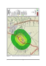
7.2.2.1. Identified Sensitive Receptors<br />
A sensitive receptor for the purposes of the current investigation can be defined as a<br />
person or place where involuntary exposure to pollutants released by the proposed<br />
plant, can be expected to take place. For the purposes of this study, areas of<br />
development are identified as sensitive receptors. Those receptors identified during<br />
the current study are listed as follows:<br />
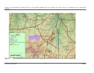
• Approximately 5km south west are Rietfontein and eZamokuhle Towns;<br />
E02.JNB.000308<br />
ESKOM HOLDINGS LIMITED<br />
01<br />
52<br />
08/10/2009