Part 2 - Eskom
Part 2 - Eskom
Part 2 - Eskom

You also want an ePaper? Increase the reach of your titles
YUMPU automatically turns print PDFs into web optimized ePapers that Google loves.
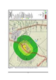
ENVIRONMENTAL SCOPING REPORT FOR THE PROPOSED 40MW OPEN CYCLE GAS TURBINE POWER<br />
PLANT IN THE AMERSFOORT AREA, MPUMALANGA<br />
Bohlweki-SSI Environmental<br />
regarded as Vulnerable 2 , with a planned conservation target of 27%. None is<br />
however formally protected. Some 25% of this unit (Amersfoort Highveld Clay<br />
Grassland) is transformed, predominantly by cultivation (22%). The area is not<br />
suited to forestation. Silver and black wattle and Salix babylonica invade drainage<br />
areas. Erosion potential is low.<br />
Overgrazing leads to invasion of Stoebe vulgaris (Bankrupt Bush). <strong>Part</strong>s of this unit<br />
(Amersfoort Highveld Clay Grassland) were once cultivated and now lie fallow and<br />
have been left to re-vegetate with pioneer grass species. These transformed areas<br />
are not picked up by satellite for transformation coverage and the percentage of<br />
grasslands still in a natural state may be underestimated.<br />
The study area is situated within the African Grasslands/Ekengela Initiative Transition<br />
Zone, rendering all areas of natural grassland sensitive 3 .<br />
7.1.10.2. Soweto Highveld Grassland<br />
This vegetation type comprises a gently to moderately undulating landscape on the<br />
Highveld plateau supporting short to medium-high, dense, tufted grassland<br />
dominated almost entirely by Themeda triandra and accompanied by a variety of<br />
other grasses such as Elionurus muticus, Eragrostis racemosa, Heteropogon<br />
contortus and Tristachya leucothrix. Only scattered small wetlands, narrow stream<br />
alluvia, pans and occasional ridges or rocky outcrops interrupt the continuous<br />
grassland cover.<br />
This vegetation type is regarded Endangered with a planned conservation target of<br />
24%. Erosion is generally very low.<br />
7.2. The Social Environment<br />
7.2.1. Social<br />
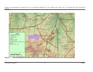
As mentioned earlier, the study area falls within the Pixley ka Seme Local<br />
Municipality (PSLM). According to the Spatial Development Framework (SDF) 4 of the<br />
PSLM, the current spatial pattern within the municipal area can be divided into 7<br />
broad categories of land use, namely: Urban land use, rural land use, mines and<br />
quarries, conservation areas, agriculture, tourism areas, and the transport network.<br />
• Urban land use: The towns of Volksrust and Vukuzakhe are classified as major<br />
urban areas whereas Wakkerstroom, Daggakraal and Amersfoort are regarded<br />
as minor urban areas. An area such as Perdekop is regarded as a declining<br />
urban area.<br />
2<br />
Vegetation types that have lost up to 20% of their original extent, which could result in some<br />
ecosystem function being altered.<br />
3<br />
Department of Environmental Affairs and Tourism; 2001. Environmental Potential Atlas. Pretoria.<br />
4<br />
Pixley ka Seme Local Municipality, 2001. Pixley ka Seme Local Municipality IDP. Available at URL<br />
http://pixleykaseme.local.gov.za.<br />
E02.JNB.000308<br />
ESKOM HOLDINGS LIMITED<br />
01<br />
51<br />
08/10/2009