Part 2 - Eskom
Part 2 - Eskom
Part 2 - Eskom

Create successful ePaper yourself
Turn your PDF publications into a flip-book with our unique Google optimized e-Paper software.
ENVIRONMENTAL SCOPING REPORT FOR THE PROPOSED 40MW OPEN CYCLE GAS TURBINE POWER<br />
PLANT IN THE AMERSFOORT AREA, MPUMALANGA<br />
SOILS LAND CAPABILITY<br />
AND LAND USE<br />
Land type: Ca2<br />
Landscape dominated by Mainly dryland<br />
shallow yellow-brown agriculture and<br />
apedal, distrophic soils in extensive grazing<br />
higher lying areas,<br />
variable depth bleached<br />
apedal soils in midslope<br />
positions and poorly<br />
drained structured soils<br />
of variable depth in low<br />
lying areas<br />
Bohlweki-SSI Environmental<br />
AGRICULTURAL<br />
POTENTIAL<br />
Medium to low except for<br />
lower lying areas that<br />
constitute wetlands<br />
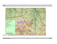
7.1.9.2. Aerial Photograph Interpretation and Land Use/Capability Mapping<br />
The interpretation of aerial photographs yielded eight land use categories. These<br />
categories, as well as the areas and percentages they cover, are presented in Table<br />
7.4. The spatial results of the aerial photograph interpretation are presented in<br />
Appendix F – Land use map). The land capability mimics the current land use and as<br />
such is included in Table 7.4.<br />
Table 7.4: Land use and capability of the study area<br />
Land use Land Capability Area (ha) Percentage (%)<br />
Grasslands Grazing 8759.9 70.8<br />
Dryland Agriculture Arable 3155.9 25.5<br />
Woodland Grazing/Arable 46.8 0.4<br />
Dam Wetland 143.0 1.2<br />
Pan Wetland 8.9 0.1<br />
Rural Infrastructure - 19.3 0.2<br />
Urban Infrastructure - 218.5 1.8<br />
Mining Infrastructure - 28.8 0.2<br />
Total 12381.1 100.2<br />
7.1.10. Regional Vegetation<br />
The study area is situated within the Amersfoort Highveld Clay Grassland and<br />
Soweto Highveld Grassland vegetation types (refer to Appendix G).<br />
7.1.10.1. Amersfoort Highveld Clay Grassland<br />
This vegetation type comprises undulating grassland plains, with small scattered<br />
patches of dolerite outcrops in areas. The vegetation is comprised of a short closed<br />
grassland cover, largely dominated by a dense Themeda triandra (Red Grass)<br />
sward, often severely grazed to form a short lawn. The conservation status is<br />
E02.JNB.000308<br />
ESKOM HOLDINGS LIMITED<br />
01<br />
50<br />
08/10/2009