Part 2 - Eskom
Part 2 - Eskom
Part 2 - Eskom

You also want an ePaper? Increase the reach of your titles
YUMPU automatically turns print PDFs into web optimized ePapers that Google loves.
ENVIRONMENTAL SCOPING REPORT FOR THE PROPOSED 40MW OPEN CYCLE GAS TURBINE POWER<br />
PLANT IN THE AMERSFOORT AREA, MPUMALANGA<br />
Bohlweki-SSI Environmental<br />
Alfred seam by a parting of coaly shale that becomes thicker and more arenaceous<br />
to the east. The Gus seam averages over 3.0m in thickness and is divided into a<br />
poor shaly top half and a high quality bottom half. Again the coal shows signs of<br />
devolatilisation.<br />
7.1.6. Geohydrology<br />
The groundwater potential of the Karoo formations located in the study area is limited<br />
in their pristine state due to low permeability and storage capacity. Secondary<br />
processes, such as weathering, fracturing, etc., are required to enhance the<br />
groundwater potential. Based on regional data and the resource maps, the following<br />
geohydrological information is available for the formations within the study area:<br />
• Volksrust Formation<br />
־ Upper and middle Ecca<br />
־ Predominantly argillaceous rocks<br />
־ Fractured aquifers<br />
־ Borehole yields 0.5 to 2.0 l/s<br />
• Vryheid Formation<br />
־ Lower Ecca<br />
־ Intergranular and fractured aquifers<br />
־ Borehole yields 0.1 to 0.5 l/s<br />
Groundwater hydrochemistry associated with the sediments is variable; the<br />
groundwater salinity associated with the formations in the study area can have<br />
electrical conductivity concentrations of < 250 up to 1000 mS/m.<br />
The sandstones of the Vryheid Formation of the Ecca Group can be massive and<br />
dense and have limited permeability and storage. It thus offers only moderate<br />
groundwater yield, especially in the absence of dolerite intrusions. Contacts between<br />
different rock lithologies and bedding planes within the sediments often yield<br />
groundwater. The contact zone between the dolerites and the sandstone lithologies<br />
can be high yielding. Fractured fault zones, especially if related to tensional stresses,<br />
are potentially rich targets for groundwater development. Groundwater occurs within<br />
the joints, bedding planes, and along dolerite contacts within the sediments (as<br />
recognised across the study area).<br />
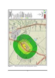
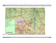
7.1.7. Drainage and Hydrology<br />
The site straddles two quaternary catchments, both of which form part of the Upper<br />
Vaal River Catchment. The western part of the site is located within catchment C11J,<br />
part of which is drained by the Witbankspruit, a stream that forms a tributary of the<br />
Upper Vaal River to the north of the site (the Witbankspruit flows from north to south<br />
across the site). The eastern third of the site falls within the quartenary catchment<br />
C11E. The Skulpspruit which flows through the eastern part of the site forms a<br />
tributary of the Rietspruit, itself a tributary of the Upper Vaal River. This factor is<br />
relatively important in a catchment management context as the Vaal River is critical<br />
in the supply of water to South Africa’s most densely populated area and economic<br />
hub.<br />
E02.JNB.000308<br />
ESKOM HOLDINGS LIMITED<br />
01<br />
47<br />
08/10/2009