App G (VIA)part2 - Eskom
App G (VIA)part2 - Eskom
App G (VIA)part2 - Eskom

You also want an ePaper? Increase the reach of your titles
YUMPU automatically turns print PDFs into web optimized ePapers that Google loves.
• 31-60 points: Medium (where the impact could influence the decision to<br />
develop in the area)<br />
• >60: High (where the impact must have an influence on the decision to<br />
develop in the area)<br />
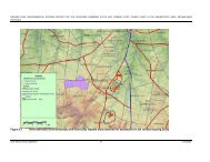
The potential visual impact of the power station conversion on users of<br />
Dassenberg Road<br />
As indicated above, the primary area of potential visual impact would occur along<br />
this section of road within a 200m radius of the power station conversion and<br />
additionally constructed infrastructure. It must however be borne in mind that the<br />
visual impact associated with the power station conversion will be an additional<br />
impact and that the initial visual impact has already occurred during the construction<br />
of the original OCGT power plant and its associated infrastructure. This initial visual<br />
impact was further compounded by the capacity increase (i.e. the construction of<br />
additional OCGT units) as addressed by a previous visual impact assessment report<br />
(MetroGIS (Pty) Ltd, 2007).<br />
The envisaged visual impact of the power station conversion and the construction of<br />
additional fuel storage tanks, as well as the proposed water reservoir are therefore<br />
not as significant as would be the case if this had been a "green fields" development<br />
site. The increase in power generating developments along the Dassenberg Road is<br />
however still expected to increase the cumulative visual impact on observers<br />
travelling past the facility, as more structures would be visible along a longer stretch<br />
of road due to the increased height of the structures (i.e. the 60 m high stacks<br />
associated with the CCGT units) and the additional fuel tanks.<br />
The table below quantifies the potential visual impact of the proposed power station<br />
conversion and construction of ancillary infrastructure.<br />
Table 1: Impact table summarising the significance of visual impacts - power<br />
station conversion.<br />
Nature of Impact:<br />
Potential visual impact on users of Dassenberg road.<br />
Without mitigation With mitigation<br />
Extent Local (4) Local (4)<br />
Duration Long term (4) Long term (4)<br />
Magnitude High (7) High (6)<br />
Probability Highly probable (4) Highly probable (4)<br />
Significance High (60) Medium (56)<br />
Status (positive or<br />
negative)<br />
Negative Negative<br />
Reversibility None None<br />
Irreplaceable loss of<br />
resources?<br />
No No<br />
Can impacts be<br />
mitigated?<br />
Mitigation:<br />
Yes (partially) NA<br />
• Additional infrastructure (such as the water reservoir and fuel storage tanks)<br />
should be set back (further away) from the road as far as possible.<br />
• The viability of the construction of a five to ten metre tall vegetated screening<br />
berm between the Dassenberg Road and the power station site (as proposed in the<br />
OCGT capacity increase <strong>VIA</strong> report) should be investigated.<br />
24