Final Draft Scoping Report - Eskom
Final Draft Scoping Report - Eskom
Final Draft Scoping Report - Eskom

You also want an ePaper? Increase the reach of your titles
YUMPU automatically turns print PDFs into web optimized ePapers that Google loves.
DEA REF: 14/12/16/3/3/3/51<br />
NEAS REF: DEA/EIA/0001413/2012<br />
APPLICATION FOR INTEGRATED<br />
ENVIRONMENTAL AUTHORISATION AND<br />
WASTE MANAGEMENT LICENCE IN TERMS<br />
OF THE:<br />
NATIONAL ENVIRONMENTAL<br />
MANAGEMENT ACT, 1998 (ACT 107 OF<br />
1998) AS AMENDED AND THE<br />
ENVIRONMENTAL IMPACT ASSESSMENT<br />
REGULATIONS 2010; AND<br />
NATIONAL ENVIRONMENTAL<br />
MANAGEMENT: WASTE ACT, 2008 (ACT 59<br />
OF 2008) AND GOVERNMENT NOTICE 718<br />
OF 2009<br />
DRAFT SCOPING REPORT<br />
Division Presenting<br />
A&IRM Environmental Division<br />
Document Prepared by<br />
SEBATA INSTITUTE
10 April 2013<br />
Integrated Waste Management Licence Application for the Kusile Coal Fired Power Station: <strong>Draft</strong> <strong>Scoping</strong> <strong>Report</strong><br />
INTEGRATED WASTE MANAGEMENT LICENCE APPLICATION FOR<br />
TABLE OF CONTENTS<br />
THE KUSILE COAL FIRED POWER STATION<br />
DRAFT SCOPING REPORT<br />
(Ref. No. 14/12/16/3/3/3/51)<br />
1. INTRODUCTION ........................................................................................................... 1<br />
1.1 BACKGROUND ...................................................................................................... 1<br />
1.2 PURPOSE OF THIS STUDY .................................................................................. 5<br />
1.3 THE OBJECTIVES OF THIS REPORT ................................................................... 5<br />
1.4 APPLICANT ............................................................................................................ 9<br />
1.5 DETAILS OF THE ENVIRONEMNTAL ASSESSMENT PRACTITIONER ............. 10<br />
1.6 STRUCTURE OF THIS REPORT ......................................................................... 10<br />
2. LOCATION OF PROJECT .......................................................................................... 12<br />
3. PROJECT DESCRIPTION ........................................................................................... 16<br />
3.1 ASH DISPOSAL PROCESS ................................................................................. 16<br />
3.2 ASH/GYPSUM DISPOSAL FACILITY ................................................................... 17<br />
3.3 ASH/GYPSUM DUMP DEPOSITION MODELLING .............................................. 17<br />
3.4 ASH/GYPSUM DISPOSAL FACILITY FLOOD HYDROLOGY .............................. 17<br />
3.5 ASH/GYPSUM DISPOSAL FACILITY STABILITY ................................................ 18<br />
3.6 ASH DUMP DIRTY WATER DAM ......................................................................... 18<br />
3.7 RADIAL STACKER ............................................................................................... 18<br />
3.8 EMERGENCY ASH DUMP (EAD) AREA .............................................................. 19<br />
3.9 STATION DIRTY DAM .......................................................................................... 20<br />
3.10 STATION DIRTY DAM SETTLING TANK ............................................................. 21<br />
3.11 FLUE GAS DESULPHURISATION WASTEWATER TREATMENT PLANT .......... 21<br />
3.12 SPOIL AREAS ...................................................................................................... 22<br />
4. AMOUNTS OF WASTE TO BE DISPOSED OF .......................................................... 23<br />
5. POTENTIAL ALTERNATIVES .................................................................................... 26<br />
6. LEGISLATION AND GUIDELINES .............................................................................. 28<br />
6.1 NATIONAL ENVIRONMENTAL MANAGEMENT: WASTE ACT ............................ 28<br />
6.2 NATIONAL ENVIRONMENTAL MANAGEMENT ACT .......................................... 28<br />
6.3 NATIONAL WATER ACT, 1998 (ACT NO. 36 OF 1998) ....................................... 29<br />
i
10 April 2013<br />
Integrated Waste Management Licence Application for the Kusile Coal Fired Power Station: <strong>Draft</strong> <strong>Scoping</strong> <strong>Report</strong><br />
6.4 THE KYOTO PROTOCOL .................................................................................... 30<br />
6.5 GUIDELINE DOCUMENTS ................................................................................... 31<br />
7. DESCRIPTION OF THE RECEIVING ENVIRONMENT ............................................... 33<br />
7.1 CATCHMENT ....................................................................................................... 33<br />
7.2 CLIMATE .............................................................................................................. 33<br />
7.2.1 Regional Climate ........................................................................................... 33<br />
7.2.2 Rainfall........................................................................................................... 33<br />
7.3 SOIL AND LAND CAPABILITY ............................................................................. 33<br />
7.4 TOPOGRAPHY .................................................................................................... 34<br />
7.5 GEOLOGY ............................................................................................................ 34<br />
7.6 SURFACE WATER HYDROLOGY ....................................................................... 34<br />
7.7 SENSITIVE AREAS .............................................................................................. 35<br />
7.8 GROUNDWATER ................................................................................................. 35<br />
8. PUBLIC PARTICIPATION PROCESS ......................................................................... 36<br />
8.1 BACKGROUND .................................................................................................... 36<br />
8.2 OBJECTIVES ....................................................................................................... 36<br />
8.3 THE PROCESS FOLLOWED ............................................................................... 37<br />
8.4 COMMENTS FROM I&APS ON THE DRAFT REPORT ....................................... 39<br />
9. SUMMARY OF THE ISSUES IDENTIFIED .................................................................. 40<br />
9.1.1 Heritage Resources ....................................................................................... 40<br />
9.1.2 Waste Classification ....................................................................................... 40<br />
9.2 POTENTIAL IMPACTS ......................................................................................... 41<br />
9.2.1 Groundwater Quality ...................................................................................... 41<br />
9.2.2 Surface Water Quality .................................................................................... 42<br />
9.2.3 Air Quality ...................................................................................................... 42<br />
9.2.4 Aquatic Ecology ............................................................................................. 43<br />
9.2.5 Terrestrial Ecology ......................................................................................... 44<br />
9.2.6 Construction related impacts .......................................................................... 44<br />
10. PLAN OF STUDY FOR EIA ..................................................................................... 45<br />
10.1 SPECIALIST STUDIES ......................................................................................... 45<br />
10.2 PUBLIC PARTICIPATION PROCESS .................................................................. 46<br />
10.3 AUTHORITY CONSULTATION ............................................................................ 48<br />
11. CONCLUSION AND RECOMMENDATIONS ........................................................... 49<br />
12. REFERENCES ......................................................................................................... 51<br />
LIST OF FIGURES<br />
FIGURE 2-1: KUSILE PROJECT LOCATION ..................................................................... 13<br />
ii
10 April 2013<br />
Integrated Waste Management Licence Application for the Kusile Coal Fired Power Station: <strong>Draft</strong> <strong>Scoping</strong> <strong>Report</strong><br />
FIGURE 2-2: KUSILE SITE LAYOUT PLAN ........................................................................ 14<br />
FIGURE 2-3: KUSILE SITE LAYOUT PLAN ........................................................................ 15<br />
FIGURE 8-1: SITE NOTICES PLACED AT AND AROUND THE KUSILE POWER ............. 37<br />
FIGURE 8-2: NEWSPAPER ADVERTISEMENTS .............................................................. 38<br />
LIST OF TABLES<br />
TABLE 1-1: SUMMARY OF NEMA LISTED ACTIVITIES BEING APPLIED FOR ............... 2<br />
TABLE 1-2: SUMMARY OF NEMWA LISTED ACTIVITIES BEING APPLIED FOR ............ 3<br />
TABLE 1-3: SUMMARY OF AUTHORISED WASTE ACTIVITIES AT KUSILE .................... 4<br />
TABLE 1-4: REQUIREMENTS OF EIA REGULATIONS NO. R 543 (2010) ........................ 6<br />
TABLE 4-1: SUMMARY OF WASTE SITES BEING APPLIED FOR ................................. 24<br />
TABLE 10-1: PROPOSED PROGRAMME .......................................................................... 46<br />
APPENDICES<br />
APPENDIX A: 2006 EIA REPORT<br />
APPENDIX B: 2006 ENVIRONMENTAL MANAGEMENT PROGRAMME<br />
APPENDIX C: ENVIRONMENTAL AUTHORISATION<br />
APPENDIX D: 2010 KUSILE WASTE MANAGEMENT LICENCE<br />
APPENDIX E: DESIGN REPORTS<br />
APPENDIX F: ASH/GYPSUM DISPOSAL PROCESS FLOW DIAGRAM<br />
APPENDIX G: SECTION 21 (G) WATER USE LICENCE<br />
APPENDIX H: LIST OF INTERESTED AND AFFECTED PARTIES<br />
APPENDIX I: 2006 SPECIALIST STUDIES<br />
iii
10 April 2013<br />
Integrated Waste Management Licence Application for the Kusile Coal Fired Power Station: <strong>Draft</strong> <strong>Scoping</strong> <strong>Report</strong><br />
LIST OF ABBREVIATION<br />
ADDD Ash Dump Dirty Water Dam<br />
BID Background Information Document<br />
DEA Department of Environmental Affairs<br />
DEAT Department of Environmental Affairs and Tourism<br />
DWA Department of Water Affairs<br />
EA Environmental Authorisation<br />
EAD Emergency Ash Dump<br />
EAP Environmental Assessment Practitioner<br />
ECA Environmental Conservation Act, 1989 (Act of 73 1989)<br />
EIA Environmental Impact Assessment<br />
EIR Environmental Impact <strong>Report</strong><br />
EMP Environmental Management Programme<br />
IDP Integrated Development Plan<br />
FGD Flue Gas Desulphurisation<br />
ISP Internal Strategic Perspective<br />
GN Government Notice<br />
HDPE High Density Polyethylene<br />
I&APs Interested and Affected Parties<br />
IAIA International Association for Impact Assessment<br />
NEMA National Environmental Management Act, 1998 (Act 107 of 1998)<br />
NEMWA National Environmental Management: Waste Act, 2008 (Act 59 of<br />
2008)<br />
NWA National Water Act, 1998 (Act 36 of 1998)<br />
NPV Net Present Value<br />
PPP Public Participation Process<br />
RN Registration Number<br />
SDD Station Dirty Water Dam<br />
SDD ST Station Dirty Water Dam Settling Tank<br />
UNFCCC United Nations Framework Convention on Climate Change<br />
WML Waste Management Licence<br />
WMLA Waste Management Licence Application<br />
WULA Water Use Licence Application<br />
iv
10 April 2013<br />
Integrated Waste Management Licence Application for the Kusile Coal Fired Power Station: <strong>Draft</strong> <strong>Scoping</strong> <strong>Report</strong><br />
LIST OF UNITS<br />
ha hectares<br />
km kilometres<br />
MW Megawatts<br />
ℓ/s litres per second<br />
m metres<br />
mamsl metres above mean sea level<br />
mm millimetres<br />
m 3<br />
cubic metres<br />
% percentage<br />
m 3 /a cubic metres per annum<br />
mm/a millimetres per annum<br />
v
10 April 2013<br />
Integrated Waste Management Licence Application for the Kusile Coal Fired Power Station: <strong>Draft</strong> <strong>Scoping</strong> <strong>Report</strong><br />
1. INTRODUCTION<br />
1.1 BACKGROUND<br />
In 2006 <strong>Eskom</strong> Holdings initiated an Environmental Impact Assessment (EIA),<br />
undertaken by Ninham Shand (Pty) Ltd, for the construction of a 4 800 MW Kusile<br />
Coal-Fired Power Station and associated infrastructure in the Witbank area. The<br />
power station covers approximately 2 500 ha of land on the Farm Hartebeesfontein<br />
537 JR and the Farm Klipfontein 566 JR. The power station precinct includes the<br />
power station building, administration buildings (administrative, medical,<br />
maintenance, services) and the high voltage yard. The associated infrastructure<br />
applied for during the EIA included a water treatment works, a wastewater treatment<br />
works, access roads, railway line, water supply pipelines, a coal stockyard, an ash<br />
disposal facility, a coal and ash conveyor system and water storage facilities.<br />
Ninham Shand concluded that the proposed development would not conflict with the<br />
principles of the Environmental Conservation Act (ECA), 1989 (Act No. 73 of 1989),<br />
that the Public Participation Process (PPP) was undertaken as per relevant<br />
regulations and the issues of the Interested and Affected Parties (I&APs) were<br />
adequately addressed. Ninham Shand therefore recommended that the proposed<br />
development should be authorised subject to the implementation and enforcement of<br />
the recommendations and mitigation measures contained in the EIA <strong>Report</strong> and<br />
Environmental Management Plan (EMP) (Please refer to Appendix A and B for<br />
copies of the EIA <strong>Report</strong> and the EMP respectively).<br />
In June 2007, the Department of Environmental Affairs (DEA) issued a positive<br />
Environmental Authorisation (EA) (Ref: 12/12/20/807) for the construction of the<br />
Kusile Coal Fired Power Station and Associated Infrastructure in the Witbank Area,<br />
Mpumalanga Province (Please refer to Appendix C for a copy of the EA). This June<br />
2007 EA was appealed and a revised EA was issued in March 2008 under the ECA.<br />
In terms of this EA, <strong>Eskom</strong> can construct the power station and operate ash disposal<br />
systems. The EA also states that Kusile Power Station will have Flue Gas<br />
Desulphurisation (FGD) technology to minimize particulate and SO2 emissions. As a<br />
result of FGD technology, gypsum shall be produced as a by-product during<br />
operation of the power station.<br />
At the time of the EIA, <strong>Eskom</strong>’s intention was to dispose of ash only at the ash<br />
disposal facility and initiated an investigation to determine existing potential<br />
1
10 April 2013<br />
Integrated Waste Management Licence Application for the Kusile Coal Fired Power Station: <strong>Draft</strong> <strong>Scoping</strong> <strong>Report</strong><br />
opportunities in the market which would result in the use of gypsum. Although the<br />
possibility of gypsum being generated through the FGD process and the commercial<br />
value related to it was discussed in the final EIA <strong>Report</strong>, the disposal of gypsum on<br />
the ash dump was not included. The co-disposal of gypsum with ash is therefore not<br />
authorised.<br />
Since gypsum is considered to be a hazardous waste (classified as a medium<br />
hazardous waste), a Waste Management Licence (WML) must be applied for to co-<br />
dispose ash and gypsum as a listed activity 9, Category B of GN718 and the<br />
construction of the facility (Ash/gypsum dump, the Ash Dump Dirty Water Dam<br />
(ADDD), the Station Dirty Water Dam (SDD) and the station dirty dam settling tanks<br />
(SDD ST)) will trigger activity 11, Category B of GN 718.<br />
In addition to the hazardous waste that will be disposed of at Kusile, general waste<br />
including rock spoils (the concrete rock spoil and K3 spoils) produced during<br />
construction will also be temporarily stored on site.<br />
The construction of the ADDD within a wetland will trigger activities 11 and 18 of GN<br />
R544. Table 1-1 and Table 1-2 give a summary of the National Environmental<br />
Management Act, 1998 (Act 107 of 1998) (NEMA) and National Environmental<br />
Management: Waste Act, 2008 (Act 59 of 2008) (NEMWA) activities that will be<br />
triggered as a result of the various waste activities at Kusile.<br />
Table 1-1: Summary of NEMA Listed Activities being applied for<br />
Number and<br />
date of the<br />
relevant<br />
notice:<br />
Government<br />
Gazette<br />
R544<br />
2 August<br />
2010<br />
Activity No<br />
(s) (in<br />
terms of<br />
the relevant<br />
or notice) :<br />
Description of each listed activity as per the<br />
detailed project description (and not as per<br />
wording of the relevant Government Notice):<br />
11 The construction of the Ash Dump Dirty Water Dam<br />
18<br />
(ADDD) and settling dams within a wetland.<br />
Removing soil located in a wetland for the<br />
construction of a waste management facility and<br />
depositing ash/gypsum waste material exceeding<br />
5 m 3 into the wetland for storage purposes using a<br />
waste management facility.<br />
2
10 April 2013<br />
Integrated Waste Management Licence Application for the Kusile Coal Fired Power Station: <strong>Draft</strong> <strong>Scoping</strong> <strong>Report</strong><br />
Table 1-2: Summary of NEMWA Listed Activities being applied for<br />
No. & Date<br />
Of The<br />
Relevant<br />
Notice:<br />
Government<br />
Notice 718 of<br />
3 July 2009<br />
Government<br />
Notice 718 of<br />
3 July 2009<br />
Activity<br />
Numbers (As<br />
Listed In The<br />
Waste<br />
Management<br />
Activity List) :<br />
Category A 3<br />
(1)<br />
Description of Listed Activity<br />
The temporary storage of silty soils and<br />
degradable rock which is not suitable for use as<br />
general backfill within the project (classified as<br />
general waste) at the K 3 spoil stockpile that<br />
has the capacity to store in excess of 100 m 3 .<br />
The temporary storage of construction waste<br />
(mainly concrete, unusable soil, rebar and<br />
unwanted material, classified as general waste)<br />
at the Concrete spoil stockpile that has the<br />
capacity to store in excess of 100 m 3 .<br />
Category B (9) The co-disposal and storage of ash and<br />
Category B (11)<br />
gypsum which has been classified as a<br />
moderate hazardous waste to land.<br />
The disposal of the belt filter press sludge<br />
(gypsum) from the FDG process to land.<br />
The construction of a hazardous waste facility<br />
(Ash/Gypsum Dump) and its associated dams<br />
(Ash Dump Dirty Water Dam, Station Dirty<br />
Water Dam and Station Dirty Water Dam<br />
Settling Tank).<br />
The March 2008 Environmental Authorisation granted Kusile Power Station<br />
permission to construct a number of waste related facilities (DEA Ref: 12/12/20/807).<br />
In May 2010, Kusile Power Station was also granted a waste management licence<br />
(DEA Ref: 12/9/11/L193/6) (Appendix D) for additional waste activities. The<br />
authorised waste activities are summarised in Table 1-3.<br />
3
10 April 2013<br />
Integrated Waste Management Licence Application for the Kusile Coal Fired Power Station: <strong>Draft</strong> <strong>Scoping</strong> <strong>Report</strong><br />
Table 1-3: Summary of Authorised Waste Activities at Kusile<br />
No. Activity Comments<br />
1. Sewage treatment<br />
works<br />
2. Coal Stockyard<br />
Pollution Control<br />
Dam (PCD)<br />
3. Potable Raw Water<br />
Treatment (Brine)<br />
4. Water Treatment<br />
Plant<br />
5. Effluent<br />
Neutralisation Plant<br />
6. Holding Recycling<br />
Dams and De-<br />
gritting Sumps<br />
7. Temporary<br />
Demineralisation<br />
Plant<br />
The Sewage Treatment Works were<br />
authorised in terms of the 2008<br />
Environmental Authorisation (DEA Ref:<br />
12/12/20/807).<br />
The Coal Stockyard PCD was authorised in<br />
terms of the 2008 Environmental<br />
Authorisation (DEA Ref: 12/12/20/807).<br />
The Potable Raw Water Treatment (brine)<br />
was authorised in terms of the 2008<br />
Environmental Authorisation, which<br />
authorised water and waste water treatment<br />
facilities (DEA Ref: 12/12/20/807).<br />
The Water Treatment Plant was authorised in<br />
terms of the 2008 Environmental<br />
Authorisation, which authorised water and<br />
waste water treatment facilities (DEA Ref:<br />
12/12/20/807).<br />
The Effluent Neutralisation Plant was<br />
authorised in terms of the 2008<br />
Environmental Authorisation, which<br />
authorised water and waste water treatment<br />
facilities (DEA Ref: 12/12/20/807).<br />
The Holding Recycling Dams and De-gritting<br />
Sumps were authorised in terms of the 2008<br />
Environmental Authorisation, which<br />
authorised water and waste water treatment<br />
facilities (DEA Ref: 12/12/20/807).<br />
The Temporary Demineralisation Plant was<br />
authorised in terms of the 2008<br />
Environmental Authorisation, which<br />
authorised water and waste water treatment<br />
facilities (DEA Ref: 12/12/20/807).<br />
8. Radial Stacker The Radial Stacker was authorised in terms<br />
of the 2008 Environmental Authorisation,<br />
4
10 April 2013<br />
Integrated Waste Management Licence Application for the Kusile Coal Fired Power Station: <strong>Draft</strong> <strong>Scoping</strong> <strong>Report</strong><br />
No. Activity Comments<br />
9. Emergency Ash<br />
Dump (EAD)<br />
10. Hazardous Waste<br />
during construction<br />
11. General Waste<br />
during construction<br />
which authorised ash disposal facility (DEA<br />
Ref: 12/12/20/807).<br />
The EAD was authorised in terms of the 2008<br />
Environmental Authorisation, which<br />
authorised ash disposal facility (DEA Ref:<br />
12/12/20/807).<br />
The hazardous waste produced during<br />
construction was authorised in terms of the<br />
waste licence (DEA Ref: 12/9/11/L193/6).<br />
General waste produced during construction<br />
was authorised in terms of the waste licence<br />
(DEA Ref: 12/9/11/L193/6).<br />
In addition to the activities in Table 1-1 and Table 1-2, <strong>Eskom</strong> is also looking to<br />
consolidate all waste activities into one licence and is requesting that the Department<br />
includes the abovementioned activities (Table 1-3), which were applied for and<br />
authorised prior to the promulgation of the NEMWA, in the Licence.<br />
1.2 PURPOSE OF THIS STUDY<br />
The disposal of hazardous waste is listed in GN718 and therefore requires a WML.<br />
The objectives of this study are to:<br />
• ensure that the environmental effects are taken into account in the planning and<br />
implementation of the planned project;<br />
• promote sustainable development;<br />
• ensure that activities do not have a detrimental effect on the environment;<br />
• facilitate public involvement; and<br />
• provide the information required to enable the Minister to make informed<br />
decisions regarding the authorisation of the project.<br />
1.3 THE OBJECTIVES OF THIS REPORT<br />
The scope of an environmental assessment is defined by the range of issues and<br />
alternatives to be considered, and the approach towards the assessment that will<br />
follow (DEA, 2002). <strong>Scoping</strong> identifies the most important issues that must be<br />
covered in the EIA (Aucamp, 2009), which is the purpose of this report, and<br />
5
10 April 2013<br />
Integrated Waste Management Licence Application for the Kusile Coal Fired Power Station: <strong>Draft</strong> <strong>Scoping</strong> <strong>Report</strong><br />
eliminates those that are of little or no concern. The objectives of this report are to<br />
ensure:-<br />
• that the EIA studies remain focused on the significant effects;<br />
• that time and money are not wasted on unnecessary studies;<br />
• a fair interaction between and/or among all stakeholders to identify the key issues<br />
for investigation;<br />
• that alternatives for achieving the objectives of the proposed activity are given<br />
due consideration;<br />
• that specialists have been appointed to execute the work required, and provided<br />
with adequate terms of reference that are acceptable to all stakeholders; and<br />
• that the roles and responsibilities of various stakeholders in the process have<br />
been clarified, and all participants have agreed on the process to be followed.<br />
<strong>Scoping</strong> has been undertaken in compliance with the EIA Regulations No R. 543 of<br />
2010, as presented in Table 1-4.<br />
Table 1-4: Requirements of EIA Regulations No. R 543 (2010)<br />
Regulation 26 Compliance<br />
a) Completion of the application form for<br />
environmental authorisation of the relevant<br />
activity.<br />
b) (i) a declaration of interest by the EAP on a<br />
form provided by the competent authority;<br />
Integrated Waste Licence<br />
Application Form submitted to DEA<br />
on 23 July 2012 and resubmitted<br />
on 17 August 2012. An amended<br />
application was submitted to the<br />
DEA on 28 February 2013.<br />
Regulation 27 Compliance<br />
a) Public participation process set out in<br />
Regulation 56.<br />
b) Give notice, in writing, of the proposed<br />
application to any organ of state which has<br />
jurisdiction in respect of any aspect of the<br />
activity.<br />
c) Open and maintain a register of all<br />
interested and affected parties in respect of<br />
the application in accordance with<br />
Regulation 57.<br />
d) Consider all objections and representations<br />
Chapter 8<br />
6
10 April 2013<br />
Integrated Waste Management Licence Application for the Kusile Coal Fired Power Station: <strong>Draft</strong> <strong>Scoping</strong> <strong>Report</strong><br />
received from interested and affected<br />
parties following the public participation<br />
process.<br />
e) Subject the application to scoping by<br />
identifying -<br />
(i) issues that will be relevant for<br />
consideration of the application<br />
(ii) the potential environmental impacts of<br />
the proposed activity<br />
(iii) alternatives to the proposed activity that<br />
are feasible and reasonable<br />
f) Prepare a scoping report in accordance<br />
with Regulation 29.<br />
g) Give all registered interested and affected<br />
parties an opportunity to comment on the<br />
scoping report in accordance with<br />
Regulation 58.<br />
Chapter 9<br />
Chapter 5<br />
This report<br />
Chapter 8<br />
Regulation 28 Compliance<br />
1) (a) Details of -<br />
(i) the EAP who prepared the report Chapter 1<br />
(ii) the expertise of the EAP to carry out<br />
scoping procedures<br />
b) A description of the proposed activity<br />
and of any feasible and reasonable<br />
alternatives that have been identified.<br />
c) A description of the property on which<br />
the activity is to be undertaken and the<br />
location of the activity on the property.<br />
d) A description of the environment that<br />
may be affected by the activity and the<br />
manner in which the physical,<br />
biological, social, economic and cultural<br />
aspects of the environment may be<br />
affected by the proposed activity.<br />
e) An identification of all legislation and<br />
guidelines that have been considered in<br />
Chapter 1<br />
Chapters 3, 4 and 5<br />
Chapter 2<br />
Chapter 7<br />
Chapter 6<br />
7
10 April 2013<br />
Integrated Waste Management Licence Application for the Kusile Coal Fired Power Station: <strong>Draft</strong> <strong>Scoping</strong> <strong>Report</strong><br />
the preparation of the scoping report.<br />
f) A description of environmental issues<br />
and potential impacts, including<br />
cumulative impacts that have been<br />
identified.<br />
g) Information on the methodology that will<br />
be adopted in assessing the potential<br />
impacts that have been identified,<br />
including any specialist studies or<br />
specialised processes that will be<br />
undertaken.<br />
h) Details of the public participation<br />
process conducted in terms of<br />
Regulation 28(a), including –<br />
(i) the steps that were taken to notify<br />
potentially interested and affected<br />
parties of the application<br />
(ii) proof that notice boards,<br />
advertisements and notices notifying<br />
potentially interested and affected<br />
parties of the application have been<br />
displayed, placed or given<br />
(iii) a list of all persons or organisations<br />
that were identified and registered in<br />
terms of Regulation 57 as interested<br />
and affected parties in relation to the<br />
application<br />
(iv) a summary of the issues raised by<br />
interested and affected parties, and<br />
the date of receipt of and the<br />
response of the EAP to those issues<br />
i) A plan of study for environmental<br />
impact assessment which sets out the<br />
proposed approach to the<br />
environmental impact assessment of<br />
the application, which must include –<br />
Chapter 9<br />
Chapter 10<br />
Chapter 8<br />
Chapter 10<br />
8
10 April 2013<br />
Integrated Waste Management Licence Application for the Kusile Coal Fired Power Station: <strong>Draft</strong> <strong>Scoping</strong> <strong>Report</strong><br />
(i) a description of the tasks that will be<br />
undertaken as part of the<br />
environmental impact assessment<br />
process, including any specialist<br />
reports or specialised processes,<br />
and the manner in which such tasks<br />
will be undertaken<br />
(ii) an indication of the stages at which<br />
the competent authority will be<br />
consulted<br />
(iii) a description of the proposed method<br />
of assessing the environmental<br />
issues and alternatives, including the<br />
option of not proceeding with the<br />
activity<br />
(iv) particulars of the public participation<br />
process that will be conducted during<br />
the environmental impact<br />
assessment process<br />
2) Any guidelines applicable to the kind of<br />
activity which is the subject of the<br />
application.<br />
1.4 APPLICANT<br />
Chapter 6<br />
The applicant <strong>Eskom</strong> Holdings SOC-Kusile Power Station is represented by:<br />
Mr Abram Masango<br />
Group Capital Division<br />
Kusile Power Station<br />
Suite 46<br />
Postnet<br />
Highveld<br />
1035<br />
Tel: 013 699 7164 or Mobile: 082 888 9276<br />
Facsimile: 086 664 5078<br />
E mail: MasangA@eskom.co.za<br />
9
10 April 2013<br />
Integrated Waste Management Licence Application for the Kusile Coal Fired Power Station: <strong>Draft</strong> <strong>Scoping</strong> <strong>Report</strong><br />
1.5 DETAILS OF THE ENVIRONEMNTAL ASSESSMENT PRACTITIONER<br />
<strong>Eskom</strong> appointed Sebata Institute to conduct the WMLA. The environmental<br />
assessments will be undertaken by Deon Esterhuizen, with assistance from<br />
Ndomupei Dhemba.<br />
Deon Esterhuizen is a certified Professional Natural Scientist (RN: 400154/09) with<br />
a MSc in Environmental Management with 20 years of experience in water related<br />
projects, which include water quality management, registration and licencing of water<br />
users, completion of Environmental Impact Assessments in support of the issuing of<br />
Record of Decisions, development of a management guide for domestic water use,<br />
project management, and implementation of the Resource Directed Measures as<br />
required by the Department of Water Affairs.<br />
Ndomupei Dhemba is a GIS and Remote Sensing specialist with a Masters degree<br />
in GIS and remote sensing for environmental management. She has six years of<br />
experience in natural resources management including resource inventorying and<br />
auditing, biodiversity assessment and spatial planning, GIS and remote sensing, as<br />
well as environmental management. Ndomupei has also undertaken environmental<br />
assessments for projects in Tanzania, Botswana and South Africa. She also assisted<br />
with the applications for amendments to authorisation on the Gautrain.<br />
The contact details of the EAP are as follows;<br />
Deon Esterhuizen<br />
Sebata Institute<br />
PO Box<br />
Highveld Technopark<br />
Centurion<br />
0169<br />
Tel: 012 685 0900 or Mobile 082 445 1781<br />
Facsimile: 012 665 1886<br />
E mail: deon@iliso.com<br />
1.6 STRUCTURE OF THIS REPORT<br />
The project locality is presented in Chapter 2. A full project description is provided in<br />
Chapter 3 and Chapter 4. Alternatives to be considered during the EIA phase are<br />
given in Chapter 5. The legislation that was considered in preparation of this <strong>Scoping</strong><br />
10
10 April 2013<br />
Integrated Waste Management Licence Application for the Kusile Coal Fired Power Station: <strong>Draft</strong> <strong>Scoping</strong> <strong>Report</strong><br />
<strong>Report</strong> is listed in Chapter 6. A description of the receiving environment is presented<br />
in Chapter 7. The details of the public participation process (PPP) are given in<br />
Chapter 8. Chapter 9 contains a summary of issues identified.<br />
Chapter 10 contains a Plan of Study for EIA, which entails the authority consultation,<br />
impact assessment methodology, PPP, and terms of reference for specialist studies.<br />
Chapter 11 provides the conclusion and recommendations for the EIA phase.<br />
Referenced material is presented in Chapter 12.<br />
11
10 April 2013<br />
Integrated Waste Management Licence Application for the Kusile Coal Fired Power Station: <strong>Draft</strong> <strong>Scoping</strong> <strong>Report</strong><br />
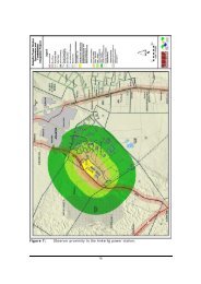
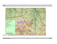
2. LOCATION OF PROJECT<br />
The Kusile Project is located on approximately 2 500 ha on the farms of<br />
Hartbeestfontein 537 JR and Klipfontein 566 JR within the Mpumalanga Province.<br />
The Kusile Project falls within the jurisdiction of the Delmas Local Municipality which<br />
is in the Mpumalanga Province. The largest town within a 30 km radius of the Kusile<br />
Project site is Emalahleni. The smaller town of Kungwini lays approximately 20 km<br />
north-west of the site.<br />
Figure 2-1 shows the Kusile Project location. Figure 2-2 and Figure 2-3 show the<br />
current Project Layout Plan<br />
12
10 April 2013<br />
Integrated Waste Management Licence Application for the Kusile Coal Fired Power Station: <strong>Draft</strong> <strong>Scoping</strong> <strong>Report</strong><br />
Figure 2-1: Kusile Project Location<br />
13
10 April 2013<br />
Integrated Waste Management Licence Application for the Kusile Coal Fired Power Station: <strong>Draft</strong> <strong>Scoping</strong> <strong>Report</strong><br />
Figure 2-2: Kusile Site Layout Plan<br />
14
10 April 2013<br />
Integrated Waste Management Licence Application for the Kusile Coal Fired Power Station: <strong>Draft</strong> <strong>Scoping</strong> <strong>Report</strong><br />
Figure 2-3: Kusile Site Layout Plan<br />
15
10 April 2013<br />
Integrated Waste Management Licence Application for the Kusile Coal Fired Power Station: <strong>Draft</strong> <strong>Scoping</strong> <strong>Report</strong><br />
3. PROJECT DESCRIPTION<br />
The Kusile Project entails the construction of the following:<br />
Power Station Precinct:<br />
i) Power station buildings<br />
ii) Administration buildings (control buildings, medical, security, etc);<br />
iii) High voltage yard<br />
Associated Infrastructure:<br />
i) Coal stock yard<br />
ii) Coal and ash conveyors<br />
iii) Water supply pipelines (temporary and permanent)<br />
iv) Water and waste water treatment facilities<br />
v) Ash disposal system<br />
vi) Access roads (including haul roads)<br />
vii) Dams for water storage<br />
viii) Railway siding and/or line for sorbent supply<br />
This integrated waste management licence application is applicable to the following:<br />
• The ash/gypsum disposal facility and the ADDD;<br />
• The SDD and the SDD ST; and<br />
• Concrete and K3 Stockpile Areas.<br />
All the design <strong>Report</strong>s are attached in Appendix E.<br />
3.1 ASH DISPOSAL PROCESS<br />
Above ground ash disposal will be used. The ash produced through the combustion<br />
of the coal will be removed from the bottom of the boiler (boiler bottom ash) and the<br />
fly ash removed from the top of the boiler together with the flue gas (via electrostatic<br />
precipitators or bag filters) and sent to an ash/gypsum dump.<br />
The Flue Gas Desulphurisation (FGD) process that will be used to reduce sulphur<br />
emissions will also result in filter cake/gypsum which will be transported via a<br />
conveyer belt to the ash/gypsum disposal facility.<br />
16
10 April 2013<br />
Integrated Waste Management Licence Application for the Kusile Coal Fired Power Station: <strong>Draft</strong> <strong>Scoping</strong> <strong>Report</strong><br />
3.2 ASH/GYPSUM DISPOSAL FACILITY<br />
The ash/gypsum disposal facility will be located to the south of the power station, on<br />
high ground between two drainage paths. Construction of the facility will entail:<br />
• Excavate and construct the dirty water concrete channels in 1 000 m lengths at a<br />
time.<br />
• Backfill trenches after completion of each section.<br />
• Construct perimeter road bed and balance of culvert crossings over 1 000 m<br />
lengths at a time.<br />
• Excavate and form clean water drains in 1 000 m sections together with culverts<br />
and culvert discharge trenches to silt retention dams.<br />
• Topsoil removal and foundation preparation in 0.25 km squared sections of the<br />
phase one footprint to receive the liner sandwich installation (also installed in<br />
0.25 km squared sections).<br />
• Deliver, spread and tip the 300 mm G5 protection layer over the installed liner as<br />
soon as each 0.25 km squared section is complete.<br />
• Form toe wall to each liner panel section, including drainage pipes at 75 m<br />
intervals for storm water discharge to the silt retention dams.<br />
The disposal of ash/ gypsum is to be undertaken as follows:<br />
Place the ash/gypsum onto the ash/gypsum disposal facility for the first 4 years of<br />
power station operation by a load and haul operation. The ash and gypsum will be<br />
delivered by conveyer to a radial stacker near the ash/gypsum disposal facility, for<br />
subsequent loading, hauling and placement into paddocks of approximate size 200 m<br />
by 200 m, developed in 2 m lifts, spread initially over the ash/gypsum disposal facility<br />
5-year half-footprint, to full design height on the ash/gypsum disposal facility, and<br />
then similarly over the second half of the footprint.<br />
3.3 ASH/GYPSUM DUMP DEPOSITION MODELLING<br />
The power station comprises six boiler units which will be commissioned one every<br />
eight months, starting December 2014. The full power station ash/gypsum output will<br />
thus only be effective in the 4 th year of operation. In years 6 to 60 of operation, only<br />
gypsum will be placed at significantly reduced tonnages onto the ash/gypsum<br />
disposal facility by the same, but smaller, load and haul operation.<br />
3.4 ASH/GYPSUM DISPOSAL FACILITY FLOOD HYDROLOGY<br />
The ash/gypsum load and haul deposition system will enable the disposal facility<br />
operators to place the ash/gypsum disposal facility in such a manner as to be free<br />
17
10 April 2013<br />
Integrated Waste Management Licence Application for the Kusile Coal Fired Power Station: <strong>Draft</strong> <strong>Scoping</strong> <strong>Report</strong><br />
draining in shape, with minimisation of any depression that will collect and retain<br />
stormwater run-off.<br />
Temporary artificial channels will be constructed on the exposed ash surfaces to lead<br />
stormwater down the faces to the dirty water collection channels in a controlled<br />
manner thereby preventing erosion. Irrigation of the exposed ash surfaces will take<br />
place to achieve dust control. Irrigation water volumes will be restricted as far as<br />
possible to limit any seepage potential arising from the irrigation waters.<br />
3.5 ASH/GYPSUM DISPOSAL FACILITY STABILITY<br />
Exposed ash surfaces will be finally shaped at 1:5 on the side slopes and at 1:200 on<br />
the top surfaces and rehabilitated as soon as practically possible by placement of<br />
selected topsoil and vegetation cover. These areas will be irrigated to promote and<br />
sustain the vegetation.<br />
3.6 ASH DUMP DIRTY WATER DAM<br />
The dirty water collection channels will be routed to the ADDD, which is located<br />
northwest of the disposal facility. The liners for the ADDD will be designed in<br />
accordance with the Department of Water Affair’s (DWA) document “Minimum<br />
Requirements for Waste Disposal by Landfill (1998)” and will be subject to DWA<br />
approval. The ADDD will also have concrete lined sections at the low end of the<br />
ADDD for equipment access and removal of accumulated solids. The water stored in<br />
the ADDD will be used for dust suppression. In case of excessive stormwater in the<br />
ADDD, manual controls will allow gravity flow to the station dirty dam contingent on<br />
water quality. The outlet pipe in the ADDD will be elevated above operation volume<br />
levels to minimize the conveyance of solids to the SDD. Note that a 50 year, 8 day<br />
storm event can be stored in the ADDD for the worst case dirty area of the<br />
ash/gypsum disposal facility and that the ADDD is comprised of two 50 % cells so<br />
that one cell can remain in service while the other cell is being maintained.<br />
3.7 RADIAL STACKER<br />
The Radial Stacker will be located adjacent to the 10-year ash/gypsum dump. Ash<br />
and gypsum will be delivered by conveyor to a radial stacker near the ash/gypsum<br />
disposal facility, for subsequent loading, hauling and placement into paddocks of<br />
approximated size 200 m by 200 m, developed in 2 m lifts. The ash and gypsum will<br />
be spread initially over the ash/gypsum disposal facility 5-year half-footprint, to full<br />
18
10 April 2013<br />
Integrated Waste Management Licence Application for the Kusile Coal Fired Power Station: <strong>Draft</strong> <strong>Scoping</strong> <strong>Report</strong><br />
design height on the ash/gypsum disposal facility, and then similarly over the second<br />
half of the footprint.<br />
For the radial stacker operation, the combined waste product from the overland<br />
conveyors will be stacked in a kidney shaped pile by a radial stacker machine<br />
adjacent to the ash/gypsum disposal facility. The kidney shaped pile will be<br />
reclaimed by mobile equipment and loaded into trucks which will drive into the<br />
ash/gypsum disposal facility and dump the waste product. The radial stacker area<br />
will be large enough to accommodate the pile from the radial stacker and to also<br />
accommodate multiple trucks and mobile equipment working on the pile<br />
simultaneously. The radial stacker area will have a concrete slab with a liner under it<br />
and will be fed by one of the overland link ash conveyors. The other overland link ash<br />
conveyor will discharge directly onto a concrete slab, also lined, and create a conical<br />
shaped pile just North of the radial stacker. This conical shaped pile will be much<br />
smaller than the kidney shaped pile but will be used if the conveyor to the radial<br />
stacker is disabled or separation of the ash and FGD dewatered solids is required.<br />
The liners for the radial stacker will also be designed in accordance with the DWA<br />
Minimum Requirements for Waste Disposal by Landfill (1998)”, and will be subject to<br />
DWA approval.<br />
Should there be a problem with the radial stacker or the 10-year ash/gypsum<br />
disposal facility, the handling system will convey the waste products to an emergency<br />
ash/gypsum disposal facility (EAD) area.<br />
3.8 EMERGENCY ASH DUMP (EAD) AREA<br />
The Emergency Ash Dump (EAD) will consist of a concrete lined area of<br />
approximately 1.4 ha, sloped to fall with a concrete trapezoidal drain on two adjacent<br />
sides and a concrete rectangular channel drain on the other two sides that joins the<br />
trapezoidal drain. The EAD will be used occasionally for the temporary storage of<br />
quenched ash for periods of up to 24 hours, before being removed for permanent<br />
disposal on the appropriately licensed waste disposal facility. The EAD therefore<br />
does not represent the same level of environmental risk as the permanent ash<br />
disposal facility.<br />
The purpose of the EAD is to have a place to stack waste product should both the<br />
overland link ash conveyors become disabled. The EAD is sized to provide 24 hours<br />
storage of bottom ash and FGD dewatered solids for all 6 units running at full<br />
19
10 April 2013<br />
Integrated Waste Management Licence Application for the Kusile Coal Fired Power Station: <strong>Draft</strong> <strong>Scoping</strong> <strong>Report</strong><br />
capacity. The fly ash will be stored in the fly ash silos for up to 24 hours in case of an<br />
emergency. The EAD will have a large concrete slab on which the pile will be<br />
stacked. Underneath the concrete will be a liner which will be designed in<br />
accordance with the DWA Minimum Requirements for Waste Disposal by Landfill,<br />
and will be subject to DWA approval. The concrete slab is designed to contain and<br />
drain the EAD area and direct run off to a sump located on the North West corner of<br />
the slab. After an emergency and once the overland link ash conveyors are<br />
operational again the bottom ash will be reclaimed and loaded onto the overland link<br />
ash conveyors and taken to the ash/gypsum disposal facility.<br />
3.9 STATION DIRTY DAM<br />
All potentially contaminated water on the Kusile Power Station will be managed in a<br />
closed system. The SDD are two equal capacity, lined, temporary holding dams that<br />
act as a collection point for all polluted storm-water and wash-down water on the<br />
Kusile site, before it is pumped to the Holding/Recycle Dams (HRD).<br />
The SDD will receive inflows from two distinct sources:<br />
1) Coal Stockyard Settling Tanks (CSY ST): The CSY ST will receive inflows from<br />
the Coal Stockyard (CSY), EAD, limestone processing area, and a number of grit<br />
sumps. Clarified water leaving the CSY ST will travel via gravity pipeline to the<br />
SDD.<br />
2) Station Dirty Dams Settling Tanks (SDD ST): The SDD ST will receive inflows<br />
from the station terrace area. Clarified water leaving the SDD ST will travel via<br />
gravity pipeline to the SDD.<br />
The SDD will receive gravity discharges of dirty water from the rest of the Kusile<br />
Power Station. It will be the furthest downstream dirty water structure on the site and<br />
therefore is required to be down-gradient from the power station. The natural<br />
contours of the site slope downwards to the north-west, towards the non-perennial<br />
tributary of the Klipfonteinspruit. The SDD will be optimally located approximately<br />
1 km north-west of the power station’s north-west fence corner. The selected position<br />
avoids surrounding wetlands and the 1:100 year flood line of the natural stream. The<br />
SDD elevation will range from 1 441 meters above sea level (masl) at the sump of<br />
Compartment No. 2 to 1 454 masl at the crest of Compartment No. 1.<br />
To prevent contamination to the underlying soil, the SDD is required to be a fully<br />
contained structure. The liners for the SDD will be designed in accordance with the<br />
20
10 April 2013<br />
Integrated Waste Management Licence Application for the Kusile Coal Fired Power Station: <strong>Draft</strong> <strong>Scoping</strong> <strong>Report</strong><br />
DWA Minimum Requirements for Waste Disposal by Landfill (1998)”, and will be<br />
subject to DWA approval.<br />
3.10 STATION DIRTY DAM SETTLING TANK<br />
The SDD ST will be located to the north-west of the main power block, and south-<br />
east of the SDD. This position is down-gradient of the power station terrace and in<br />
close proximity to the SDD. The SDD ST will receive gravity discharges of dirty water<br />
from the power station terrace. The two compartments of the settling tank will be<br />
partially excavated into the natural ground and partially built in a fill terrace. The<br />
terrace elevation was carefully planned in conjunction with the inlet and outlet pipe<br />
hydraulic requirements.<br />
The SDD ST will consist of two equal capacity concrete basins that clarify<br />
contaminated water from the power station terrace before it travels by gravity pipeline<br />
to the SDD. The SDD ST will transmit dirty water inflows from the main power station<br />
terrace via a pipeline, to the SDD.<br />
The SDD ST is designed:<br />
• To pass all of the dirty water runoff from its inflow sources for the 1:50 year, peak<br />
instantaneous storm event.<br />
• With an emergency spillway to accommodate larger events.<br />
• With two equal capacity compartments which can each pass 6.55 m 3 /s. The<br />
water enters each compartment of the SDD ST via four sluice gates (1.75 m 2 ).<br />
The two compartments will allow for occasional maintenance and inspection<br />
access (preferably during the dry season) without interrupting the functionality of<br />
the SDD ST under normal circumstances.<br />
3.11 FLUE GAS DESULPHURISATION WASTEWATER TREATMENT PLANT<br />
The FGD process will result in the production of an FGD wastewater/brine stream<br />
which has significantly high concentrations of chlorides, magnesium, calcium, and<br />
heavy metals. This wastewater cannot be directly re-used elsewhere in the station.<br />
As Kusile Power Station is to be a zero-liquid effluent discharge site, this wastewater<br />
will require specialised treatment. Kusile Power Station will employ a three step<br />
process of 1) Pre-treatment, 2) Evaporation/Concentration, and 3) Crystallisation to<br />
treat this wastewater. This will produce a clean water stream that can be reused,<br />
which allows the power station to reduce its raw water intake by up to 3%. Wastes<br />
will be generated in the pre-treatment step and crystallization step. This waste will be<br />
21
10 April 2013<br />
Integrated Waste Management Licence Application for the Kusile Coal Fired Power Station: <strong>Draft</strong> <strong>Scoping</strong> <strong>Report</strong><br />
in solid form and will consist of the gypsum that will be disposed of at the<br />
ash/gypsum disposal facility and the salts from the FDG Sludge which will be<br />
disposed of at the Holfontein Disposal Facility. The flow diagram for the FGD<br />
Wastewater treatment plant is attached as Appendix F.<br />
3.12 SPOIL AREAS<br />
Two separate spoil areas have been developed at Kusile as follows:<br />
• The Concrete Spoil Stockpile which is a mixture of waste containing mostly<br />
concrete, unusable soil , rebar (re-enforcing steel) and rubbish; and<br />
• The K3 stockpile which will comprise of silty soils and degradable rock which is<br />
not suitable for use as general backfill within the project.<br />
These spoil areas will be temporary. The concrete will be disposed of offsite and the<br />
remaining K3 will be spread out and grass will be planted on top.<br />
22
10 April 2013<br />
Integrated Waste Management Licence Application for the Kusile Coal Fired Power Station: <strong>Draft</strong> <strong>Scoping</strong> <strong>Report</strong><br />
4. AMOUNTS OF WASTE TO BE DISPOSED OF<br />
It is expected that the ash/gypsum dump will handle approximately 3 600 tonnes of<br />
ash and gypsum per day within the first four years, and 21 600 tonnes of ash and<br />
gypsum per day at year 5. For the next 5 years (year 6-10), the amounts of gypsum to<br />
be handled at the ash/gypsum dump will be 2 783.52 tonnes per day. It is expected<br />
that an additional 72 tonnes of gypsum per day will be produced from the FDG as belt<br />
filter press sludge.<br />
The rock spoils to be stored daily at Kusile are estimated to be 75 tonnes at the<br />
concrete spoil area and 500 tonnes at the K3 spoil area. Table 4-1 provides a<br />
summary of all the waste sites that are being applied for and the total amounts of<br />
waste expected to be disposed of at each site.<br />
23
10 April 2013<br />
Integrated Waste Management Licence Application for the Kusile Coal Fired Power Station: <strong>Draft</strong> <strong>Scoping</strong> <strong>Report</strong><br />
Table 4-1: Summary of Waste Sites being applied for<br />
Waste Site Size of facility for a<br />
waste management<br />
activity<br />
Ash/Gypsum<br />
disposal<br />
facility<br />
Ash Dump<br />
Dirty Water<br />
Dam<br />
Station Dirty<br />
Water Dam<br />
The footprint of the<br />
ash/gypsum disposal<br />
facility is approximately<br />
250 ha<br />
The ADDD will be<br />
approximately 7.01 ha.<br />
The footprint of the SDD<br />
is approximately 5.615<br />
ha.<br />
Area where the waste<br />
management activity<br />
takes place<br />
The ash/gypsum<br />
disposal facility will be<br />
located on Farm<br />
Klipfontein 566JR<br />
(Coordinates: 25⁰ 56’<br />
13.05”S, 28⁰ 55’<br />
11.49”E).<br />
The ADDD will be<br />
located on Farm<br />
Klipfontein 566JR<br />
(Coordinates: 25⁰ 55’<br />
54.17”S, 28⁰ 53’<br />
50.35”E).<br />
The Station Dirty Dam<br />
will be located on<br />
Farm Hartbeestfontein<br />
537JR (Coordinates:<br />
25⁰ 55’ 12.82”S, 28⁰<br />
53’ 50.48”E).<br />
Classification of facility in<br />
terms of climatic water<br />
balance<br />
The ash/gypsum disposal<br />
facility is classified as B +<br />
(water excess).<br />
The ADDD is classified as B +<br />
(water excess).<br />
The Station Dirty Water Dam<br />
is classified as B + (water<br />
excess).<br />
24<br />
Type of Facility The quantity of waste<br />
received<br />
Ash is classified as nonhazardous<br />
waste and<br />
gypsum is classified as<br />
a moderate hazardous<br />
waste therefore, the<br />
mixture is classified as a<br />
moderate hazardous<br />
waste. The co-disposal<br />
of ash and gypsum will<br />
require a class H:h (LB + )<br />
waste disposal facility.<br />
The dirty water<br />
collection channels from<br />
the Ash/gypsum dump<br />
will be routed to the<br />
ADDD. The ADDD is<br />
therefore classified as a<br />
hazardous waste<br />
disposal facility. .<br />
The Station Dirty Water<br />
Dam is classified as a<br />
hazardous waste facility.<br />
The total waste storage for the<br />
Ash/gypsum disposal facility will<br />
be 84 423 000 m 3 .<br />
The total waste storage volume<br />
of the ADDD will be 227 410 m 3<br />
The design storage capacity of<br />
each dam with the sloping floors<br />
is 181 890 m 3 .<br />
Station Dirty The footprint of the The Station Dirty Dam The Station Dirty Dam The Station Dirty Water The waste storage volume of the
10 April 2013<br />
Integrated Waste Management Licence Application for the Kusile Coal Fired Power Station: <strong>Draft</strong> <strong>Scoping</strong> <strong>Report</strong><br />
Waste Site Size of facility for a<br />
waste management<br />
activity<br />
Dam Settling<br />
Tank<br />
Rock<br />
Stockpile<br />
Areas<br />
Station Dirty Dam<br />
Settling Tank is<br />
approximately 0.8 ha.<br />
The footprint of the<br />
Concrete Spoil<br />
Stockpile will be<br />
approximately 9.6 ha<br />
and the K3 stockpile will<br />
be approximately 4.84<br />
ha.<br />
Area where the waste<br />
management activity<br />
takes place<br />
Settling Tank will be<br />
located on Farm<br />
Hartbeestfontein<br />
537JR (Coordinates:<br />
25⁰ 55’ 12.82”S, 28⁰<br />
53’ 50.48”E).<br />
The concrete spoil<br />
stockpile will be<br />
located on Farm<br />
Hartbeestfontein<br />
537JR (Coordinates:<br />
25⁰ 55’ 2.15” S and<br />
28⁰ 54’ 30.33” E) and<br />
the K3 spoil area will<br />
be located on Farm<br />
Klipfontein 566JR<br />
(Coordinates: 25⁰ 55’<br />
43.46” S and 28⁰ 55’<br />
4.32” E).<br />
Classification of facility in<br />
terms of climatic water<br />
balance<br />
Settling Tank is classified as<br />
B + (water excess).<br />
The rock stockpile is<br />
classified as B - .<br />
25<br />
Type of Facility The quantity of waste<br />
received<br />
Dam Settling Tank is<br />
classified as a<br />
hazardous waste facility.<br />
The rock stockpile is<br />
classified as General<br />
Waste. It will primarily<br />
consist of silty soils and<br />
degradable rock not<br />
suitable for use as<br />
general backfill.<br />
Station Dirty Dam Settling Tank<br />
will be 7 975 m 3 .<br />
The total waste storage volume<br />
of the concrete spoil stockpile<br />
and K3 stockpile will be<br />
approximately 229 500 m 3 and<br />
750 000 m 3 respectively
10 April 2013<br />
Integrated Waste Management Licence Application for the Kusile Coal Fired Power Station: <strong>Draft</strong> <strong>Scoping</strong> <strong>Report</strong><br />
5. POTENTIAL ALTERNATIVES<br />
An initial site selection study was undertaken by <strong>Eskom</strong> with the objective of describing<br />
the planning process that has resulted in the geographical area in question being<br />
identified for the purpose, as well as initially screening the five potential sites within the<br />
geographical area and identifying the two preferred sites that were the subject of the<br />
2006 EIA.<br />
Detailed assessments were undertaken for a number of specialist fields including<br />
groundwater, terrestrial ecology, and aquatic fauna and flora.<br />
In essence the overall recommendations which were made during the EIA Phase were<br />
that there is no clear distinction between the two sites as their environmental impacts<br />
are similar. The preferred site had the following advantages:<br />
• The geology of the preferred site is such that it is unlikely to allow the rapid<br />
distribution of pollutants through the groundwater, specifically related to the<br />
disposal of ash;<br />
• The preferred site supports a smaller area of high integrity wetlands and offers less<br />
wetland services than the alternative site;<br />
• There are fewer sensitive noise receptors that are likely to be affected by a direct<br />
dry cooled power station at the preferred site;<br />
• There is less land that is cultivated on the preferred site, especially with respect to<br />
irrigated land; and<br />
• The net income per hectare at the preferred site is in excess of 20% lower than the<br />
net income per hectare on the alternative site.<br />
While the differences are marginal, it was concluded that the establishment of a coal<br />
fired power station on the preferred site is likely to have fewer negative impacts on the<br />
biophysical and socio-economic environments. A further conclusion was that it would<br />
be important to consider technical, financial and other factors in deciding on which site<br />
to pursue.<br />
The specific location of the power station, coal stockyard, above-ground ash/gypsum<br />
dump, road access and raw water pipeline corridors as initially identified on the<br />
preferred site were refined, to avoid impacting on high integrity wetlands. The<br />
ash/gypsum dump design was also further refined to avoid impacting on any wetlands<br />
26
10 April 2013<br />
Integrated Waste Management Licence Application for the Kusile Coal Fired Power Station: <strong>Draft</strong> <strong>Scoping</strong> <strong>Report</strong><br />
and a buffer around the wetland as been included in order to preserve and protect the<br />
wetand.<br />
27
10 April 2013<br />
Integrated Waste Management Licence Application for the Kusile Coal Fired Power Station: <strong>Draft</strong> <strong>Scoping</strong> <strong>Report</strong><br />
6. LEGISLATION AND GUIDELINES<br />
6.1 NATIONAL ENVIRONMENTAL MANAGEMENT: WASTE ACT, 2008 (ACT NO. 59<br />
OF 2008)<br />
The Department of Environmental Affairs (DEA) published a List of Waste<br />
Management Activities as contained in a Schedule of the NEMWA in the Government<br />
Notice GN. No. 718 of 3 July 2009. The Schedule contains a list of waste management<br />
activities which have, or are likely to have a detrimental effect on the environment in<br />
terms of Section 19(1) of the NEMWA. The co-disposal of ash and gypsum will require<br />
a WML for the following listed activities:<br />
i) 3 (1) the storage, including temporary storage of general waste at a facility that has<br />
a capacity to store in excess of 100 m 3 of general waste at any one time, excluding<br />
the storage of waste in lagoons: the temporary storage of the concrete and K3 spoil<br />
at Kusile.<br />
ii) 4(9) The disposal of any quantity of hazardous waste to land- The co-disposal and<br />
storage of approximately 84 423 000 m 3 of ash and gypsum waste, which has been<br />
classified as a moderate hazardous waste to land.<br />
iii) 4(11) The construction of facilities listed in Category B of the Schedule 1 – The<br />
construction of a hazardous waste facility for the co-disposal and storage of ash<br />
and gypsum..<br />
The application for the integrated waste management licence requires an EIA as<br />
stipulated in the EIA Regulations made under Section 24(5) of NEMA.<br />
6.2 NATIONAL ENVIRONMENTAL MANAGEMENT ACT, 1998 (ACT NO. 107 OF 1998)<br />
The construction of the disposal facility (ash/gypsum dump, ADDD, SDD and SDD ST)<br />
and the disposal of the ash and gypsum will be carried out in accordance with the<br />
environmental management principles as set out in Section 2 of NEMA, and<br />
summarised below:<br />
• Environmental management at Kusile will place people and their needs at the<br />
forefront of its concern, and serve their physical, psychological, developmental,<br />
cultural and social interest equitably;<br />
• The disturbance of ecosystem and loss of biodiversity will be avoided, where this is<br />
not possible, the disturbance will be minimised and remedied;<br />
• The pollution and degradation of water resources will be avoided;<br />
• The produced ash and gypsum will be disposed of in a responsible manner;<br />
28
10 April 2013<br />
Integrated Waste Management Licence Application for the Kusile Coal Fired Power Station: <strong>Draft</strong> <strong>Scoping</strong> <strong>Report</strong><br />
• The environmental management will be integrated in acknowledgement that all<br />
elements of the environment are linked and interrelated;<br />
• The social, economic and environmental impacts will be evaluated and the<br />
decisions will be in line with the evaluation process; and<br />
• Work of the site will comply with the Occupational Health and Safety Act, 1993 (Act<br />
No. 83 of 1993) (OHSA).<br />
In addition, the application for the WML will comply with the EIA Regulations No. R.<br />
543 of 2010. Table 1-4 presents how Part 3 of the Chapter 3 of the EIA Regulations<br />
(2010) shows where and how compliance was achieved in this report.<br />
6.3 NATIONAL WATER ACT, 1998 (ACT NO. 36 OF 1998)<br />
The disposal of ash and gypsum into the wetland is defined in Section 21 of the NWA<br />
as follows:<br />
21(g) disposing waste or water containing in a manner that may detrimentally impact<br />
on the water resource.<br />
A Water Use Licence Application (WULA) was submitted to the Department of Water<br />
Affairs (DWA) to comply with Section 40(1) of the NWA. The Section 21 (g) licence<br />
was issued by the DWA on 12 April 2011 (Appendix G). According to the Section<br />
21 (g) licence the following is authorised:<br />
Storage and Disposal of Water Containing Waste<br />
The Licensee is authorised to operate and maintain the various pollution control<br />
facilities, for the purpose of collection, containment and re-use as specified in the<br />
Licence.<br />
The Licensee is authorised to irrigate ash/gypsum dumps to suppress dust utilising<br />
246 010 m 3 /a. The irrigation water will be supplied from the ash/gypsum dirty water<br />
dam which will be supplemented from the holding/recycling dam when the need arise.<br />
Coal Storage Yard<br />
The Licensee is authorised to operate 852 000 m 3 of coal storage yard on the farm<br />
Hartbeestfontein 537JR, in accordance with provisions made in the <strong>Report</strong>.<br />
29
10 April 2013<br />
Integrated Waste Management Licence Application for the Kusile Coal Fired Power Station: <strong>Draft</strong> <strong>Scoping</strong> <strong>Report</strong><br />
Ash and Gypsum Co-disposal Facility<br />
The Licensee is authorised to dispose of a maximum volume of 4 921 295 tons/a of<br />
ash/gypsum into the ash/gypsum dump on the farm Hartbeestfontein 537JR in<br />
accordance with the provisions made in the <strong>Report</strong>.<br />
Emergency Ashing Area<br />
The Licensee is authorised to operate 13 975 m 3 emergency ashing area on the farm<br />
Hartbeestfontein 537JR in accordance with the provisions made in the <strong>Report</strong>.<br />
Station Dirty Dam<br />
The Licensee is authorised to dispose of 284 510 m 3 /a of dirty water into the station<br />
dirty dam.<br />
Temporary Stockpiling Course Ash<br />
The Licensee is authorised to operate 13 975 m 3 temporary stockpiling course ash<br />
facility on the farm Hartbeestfontein 537JR in accordance with the provisions made in<br />
the <strong>Report</strong>.<br />
Station Recycle/Holding Dam<br />
The Licensee is authorised to dispose a maximum volume of 78 400 m 3 of water<br />
containing waste in the Station Recycle/Holding Dam on the farm Hartbeestfontein<br />
537JR in accordance with the provisions made in the <strong>Report</strong>.<br />
Pollution Control Dams<br />
The Licensee is authorised to operate the following control dams in accordance with<br />
the provisions made in the <strong>Report</strong>;<br />
• The station two dirty dam settling facility (2 x 184 453 m 3 ) situated on farm<br />
Hartbeestfontein 566, Portion 0.<br />
• The Coal Stockyard/limestone building settling facility (4 977 m 3 ) situated on farm<br />
Hartbeestfontein 566, Portion 1.<br />
• The two holding/recycle dams (2 x 35 623 m 3 ) situated on farm Hartbeestfontein<br />
566, Portion 1.<br />
6.4 THE KYOTO PROTOCOL<br />
The United Nations Framework Convention on Climate Change (UNFCCC) and the<br />
subsequent Kyoto Protocol is an attempt to address global warming. South Africa<br />
ratified the Convention on 29 August 1997. The Kyoto Protocol was adopted at a<br />
30
10 April 2013<br />
Integrated Waste Management Licence Application for the Kusile Coal Fired Power Station: <strong>Draft</strong> <strong>Scoping</strong> <strong>Report</strong><br />
Conference of the Parties to the UNFCCC in Kyoto, Japan in December 1997. The<br />
conference resulted in a consensus decision to adopt a protocol under which<br />
industrialised countries will reduce their combined greenhouses gas emissions by at<br />
least 5% compared to 1990 levels in the period 2008 to 2012.<br />
In developing the Kyoto Protocol, the need to promote sustainable development was<br />
recognised. This means implementing policies and measures to, among others,<br />
enhance energy efficiency, protect and enhance sinks and reservoirs of greenhouse<br />
gases, promote sustainable forms of agriculture, increase the usage of new and<br />
renewable forms of energy and of advanced, innovative and environmentally sound<br />
technologies. The Kyoto Protocol is a legally binding instrument. In response, South<br />
African policies are starting to place emphasis on cleaner technology and production,<br />
and a shift to sustainable development.<br />
<strong>Eskom</strong> works closely with the DEA to realise the strategic objectives, principles and<br />
proposals of the national Climate Change Response Strategy. The strategy is a broad<br />
framework for formulating, implementing and regularly updating national and, where<br />
appropriate, regional programmes to mitigate climate change<br />
6.5 GUIDELINE DOCUMENTS<br />
The following guideline documents were considered in the compilation of this report:<br />
• General Notice 654 of 29 June 2010, National Environmental Management Act<br />
(107/1998): Publication of Implementation Guidelines: For general public<br />
comments. Government Gazette 33333.<br />
• DEA (2002): <strong>Scoping</strong>, Integrated Environmental Management, Information Series<br />
2, Department of Environmental Affairs and Tourism, Pretoria.<br />
• DEA (2002): Stakeholder Engagement, Integrated Environmental Management,<br />
Information Series 3, Department of Environmental Affairs and Tourism, Pretoria.<br />
• DEA (2002): Specialist Studies, Integrated Environmental Management,<br />
Information Series 4, Department of Environmental Affairs and Tourism, Pretoria.<br />
• DEA (2002): Impact Significance, Integrated Environmental Management,<br />
Information Series 5, Department of Environmental Affairs and Tourism, Pretoria.<br />
• DEA (2002): Cumulative Effects Assessment, Integrated Environmental<br />
Management, Information Series 7, Department of Environmental Affairs and<br />
Tourism, Pretoria.<br />
31
10 April 2013<br />
Integrated Waste Management Licence Application for the Kusile Coal Fired Power Station: <strong>Draft</strong> <strong>Scoping</strong> <strong>Report</strong><br />
• DEA (2002): Criteria for Determining Alternatives in EIA, Integrated Environmental<br />
Management, Information Series 11, Department of Environmental Affairs and<br />
Tourism, Pretoria.<br />
• DEA (2006): General Guide to the EIA Regulations (Guideline 3), Department of<br />
Environmental Affairs and Tourism, Pretoria.<br />
• DEA (2006): Public Participation (Guideline 4) in support of the EIA Regulations,<br />
Department of Environmental Affairs and Tourism, Pretoria.<br />
• DEA (2006): Assessment of alternatives and impacts (Guideline 5) in support of the<br />
EIA Regulations, Department of Environmental Affairs and Tourism, Pretoria.<br />
• IAIA in cooperation with Institute of Environmental Assessment (1999): Principles<br />
of EIA Best Practice. www.iaia.org.<br />
32
10 April 2013<br />
Integrated Waste Management Licence Application for the Kusile Coal Fired Power Station: <strong>Draft</strong> <strong>Scoping</strong> <strong>Report</strong><br />
7. DESCRIPTION OF THE RECEIVING ENVIRONMENT<br />
This section provides a description of the project area’s climate and baseline environment<br />
and conditions.<br />
7.1 CATCHMENT<br />
The site falls within the B20F water quaternary catchment and the larger Wilge River<br />
catchment in the Upper Olifants sub-area of the Olifants Water Management Area.<br />
7.2 CLIMATE<br />
7.2.1 Regional Climate<br />
The project area displays the warm summers and cold winters typical of the Highveld<br />
climate. The average summer and winter daytime temperatures are 25 0 C and 20 0 C,<br />
respectively. Rainfall occurs mainly as thunderstorms and drought conditions occur in<br />
approximately 12 % of all years. The Environmental Potential Atlas for Mpumalanga and<br />
Gauteng places rainfall at site as ranging between 621 mm and 750 mm per year. The<br />
prevailing wind direction is north-west during the summer and east during winter. Winds<br />
are usually light to moderate. The Mean Annual Evaporation in the area is 707 mm/a<br />
(1 532 mm/a – S Pan).<br />
7.2.2 Rainfall<br />
Rainfall is strongly seasonal with most rain occurring in the summer period (October to<br />
April). The maximum rainfall occurs during the November to January period. Whereas<br />
summer months receive about 80 % of the rainfall, winter months are normally dry.<br />
The area experiences an average rainfall of 682 mm per annum. The majority of summer<br />
rain falls in early to mid-summer, November, December and January. The driest months<br />
fall in mid-winter, June to August, when less than 10 mm of rain falls on average.<br />
7.3 SOIL AND LAND CAPABILITY<br />
The University of the Free State conducted an agricultural impact study to provide input to<br />
the Environmental Impact Assessment during September 2006. The main findings with<br />
regard to soil potential and land capability include (Jordan, 2006):<br />
• Based on on-site inspection, satellite imagery as well as data received from individual<br />
farmers, 27 % of land was cultivated for dry land purposes;<br />
• The land use patterns showed livestock farm activities on site;<br />
• The site was noted to have a few good quality farm dwellings and sheds, with livestock<br />
33
10 April 2013<br />
Integrated Waste Management Licence Application for the Kusile Coal Fired Power Station: <strong>Draft</strong> <strong>Scoping</strong> <strong>Report</strong><br />
handling facilities on nearly all farms and one irrigation system; and<br />
• Farmers at the site indicated their average yields for the past three years as between<br />
3.5 and 5 tons per ha.<br />
The average gross margin revenue for the Kusile site was calculated to be R 749 per<br />
hectare. Total loss in gross agricultural production was calculated to be R 289 million<br />
(Jordan, 2006). The net present value (NPV) at a discount rate of 10 % was calculated to<br />
be R 70.7million, while the loss in total net income was determined to be R 150 million.<br />
The NPV of net income calculated at a discount rate of 10% per annum was calculated to<br />
be R 36.6 million (Jordan, 2006).<br />
7.4 TOPOGRAPHY<br />
The surface topography consists of a gently undulating plateau of the Highveld region with<br />
gently sloped hills. The highest point is of the site lies at a height of 1 520 meters above<br />
mean sea level (mamsl) on the eastern section of the site. The lowest point on the site is<br />
at a height of 1 440 mamsl on the western section of the site.<br />
7.5 GEOLOGY<br />
The site is underlain by geology of the Karoo Sequence and Pretoria Group with diabase<br />
intrusions. A large part of the Kusile Power Station Site is underlain by the Dwyka and<br />
Ecca Formations of the Karoo Sequence and the Rayton Formation of the Pretoria Group.<br />
The Karoo Sequence overlies the Pretoria Group. Diabase sills intrude the Rayton as well<br />
as the Dwyka Formation in the investigated site area.<br />
7.6 SURFACE WATER HYDROLOGY<br />
The site falls into the Quaternary Catchment B20F which forms part of the larger upper<br />
Olifants River Catchment. The Upper Olifants River Catchment is defined as the drainage<br />
area upstream of Loskop Dam. The catchment has three major sub-drainage areas<br />
associated with the Olifants River, viz. the Klein-Olifants River, Wilge River and the<br />
Klipspruit. The main surface dams in the catchment include Loskop Dam, Witbank Dam,<br />
Bronkhorstspruit Dam and Middelburg Dam.<br />
The Klipfonteinspruit and Holfonteinspruit flows through the site, along with unnamed<br />
tributaries of these rivers. All of these watercourses are perennial and are fed by<br />
groundwater and eventually flow into the Wilge River. The Wilge River flows in a northerly<br />
34
10 April 2013<br />
Integrated Waste Management Licence Application for the Kusile Coal Fired Power Station: <strong>Draft</strong> <strong>Scoping</strong> <strong>Report</strong><br />
direction and drains into the Olifants River. There are also various small farm dams on<br />
the site as shown on the figure below.<br />
7.7 SENSITIVE AREAS<br />
Ecosun conducted an ecological assessment to provide input into the Environmental<br />
Impact Assessment. This included the identification and assessment of the integrity of<br />
wetlands on the Kusile site.<br />
Ecosun identified six different wetland types (Ecosun, 2006):<br />
• Channelled valley bottom;<br />
• Hillslope feeding a watercourse;<br />
• Hillslope not feeding a watercourse;<br />
• Non channelled valley bottom;<br />
• Floodplain; and<br />
• Depression wetlands.<br />
Ecosun classified these wetlands in terms of high, medium and low ecological integrity,<br />
and determined that the general integrity of these wetlands could be regarded as impaired<br />
with only two wetland sections of high integrity.<br />
7.8 GROUNDWATER<br />
The site is underlain by geology of the Karoo Sequence and Pretoria Group with diabase<br />
intrusions. Hydrogeologically, the site is composed of two layers: the upper unconfined<br />
aquifer that extends to a depth of 30 m, followed by a 70 m thick confined/unconfined<br />
aquifer.<br />
A good correlation (97.6 %) between the topography and groundwater elevation indicates<br />
that the top aquifer is indeed unconfined.<br />
The groundwater depth ranges from -0.35 (artesian) to 25 m with an average of 8 m. The<br />
regional groundwater flow is directed from south-east to the north-west. However, on a<br />
local scale the flow could be directed differently but is primarily directed to the streams as<br />
the source of these streams is a combination of rainfall and groundwater base flow.<br />
35
10 April 2013<br />
Integrated Waste Management Licence Application for the Kusile Coal Fired Power Station: <strong>Draft</strong> <strong>Scoping</strong> <strong>Report</strong><br />
8. PUBLIC PARTICIPATION PROCESS<br />
8.1 BACKGROUND<br />
The public participation process (PPP) is important to acquire the inputs from the<br />
potentially Interested and Affected Parties (I&APs). This is to ensure the<br />
environmental rights of the people are protected as contained in Section 24 of the<br />
Constitution of the Republic of South Africa, 1996 (No. 8 of 1996), as follows:<br />
8.2 OBJECTIVES<br />
Everyone has the right –<br />
(a) to an environment that is not harmful to their health or wellbeing; and<br />
(b) to have the environment protected, for the benefit of present and future<br />
generations, through reasonable legislative and other measures that –<br />
i) prevent pollution and ecological degradation;<br />
ii) promote conservation; and<br />
iii) secure ecologically sustainable development and use of natural<br />
resources while promoting justifiable economic and social<br />
development.<br />
The objectives of the public participation, based on the IAIA publication of Public<br />
Participation – Best Practice Principles (IAIA, 2006), are –<br />
• To invite the I&APs to participate into the decision-making process to promote<br />
environmental justice, equity and collaboration;<br />
• To inform the stakeholders, (which includes the proponent, general public, and<br />
decision-makers) on the planned activity and its consequences;<br />
• To gather data and information from the public about their human (including<br />
cultural, social, economic and political dimensions) and biophysical environment,<br />
as well as about the relations they have with their environment;<br />
• To seek input from the public on the planned activity, including its scale, timing<br />
and ways to reduce its negative impacts, to increase its positive outcomes or to<br />
compensate impacts which may not be mitigated;<br />
• To contribute to more sustainable development and consequently greater public<br />
acceptance and support; and<br />
• To contribute to the mutual learning of stakeholders and to improvement of the<br />
public participation.<br />
36
10 April 2013<br />
Integrated Waste Management Licence Application for the Kusile Coal Fired Power Station: <strong>Draft</strong> <strong>Scoping</strong> <strong>Report</strong><br />
8.3 THE PROCESS FOLLOWED<br />
Necessary measures were taken to ensure that the PPP complies with Regulation 56<br />
of the EIA Regulations No. R. 543 of 2010. On-site notices were placed at the<br />
entrance and around the Kusile Power Station on 12 April 2013 (Figure 8-1).<br />
Figure 8-1: Site notices placed at and around the Kusile Power<br />
37
10 April 2013<br />
Integrated Waste Management Licence Application for the Kusile Coal Fired Power Station: <strong>Draft</strong> <strong>Scoping</strong> <strong>Report</strong><br />
A newspaper advertisement was placed in the Sowetan and Citizen publications on<br />
12 April 2013. Figure 8-2 shows the advertisements that were placed in the<br />
newspapers.<br />
Figure 8-2: Newspaper Advertisements<br />
Notification letters and the Background Information Documents (BIDs) were sent to<br />
the potential I&APs listed in Appendix H.<br />
38
10 April 2013<br />
Integrated Waste Management Licence Application for the Kusile Coal Fired Power Station: <strong>Draft</strong> <strong>Scoping</strong> <strong>Report</strong><br />
8.4 COMMENTS FROM I&APS ON THE DRAFT REPORT<br />
On 15 April 2013 the <strong>Draft</strong> <strong>Scoping</strong> <strong>Report</strong> was placed on Sebata Institute website<br />
(www.sebatagroup.com) and the <strong>Eskom</strong> website (www.eskom.co.za) for a period of 40<br />
days. An e-mail was sent to the registered stakeholders to inform them about the<br />
availability of the draft report. A feedback letter was attached to the e-mail, whilst the<br />
website links were included in the body of the e-mail for convenience. One copy of the<br />
report was made available to stakeholders at the Kusile Power Station. I&APs were also<br />
informed that electronic copies of the report on CD were available on request.<br />
Copies of the <strong>Draft</strong> <strong>Scoping</strong> <strong>Report</strong> were also made available to the following<br />
Government Departments:<br />
Department Contact Person<br />
Department of Environmental Affairs Ms Kim Balutto<br />
Department of Water Affairs (Bronkhorstspruit<br />
Office)<br />
Mpumalanga Department of Agriculture, Rural<br />
Development and Land Administration<br />
(DARDLA<br />
Mpumalanga Department of Economic<br />
Development, Environment and Tourism;<br />
South African Heritage Resources Agency<br />
(SAHRA)<br />
Mr Madi Maloto<br />
Ms N.L Sithole<br />
Ms Dineo Tswai<br />
A case was opened on SAHRIS<br />
Delmas Local Municipality. Ms Yolanda Pulasegami<br />
39
10 April 2013<br />
Integrated Waste Management Licence Application for the Kusile Coal Fired Power Station: <strong>Draft</strong> <strong>Scoping</strong> <strong>Report</strong><br />
9. SUMMARY OF THE ISSUES IDENTIFIED<br />
9.1.1 Heritage Resources<br />
Heritage resources are broadly defined as all non-physical and physical human-<br />
made occurrences, as well as natural occurrences that are associated with human<br />
activity. These include all sites, features and objects of importance, either individually<br />
or in groups, in the history, architecture and archaeology of human (cultural)<br />
development.<br />
An assessment of the project site conducted during the 2006 EIA revealed that there<br />
were no features or objects dating to the Stone Age or the Iron Age. However a suite<br />
of remains dating to the Historic Period (1840’s to present day) were identified.<br />
These were divided into two categories of remains; namely farmsteads/homesteads<br />
and cemeteries/ graves. A total of 26 sites were identified, consisting of 5<br />
farmsteads/homesteads, and 21 grave/cemetery sites. A Late Victorian style house<br />
constructed in the 1890’s is located on farm Hartbeestfontein 537 JR. An old<br />
farmstead and barn dating to 1904 are also located on the same farm. None of these<br />
sites were deemed to be of such importance as to prevent the development from<br />
proceeding.<br />
Since the Heritage Impact Assessment (HIA) conducted in 2006 included the area<br />
affected by the ash disposal facility, it is the considered opinion of the EAP that no<br />
further HIA will be necessary for this application.<br />
An additional Heritage Impact Assessment was also conducted in 2012. The 2012<br />
HIA confirmed the findings of the 2006 HIA.<br />
9.1.2 Waste Classification<br />
The waste classification for the co disposal of ash and gypsum was conducted in<br />
terms of the DWA Minimum Requirements. The initial waste classification<br />
categorised the ash/gypsum to be disposed of at the ash/gypsum dump to be<br />
medium hazardous (Hh + ). In terms of the DEA regulations, the ash/gypsum to be<br />
disposed of at the ash/gypsum dump can be classified as a Class A waste.<br />
Although in terms of the minimum requirements for a hazardous waste, the<br />
ash/gypsum dump requires a 3 layer lining system with leakage detection, the<br />
ash/gypsum dump at Kusile will be situated in a water deficit area and the co-<br />
disposal facility is a dry dump (15% moisture content). The lining system to be used<br />
40
10 April 2013<br />
Integrated Waste Management Licence Application for the Kusile Coal Fired Power Station: <strong>Draft</strong> <strong>Scoping</strong> <strong>Report</strong><br />
will be designed in accordance with the DWA Minimum Requirements for Waste<br />
Disposal by Landfill (1998)”, and will be subject to DWA approval. The ash disposal<br />
facility will have an irrigation and dust control management plan to ensure that a<br />
phreatic surface (surface saturated with water) does not develop.<br />
The seepage from the drainage layer will be discharged to the dirty water system. A<br />
groundwater drainage system will be provided under the liner system in areas where<br />
the natural water table is shallow. Collected groundwater will be discharged to the<br />
clean water system. A system of concrete lined dirty water culverts and pipes will<br />
channel the dirty stormwater run-off from the active part of the dump and from the<br />
area in the process of rehabilitation to the ADDD.<br />
It is the opinion of the EAP that the waste classification conducted was sufficient and<br />
therefore no further classification will be necessary for this application. It is also the<br />
opinion of the EAP that the proposed ash disposal facility design is sufficient to<br />
protect the environment from any negative impacts.<br />
9.2 POTENTIAL IMPACTS<br />
The following potential issues were identified by the EIA team and will be considered<br />
in the assessment phase:<br />
• Groundwater Quality;<br />
• Surface Water Quality;<br />
• Air Quality;<br />
• Aquatic Ecology; and<br />
• Terrestrial Ecology<br />
9.2.1 Groundwater Quality<br />
According to the specialist studies that were conducted in 2006 for the whole Kusile<br />
project, above-ground co-disposal of ash is expected to have an impact on<br />
groundwater. The study found that the study area is underlain by younger Dwyka<br />
Group tillite and Karoo sediments and the hydrogeology on the majority of the site<br />
comprises a non-aquifer system, with very low yielding boreholes and limited<br />
groundwater potential. There is little or no groundwater use occurring within the site;<br />
however, persistent contamination can have an impact on the groundwater users<br />
with time. It was concluded that groundwater can be impacted on by the proposed<br />
power station and infrastructure; causing elevated groundwater levels and altering<br />
hydrochemistry. An initial risk assessment identified that sources of artificial<br />
41
10 April 2013<br />
Integrated Waste Management Licence Application for the Kusile Coal Fired Power Station: <strong>Draft</strong> <strong>Scoping</strong> <strong>Report</strong><br />
recharge, such as an unlined ash/gypsum dump or dirty water dams, require risk<br />
reduction measures.<br />
9.2.2 Surface Water Quality<br />
The position of the ash/gypsum disposal facility (ash/gypsum dump, ADDD, SDD and<br />
SDD ST) makes the wetlands and water resources susceptible to pollution during<br />
construction and operation. Sources of pollution include dust generated during<br />
construction activities, sediments, leaked hydrocarbons, litter and construction<br />
materials. Indirect impacts associated with an above ground ash/gypsum dump on<br />
the water quality include the impacts of dust blown from the dump increasing<br />
sediment levels of water resources and thereby impacting on the turbidity of the<br />
resource.<br />
A Specialist Wetland Offset <strong>Report</strong> will be submitted to DEA as part of the 60-year<br />
Ash Dump EIA process. With the sensitivity surrounding the transformation of<br />
wetlands within the Kusile footprint as well as the DWA’s initial discussion regarding<br />
offsets, <strong>Eskom</strong> staff and the Environmental Assessment Practitioner (EAP), Zitholele,<br />
have authorised a Wetland Offset <strong>Report</strong> to be included as an additional specialist<br />
report for the 60 Year Ash Dump EIA process. The Wetland Offset <strong>Report</strong> will be<br />
conducted by Prime Africa Consultants and will identify possible wetland areas,<br />
which are suitable for offset consideration. The study will make use of the current<br />
delineation and classification study and will be based on the Guideline for Wetland<br />
Offset developed by SANBI. Findings from the offset study will be incorporated into<br />
the EIA <strong>Report</strong> and will also inform the EMPr for this application.<br />
Sebata is also in the process of compiling a Wetland Management Plan as part of the<br />
application for environmental authorisation that was submitted and approved by the<br />
DEA on 5 April 2013 for construction within wetlands and crossing of rivers and<br />
wetlands at the Kusile Power Station. This Wetland Management Plan will include<br />
the wetland affected by the ADDD and will be submitted to the DEA for approval.<br />
9.2.3 Air Quality<br />
The ash/gypsum to be disposed of at the ash/gypsum dump may present dust<br />
nuances. There are some measures in place to mitigate against the generation of<br />
dust which include:<br />
42
10 April 2013<br />
Integrated Waste Management Licence Application for the Kusile Coal Fired Power Station: <strong>Draft</strong> <strong>Scoping</strong> <strong>Report</strong><br />
• Additional storage of water for dust control and irrigation over the active disposal<br />
area and the rehabilitation establishment zone is provided in the ADDD for<br />
72 hours.<br />
• The maximum 72 hr dust suppression and irrigation volume is approximately<br />
2 562 m 3 . The maximum pumping capacity from the ADDD is 37 ℓ/s.<br />
• Based on the maximum pumping capacity, the operating storage was set at<br />
6 480 m 3 , which is equivalent to 72 hrs of pumping at 25 ℓ/s.<br />
• The dust control and irrigation storage volumes are based on 1 mm/day of<br />
equivalent rainfall.<br />
(1 mm/day is equivalent to 0.5 x the average annual daily rainfall at Kusile Site).<br />
• The dust suppression for the paddocks will be performed by the sprinkler system<br />
and will need to cover the following areas simultaneously (at maximum):<br />
o Two paddocks. The paddocks will typically be 200 m x 200 m in length and<br />
width and will increase in height by 1 m intervals. The paddocks at the edge<br />
of the dump will typically be 100 m x 400 m in width and length and will<br />
increase in height by 1 m intervals. All paddocks are considered to have a<br />
footprint area of approximately 40 000 square meters.<br />
o All active side slopes (sprinklers to be placed along the crests of the side<br />
slopes diameter widths apart attached to drag lines enabling the sprinklers to<br />
be moved vertically along the side slopes).<br />
o A 300 m x 30 m area for irrigation to assist rehabilitation.<br />
• The dust suppression system will have the capacity to fill the trucks/bowsers at<br />
the same time as covering the above areas with the sprinklers<br />
Dust suppression of the disposal facility at finished height will be controlled by a<br />
100 mm permeable blanket layer of gravel, followed by topsoiling and grassing.<br />
Rehabilitation establishment will take three years, developed progressively as each<br />
section of the dump is finalised<br />
9.2.4 Aquatic Ecology<br />
The ash/gypsum disposal facility will be constructed around medium integrity<br />
wetlands and is therefore expected to have an impact on aquatic ecology. The<br />
position of the ash/gypsum dump makes the wetlands and water resources<br />
susceptible to pollution during construction. Sources of pollution include dust<br />
generated during construction activities, sediments, leaked hydrocarbons, litter and<br />
construction materials. Indirect impacts associated with an above ground<br />
43
10 April 2013<br />
Integrated Waste Management Licence Application for the Kusile Coal Fired Power Station: <strong>Draft</strong> <strong>Scoping</strong> <strong>Report</strong><br />
ash/gypsum dump on the aquatic ecological environment include the impacts of dust<br />
blown from the dump increasing sediment levels of aquatic systems, resulting in loss<br />
of habitat due to smothering, increased turbidity, decreased photosynthesis and<br />
physiological stress on organisms.<br />
9.2.5 Terrestrial Ecology<br />
The project site is mostly disturbed through agricultural activities, with little natural<br />
vegetation remaining. There are however a range of protected species occurring on<br />
the project site, including six protected plant species and one red data bird species.<br />
During the construction phase, it is possible that the contractor may remove more<br />
vegetation cover than is required to establish the power station and its associated<br />
infrastructure, with the potential to impact on the identified protected plant species,<br />
with knock-on effects for the animals that utilise that habitat.<br />
Kusile appointed an Ecologist to conduct a search and rescue of protected species at<br />
the construction sites.<br />
9.2.6 Construction related impacts<br />
Construction can be a noise and dust producing activity which may cause a nuisance<br />
to people living in the vicinity. These impacts, however, can be mitigated and<br />
managed to acceptable levels, with a post mitigation impact that is not significant. No<br />
specialist studies will be undertaken, but the mitigation measures necessary to<br />
maintain acceptable levels of noise and dust will be included in the EMP for the<br />
construction phase.<br />
All the specialist reports from the 2006 EIA process are attached as Appendix I.<br />
44
10 April 2013<br />
Integrated Waste Management Licence Application for the Kusile Coal Fired Power Station: <strong>Draft</strong> <strong>Scoping</strong> <strong>Report</strong><br />
10. PLAN OF STUDY FOR EIA<br />
During the 2006 EIA for the whole project, extensive specialist studies were<br />
conducted, including collection of baseline data and quantification of impacts of the<br />
proposed development on the environment. These specialist studies included:<br />
• Geotechnical study;<br />
• Traffic study;<br />
• Air quality assessment;<br />
• Visual impact assessment;<br />
• Noise impact assessment;<br />
• Terrestrial ecology assessment;<br />
• Aquatic ecosystem assessment;<br />
• Groundwater assessment;<br />
• Social risk / Vulnerability study;<br />
• Heritage assessment;<br />
• Agricultural potential assessment;<br />
• Socio-economic assessment; and<br />
• Planning study.<br />
<strong>Eskom</strong> is also currently implementing water quality and groundwater monitoring<br />
programmes around the Kusile Project area, including the areas affected by the<br />
ash/gypsum disposal facility.<br />
10.1 SPECIALIST STUDIES<br />
The following specialist studies are expected to be required for this project:<br />
• Groundwater<br />
• Surface water<br />
• Terrestrial Ecology<br />
• Aquatic Ecology; and<br />
• Air Quality.<br />
Suitably qualified specialists will be appointed to conduct the specialist studies.<br />
However since the baseline data for the project area was collected during the 2006<br />
EIA and the ongoing Kusile monitoring programmes, the specialist studies for this<br />
application will not require field work. Specialists will conduct desktop studies of the<br />
45
10 April 2013<br />
Integrated Waste Management Licence Application for the Kusile Coal Fired Power Station: <strong>Draft</strong> <strong>Scoping</strong> <strong>Report</strong><br />
available information and based on that conduct a risk assessment of the proposed<br />
project.<br />
The risk assessment of the proposed project will be conducted in an interactive<br />
manner (workshop session) and will make recommendations as to whether or not the<br />
proposed project is the best alternative. Specialists will also be required to<br />
recommend mitigation measures that may be applied to minimise the significance of<br />
any identified negative impacts.<br />
10.2 PUBLIC PARTICIPATION PROCESS<br />
Interested and Affected Parties (I&APs) were notified of the project and invited to<br />
submit comments by way of:<br />
• Notification letters and BID that were sent to I&APs on 12 April 2013;<br />
• On-site notices that were placed at and around the Kusile Power Station on<br />
12 April 2013; and<br />
• Newspaper advertisements that were placed in the Sowetan and the Citizen<br />
publications of 12 April 2013.<br />
The public participation process will, continue to provide I&APs with the opportunity<br />
to participate in the process.<br />
A proposed programme is presented in Table 10-1.<br />
Table 10-1: Proposed Programme<br />
Task Completion Date<br />
DEA Accepts Application 14 March 2013<br />
<strong>Draft</strong> <strong>Scoping</strong> <strong>Report</strong> 20 March 2013<br />
Sebata/<strong>Eskom</strong> Review 25 March 2013<br />
<strong>Draft</strong> BID for <strong>Eskom</strong> to review 20 March 2013<br />
<strong>Draft</strong> adverts, on-site notice and letters for client approval 20 March 2013<br />
Approval of advert, letters and BID 25 March 2013<br />
Post letters/send e-mails. post advertisements 12 April 2013<br />
Advertisements in papers By 12 April 2013<br />
Public Comment Period (40 Days) 15 April -3 June 2013<br />
Government Comment Period (60 days for DWA) 15 April -28 June 2013<br />
Issues and Responses <strong>Report</strong> 5 July 2013<br />
46
10 April 2013<br />
Integrated Waste Management Licence Application for the Kusile Coal Fired Power Station: <strong>Draft</strong> <strong>Scoping</strong> <strong>Report</strong><br />
Task Completion Date<br />
<strong>Final</strong>ise <strong>Scoping</strong> <strong>Report</strong> 10 July 2013<br />
Inform Stakeholders of the availability of <strong>Final</strong> <strong>Scoping</strong><br />
report and Issues and Responses <strong>Report</strong> for Comment<br />
Public Comment Period on the <strong>Final</strong> <strong>Scoping</strong> <strong>Report</strong> (21<br />
Days)<br />
16 July 2013<br />
Ends 9 August 2013<br />
Signatures and Submission 16 August 2013<br />
Authority review 15 October 2013<br />
Specialist Briefing Meeting 22 October 2013<br />
Specialist opinions completed 22 November 2013<br />
Compile <strong>Draft</strong> EMP 29 November 2013<br />
Compile <strong>Draft</strong> EIR 10 December 2013<br />
Sebata/<strong>Eskom</strong> Review 13 December 2013<br />
<strong>Draft</strong> Notification letters, advertisement and on-site<br />
notices<br />
8 January 2014<br />
Sebata/<strong>Eskom</strong> Review 10 January 2014<br />
Post letters/send e-mails. post advertisements 17 January 2014<br />
Adverts in the papers By 17 January 2014<br />
Public Comment Period 6 January to 17<br />
February 2014<br />
Government Comment Period (60 days for DWA) 6 January to 10 March<br />
2014<br />
Issues and Responses <strong>Report</strong> 17 March 2014<br />
<strong>Final</strong>ise EMP 24 March 2014<br />
<strong>Final</strong>ise EIR 31 March 2014<br />
Sebata/<strong>Eskom</strong> Review 7 April 2014<br />
Inform Stakeholders of the availability of <strong>Final</strong> <strong>Report</strong>s<br />
(EIR, EMP) for Comment<br />
Public Comment Period on the <strong>Final</strong> <strong>Scoping</strong> <strong>Report</strong> (21<br />
Days)<br />
14 April 2014<br />
Ends 12 May 2014<br />
Submit <strong>Final</strong> EIR to DEA 19 May 2014<br />
Approval from DEA Not known<br />
Registered letters to stakeholders Within 10 days of<br />
authorisation<br />
47
10 April 2013<br />
Integrated Waste Management Licence Application for the Kusile Coal Fired Power Station: <strong>Draft</strong> <strong>Scoping</strong> <strong>Report</strong><br />
A copy of the draft EIA report, EMP and specialist studies will be placed at the Kusile<br />
Power Station offices and on the <strong>Eskom</strong> and/or ILISO website. Electronic copies on<br />
CD will also be available on request. Registered I&APs will be notified by e-mail, fax<br />
or post, depending on their contactability, of the opportunity to comment on the<br />
reports. Comments can be submitted by writing a letter, sending a fax, sending an e-<br />
mail or calling the EAP telephonically. Focus Group Meetings will be arranged if<br />
requested by stakeholders. All comments received, together with the responses<br />
provided, will be appended and/or incorporated into the final report, in line with<br />
Regulations 58(4) and 59 of the EIA Regulations No. R 543 of 2010.<br />
10.3 AUTHORITY CONSULTATION<br />
An Integrated Waste Management Licence Application Form was submitted on<br />
23 July 2012 and resubmitted on 17 August 2012 in compliance with<br />
Regulation 27(a) & (b) (i) of the EIA Regulations No. R 543 of 2010. An amended<br />
application form was submitted to the DEA on 28 February 2013.<br />
Upon the receipt of the amended integrated waste management licence application,<br />
the competent authority identified the responsible officer (Ms. Kim Balutto) who is<br />
charged with the processing of the application.<br />
Liaison with the responsible officer will be maintained throughout the application<br />
process.<br />
The <strong>Scoping</strong> <strong>Report</strong> will be submitted to the competent authority once the public<br />
comment period has lapsed, and the received comments have been incorporated<br />
into the report. After the competent authority has approved the <strong>Scoping</strong> <strong>Report</strong>, the<br />
Environmental Impact <strong>Report</strong> (EIR) will be compiled and submitted to the competent<br />
authority for a decision on the integrated waste management licence.<br />
48
10 April 2013<br />
Integrated Waste Management Licence Application for the Kusile Coal Fired Power Station: <strong>Draft</strong> <strong>Scoping</strong> <strong>Report</strong><br />
11. CONCLUSION AND RECOMMENDATIONS<br />
The co-disposal of gypsum with ash at the Kusile Power Station is not authorised in<br />
terms of the National Environmental Management: Waste Act, 2008 (Act 59 of 2008).<br />
Since gypsum is considered to be a hazardous waste, a Waste Management Licence<br />
(WML) must be applied for to co-dispose ash and gypsum as a listed activity 9,<br />
Category B of GN718. The construction of the facility (ash/gypsum dump, the ADDD,<br />
the SDD and SDD ST) will trigger activity 11, Category B of GN 718. Act. NEMA<br />
listed activities 11 and 18 of GN R544 will be triggered as a result of the construction<br />
of the ADDD within a wetland.<br />
I&APs have been notified of the project and invited to submit comments. The public<br />
participation process will continue to provide I&APs with the opportunity to participate<br />
in the process.<br />
The possible impacts of the proposed project include:<br />
• Waste Classification;<br />
• Groundwater Quality;<br />
• Air Quality;<br />
• Surface Water Quality;<br />
• Aquatic Ecology;<br />
• Heritage Resources;<br />
• Terrestrial Ecology; and<br />
• Construction nuisance related impacts such as noise and dust.<br />
Comprehensive specialist studies were conducted during the 2006 EIA and thus<br />
some of the possible impacts of the proposed project will not need to be re-<br />
evaluated. It is the considered opinion of the EAP that the following impacts will not<br />
require any further assessment:<br />
• Waste Classification; and<br />
• Heritage Resources.<br />
Detailed baseline information was collected during the 2006 EIA and the ongoing<br />
water and groundwater monitoring programmes that <strong>Eskom</strong> is undertaking. It will<br />
therefore not be necessary for the specialists to gather further baseline data. The<br />
specialists will be expected to conduct desktop studies and conduct a risk<br />
assessment of the proposed waste activities. The specialists will also be expected to<br />
49
10 April 2013<br />
Integrated Waste Management Licence Application for the Kusile Coal Fired Power Station: <strong>Draft</strong> <strong>Scoping</strong> <strong>Report</strong><br />
recommend mitigation measures that may be implemented to minimise the<br />
significance of or avoid any identified negative impacts.<br />
The requirements of the EIA Regulations have been fulfilled in the <strong>Scoping</strong> process<br />
and the EAP recommends that the authority authorises the commencement of the<br />
Impact Assessment phase to be executed according to the Terms of Reference<br />
presented in this report.<br />
50
10 April 2013<br />
Integrated Waste Management Licence Application for the Kusile Coal Fired Power Station: <strong>Draft</strong> <strong>Scoping</strong> <strong>Report</strong><br />
12. REFERENCES<br />
André, P., Enserink, B., Connor, D., Croal, P. 2006. Public Participation International<br />
Best Practice Principles. Special Publication Series No. 4. Fargo, USA: International<br />
Association for Impact Assessment.<br />
Aucamp, P.J. 2009. Environmental Impact Assessment: A practical guide for a<br />
discerning practitioner. Van Schaik Publishers. Pretoria.<br />
Constitution of the Republic of South Africa (No. 108 of 1996)<br />
DEA (2002): <strong>Scoping</strong>, Integrated Environmental Management, Information Series 2,<br />
Department of Environmental Affairs and Tourism, Pretoria.<br />
DEA (2002): Stakeholder Engagement, Integrated Environmental Management,<br />
Information Series 3, Department of Environmental Affairs and Tourism, Pretoria.<br />
DEA (2002): Specialist Studies, Integrated Environmental Management, Information<br />
Series 4, Department of Environmental Affairs and Tourism, Pretoria.<br />
DEA (2002): Impact Significance, Integrated Environmental Management,<br />
Information Series 5, Department of Environmental Affairs and Tourism, Pretoria.<br />
DEA (2002): Cumulative Effects Assessment, Integrated Environmental<br />
Management, Information Series 7, Department of Environmental Affairs and<br />
Tourism, Pretoria.<br />
DEA (2002): Criteria for Determining Alternatives in EIA, Integrated Environmental<br />
Management, Information Series 11, Department of Environmental Affairs and<br />
Tourism, Pretoria.<br />
DEA (2006): General Guide to the EIA Regulations (Guideline 3), Department of<br />
Environmental Affairs and Tourism, Pretoria.<br />
DEA (2006): Public Participation (Guideline 4) in support of the EIA Regulations,<br />
Department of Environmental Affairs and Tourism, Pretoria.<br />
DEA (2006): Assessment of alternatives and impacts (Guideline 5) in support of the<br />
EIA Regulations, Department of Environmental Affairs and Tourism, Pretoria.<br />
51
10 April 2013<br />
Integrated Waste Management Licence Application for the Kusile Coal Fired Power Station: <strong>Draft</strong> <strong>Scoping</strong> <strong>Report</strong><br />
DEAT. 2002. <strong>Scoping</strong>, Integrated Environmental Management, Information Series 2.<br />
Department of Environmental Affairs and Tourism (DEAT), Pretoria.<br />
EcoSun, 2006. Ecological Assessment: Wetlands and Surface Waters associated<br />
with the proposed Coal Fired Power Station in the Witbank area.<br />
EIA Regulations No. R. 543 of 2010.<br />
General Notice 654 of 29 June 2010, National Environmental Management Act<br />
(107/1998): Publication of Implementation Guidelines: For general public comments.<br />
Government Gazette 33333.<br />
IAIA in cooperation with Institute of Environmental Assessment (1999): Principles of<br />
EIA Best Practice. www.iaia.org<br />
Jordan, 2006. Agricultural Impact Study: Proposed <strong>Eskom</strong> Power Station In The<br />
Witbank Geographical Area. University of The Free State<br />
Münster, F. 2005. Guideline for determining the scope of specialist involvement in<br />
EIA processes: Edition 1. CSIR <strong>Report</strong> No ENV-S-C 2005 053 A. Republic of South<br />
Africa, Provincial Government of the Western Cape, Department of Environmental<br />
Affairs & Development Planning, Cape Town.<br />
National Environmental Management Act, 1998 (Act 107 of 1998)<br />
National Environmental Management: Waste Act, 2008 (Act 59 of 1998)<br />
52
APPENDIX A<br />
2006 EIA REPORT
APPENDIX B<br />
ENVIRONMENTAL MANAGEMENT<br />
PROGRAMME
APPENDIX C<br />
ENVIRONMENTAL AUTHORISATION
APPENDIX D<br />
2010 KUSILE WASTE MANAGEMENT<br />
LICENCE
APPENDIX E<br />
DESIGN REPORTS
APPENDIX F<br />
FDG PROCESS FLOW DIAGRAM
APPENDIX G<br />
WATER USE LICENCE
APPENDIX H<br />
LIST OF KUSILE STAKEHOLDERS
Number Farm Portion Registered Property Owner<br />
1<br />
3 Truter Boedery<br />
2 8 Cherry Andre<br />
3 34 Doman Petrus Jacobus Bernardus<br />
4 Barry Doman<br />
5 31 Kendal Poultry Farm Pty Ltd<br />
6 9 Cherry Andre<br />
7 14 Anglo American Inyosi Coal Pty Ltd<br />
8 Klipfontein 568 JR<br />
10 Cherry Andre<br />
10<br />
9 Honningkranz 536 JR 1 Anglo American Inyosi Coal Pty Ltd<br />
20 Eenzaamheid 534 JR<br />
5 CA van Zyl<br />
59 Witbank Brickworks 1961 Pty Ltd<br />
11 39 Boshoff Jan Hendrik<br />
12<br />
40 37<br />
59 Witbank Brickworks 1961 Pty Ltd<br />
13 3 Heerdeen Frederik van<br />
14 3 Owen Nelson<br />
15 3 Owen Nelson<br />
16 3 Enoch Masilela<br />
17<br />
18<br />
Enoch Masilela<br />
Enoch Masilela<br />
19 68 Midnight Star Trading 343 CC
Number Farm Portion Registered Property Owner<br />
21 4 Joseph Mohlape & Petros Sibanyouni<br />
22 64 Marabe Erastus Mogorosi<br />
23<br />
Remainder Roets Hendrik Andre<br />
24 5 Hennie & Addelle Pienaar<br />
25 Witpoort 563JR<br />
7 Roets Ruan Fenning<br />
26 Kortfontein 530JR 2 Geelbooi Masango<br />
27 Johan Coetzee<br />
28 4 Witbank Brickworks 1961 Pty Ltd<br />
29 Harbeesfontein 537 JR Anglo American Inyosi Coal Pty Ltd<br />
30 Harbeesfontein 537 JR 3 Kusile/<strong>Eskom</strong> Hartbeesfontein Quarry an Afrimat Quarry<br />
31 B Winning Victor de Freitas<br />
32<br />
33<br />
34<br />
35<br />
Onverwaght 532JR<br />
Onverwaght 532JR<br />
Onverwaght 532JR<br />
Onverwaght 532JR/17<br />
Peter Gluntzer<br />
Manie Venter<br />
& 537JR/20 HFC Venter<br />
Misty Lake Farm Mduduza Kunene (083 443 2006)<br />
36 Onverwaght 532JR/152 (152 A Suikerbosfontein farm) Moses Kosana
Number Farm Portion Registered Property Owner<br />
37 Onverwaght 532JR/11 Len Ditchfield<br />
38 Kortfontein 530JR/5 HP Sharp<br />
39<br />
40<br />
Bosmanskraal 538JR &<br />
539 JR Theo and Christof Pretorius<br />
Bosmanskraal 538JR &<br />
539 JR APG Terblanche<br />
41 Dwaalklip 565JR/20 Truter Boedery<br />
42 Dwaalfontein 565JR/3 Truter Boedery<br />
43 Dwaalfontein 565JR/3 Truter Boedery<br />
44 Dwaalfontein 565JR Kobus Joubert<br />
45 Klipfontein 566JR/59 Rita Kruger<br />
46 Klipfontein 568JR CL Slabbert<br />
47<br />
Klipfontein 566JR (8,<br />
10, 7) FS & JC Frik Viviers<br />
48 Klipfontein 568JR Anglo American Inyosi Coal Pty Ltd<br />
49 Klipfontein 568JR Malachite Mining<br />
50 Klipfontein 568JR Fairdeal Supermarket and Takeaways<br />
51 Klipfontein 568JR<br />
52<br />
Klipfontein 568JR/ 5 &<br />
568/30<br />
53 Klipfontein 568 JR/34<br />
Stille Eden rents from Anglo. Contact Sonja for the Estate<br />
Manager's details Fanie Kitching<br />
Anglo American Inyosi Coal Pty Ltd is the owner but Barry &<br />
Irene is renting it
Number Farm Portion Registered Property Owner<br />
54 Klipfontein 568JR/34<br />
55<br />
Klipfontein 568JR 2 &<br />
Anglo American Inyosi Coal Pty Ltd is owners Barry & Irene is<br />
the renting it from Anglo<br />
34 Barry Doman<br />
56 Klipfontein 568JR/ 33 Frans Prinsloo<br />
57 klipfontein 568JR Anglo American Inyosi Coal Pty Ltd<br />
58 Klipfontein 568JR Zhephs Skosana Owner<br />
59 Klipfontein 568JR Waaaars Jy Vakansie Oord Kobus & Louise Herbs<br />
60 Kliprontein 568JR Simon Marothi<br />
61 Klipfontein 568JR Simon Marothi's<br />
62 Klipfontein 568JR Truter Boedery<br />
63 Anglo American Inyosi Coal Pty Ltd<br />
64 Bospoort 211JR<br />
Department of Culture Sport & Recreation Delmas Campsite<br />
65 Boshpoort 211JR Department of Culture Sport & Recreation Delmas Campsite<br />
66 Boshpoort 211JR Department of Culture Sport & Recreation Delmas Campsite<br />
67<br />
Boshpoort 211JR<br />
1/14/16 Kuiper Group - Hy Lay Pty Ltd<br />
68 Dwarsfontein 209IR Owner - Riaan Joubert<br />
69 Dwarsfontein 209IR Truter Boedery<br />
70 Brakfontein 559JR<br />
Martie Richleu<br />
71 Nooitgedacht 564JR Pierre Pieters<br />
72 Brakfontein 559JR JC Backhoff<br />
73 Blesbokfontein 558JR<br />
74 Blesbokfontein 558JR<br />
Wikus Lock<br />
Golden Pond Farm 29 Arbor Road
Number Farm Portion Registered Property Owner<br />
75 Witpoort 563JR<br />
Hannes Joubert<br />
76 Witpoort 563JR Roets Boerdery Andre Roets<br />
77<br />
Witpoort 563JR<br />
(Stanely farm) Hendrik Kok<br />
78 Witpoort 563JR Andre van Vuuren<br />
79 Witpoort 563JR Hentie Boshoff
APPENIDX I<br />
2006 SPECIALIST STUDIES