Final_Mill RunTrail Brochure.ai - City of Cambridge
Final_Mill RunTrail Brochure.ai - City of Cambridge
Final_Mill RunTrail Brochure.ai - City of Cambridge

You also want an ePaper? Increase the reach of your titles
YUMPU automatically turns print PDFs into web optimized ePapers that Google loves.
1<br />
2<br />
3<br />
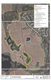
<strong>Mill</strong> Run Tr<strong>ai</strong>l<br />
The <strong>Mill</strong> Run Tr<strong>ai</strong>l sits on the original 1895<br />
r<strong>ai</strong>lbed <strong>of</strong> the “Galt, Preston, and Hespeler<br />
Street Electric R<strong>ai</strong>lway” which was opened<br />
between Preston Junction Station (located<br />
at the King St. entrance to Riverside Park)<br />
and Hespeler in January 1896. Preston<br />
Junction Station <strong>of</strong>fered frequent<br />
connections to Galt, Berlin (Kitchener) and<br />
Waterloo.<br />
A MILL RUN is the channel for a flow <strong>of</strong><br />
water that powers the water wheel in a<br />
watermill. Along this tr<strong>ai</strong>l you will view 3<br />
mill runs. This 6.5km tr<strong>ai</strong>l provides a link<br />
between Riverside Park and Jacob’s<br />
Landing.<br />
Riverside Park entrance gate is a replica <strong>of</strong><br />
the original 1921 design that was a<br />
memorial to the local men who died in<br />
World War I.<br />
A paved tr<strong>ai</strong>l leads to the pedestrian bridge<br />
over the Speed River. While on the bridge,<br />
look over the downstream r<strong>ai</strong>ling to view<br />
the rem<strong>ai</strong>ns <strong>of</strong> the dam, and mill race, that<br />
provided the water power for Pattison’s <strong>Mill</strong>.<br />
Produced by <strong>Cambridge</strong> Tr<strong>ai</strong>ls Advisory Committee<br />
For more information call 519.740.4681 ext. 4275<br />
e-m<strong>ai</strong>l tr<strong>ai</strong>ls@cambridge.ca or visit www.cambridge.ca<br />
4<br />
5<br />
Speedsville Road was the m<strong>ai</strong>n street <strong>of</strong><br />
the hamlet <strong>of</strong> Speedsville. Joseph Witmer<br />
moved here around 1842 and<br />
constructed 2 dams, a mill race, a p<strong>ai</strong>l<br />
factory and a general store. The<br />
Speedsville Woolen <strong>Mill</strong> produced yarns,<br />
blankets, tweeds and flannels into the<br />
1870s.<br />
In 1827 John Galt traveled north along<br />
Speedsville Road to found the <strong>City</strong> <strong>of</strong><br />
Guelph. The ‘ford’ at this location made<br />
crossing the river easy, and it was the<br />
stage coach route until the 1880’s. In<br />
1860 a timber bridge was constructed.<br />
You have a 1km walk to reach the<br />
footbridge under highway 401.<br />
200m north <strong>of</strong> the highway, close your<br />
eyes and imagine that you are in the long<br />
vanished Idylwild Park. O.A. Kummer<br />
gives the following description <strong>of</strong> the<br />
park: “a wooded area with tall elms,<br />
maples and evergreens – a perfect<br />
setting for one <strong>of</strong>, if not the most popular<br />
playground, picnic and recreational<br />
centre in the district. Popular dances <strong>of</strong><br />
the time included quadrilles, waltzes,<br />
two-steps and the cake walk. It was not at<br />
all uncommon for the r<strong>ai</strong>lway to shunt in<br />
from Preston Junction a tr<strong>ai</strong>n load <strong>of</strong><br />
picnickers from as far away as Hamilton<br />
bringing hundreds to enjoy the great<br />
out-<strong>of</strong>-doors in the wilds <strong>of</strong> Idylwild.”<br />
Idylwild opened in 1899 and closed in<br />
1916, never to open ag<strong>ai</strong>n.<br />
6<br />
7<br />
8<br />
9<br />
10<br />
Beaverdale was once the site <strong>of</strong> a r<strong>ai</strong>lway<br />
station – a simple wooden shed situated<br />
near the existing kiosk. Beaverdale Rd. was<br />
named after the hamlet that grew up<br />
around the buildings <strong>of</strong> Squire William Ellis.<br />
Born in Ireland, he first moved to<br />
Pennsylvania and then to Upper Canada in<br />
1810. At Beaverdale Rd., the tr<strong>ai</strong>l changes<br />
to the other side <strong>of</strong> the river.<br />
The rem<strong>ai</strong>ning tr<strong>ai</strong>l runs through fields and<br />
forests. The 80m boardwalk and 22m Ellis<br />
Creek bridge were community projects.<br />
Soon after crossing over Ellis (Chilligo)<br />
Creek, listen for the roar <strong>of</strong> the mill race<br />
outlet at the Silknit Dam. In 1864 a stone<br />
woolen mill was constructed and<br />
eventually became Forbes <strong>Mill</strong>. Fire<br />
destroyed most <strong>of</strong> the original mill. The tr<strong>ai</strong>l<br />
runs along the top <strong>of</strong> the earthen mill pond<br />
dike.<br />
After a brief walk along Sheffield St. and<br />
Guelph Ave., you will see the square tower<br />
<strong>of</strong> the site <strong>of</strong> Jacob Hespeler’s 1847 grist<br />
mill dam. Welcome to Jacob’s Landing.<br />
Cross Guelph Ave. and walk along the tr<strong>ai</strong>l<br />
leading to the Hespeler mill pond dam. The<br />
original mill race would have been across<br />
the dam. The tr<strong>ai</strong>l continues 800m along<br />
the earthen dike built to create the mill<br />
pond. The dike provides an excellent view<br />
<strong>of</strong> old Hespeler.<br />
<strong>Cambridge</strong>, Ontario, Canada