Arctron 3 D
Arctron 3 D
Arctron 3 D

You also want an ePaper? Increase the reach of your titles
YUMPU automatically turns print PDFs into web optimized ePapers that Google loves.
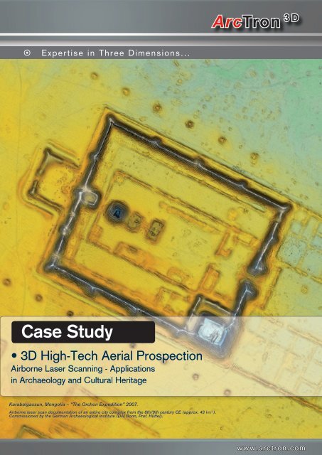
� Expertise in Three Dimensions...<br />
Case Study<br />
3D High-Tech Aerial Prospection<br />
• Airborne Laser Scanning - Applications<br />
in Archaeology and Cultural Heritage<br />
Karabalgassun, Mongolia – “The Orchon Expedition” 2007.<br />
Airborne laser scan documentation of an entire city complex from the 8th/9th century CE (approx. 43 km2 ).<br />
Commissioned by the German Archaeological Institute (DAI Bonn, Prof. Hüttel).<br />
ArcTron 3D<br />
www.arctron.com
� 3D Reconstruction � 3D Reproduction � 3D Multimedia<br />
Airborne Laser Scanning - Applications in<br />
Archaeology and Cultural Heritage<br />
During the last 10 years, airborne laser scanning has become well established<br />
as an indispensable method of generating digital elevation models. Data models<br />
such as these form the foundation for planning projects in a diversity of fields<br />
such as the mining sector, water management, road construction and urban development.<br />
In archaeology, this prospection method has only come into systematic use<br />
within the last few years and has revolutionised the task of source data retrieval.<br />
Terrain scanning enables detailed images of relatively large areas of landscape<br />
to be generated in very little time. Eroded features which survive only as<br />
low protrusions, such as settlements, ditch and rampart systems, tumuli, ancient<br />
pathways or field borders, can be identified in the scan data. The high penetration<br />
depth of laser scanning enables vegetation, in particular trees, to be filtered<br />
out of the scans allowing historical sites hidden in wooded areas to be accurately<br />
pinpointed.<br />
The emergence of this technology has signified a revolution in the recording of<br />
prehistoric and historic feature landscapes in forests. This huge advancement<br />
can perhaps be likened to that occasioned by archaeological aerial photography<br />
in the 70s.<br />
The ArcTron 3D archaeologists, engineers and data analysts use their expert<br />
knowledge of heritage issues and specialist software solutions to generate highprecision<br />
surface models. During this process, previously-known and potential<br />
or uncertain archaeological features are identified in the laser data and mapped<br />
accordingly.<br />
Vianden Castle (Luxembourg).<br />
Left: 3D visualisation of<br />
helicopter fly-over.<br />
Right: 3D terrain model in<br />
various views: With and<br />
without vegetation and<br />
buildings and with texture<br />
data from RGB aerial photogrammetry<br />
cameras.
ArcTron 3D<br />
� 3D Hardware � 3D Surveying � 3D Software Development<br />
Titelberg (Luxembourg). Celtic Oppidum (city complex) with enclosing rampart system.<br />
Top: This scaled, rectified orthophoto of the significant Celtic settlement was created using high-resolution aerial photogrammetry.<br />
Bottom: Vegetation data is filtered out for the DTM. The enclosing ramparts – i.e. the collapsed hillfort walls – usually hidden under the trees, can be very plainly<br />
seen in this model. Of further note are the many deep grooves in the ground. These proved to be collapsed mining galleries caused by iron ore extraction<br />
(19th /20th century). Alterations in the mountain’s structure can damage preserved archaeological material. Re-scanning the area at intervals of several years<br />
allows such changes to be reliably monitored.<br />
www.arctron.com
� 3D Reconstruction � 3D Reproduction � 3D Multimedia<br />
Technical Principle<br />
In airborne laser scanning, scanning systems are integrated into aeroplanes, helicopters<br />
or – as in our newly-developed cost-effective and flexible system for<br />
archaeology and heritage – into a microlite paraglider.<br />
Objects and terrain are recorded by emitting a fan of pulsed laser beams at specific<br />
intervals. Current instruments send and receive up to 160 000 laser<br />
measurements per second. The pulsed laser installed in the aircraft uses a rapidly<br />
rotating mirror to scan strips of terrain which lie perpendicular to the direction<br />
of flight and which can be up to several hundred meters wide. The laser beams<br />
are reflected by the Earth’s surface, vegetation or man-made structures.<br />
In this way, hundreds of millions of points can be surveyed in a very short time.<br />
Measurements are made at the speed of light, namely, the time-of-flight difference<br />
between the emitted and reflected laser beam.<br />
Determining the exact position and angle of each individual laser impulse is a<br />
complex task. It is achieved using a combination of two very different technologies;<br />
inertial navigation (autonomous, spatial angle definition) and satellite navigation<br />
(GPS – Global Positioning System, localisation using a network of satellites).<br />
During post-processing, angle and time-of-flight calculations are used to separate<br />
captured laser data into individual points with 3D world coordinates.<br />
ALS technology can be integrated<br />
into a variety of aircraft.<br />
For archaeology and heritage<br />
tasks, however, only helicopter<br />
and microlite aerial surveys are<br />
really suitable, due to the higher<br />
point density they achieve.
� 3D Reconstruction � 3D Reproduction � 3D Multimedia<br />
Seamless Data Models<br />
In the next stage of processing, a seamless model is generated from the separate<br />
scan strips.<br />
•<br />
•<br />
Relative calibration (alignment of elevation differences): Neighbouring flight<br />
strips must correspond exactly in position and elevation. Depending on the<br />
times at which the recordings were made, differences in GPS satellite constellations<br />
can lead to considerable errors of position and elevation. Neighbouring<br />
strips must, therefore, be inspected and adjusted where necessary,<br />
particularly if they have been recorded at significant intervals.<br />
Vianden Castle (Luxembourg).<br />
Left: This 3D terrain model, generated from airborne laser scan data, has been blended with additional terrestrial laser scan data<br />
Right: High-resolution 3D orthophotos of surveyed monuments can also be generated as a final result.<br />
Conversion of individual flight strips into a regular grid and determination<br />
of the final grid width: To do this, a tight, rectangular grid with variable grid<br />
width (0.25m–100m) is created from the laser measurement values. The<br />
high penetration of vegetation-covered areas allows two separate, surfaceconsistent,<br />
high-precision digital elevation models to be produced:<br />
• DSM (Digital Surface Model): Surface model with vegetation and<br />
buildings<br />
• DTM (Digital Terrain Model): Ground model without vegetation or<br />
buildings
� 3D Reconstruction � 3D Reproduction � 3D Multimedia<br />
Recording Elevation Data<br />
Modern laser scanners perform up to 160 000 distance measurements per<br />
second. The survey point density is constant, subject to system configuration,<br />
selected altitude and flight speed. Depending on the aircraft in use, approximately<br />
4 laser points (aeroplane) or 10-15 points (helicopter) are measured per<br />
square metre. It is also possible to measure up to 50 points per square metre for<br />
special tasks. This high survey density ensures that even fairly small structures<br />
such as drainage ditches or surface fractures can be reliably recognised.<br />
Moreover, the high density of data guarantees that building contours can be<br />
localised extremely accurately. A standard terraced house with an 80m 2 footprint<br />
would be recorded using around 400-800 measurements and described<br />
by 80-160 elevation values in a 1m grid.<br />
Currently, digital elevation models generated from airborne laser scanning data<br />
are created with grid widths of 1m or better and vertical resolutions approaching<br />
the sub-decimetre range. The models’ horizontal positional accuracy is better<br />
than ±0.2m (for every point) and the absolute vertical accuracy (referenced to<br />
the local geoid) better than ±0.15m (valid for 95.7% of all grid values).<br />
Vianden Castle (Luxembourg). 3D models (DTM/DSM).<br />
The scanner data is processed to produce elevation models which precisely describe<br />
the terrain’s surface (top edge of vegetation, roofs etc.). Elevation<br />
models of this kind are often referred to as DSMs or Digital Surface Models. In a<br />
further stage of processing, taller vegetation and buildings are automatically removed<br />
on computer, producing elevation models of the Earth’s surface, known<br />
as DTMs or Digital Terrain Models.
ArcTron 3D<br />
� 3D Hardware � 3D Surveying � 3D Software Development<br />
Basic Data Processing<br />
Post processing of the scanned data is carried out in a number of stages, some<br />
automatic and some manual. The complexity and duration of data processing<br />
depends on the size of the project and the desired results:<br />
•<br />
•<br />
•<br />
•<br />
•<br />
Synchronisation of laser data and INS/(D)GPS positional data using the<br />
GPS time stamps (UTC) present in both datasets.<br />
Data reduction: When surveying with high scanning frequencies, adjacent<br />
scan strips lie only around 0.1m apart in the direction of flight. Therefore,<br />
the data is now inspected for incorrect measurements and reduced<br />
using statistical procedures and plausibility checks. The type of reduction<br />
employed (first or last pulse) depends on the intended application: If exact<br />
terrain models (DTM) are required, higher distances are selected; for<br />
surface models (DSM) on the other hand, lower distance measurements<br />
are selected. For specialist evaluations (e.g. texture analysis),data reduction<br />
can be omitted from this phase.<br />
Geocoding: The positions of reflecting objects on the Earth’s surface are<br />
calculated from the time-of-flight difference and the position and orientation<br />
of the sensor. The results are transferred into the target coordinate system<br />
with simultaneous geoid correction. All survey data is then available in the<br />
desired coordinate system ( e.g. Gauss Krueger, meridian line 9°, Bessel<br />
Ellipsoid, Potsdam Datum, NAP).<br />
Further coordinate transformations: If no general transformation parameters<br />
are available, local transformation parameters can be calculated using<br />
at least seven known points. These points must be known in both WGS84<br />
and the local coordinate system.<br />
The result of this procedure is an ASCII file (xyz values) containing the<br />
measured elevations of every survey strip as metric target coordinates.<br />
www.arctron.com
ArcTron 3D<br />
� 3D Hardware � 3D Surveying � 3D Software Development<br />
Aerial Survey<br />
Areas selected for surveying are flown over and scanned in<br />
a pattern of parallel strips, overlapping perpendicular to the<br />
direction of flight. All the data required for subsequent evaluation<br />
is recorded during this process. During aerial surveys,<br />
the data detected by all system sensors (GPS, INS,<br />
laser scanner, RGB camera) is recorded simultaneously.<br />
Differential GPS data is recorded by at least one ground<br />
station for subsequent reconstruction of the exact flight<br />
path.<br />
Karabalgassun, Mongolia “The Orchon Expedition” 2007.<br />
Left: An MI 8 helicopter was used for aerial surveying. Right: FH Karlsruhe (technical college) provided GPS reference values using a ground station.<br />
Karabalgassun, Mongolia. “The Orchon Expedition” 2007. Various views of the city’s central area with the palace and temple complex.<br />
The remaining above-ground structures were badly eroded but could be accurately filtered and extracted from the 3D data.<br />
www.arctron.com
ArcTron 3D<br />
� 3D Hardware � 3D Surveying � 3D Software Development<br />
Filtering Data to Generate 3D Terrain<br />
Models<br />
The result, at this stage in processing, is a precise surface model (DSM) in the<br />
target coordinate system and with the target grid size (usually a 1m grid).<br />
In densely-wooded areas, however, the DSM will still contain residual vegetation<br />
and buildings which would have to be removed to generate a terrain model<br />
(DTM). If required, the DSM can be refined to produce a DTM.<br />
Vianden Castle (Luxembourg). Technical principle.<br />
During laser scanning, some laser beams will reach the ground allowing a terrain model to be generated.<br />
Aerial surveys of forested areas are mostly carried out in periods of reduced vegetation to guarantee the best<br />
results.<br />
One of several methods can be used to remove residual vegetation and buildings,<br />
depending on local circumstances. It should be mentioned that, as a rule,<br />
low-growing vegetation (lower than 1.5m) is very difficult to differentiate automatically<br />
from natural surface effects. Generally, around 80% of vegetation can<br />
be automatically removed using filter algorithms, the remainder must be re-<br />
moved interactively during post-processing.<br />
www.arctron.com
� 3D Reconstruction � 3D Reproduction � 3D Multimedia<br />
Additional Data Products<br />
Further data products can be derived from digital elevation models generated<br />
using airborne laser scanning, including:<br />
•<br />
•<br />
•<br />
•<br />
•<br />
•<br />
•<br />
•<br />
Scaled, georeferenced cross sections of any length (approx. 200 sections<br />
per hour)<br />
Variable digital grids: 1 m, 2 m, ... 5 m, ... 10 m etc. for rapid data viewing<br />
and editing<br />
Simulations of rising water levels (e.g. in meter intervals)<br />
Calculations of isolines with variable intervals (e.g. 0.1m, 0.5m, 1m …)<br />
Calculations of volume & mass with variable planning horizons<br />
Monitoring and industrial safety surveillance<br />
Efficiency control<br />
Planning data and environmental impact analysis for authorisation<br />
procedures etc.<br />
Clemency (Luxembourg).<br />
Airborne laser scan data from a previously-unknown group of Iron Age tumuli. The badly-eroded tumuli lie in a forested area (left). They are marked with three<br />
white points (in the top right of the picture).Their large diameters (> 20m) and low height (< 0.5m) make them almost unrecognisable, even on site in the forest.<br />
In the coloured, finely-graduated evaluation, however, (bottom right) they are immediately apparent (yellow). After the tumuli group was discovered during air-<br />
borne laser scanning, an archaeological excavation led by Dr. Jeannot Metzler provided evidence of an early Iron Age barrow cemetery.<br />
Bottom right graphic: Dr. Andreas Schäfer, University of Jena, Chair of prehistory and early history.
ArcTron 3D<br />
� 3D Hardware � 3D Surveying � 3D Software Development<br />
Specialist Archaeological Analysis<br />
ArcTron 3D specialises not only in archaeological research and services but<br />
also in the analysis of terrain models according to archaeological criteria. Our<br />
historical scientists, IT specialists and engineers work hand in hand to extract,<br />
analyse and structure evidence of archaeological remains from scan data. The<br />
application of full waveform filters, which analyse the entire spectrum of<br />
airborne laser scanners, enables us to produce excellent results, especially in<br />
heavily forested areas.<br />
Aalen-Wasseralfingen (Baden-Wuerttemberg, Germany).<br />
Documentation of a Hallstatt era barrow cemetery. Left: DSM (Digital Surface Model) located in light to heavy deciduous forest. Centre: DTM (Digital Terrain Model)<br />
without vegetation. Right: Plan interpretation. The tumuli threatened by building measures were subsequently excavated by LAD Baden-Wuerttemberg (Dr. Krauße).<br />
During archaeological plan evaluation and mapping, existing information is combined<br />
with new survey data. Areas in which archaeological features are suspected<br />
can be targeted and systematically searched in the plans. Archaeological<br />
features identified and potentially-identified in the data are extracted by trained<br />
engineers and prepared for on-site inspection, if required. The data is then converted<br />
into standardised GIS/CAD maps.<br />
For larger ALS projects, we also provide easy-to-use 3D software. This application<br />
allows terrain model data to be accessed rapidly and easily and provides<br />
further functions such as distance measurement, area calculation, generation of<br />
cross sections through identified objects, printouts of detailed plans and visualisation<br />
of superelevated 3D models.<br />
ArcTron 3D have carried out a broad range of diverse projects for numerous<br />
clients and developed new standards for the archaeological evaluation of ALS<br />
data.<br />
www.arctron.com
� 3D Surveying & Software Development Consultants<br />
A Selection of Project References...<br />
Archaeological airborne laser scanning projects. Since 2005, we have carried out circa 50<br />
projects in the field of archaeology and cultural heritage. Please ask us for a complete list of<br />
references.<br />
Vianden Castle (Luxembourg)<br />
Area investigated: approx. 16 km 2<br />
Bernstorf near Freising (Bavaria)<br />
Area investigated: approx. 16 km 2<br />
Ipf (Baden-Wuerttemberg)<br />
Area investigated: approx. 12 km 2<br />
Bartholomaeberg – Silbertal –<br />
Gaflunatal, Montafon (Austria)<br />
Area investigated: approx. 20 km 2<br />
Roman Limes (Bavaria, Baden-Wuerttemberg)<br />
and Odenwaldlimes (Hesse)<br />
Total length: approx. 230 km<br />
Karabalgassun, Mongolia<br />
Area investigated: approx. 43 km 2<br />
ArcTron<br />
ArcTron 3D GmbH<br />
Ringstrasse 8<br />
D-93177 Altenthann<br />
Germany<br />
Tel.: +49 9408 8501 0<br />
Fax: +49 9408 8501 21<br />
Email: info@arctron.de<br />
Web: www.arctron.com<br />
The historical landscape surrounding Vianden Castle, topography of<br />
the castle mountain, ancient path system and numerous further<br />
features. Combined with terrestrial laser scan recordings. EU-funded<br />
research project.<br />
Bronze Age hillfort settlement with medieval staggered fortification and<br />
surrounding archaeological landscape. Commissioned by: Kranzberg<br />
borough and the University of Frankfurt a.M<br />
Baden- Wuerttemberg’s “holy mountain”. A prehistoric hillfort with<br />
complex rampart structures. Evaluation of existing aerial survey data<br />
from the public surveying authority.<br />
Commissioned by: Baden-Wuerttemberg heritage authorities.<br />
Prehistoric hillfort and evidence of mining (galleries, shafts, waste<br />
heaps). Combined with terrestrial laser scan recordings.<br />
Commissioned by: University of Frankfurt a.M. - Montafon Research<br />
Project (Prof. Krause).<br />
Complete helicopter aerial survey and evaluation of the world<br />
heritage site. Documentation of the Roman limes structure, peripheral<br />
watch towers and fort complexes. Project duration 2007-2009.<br />
Commissioned by: Heritage authorities in Bavaria, Hesse and Baden-<br />
Wuerttemberg.<br />
ALS documentation of an 8th/9th century CE city complex in the<br />
Mongolian grass steppe. Commissioned by: The German Archaeological<br />
Institute ( DAI Bonn, Prof. Hüttel).<br />
Our partners for airborne laser<br />
scanning: