Recycling Treated Municipal Wastewater for Industrial Water Use
Recycling Treated Municipal Wastewater for Industrial Water Use Recycling Treated Municipal Wastewater for Industrial Water Use
Section 3 Inventory of Major WWTPs and Potential Industrial Reuse Demands Craddock Consulting Engineers 3-35 In Association with CDM & James Crook WWReuseTM1_Sec 3_final.doc WATER USE (MGD) 0.8 0.7 0.6 0.5 0.4 0.3 0.2 0.1 0 244 248 USE CODE Ground Water Surface Water 244 Sand and Gravel Washing 248 Non-Metallic Processing Figure 3.16a. Industrial Processing Water Use in the St. Croix Watershed, 2004 WATER USE (MGD 350 300 250 200 150 100 50 0 225 USE CODE Source: MDNR, 2004 Surface Water 225 Steam Power Other than Cooling Figure 3.16b. Power Generation Water Use in the St. Croix Watershed, 2004 Source: MDNR, 2004
Section 3 Inventory of Major WWTPs and Potential Industrial Reuse Demands WWTPs There are two municipal WWTPs in this watershed with design capacities greater than 1 mgd: Chisago Lakes Joint STC and Metro Council’s St. Croix Valley WWTP. Table 3.16b summarizes the design capacity and historic flows for the plant. These WWTPs discharged 3.9 mgd in 2005. There are also smaller WWTPs that discharge to surface waters with a combined design capacity of 5.2 mgd. Table 3.16b. WWTPs in the St. Croix River Watershed Facility Name Design Capacity, mgd 2005 Ann Avg Flow, mgd Flow as % of Design Capacity Chisago Lakes Joint STC Met Council - St Croix Valley 1.26 0.756 60.0% WWTP 4.5 3.126 69.5% Total Source: MPCA, 2005 5.76 3.882 67.4% Industries and Proximity to WWTPs Figure 3.16c presents the location of the industries and WWTPs in the St. Croix River watershed. Table 3.16c lists the various industries and their distance from the closer of the two WWTPs. The sand and gravel companies are all located a considerable distance from a WWTP, the closest is 5 miles away. Andersen Corporation, which used approximately 0.6 mgd of ground water in 2004, is within 1 mile of the Met Council St. Croix Valley WWTP. The Xcel Energy facility is also within 1 mile of this WWTP. Factors Influencing Potential for Industrial Reuse This watershed resides in Ground Water Area 1 of the state, which has a good bedrock aquifer supply and moderate bearing surficial sand and buried sand aquifers. As development continues around the metro area, supply pressures will be placed on ground water resources in the metro area and fringe areas to the north. Water quality has not been an issue, in general, for this area. The St. Croix supply as a surface water is superior to other major waterways of the area. Low-level contamination of upper aquifers has occurred from spills and general effects of urbanization. Areas developing with private individual sewage treatment systems (ISTSs) or clustered systems have the increased risk of nitrate and pathogen contamination. Rapid population growth and accompanying land-use changes have affected the water resources of the St. Croix River Basin. The St. Croix Basin Water Resources Planning Team (St. Croix Basin Team), working with recently completed nutrient and sediment research, has recommended a 20-percent reduction in total phosphorus loading within the St. Croix Basin. This is based on a 39-percent projected population growth in the St. Croix Basin by the year 2020. The St. Croix basin will also be part of the Lake Pepin TMDL which is projected to require a 50% reduction in solids and phosphorus loads from upstream sources. 3-36 Craddock Consulting Engineers In Association with CDM & James Crook WWReuseTM1_Sec 3_final.doc
- Page 114 and 115: Section 2 Implementation Considerat
- Page 116 and 117: Section 2 Implementation Considerat
- Page 118 and 119: Craddock Consulting Engineers 3-1 I
- Page 120 and 121: Section 3 Inventory of Major WWTPs
- Page 122 and 123: Section 3 Inventory of Major WWTPs
- Page 124 and 125: Figure 3.6. Industrial Reuse Custom
- Page 126 and 127: Section 3 Inventory of Major WWTPs
- Page 128 and 129: Figure 3.7b. Ground Water Availabil
- Page 130 and 131: Section 3 Inventory of Major WWTPs
- Page 132 and 133: ") Figure 3.8c. Cedar River Watersh
- Page 134 and 135: Section 3 Inventory of Major WWTPs
- Page 136 and 137: Section 3 Inventory of Major WWTPs
- Page 138 and 139: Section 3 Inventory of Major WWTPs
- Page 140 and 141: ") ") ") ") Figure 3.10c. Lower Mis
- Page 142 and 143: Section 3 Inventory of Major WWTPs
- Page 144 and 145: Section 3 Inventory of Major WWTPs
- Page 146 and 147: Section 3 Inventory of Major WWTPs
- Page 148 and 149: Section 3 Inventory of Major WWTPs
- Page 150 and 151: Section 3 Inventory of Major WWTPs
- Page 152 and 153: Figure 3.12c. Mississippi River - H
- Page 154 and 155: Section 3 Inventory of Major WWTPs
- Page 156 and 157: Section 3 Inventory of Major WWTPs
- Page 158 and 159: Figure 3.14b. Rainy River Watershed
- Page 160 and 161: Section 3 Inventory of Major WWTPs
- Page 162 and 163: Section 3 Inventory of Major WWTPs
- Page 166 and 167: ") Figure 3.16c. St. Croix River Wa
- Page 168 and 169: Section 3 Inventory of Major WWTPs
- Page 170 and 171: Section 3 Inventory of Major WWTPs
- Page 172 and 173: Section 3 Inventory of Major WWTPs
- Page 174 and 175: Figure 3.18 Metro Area Industrial R
- Page 176 and 177: Section 3 Inventory of Major WWTPs
- Page 178 and 179: G G Flying Cloud Dr !! G! G Figure
- Page 180 and 181: Section 3 Inventory of Major WWTPs
- Page 182 and 183: Figure 3.22. Rogers WWTP - Industri
- Page 184 and 185: Section 3 Inventory of Major WWTPs
- Page 186 and 187: G G G! Dodd Rd GG Figure 3.24. Rose
- Page 188 and 189: Section 3 Inventory of Major WWTPs
- Page 190 and 191: G Figure 3.26. Hastings WWTP - Indu
- Page 192 and 193: State Hwy 36 ! Figure 3.28. St. Cro
- Page 194 and 195: Section 3 Inventory of Major WWTPs
- Page 196 and 197: Section 3 Inventory of Major WWTPs
- Page 198 and 199: Craddock Consulting Engineers In As
- Page 200 and 201: Water Use Code Categories Minnesota
- Page 202 and 203: Minnesota Water Use for All Categor
- Page 204 and 205: Air Conditioning 0.2% Waterworks 15
- Page 206 and 207: Minnesota Water Use, 2000-2004 - St
- Page 208 and 209: Minnesota Water Use in 2004 (withou
- Page 210 and 211: Minnesota Water Use in 2000 (withou
- Page 212 and 213: UseCode by Year Minnesota Power Gen
Section 3<br />
Inventory of Major WWTPs and Potential <strong>Industrial</strong> Reuse Demands<br />
WWTPs<br />
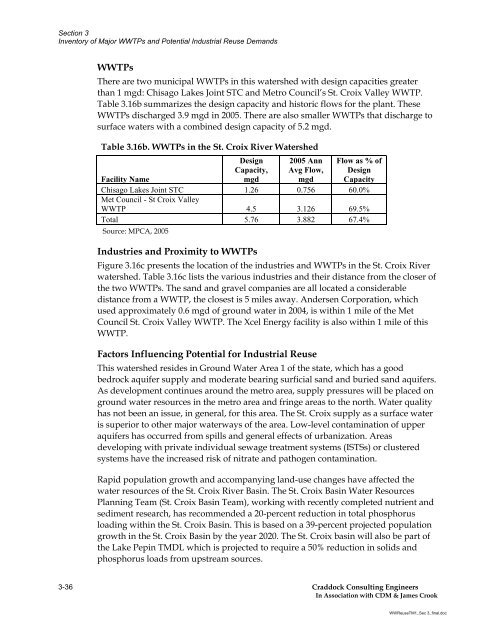
There are two municipal WWTPs in this watershed with design capacities greater<br />
than 1 mgd: Chisago Lakes Joint STC and Metro Council’s St. Croix Valley WWTP.<br />
Table 3.16b summarizes the design capacity and historic flows <strong>for</strong> the plant. These<br />
WWTPs discharged 3.9 mgd in 2005. There are also smaller WWTPs that discharge to<br />
surface waters with a combined design capacity of 5.2 mgd.<br />
Table 3.16b. WWTPs in the St. Croix River <strong>Water</strong>shed<br />
Facility Name<br />
Design<br />
Capacity,<br />
mgd<br />
2005 Ann<br />
Avg Flow,<br />
mgd<br />
Flow as % of<br />
Design<br />
Capacity<br />
Chisago Lakes Joint STC<br />
Met Council - St Croix Valley<br />
1.26 0.756 60.0%<br />
WWTP 4.5 3.126 69.5%<br />
Total<br />
Source: MPCA, 2005<br />
5.76 3.882 67.4%<br />
Industries and Proximity to WWTPs<br />
Figure 3.16c presents the location of the industries and WWTPs in the St. Croix River<br />
watershed. Table 3.16c lists the various industries and their distance from the closer of<br />
the two WWTPs. The sand and gravel companies are all located a considerable<br />
distance from a WWTP, the closest is 5 miles away. Andersen Corporation, which<br />
used approximately 0.6 mgd of ground water in 2004, is within 1 mile of the Met<br />
Council St. Croix Valley WWTP. The Xcel Energy facility is also within 1 mile of this<br />
WWTP.<br />
Factors Influencing Potential <strong>for</strong> <strong>Industrial</strong> Reuse<br />
This watershed resides in Ground <strong>Water</strong> Area 1 of the state, which has a good<br />
bedrock aquifer supply and moderate bearing surficial sand and buried sand aquifers.<br />
As development continues around the metro area, supply pressures will be placed on<br />
ground water resources in the metro area and fringe areas to the north. <strong>Water</strong> quality<br />
has not been an issue, in general, <strong>for</strong> this area. The St. Croix supply as a surface water<br />
is superior to other major waterways of the area. Low-level contamination of upper<br />
aquifers has occurred from spills and general effects of urbanization. Areas<br />
developing with private individual sewage treatment systems (ISTSs) or clustered<br />
systems have the increased risk of nitrate and pathogen contamination.<br />
Rapid population growth and accompanying land-use changes have affected the<br />
water resources of the St. Croix River Basin. The St. Croix Basin <strong>Water</strong> Resources<br />
Planning Team (St. Croix Basin Team), working with recently completed nutrient and<br />
sediment research, has recommended a 20-percent reduction in total phosphorus<br />
loading within the St. Croix Basin. This is based on a 39-percent projected population<br />
growth in the St. Croix Basin by the year 2020. The St. Croix basin will also be part of<br />
the Lake Pepin TMDL which is projected to require a 50% reduction in solids and<br />
phosphorus loads from upstream sources.<br />
3-36 Craddock Consulting Engineers<br />
In Association with CDM & James Crook<br />
WWReuseTM1_Sec 3_final.doc


