Recycling Treated Municipal Wastewater for Industrial Water Use
Recycling Treated Municipal Wastewater for Industrial Water Use Recycling Treated Municipal Wastewater for Industrial Water Use
Section 3 Inventory of Major WWTPs and Potential Industrial Reuse Demands Craddock Consulting Engineers 3-29 In Association with CDM & James Crook WWReuseTM1_Sec 3_final.doc Table 3.14a. Industrial Water Use in the Rainy River Watershed 2004 Water Use, mgd Industry Category Ground Water Surface Water Total Mine Processing 0.00 0.01 0.01 Pulp and Paper Processing 0.07 46.70 46.77 Sand and Gravel Washing 0.00 0.14 0.14 Total 0.07 46.85 46.92 Source: MDNR, 2004 WATER USE (MGD 50 45 40 35 30 25 20 15 10 5 0 242 243 USE CODE 244 Ground Water Surface Water 242 Pulp and Paper Processing 243 Mine Processing 244 Sand and Gravel Washing Figure 3.14a. Industrial Processing Water Use in the Rainy River Watershed, 2004 Source: MDNR, 2004 WWTPs There are two municipal WWTPs in this watershed with design capacities greater than 1 mgd: NKASD in International Falls and the Ely WWTP. Table 3.14b summarizes the design capacity and historic flows for the plants. These WWTPs discharged nearly 2 mgd in 2005. There are also several smaller WWTPs that discharge to surface waters with a combined design capacity of 3.3 mgd. This compares to a total WWTP capacity of 7.1 mgd for the watershed. Depending on the location of the industry it is possible that a smaller WWTP could provide an adequate reclaimed water supply.
Section 3 Inventory of Major WWTPs and Potential Industrial Reuse Demands Table 3.14b. WWTPs in the Rainy River Watershed Design Capacity, 2005 Ann Avg Flow as % of Facility Name mgd Flow, mgd Design Capacity NKASD WWTP 2.3 1.264 55.0% Ely WWTP 1.5 0.688 45.9% Total 3.8 1.952 51.4% Source: MPCA, 2005 Industries and Proximity to WWTPs The largest industry is located in International Falls and in close proximity (2.3 miles) to the WWTP, as shown on Figure 3.14c. There are no industries in Ely that have their own water permits. Table 3.14c. Industries in the Rainy River Watershed 2004 Distance to Water WWTP, Closest Industry Name Source* Use, mgd miles WWTP Industry Category UNITED STATES STEEL CORP S 0.010 >10 Ely Mine Processing S Pulp and Paper BOISE WHITE PAPER LLC 46.684 2.3 NKASD Processing S Pulp and Paper KNAEBLE TIMBER INC 0.018 >10 NKASD Processing Pulp and Paper POTLATCH CORPORATION G 0.067 >10 Ely Processing Sand and Gravel SEPPI BROS CONCRETE * G=Ground Water; S=Surface Water Source: MDNR, 2004 S 0.136 >10 Ely Washing Factors Influencing Potential for Industrial Reuse Ground water supplies are limited in the central and eastern portions of the Rainy River watershed. This area is Ground Water Area 3 and is dominated by glacial aquifers that are commonly thin and limited in their extent and yield. The bedrock aquifers also have limited yield; there are no large-scale regional aquifers. Ground water movement in much of the area is difficult to define because of the fractured nature of the bedrock. In the west (Area 4) and north (Area 5) portions of the watershed, the ground water supply in the surficial aquifers are less shallow and have moderate to good yields. This area can be dominated by connections to wetlands and contamination of surface aquifers has occurred. However, overall this watershed has a lowest to low susceptibility to contamination index, except along the southern border and interspersed areas in the watershed. 3-30 Craddock Consulting Engineers In Association with CDM & James Crook WWReuseTM1_Sec 3_final.doc
- Page 105 and 106: Section 2 Implementation Considerat
- Page 107 and 108: Section 2 Implementation Considerat
- Page 109: Section 2 Implementation Considerat
- Page 112 and 113: Section 2 Implementation Considerat
- Page 114 and 115: Section 2 Implementation Considerat
- Page 116 and 117: Section 2 Implementation Considerat
- Page 118 and 119: Craddock Consulting Engineers 3-1 I
- Page 120 and 121: Section 3 Inventory of Major WWTPs
- Page 122 and 123: Section 3 Inventory of Major WWTPs
- Page 124 and 125: Figure 3.6. Industrial Reuse Custom
- Page 126 and 127: Section 3 Inventory of Major WWTPs
- Page 128 and 129: Figure 3.7b. Ground Water Availabil
- Page 130 and 131: Section 3 Inventory of Major WWTPs
- Page 132 and 133: ") Figure 3.8c. Cedar River Watersh
- Page 134 and 135: Section 3 Inventory of Major WWTPs
- Page 136 and 137: Section 3 Inventory of Major WWTPs
- Page 138 and 139: Section 3 Inventory of Major WWTPs
- Page 140 and 141: ") ") ") ") Figure 3.10c. Lower Mis
- Page 142 and 143: Section 3 Inventory of Major WWTPs
- Page 144 and 145: Section 3 Inventory of Major WWTPs
- Page 146 and 147: Section 3 Inventory of Major WWTPs
- Page 148 and 149: Section 3 Inventory of Major WWTPs
- Page 150 and 151: Section 3 Inventory of Major WWTPs
- Page 152 and 153: Figure 3.12c. Mississippi River - H
- Page 154 and 155: Section 3 Inventory of Major WWTPs
- Page 158 and 159: Figure 3.14b. Rainy River Watershed
- Page 160 and 161: Section 3 Inventory of Major WWTPs
- Page 162 and 163: Section 3 Inventory of Major WWTPs
- Page 164 and 165: Section 3 Inventory of Major WWTPs
- Page 166 and 167: ") Figure 3.16c. St. Croix River Wa
- Page 168 and 169: Section 3 Inventory of Major WWTPs
- Page 170 and 171: Section 3 Inventory of Major WWTPs
- Page 172 and 173: Section 3 Inventory of Major WWTPs
- Page 174 and 175: Figure 3.18 Metro Area Industrial R
- Page 176 and 177: Section 3 Inventory of Major WWTPs
- Page 178 and 179: G G Flying Cloud Dr !! G! G Figure
- Page 180 and 181: Section 3 Inventory of Major WWTPs
- Page 182 and 183: Figure 3.22. Rogers WWTP - Industri
- Page 184 and 185: Section 3 Inventory of Major WWTPs
- Page 186 and 187: G G G! Dodd Rd GG Figure 3.24. Rose
- Page 188 and 189: Section 3 Inventory of Major WWTPs
- Page 190 and 191: G Figure 3.26. Hastings WWTP - Indu
- Page 192 and 193: State Hwy 36 ! Figure 3.28. St. Cro
- Page 194 and 195: Section 3 Inventory of Major WWTPs
- Page 196 and 197: Section 3 Inventory of Major WWTPs
- Page 198 and 199: Craddock Consulting Engineers In As
- Page 200 and 201: Water Use Code Categories Minnesota
- Page 202 and 203: Minnesota Water Use for All Categor
- Page 204 and 205: Air Conditioning 0.2% Waterworks 15
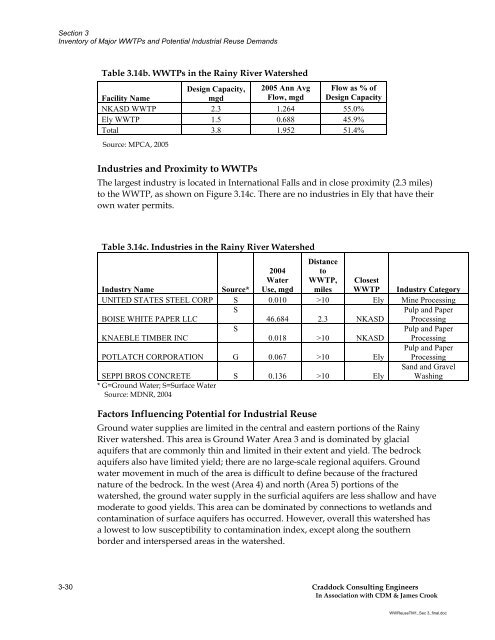
Section 3<br />
Inventory of Major WWTPs and Potential <strong>Industrial</strong> Reuse Demands<br />
Table 3.14b. WWTPs in the Rainy River <strong>Water</strong>shed<br />
Design Capacity, 2005 Ann Avg Flow as % of<br />
Facility Name<br />
mgd<br />
Flow, mgd Design Capacity<br />
NKASD WWTP 2.3 1.264 55.0%<br />
Ely WWTP 1.5 0.688 45.9%<br />
Total 3.8 1.952 51.4%<br />
Source: MPCA, 2005<br />
Industries and Proximity to WWTPs<br />
The largest industry is located in International Falls and in close proximity (2.3 miles)<br />
to the WWTP, as shown on Figure 3.14c. There are no industries in Ely that have their<br />
own water permits.<br />
Table 3.14c. Industries in the Rainy River <strong>Water</strong>shed<br />
2004<br />
Distance<br />
to<br />
<strong>Water</strong> WWTP, Closest<br />
Industry Name Source* <strong>Use</strong>, mgd miles WWTP Industry Category<br />
UNITED STATES STEEL CORP S 0.010 >10 Ely Mine Processing<br />
S<br />
Pulp and Paper<br />
BOISE WHITE PAPER LLC<br />
46.684 2.3 NKASD Processing<br />
S<br />
Pulp and Paper<br />
KNAEBLE TIMBER INC<br />
0.018 >10 NKASD Processing<br />
Pulp and Paper<br />
POTLATCH CORPORATION G 0.067 >10 Ely Processing<br />
Sand and Gravel<br />
SEPPI BROS CONCRETE<br />
* G=Ground <strong>Water</strong>; S=Surface <strong>Water</strong><br />
Source: MDNR, 2004<br />
S 0.136 >10 Ely Washing<br />
Factors Influencing Potential <strong>for</strong> <strong>Industrial</strong> Reuse<br />
Ground water supplies are limited in the central and eastern portions of the Rainy<br />
River watershed. This area is Ground <strong>Water</strong> Area 3 and is dominated by glacial<br />
aquifers that are commonly thin and limited in their extent and yield. The bedrock<br />
aquifers also have limited yield; there are no large-scale regional aquifers. Ground<br />
water movement in much of the area is difficult to define because of the fractured<br />
nature of the bedrock. In the west (Area 4) and north (Area 5) portions of the<br />
watershed, the ground water supply in the surficial aquifers are less shallow and have<br />
moderate to good yields. This area can be dominated by connections to wetlands and<br />
contamination of surface aquifers has occurred. However, overall this watershed has<br />
a lowest to low susceptibility to contamination index, except along the southern<br />
border and interspersed areas in the watershed.<br />
3-30 Craddock Consulting Engineers<br />
In Association with CDM & James Crook<br />
WWReuseTM1_Sec 3_final.doc


