RPT - ONE PAGERS - Minnesota State Legislature
RPT - ONE PAGERS - Minnesota State Legislature RPT - ONE PAGERS - Minnesota State Legislature
! ?åA@ ?åA@ ?}A@ ?ÀA@ )i ?|A@ ?òA@ ?¼A@ ?±A@ ?òA@ ?îA@ Brainerd Baxter Little Falls ?}A@ ! ?Á@ )m Sartell ?¾A@ ?ÑA@ ?¦A@ )w ?ªA@ ?ÀA@ ?¼A@ ?ªA@ ?Á@ )y ?ÉA@ ?öA@ !"b$ ?¾A@ ! Becker )m )y ?½A@ Monticello ! !"b$ ?ûA@ Saint Cloud Crosby Foley ?ØA@ )n ?¾A@ ?°A@ International Falls )n )y ?¦A@ ?|A@ ?¡A@ ?ÒA@ %&e( )y Cohasset Grand Rapids Milaca Princeton %&f( )y )i ?àA@ )q ?àA@ ?àA@ ?àA@ ?öA@ ?ÒA@ ?àA@ ?}A@ ?ÀA@ ?Á@ ?àA@ ?¼A@ ?À@ ! ! ! ! ?¾A@ %&c( ?ÒA@ ?àA@ %&h( ! ?ÖA@ !"b$ ?ÇA@ ! %&c( ?ÑA@ ?©A@ ! !"b$ ! ?æA@ ?æA@ )q ?æA@ !"`$ ?äA@ ?ñA@ %&h( !"`$ ?ÈA@ ?ÓA@ ?öA@ !"`$ )l ?àA@ Duluth Chisago City?Á@ Rockville Zimmerman Saint Augusta East Bethel ?ØA@ Elk River ?ÒA@ Annandale Otsego Columbus ?øA@ )y Scandia )m Saint Michael !"b$ ?½A@ ?³A@ ?²A@ )s %&d( ?öA@ GreenfieldDayton Blaine Hugo ?óA@ )m )n Cokato Corcoran ?ØA@ !"b$ Grant Major Highway Projects 2011 District 1 Mora Pine City ?÷A@ ?¸A@ ?ÇA@ ?lA@ ?©A@ ?öA@ ?¼A@ )q ?vA@ Mountain Iron Chisholm)y Virginia Eveleth Hibbing Rush City Moose Lake Cambridge North Branch )i ?ÅA@ !"`$ ?rA@ ?¦A@ Hoyt Lakes Hermantown Duluth Cloquet Proctor ! ?ÝA@ Ely Two Harbors ?¦A@ Silver Bay ?ÝA@ Major Highway Projects .
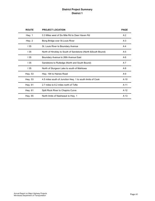
District Project Summary District 1 ROUTE PROJECT LOCATION PAGE Hwy. 1 0.3 Miles west of Six Mile Rd to Deer Haven Rd A 2 Hwy. 2 Bong Bridge over St.Louis River A 3 I 35 St. Louis River to Boundary Avenue A 4 I 35 North of Hinckley to South of Sandstone (North &South Bound) A 5 I 35 Boundary Avenue to 26th Avenue East A 6 I 35 Sandstone to Rutledge (North and South Bound) A 7 I 35 North of Sturgeon Lake to south of Mahtowa A 8 Hwy. 53 Hwy. 194 to Haines Road A 9 Hwy. 53 4.5 miles south of Junction Hwy. 1 to south limits of Cook A 10 Hwy. 61 2.7 miles to 6.2 miles north of Tofte A 11 Hwy. 61 Split Rock River to Chapins Curve A 12 Hwy. 65 North limits of Nashwauk to Hwy. 1 A 13 Annual Report on Major Highway Projects Minnesota Department of Transportation Page A1
- Page 1 and 2: This document is made available ele
- Page 3 and 4: Table of Contents Report Costs Page
- Page 5 and 6: Cost of completing this report The
- Page 7 and 8: Annual Report on Major Highway Proj
- Page 9 and 10: Highway Investment Plan Process The
- Page 11 and 12: Abbreviations to Annual Report on M
- Page 13 and 14: ANNUAL REPORT ON MAJOR HIGHWAY PROJ
- Page 15 and 16: ANNUAL REPORT ON MAJOR HIGHWAY PROJ
- Page 17: !! ! ! ! ! ! ! ! ! ! ! ! ! ! ! ! !
- Page 21 and 22: Schedule: Environmental Document Ap
- Page 23 and 24: Schedule: Environmental Document Ap
- Page 25 and 26: Schedule: Environmental Document Ap
- Page 27 and 28: Schedule: Environmental Document Ap
- Page 29 and 30: Schedule: Environmental Document Ap
- Page 31 and 32: Schedule: Environmental Document Ap
- Page 33 and 34: District Project Summary District 2
- Page 35 and 36: Schedule: Environmental Document Ap
- Page 37 and 38: Schedule: Environmental Document Ap
- Page 39 and 40: PROJECT SUMMARY Hwy. 71 3.0 miles s
- Page 41 and 42: Perham ?gA@ ?¬A@ )i ?aA@ ! ! ?ýA@
- Page 43 and 44: Schedule: Environmental Document Ap
- Page 45 and 46: Schedule: Environmental Document Ap
- Page 47 and 48: Schedule: Environmental Document Ap
- Page 49: Schedule: Environmental Document Ap
- Page 52 and 53: Schedule: Environmental Document Ap
- Page 54 and 55: PROJECT SUMMARY Hwy. 59 North of TH
- Page 56 and 57: Schedule: Environmental Document Ap
- Page 58 and 59: District Project Summary District 6
- Page 60 and 61: Schedule: Environmental Document Ap
- Page 62 and 63: Schedule: Elk Run interchange State
- Page 64 and 65: Schedule: Environmental Document Ap
- Page 66 and 67: Schedule: Environmental Document Ap
District Project Summary<br />
District 1<br />
ROUTE PROJECT LOCATION PAGE<br />
Hwy. 1 0.3 Miles west of Six Mile Rd to Deer Haven Rd A 2<br />
Hwy. 2 Bong Bridge over St.Louis River A 3<br />
I 35 St. Louis River to Boundary Avenue A 4<br />
I 35 North of Hinckley to South of Sandstone (North &South Bound) A 5<br />
I 35 Boundary Avenue to 26th Avenue East A 6<br />
I 35 Sandstone to Rutledge (North and South Bound) A 7<br />
I 35 North of Sturgeon Lake to south of Mahtowa A 8<br />
Hwy. 53 Hwy. 194 to Haines Road A 9<br />
Hwy. 53 4.5 miles south of Junction Hwy. 1 to south limits of Cook A 10<br />
Hwy. 61 2.7 miles to 6.2 miles north of Tofte A 11<br />
Hwy. 61 Split Rock River to Chapins Curve A 12<br />
Hwy. 65 North limits of Nashwauk to Hwy. 1 A 13<br />
Annual Report on Major Highway Projects<br />
<strong>Minnesota</strong> Department of Transportation<br />
Page A1


