Quantifying Uncontrolled Landfill Gas Emissions from Two Florida ...
Quantifying Uncontrolled Landfill Gas Emissions from Two Florida ...
Quantifying Uncontrolled Landfill Gas Emissions from Two Florida ...

You also want an ePaper? Increase the reach of your titles
YUMPU automatically turns print PDFs into web optimized ePapers that Google loves.
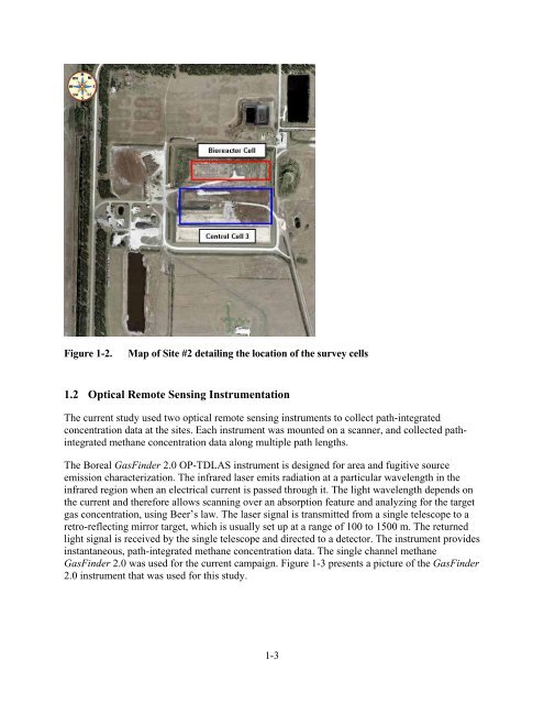
Figure 1-2. Map of Site #2 detailing the location of the survey cells<br />
1.2 Optical Remote Sensing Instrumentation<br />
The current study used two optical remote sensing instruments to collect path-integrated<br />
concentration data at the sites. Each instrument was mounted on a scanner, and collected pathintegrated<br />
methane concentration data along multiple path lengths.<br />
The Boreal <strong>Gas</strong>Finder 2.0 OP-TDLAS instrument is designed for area and fugitive source<br />
emission characterization. The infrared laser emits radiation at a particular wavelength in the<br />
infrared region when an electrical current is passed through it. The light wavelength depends on<br />
the current and therefore allows scanning over an absorption feature and analyzing for the target<br />
gas concentration, using Beer’s law. The laser signal is transmitted <strong>from</strong> a single telescope to a<br />
retro-reflecting mirror target, which is usually set up at a range of 100 to 1500 m. The returned<br />
light signal is received by the single telescope and directed to a detector. The instrument provides<br />
instantaneous, path-integrated methane concentration data. The single channel methane<br />
<strong>Gas</strong>Finder 2.0 was used for the current campaign. Figure 1-3 presents a picture of the <strong>Gas</strong>Finder<br />
2.0 instrument that was used for this study.<br />
1-3