

Slide Presentation - Door County Web Map
Slide Presentation - Door County Web Map
Slide Presentation - Door County Web Map

Create successful ePaper yourself
Turn your PDF publications into a flip-book with our unique Google optimized e-Paper software.
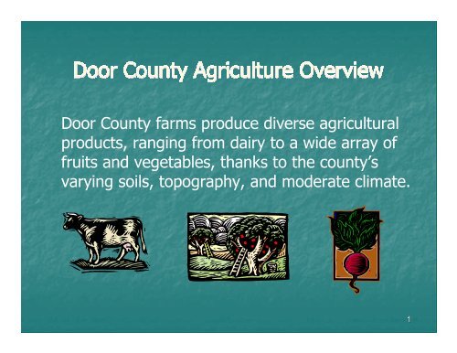
<strong>Door</strong> <strong>County</strong> farms produce diverse agricultural<br />
products, ranging from dairy to a wide array of<br />
fruits and vegetables, thanks to the county’s<br />
varying soils, topography, and moderate climate.<br />
1
Overall, total number of farms, including<br />
orchards, has trended downward, after factoring<br />
in the change in the way farms are counted.<br />
Change in the way the USDA Census of<br />
Agriculture counted farms created upward spike;<br />
horse and pony, Christmas tree, and maple<br />
syrup farms now counted.<br />
2
Losses occurring in number of mid-size farms.<br />
Between 1987 and 2007:<br />
21% increase in number of large farms (500+<br />
acres)<br />
28% decrease in number of mid-size farms (50<br />
– 499 acres)<br />
71% increase small farms or “hobby” farms (less<br />
than 50 acres)<br />
5
Both number and size of apple & cherry<br />
orchards have significantly decreased<br />
Mid-1940s, 700 cherry growers in the county; by<br />
2002, only 65 growers remained.<br />
As of 2008, approx. 60 cherry farms and 20<br />
apple farms, producing on approx. 3,000<br />
acres.<br />
6
Conversion of agricultural land to nonagricultural<br />
use in <strong>Door</strong> <strong>County</strong> exceeds eastern<br />
district and state averages.<br />
Between 2000 and 2002, 64% (yearly average)<br />
of agricultural land sold in <strong>Door</strong> <strong>County</strong><br />
converted to non-agricultural uses, compared to<br />
the state’s average of 29%.<br />
9
Loss of agricultural land coincides with the<br />
increase in seasonal and year-round population,<br />
particularly in the northern part of the county;<br />
population growth between 2000 and 2006 in<br />
north accounted for 51% of all growth in the<br />
county.<br />
Towns experiencing high population growth in<br />
northern <strong>Door</strong> <strong>County</strong> also had some of the<br />
greatest percentage declines in dairy farm<br />
numbers.<br />
10
Number of hobby farms has gone up partly due to<br />
niche agriculture in the areas of:<br />
organic and sustainable farming<br />
market farms<br />
production of landscaping trees and plants<br />
Over 80 (15 – 20%) agricultural producers that<br />
sell their products locally at roadside stands,<br />
farmers markets, or directly from<br />
the farm.<br />
11
GOAL 2: Establish and enhance local education,<br />
coordination, and funding efforts to promote<br />
agricultural preservation.<br />
GOAL 5: Preserve existing agriculture and<br />
promote more sustainable agricultural<br />
operations, providing local food sources to serve<br />
present and future generations.<br />
12
Develop local plans, ordinances, and programs<br />
to retain large, contiguous areas of prime<br />
agriculture.<br />
Support and preserve small family farms as well<br />
as low-impact and emerging agricultural<br />
operations.<br />
13
sustainable agriculture practices, such as<br />
organic certification<br />
sustainable forestry practices<br />
producing, processing, and selling crops locally<br />
allow appropriate processing and sales options<br />
on-site for agricultural uses.<br />
tap into the growing “buy local” movement.<br />
14
Revised Chapter 91 – “Working Lands Initiative” –<br />
effective July 1, 2009.<br />
New statutory definition of “Agricultural Use”:<br />
Crop or forage production (includes orchards)<br />
Keeping livestock<br />
Beekeeping<br />
Nursery, sod, or Christmas tree production; forest<br />
management<br />
Floriculture, aquaculture<br />
Fur farming<br />
Enrollment in federal agricultural commodity payment<br />
program or federal or state agricultural land<br />
conservation payment program 16
Multiple components: county farmland<br />
preservation plans; income tax credits for<br />
Exclusive Agricultural zoning and/or Agricultural<br />
Enterprise Areas; Purchase of Agricultural<br />
Conservation Easements.<br />
Conservation standard compliance required.<br />
Most components of law not effective until<br />
updated plan, maps, and ordinance developed<br />
and certified by DATCP. <strong>Door</strong> <strong>County</strong> plan must<br />
be certified by December 31, 2012.<br />
17
$5.00/acre if located in AEA only.<br />
$7.50/acre if located in EA zoning only.<br />
$10.00/acre if zoned EA and in AEA.<br />
All must:<br />
Earn at least $6,000/year in gross farm<br />
revenue (or $18,000 over 3-year<br />
period).<br />
Be in compliance with NR 151<br />
Agricultural Performance Standards.<br />
Use the land primarily for agriculture.<br />
Have paid property taxes.<br />
18
No minimum lot size mandated by state.<br />
Some non-farm development on small lots<br />
allowed, either via conditional use permit<br />
or by rezoning and paying conversion fee.<br />
Creation of small lots no longer needs to<br />
be for farm consolidation purposes or for<br />
farm workers/family residences.<br />
$7.50/acre income tax credit.<br />
19
Rezoning out of EA requires “findings findings of fact” fact and shall<br />
be “substantially substantially consistent” consistent with farmland preservation<br />
plan.<br />
Fee for rezoning lands out of EA:<br />
3 times Dept. of Revenue (DOR) Grade 1 cropland<br />
value.<br />
Example: Clay Banks Grade 1 value is $219/acre<br />
(changes yearly). $219/acre x 3 = $657/acre.<br />
Fee collected by county, sent to DOR.<br />
Owners not collecting tax credits still subject to fee.<br />
No fee for sale of land.<br />
No fee for rezoning as part of plan certification process.<br />
20
Country Road<br />
John &<br />
Mary Smith<br />
Zoned EA<br />
40 a<br />
John & Mary Smith<br />
Zoned EA<br />
20 a<br />
John & Mary Smith<br />
Purchased 20 a<br />
Zoned EA<br />
Smith<br />
Acres LLC<br />
Zoned EA<br />
40 a<br />
Base Farm Tract 2 – 40 acres<br />
Base Farm Tract 1 – 60 acres<br />
Ownership of both parcels is exactly the same<br />
Purchased land after base farm tract<br />
determined; does not change base farm tract<br />
acreage. 22
Individual and cluster developments of non-farm lots<br />
may be allowed by CUP in EA if:<br />
Ratio of non-farm lot acreage to the base farm tract<br />
acreage minus the non-farm acreage is less than 1 to<br />
20 (0.05); and<br />
No more than 4 non-farm dwelling units established<br />
on base farm tract (an additional farm residence is<br />
also allowed for each base tract); and<br />
Proposed non-farm parcel(s) will not:<br />
Convert prime farmland or cropland (other than a<br />
woodlot) from agricultural use, unless no<br />
reasonable alternative location.<br />
Significantly impair or limit the current or future<br />
agricultural use of any other protected farmland.<br />
23
Country Road<br />
John &<br />
Mary Smith<br />
40 a<br />
Zoned EA<br />
John &<br />
Mary Smith<br />
– 20 a<br />
Zoned EA<br />
Base farm tract = 60 acres<br />
1 existing farm residence<br />
Ratio of non-farm acreage to farm<br />
acreage minus non-farm acreage may<br />
not exceed 1 to 20 (0.05).<br />
DATCP formula:<br />
R (non-farm development<br />
acreage allowed) = Base farm<br />
tract acreage /21.<br />
Up to 2.85 acres of non-farm lots<br />
allowed. Could contain up to four<br />
non-farm residences.<br />
May<br />
authorize<br />
with CUP if<br />
new lots do<br />
not convert<br />
prime soils<br />
or cropland<br />
or impair/<br />
limit future<br />
agricultural<br />
use of any<br />
other<br />
protected<br />
farmland.<br />
24
Contiguous land area devoted primarily to<br />
agricultural use and locally targeted for agricultural<br />
preservation and agricultural development.<br />
AEA must be identified as preservation area in<br />
county Farmland Preservation Plan map.<br />
Application must be submitted by five or more<br />
eligible farms (land totaling at least 1,000 acres) and<br />
the local government, and be approved by DATCP.<br />
Farmers in AEAs are eligible for income tax credits<br />
($5/acre) if they enter individual, 15-year contracts<br />
with DATCP. Early contract release requires<br />
payment of conversion fee (same formula as for<br />
rezoning out of EA district).<br />
25
Pilot program underway: Approx. 12 AEAs and<br />
200,000 acres approved statewide for program start<br />
January 1, 2011.<br />
2011 applications being solicited now for 2012<br />
program start; February 18, 2011 deadline.<br />
Interested parties should also contact Coreen Fallat<br />
at coreen.fallat@wisconsin.gov or (608) 224-4625<br />
prior to submitting a petition.<br />
Petition form on DATCP website,<br />
http://www.datcp.state.wi.us/workinglands/forms.jsp.<br />
26
State will provide 50% matching grants toward<br />
PACE.<br />
Participants: landowners, non-profit<br />
organizations, local and other governments.<br />
Permanent deed restrictions, binding current<br />
and future owners.<br />
Land remains on tax rolls as agricultural land.<br />
No public access requirement.<br />
Applications solicited annually; DATCP<br />
determining selection process.<br />
27
<strong>Door</strong> <strong>County</strong> Soil & Water Conservation<br />
Department (SWCD) will review compliance for:<br />
Cropland Erosion<br />
Manure Storage Facilities<br />
Clean Water Diversion<br />
Nutrient Management<br />
Manure Management<br />
DATCP still working on processes for reporting<br />
and communication between agencies (DOR,<br />
<strong>Door</strong> <strong>County</strong> SWCD, and DATCP).<br />
28
New landowner certification requirements<br />
starting with the 2010 tax return<br />
Most landowners can work toward achieving<br />
compliance while still claiming a tax credit<br />
Counties and DATCP have new compliance<br />
monitoring responsibilities<br />
29
Which Operations Must Meet State<br />
Conservation Standards?<br />
Operations in certified<br />
agricultural zoning<br />
districts<br />
Operations with new or<br />
modified agreements<br />
signed after 2009<br />
Operations with<br />
agreements signed after<br />
~2004 (new conservation<br />
standards)
State Conservation Standards<br />
Sheet, Rill & Wind Erosion Nutrient Management
State Conservation Standards<br />
New or substantially altered<br />
manure storage<br />
Existing failing or leaking<br />
manure storage
State Conservation Standards<br />
Clean water diversions<br />
Water quality<br />
management areas<br />
Areas susceptible to<br />
groundwater<br />
contamination<br />
Within 300 feet of a<br />
navigable stream<br />
Within 1,000 feet of a<br />
lake
State Conservation Standards<br />
No overflow of manure<br />
structures<br />
No unconfined manure<br />
stacks in WQMAs
State Conservation Standards<br />
No direct runoff from feedlots or<br />
stored manure<br />
No unlimited livestock access to<br />
waters of the state
Compliance is Required for the<br />
Entire Farm<br />
All parts of the farm must be compliant with<br />
all agricultural performance standards and<br />
manure management prohibitions<br />
Does not only apply to land for which the credit is<br />
claimed<br />
Entire farm includes:<br />
Commonly owned land used as part of a single<br />
farm operation<br />
Shared/rented land for manure applications<br />
Land not in agricultural production
Landowner Responsibilities<br />
Must certify compliance to claim tax credit<br />
for CY 2010<br />
For landowners who claimed in 2009<br />
Exhibit compliance<br />
Develop a schedule to achieve compliance<br />
No later than December 31, 2015<br />
Landowners that did not claim in 2009 must<br />
certify compliance and will not be allowed to<br />
schedule compliance<br />
May amend tax return if compliance is later<br />
verified
Notice of Noncompliance<br />
Failure to comply with conservation<br />
standards<br />
Failure to permit a reasonable inspection<br />
Failure to respond to self-certification<br />
self certification<br />
requests<br />
Offer of cost-share cost share is not needed to<br />
require compliance to maintain the ability<br />
to receive tax credits
After 12/31/2012, for <strong>Door</strong> <strong>County</strong><br />
farmers to be eligible for tax credits,<br />
farmland preservation plan and map<br />
must meet state Working Lands Initiative<br />
standards and be certified by DATCP.<br />
If any EA zoning, zoning ordinance and<br />
map(s) also must be certified.<br />
Farmland preservation plan text and map<br />
must be consistent with zoning; all must<br />
be consistent with comprehensive plan.<br />
39
1. Clay Banks retains and/or other towns choose<br />
to have (some) areas zoned EA.<br />
2. Rezone all EA to a different agricultural zoning<br />
district, such as Prime Agricultural or General<br />
Agricultural.<br />
3. Pursue AEA designation(s), regardless of<br />
zoning district(s).<br />
4. Pursue PACE option, regardless of zoning<br />
district(s).<br />
5. Forego participation in formal state programs.<br />
6. Develop (other or additional) programs within<br />
the county.<br />
40
November 30, 2010: Kick-off meeting.<br />
Winter 2010-2011: Public Participation Plan,<br />
possible grant application for plan development.<br />
2011: Planning, SWCD, UWEX, and interested<br />
farmers and others develop draft plan based on<br />
comp. plans and other public input.<br />
Early 2012: Submit plan (and ordinance ?)<br />
certification application(s) to DATCP.<br />
Late 2012: <strong>County</strong> adopts final versions;<br />
county and towns amend comprehensive plan<br />
future land use maps, if necessary.<br />
Zoning ordinance amendments in place by<br />
1/1/2014. (Note: conversion fees required if<br />
EA zoning map removals not adopted “in<br />
conjunction” with plan certification.)

![A Guide to the Control and Management of Invasive Phragmites [PDF]](https://img.yumpu.com/19126786/1/190x190/a-guide-to-the-control-and-management-of-invasive-phragmites-pdf.jpg?quality=85)


![Homeowner's Guide to Japanese Knotweed Control [PDF]](https://img.yumpu.com/19126766/1/190x245/homeowners-guide-to-japanese-knotweed-control-pdf.jpg?quality=85)


