

County of Door, Wisconsin - Door County Web Map
County of Door, Wisconsin - Door County Web Map
County of Door, Wisconsin - Door County Web Map

You also want an ePaper? Increase the reach of your titles
YUMPU automatically turns print PDFs into web optimized ePapers that Google loves.
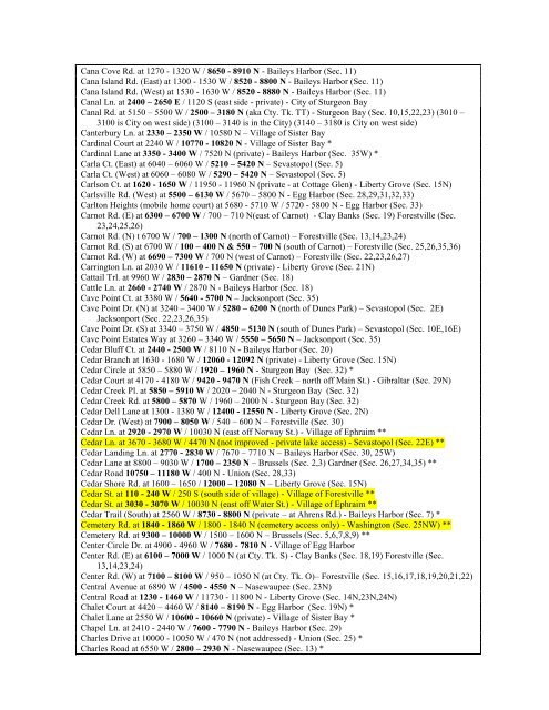
Cana Cove Rd. at 1270 - 1320 W / 8650 - 8910 N - Baileys Harbor (Sec. 11)<br />
Cana Island Rd. (East) at 1300 - 1530 W / 8520 - 8800 N - Baileys Harbor (Sec. 11)<br />
Cana Island Rd. (West) at 1530 - 1630 W / 8520 - 8880 N - Baileys Harbor (Sec. 11)<br />
Canal Ln. at 2400 – 2650 E / 1120 S (east side - private) - City <strong>of</strong> Sturgeon Bay<br />
Canal Rd. at 5150 – 5500 W / 2500 – 3180 N (aka Cty. Tk. TT) - Sturgeon Bay (Sec. 10,15,22,23) (3010 –<br />
3100 is City on west side) (3100 – 3140 is in the City) (3140 – 3180 is City on west side)<br />
Canterbury Ln. at 2330 – 2350 W / 10580 N – Village <strong>of</strong> Sister Bay<br />
Cardinal Court at 2240 W / 10770 - 10820 N - Village <strong>of</strong> Sister Bay *<br />
Cardinal Lane at 3350 - 3400 W / 7520 N (private) - Baileys Harbor (Sec. 35W) *<br />
Carla Ct. (East) at 6040 – 6060 W / 5210 – 5420 N – Sevastopol (Sec. 5)<br />
Carla Ct. (West) at 6060 – 6080 W / 5290 – 5420 N – Sevastopol (Sec. 5)<br />
Carlson Ct. at 1620 - 1650 W / 11950 - 11960 N (private - at Cottage Glen) - Liberty Grove (Sec. 15N)<br />
Carlsville Rd. (West) at 5500 – 6130 W / 5670 – 5800 N - Egg Harbor (Sec. 28,29,31,32,33)<br />
Carlton Heights (mobile home court) at 5680 - 5710 W / 5720 - 5800 N - Egg Harbor (Sec. 33)<br />
Carnot Rd. (E) at 6300 – 6700 W / 700 – 710 N(east <strong>of</strong> Carnot) - Clay Banks (Sec. 19) Forestville (Sec.<br />
23,24,25,26)<br />
Carnot Rd. (N) t 6700 W / 700 – 1300 N (north <strong>of</strong> Carnot) – Forestville (Sec. 13,14,23,24)<br />
Carnot Rd. (S) at 6700 W / 100 – 400 N & 550 – 700 N (south <strong>of</strong> Carnot) – Forestville (Sec. 25,26,35,36)<br />
Carnot Rd. (W) at 6690 – 7300 W / 700 N (west <strong>of</strong> Carnot) – Forestville (Sec. 22,23,26,27)<br />
Carrington Ln. at 2030 W / 11610 - 11650 N (private) - Liberty Grove (Sec. 21N)<br />
Cattail Trl. at 9960 W / 2830 – 2870 N – Gardner (Sec. 18)<br />
Cattle Ln. at 2660 - 2740 W / 2870 N - Baileys Harbor (Sec. 18)<br />
Cave Point Ct. at 3380 W / 5640 - 5700 N – Jacksonport (Sec. 35)<br />
Cave Point Dr. (N) at 3240 – 3400 W / 5280 – 6200 N (north <strong>of</strong> Dunes Park) – Sevastopol (Sec. 2E)<br />
Jacksonport (Sec. 22,23,26,35)<br />
Cave Point Dr. (S) at 3340 – 3750 W / 4850 – 5130 N (south <strong>of</strong> Dunes Park) – Sevastopol (Sec. 10E,16E)<br />
Cave Point Estates Way at 3260 – 3340 W / 5550 – 5650 N – Jacksonport (Sec. 35)<br />
Cedar Bluff Ct. at 2440 - 2500 W / 8110 N - Baileys Harbor (Sec. 20)<br />
Cedar Branch at 1630 - 1680 W / 12060 - 12092 N (private) - Liberty Grove (Sec. 15N)<br />
Cedar Circle at 5850 – 5880 W / 1920 – 1960 N - Sturgeon Bay (Sec. 32) *<br />
Cedar Court at 4170 - 4180 W / 9420 - 9470 N (Fish Creek – north <strong>of</strong>f Main St.) - Gibraltar (Sec. 29N)<br />
Cedar Creek Pl. at 5850 – 5910 W / 2020 – 2040 N - Sturgeon Bay (Sec. 32)<br />
Cedar Creek Rd. at 5800 – 5870 W / 1960 – 2000 N - Sturgeon Bay (Sec. 32)<br />
Cedar Dell Lane at 1300 - 1380 W / 12400 - 12550 N - Liberty Grove (Sec. 2N)<br />
Cedar Dr. (West) at 7900 – 8050 W / 540 – 600 N – Forestville (Sec. 30)<br />
Cedar Ln. at 2920 - 2970 W / 10030 N (east <strong>of</strong>f Norway St.) - Village <strong>of</strong> Ephraim **<br />
Cedar Ln. at 3670 - 3680 W / 4470 N (not improved - private lake access) - Sevastopol (Sec. 22E) **<br />
Cedar Landing Ln. at 2770 - 2830 W / 7670 – 7710 N – Baileys Harbor (Sec. 30, 25W)<br />
Cedar Lane at 8800 – 9030 W / 1700 – 2350 N – Brussels (Sec. 2,3) Gardner (Sec. 26,27,34,35) **<br />
Cedar Road 10750 – 11180 W / 400 N - Union (Sec. 28,33)<br />
Cedar Shore Rd. at 1600 – 1650 / 12000 – 12080 N – Liberty Grove (Sec. 15N)<br />
Cedar St. at 110 - 240 W / 250 S (south side <strong>of</strong> village) - Village <strong>of</strong> Forestville **<br />
Cedar St. at 3030 - 3070 W / 10030 N (east <strong>of</strong>f Water St.) - Village <strong>of</strong> Ephraim **<br />
Cedar Trail (South) at 2560 W / 8730 - 8800 N (private – at Ahrens Rd.) - Baileys Harbor (Sec. 7) *<br />
Cemetery Rd. at 1840 - 1860 W / 1800 - 1840 N (cemetery access only) - Washington (Sec. 25NW) **<br />
Cemetery Rd. at 9300 – 10000 W / 1500 – 1600 N – Brussels (Sec. 5,6,7,8,9) **<br />
Center Circle Dr. at 4900 - 4960 W / 7680 - 7810 N - Village <strong>of</strong> Egg Harbor<br />
Center Rd. (E) at 6100 – 7000 W / 1000 N (at Cty. Tk. S) - Clay Banks (Sec. 18,19) Forestville (Sec.<br />
13,14,23,24)<br />
Center Rd. (W) at 7100 – 8100 W / 950 – 1050 N (at Cty. Tk. O)– Forestville (Sec. 15,16,17,18,19,20,21,22)<br />
Central Avenue at 6890 W / 4500 - 4550 N – Nasewaupee (Sec. 23N)<br />
Central Road at 1230 - 1460 W / 11730 - 11800 N - Liberty Grove (Sec. 14N,23N,24N)<br />
Chalet Court at 4420 – 4460 W / 8140 – 8190 N - Egg Harbor (Sec. 19N) *<br />
Chalet Lane at 2550 W / 10600 - 10660 N (private) - Village <strong>of</strong> Sister Bay *<br />
Chapel Ln. at 2410 - 2440 W / 7600 - 7790 N - Baileys Harbor (Sec. 29)<br />
Charles Drive at 10000 - 10050 W / 470 N (not addressed) - Union (Sec. 25) *<br />
Charles Road at 6550 W / 2800 – 2930 N - Nasewaupee (Sec. 13) *

![A Guide to the Control and Management of Invasive Phragmites [PDF]](https://img.yumpu.com/19126786/1/190x190/a-guide-to-the-control-and-management-of-invasive-phragmites-pdf.jpg?quality=85)


![Homeowner's Guide to Japanese Knotweed Control [PDF]](https://img.yumpu.com/19126766/1/190x245/homeowners-guide-to-japanese-knotweed-control-pdf.jpg?quality=85)


