County of Door, Wisconsin - Door County Web Map
County of Door, Wisconsin - Door County Web Map
County of Door, Wisconsin - Door County Web Map
Create successful ePaper yourself
Turn your PDF publications into a flip-book with our unique Google optimized e-Paper software.
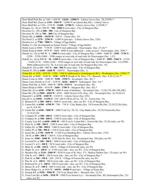
<strong>Door</strong> Bluff Park Rd. at 1360 - 1450 W / 12630 - 12900 N - Liberty Grove (Sec. 2N,35NW) *<br />
<strong>Door</strong> Bluff Rd. (East) at 1330 - 1560 W / 12600 N (at Garrett Bay Rd.) - Liberty Grove<br />
<strong>Door</strong> Bluff Rd. at 1530 - 1570 W / 12400 - 12780 N - Liberty Grove (Sec. 2,35NW) *<br />
Douglas Av. (S) at 1300 W / 700 - 1000 S (west side) - City <strong>of</strong> Sturgeon Bay<br />
Dovetree Ct.. (W) at 800 - 900 - City <strong>of</strong> Sturgeon Bay<br />
Dovetree Pl. (W) at 700 - 800 City <strong>of</strong> Sturgeon Bay<br />
Draize Rd. at 10050 – 10150 W / 630 N – Union (Sec. 25)<br />
Du Nord Ct. at 2270 – 2290 W / 11000 N (private) – Liberty Grove (Sec. 32N)<br />
Duchess Ln. at 7780 - 7800 N - Village <strong>of</strong> Egg Harbor<br />
Dudley Ct. (for development at Eames Farm) - Village <strong>of</strong> Egg Harbor<br />
Dufek Lane at 6980 – 7150 W / 2200 N (not addressed) - Nasewaupee (Sec. 27,34) *<br />
Dufek Road at 8060 - 8070 W / 4080 - 4090 N (not addressed – water access) - Nasewaupee (Sec. 30N) *<br />
Duluth Av. (N) at 900 W / 1 - 1000 N (west side) - City <strong>of</strong> Sturgeon Bay // 6400 – 6480 W / 3290 – 3730 N –<br />
(3290 – 3330) (3400 – 3508) ranges at west side <strong>of</strong> road only for Nasewaupee (Sec. 1,12)<br />
Duluth Av. (S) at 800 W / 10 - 1300 S (west side) - City <strong>of</strong> Sturgeon Bay // 6400 W / 2890 - 3260 N – (3120<br />
– 3160) (3176 – 3200) (3220 – 3250) ranges at west side <strong>of</strong> road only for Nasewaupee (Sec. 12) (2890 –<br />
3060) addressed to Cty. Tk. S at east side <strong>of</strong> road only for Sturgeon Bay (Sec. 18)<br />
Duluth Pl. (N) at 600 - 900 W / 600 - 900 N (west side) - City <strong>of</strong> Sturgeon Bay<br />
Duluth Pl. (W) at 6400 – 6440 W / 3450 N – Nasewaupee (Sec. 1)<br />
Dump Rd. at 1050 - 1070 W / 1500 - 1560 N (addressed to Gunnlaugsson Rd.) - Washington (Sec. 32NE) **<br />
Dump Rd. at 9000 – 9100 W / 1150 – 1470 N (South <strong>of</strong> St. Hwy. 57) - Brussels (Sec. 9,10,15,16) **<br />
Dunes Court at 3800 – 3840 W / 5290 – 5350 N - Sevastopol (Sec. 4E) *<br />
Dunes Lane (South) at 3110 – 3120 W / 6630 – 6660 N - Jacksonport (Sec. 14) *<br />
Dunes Park Rd. at 3450 - 3480 W / 5270 - 5310 N – Sevastopol (Sec. 3E)<br />
Dunes Road at 4480 – 4510 W / 3660 – 3700 N - Sturgeon Bay (Sec. 6E) *<br />
Dunn Rd. (E) at 4150 – 4780 W / 4600 N (east <strong>of</strong> Institute) – Sevastopol (Sec. 13,24,17E,18E,19E,20E)<br />
Dunn Rd. (W) at 5500 – 6020 W / 4530 – 4600 N(west <strong>of</strong> St. Hwy. 42) – Sevastopol (Sec. 16,19,20,21)<br />
Dunord Ct. at 2270 – 2300 W / 11010 N – Liberty Grove (Sec 32N)<br />
Duvall Ct. at 11050 – 11150 N / 250 -260 N (West <strong>of</strong> Cty. Tk. Y) - Union (Sec. 33)<br />
E. Binnacle Pl. at 500 - 600 E / 1000 S. (west side - also, see W) - City <strong>of</strong> Sturgeon Bay<br />
E. Carnot Rd. at 6300 – 6700 W / 700 – 710 N - Clay Banks (Sec. 19) Forestville (Sec. 23,24,25,26) (also,<br />
see N, S & W)<br />
E. Center Rd. at 6100 - 7000 W / 1000 N (at Cty. Tk. S) - Clay Banks (Sec. 18,19) Forestville (Sec.<br />
13,14,23,24)<br />
E. Compass Pl. at 500 - 600 E / 1200 S (west side) - City <strong>of</strong> Sturgeon Bay<br />
E. Compass St. at 500 - 600 E / 1100 S (west side) - City <strong>of</strong> Sturgeon Bay<br />
E. <strong>County</strong> Line Rd. at 6650– 6900 W / 100 N (at S. Carnot Rd.) - Forestville (Sec. 35,36) (also, see W)<br />
E. Deck St. at 100 - 300 E / 1200 S (west side) - City <strong>of</strong> Sturgeon Bay<br />
E. Galley Dr. at 700 - 900 E / 1400 S (west side) - City <strong>of</strong> Sturgeon Bay<br />
E. Galley Pl. at 700 - 900 E / 1350 S (west side) - City <strong>of</strong> Sturgeon Bay<br />
E. Green Rd. at 1750 - 1830 W / 11350 N (at Humbug Rd.) - Liberty Grove (Sec. 27N)<br />
E. Jib St. at 100 - 300 E / 1420 S - City <strong>of</strong> Sturgeon Bay<br />
E. Jorns Ln. 5500 – 5600 W / 4150 N(at St. Hwy. 42) - Sevastopol (Sec. 28) (also, see W)<br />
E. Leeward St. at 100 - 300 E / 1600 S (west side) - City <strong>of</strong> Sturgeon Bay<br />
E. Locust Ct. at 1 - 100 E / 50 N (west side) - City <strong>of</strong> Sturgeon Bay<br />
E. Main St. at 100 - 430 E / 100 N - Village <strong>of</strong> Forestville (also, see W)<br />
E. <strong>Map</strong>le St. at 1 - 100 E / 0 - 0 NS (west side - also, see W) - City <strong>of</strong> Sturgeon Bay<br />
E. Meadow Rd. at 2310 - 2500 W / 9250 N (east <strong>of</strong> St. Hwy. 57) - Baileys Harbor (Sec. 32) (also, see W)<br />
E. Oak St. at 1 - 100 E / 100 S (west side - also, see W) - City <strong>of</strong> Sturgeon Bay *<br />
E. Park St. at 100 - 330 E / 220 - 230 N - Village <strong>of</strong> Forestville (also, see W)<br />
E. Pine St. at 1 - 100 E / 200 S (west side - also, see W) - City <strong>of</strong> Sturgeon Bay<br />
E. Redwood St. at 1 - 200 E / 300 S (west side - also, see W) - City <strong>of</strong> Sturgeon Bay<br />
E. Spruce St. at 5 - 100 E / 400 S (west side - also, see W) - City <strong>of</strong> Sturgeon Bay<br />
E. Stony Ridge Cir. at 2410 W / 10470 – 10500 N (private) – Village <strong>of</strong> Sister Bay<br />
E. Swamp Rd. at 9250 – 9500 W / 250 N (at Misere Rd.) – Brussels (Sec. 32,33)<br />
E. Town Line Rd. at 3690 – 3930 W / 5500 N (at Nelson La.) – Sevastopol (Sec. 4E) Jacksonport (Sec. 33)<br />
(also, see W)



![A Guide to the Control and Management of Invasive Phragmites [PDF]](https://img.yumpu.com/19126786/1/190x190/a-guide-to-the-control-and-management-of-invasive-phragmites-pdf.jpg?quality=85)

![Homeowner's Guide to Japanese Knotweed Control [PDF]](https://img.yumpu.com/19126766/1/190x245/homeowners-guide-to-japanese-knotweed-control-pdf.jpg?quality=85)
