

Final Environmental Impact Statement
Final Environmental Impact Statement
Final Environmental Impact Statement

You also want an ePaper? Increase the reach of your titles
YUMPU automatically turns print PDFs into web optimized ePapers that Google loves.
Vestal <strong>Final</strong> <strong>Environmental</strong> <strong>Impact</strong> <strong>Statement</strong> Chapter 3<br />
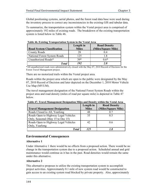
Global positioning systems, aerial photos, and the forest road data base were used during<br />
the inventory process to correct any inconsistencies in the existing GIS and tabular data.<br />
To summarize, the transportation system within the Vestal project area is comprised of<br />
approximately 192 miles of existing roads. The breakdown of the existing transportation<br />
system is listed below in Table 46.<br />
Table 46. Existing Transportation System in the Vestal Area<br />
Length in Road Density<br />
Road System Classification Miles (Miles/Square Mile)<br />
County Roads 28 0.4<br />
National Forest System Roads 125 1.8<br />
Unauthorized Roads* 39* 0.6*<br />
Total 192 2.8<br />
*All unauthorized roads were administratively closed with the May 07, 2010 Record of Decision for the<br />
Forest Travel Management project.<br />
There are no motorized trails within the Vestal project area.<br />
Roads within the project area which are open to the public were designated by the May<br />
07, 2010 Record of Decision and later depicted on the December 1, 2010 Motor Vehicle<br />
Use Map (MVUM).<br />
The travel management designation of the National Forest System Roads within the<br />
project area and road density (miles of road per square mile) is depicted in Table 47<br />
below.<br />
Table 47. Travel Management Designation Miles and Density within the Vestal Area<br />
Length in Road Density<br />
Travel Management Designation<br />
Miles (Miles/Square Mile)<br />
Roads Closed to All, Yearlong 48 0.7<br />
Roads Open to Highway Legal Vehicles<br />
Only, Seasonal (May 15 to Dec 15)<br />
35 0.5<br />
Roads Open to Highway Legal Vehicles<br />
Only, Yearlong<br />
42 0.6<br />
Total 125 1.8<br />
<strong>Environmental</strong> Consequences<br />
Alternative 1<br />
Under Alternative 1 there would be no effects from a proposed action. There would be no<br />
change in the transportation system due to a proposed action. Scheduled annual and grid<br />
maintenance would continue as it has in the past. Road densities would remain the same<br />
under this alternative.<br />
Alternative 2<br />
This alternative proposes to utilize the existing transportation system to accomplish<br />
project activities. Approximately 0.1 mile of new system road would be constructed to<br />
gain access to an existing system road blocked by private property. Also, approximately<br />
144


