

Final Environmental Impact Statement
Final Environmental Impact Statement
Final Environmental Impact Statement

Create successful ePaper yourself
Turn your PDF publications into a flip-book with our unique Google optimized e-Paper software.
VESTAL<br />
PROJECT<br />
United States<br />
Department of Agriculture<br />
Forest Service<br />
FINAL ENVIRONMENTAL IMPACT<br />
STATEMENT<br />
VOLUME I<br />
Hell Canyon Ranger District, Black Hills National Forest<br />
Custer County, South Dakota<br />
April 2012
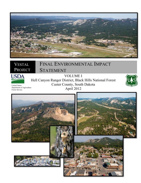
Aerial view of Crazy Horse<br />
Monument taken September<br />
13, 2011. Looking<br />
southwest.<br />
“Custer” sign, Custer, SD<br />
taken September 08, 2010.<br />
Aerial view of the city of Custer, SD<br />
taken September 16, 2011. Looking<br />
northwest.<br />
MPB pitch<br />
tube, with<br />
‘pitched’<br />
beetle.<br />
Aerial view of the Vestal<br />
project area (northwest)<br />
taken September 12, 2011.<br />
Aerial view of the city of<br />
Custer, SD taken September<br />
08, 2010. Looking north.<br />
The U.S. Department of Agriculture (USDA) prohibits discrimination in all its<br />
programs and activities on the basis of race, color, national origin, age, disability,<br />
and where applicable, sex, marital status, familial status, parental status, religion,<br />
sexual orientation, genetic information, political beliefs, reprisal, or because all or<br />
part of an individual’s income is derived from any public assistance program. (Not<br />
all prohibited bases apply to all programs.) Persons with disabilities who require<br />
alternative means for communication of program information (Braille, large-print,<br />
audiotape, etc.) should contact USDA’s TARGET Center at (202)720-2600 (voice<br />
and TDD).<br />
To file a complaint of discrimination, write to USDA, Director, Office of Civil<br />
Rights, 1400 Independence Avenue, S.W., Washington, D.C. 20250-9410, or call<br />
(800)795-3272 (voice) or (202)720-6382 (TDD). USDA is an equal opportunity<br />
provider and employer.
Vestal <strong>Final</strong> <strong>Environmental</strong> <strong>Impact</strong> <strong>Statement</strong><br />
Vestal Project<br />
<strong>Final</strong><br />
<strong>Environmental</strong> <strong>Impact</strong> <strong>Statement</strong><br />
Custer County, South Dakota<br />
Lead Agency: USDA Forest Service<br />
Cooperating Agencies: None<br />
Responsible Official: Lynn Kolund, District Ranger<br />
330 Mount Rushmore Road<br />
Custer, SD 57730<br />
(605) 673-4853<br />
For Information Contact: Kelly Honors, Team Leader<br />
330 Mount Rushmore Road<br />
Custer, SD 57730<br />
(605) 673-4853<br />
Abstract: The Hell Canyon Ranger District of the Black Hills National Forest has prepared a <strong>Final</strong><br />
<strong>Environmental</strong> <strong>Impact</strong> <strong>Statement</strong> (FEIS) in compliance with the National <strong>Environmental</strong> Policy Act<br />
(NEPA), the Healthy Forest Restoration Act (HFRA) and other relevant Federal and State laws and<br />
regulations. The Hell Canyon Ranger District proposes to implement multiple resource management<br />
actions within the Vestal project area on National Forest lands as guided by the Black Hills National<br />
Forest Land and Resource Management Plan as amended. The focus of the proposed action is to<br />
reduce mountain pine beetle risk and fire hazard on National Forest lands surrounding the City of<br />
Custer, SD. Two alternatives are considered in detail. Alternative 1 is the No Action Alternative.<br />
Alternative 2 is the proposed action and includes vegetation treatments designed primarily to reduce<br />
the potential for mountain pine beetle caused mortality within the Vestal project area. Proposed<br />
treatments are also designed to reduce fire hazard. This FEIS discloses the direct, indirect and<br />
cumulative effects resulting from these two alternatives. The preferred alternative is Alternative 2,<br />
with minor modification to proposed treatments on four units.<br />
i
Vestal <strong>Final</strong> <strong>Environmental</strong> <strong>Impact</strong> <strong>Statement</strong><br />
Table of Contents<br />
SUMMARY ........................................................................................................................ i<br />
CHAPTER 1: INTRODUCTION .................................................................................... 1<br />
Document Structure ...................................................................................................... 1<br />
Background .................................................................................................................... 1<br />
Location .......................................................................................................................... 4<br />
Management Direction ................................................................................................. 4<br />
Purpose and Need for Action ..................................................................................... 12<br />
Proposed Action........................................................................................................... 12<br />
Decision Framework ................................................................................................... 13<br />
Public Involvement ...................................................................................................... 13<br />
Issues ............................................................................................................................. 14<br />
CHAPTER 2: COMPARISON OF ALTERNATIVES, INCLUDING THE<br />
PROPOSED ACTION .................................................................................................... 16<br />
Alternatives Considered in Detail .............................................................................. 16<br />
Alternative 1 – No Action ........................................................................................ 16<br />
Alternative 2 – Proposed Action............................................................................. 16<br />
Design Criteria............................................................................................................. 24<br />
Monitoring ................................................................................................................... 24<br />
Alternatives Not Considered in Detail ....................................................................... 25<br />
Comparison of Alternatives........................................................................................ 27<br />
CHAPTER 3: AFFECTED ENVIRONMENT AND ENVIRONMENTAL<br />
CONSEQUENCES ......................................................................................................... 33<br />
Past, Present, and Reasonably Foreseeable Actions ................................................ 33<br />
Forest Vegetation......................................................................................................... 33<br />
Affected Environment ............................................................................................. 33<br />
Cover Types ............................................................................................................... 33<br />
Ponderosa Pine.......................................................................................................... 34<br />
Very Large Sized Trees .............................................................................................. 35<br />
Late Succession.......................................................................................................... 36<br />
Mountain Pine Beetle ................................................................................................ 36<br />
Hardwoods................................................................................................................. 37<br />
Table of Contents
Vestal <strong>Final</strong> <strong>Environmental</strong> <strong>Impact</strong> <strong>Statement</strong><br />
Spruce ........................................................................................................................ 37<br />
Meadows .................................................................................................................... 38<br />
<strong>Environmental</strong> Consequences ................................................................................ 38<br />
Alternative 1- No Action ......................................................................................... 38<br />
Cover Types ............................................................................................................... 38<br />
Ponderosa Pine.......................................................................................................... 38<br />
Very Large Sized Trees .............................................................................................. 41<br />
Late Succession.......................................................................................................... 42<br />
Hardwoods................................................................................................................. 42<br />
Spruce ........................................................................................................................ 42<br />
Meadows .................................................................................................................... 42<br />
Alternative 2 ............................................................................................................. 42<br />
Cover Types ............................................................................................................... 42<br />
Ponderosa Pine.......................................................................................................... 43<br />
Very Large Sized Trees .............................................................................................. 46<br />
Late Succession.......................................................................................................... 47<br />
Hardwoods................................................................................................................. 47<br />
Spruce ........................................................................................................................ 47<br />
Meadows .................................................................................................................... 47<br />
Cumulative Effects .................................................................................................. 48<br />
Ponderosa Pine.......................................................................................................... 48<br />
Late Succession and Very Large Sized Trees ............................................................ 48<br />
Mountain Pine Beetle Risk ........................................................................................ 49<br />
Hardwoods................................................................................................................. 49<br />
Spruce ........................................................................................................................ 50<br />
Meadows .................................................................................................................... 50<br />
Wildlife and Fish ......................................................................................................... 50<br />
Affected Environment ............................................................................................. 50<br />
Snags and Down Woody Material ............................................................................. 50<br />
Management Indicator Species (MIS) ....................................................................... 50<br />
Beaver (MIS) ............................................................................................................. 52<br />
White-tailed Deer (MIS) ............................................................................................ 52<br />
Golden-crowned Kinglet (MIS) ................................................................................. 53<br />
Table of Contents
Vestal <strong>Final</strong> <strong>Environmental</strong> <strong>Impact</strong> <strong>Statement</strong><br />
Black-backed Woodpecker (R2 Sensitive Species and MIS) .................................... 54<br />
Brown Creeper (MIS) ................................................................................................ 54<br />
Ruffed Grouse (MIS) ................................................................................................. 55<br />
Song Sparrow (MIS) .................................................................................................. 56<br />
Mountain Sucker (MIS and R2 Sensitive) ................................................................. 56<br />
Species of Local Concern (SOLC) ............................................................................. 57<br />
Atlantis Fritillary (SOLC) ......................................................................................... 58<br />
Tawny Crescent (SOLC) ........................................................................................... 58<br />
Callused Vertigo (SOLC) .......................................................................................... 59<br />
Mystery Vertigo (SOLC) ........................................................................................... 59<br />
Frigid Ambersnail (SOLC) ........................................................................................ 60<br />
Striate Disc (SOLC)................................................................................................... 60<br />
Sharp-shinned Hawk (SOLC) .................................................................................... 61<br />
Cooper’s Hawk (SOLC) ............................................................................................ 62<br />
Broad-winged Hawk (SOLC) .................................................................................... 62<br />
Northern Saw-whet Owl (SOLC) .............................................................................. 63<br />
Pygmy Nuthatch (SOLC) .......................................................................................... 64<br />
Northern Long-eared Myotis (SOLC) ....................................................................... 65<br />
Small-footed Myotis (SOLC) .................................................................................... 65<br />
Long-eared Myotis (SOLC)....................................................................................... 66<br />
Long-legged Myotis (SOLC)..................................................................................... 67<br />
Northern Flying Squirrel (SOLC) .............................................................................. 67<br />
Meadow Jumping Mouse (SOLC) ............................................................................. 68<br />
Mountain Goat (SOLC) ............................................................................................. 69<br />
Region 2 (R2) Sensitive Species ................................................................................. 70<br />
Bald Eagle (R2 Sensitive Species) ............................................................................ 71<br />
Northern Goshawk (R2 Sensitive Species) ............................................................... 71<br />
Black-backed Woodpecker (R2 Sensitive Species, MIS) ......................................... 71<br />
Northern Leopard Frog (R2 Sensitive Species) ......................................................... 71<br />
Black Hills Redbelly Snake (R2 Sensitive Species) .................................................. 72<br />
Fringed Myotis (R2 Sensitive Species) ..................................................................... 72<br />
Townsend’s Big-eared Bat (R2 Sensitive Species) ................................................... 72<br />
Black-tailed Prairie Dog (R2 Sensitive Species) ....................................................... 73<br />
Table of Contents
Vestal <strong>Final</strong> <strong>Environmental</strong> <strong>Impact</strong> <strong>Statement</strong><br />
Mountain Sucker (R2 Sensitive Species, MIS) ......................................................... 73<br />
Hoary Bat (R2 Sensitive Species) ............................................................................. 74<br />
American Marten (R2 Sensitive Species) .................................................................. 74<br />
Flammulated Owl (R2 Sensitive Species) ................................................................. 74<br />
Cooper’s Mountain Snail (R2 Sensitive Species) ...................................................... 75<br />
Regal Fritillary Butterfly (R2 Sensitive Species) ...................................................... 75<br />
Demand Species ......................................................................................................... 76<br />
Rocky Mountain Elk (Demand Species) ................................................................... 76<br />
Merriam’s Wild Turkey (Demand Species) .......................................................... 77<br />
Migratory Birds ......................................................................................................... 77<br />
Golden Eagle (Migratory Bird) ................................................................................. 77<br />
<strong>Environmental</strong> Consequences ................................................................................ 78<br />
Snags and Down Woody Material ............................................................................. 78<br />
Management Indicator Species (MIS) ....................................................................... 79<br />
Species of Local Concern (SOLC) ............................................................................. 85<br />
Threatened and Endangered Species ........................................................................ 94<br />
Region 2 (R2) Sensitive Species ................................................................................. 95<br />
Summary of Effects on Sensitive Species ................................................................ 95<br />
Demand Species ....................................................................................................... 106<br />
Rocky Mountain Elk (Demand Species) .................................................................. 106<br />
Alternative Effects Summary .................................................................................. 106<br />
Merriam’s Wild Turkey (Demand Species) ............................................................. 107<br />
Alternative Effects Summary .................................................................................. 107<br />
Cumulative Effects .................................................................................................. 107<br />
Migratory Birds ....................................................................................................... 107<br />
Golden Eagle (Migratory Bird) ............................................................................... 107<br />
Fire and Fuels ............................................................................................................ 108<br />
Affected Environment ........................................................................................... 108<br />
Custer Community Wildfire Protection Plan (CWPP) ............................................ 108<br />
Condition Class and Fire Regime ........................................................................... 109<br />
Fire Risk .................................................................................................................. 109<br />
Values at Risk .......................................................................................................... 110<br />
Fire Hazard ............................................................................................................. 111<br />
Table of Contents
Vestal <strong>Final</strong> <strong>Environmental</strong> <strong>Impact</strong> <strong>Statement</strong><br />
Air Quality ............................................................................................................... 113<br />
<strong>Environmental</strong> Consequences .............................................................................. 114<br />
Alternative 1 ........................................................................................................... 114<br />
Direct and Indirect Effects .................................................................................... 115<br />
Air Quality ............................................................................................................... 117<br />
Alternative 2 ........................................................................................................... 117<br />
Direct and Indirect Effects .................................................................................... 117<br />
Air Quality ............................................................................................................... 120<br />
Cumulative Effects ................................................................................................ 121<br />
Air Quality ............................................................................................................... 122<br />
Botany, Rangeland, and Noxious Weeds ................................................................. 122<br />
Affected Environment ........................................................................................... 122<br />
Botany ...................................................................................................................... 122<br />
Species of Local Concern (SOLC) ........................................................................ 123<br />
Region 2 (R2) Sensitive Species ............................................................................ 123<br />
Range ....................................................................................................................... 124<br />
Noxious Weeds ......................................................................................................... 124<br />
<strong>Environmental</strong> Consequences .............................................................................. 124<br />
Alternative 1 ........................................................................................................... 124<br />
Botany ...................................................................................................................... 124<br />
Range ....................................................................................................................... 126<br />
Noxious Weeds ......................................................................................................... 127<br />
Alternative 2............................................................................................................... 127<br />
Botany ...................................................................................................................... 127<br />
Range ....................................................................................................................... 130<br />
Noxious Weeds ......................................................................................................... 131<br />
Cumulative Effects ................................................................................................ 132<br />
Minerals and Geologic Resources ............................................................................ 133<br />
Affected Environment ........................................................................................... 133<br />
<strong>Environmental</strong> Consequences .............................................................................. 133<br />
Direct, Indirect, and Cumulative Effects for All Alternatives .......................... 133<br />
Lands and Special Uses ............................................................................................. 134<br />
Affected Environment ........................................................................................... 134<br />
Table of Contents
Vestal <strong>Final</strong> <strong>Environmental</strong> <strong>Impact</strong> <strong>Statement</strong><br />
<strong>Environmental</strong> Consequences .............................................................................. 134<br />
Alternative 1 ........................................................................................................... 134<br />
Alternative 2 ........................................................................................................... 135<br />
Cumulative Effects ................................................................................................ 135<br />
Heritage Resources .................................................................................................... 135<br />
Affected Environment ........................................................................................... 135<br />
<strong>Environmental</strong> Consequences .............................................................................. 137<br />
Alternative 1 ........................................................................................................... 137<br />
Alternative 2 ........................................................................................................... 137<br />
Cumulative Effects ................................................................................................ 137<br />
Scenery ....................................................................................................................... 138<br />
Affected Environment ........................................................................................... 138<br />
<strong>Environmental</strong> Consequences .............................................................................. 139<br />
Alternative 1 ........................................................................................................... 139<br />
Alternative 2 ........................................................................................................... 139<br />
Cumulative Effects ................................................................................................ 142<br />
Transportation ........................................................................................................... 143<br />
Affected Environment ........................................................................................... 143<br />
<strong>Environmental</strong> Consequences .............................................................................. 144<br />
Alternative 1 ........................................................................................................... 144<br />
Cumulative Effects ................................................................................................ 145<br />
Recreation .................................................................................................................. 146<br />
Affected Environment ........................................................................................... 146<br />
Recreation Opportunity Spectrum (ROS) ................................................................ 146<br />
Developed Recreation .............................................................................................. 146<br />
Dispersed Recreation .............................................................................................. 146<br />
Recreation Special Uses .......................................................................................... 147<br />
Motorized Recreation .............................................................................................. 147<br />
<strong>Environmental</strong> Consequences .............................................................................. 147<br />
Alternative 1 ........................................................................................................... 147<br />
Developed Recreation .............................................................................................. 148<br />
Dispersed Recreation .............................................................................................. 148<br />
Recreation Special Uses .......................................................................................... 148<br />
Table of Contents
Vestal <strong>Final</strong> <strong>Environmental</strong> <strong>Impact</strong> <strong>Statement</strong><br />
Alternative 2 ........................................................................................................... 148<br />
Travel Management ................................................................................................. 149<br />
Mickelson Trail ........................................................................................................ 149<br />
Cumulative Effects ................................................................................................ 149<br />
Soils and Hydrology .................................................................................................. 150<br />
Field Surveys .......................................................................................................... 150<br />
Affected Environment - Soils ................................................................................ 150<br />
Soil Health Assessment ............................................................................................ 151<br />
Soil Erosion ............................................................................................................. 151<br />
Soil Compaction ...................................................................................................... 151<br />
Nutrient Removal ..................................................................................................... 151<br />
<strong>Environmental</strong> Consequences - Soils ................................................................... 151<br />
Soil Erosion – Direct and Indirect Effects............................................................... 151<br />
Alternative 1 ........................................................................................................... 152<br />
Alternative 2 ........................................................................................................... 152<br />
Soil Compaction – Direct and Indirect Effects ........................................................ 152<br />
Alternative 1 ........................................................................................................... 152<br />
Alternative 2 ........................................................................................................... 152<br />
Nutrient Removal – Direct and Indirect Effects ...................................................... 153<br />
Alternative 1 ........................................................................................................... 153<br />
Alternative 2 ........................................................................................................... 153<br />
Soil Heating – Direct and Indirect Effects .............................................................. 153<br />
Alternative 1 ........................................................................................................... 153<br />
Alternative 2 ........................................................................................................... 153<br />
Cumulative Effects - Soils ....................................................................................... 154<br />
Nutrient Removal ..................................................................................................... 154<br />
Soil Heating ............................................................................................................. 154<br />
Soil Erosion ............................................................................................................. 154<br />
Soil Compaction ...................................................................................................... 155<br />
Affected Environment – Hydrology ..................................................................... 155<br />
Watersheds............................................................................................................... 155<br />
Floodplains .............................................................................................................. 157<br />
Wetlands and Riparian ............................................................................................ 157<br />
Table of Contents
Vestal <strong>Final</strong> <strong>Environmental</strong> <strong>Impact</strong> <strong>Statement</strong><br />
Lakes ........................................................................................................................ 157<br />
Streams .................................................................................................................... 157<br />
Beneficial Uses ........................................................................................................ 158<br />
Streamflow Regime .................................................................................................. 159<br />
Stream Health .......................................................................................................... 159<br />
Connected Disturbed Area (CDA) ........................................................................... 160<br />
Water Quality .......................................................................................................... 160<br />
<strong>Environmental</strong> Consequences - Hydrology ......................................................... 160<br />
Aquatic Ecosystems ............................................................................................... 161<br />
Sediment – Direct and Indirect Effects .................................................................... 161<br />
Alternative 1 ........................................................................................................... 161<br />
Alternative 2 ........................................................................................................... 161<br />
Bed and Bank Stability – Direct and Indirect Effects .............................................. 162<br />
Alternative 1 ........................................................................................................... 162<br />
Alternative 2 ........................................................................................................... 162<br />
Stream Flow Regime – Direct and Indirect Effects ................................................. 162<br />
Alternative 1 ........................................................................................................... 162<br />
Alternative 2 ........................................................................................................... 163<br />
Temperature and Oxygen – Direct and Indirect Effects .......................................... 163<br />
Alternative 1 ........................................................................................................... 163<br />
Alternative 2 ........................................................................................................... 163<br />
Water Purity – Direct and Indirect Effects .............................................................. 163<br />
Alternative 1 ........................................................................................................... 163<br />
Alternative 2 ........................................................................................................... 163<br />
Aquatic Life – Direct and Indirect Effects ............................................................... 164<br />
Alternative 1 ........................................................................................................... 164<br />
Alternative 2 ........................................................................................................... 164<br />
Riparian Ecosystems – Direct and Indirect Effects ................................................. 164<br />
Alternative 1 ........................................................................................................... 164<br />
Alternative 2 ........................................................................................................... 164<br />
Wetlands – Direct and Indirect Effects .................................................................... 164<br />
Alternative 1 ........................................................................................................... 164<br />
Alternative 2 ........................................................................................................... 165<br />
Table of Contents
Vestal <strong>Final</strong> <strong>Environmental</strong> <strong>Impact</strong> <strong>Statement</strong><br />
Floodplains – Direct and Indirect Effects ............................................................... 165<br />
Alternative 1 ........................................................................................................... 165<br />
Alternative 2 ........................................................................................................... 165<br />
Watershed Condition Class – Direct and Indirect Effects ...................................... 165<br />
Alternative 1 ........................................................................................................... 165<br />
Alternative 2 ........................................................................................................... 165<br />
Cumulative Effects - Hydrology ........................................................................... 165<br />
Sediment................................................................................................................... 166<br />
Bed and Bank Stability ............................................................................................ 166<br />
Stream Flow Regimes .............................................................................................. 166<br />
Temperature and Oxygen ........................................................................................ 166<br />
Water Purity ............................................................................................................ 167<br />
Aquatic Life.............................................................................................................. 167<br />
Riparian Ecosystems................................................................................................ 167<br />
Wetlands .................................................................................................................. 167<br />
Floodplains .............................................................................................................. 167<br />
Watershed Condition Class ..................................................................................... 167<br />
Best Management Practices (BMP) Effectiveness .............................................. 167<br />
Socio-Economics ........................................................................................................ 168<br />
Short Term Uses and Long Term Productivity ...................................................... 172<br />
Unavoidable Adverse Effects ................................................................................... 172<br />
Irreversible and Irretrievable Commitments of Resources .................................. 172<br />
<strong>Environmental</strong> Justice .............................................................................................. 173<br />
Other Required Disclosures ..................................................................................... 173<br />
CHAPTER 4: CONSULTATION AND COORDINATION .................................... 174<br />
CHAPTER 5: LITERATURE CITED and GLOSSARY ......................................... 181<br />
Literature Cited ......................................................................................................... 181<br />
Glossary ...................................................................................................................... 194<br />
Index ........................................................................................................................... 210<br />
Table of Contents
Vestal <strong>Final</strong> <strong>Environmental</strong> <strong>Impact</strong> <strong>Statement</strong><br />
List of Figures<br />
Figure 1. At-Risk Communities (ARC) with 3-Mile WUI Boundary .............................. 11<br />
Figure 2. Ponderosa Pine Structural Stages-Existing Condition. ..................................... 29<br />
Figure 3. Ponderosa Pine Structural Stages - Alt. 1-No Action. ...................................... 29<br />
Figure 4. Ponderosa Pine Structural Stages - Alt. 2-Proposed Action. ............................ 29<br />
Figure 5. MPB Risk Rating (in acres)-Existing Condition. .............................................. 30<br />
Figure 6. MPB Risk Rating (in acres)-Alternative 2. ....................................................... 30<br />
Figure 7. Fire Hazard Rating Summary for Vestal Project Area. ..................................... 31<br />
Figure 8. Fire History in and around the Project Area and the Point Fire History within<br />
the Project Boundary....................................................................................................... 110<br />
Figure 9. At-Risk Communities (ARC) with 3 Mile WUI, and Structures Located within<br />
the Project Area............................................................................................................... 111<br />
Figure 10. Existing Condition Fire Hazard Rating. ........................................................ 113<br />
Figure 11. Alternative 1 Fire Hazard Rating (Year 2018). ............................................. 116<br />
Figure 12. Alternative 2 Fire Hazard Rating (Year 2018). ............................................. 118<br />
Figure 13. Fire Hazard Rating by Alternative. ............................................................... 119<br />
List of Tables<br />
Table 1. Vestal Project Area Legal Description ................................................................. 4<br />
Table 2. Management Area Direction in the Vestal Project Area-on National Forest<br />
System Lands Only (60% of total lands within the project boundary) ............................... 5<br />
Table 3. Comparison of Cover Types ............................................................................... 28<br />
Table 4. Comparison of Ponderosa Pine Structural Stages............................................... 28<br />
Table 5. MPB Risk Rating by Alternative ........................................................................ 30<br />
Table 6. Fire Hazard Rating Acres by Alternative at Year 2018-For Entire Project Area 31<br />
Table 7. Alternative 2 Proposed Mechanical Vegetation Treatments .............................. 32<br />
Table 8. Alternative 2 Proposed Fuel Reduction Treatments ........................................... 32<br />
Table 9. Total Miles of Forest Service Roads on National Forest Land within the Project<br />
Area, by Alternative .......................................................................................................... 32<br />
Table 10. Designation of National Forest System Roads within the Project Area ........... 32<br />
Table 11. Existing Cover Types in the Vestal Project Area ............................................. 33<br />
Table 12. Existing Ponderosa Pine Structural Stages (SS) in the Vestal Project Area ..... 34<br />
Table of Contents
Vestal <strong>Final</strong> <strong>Environmental</strong> <strong>Impact</strong> <strong>Statement</strong><br />
Table 13. Structural Stage (SS) Objective Percentages for Ponderosa Pine in MAs 4.1,<br />
5.1, and 5.4 across the Black Hills National Forest .......................................................... 34<br />
Table 14. Existing Pine Structural Stage Acres and Percentages in MA 4.1.................... 35<br />
Table 15. Existing Pine Structural Stage Acres and Percentages in MA 5.1.................... 35<br />
Table 16. Existing Pine Structural Stage Acres and Percentages in MA 5.4.................... 35<br />
Table 17. Existing Percentages of Very Large Sized Pine Acres by Management Area . 36<br />
Table 18. MPB Risk Rating by Pine Structural Stage ...................................................... 37<br />
Table 19. Current MPB Risk Rating for Ponderosa Pine in Vestal .................................. 37<br />
Table 20. Alternative 1 Pine Structural Stages in the Vestal Project Area, Projected to<br />
Year 2018 and Compared to Existing Condition .............................................................. 38<br />
Table 21. Alternative 1 Pine SS in MA 4.1, Forest-Wide ................................................ 40<br />
Table 22. Alternative 1 Pine SS in MA 5.1, Forest-Wide ................................................ 40<br />
Table 23. Alternative 1 Pine SS in MA 5.4, Forest-Wide ................................................ 41<br />
Table 24. Alternative 1 Acres of SS4 with an Average Tree Size of Very Large at Year<br />
2018................................................................................................................................... 41<br />
Table 25. Alternative 1 Percentage of SS4 with an Average Tree Size of Very Large at<br />
Year 2018 .......................................................................................................................... 41<br />
Table 26. Pine Structural Stages by Alternative within the Vestal Project Area .............. 43<br />
Table 27. MPB Risk Rating - Alternative 2 Compared to Existing Condition................. 44<br />
Table 28. Forest-Wide Management Area 4.1 Pine Structural Stages by Alternative ..... 45<br />
Table 29. Forest-Wide Management Area 5.1 Pine Structural Stages by Alternative ..... 45<br />
Table 30. Forest-Wide Management Area 5.4 Pine Structural Stages by Alternative ..... 46<br />
Table 31. All Alternatives: Acres of SS4 with an Average Tree Size of Very Large at<br />
Year 2018 .......................................................................................................................... 46<br />
Table 32. All Alternatives Percentage of SS4 with an Average Tree Size of Very Large at<br />
Year 2018 .......................................................................................................................... 47<br />
Table 33. MIS List and Rationale for Inclusion in Project-Level Analysis ...................... 51<br />
Table 34. Current Screening Cover in the Vestal Project Area on Forest Service Land .. 53<br />
Table 35. SOLC List and Rationale for Project-Level Analysis ...................................... 57<br />
Table 36. Summary of Effects on MIS ............................................................................. 79<br />
Table 37. Summary of Effects to SOLC ........................................................................... 85<br />
Table 38. Summary of Effects on R2 Sensitive Species ................................................... 95<br />
Table 39. Fire History Occurrence and the Size of the Fires from 1950 to Present ....... 109<br />
Table 40. Existing Fire Hazard within Whole Project Area and within 3 Mile WUI. .... 112<br />
Table of Contents
Vestal <strong>Final</strong> <strong>Environmental</strong> <strong>Impact</strong> <strong>Statement</strong><br />
Table 41. Fire Hazard Rating for Existing Condition and No Action at Year 2018....... 116<br />
Table 42. Fire Hazard Rating within WUI - No Action at Year 2018 ............................ 116<br />
Table 43. Fire Hazard Rating by Alternative in Whole Project Area at Year 2018 ....... 119<br />
Table 44. Fire Hazard Rating by Alternative in WUI at Year 2018 ............................... 119<br />
Table 45. Known State Listed and Species of Insufficient Information ......................... 123<br />
Table 46. Existing Transportation System in the Vestal Area ........................................ 144<br />
Table 47. Travel Management Designation Miles and Density within the Vestal Area 144<br />
Table 48. Road Mileage and Density by Alternative ...................................................... 145<br />
Table 49. Soils in the Vestal Project Area (USDA NRCS 2011) ................................... 150<br />
Table 50. HUC 12 Watershed within the Vestal Project Area ....................................... 156<br />
Table 51. Stream Mileages within the Vestal Project Area ............................................ 158<br />
Table 52. Vestal Stream with Additional Beneficial Uses ............................................. 158<br />
Table 53. Watersheds analyzed for Cumulative Effects ................................................. 166<br />
Table 54. Area Population Based on 2000 and 2010 Census ......................................... 169<br />
Table 55. Percent Population by Ethnicity Based on the 2010 Census .......................... 169<br />
Table 56. Economic Well-Being Based on 2006-2010 Census ...................................... 170<br />
Table of Contents
Commonly Used Acronyms and Abbreviations<br />
APE Area of Potential Effect<br />
ARC At-Risk-Community<br />
BA Basal Area<br />
BABE,<br />
BA/BE<br />
Biological<br />
Assessment/Biological<br />
Evaluation<br />
BCC Birds of Conservation<br />
Concern<br />
BCR Bird Conservation Region<br />
BHNF Black Hills National Forest<br />
BHNF<br />
LRMP<br />
Black Hills National Forest<br />
Revised Land and Resource<br />
Management Plan<br />
BMP Best Management Practices<br />
CCF Hundred Cubic Feet<br />
CDA Connected Disturbed Areas<br />
CEQ Council on <strong>Environmental</strong><br />
Quality<br />
CFR Code of Federal Regulations<br />
CWD Coarse Woody Debris<br />
CWPP Community Wildfire<br />
Protection Plan<br />
dbh Diameter at Breast Height<br />
DENR Department of Environment<br />
and Natural Resources<br />
EIS <strong>Environmental</strong> <strong>Impact</strong><br />
<strong>Statement</strong><br />
EPA <strong>Environmental</strong> Protection<br />
Agency<br />
FEMA Federal Emergency<br />
Management Agency<br />
FPS&G Forest Plan Standards and<br />
Guidelines<br />
FRCC Fire Regime Condition<br />
Class<br />
FSM Forest Service Manual<br />
FSR Forest Service Road<br />
FY Fiscal Year<br />
GIS Geographic Information<br />
Systems<br />
HFRA Health Forest Restoration<br />
Act<br />
HUC Hydrologic Unit Code<br />
IDT, ID Interdisciplinary Team<br />
Team<br />
LRMP Land and Resource<br />
Management Plan<br />
MA Management Area<br />
MBBH Monitoring Birds of the<br />
Black Hills<br />
MIS Management Indicator<br />
Species<br />
MPB Mountain Pine Beetle<br />
MVUM Motor Vehicle Use Map<br />
NEPA National <strong>Environmental</strong><br />
Policy Act<br />
NFMA National Forest<br />
Management Act<br />
NFS National Forest System<br />
NFSR National Forest System<br />
Road<br />
NHPA National Historic<br />
Preservation Act<br />
NRHP National Register of<br />
Historic Places
OHV Off Highway Vehicle<br />
POL Products Other than Logs<br />
R2 Forest Service Region 2<br />
(Rocky Mountain Region)<br />
RIS Resource Information<br />
System<br />
RMBO Rocky Mountain Bird<br />
Observatory<br />
RMRS Rocky Mountain Research<br />
Station<br />
ROS Recreation Opportunity<br />
Spectrum<br />
ROW Right-of-way<br />
RX Prescribed Fire<br />
SD South Dakota<br />
SDDENR South Dakota Department<br />
of Environment and Natural<br />
Resources<br />
SDGFP South Dakota Game Fish<br />
and Parks<br />
SDNHP South Dakota Natural<br />
Heritage Program<br />
SHPO State Historic Preservation<br />
Office<br />
SHR Stream Health Rating<br />
SIO Site Integrity Objective<br />
SOLC Species of Local Concern<br />
SOPA Schedule of Proposed<br />
Action<br />
SS Structural Stage<br />
SUP Special Use Permits<br />
TES Threatened, Endangered, &<br />
Sensitive Species<br />
THPO Tribal Historic Preservation<br />
Office<br />
USC United States Code<br />
USDA United States Department of<br />
Agriculture<br />
USFS United States Department of<br />
Agriculture Forest Service<br />
USFWS United States Fish and<br />
Wildlife Service<br />
USGS United States Geological<br />
Survey<br />
WCP Watershed Conservation<br />
Practice<br />
WIZ Water Influence Zone<br />
WUI Wildland Urban Interface
Vestal <strong>Final</strong> <strong>Environmental</strong> <strong>Impact</strong> <strong>Statement</strong> Summary<br />
SUMMARY<br />
The Hell Canyon Ranger District of the Black Hills National Forest proposes to<br />
implement multiple resource management actions within the Vestal project area as<br />
guided by the Black Hills National Forest Land and Resource Management Plan and<br />
Phase II Amendment (Forest Plan). Due to the existing epidemic of mountain pine<br />
beetles (MPB) in the project area (see Appendix H), the Vestal project was developed<br />
under the authorities of the Healthy Forest Restoration Act (HFRA). The proposed action<br />
includes commercial and non-commercial vegetation treatments and prescribed burning<br />
to reduce mountain pine beetle risk and fire hazard on National Forest lands surrounding<br />
the City of Custer, SD. Proposed resource management actions apply only to National<br />
Forest lands.<br />
The Vestal project area surrounds the city of Custer, South Dakota within Custer County<br />
(see Map 1 in Appendix A). The project area includes approximately 43,516 acres;<br />
25,823 (60%) of which are National Forest System lands and 17,693 (40%) which are<br />
private lands (including City or County properties). Given the project location around the<br />
City of Custer, there are extensive private dwellings, businesses, and government offices<br />
in this project area. The Hell Canyon Ranger District office and shop, as well as the<br />
Black Hills National Forest Supervisor’s Office, are also located within the project area.<br />
High use developed recreation sites occur on private, State and Federal lands within or<br />
adjacent to the project area. Sites within the project boundary include; approximately<br />
eight miles of the Mickelson trail, Bismarck Lake campground, Crazy Horse Mountain,<br />
and numerous private campgrounds. Other recreation areas adjacent to the project area<br />
include Custer State Park.<br />
All state and county roads which access the City of Custer are within the project area for<br />
at least a portion of their length. Therefore, all visitors to Custer will travel through the<br />
project area.<br />
The focus of the proposed action is to treat vegetation on a broad landscape scale to<br />
reduce the threat to ecosystem components from the existing MPB epidemic. The<br />
proposed action would also reduce fire hazard and consequently, the potential for highintensity,<br />
large-scale wildfire. Implications of continued spread of this MPB epidemic<br />
include increased tree mortality across the landscape, on both National Forest and private<br />
lands. Consequently, the further accumulation of hazardous fuels would increase the<br />
potential for severe large-scale wildfires threatening forest resources and other values<br />
within the area including major changes in scenery and alteration of wildlife habitat.<br />
Schmid et al. 2007, states “the most important aspect of managing mature ponderosa pine<br />
stands on the Black Hills National Forest is minimizing MPB-caused mortality.”<br />
This action is needed because the Vestal project area is within an expanding mountain<br />
pine beetle epidemic. The Black Hills National Forest, Forest Supervisor, Craig Bobzien,<br />
has determined that a MPB epidemic is occurring in the project area (Appendix H). Over<br />
the past 3-4 years there has been a rapidly growing amount of MPB caused mortality in<br />
the southern Black Hills around the City of Custer. All measures of MPB activity<br />
indicate a rapidly growing MPB epidemic with a substantial increase in tree mortality<br />
over the past 3 years. Approximately 61% of ponderosa pine stands on National Forest<br />
lands in the project area are at high risk for MPB caused mortality.<br />
i
Vestal <strong>Final</strong> <strong>Environmental</strong> <strong>Impact</strong> <strong>Statement</strong> Summary<br />
At this time, there are larger pockets of MPB activity in the northern and western parts of<br />
the project area. The southern parts of the project are less impacted at this time, but<br />
beetle activity is occurring there at a rapidly growing rate on both National Forest and<br />
private lands. Approximately 17,693 acres (40%) of the project area is private land with<br />
over 7,000 of those acres being forested. Private landowners are experiencing MPB<br />
caused mortality on their property and many are taking actions such as thinning,<br />
sanitation, cut and chunk, and individual tree spraying. Many private landowners are<br />
worried about the potential spread of MPB from National Forest lands to their own. This<br />
project would reduce MPB risk on National forest lands and would reduce the potential<br />
for MPB spread onto private lands.<br />
The Hell Canyon Ranger District held a public meeting to discuss the Vestal project on<br />
Wednesday, May 11, 2011 at the Custer High School, Custer, SD. The proposed action<br />
was described in a scoping document (April 20, 2011) and mailed to approximately 149<br />
individuals, tribal representatives, groups, government entities and other interested<br />
members of the public. The proposed action includes vegetation treatments, prescribed<br />
fire, and fuel treatments on National Forest lands only.<br />
The Forest Service evaluated the following alternatives:<br />
ii<br />
Alternative 1 – No Action: The National <strong>Environmental</strong> Policy Act<br />
(NEPA) requires the study of the ‘No Action’ alternative as a basis<br />
for comparing effects of the proposed action and other alternatives.<br />
The ‘No Action’ alternative assumes no implementation of any<br />
elements of the proposed action or other action alternatives would<br />
take place within the Vestal project area. This alternative represents<br />
no attempt to actively respond to the purpose and need for action or<br />
the issues identified during scoping. For example, there would be no<br />
effort to modify existing vegetation or related fuels conditions in the<br />
project area; current timber sales, fire suppression efforts, noxious<br />
weeds treatments and regular system road maintenance would<br />
continue on National Forest lands.<br />
Alternative 2 – Proposed Action: The proposed action is designed to<br />
address the purpose of and need for action. Strategies proposed to<br />
reduce mountain pine beetle caused mortality include, mechanical<br />
thinning to reduce density, and sanitation which removes green trees<br />
that have live beetle brood in them. This alternative would be most<br />
effective if implemented immediately. In the Black Hills, stands that<br />
are less than 80 ft 2 /acre basal area are at a reduced risk. Therefore,<br />
reducing stand basal area is a preventative treatment. Sanitation is<br />
considered a suppression strategy because it directly removes beetle<br />
larvae from the forest, directly reducing beetle populations. A total of<br />
up to 25,449 acres, which includes pine encroachment, hardwood<br />
release, hardwood conversion, and sanitation, of the project area<br />
would receive vegetation treatments under this alternative. Fuel<br />
treatments, including thinning, deadfall (mechanical treatment of<br />
down logs and branches), and prescribed burning, would occur on up<br />
to 25,634 acres. The proposed action includes the following
Vestal <strong>Final</strong> <strong>Environmental</strong> <strong>Impact</strong> <strong>Statement</strong> Summary<br />
modifications to the transportation system in the project area: 0.6<br />
miles of unauthorized road is needed for access and would be<br />
converted to a system road then closed following use; and 0.9 miles of<br />
system road would be closed to protect resources either with physical<br />
closures or gates. Refer to Appendix A for proposed action maps for<br />
both vegetation treatments and fuels treatments, as well as the<br />
transportation map noting proposed adjustments to the transportation<br />
system.<br />
The deciding official will review the environmental analysis, all supporting documents<br />
and public input in order to make the following decisions:<br />
(1) Whether or not active management is appropriate in the Vestal project area at this<br />
time and if so, what actions should occur.<br />
(2) Whether the information in this analysis is sufficient to make a reasoned decision.<br />
iii
Vestal <strong>Final</strong> <strong>Environmental</strong> <strong>Impact</strong> <strong>Statement</strong> Chapter 1<br />
CHAPTER 1: INTRODUCTION<br />
Document Structure<br />
The Forest Service has prepared this <strong>Final</strong> <strong>Environmental</strong> <strong>Impact</strong> <strong>Statement</strong> (FEIS) in<br />
compliance with the National <strong>Environmental</strong> Policy Act (NEPA), the Healthy Forest<br />
restoration Act (HFRA) and other relevant Federal and State laws and regulations. This<br />
Draft <strong>Environmental</strong> <strong>Impact</strong> <strong>Statement</strong> discloses the direct, indirect, and cumulative<br />
environmental impacts that would result from the proposed action and no action<br />
alternatives. All numbers and figures are approximate measures based on known project<br />
conditions. The document is organized into five chapters:<br />
• Chapter 1: Introduction: The section includes information on the history of the<br />
project proposal, the purpose of and need for the project, and the agency’s proposal<br />
for achieving that purpose and need. This section also details how the Forest Service<br />
informed the public of the proposal and how the public responded.<br />
• Chapter 2: Alternatives, including the Proposed Action: This section provides a<br />
more detailed description of the agency’s proposed action. A summary comparison<br />
of the proposed action and no action alternatives is also provided in this chapter.<br />
• Chapter 3: Affected Environment and <strong>Environmental</strong> Consequences: This section<br />
describes the environmental effects of implementing the proposed action and no<br />
action alternatives. This analysis is organized by resource area (i.e. Silviculture,<br />
Wildlife, Recreation). The effects of the No Action alternative provide a baseline for<br />
evaluating and comparing to the proposed action alternative.<br />
• Chapter 4: Consultation and Coordination: This section provides a list of preparers,<br />
and also a list of agencies, groups and persons consulted during the development of<br />
the Vestal <strong>Final</strong> <strong>Environmental</strong> <strong>Impact</strong> <strong>Statement</strong> (FEIS).<br />
• Chapter 5: Literature Cited and Glossary<br />
• Index<br />
• Appendices: The appendices provide more detailed information to support the<br />
analyses presented in the environmental assessment.<br />
Additional documentation, including more detailed analyses of project-area resources,<br />
may be found in the project planning record located at the Hell Canyon Ranger District<br />
Office in Custer, South Dakota.<br />
Background<br />
The Vestal project area surrounds the city of Custer, South Dakota, encompassing a large<br />
amount (40%) of private land. The private, or non-Forest Service, lands are concentrated<br />
within the city limits, but occur as scattered parcels throughout the whole project area<br />
(see maps in Appendix A). There are extensive private dwellings, businesses, and<br />
government offices within the project area. These structures also occur throughout the<br />
project area (see Maps 6 and 7 in Appendix A). There are many high-use developed<br />
1
Vestal <strong>Final</strong> <strong>Environmental</strong> <strong>Impact</strong> <strong>Statement</strong> Chapter 1<br />
recreational sites that occur on private, state, and federal lands within or adjacent to the<br />
project area. All visitors to the City of Custer will travel through the project area.<br />
The Black Hills National Forest, Forest Supervisor, Craig Bobzien, has determined that a<br />
MPB epidemic is occurring in the project area (Appendix H). Over the past 3-4 years<br />
there has been a rapidly growing amount of beetle caused mortality in the southern Black<br />
Hills around the City of Custer, on both National Forest and private lands. All measures<br />
of MPB activity indicate a rapidly growing MPB epidemic with a substantial increase in<br />
tree mortality over the past 3 years. Approximately 61% of ponderosa pine stands, on<br />
National Forest lands in the project area are at high risk for MPB caused mortality.<br />
2<br />
February 2009-Hwy16/385, mountain top in photo is approximately one mile in<br />
distance. MPB killed trees appear red/brown along the horizon.<br />
September 2011-Hwy16/385, from approximately same location as photo above. MPB<br />
killed trees appear red/brown along the horizon.
Vestal <strong>Final</strong> <strong>Environmental</strong> <strong>Impact</strong> <strong>Statement</strong> Chapter 1<br />
At this time, there are larger pockets of beetle activity in the northern and western parts<br />
of the project area. The southern parts of the project are less impacted at this time, but<br />
beetle activity is occurring there at a rapidly growing rate. The primary management tool<br />
for reducing MPB-caused mortality is to remove the infested trees and to reduce the<br />
overall density of the remaining trees through mechanical thinning.<br />
Private land is also being impacted by the MPB epidemic. Approximately 7,000 acres of<br />
private forested land occurs within the Vestal project area. Many land owners are taking<br />
steps to protect their properties by thinning stands, removing trees infested with beetles<br />
(sanitation), cutting and chunking of infested trees, and spraying individual trees to<br />
protect them against the MPB epidemic. Land owners have voiced their concern about<br />
adjacent National Forest lands infested with MPB and the continuing spread onto their<br />
own land. Mountain pine beetles are moving across all ownerships within this project<br />
area.<br />
Fire hazard is currently high to very high on approximately 84% of National Forest lands<br />
in the project area. This signifies substantial potential for large-scale, high-intensity<br />
wildfires to occur. Such fires could threaten lives and property, as well as, resource<br />
values.<br />
Custer County prepared a Community Wildfire Protection Plan (CWPP) which was<br />
approved by resolution in 2011 (resolution 2011-7). The CWPP identified the City of<br />
Custer at-risk community (ARC) as an urban interface environment with a high density of<br />
structures and infrastructure. In many areas the structures lack defensible fire protection<br />
space. There is a community watershed for municipal water source at high risk of fire<br />
impacts. Also there is a high potential for economic loss, and likelihood for loss of<br />
housing and businesses in the event of a wildfire. The Custer County CWPP identifies a<br />
3 mile radius from the city limits of the City of Custer as a Community at Risk boundary.<br />
This 3 mile ARC radius of the city limits is the Wildland Urban Interface (WUI).<br />
Healthy Forest Restoration Act (HFRA)<br />
The Healthy Forest Restoration Act (HFRA) was signed by President Bush in 2003 (H.R.<br />
1904) for the purpose of expediting hazardous fuels reduction and forest restoration<br />
projects on Federal lands at risk of wildland fire or insect and disease epidemics.<br />
The HFRA is comprised of a variety of provisions to expedite hazardous fuels reductions<br />
on specific types of National Forest land. The Vestal Project is an authorized hazardous<br />
fuels reduction project under Section 102(a)(4). The project area meets the qualifications<br />
because of the existing MPB epidemic occurring within and adjacent to the project area,<br />
which poses a significant threat to resource values on National Forest and private lands<br />
(see Appendix H). The Vestal project will be analyzed under the provisions of the<br />
HFRA, Section 102(a)(4).<br />
The HFRA provided expedited procedures for complying with National <strong>Environmental</strong><br />
Policy Act (NEPA) requirements. Section 104 of HFRA provides guidance on the range<br />
of alternatives studied and disclosed in the NEPA document. All authorized hazardous<br />
fuel reduction projects must be consistent with Forest Plan direction.<br />
3
Vestal <strong>Final</strong> <strong>Environmental</strong> <strong>Impact</strong> <strong>Statement</strong> Chapter 1<br />
Location<br />
The Vestal project area is located surrounding the city of Custer, South Dakota within<br />
Custer County (see Map 1, Appendix A). The project area includes approximately 43,516<br />
acres; 25,823 (60%) of which are National Forest System lands and 17,693 (40%) which<br />
are private lands (including City or County properties). Given the project location around<br />
the City of Custer, there are extensive private dwellings, businesses, and government<br />
offices in this project area. The Hell Canyon Ranger District office and shop, as well as<br />
the Black Hills National Forest Supervisor’s Office, are also located within the project<br />
area.<br />
All state and county roads which access the City of Custer are within the project area for<br />
at least a portion of their length. Therefore, all visitors to Custer will travel through the<br />
project area.<br />
The project area includes all or portions of lands with the following legal descriptions,<br />
Black Hills Meridian.<br />
4<br />
Table 1. Vestal Project Area Legal Description<br />
Township Range Section<br />
2S 3E 36<br />
2S 4E 25-36<br />
3S 3E 1,12,13,24,25,36<br />
3S 4E All<br />
3S 5E 7-10, 15-22, 27-34<br />
4S 4E 1-3, 12, 13, 24<br />
4S 5E 3-8, 17, 18<br />
Management Direction<br />
The Revised Land and Resource Management Plan (Forest Plan), as amended (2006),<br />
provides direction for the management of the forest. The Forest Plan contains<br />
management goals and objectives, management area direction, and identifies desired<br />
future conditions for the forest. Resource specialists reviewed the current condition of the<br />
project area and compared these conditions with the desired conditions identified in the<br />
Forest Plan including applicable goals and objectives. Opportunities for improvement<br />
were identified.<br />
Management Areas<br />
The Forest Plan assigns a management emphasis to each portion of the Forest to meet<br />
multiple-use objectives. For each designated management area (MA), Chapter 3 of the<br />
Forest Plan includes a description of desired future conditions, goals, objectives,<br />
standards, and guidelines. Specific direction is provided for management of mountain<br />
pine beetle outbreaks and fuels. There are four management areas within the Vestal<br />
project area (Map 2, Appendix A). Table 2 displays the management area designations<br />
and acreage within the Vestal project area.
Vestal <strong>Final</strong> <strong>Environmental</strong> <strong>Impact</strong> <strong>Statement</strong> Chapter 1<br />
Table 2. Management Area Direction in the Vestal Project Area-on National Forest System<br />
Lands Only (60% of total lands within the project boundary)<br />
Percent<br />
Acres in (%) of<br />
Management Project Project<br />
Management Emphasis and<br />
Area Area Area<br />
Management Theme<br />
Big Game Winter Range: These areas are managed<br />
5.4 10,723 42%<br />
to provide high-quality winter and transitional habitat<br />
for deer and elk, high-quality turkey habitat, habitat for<br />
other species, and a variety of multiple uses.<br />
Resource Production: These areas are managed for<br />
wood products, water yield, and forage production,<br />
5.1 10,325 40% while providing other commercial products, visual<br />
quality, diversity of wildlife and a variety of other<br />
goods and services.<br />
Limited Motorized Use and Forest Products<br />
(Buckhorn Mountain): These areas are managed for<br />
non-motorized recreation, while providing for timber<br />
4.1 4,472 17% production, forage production, visual quality and a<br />
diversity of wildlife. Roads provide intermittent<br />
commercial access, but are normally closed to other<br />
than administrative use.<br />
Developed Recreation Complex (Bismarck Lake):<br />
8.2 303 1%<br />
These areas are managed for recreational opportunities<br />
and visual qualities adjacent to developed recreation<br />
sites and bodies of water.<br />
Forest Plan Goals and Objectives<br />
The Forest Plan establishes eleven multiple use goals and associated objectives for<br />
management of the Forest. The goals and objectives, applicable to specific resource<br />
management issues needing resolution, provide the basic direction for defining the<br />
purpose and need and subsequently developing the project proposal. The eleven Forest<br />
Plan goals are discussed in Chapter I of the Forest Plan. The Responsible Official for the<br />
Vestal Project has chosen to propose resource management actions that respond to Forest<br />
Plan Goals 2, 4, and 10.<br />
Goal 2: Provide for a variety of life through management of biologically diverse<br />
ecosystems.<br />
Objective 201: Manage for a minimum of 92,000 acres of aspen, and<br />
16,000 acres of bur oak during the life of the Plan. The highest priority<br />
for hardwood restoration is where conifers (e.g., spruce and pine) have<br />
out-competed aspen adjacent to riparian systems that once supported<br />
beaver.<br />
• Opportunity exists to increase/maintain hardwood communities by<br />
reducing pine competition within these stands. In addition,<br />
opportunities exist to enhance and expand hardwood inclusions by<br />
opening stand canopies and removing conifers.<br />
5
Vestal <strong>Final</strong> <strong>Environmental</strong> <strong>Impact</strong> <strong>Statement</strong> Chapter 1<br />
6<br />
Objective 205: Manage for 122,000 acres of prairie grassland and 3,600<br />
acres of meadow during the life of the Plan.<br />
• Opportunity exists to maintain existing meadows within the project<br />
area. Most of these meadows are currently experiencing<br />
encroachment by pine. Meadows act as natural fuelbreaks.<br />
Goal 4: Provide for scenic quality, a range of recreational opportunities, and protection<br />
of heritage resources in response to the needs of the Black Hills National Forest visitors<br />
and local communities.<br />
Objective 402: Provide natural appearing landscapes with diverse scenery<br />
and enhance opportunities to enjoy attractive settings...<br />
• Opportunity exists to enhance/maintain landscapes in and around<br />
existing recreation sites and throughout the project area, by<br />
removing MPB infested trees and thinning stands to reduce insect<br />
damage and wildfire hazard. In addition, removal of MPB infested<br />
trees would enhance public safety in these areas.<br />
Goal 10: Establish and maintain a mosaic of vegetation conditions to reduce occurrences<br />
of catastrophic fire, insect, and disease events, and facilitate insect and disease<br />
management and firefighting capability.<br />
Objective 10-01: Manage for 50 to 75 percent moderate-to-low fire<br />
hazard in the wildland-urban interface and reduce fire hazard within<br />
proximity of structures to current NFPA standards…<br />
• Opportunity exists to reduce existing fire hazard within WUI that<br />
currently exceeds objectives on National Forest System lands<br />
within the project area.<br />
Objective 10-04: Reduce or otherwise treat fuels commensurate with risks<br />
(fire occurrence), hazard (fuel flammability), and land and resource values<br />
common to the area, using the criteria in Forest-wide Guideline 4110.<br />
• Opportunity exists to treat fuels and reduce hazards within the<br />
project area.<br />
Objective 10-05: Manage wildfires using the appropriate response based<br />
on management area emphasis, existing values, risk of ignition, and fuel<br />
hazards within a given area.<br />
• Opportunity exists to reduce existing and activity fuels to a<br />
manageable level, facilitating a proactive and effective response to<br />
wildfire.<br />
Objective 10-06: Develop fuel management and protection strategies for<br />
intermixed land ownerships in partnership with private, state, and other<br />
federal agencies.<br />
• Opportunity exists to coordinate with the State and County based<br />
on goals established in the Custer County Community Wildfire<br />
Protection Plan (CWPP) to reduce fuels on both public and private
Vestal <strong>Final</strong> <strong>Environmental</strong> <strong>Impact</strong> <strong>Statement</strong> Chapter 1<br />
lands in order to reduce the potential for large wildfires that could<br />
affect homes, infrastructure, and other ecosystem values.<br />
Objective 10-07: Where outbreaks of mountain pine beetle could present<br />
risks to management objectives for ponderosa pine, reduce acreage of<br />
ponderosa pine stands that are in medium or high risk for infestation.<br />
• Opportunity exists to reduce the acreage of pine stands at high risk<br />
of MPB infestations by removing infested trees and reducing the<br />
overall stand density.<br />
Forest-wide standards and guidelines related to insects and disease:<br />
Guideline 4201a: Plan management activities with consideration for<br />
potential insect or disease outbreaks. Use integrated pest management<br />
strategies where insect or disease outbreaks may adversely affect<br />
management objectives. Utilize preventive vegetation management<br />
practices, including silvicultural treatments, to protect forest stands from<br />
insect and disease epidemics.<br />
Standard 4201b: During scheduled management activities, minimize<br />
susceptibility to mountain-pine-beetle epidemics by reducing average<br />
basal area to 70 or less in pine stands, except where denser stands are<br />
needed to meet other management objectives.<br />
Standard 4201c: Use the following insect-and-disease protection measures:<br />
Manage vegetation in and adjacent to high-use recreation areas to improve forest<br />
conditions, as needed to maintain or improve the desired recreation settings(s) or<br />
to conserve R2 sensitive or species of local concern and snails. In and adjacent to<br />
developed recreation sites actively treat insect and diseases to reduce pest<br />
populations.<br />
Standard 4201d: Consider spatial array of stand conditions when planning<br />
harvests to reduce their potential for mountain pine beetle epidemics. For<br />
example, silvicultural treatments may be appropriate within or adjacent to dense<br />
mature stands.<br />
Guideline 4205: Consider applying preventive silvicultural treatments or other<br />
integrated pest management strategies to National Forest System land adjoining<br />
other land ownerships to reduce the likelihood of insect and disease epidemics<br />
and spread. Plan suppression strategies to reduce mountain pine beetle<br />
populations in pine stands during epidemics. Prioritize according to values, risk<br />
and management objectives. Priority should be given to areas in which values to<br />
be protected exceed the cost of protection.<br />
Guideline 4206: Project plans should consider existing infestations of insects or<br />
disease within a project area. Activities should be designed to minimize the risks<br />
of spreading the infestation while still providing habitat for those wildlife species<br />
dependent upon the presence of insects and disease.<br />
7
Vestal <strong>Final</strong> <strong>Environmental</strong> <strong>Impact</strong> <strong>Statement</strong> Chapter 1<br />
Management Area-specific Goals and Objectives<br />
In addition to the Forest‐wide goals and objectives outlined in Chapter 1 of the Forest<br />
Plan, each management area (MA) has goals and objectives specific to that area (see<br />
Chapter 3 of the Forest Plan). In the event that a Forest‐wide goal or objective conflicts<br />
with a MA‐specific goal or objective, the more restrictive goal or objective will take<br />
precedent. Below is a summary of the needs and opportunities associated with the MAspecific<br />
goals and objectives in the Vestal project area.<br />
MA 5.4 Big Game Winter Range Emphasis (42% of the project area)<br />
Goal 5.4-201: Manage tree stands for wildlife habitat and vegetative diversity.<br />
8<br />
• Opportunity exists to manage vegetation for insect, fuels and fire<br />
hazard reduction while concurrently benefiting wildlife habitat and<br />
vegetative diversity.<br />
Objective 5.4-206: Manage for the following percentages of structural stages in<br />
ponderosa pine across the management area in a variety of sizes and shapes. (Reference<br />
structural stage table, Forest Plan pg III-92)<br />
• Opportunity exists to manage vegetation focused on reducing<br />
insect, fire and fuels hazard to be compatible with structural stage<br />
objectives.<br />
Guideline 5.4-4101: Utilize appropriate fuel treatment practices, including prescribed<br />
fire, to achieve resource management objectives.<br />
• Opportunity exists to utilize fuel treatments (including prescribed<br />
fire) in accomplishing insect, fuels and fire hazard reduction<br />
objectives.<br />
MA 5.1 Resource Production Emphasis (40% of the project area)<br />
Goal 5.1-201: Manage tree stands to emphasize timber products, forage production, and<br />
water yield.<br />
• Opportunity exists to manage vegetation for insect, fuels and fire<br />
hazard reduction while concurrently providing timber products,<br />
forage production, and contributing to increased water yield.<br />
Objective 5.1-202: While meeting other objectives for this management area, provide<br />
variety in stand sizes, shape, crown closure, age structure and interspersion.<br />
• Opportunity exists to manage vegetation focused on reducing<br />
insect, fire and fuels hazard to be compatible with objective of<br />
providing variety in the forested setting.<br />
Objective 5.1-203: Maintain or enhance hardwood shrub communities where<br />
biologically feasible, and within management objectives.<br />
• Opportunity exists to manage vegetation geared to improve<br />
hardwoods and also contribute to the fuel break benefits that<br />
hardwoods naturally provide.
Vestal <strong>Final</strong> <strong>Environmental</strong> <strong>Impact</strong> <strong>Statement</strong> Chapter 1<br />
Objective 5.1-204: Manage for the following percentages of structural stages in<br />
ponderosa pine across the management area in a variety of sizes and shapes.<br />
(Reference structural stage table, Forest Plan pg III-67)<br />
• Opportunity exists to manage vegetation focused on reducing<br />
insect, fire and fuels hazard to be compatible with objective of<br />
providing variety in the forested setting.<br />
Guideline 5.1-4101: Utilize appropriate fuel treatment practices, including<br />
prescribed fire, to meet management objectives.<br />
• Opportunity exists to utilize fuel treatments (including prescribed<br />
fire) in accomplishing insect, fuels and fire hazard reduction<br />
objectives.<br />
MA 4.1 Limited Motorized Use and Forest Product Emphasis (17% of the project<br />
area)<br />
Goal 4.1-201: Emphasize wood-fiber production, wildlife habitat, and visual quality.<br />
• Opportunity exists to manage vegetation for insect, fuels and fire<br />
hazard reduction while concurrently contributing to wood-fiber<br />
production and benefiting wildlife habitat and visual quality.<br />
Goal 4.1-202: Manage forest cover types to provide variety in stand sizes, shape, crown<br />
closure, age structure and interspersion.<br />
• Opportunity exists to manage vegetation focused on reducing<br />
insect, fire and fuels hazard to be compatible with objective of<br />
providing variety in the forested setting.<br />
Objective 4.1-203: Manage for the following percentages of structural stages in<br />
ponderosa pine across the management area in a variety of sizes and shapes. (Reference<br />
structural stage table, Forest Plan pg III-48)<br />
• Opportunity exists to manage vegetation focused on reducing<br />
insect, fire and fuels hazard to be compatible with objective of<br />
providing variety in the forested setting.<br />
Guideline 4.1-4101: Utilize appropriate fuel treatment practices, including<br />
prescribed fire, to meet management objectives.<br />
• Opportunity exists to utilize fuel treatments (including prescribed<br />
fire) in accomplishing insect, fuels and fire hazard reduction<br />
objectives.<br />
MA 8.2 Developed Recreation Complexes (1% of the project area)<br />
Goal 8.2-201: Manage vegetation in high-use recreation areas to provide for public<br />
safety, to improve forest condition, or protect sensitive plants and plant species of local<br />
concern as needed to maintain or improve the desired recreation setting(s) and conserve<br />
botanical features.<br />
• Opportunity exists to manage vegetation for insect, fuels and fire<br />
hazard reduction while concurrently providing the public with safe<br />
9
Vestal <strong>Final</strong> <strong>Environmental</strong> <strong>Impact</strong> <strong>Statement</strong> Chapter 1<br />
10<br />
recreation areas, protecting sensitive plant species and habitat and<br />
enhancing/maintaining visual quality.<br />
Goal 8.2-204: Manage fuels to retain a natural forest appearance and to reduce the threat<br />
of wildfire damage to forest resources.<br />
• Opportunity exists to manage vegetation focused on reducing<br />
insect, fire and fuels hazard while retaining a natural forested<br />
setting.<br />
Goal 8.2-206: Control insect-and-disease pest populations in and adjacent to the area<br />
through active monitoring while reducing pest-population potential through vegetative<br />
management…<br />
• Opportunity exists to manage vegetation focused on reducing<br />
insect, fire and fuels hazard to be compatible with goal of<br />
controlling and reducing pest populations within and adjacent to<br />
recreation areas.<br />
Other Direction<br />
The Healthy Forests Restoration Act (HFRA) of 2003 (H.R. 1904) provides improved<br />
statutory processes for hazardous fuel (including insect/disease) reduction projects and<br />
healthy forest restoration on National Forest System lands. Other supporting policy<br />
includes the Healthy Forest Initiative, intended to reduce administrative process delays<br />
related to implementation of fuels (and insect/disease) reduction projects; National Fire<br />
Plan, and The Federal Wildland Fire Management Policy. The main focus of this<br />
National guidance is an emphasis on reducing the probability and occurrence of largescale<br />
wildfire in fire adapted ecosystems, especially near at-risk communities and the<br />
wildland-urban interface (WUI); and to reduce the levels of insect infestations and<br />
disease which threaten forest resources on public and private lands.<br />
The HFRA contains a variety of provisions to expedite hazardous fuel reductions on<br />
specific types of National Forest land. The Vestal Project is an authorized hazardous fuel<br />
reduction project under Section 102(a)(4) of the Healthy Forests Restoration Act of 2003.<br />
The area qualifies under section 102(a)(4) because there is an existing mountain pine<br />
beetle epidemic occurring within and adjacent to the project area which poses a<br />
significant risk to resource values on National Forest and private lands (see<br />
Determination of Insect Epidemic letter, Appendix H).<br />
Another provision of the HFRA regards the encouragement of communities to prepare a<br />
Community Wildfire Protection Plan (CWPP). Custer County has completed a CWPP<br />
which was adopted by resolution in 2011. The plan discusses a 3 mile zone around<br />
Custer. This 3-mile zone is the WUI. The ‘at-risk’-community of Custer lies within the<br />
project area. Figure 1 displays the 3 mile WUI surrounding the ARC of Custer, as well<br />
as Keystone, Hill City and Pringle outside of the project area. In total, there are 17,693<br />
acres (40%) of private lands and approximately 3,200 structures including homes and<br />
businesses contained within this project area.
Vestal <strong>Final</strong> <strong>Environmental</strong> <strong>Impact</strong> <strong>Statement</strong> Chapter 1<br />
Figure 1. At-Risk Communities (ARC) with 3-Mile WUI Boundary<br />
The following demonstrates the Vestal project’s consistency with applicable portions of<br />
the HFRA:<br />
• The proposed action is consistent with the Forest Plan<br />
• The proposed action does not include treatments within designated<br />
wilderness, wilderness study areas or other Federal land where timber<br />
harvest is prohibited.<br />
11
Vestal <strong>Final</strong> <strong>Environmental</strong> <strong>Impact</strong> <strong>Statement</strong> Chapter 1<br />
12<br />
• Collaboration with local governments, tribes and fire departments was<br />
conducted.<br />
• The proposed action is on land determined to contain a MPB epidemic<br />
with imminent risk to ecosystem components.<br />
• The primary objective of the project’s purpose and need is to reduce MPB<br />
risk.<br />
Purpose and Need for Action<br />
The primary purpose for action in the Vestal project area is to reduce the threat to forest<br />
resources from the existing MPB epidemic. This action is needed because there is a<br />
rapidly increasing MPB outbreak occurring within the project area, on National Forest<br />
and private lands, which is resulting in substantial levels of pine mortality. The MPB are<br />
infesting trees across all ownerships. Many landowners have experienced MPB caused<br />
mortality on their land and are taking action to reduce the potential for further mortality<br />
Existing stand conditions across the project area are largely at high risk for MPB caused<br />
mortality.<br />
A secondary purpose of this project is to protect local communities and watersheds from<br />
large-scale, high intensity wildfire. This action is needed because the project area is<br />
located within and surrounding the City of Custer, SD and approximately 84% of<br />
National Forest lands within the project area have a fire hazard rating of high to very<br />
high. This is due to dense stand conditions and dead, dry fuels resulting from MPB<br />
caused mortality. Approximately 40% of lands in the project area are privately owned,<br />
with an estimated 3,194 private structures.<br />
Proposed Action<br />
The action proposed by the Forest Service is designed to address the purpose and need<br />
for action described above. All proposed activities would occur on National Forest lands.<br />
Refer to proposed action maps 6, 7, and 8 in Appendix A for both vegetation treatments<br />
and fuels treatments, as well as the transportation map noting proposed adjustments to the<br />
transportation system. The proposed action and no action alternatives are presented in<br />
more detail in Chapter 2.<br />
Strategies proposed to reduce mountain pine beetle caused mortality include, mechanical<br />
thinning to reduce stand density to reduce risk, and sanitation which removes green trees<br />
that have live beetle brood in them. It is recommended that treatments be implemented as<br />
soon as possible to be most effective. In the Black Hills, stands that are less than 80<br />
ft 2 /acre basal area are at a reduced risk. Further lowering densities would further lower<br />
the MPB risk. Therefore, reducing stand basal area is a preventative treatment.<br />
Sanitation is considered a suppression strategy because it directly removes beetle larvae<br />
from the forest, directly reducing beetle populations.<br />
Proposed activities include vegetation treatments on approximately 25,449 acres. This<br />
acreage includes all potential treatments. Vegetation treatments would consist of<br />
commercial thinning, free selection, group shelterwood, hardwood conversion, hardwood<br />
release, overstory removal, pine encroachment, sanitation, shelterwood seedcut, variable<br />
density thinning, precommercial thinning, and products other than logs (POL) thinning.
Vestal <strong>Final</strong> <strong>Environmental</strong> <strong>Impact</strong> <strong>Statement</strong> Chapter 1<br />
Not including possible sanitation treatments, there are 19,779 acres of treatments<br />
proposed in pine stands. This is 84% of pine stands within the project area. Table 3 in<br />
Chapter 2 provides a more detailed description of treatments and acres. Other fuels<br />
treatments that focus on further reducing fire hazard within the project area include<br />
approximately 180 acres of fuelbreaks adjacent to some private property boundaries,<br />
1,761 acres of prescribed burning and up to 23,693 acres of deadfall treatment. All<br />
proposed treatments are described in detail in Chapter 2.<br />
There are approximately 125 miles of Forest Service system roads in the project area. Of<br />
these roads, 48 miles are closed yearlong, 35 miles are open seasonally (May 15 to<br />
December 15), and 42 miles are open yearlong. In addition to Forest Service system<br />
roads, there are approximately 28 miles of County roads. The 2010 Forest Travel<br />
Management decision and associated Motorized Vehicle Use Map (MVUM)<br />
administratively closed all unauthorized roads in the project area (approximately 39<br />
miles) and prohibited all off-road motorized travel.<br />
The proposed action includes the following modifications to the transportation system in<br />
the project area: 0.6 miles of unauthorized road is needed for access and would be<br />
converted to system road then closed following use; 0.1 mile of new road construction to<br />
avoid private land-this is behind a yearlong closure gate and would not be open; and 0.9<br />
miles of system road would be closed to protect resources either with physical closures or<br />
gates (see Map 8, Appendix A).<br />
Decision Framework<br />
The deciding official will review the environmental analysis, all supporting documents<br />
and public input, in order to make the following decisions:<br />
• Whether or not active management is appropriate in the Vestal project area at this<br />
time and if so, what actions should occur, and<br />
• Whether the information in this analysis is sufficient to make a reasoned decision.<br />
If the proposed action is selected, project activities could begin as early as spring 2012.<br />
Public Involvement<br />
The following public involvement and collaboration efforts have occurred:<br />
• A Notice of Intent (NOI) to prepare an EIS was published in the Federal Register<br />
on April 22, 2011. The NOI requested public comment on the proposal and<br />
included the date and place of the scheduled public meeting.<br />
• A detailed scoping document was mailed to approximately 150 individuals, tribal<br />
representatives, groups, government agencies and other interested members of the<br />
public. This document also noted the time and place of the public meeting.<br />
• All scoping documents were posted to the Black Hills National Forest website and<br />
Schedule of Proposed Actions.<br />
• The proposal was discussed at the Custer Rotary Club meeting on April 25, 2011.<br />
• The proposal had been discussed at several of the Custer County Commissioners<br />
meetings, as well as at the City of Custer meetings.<br />
13
Vestal <strong>Final</strong> <strong>Environmental</strong> <strong>Impact</strong> <strong>Statement</strong> Chapter 1<br />
14<br />
• The proposal was presented as a topic at the Custer Volunteer Fire Department<br />
meeting on 5-3-11.<br />
• A News Release was sent to media outlets on April 28, 2011, announcing the<br />
Vestal project, requesting comments on the proposal and noting the time and<br />
place for the public meeting. Articles appeared in both the Custer Chronicle and<br />
the Rapid City Journal.<br />
• A public meeting was held at the Custer High School on May 11, 2011. Two<br />
South Dakota State employees participated in this meeting to provide information<br />
to private landowners on how to protect their property from MPB and wildfire.<br />
• The project was presented at the Tribal consultation meeting on June 22, 2011.<br />
In addition to the specific meetings listed above, the Forest Service has actively worked<br />
with the City, County, State and others in an informal manner to address MPB risk and<br />
fuel hazard.<br />
Using the comments from the public, other government agencies, groups, and tribal<br />
representatives the interdisciplinary team (IDT) identified issues that warranted further<br />
design criteria and determined whether additional alternatives or measures were needed.<br />
Issues<br />
Comments received during the scoping process are used to help define issues, determine<br />
whether additional action alternatives or mitigation measures are necessary, and frame<br />
the analysis of environmental issues. A total of 27 parties provided feedback via letters,<br />
fax, public meeting transcripts, hand delivery, or email during the formal scoping<br />
process. Comments received and the agency ‘response to comments’ are summarized in<br />
the Vestal project record located at the Hell Canyon Ranger District office, Custer, SD.<br />
The majority of the concerns raised during the scoping period were relatively minor<br />
issues that would be addressed through the application of Forest Plan standards and<br />
guidelines or other design criteria. None of the issues raised merited the development of<br />
additional action alternatives.<br />
A description of the two key issues, with measurement indicators, follows below:<br />
1. Mountain Pine Beetle Epidemic<br />
Some commentors are concerned that the risk of MPB caused mortality will<br />
continue to be too high in the project area after proposed treatments are<br />
completed, either because some sites would be deferred or because the proposed<br />
treatments are not aggressive enough. Other commentors question whether an<br />
epidemic is occurring throughout the project area and suggest that proposed<br />
treatments are too aggressive and unnecessary.<br />
Measurement indicators:<br />
• Acres of Low MPB Risk<br />
• Acres of High MPB Risk<br />
2. Wildfires and Fire Hazard<br />
There is internal and external concern that the current MPB epidemic is creating<br />
and increasing fuel loadings in the project area. Fire hazard is high or very high
Vestal <strong>Final</strong> <strong>Environmental</strong> <strong>Impact</strong> <strong>Statement</strong> Chapter 1<br />
over a substantially large portion of the project area (84%). The City of Custer is<br />
entirely within the project area boundary and would be threatened if a wildfire<br />
were to occur under such fire hazard conditions.<br />
Measurement indicators:<br />
• Acres of Fire Hazard Rating<br />
• Mechanical Treatments<br />
• Fuel break Construction<br />
• Natural fuel break maintenance or enhancement (aspen and meadow)<br />
• Acres of Prescribed burning<br />
These issues lead the IDT to clarify components of the proposed action that were not<br />
made explicit during the scoping phase of the project. No issues raised merited the<br />
development of additional action alternatives. Documentation of each comment received,<br />
the issues identified in the comments and the rationale for identifying them as nonsignificant<br />
are located in the Vestal project record.<br />
15
Vestal <strong>Final</strong> <strong>Environmental</strong> <strong>Impact</strong> <strong>Statement</strong> Chapter 2<br />
CHAPTER 2: COMPARISON OF ALTERNATIVES,<br />
INCLUDING THE PROPOSED ACTION<br />
This chapter describes and compares the alternatives considered in detail for the Vestal<br />
project, including the No Action alternative (Alternative 1) and the Proposed Action<br />
(Alternative 2). It also briefly describes alternatives not considered in detail and provides<br />
rationale for why they are not considered in detail. The alternatives are also presented in<br />
comparative form, defining the differences between each alternative and providing a clear<br />
basis for choice among options by the decision maker and the public.<br />
Alternatives Considered in Detail<br />
The Forest Service developed two alternatives: a no action and a proposed action<br />
alternative. The alternatives considered in detail by the IDT are discussed below. This<br />
section provides the summary of activities proposed to occur during implementation of<br />
the action alternative. Exact figures, such as acres, miles, or other numerical units of any<br />
particular activity, may vary slightly. These figures, which are based on inventory and<br />
survey estimates, may vary during preparation of a timber sale, prescribed burn, or other<br />
project based upon various site factors such as topography, non-uniform site structure,<br />
fuels, refinement of the standard of road needed, etc.<br />
The Vestal project is an authorized hazardous fuels project pursuant to Section 102 (a)(4)<br />
of the HFRA. Section 104 of the HFRA provides guidance on the range of alternatives<br />
studied in detail and disclosed in the NEPA document.<br />
Alternative 1 – No Action<br />
National <strong>Environmental</strong> Policy Act (NEPA) requires the study of the ‘No Action’<br />
alternative as a basis for comparing effects of the proposed action and other alternatives.<br />
Under the No Action alternative, current management plans would continue to guide<br />
management of the project area. This alternative represents no attempt to actively<br />
respond to the purpose and need for action or the issues presented during scoping. No<br />
effort would be made to modify existing vegetation or related fuel conditions within the<br />
project area. No vegetation treatments, fuels treatments, or prescribed burning would be<br />
implemented.<br />
Alternative 2 – Proposed Action<br />
This alternative was developed to meet the purpose and need for action. It would also<br />
move conditions within the project area toward desired future conditions as described in<br />
the Forest Plan. The proposed action would treat vegetation within the project area on a<br />
broad landscape scale to reduce the threat to ecosystem components, including forest<br />
resources, from the existing insect and disease (mountain pine beetle) epidemic and<br />
reduce the potential for large-scale, high intensity wildfire.<br />
Strategies proposed to reduce mountain pine beetle (MPB) caused mortality include,<br />
mechanical thinning to reduce basal area, and sanitation which removes green trees that<br />
have live beetle brood in them. Reducing stand basal area is a preventative treatment and<br />
16
Vestal <strong>Final</strong> <strong>Environmental</strong> <strong>Impact</strong> <strong>Statement</strong> Chapter 2<br />
would be most effective if implemented as soon as possible. Sanitation is considered a<br />
suppression strategy because it directly removes MPB larvae from the forest, reducing<br />
MPB populations. The use of silvicultural means to control stand conditions is effective<br />
as a long-term strategy to minimize MPB caused mortality and risk. The actions<br />
proposed in this alternative are as recommended by project Entomologist. According to<br />
Schmid et al. 2007, the most important aspect of managing mature ponderosa pine stands<br />
in the Black Hills National Forest is minimizing MPB-caused mortality.<br />
Proposed vegetation treatments for Alternative 2 include both commercial and<br />
noncommercial treatments. All treatments would occur on National Forest lands only<br />
and all forested acres would include sanitation treatment. Treatments are summarized<br />
below and displayed on Maps 6 and 7 in Appendix A.<br />
Commercial Thinning (60 BA)<br />
Commercial Thinning (50 BA)<br />
Commercial Thinning (CT)<br />
3,626 acres<br />
CT50<br />
1,831 acres<br />
Commercial Thinning (60 BA)<br />
Thinning of trees generally 5-15” dbh.<br />
The objective is to reduce susceptibility<br />
to mountain pine beetle (MPB)<br />
infestation by reducing basal area within<br />
sites.<br />
The thinning would reduce MPB risk in these stands to Low and would also reduce fire<br />
hazard, improve health, tree vigor, and future growth capacity of the site.<br />
Sites would be thinned from below, which means that trees would, in general, be<br />
removed from the lower crown classes.<br />
Typical target basal area (BA) is 60 ft 2 /ac. Some sites would be thinned to a BA of 50<br />
ft 2 /ac to further reduce fire hazard adjacent to private lands, and are noted as CT50.<br />
Post-treatment stands would be in a structural stage 4A condition.<br />
17
Vestal <strong>Final</strong> <strong>Environmental</strong> <strong>Impact</strong> <strong>Statement</strong> Chapter 2<br />
Overstory Removal (OR)<br />
1,255 acres<br />
Removal of mature to overmature<br />
trees in the overstory of<br />
sites which have successfully<br />
regenerated. This treatment<br />
releases the established<br />
regeneration, which would also<br />
be thinned to a POL or PCT,<br />
unless deferred for wildlife<br />
cover. This would also result<br />
in Low MPB risk of stands and<br />
reduces fire hazard.<br />
18<br />
Shelterwood Seedcut<br />
Free Selection (FS)<br />
1,054 acres<br />
Overstory Removal-would remove mature trees from<br />
stands which are regenerated<br />
Shelterwood Seedcut (SWSC)<br />
226 acres<br />
Would reduce MPB risk in these<br />
stands to Low and would also reduce<br />
fire hazard by reducing stand density<br />
to a basal area of 30-50 ft 2 /ac.<br />
This is an even-aged regeneration<br />
harvest used in mature sites, in<br />
which the most desirable seed trees<br />
are retained.<br />
Would reduce susceptibility of stands to MPB infestation by<br />
reducing overall basal area within sites. The thinning would not<br />
result in a low MPB risk in these stands, but the reduction in density<br />
is a benefit to MPB susceptibility and would also reduce fire hazard.<br />
This treatment reduces overall density of the site to an average 80<br />
ft 2 /ac basal area by interspersing dense groups with interlocking<br />
crowns of 3 trees up to 2 acres with openings, hardwoods and<br />
thinned areas. Within stand densities will vary from 0 to 120 ft 2 /ac<br />
basal area.
Vestal <strong>Final</strong> <strong>Environmental</strong> <strong>Impact</strong> <strong>Statement</strong> Chapter 2<br />
Group Shelterwood (GSH)<br />
10,044 acres<br />
Would reduce susceptibility of stands to MPB infestation by reducing overall basal<br />
area within sites. Would reduce overall MPB risk in these stands to Low and also<br />
reduces fire hazard and maintain stand diversity.<br />
This treatment represents the shelterwood silviculture system and is proposed within<br />
pine sites which are not homogenous, but rather have two or more patches or groups<br />
of trees of various age classes throughout the stand. The shelterwood system is a<br />
common silvicultural treatment system which begins with a commercial thinning of<br />
smaller diameter trees to increase the size and vigor of residual trees, followed by a<br />
seedcut which is done to encourage regeneration; then completed with an overstory<br />
removal which releases the established regeneration.<br />
This prescription is proposed in sites with stand conditions which represent at least<br />
two phases of a shelterwood system such as a commercial thin, seedcut or overstory.<br />
The overall density of these stands would not exceed 60 ft 2 /ac basal area.<br />
Variable Density Thinning (VDT)<br />
1,072 acres<br />
Would reduce overall MPB risk in stands to Low and would also reduce fire hazard,<br />
by reducing overall stand density to a basal area of 60-80 ft²/ac. This thinning<br />
maintains or creates diversity within the stand by varying residual density from 30-90<br />
ft 2 /ac to avoid even residual tree spacing. Sites would be thinned from below, which<br />
means that trees would, in general, be removed from the lower crown classes.<br />
Aspen/Conifer Stand<br />
Hardwood Release (HR)<br />
431 acres<br />
The objective is to maintain<br />
natural fuelbreaks by removing<br />
all conifers from existing<br />
hardwood habitat. Hinging of<br />
non-commercial-sized conifers<br />
would follow commercial<br />
removal.<br />
19
Vestal <strong>Final</strong> <strong>Environmental</strong> <strong>Impact</strong> <strong>Statement</strong> Chapter 2<br />
Hardwood Conversion (HC)<br />
126 acres<br />
The objective is to increase natural<br />
fuelbreaks by converting mixed<br />
conifer/hardwood stands to<br />
hardwood cover type. It would be<br />
accomplished by removing all<br />
conifers from the stand. Hinging<br />
of non-commercial-sized conifers<br />
would follow commercial<br />
removal.<br />
20<br />
POL Thinning<br />
Aspen/Conifer Stand<br />
Products Other than Logs<br />
(POL)<br />
617* acres<br />
* Acres shown are those where PCT or<br />
POL are proposed as individual<br />
treatments. Both PCT and POL would<br />
also occur following other treatments as<br />
noted.<br />
A thinning of pine sites to reduce MPB risk and fire hazard by reducing stand density. This<br />
treatment is proposed in sites generally made up of trees 1-9” dbh that do not contain enough<br />
9” + trees to make sawtimber removal economically viable, or as a follow-up treatment to<br />
commercial thinning, variable density thinning, free selection, or the commercial thinning<br />
component group shelterwood, when the target basal area cannot be obtained by removal of<br />
sawtimber only.<br />
Overall stand density will not exceed 60 ft 2 /ac except in the VDT and FS sites where density<br />
will not exceed 80 ft 2 /ac basal area.<br />
The target residual tree spacing varies as follows:<br />
POL only – 18 x 18 feet<br />
CT60 – 20 x 20 feet<br />
CT50 – 22 x 22 feet<br />
VDT and FS - variable spacing
Vestal <strong>Final</strong> <strong>Environmental</strong> <strong>Impact</strong> <strong>Statement</strong> Chapter 2<br />
Precommercial Thinning<br />
(PCT)<br />
54* acres<br />
*Acres shown are those where PCT or POL<br />
are proposed as individual treatments. Both<br />
PCT and POL would also occur following<br />
other treatments as noted.<br />
Pine Encroachment (PE)<br />
1,458 acres<br />
The objective is to maintain natural<br />
fuelbreaks by removing all conifers<br />
from existing meadows.<br />
MPB Infested Tree<br />
Removal of green trees currently<br />
infested with MPB. This is a<br />
suppression method which directly<br />
removes MPBs from the forest. This<br />
treatment is included on all pine<br />
stands in the project area.<br />
Sanitation may occur for up to five<br />
consecutive years.<br />
Understory thinning of trees that are<br />
less than 5” dbh to a spacing of 12 x<br />
12 feet.<br />
Maintained Meadow<br />
Sanitation (Sani)<br />
3,655* acres<br />
*The acreage noted here pertains to pine stands<br />
deferred from other treatments. Pine stands<br />
deferred from other treatments include those<br />
already at a low risk for MPB, those which area<br />
important for wildlife cover or nesting habitat, and<br />
those which are too steep and rocky.<br />
MPB PItch Tube<br />
21
Vestal <strong>Final</strong> <strong>Environmental</strong> <strong>Impact</strong> <strong>Statement</strong> Chapter 2<br />
The vegetation treatments described above contribute to reducing fire hazard within the<br />
project area. Additional treatments that focus specifically on reducing fuels are also<br />
proposed and summarized below. Besides reducing fuels, prescribed fire would also be<br />
used to maintain openings near Buckhorn Mountain that were previously created under a<br />
separate project for mountain goat forage.<br />
22<br />
Dead Fall-Before<br />
Mechanical treatment of existing<br />
slash, resulting from MPB caused<br />
mortality, to a target height of 18”<br />
where possible, but no more than 24”<br />
from the ground.<br />
May include various methods but not<br />
limited to lopping, chipping, crushing,<br />
piling and burning, or mastication.<br />
No standing dead would be cut as part<br />
of this treatment. The objective of<br />
this treatment is to reduce the dead<br />
ladder fuels within these stands, thus<br />
reducing the potential for a wildfire to<br />
move into the crowns.<br />
Dead Fall (DF)<br />
23,693* acres<br />
*Deadfall is included on all pine sites in the<br />
project area. Actual acres would be dependent<br />
upon extent of MPB killed trees.<br />
Dead Fall-After
Vestal <strong>Final</strong> <strong>Environmental</strong> <strong>Impact</strong> <strong>Statement</strong> Chapter 2<br />
Fuel Break-Before<br />
Residual slash would either be piled for<br />
burning, or include mastication of slash<br />
rather than piling and burning. This<br />
treatment is utilized in areas where no<br />
other treatment is proposed, or when<br />
proposed treatment does not sufficiently<br />
reduce fire hazard adjacent to private<br />
lands.<br />
Prescribed Burning-Before<br />
Prescribed burning would establish and<br />
maintain a mosaic of vegetation conditions<br />
to reduce occurrences of catastrophic fire,<br />
and facilitate firefighting capability.<br />
Objective of this treatment is to reduce fire<br />
hazard by reducing surface fuels. In<br />
addition, RX would be used to maintain a<br />
total of approximately 35 acres of<br />
openings which provide forage for<br />
mountain goats on Buckhorn mountain.<br />
Prescribed burning would occur after<br />
mechanical treatments and following the<br />
MPB epidemic.<br />
Fuelbreak (FB)<br />
180 acres<br />
Thinning of pine sites to reduce fire<br />
hazard adjacent to private lands by<br />
reducing stand density.<br />
Fuelbreak treatment would occur up to<br />
300 feet from private land boundaries.<br />
Trees up to 9” dbh would be cut to a<br />
residual tree spacing of 24’ x 24’.<br />
Fuel Break-After<br />
Prescribed Burning (RX)<br />
1,761 acres<br />
Controlled application of fire to wildland<br />
fuels in either their natural or modified<br />
state under specific environmental<br />
conditions. Fire is confined to a<br />
predetermined area and produces the fire<br />
behavior required to achieve planned<br />
resource management objectives.<br />
Prescribed Burning-After<br />
23
Vestal <strong>Final</strong> <strong>Environmental</strong> <strong>Impact</strong> <strong>Statement</strong> Chapter 2<br />
Alternative 2 would produce approximately 85,750 hundred cubic feet (CCF) of<br />
commercial sawlog volume (42.875 MMBF) and approximately 33,054 cunits of POL as<br />
a byproduct of the mechanical treatments. Table 7 (page 32) summarizes Alternative 2<br />
treatments.<br />
There are approximately 125 miles of Forest Service system roads in the project area. Of<br />
these roads, 48 miles are closed yearlong, 35 miles are open seasonally (May 15 to<br />
December 15), and 42 miles are open yearlong. In addition to Forest Service system<br />
roads, there are approximately 28 miles of County roads. The 2010 Forest Travel<br />
Management decision and associated Motorized Vehicle Use Map (MVUM)<br />
administratively closed all unauthorized roads in the project area (approximately 39<br />
miles) and prohibited all off-road motorized travel.<br />
The proposed action includes the following modifications to the transportation system in<br />
the project area: 0.6 miles of unauthorized road is needed for access and would be<br />
converted to system road then closed following use; 0.1 mile of new road construction is<br />
required to avoid private property; and 0.9 miles of system road would be closed to<br />
protect resources either with physical closures or gates (Map 8, Appendix A).<br />
The law generally prohibits the harvest of even-aged stands before they reach their<br />
maximum growth rate [National Forest Management Act (NFMA), 16 U.S.C.<br />
1604(m)]. Exceptions in the law allow the harvest of individual trees, or even parts or<br />
whole stands of trees, before this time to thin and improve timber stands, and salvage<br />
damaged stands of trees (part m1 of the law). Further exceptions are allowed in order to<br />
achieve multiple-use objectives other than timber management (part m2).<br />
The proposed action would harvest some trees before the maximum potential growth rate<br />
of some stands in the project area have been reached. These harvest treatments are<br />
consistent with the exceptions provided in part m2 of the law, and include the<br />
following: precommercial thinning, commercial thinning, hardwood conversion or<br />
fuelbreak treatments. These treatments are proposed to meet the Forest Plan multiple-use<br />
objectives stated earlier in this analysis. Appendix E contains silviculture findings.<br />
Design Criteria<br />
Design criteria include Forest Plan standards and guidelines, USFS Region 2 Watershed<br />
Conservation Practices (WCPs), Best Management Practices, and site specific design to<br />
avoid resource impacts. They are applicable and to be implemented as a matter of<br />
standard operating procedure for the proposed action. Design criteria are applied to<br />
protect resources and forest users. All activities proposed in this project, including any<br />
post-sale activities or monitoring, must implement these design criteria. A list of project<br />
design criteria is available in Appendix B.<br />
Monitoring<br />
The Hell Canyon Ranger District is responsible for monitoring results and effects of the<br />
selected actions. The District would ensure that EIS and Record of Decision (ROD)<br />
direction including design criteria and any necessary mitigation measures are applied and<br />
carried out appropriately. Project and contract administrators would perform much of the<br />
project monitoring during project implementation. Other resource specialists would<br />
24
Vestal <strong>Final</strong> <strong>Environmental</strong> <strong>Impact</strong> <strong>Statement</strong> Chapter 2<br />
monitor specific progress including application of design criteria and mitigation measures<br />
related to their resource of concern (See Appendix C).<br />
Alternatives Not Considered in Detail<br />
Federal agencies are required by NEPA to rigorously explore and objectively evaluate all<br />
reasonable alternatives, and to briefly discuss reasons for eliminating any alternatives that<br />
were not developed in detail (40 CFR 1502.14). The HFRA Sec. 104(c)(1)(C)(i)(ii)<br />
specifies consideration of additional alternative(s) meets the purpose and need of the<br />
project. Public comments received in response to the proposed action provided<br />
suggestions for alternative methods for achieving the purpose and need. Some of these<br />
alternatives may have been outside the scope of the project, duplicative of the alternatives<br />
considered in detail, or determined to be components that would cause unnecessary<br />
environmental harm. Therefore, the following alternatives were considered, but<br />
dismissed from detailed consideration for reasons summarized below.<br />
• An alternative that includes a ½ mile portion of FSR 284.1E to be eliminated and<br />
a new road be constructed to connect FSR 284 to FSR 284.1E (within T3S, R3E,<br />
Sec 12).<br />
- The existing FSR 284.1E provides adequate access for project<br />
implementation and other access needs. There is an existing Right-Of-<br />
Way (ROW) granted to the Forest Service on FSR 284.1E. Therefore it is<br />
not necessary to construct a new road and abandon the ROW to achieve<br />
project objectives and to provide access. This alternative would not<br />
contribute toward meeting the purpose and need for action.<br />
• An alternative that includes Free Selection treatment that retains an overall basal<br />
area that would be no higher than 60 BA. Including ‘islands’ within the sites that<br />
would be cut to no less than an 80 BA. Also, Sanitation treatments would occur<br />
in these ‘islands’ to treat MPB infested trees on an annual basis or until the<br />
current epidemic ends.<br />
- The Free Selection treatment is only proposed on approximately 4% of all<br />
treated pine stands in the project area. Other proposed treatments would<br />
reduce pine stand densities to 60 BA or less. Sanitation is included within<br />
sites proposed for Free Selection and other commercial treatments.<br />
Sanitation may occur for up to 5 years. Sites where Free Selection is<br />
proposed are those which have particular wildlife habitat elements. The<br />
proposed action reduces MPB risk to low on 87% of the project area. This<br />
landscape reduction of risk is expected to provide some protection to more<br />
dense stands identified as important to wildlife which are therefore,<br />
expected to withstand the MPB epidemic.<br />
• An alternative that treats sites 030303-01 & 030303-04 with Sanitation only.<br />
These sites are adjacent to Calamity Peak, a well-known landmark which holds<br />
high value for hiking and climbing.<br />
- The value of Calamity Peak as a hiking and climbing area is well known.<br />
The 2 noted sites are fairly large in size and occur on or adjacent to this<br />
Peak. Site 030303-04 is proposed as a Commercial Thin and site 030303-<br />
25
Vestal <strong>Final</strong> <strong>Environmental</strong> <strong>Impact</strong> <strong>Statement</strong> Chapter 2<br />
26<br />
01 is on the north side of Calamity Peak and is proposed as a Group<br />
Shelterwood. Limitations to harvest capabilities, such as access, soils, and<br />
slopes, will dictate where activities may occur in these sites. Very small<br />
portions of these two sites will be accessible and feasible to treat, based on<br />
project design for soils and slopes. It is expected that only the periphery<br />
of these sites would be treated. Due to the very active MPB outbreak, and<br />
the location of these sites near private lands, reducing stand density and<br />
MPB risk is a main goal.<br />
• An alternative that includes non-conventional logging systems, such as tractor or<br />
skyline systems. These systems would allow for areas with slopes in excess of<br />
50% to be treated.<br />
- Generally, the inaccessible areas within the project area are due to large<br />
granite outcrops and peaks. Tractor logging may occur under the<br />
proposed action, although, the area is not conducive to skyline harvest<br />
systems due to the granite rock outcrops.<br />
• An alternative that includes: Individual Tree Selection, Group Selection, Group<br />
Retention, Hardwood Enhancement, Meadow Enhancement, Old Growth.<br />
- The proposed action includes treatments which maintain or enhance stand<br />
or landscape level diversity, including Free Selection, Variable Density<br />
Thinning, and Group Shelterwood. Hardwood enhancement (hardwood<br />
release) is included on all existing hardwood stands which contain<br />
conifers. Meadow enhancement (pine encroachment) is also included on<br />
all meadows that have conifers. The group retention treatment vastly<br />
opens stands and is not prescribed in this area due to the MPB epidemic<br />
which is actively reducing stand densities. Old growth is not a treatment<br />
type. There are currently 107 acres (
Vestal <strong>Final</strong> <strong>Environmental</strong> <strong>Impact</strong> <strong>Statement</strong> Chapter 2<br />
that reducing the BA to 60 or less is an effective method of treatment.<br />
Free Selection and Variable Density Thinning is proposed in certain areas<br />
with specific wildlife habitat concerns. While these treatments would<br />
have a positive effect by reducing the overall BA, they are not as effective<br />
as standard Commercial Thins in reducing MPB susceptibility.<br />
• An alternative that includes harvest restrictions of the oldest and largest trees.<br />
With a main goal of saving these trees, as well as recruit replacements.<br />
- The purpose and need of this project would not be achieved is all old or<br />
large trees were restricted from harvest. The proposed action reduces<br />
susceptibility to MPB caused mortality and therefore, improves the<br />
potential for old and large trees to remain on the landscape. Each<br />
proposed treatment would retain some large trees. Overstory Removal,<br />
which generally is a removal of all overstory, includes design criteria to<br />
retain at least one large tree per acre.<br />
• An alternative that retains spruce within the following meadow sites: 030305-07,<br />
50, 70, 71, 72.<br />
- The proposed action includes Pine Encroachment treatment on these sites.<br />
Design criteria have been added to not remove any spruce from these sites.<br />
• An alternative that would include Variable Density Thinning in site 030305-38,<br />
rather than Commercial Thinning, to manage for stand diversity for goshawks.<br />
- The proposed action includes treatments which maintain or enhance stand<br />
or landscape level diversity, including Free Selection, Variable Density<br />
Thinning, and Group Shelterwood. Site specific design criteria are<br />
included in the proposed action to manage for goshawk habitat. Field<br />
survey for goshawk were conducted in the noted site and surrounding<br />
sites.<br />
• An alternative which would split the project into two separate projects, removing<br />
a portion of the project area which has been proposed by an interest group as the<br />
Okawita Paha National Monument and International Peace Park.<br />
- There is no National Monument in the project area. There is no indication<br />
that any portion of the project area is being considered by the President for<br />
designation as a National Monument under the Antiquities Act.<br />
Therefore, such as designation is not reasonably foreseeable.<br />
Comparison of Alternatives<br />
This section provides a comparison of the two alternatives analyzed in this EIS. The<br />
alternatives are described and compared in terms of the effects each has on the project<br />
area. Appendix A, Maps 6-7 show vegetation treatments. The environmental<br />
consequences of the alternatives are described in detail in Chapter 3 of this EIS.<br />
The existing condition acreages used in the tables below represent conditions in year<br />
2011. Alternative conditions are projected to year 2018 because that is when project<br />
27
Vestal <strong>Final</strong> <strong>Environmental</strong> <strong>Impact</strong> <strong>Statement</strong> Chapter 2<br />
actions are expected to be substantially complete and when the MPB epidemic is<br />
predicted to have run its course in the project area.<br />
Table 3 shows the changes in cover types between the existing condition and the two<br />
alternatives. The only differences are in acres of aspen and ponderosa pine, as 126 acres<br />
of hardwood conversion are proposed. All other cover types would remain unchanged.<br />
Table 3. Comparison of Cover Types<br />
28<br />
Alternative 1<br />
No Action<br />
Alternative 2<br />
Proposed Action<br />
Year 2018<br />
Cover Type<br />
Existing Condition<br />
Year 2011<br />
Year 2018<br />
Meadow 1,482 1,482 1,482<br />
Aspen 431 431 557<br />
Spruce 42 42 42<br />
Ponderosa Pine 23,693 23,693 23,567<br />
Water 29 29 29<br />
Rock 146 146 146<br />
Total 25,823 25,823 25,823<br />
Table 4 and Figures 2-4 present estimated acres of pine structural stages for the existing<br />
condition and both alternatives, at year 2018. The changes in Alternative 1 are due to<br />
expected changes from MPB caused mortality, based on assumptions developed by the<br />
project entomologist. The specific sites on where these structural stages would occur are<br />
speculative. Therefore, the total acres of projected structural stages are presented for<br />
comparison. Refer to Table 12 in Chapter 3 for definitions of each structural stage.<br />
Table 4. Comparison of Ponderosa Pine Structural Stages<br />
Ponderosa Pine<br />
Structural Stages<br />
Alternative 1<br />
No Action<br />
Alternative 2<br />
Proposed Action<br />
Year 2018*<br />
(acres)<br />
Existing Condition<br />
Year 2011<br />
Year 2018*<br />
SS1 87 7,082 77<br />
SS2 269 2,530 1,275<br />
SS3A 770 4,890 597<br />
SS3B 1,270 1,168 111<br />
SS3C 1,295 0 114<br />
SS4A 6,924 6,716 18,438<br />
SS4B 10,267 1,297 2,496<br />
SS4C 2,704 0 352<br />
SS5 107 10 107<br />
Total 23,693 23,693 23,567**<br />
*Total acreage for Alternative 2 is lower than existing and Alternative 1 due to Hardwood Conversion treatment which increases<br />
aspen acres by 126 acres.
Vestal <strong>Final</strong> <strong>Environmental</strong> <strong>Impact</strong> <strong>Statement</strong> Chapter 2<br />
Ponderosa Pine Structural Stages<br />
Existing Condition<br />
SS1<br />
SS2<br />
SS3A<br />
SS3B<br />
SS3C<br />
SS4A<br />
SS4B<br />
SS4C<br />
SS5<br />
Figure 2. Ponderosa Pine Structural Stages-Existing Condition.<br />
Ponderosa Pine Structural Stages<br />
Alternative 1 - No Action<br />
Ponderosa Pine Structural Stages<br />
Alternative 2 - Proposed Action<br />
SS1<br />
SS2<br />
SS3A<br />
SS3B<br />
SS3C<br />
SS4A<br />
SS4B<br />
SS4C<br />
SS5<br />
SS1<br />
SS2<br />
SS3A<br />
SS3B<br />
SS3C*<br />
SS4A<br />
SS4B<br />
SS4C*<br />
SS5*<br />
* these structural stages do not show up<br />
on the chart due to : SS3C & SS4C = 0<br />
acres and SS5 = 10 acres<br />
Figure 3. Ponderosa Pine Structural Stages - Alt. 1-No Action.<br />
Figure 4. Ponderosa Pine Structural Stages - Alt. 2-Proposed Action.<br />
29
Vestal <strong>Final</strong> <strong>Environmental</strong> <strong>Impact</strong> <strong>Statement</strong> Chapter 2<br />
Table 5 compares MPB risk rating between alternatives. Mountain pine beetle risk level<br />
is determined by ponderosa pine structural stage (SS):<br />
30<br />
Low Risk = SS1, SS2, SS3A, SS3B, & SS 4A<br />
High Risk = SS3C, SS4B, SS4C, & SS5<br />
Table 5. MPB Risk Rating by Alternative<br />
Comparison Value<br />
14,373<br />
ac.<br />
9,320 ac.<br />
Existing Condition/<br />
Alternative 1- No Action<br />
MPB Risk<br />
Alternative 2<br />
Low<br />
High<br />
MPB Risk<br />
Existing Condition<br />
Low<br />
High<br />
3,069 ac.<br />
Alternative 2<br />
Proposed Action<br />
Year 2018<br />
MPB Risk Rating (acres)<br />
Low 9,320 (39%) 20,498 (87%)<br />
High 14,373 (61%) 3,069 (13%)<br />
Total 23,693 23,567<br />
No change to MPB risk would occur with Alternative 1, No Action. Over time, the MPB<br />
is expected to cause substantial pine mortality across this landscape because the MPB<br />
risk was not reduced. Risk ratings shown in Alternative 2 display how active<br />
management would reduce MPB risk. Figures 4 and 5 give a visual display of MPB risk<br />
rating.<br />
Figure 5. MPB Risk Rating (in acres)-Existing Condition.<br />
Figure 6. MPB Risk<br />
Rating (in acres)-<br />
Alternative 2.<br />
20,498<br />
ac.
Vestal <strong>Final</strong> <strong>Environmental</strong> <strong>Impact</strong> <strong>Statement</strong> Chapter 2<br />
Fire Hazard is defined as a combination of fire risk, fuel condition, weather, and<br />
topography. Fire risk is based on the potential for a fire to start in a given area. Fuel<br />
conditions are based on quantity, arrangement, and sometimes live to dead ratios. The<br />
Forest Plan bases fire hazard ratings for the Black Hills on ponderosa pine structural<br />
stages. Table 6 compares fire hazard rating between alternatives. Structural stages (SS)<br />
used to determine fire hazard ratings are as follows:<br />
Low = SS1<br />
Moderate = SS2, SS3A, SS4A (>9”avg. diameter)<br />
High = SS3B, SS4B (>9”avg. diameter)<br />
Very High Risk = SS3C, SS4A (
Vestal <strong>Final</strong> <strong>Environmental</strong> <strong>Impact</strong> <strong>Statement</strong> Chapter 2<br />
32<br />
Table 7. Alternative 2 Proposed Mechanical Vegetation Treatments<br />
Treatment Acres<br />
CT- Commercial Thinning – 60 BA 3,626<br />
CT50-Commercial Thinning – 50 BA 1,831<br />
FS – Free Selection 1,054<br />
GSH – Group Shelterwood 10,044<br />
HC – Hardwood Conversion 126<br />
HR – Hardwood Release 431<br />
OR – Overstory Removal 1,255<br />
PCT – Precommercial Thinning 54<br />
PE – Pine Encroachment 1,458<br />
POL – Products Other Than Logs Thinning 617<br />
Sani – Sanitation *3,655<br />
SWSC – Shelterwood Seedcut 226<br />
VDT – Variable Density Thinning 1,072<br />
*Acres of sanitation presented in this Table represent acres of sanitation treatments where<br />
no other treatment is proposed. Sanitation is included as a treatment on the entire project<br />
area, for up to 5 years.<br />
Table 8. Alternative 2 Proposed Fuel Reduction Treatments<br />
Treatment Acres<br />
DF – Dead fall* 23,693<br />
FB - Fuelbreak 180<br />
RX – Prescribed Burning 1,761<br />
*Dead fall is included on all pine sites within the project area.<br />
Table 9. Total Miles of Forest Service Roads on National Forest Land within the Project<br />
Area, by Alternative<br />
Existing/Alternative 1 Alternative 2<br />
No Action<br />
Proposed Action<br />
Road Miles – Total 125 126<br />
System Roads 125 126<br />
Unauthorized Roads 0 0<br />
Table 10. Designation of National Forest System Roads within the Project Area<br />
Existing/Alternative 1 Alternative 2<br />
No Action Proposed Action<br />
System Roads – Total 125 126<br />
Roads Closed to All, Yearlong (as storage) 48 49<br />
Roads Open to All, Seasonal 35 35<br />
Roads Open to All, Yearlong 42 42
Vestal <strong>Final</strong> <strong>Environmental</strong> <strong>Impact</strong> <strong>Statement</strong> Chapter 3<br />
CHAPTER 3: AFFECTED ENVIRONMENT AND<br />
ENVIRONMENTAL CONSEQUENCES<br />
This section summarizes the environment of the affected project area and the potential<br />
changes to those environments due to implementation of the alternatives. It also presents<br />
the scientific and analytical basis for comparison of alternatives presented in Chapter 2.<br />
The information presented here is based on analysis prepared by resource specialists from<br />
the interdisciplinary team (IDT) and pertains to National Forest lands only, unless<br />
otherwise noted. Analysis was accomplished by field observations and surveys, past<br />
experience and professional recommendations, aerial photography, resource modeling,<br />
literature review, information obtained through monitoring, Forest Plan direction and<br />
associated analysis, and public participation. The specialist reports are included in the<br />
project file, which is located at the Black Hills National Forest, Hell Canyon Ranger<br />
District, 330 Mount Rushmore Road, Custer, South Dakota. All resource specialists used<br />
the best available science in completing their analysis, in accordance with Forest Service<br />
Manual (FSM) 1920.<br />
Past, Present, and Reasonably Foreseeable Actions<br />
Analysis of cumulative effects include past, present, and reasonably foreseeable future<br />
activities that could affect the biological or social environments. See Appendix F for a<br />
listing of past, present, and future activities considered in the Vestal project cumulative<br />
effects analysis. The project area boundary was used to address cumulative impacts,<br />
unless otherwise noted in the resource discussions. Rationale for cumulative effects<br />
boundaries is noted in the cumulative effects discussions by resource.<br />
Forest Vegetation<br />
Affected Environment<br />
Cover Types<br />
Vegetation in the Vestal project area is dominated by ponderosa pine cover type (92%),<br />
but also includes aspen (2%) and spruce (
Vestal <strong>Final</strong> <strong>Environmental</strong> <strong>Impact</strong> <strong>Statement</strong> Chapter 3<br />
Ponderosa Pine<br />
34<br />
Cover Type Acres Percent of Area<br />
Rock 146
Vestal <strong>Final</strong> <strong>Environmental</strong> <strong>Impact</strong> <strong>Statement</strong> Chapter 3<br />
Table 14. Existing Pine Structural Stage Acres and Percentages in MA 4.1<br />
Forest Plan<br />
Objective<br />
MA 4.1<br />
Existing Condition<br />
MA 4.1<br />
Existing Condition<br />
Percentages<br />
Structural<br />
Stage Percentages Acres<br />
1 5% 486 1%<br />
2 5% 461 1%<br />
3A 10% 975 3%<br />
3B 15% 1,253 3%<br />
3C 5% 887 2%<br />
4A 25% 9,668 27%<br />
4B 25% 14,379 40%<br />
4C 5% 7,055 20%<br />
5 5% 896 3%<br />
Table 15. Existing Pine Structural Stage Acres and Percentages in MA 5.1<br />
Forest Plan<br />
Objective<br />
MA 5.1<br />
Existing Condition<br />
MA 5.1<br />
Existing Condition<br />
Percentages<br />
Structural<br />
Stage Percentages Acres<br />
1 5% 26,760 6%<br />
2 5% 16,673 3%<br />
3A 10% 24,236 5%<br />
3B 15% 17,047 4%<br />
3C 5% 10,269 2%<br />
4A 25% 185,062 39%<br />
4B 25% 142,228 30%<br />
4C 5% 50,437 11%<br />
5 5% 1,227
Vestal <strong>Final</strong> <strong>Environmental</strong> <strong>Impact</strong> <strong>Statement</strong> Chapter 3<br />
management area, per the 2009 Black Hills Monitoring and Evaluation Report (USDA<br />
Forest Service 2010). Based on this data the objective is currently exceeded in MAs 4.1<br />
and 5.1 and is near achievement in MA 5.4.<br />
Table 17. Existing Percentages of Very Large Sized Pine Acres by Management Area<br />
Forest-Wide MA<br />
Objective<br />
MA 4.1 - Existing MA 5.1 - Existing MA 5.4 - Existing<br />
36<br />
10% 20% 13% 9%<br />
The Vestal project area contributes to these forest-wide percentages. Currently, there are<br />
approximately 974 acres of SS4 pine which have an average tree size of very large in the<br />
Vestal project area. These stands are located in all three of these management areas.<br />
There are approximately 50, 208 and 716 acres of pine stands with an average tree size of<br />
very large in MAs 4.1, 5.1 and 5.4, respectively.<br />
Late Succession<br />
Late succession, or structural stage (SS) 5, is defined in the Forest Plan glossary as<br />
follows: “This structural stage is characterized by very large trees (16+ inches dbh).<br />
Trees are at least 160 years in age….Late succession ponderosa pine may occur in dense<br />
stands, but may also grow in the open or in park-like stands” (Mehl 1992).<br />
Forest Plan direction for SS5 is included in the management area objectives, as discussed<br />
earlier. The Vestal project area contains approximately 107 acres of identified late<br />
succession (SS5) pine forest in the project area and contributes to the existing forest-wide<br />
percentages for MA’s 4.1, 5.1 and 5.4. Late succession forest is at high risk for MPB<br />
infestation and a very high fire hazard rating.<br />
Currently there are approximately 10,267 acres of SS4B and approximately 2,700 acres<br />
of 4C in the project area; these stands would be available to grow into older, denser late<br />
successional stands. These stands would also be susceptible to morality from MPB<br />
infestation and wildfire. An additional 1,270 acres of SS3B (low MPB risk) would also<br />
be available to grow into SS5 stands in the future as additional replacement stands.<br />
Mountain Pine Beetle<br />
There is currently a mountain pine beetle epidemic occurring within the project area<br />
(USDA Forest Service 2011b, also Appendix H). All measures of beetle activity indicate<br />
a rapidly exploding beetle situation with a significant increase in tree mortality over the<br />
past three years (Allen 2011a). Stand conditions across the project area are largely (61%)<br />
at high risk to increasing mountain pine beetle caused mortality (Table 18). Combine the<br />
high stand hazard with the high risk of a large resident beetle population in place would<br />
indicate that tree mortality is going to keep increasing and likely increase at a rapid level.<br />
For a dramatic depiction of how quickly MPB caused mortality is occurring in this<br />
project area refer to the two pictures on page 2, Chapter 1, which dramatically display<br />
changes over a two year period.<br />
Tree mortality from mountain pine beetle is most evident in the northern and western<br />
portions of the project area, at this time. Field surveys completed in the fall of 2011<br />
indicate that approximately six trees were infested by MPB in 2011 for every single tree
Vestal <strong>Final</strong> <strong>Environmental</strong> <strong>Impact</strong> <strong>Statement</strong> Chapter 3<br />
attacked by MPB in 2010. These conditions signify a rapidly growing outbreak in this<br />
area (Allen 2011a). Refer to Map 11 in Appendix A for a depiction of the progression of<br />
this epidemic since 2005. Map 11 was generated from aerial surveying.<br />
The risk of mountain pine beetle infestation is predicted from pine structural stages. The<br />
Black Hills National Forest Insect Rating Guide (revised August, 2011) identifies risk as<br />
either High or Low, as summarized in Table 20.<br />
Table 18. MPB Risk Rating by Pine Structural Stage<br />
Structural Insect<br />
Stage Rating<br />
1 Low<br />
2 Low<br />
3A Low<br />
3B Low<br />
3C High<br />
4A Low<br />
4B High<br />
4C High<br />
5 High<br />
Based on this guide, currently, there are approximately 14,373 acres of ponderosa pine at<br />
high risk for mountain pine beetle infestation in the Vestal project area (See Map 12 in<br />
Appendix A). This is about 61% of the pine stands in the project area. High-risk pine<br />
stands are at a greater potential for increased MPB activity. Most of the mortality is in<br />
trees that are greater than 7-inches in diameter, with lesser amounts in smaller trees.<br />
Mortality is also typically concentrated in stands where tree density is highest, typically<br />
over 100 basal area (Allen 2011a). Stands above 60 ft²/ac of basal area or higher<br />
(generally SS 3C, 4B, 4C and higher density 4A stands) are considered to be at high risk.<br />
Table 19 displays existing MPB risk ratings.<br />
Hardwoods<br />
Table 19. Current MPB Risk Rating for Ponderosa Pine in Vestal<br />
Mountain Pine<br />
Beetle Risk Acres Percentage<br />
Low 9,320 39%<br />
High 14,373 61%<br />
There are 431 acres (~2%) of designated aspen stands within the analysis area. These<br />
stands are scattered throughout the project area, but mainly occur in the northern and<br />
eastern portions (see Map 3 in Appendix A). Hardwoods, mainly aspen, can also be<br />
found growing as inclusions within some conifer stands in the project area. Aspen is<br />
often out competed by intruding conifers.<br />
Spruce<br />
White spruce is shade tolerant; enabling regeneration and growth under closed forest<br />
canopies and grows slower than ponderosa pine (Sheppard & Battaglia 2002). In the<br />
absence of stand replacing events (e.g., fire, insects) and vegetative treatment, there is<br />
potential for spruce communities to increase. However, due to its thin bark and low<br />
37
Vestal <strong>Final</strong> <strong>Environmental</strong> <strong>Impact</strong> <strong>Statement</strong> Chapter 3<br />
branches, it is susceptible to fire mortality. Currently there are 42 acres of designated<br />
spruce stands in the project area. These areas are generally located along north facing<br />
slopes and on moist micro-sites. Mixed spruce and pine stands occur in the project area as<br />
well. Stringers of spruce also occur within some meadow sites.<br />
Meadows<br />
There are 1,482 acres (6%) of meadows in the Vestal area. Many of these meadow sites<br />
have been encroached by conifers. Grassland and meadows have increased from 2008 to<br />
2009 forest-wide (USDA Forest Service 2010).<br />
<strong>Environmental</strong> Consequences<br />
This section compares the two alternatives at year 2018, when all management activities<br />
are expected to be completed and the mountain pine beetle infestation is expected to have<br />
run its course in the project area.<br />
Alternative 1- No Action<br />
This No Action alternative is predicted to result in changes on the landscape due to the<br />
effects of MPB. Therefore, all predicted effects noted here under Alternative 1 are a<br />
result of MPB caused tree mortality.<br />
Cover Types<br />
The acreage and percent of cover types within the project area are not predicted to change<br />
under this alternative by year 2018. In the long term, there could be an increase in<br />
hardwoods as overstory pine is killed by MPB, in areas where aspen is present in the<br />
understory.<br />
Ponderosa Pine<br />
Under this alternative, no new forest vegetation activities would occur in the project area.<br />
However, the project area would still experience change through other processes. The<br />
most prevalent process affecting the project area is the current MPB infestation. The<br />
distribution of ponderosa pine structural stages within the project area would experience<br />
great change due to the current MPB infestation (Table 20). This change would move the<br />
project area away from Objectives 4.1-203, 5.1-201, and 5.4-206 by creating large areas<br />
of ponderosa pine structural stages 1 & 2, and by eliminating most of SS4B and virtually<br />
all of SS4C.<br />
38<br />
Table 20. Alternative 1 Pine Structural Stages in the Vestal Project Area, Projected<br />
to Year 2018 and Compared to Existing Condition<br />
Structural<br />
Stage<br />
2011<br />
Existing<br />
Acres<br />
2011<br />
Existing %<br />
2018<br />
Alt 1<br />
Acres<br />
2018<br />
Alt 1 %<br />
1 87
Vestal <strong>Final</strong> <strong>Environmental</strong> <strong>Impact</strong> <strong>Statement</strong> Chapter 3<br />
4B 10,267 43.3 1,297 5.5<br />
4C 2,704 11.4 0 0<br />
5 107
Vestal <strong>Final</strong> <strong>Environmental</strong> <strong>Impact</strong> <strong>Statement</strong> Chapter 3<br />
40<br />
Table 21. Alternative 1 Pine SS in MA 4.1, Forest-Wide<br />
Structural<br />
Stage<br />
Forest Plan<br />
Objective<br />
%<br />
MA 4.1<br />
Existing<br />
Condition<br />
Pine Acres<br />
MA 4.1<br />
Existing<br />
Condition<br />
%<br />
Alt 1<br />
2018<br />
Pine<br />
Acres<br />
Alt 1<br />
2018<br />
%<br />
1 5% 486 1% 1,716 5%<br />
2 5% 461 1% 899 2%<br />
3A 10% 975 3% 1,438 4%<br />
3B 15% 1,253 3% 1,094 3%<br />
3C 5% 887 2% 475 1%<br />
4A 25% 9,668 27% 9,852 27%<br />
4B 25% 14,379 40% 13,314 37%<br />
4C 5% 7,055 20% 6,376 18%<br />
5 5% 896 2% 896 2%<br />
Total 100% 36,060 100% 36,060 100%<br />
For MA 4.1, Alternative 1, SS1, 2, 3A, 4B, and 4C would move towards the Forest<br />
Objectives and SS3B, 4A, and 5 would remain the same while SS3C would move away<br />
from the Objectives.<br />
Table 22. Alternative 1 Pine SS in MA 5.1, Forest-Wide<br />
Structural<br />
Stage<br />
Forest Plan<br />
Objective<br />
%<br />
MA 5.1<br />
Existing<br />
Condition<br />
Pine Acres<br />
MA 5.1<br />
Existing<br />
Condition<br />
%<br />
Alt 1<br />
2018<br />
Pine<br />
Acres<br />
Alt 1<br />
2018<br />
%<br />
1 5% 26,760 6% 29,559 6%<br />
2 5% 16,673 4% 17,694 4%<br />
3A 10% 24,236 5% 26,076 6%<br />
3B 15% 17,047 4% 17,243 4%<br />
3C 5% 10,269 2% 9,967 2%<br />
4A 25% 185,062 39% 184,060 39%<br />
4B 25% 142,228 30% 138,404 29%<br />
4C 5% 50,437 11% 49,777 11%<br />
5 5% 1,227 0.3% 1,159 0.2%<br />
Total 100% 473,393 100% 473,939 100%<br />
For MA 5.1, Alternative 1, SS3A and 4B would move towards the Forest Objectives and<br />
SS1, 2, 3B, 3C, 4A, and 4C would remain the same while SS5 would move away from<br />
the Objectives.
Vestal <strong>Final</strong> <strong>Environmental</strong> <strong>Impact</strong> <strong>Statement</strong> Chapter 3<br />
Table 23. Alternative 1 Pine SS in MA 5.4, Forest-Wide<br />
Structural<br />
Stage<br />
Forest Plan<br />
Objective<br />
%<br />
MA 5.4<br />
Existing<br />
Condition<br />
Pine Acres<br />
MA 5.4<br />
Existing<br />
Condition<br />
%<br />
Alt 1<br />
2018<br />
Pine<br />
Acres<br />
Alt 1<br />
2018<br />
%<br />
1 5% 45,616 13% 48,539 14%<br />
2 5% 10,152 3% 11,005 3%<br />
3A 10% 17,454 5% 19,309 6%<br />
3B 15% 22,227 7% 22,099 7%<br />
3C 5% 15,763 5% 15,182 4%<br />
4A 25% 86,487 25% 87,061 26%<br />
4B 25% 87,864 26% 83,747 25%<br />
4C 5% 52,865 16% 51,500 15%<br />
5 5% 1,066 0.3% 1,052 0.3%<br />
Total 100% 339,494 100% 339,494 100%<br />
For MA 5.4, Alternative 1, SS3A, 4B, and 4C would move towards the Forest Objectives<br />
and SS2, 3B and 5 would remain the same, while SS1, 3C and 4A would move away<br />
from the Objectives.<br />
Very Large Sized Trees<br />
Due to MPB caused mortality the No Action alternative would reduce the acres of SS4<br />
with an average tree size of very large within the project area by approximately 67%<br />
from 974 acres to 324 acres (Table 24). This change in acres would not result in a<br />
change to the Forest-wide management area percentages (Table 25). Objectives 4.1-203<br />
and 5.1-204 would continue to be exceeded. Objective 5.4-206 would retain its<br />
percentage, but actually moves away from the objective based on acres.<br />
Table 24. Alternative 1 Acres of SS4 with an Average Tree Size of Very Large at<br />
Year 2018<br />
Existing Condition Alt 1 Acres<br />
Management Area Acres<br />
Year 2018<br />
4.1 50 16<br />
5.1 208 69<br />
5.4 716 239<br />
Total 974 324<br />
Table 25. Alternative 1 Percentage of SS4 with an Average Tree Size of Very Large at Year<br />
2018<br />
Forest-<br />
Wide MA<br />
Objective MA 4.1 MA 5.1 MA 5.4<br />
Existing Alt1 Existing Alt1 Existing Alt1<br />
10% 20% 20% 13% 13% 9% 9%<br />
41
Vestal <strong>Final</strong> <strong>Environmental</strong> <strong>Impact</strong> <strong>Statement</strong> Chapter 3<br />
Late Succession<br />
Total acres of late succession are expected to be reduced in this alternative due to MPB<br />
caused mortality. Approximately ten acres of late succession (SS5) are projected to<br />
remain within the project area at year 2018 (Allen 2011). The remaining SS4A and SS4B<br />
stands could eventually grow into SS5; however this would take several decades or<br />
longer to achieve. With the current MPB infestation it is highly likely that the<br />
development of SS5 would be delayed due to an increase in MPB caused tree mortality.<br />
Hardwoods<br />
Aspen would benefit from the mountain pine beetle-caused mortality of overstory<br />
ponderosa pine, which decreases competition for sunlight and nutrients. However,<br />
ponderosa pine less than 3” dbh would escape mortality and remain to compete with<br />
quaking aspen. The pine would eventually shade out the aspen within the subsequent 50<br />
years. Increased sunlight warming the ground would immediately stimulate aspen<br />
regeneration through root suckering, expanding existing clones outward a distance up to<br />
1 to 1.5 tree heights (Shepperd & Battaglia 2002). The flush of new aspen suckers<br />
increases browsing damage, however, the large amount of ponderosa pine snags falling<br />
down mitigate the browsing pressure by physically blocking deer and elk from the<br />
suckers. This alternative would move toward Forest Objective 201.<br />
Spruce<br />
This alternative would not have any direct effects on spruce. Indirectly spruce may<br />
increase in time due to dense canopy conditions (stands not affected by MPB) and fire<br />
suppression. Dense mixed conifer stands would likely lose the ponderosa pine<br />
component to MPB caused mortality. The loss of ponderosa pine could affect the<br />
structure of spruce stands by increasing wind-throw (spruce are highly susceptible to<br />
wind throw), coarse woody debris, and subsequent ladder fuels. .<br />
Meadows<br />
Meadow sites in the project area would continue to experience encroachment from<br />
ponderosa pine. The ponderosa pine encroaching on meadow sites is either not large<br />
enough or dense enough to experience heavy mountain pine beetle-caused mortality.<br />
Meadows are not expected to increase as their extent is limited by soil characteristics.<br />
This alternative would not impact achievement of Objective 205.<br />
Alternative 2<br />
Cover Types<br />
The proposed action includes 126 acres of hardwood conversion. These stands were<br />
identified as past aspen sites which had been encroached by pine over time.<br />
This treatment would result in an increase of 126 acres in aspen and a corresponding<br />
decrease in ponderosa pine cover types. No other changes to cover types are anticipated<br />
in the proposed action.<br />
42
Vestal <strong>Final</strong> <strong>Environmental</strong> <strong>Impact</strong> <strong>Statement</strong> Chapter 3<br />
Ponderosa Pine<br />
Effects to pine structural stages from vegetation treatments would be expected to move<br />
away from the Forest Objectives for structural stages by management area, but not as<br />
much as in Alternative 1. Conifer sites treated to SS3A and SS4A or those already in<br />
SS3A or SS4A can be expected to survive the MPB infestation and grow into SS3B and<br />
SS4B within 20 to 30 years.<br />
This alternative would create more SS4A than Alternative 1, but would also retain more<br />
dense stands and mature stands as SS3C, 4B, 4C and 5 (Table 26).<br />
Table 26. Pine Structural Stages by Alternative within the Vestal Project Area<br />
2011<br />
Existing<br />
2018<br />
Alt 1<br />
2018<br />
Alt 1<br />
2018<br />
Alt 2<br />
2018<br />
Alt 2<br />
Percent<br />
Structural 2011<br />
Stage Acres Percent Acres Percent Acres<br />
1 87
Vestal <strong>Final</strong> <strong>Environmental</strong> <strong>Impact</strong> <strong>Statement</strong> Chapter 3<br />
reduce the potential spread of MPB to forested stands on private land as well as National<br />
Forest. Sanitation cuts would be done for up to five years in each stand if necessary to<br />
remove newly infested trees. The proposed action acknowledges the fact that no amount<br />
of treatment would completely eliminate the threat of MPB infestation, however<br />
treatments such as those in the proposed action, would reduce that threat more than the<br />
No Action alternative.<br />
All commercial entries would be limited by operability and access limitations resulting in<br />
something less than the total acres planned being actually treated with commercial<br />
harvest. This would amount to no more than 12% of the planned commercial treatment<br />
acres.<br />
The result of this alternative is a lowered risk level and a decreasing level of MPB caused<br />
mortality relative to the current epidemic (Table 29). The landscape is expected to<br />
encompass thinned stands, some very open stands, and some openings as a result of the<br />
varying levels and concentrations of infested trees. Aspen clones would increase in size<br />
and viability as conifers are removed in and around them. As the infestation is slowed in<br />
the treated stands, areas left at higher densities for wildlife habitat would be more likely<br />
to avoid levels of mortality that reduce their structural stage condition.<br />
Prescribed burning has little effect on the site structure following mechanical treatments<br />
that create SS 3A or 4A. However, prescribed burning in combination with drought can<br />
stress residual trees in mechanically-treated areas and leave them susceptible to mountain<br />
pine beetle-caused mortality. Therefore prescribed burning would be delayed until after<br />
mechanical treatments are completed and following the passing of the mountain pine<br />
beetle epidemic.<br />
44<br />
Table 27. MPB Risk Rating - Alternative 2 Compared to Existing Condition<br />
Mountain Pine Existing Existing Alt 2 Alt 2<br />
Beetle Risk Acres Percentage Acres* Percentage<br />
Low 9,320 39 20,498 87<br />
High 14,373 61 3,069 13<br />
*Total acres of pine is reduced in Alternative 2 due to hardwood conversion treatment<br />
Thinning treatments would increase growth on remaining trees and improve the overall<br />
health of the stands because there would be more water, nutrients and sunlight for each<br />
tree. Thinning can put stands at risk to windthrow and breakage, particularly where<br />
drastic changes in density result. The potential for windthrow and breakage would be<br />
minimized by thinning from below, i.e. harvesting mostly the smaller, shorter trees and<br />
leaving the tallest trees that have had more wind exposure and developed more<br />
sturdiness. This alternative would not be expected to result in a marked increase in<br />
windthrow or breakage and it would be less than in Alternative 1.<br />
Managed healthy stands would maintain options for future forest management. Some<br />
reproduction of seedlings can be expected over time after thinning. This change in forest<br />
structure may be treated in future entries with prescribed burns or mechanical treatments<br />
to eliminate seedlings. Conversely, overstory removals, regeneration cuts or uneven-aged<br />
treatments may be prescribed to enhance or maintain the diversity in structure that is<br />
developed.
Vestal <strong>Final</strong> <strong>Environmental</strong> <strong>Impact</strong> <strong>Statement</strong> Chapter 3<br />
Table 28. Forest-Wide Management Area 4.1 Pine Structural Stages by Alternative<br />
Structural<br />
Stage<br />
Forest<br />
Plan<br />
Objective<br />
%<br />
Existing<br />
Condition<br />
Acres<br />
Existing<br />
Condition<br />
%<br />
Alt 1<br />
Year<br />
2018<br />
Acres<br />
Alt 1<br />
Year<br />
2018<br />
%<br />
Alt 2<br />
Year<br />
2018<br />
Acres<br />
Alt 2<br />
Year<br />
2018<br />
%<br />
1 5% 486 1% 1,716 5% 486 1%<br />
2 5% 461 1% 899 2% 905 3%<br />
3A 10% 975 3% 1,438 4% 646 2%<br />
3B 15% 1,253 3% 1,094 3% 889 2%<br />
3C 5% 887 2% 475 1% 521 1%<br />
4A 25% 9,668 27% 9,852 27% 11,877 33%<br />
4B 25% 14,379 40% 13,314 37% 13,329 37%<br />
4C 5% 7,055 20% 6,376 18% 6,511 18%<br />
5 5% 896 2% 896 2% 896 2%<br />
Total 100% 36,060 100% 36,060 100% 36,060 100%<br />
For MA 4.1, Alternative 2, structural stages 2 and 4C would move towards the Forest<br />
Objectives and SS1 and SS5 would remain the same, while SS3A, 3B, 3C, 4A and 4B<br />
would move away from Forest Objectives. This movement away from the Forest<br />
Objectives for some structural stages is expected to be short term and in the long term,<br />
more beneficial. These changes from denser stands to more open stand conditions were<br />
necessary to lower the MPB hazard and to accomplish fire hazard reduction over the<br />
landscape.<br />
Table 29. Forest-Wide Management Area 5.1 Pine Structural Stages by Alternative<br />
Structural<br />
Stage<br />
Forest<br />
Plan<br />
Objective<br />
%<br />
Existing<br />
Condition<br />
Acres<br />
Existing<br />
Condition<br />
%<br />
Alt 1<br />
Year<br />
2018<br />
Acres<br />
Alt 1<br />
Year<br />
2018<br />
%<br />
Alt 2<br />
Year<br />
2018<br />
Acres<br />
Alt 2<br />
Year<br />
2018<br />
%<br />
1 5% 26,760 6% 29,559 6% 26,753 6%<br />
2 5% 16,673 4% 17,694 4% 16,708 4%<br />
3A 10% 24,236 5% 26,076 6% 24,230 5%<br />
3B 15% 17,047 4% 17,243 4% 16,824 4%<br />
3C 5% 10,269 2% 9,967 2% 10,021 2%<br />
4A 25% 185,062 39% 184,060 39% 189,123 40%<br />
4B 25% 142,228 30% 138,404 29% 139,143 29%<br />
4C 5% 50,437 11% 49,777 11% 49,819 11%<br />
5 5% 1,227 0.3% 1,159 0.2% 1,227 0.3%<br />
Total 100% 473,393 100% 473,939 100% 473,848 100%<br />
45
Vestal <strong>Final</strong> <strong>Environmental</strong> <strong>Impact</strong> <strong>Statement</strong> Chapter 3<br />
For MA 5.1, Alternative 2, structural stage 4B would move toward Forest Objectives and<br />
SS1, 2, 3A, 3B, 3C, 4C and 5 would remain the same, while SS4A would move away<br />
from Forest Objectives. This movement away from the Forest Objectives for some<br />
structural stages is expected to be short term and in the long term, more beneficial. These<br />
changes from denser stands to more open stand conditions were necessary to lower the<br />
MPB hazard and to accomplish fire hazard reduction over the landscape.<br />
Table 30. Forest-Wide Management Area 5.4 Pine Structural Stages by Alternative<br />
Structural<br />
Stage<br />
46<br />
Forest<br />
Plan<br />
Objective<br />
%<br />
Existing<br />
Condition<br />
Acres<br />
Existing<br />
Condition<br />
%<br />
Alt 1<br />
Year<br />
2018<br />
Acres<br />
Alt 1<br />
Year<br />
2018<br />
%<br />
Alt 2<br />
Year<br />
2018<br />
Acres<br />
Alt 2<br />
Year<br />
2018<br />
%<br />
1 5% 45,616 13% 48,539 14% 45,613 13%<br />
2 5% 10,152 3% 11,005 3% 10,672 3%<br />
3A 10% 17,454 5% 19,309 6% 17,616 5%<br />
3B 15% 22,227 7% 22,099 7% 21,660 6%<br />
3C 5% 15,763 5% 15,182 4% 15,196 4%<br />
4A 25% 86,487 25% 87,061 26% 91,683 27%<br />
4B 25% 87,864 26% 83,747 25% 84,278 25%<br />
4C 5% 52,865 16% 51,500 15% 51,675 15%<br />
5 5% 1,066 0.3% 1,052 0.3% 1,066 0.3%<br />
Total 100% 339,494 100% 339,494 100% 339,459 100%<br />
For MA 5.4, Alternative 2, structural stages 4B and 4C would move towards the Forest<br />
Objectives and SS1, 2, 3A and 5 would remain the same, while SS3B, 3C, and 4A would<br />
move away from Forest Objectives. This movement away from the Forest Objectives for<br />
some structural stages is expected to be short term and in the long term, more beneficial.<br />
These changes from denser stands to more open stand conditions were necessary to lower<br />
the MPB hazard and to accomplish fire hazard reduction over the landscape.<br />
Very Large Sized Trees<br />
Alternative 2 would reduce the acres of SS4 with an average tree size of very large within<br />
the project area, by approximately 21% from 974 acres to 767 acres (Table 31), which is<br />
less of a change than in Alternative 1. This change in acres however would not result in a<br />
change to the Forest-wide management area percentages (Table 31) for Objectives 5.1-<br />
204 or 5.4-206. It would reduce the percentage in MA 4.1 and moves toward Objective<br />
4.1-203.<br />
Table 31. All Alternatives: Acres of SS4 with an Average Tree Size of Very Large at Year<br />
2018<br />
Existing<br />
Management Condition Alt 1 Acres Alt 2 Acres<br />
Area<br />
Acres<br />
Year 2018 Year 2018<br />
4.1 50 16 36<br />
5.1 208 69 178
Vestal <strong>Final</strong> <strong>Environmental</strong> <strong>Impact</strong> <strong>Statement</strong> Chapter 3<br />
5.4 716 239 553<br />
Total 974 324 767<br />
Table 32. All Alternatives Percentage of SS4 with an Average Tree Size of Very Large at<br />
Year 2018<br />
Forest-<br />
Wide<br />
MA<br />
Objective MA 4.1 MA 5.1 MA 5.4<br />
Existing Alt1 Alt2 Existing Alt1 Alt2 Existing Alt1 Alt2<br />
10% 20% 20% 19% 13% 13% 13% 9% 9% 9%<br />
Late Succession<br />
The proposed action alternative would not treat any late succession stands. Sanitation is<br />
included, if needed, but this would not alter the structural stage. Therefore, there would<br />
be no direct effects to late succession. Indirectly, this alternative would retain more<br />
mature and dense stands (SS3C, 4A, 4B and 4C) that could eventually grow into SS5<br />
over several decades or longer. The potential to develop SS5 is improved over the No<br />
Action alternative. Reducing the risk for MPB caused mortality in the surrounding<br />
landscape would improve the potential for these late succession stands to remain.<br />
Hardwoods<br />
In this alternative, acres of aspen would be increased from an existing 431 to 557 acres.<br />
All conifers would be removed from existing hardwood stands and an additional 126<br />
acres of ponderosa pine cover type would be converted to a quaking aspen cover type<br />
following treatment. The intolerant hardwoods cannot compete with the more tolerant<br />
conifers. Removing all conifers from a hardwood stand would ensure that hardwoods<br />
would not become shaded out and the stand eventually taken over by conifers. This is<br />
consistent with forest plan standard 2205. In addition, scattered inclusions of aspen<br />
within pine stands would be released from competition by having conifers removed. A 33<br />
foot buffer around each aspen inclusion would also have conifers removed to allow<br />
sunlight to the aspen and enhance further expansion of the aspen inclusion. Conifers less<br />
than 9” dbh would be hinged and left on site to protect aspen suckers from browsing.<br />
Hinging is an effective method to deter browsing in the Black Hills (Kota & Bartos<br />
2005). This alternative better moves toward Objective 201, than Alternative 1.<br />
Spruce<br />
There are 107 acres of white spruce in the project area within three of the four<br />
management areas. White spruce is rare on this landscape and in healthy condition at this<br />
time. No treatment within the spruce stands would occur with this entry except for<br />
Sanitation as needed to remove MPB infested pine trees.<br />
Meadows<br />
Approximately 1,458 acres of pine encroachment treatments would occur in historic<br />
meadow sites. These historic meadow sites have been encroached upon by pine. They<br />
would be restored by removal of conifers of all sizes. As a result, increased grass and<br />
47
Vestal <strong>Final</strong> <strong>Environmental</strong> <strong>Impact</strong> <strong>Statement</strong> Chapter 3<br />
forage production would occur. This alternative better moves toward Objective 205, than<br />
Alternative 1.<br />
Cumulative Effects<br />
The time boundary used to analyze cumulative effects is 1980-2018. Harvesting and<br />
noncommercial treatments in the 1980s are the earliest known activities that still<br />
significantly affect the landscape today. The timber sales from this analysis are<br />
scheduled to sell in 2012 and 2013. Allowing two years for the sales to be harvested and<br />
three years for post-sale activities to be accomplished all activities should be completed<br />
by approximately 2018. Predicted changes in structural stages from mountain pine beetles<br />
would also be expected to occur by 2018.<br />
The spatial boundary used to analyze cumulative effects is the project area boundary for<br />
all resource elements discussed in this section except for mountain pine beetle. The<br />
direct and indirect effects for most elements are contained within the project area<br />
boundary. The cumulative effects boundary for mountain pine beetle is the project area<br />
and the Wabash Resale Timber Sale area immediately adjacent to the southwest boundary<br />
of the project area. This boundary was selected because beetle populations are known to<br />
be at a high level in the Wabash area and could affect ponderosa pine within one mile of<br />
this sale area. Beetles generally move less than one-tenth of a mile per year but might<br />
travel up to several miles on rare occasions.<br />
Ponderosa Pine<br />
Much of the Vestal analysis area has been harvested in the past. At least 25 timber sales<br />
have taken place in portions of the project area since 1980. The effect of past treatments<br />
has been an increase of merchantable volume growth and improvement in the quality of<br />
timber. There has also been an improvement in the quality of timber through removal of<br />
damaged, diseased, and poorly formed trees. Precommercial thinning and weed &<br />
release have occurred and improved stand health by removing damaged, diseased, and<br />
poor quality trees. Past treatments have contributed to the current structural stage<br />
conditions.<br />
Some timber harvesting is occurring on private land within the project area, mostly in<br />
conjunction with MPB and fuels reduction. Since private land comprises approximately<br />
40% of the project area (17,693 acres) and over 7,000 acres of that is forested land, the<br />
effects of treatment on private land for fire hazard reduction and MPB would contribute<br />
to a reduction in both fire hazard and MPB risk.<br />
Late Succession and Very Large Sized Trees<br />
Past timber harvest has had both positive and negative impacts on late succession and<br />
very large sized trees. It has allowed some mature trees to grow into the very large tree<br />
size (greater than 16+ inches dbh) by increasing diameter growth as a result of less<br />
competition. In addition, MPB risk to mature stands has been reduced due to harvest.<br />
Past harvest has also removed old trees from stands that may have had the potential to<br />
become late succession.<br />
The proposed action alternative would have a beneficial cumulative effect by increasing<br />
the potential for retention of very large and old trees on the landscape because of reduced<br />
48
Vestal <strong>Final</strong> <strong>Environmental</strong> <strong>Impact</strong> <strong>Statement</strong> Chapter 3<br />
MPB risk on both National Forest and private lands. The No Action alternative would<br />
not reduce MPB risk and therefore would not have a beneficial cumulative effect.<br />
Mountain Pine Beetle Risk<br />
The Black Hills, including the Vestal analysis area, has recently emerged from a 10 year<br />
on-going drought condition. While MPB does not depend on drought conditions for the<br />
insect to continuously increase their population, the drought has aided the MPB by<br />
increasing stress in healthy trees thus making the trees more vulnerable to a successful<br />
insect attack.<br />
With the No Action alternative, lack of vegetation treatment within pine sites would<br />
increase the potential for MPB populations to increase within the project area. Pine sites<br />
near the most highly infested areas to the north and east and the Wabash Resale Timber<br />
Sale would be expected to become affected first. Sites to the south have numerous small<br />
infested patches and are probably a year behind in intensity of infestation. The No Action<br />
alternative would therefore have an adverse cumulative effect on ponderosa pine as<br />
related to MPB infestation.<br />
There would be positive cumulative effects to MPB risk under the proposed action<br />
alternative. Treatment of pine stands to a lower stand density reduces the susceptibility<br />
of a stand to MPB infestation. Sanitation reduces beetle populations by removing infested<br />
trees. These actions have occurred on National Forest lands within the project area in<br />
small sales such as Atlantic Bug, Tenderfoot Bug, and Quincy Bug and also on adjoining<br />
lands. These effects would not only benefit National Forest lands but privately owned<br />
land as well. Treatments to reduce MPB risk on private lands are occurring including<br />
thinning, sanitation and cutting and chunking of infested trees. Treatments to reduce<br />
MPB risk are also occurring on other lands adjacent to the project area (State, other<br />
Federal). Cutting and chunking is occurring throughout the project area. All of these<br />
actions would have a positive cumulative effect to MPB risk when added to the<br />
treatments proposed in Alternative 2. Past and present activities combined with the<br />
proposed activities would result in a decreased potential for mountain pine beetle-caused<br />
mortality on all ownerships.<br />
With an increasing interest from private land owners to treat their forested land and<br />
protect it from MPB infestation and fire hazards, and clearing land for home sites, it is<br />
anticipated that future treatments would occur. Treatments on private land for MPB<br />
infestation and fire hazard reduction would contribute to the overall reduction of both fire<br />
and MPB risk throughout the project area.<br />
Hardwoods<br />
Past treatments have removed conifers from almost all hardwood stands. This action has<br />
prevented hardwoods from becoming shaded out and the stands eventually being taken<br />
over by conifers.<br />
Under No Action, the aspen stands and scattered inclusions of aspen within pine stands<br />
would not be released from competition by having conifers removed. However, MPB<br />
caused mortality is expected to reduce pine overstory and would release aspen where they<br />
occur in the understory of stands. The proposed action alternative would release aspen<br />
stands and inclusions from conifers. Trees killed by MPB typically break or fall within<br />
49
Vestal <strong>Final</strong> <strong>Environmental</strong> <strong>Impact</strong> <strong>Statement</strong> Chapter 3<br />
3-5 years and would provide a hindrance to grazing of aspen. Mountain pine beetle<br />
caused mortality on other ownerships would have a similar effect. A positive cumulative<br />
effect is expected for aspen under either alternative.<br />
Spruce<br />
The MPB epidemic may benefit spruce over time by reducing competition from pine. .<br />
No treatments for spruce are proposed in the alternatives and none are known on private<br />
lands either.<br />
Meadows<br />
Some meadows have been successfully released from pine competition in the past on<br />
both National forest and private lands. Grazing occurs on many private meadows as well<br />
as Forest service meadows and contributes to meadow maintenance. Approximately<br />
1,458 acres of pine encroachment removal would occur in the proposed action<br />
alternative. These are historic meadow sites which have been encroached upon by pine.<br />
They would be maintained by removing conifers of all sizes. As a result, increased grass<br />
and forage production would occur.<br />
Mountain pine beetle may reduce pine in meadows, generally trees >7” dbh. The smaller<br />
trees are not expected to be killed by MPB. The cumulative effect under No Action<br />
would be that pine would remain in these meadows and seed more trees further into the<br />
meadows. Grass and forage production would continue to decrease.<br />
Wildlife and Fish<br />
Affected Environment<br />
Existing vegetation habitat conditions are discussed under the ‘Forest Vegetation’ section<br />
in this document. Additional discussion of some specific habitat components, snags and<br />
down woody material is presented below. Riparian ecosystems are discussed in the<br />
Hydrology section.<br />
Snags and Down Woody Material<br />
The MPB outbreak that has been occurring for the last 3-4 years has created snag habitat<br />
in the Vestal Project Area, especially in the northern and western portion of the project<br />
area. However, trees killed by MPB are only expected to remain intact on the landscape<br />
for about 5 years (Schmid et al. 2009).<br />
Currently, cutting snags for fuelwood is allowed within 300’ of roads where dispersed<br />
camping is permitted as shown on the Forest Motorized Vehicle Use Map (MVUM). The<br />
majority of the Vestal project area is included. No other snag cutting areas occur within<br />
the project area.<br />
Down woody material amounts vary across the project area. Most of the project area<br />
currently contains down woody material at levels noted in Objective 212.<br />
Management Indicator Species (MIS)<br />
The Phase II Amendment to the 1997 Forest Plan-FEIS (USDA Forest Service 2005a)<br />
lists MIS to be considered during project-level planning. The MIS species which have<br />
50
Vestal <strong>Final</strong> <strong>Environmental</strong> <strong>Impact</strong> <strong>Statement</strong> Chapter 3<br />
habitat or populations present within the Vestal project area were analyzed (see Table<br />
33). Some MIS species have dual designations as also R2 sensitive species or Species of<br />
Local Concern (SOLC), as noted in the analysis presented.<br />
Table 33. MIS List and Rationale for Inclusion in Project-Level Analysis<br />
Analyzed<br />
Species in Rep. Rationale Habitat Description<br />
Large rivers and lakes down to streams,<br />
Beaver<br />
There is an active marshes and small lakes with<br />
(Castor YES colony at Bismarck seepage/weak flows adequate for<br />
canadensis)<br />
Lake.<br />
damming and suitable woody vegetation<br />
(Higgins et al. 2000).<br />
White-tailed deer<br />
(Odocoileus<br />
virginianus)<br />
YES<br />
Species was<br />
observed<br />
throughout the<br />
project area.<br />
Very adaptable species that can live in<br />
almost any habitat. In South Dakota,<br />
this includes grasslands, wetlands and<br />
woodlands (Higgins et al. 2000).<br />
Golden-crowned<br />
kinglet (Regulus<br />
satrapa)<br />
YES<br />
Suitable habitat is<br />
found in spruce<br />
stands within the<br />
project area.<br />
Found almost exclusively in white<br />
spruce habitat but occasionally present<br />
in habitats with a spruce component<br />
(Panjabi 2003).<br />
Grasshopper<br />
sparrow<br />
(Ammodramus<br />
savannarum)<br />
NO<br />
Suitable habitat is<br />
not found within<br />
the project area.<br />
Found almost exclusively in native<br />
mixed-grass prairies (Panjabi 2003).<br />
Burned areas with a high density of pre-<br />
Black-backed<br />
woodpecker<br />
(Picoides<br />
arcticus)<br />
YES<br />
Suitable habitat is<br />
found within the<br />
project area.<br />
Species was<br />
burn snags; mountain pine beetle<br />
infested areas; dense and/or mature<br />
forests with a high snag density<br />
(Anderson 2003, Panjabi 2003, Bonnot<br />
et al. 2008).<br />
Brown creeper<br />
(Certhia<br />
americana)<br />
YES<br />
observed or heard<br />
throughout the<br />
project area in<br />
SS4B and SS4C<br />
pine sites.<br />
In the Black Hills, white spruce and late<br />
successional pine appears to be the most<br />
important habitat type for this species<br />
(Panjabi 2001, 2003).<br />
Ruffed grouse<br />
(Bonasa umbellus)<br />
YES<br />
Potential habitat<br />
exists in aspen<br />
throughout the<br />
project area.<br />
Variable aged aspen stands, other<br />
hardwoods and pine forests provide<br />
habitat. Winter habitat is almost<br />
exclusively aspen (DeGraaf et al. 1991,<br />
Tallman et al. 2002).<br />
Song sparrow<br />
(Melospiza<br />
melodia)<br />
YES<br />
Riparian corridors<br />
provide desirable<br />
habitat throughout<br />
the project area.<br />
Streamside thickets, particularly shrubby<br />
willows, are required for habitat.<br />
Occasionally found in adjacent spruce<br />
habitat (Panjabi 2003).<br />
Mountain sucker<br />
(Catostomus<br />
platyrhynchus)<br />
YES<br />
French Creek<br />
provides potential<br />
habitat for this<br />
species.<br />
Large rivers, lakes, reservoirs, prairie<br />
streams but most often in cool, clear,<br />
moderately swift mountain streams with<br />
mud, cobble, or boulder substrate (Isaak<br />
et al. 2003).<br />
51
Vestal <strong>Final</strong> <strong>Environmental</strong> <strong>Impact</strong> <strong>Statement</strong> Chapter 3<br />
Beaver (MIS)<br />
The beaver was selected as a Forest MIS to evaluate the effects of Forest Plan<br />
implementation and natural change on the ability of the Forest to support species that rely<br />
on a variety of riparian and hardwood forest conditions to meet their needs (USDA Forest<br />
Service 2005a).<br />
In the project area, there is an active colony at Bismarck Lake; another active colony is<br />
close to the project area up Sylvan Lake Road.<br />
Baseline beaver surveys were conducted on the Forest in the fall of 2004. The species<br />
was most commonly found in the Bearlodge Mountains and central Black Hills (USDA<br />
Forest Service 2005b). Forest-wide, long-term beaver population trend has increased<br />
since heavy trapping has decreased, but it is less than its potential. The current<br />
distribution of beaver is reduced based on the number of inactive beaver sites that were<br />
observed (during monitoring efforts in 2007), especially in headwater streams, where<br />
water and/or a suitable food supply is lacking (USDA Forest Service 2008). In addition,<br />
Forest-wide, the long-term trend in beaver habitat is one of decline. The reduction in<br />
beaver activity that occurred from heavy trapping likely caused a lowering of water tables<br />
and a subsequent loss of willows and other riparian vegetation (Parrish et al. 1996). This,<br />
in conjunction with other factors, has reduced the quality and quantity of riparian willow<br />
habitat in the Black Hills following European settlement. The amount of aspen and other<br />
hardwoods on the Forest has also declined (USDA Forest Service 2005b).<br />
White-tailed Deer (MIS)<br />
White-tailed deer were selected as a Forest MIS to evaluate the effects of Forest Plan<br />
implementation and natural change on the ability of the Forest to support species that rely<br />
on a variety of forest conditions, including the presence of understory shrubs, to meet<br />
their needs (USDA Forest Service 2005a).<br />
White-tailed deer in the Black Hills require a diversity of habitat types. Juxtaposition<br />
between cover and forage is crucial year-round. Hardwood stands, which provide<br />
abundant forage combined with screening cover, were best predictors of white-tailed deer<br />
diurnal, summer use (Stefanich 1995). Peak use of dense aspen habitats with dense, tall<br />
shrub cover indicated importance as fawning habitat in the northern and central Black<br />
Hills (DePerno et al. 2002). Summer nocturnal habitat use is significantly different with<br />
use of open habitat types of meadows, riparian areas, and/or open pine relative to<br />
proximity of dense cover (Stefanich 1995). Wet meadows, riparian areas, and open<br />
stands of ponderosa pine also provide quality forage. Management actions that increase<br />
habitat and structural diversity across the Forest would better meet necessary forage and<br />
cover requirements for deer. The primary limiting factor for white-tailed deer in the<br />
Black Hills may be a lack of desirable shrubs for food and cover (DePerno et al. 2002).<br />
Another factor that can affect deer habitat is road construction and road density (SAIC<br />
2003).<br />
Habitat trend at the Forest-level suggests that summer habitat trend is increasing, and<br />
winter habitat trend is stable to slightly decreasing (USDA Forest Service 2005b). The<br />
Forest is meeting Objective 238a, with regard to summer habitat, but the Forest may not<br />
be maintaining winter habitat, although the decline might not be significant (USDA<br />
Forest Service 2009).<br />
52
Vestal <strong>Final</strong> <strong>Environmental</strong> <strong>Impact</strong> <strong>Statement</strong> Chapter 3<br />
During field surveys, deer were often observed throughout the project area. The high<br />
amount of meadows (mostly on private land) and SS4A pine stands have provided areas<br />
for foraging, although shrubs are lacking in Vestal. Also, much (42%) of the project area<br />
is in big game winter range, which contains seasonal motorized use closure areas. The<br />
project area contains approximately 2.2 mi/mi 2 of roads (includes Forest Service and<br />
county roads), with open road density at approximately 1.5 mi/mi 2 . In Management Area<br />
5.4 (Big Game Winter Range) only, road density is higher at approximately 5 mi/mi 2 .<br />
However, seasonal road closures from December 15-May 15 reduce open road density<br />
during this time to approximately 2.2 mi/mi 2 .<br />
Big Game Screening<br />
Hiding or Screening cover is defined as: being able to hide 90% of an adult deer or elk<br />
from human view at a distance of 200 feet or less. There are 12 collector and arterial<br />
roads in the Vestal project area where the screening cover guideline (Guideline 3203)<br />
applies. Currently adequate screening cover is provided by vegetation or topography on<br />
all collector and arterial roads (Table 34).<br />
Table 34. Current Screening Cover in the Vestal Project Area on Forest Service Land<br />
Road Numbers Functional Class Percent Screening Cover<br />
285 Collector 50<br />
653 Collector 80<br />
286 Collector 70<br />
284 Arterial 50<br />
297 Arterial 65<br />
336 Collector 20<br />
337 Collector 48<br />
343 Collector 46<br />
342 Collector 55<br />
344 Collector 60*<br />
345.1 Collector 65*<br />
*Screening cover along these roads provided mainly by vegetation.<br />
Golden-crowned Kinglet (MIS)<br />
The golden-crowned kinglet was selected as a Forest MIS to evaluate the effects of Forest<br />
Plan implementation and natural change on the ability of the Forest to support species<br />
that rely on a variety of conditions in spruce habitat to meet their needs (USDA Forest<br />
Service 2005a).<br />
Habitat for the golden-crowned kinglet has increased over the long-term and is exceeding<br />
the Forest-wide target of 20,000 acres (Objective 239) (USDA Forest Service 2010).<br />
Forest monitoring results show that kinglet relative densities were highest in 2005 (white<br />
spruce) and showed the lowest densities in 2007. Relative densities rebounded in 2009 in<br />
both late successional and white spruce habitats (USDA Forest Service 2010). Goldencrowned<br />
kinglets were also found in northern ponderosa pine, montane riparian and<br />
foothill riparian habitats; however, white spruce was present at some level within each<br />
one of these (Beason et al. 2006).<br />
53
Vestal <strong>Final</strong> <strong>Environmental</strong> <strong>Impact</strong> <strong>Statement</strong> Chapter 3<br />
There are currently only 42 acres of designated spruce stands in the project area. Spruce<br />
also occurs within some pine and meadow sites, which would also be used by this<br />
species.<br />
Black-backed Woodpecker (R2 Sensitive Species and MIS)<br />
Black-backed woodpeckers were selected as an MIS to evaluate the effects of Forest Plan<br />
implementation and natural change on the ability of the Forest to support species that rely<br />
on mature and late successional forest, burned forest, insects, and snags to meet their<br />
needs. The black-backed woodpecker is also a Region 2 (R2) sensitive species. The<br />
effects to this species are evaluated in the Biological Evaluation.<br />
Overall, habitat for this species is being provided consistent with Objectives 221 and<br />
238b. The “aging” of large burned areas into habitat less suitable for black-backed<br />
woodpeckers is likely being offset by the increasing acreage of insect-infested timber<br />
stands. Although ponderosa pine is the typical nest tree in the Black Hills, Bonnot et al.<br />
2009 also reported black-backed woodpecker nests in live and dead aspen.<br />
Black-backed woodpecker relative densities (birds/km 2 ) in burned habitat reached a high<br />
in 2002 and declined thereafter until 2009 when it reached the highest density. The jump<br />
in relative density in 2009 could be from the abundance of insect activity occurring<br />
across the Forest (USDA Forest Service 2010). The Forest-wide relative density for this<br />
species is probably higher than “normal” given the current habitat conditions. Blackbacked<br />
woodpecker populations are “eruptive” as reflected in their densities in burned<br />
habitat. This pattern of rapid colonization and subsequent decline is consistent with<br />
findings of other studies (Anderson 2003). The overall condition on the Forest is still for<br />
a high beetle infestation. This translates into a short-term favorable habitat condition for<br />
the black-backed woodpecker (USDA Forest Service 2010). This species’ Forest-wide<br />
population trend is likely to decline in the future as vegetation management efforts to<br />
reduce the fire-hazard and insect-risk continue (USDA Forest Service 2010).<br />
Additionally, SS4C and 5 (habitat needed when no burned or MPB areas are available)<br />
combined declined in 2009.<br />
Potential suitable habitat is present in the project area. Late succession stands containing<br />
large diameter dead trees (snags) created by natural events (wind, lightning), and areas of<br />
MPB activity are currently present within or adjacent to the Vestal project area.<br />
Observations have occurred within the project area.<br />
Brown Creeper (MIS)<br />
The brown creeper is selected as an MIS to evaluate the effects of Forest Plan<br />
implementation and natural change on the ability of the Forest to support species that rely<br />
on a variety of spruce, late-successional and dense mature pine conditions to meet their<br />
needs.<br />
This small forest bird occurs in low abundance throughout the Black Hills and is<br />
associated with mature and late succession forest (SS4C and 5) conditions and spruce<br />
forests. The preferred nesting habitat for this species is mature, old growth forest (SS5)<br />
that is undisturbed and contains a closed canopy (Hejl et al. 2002, Wiggins 2005).<br />
Results from monitoring data identify white spruce and late successional pine as the most<br />
important habitat type for this species (Panjabi 2001, 2003, 2005). Other important<br />
54
Vestal <strong>Final</strong> <strong>Environmental</strong> <strong>Impact</strong> <strong>Statement</strong> Chapter 3<br />
habitat requirements are areas of large trees (i.e., >10” dbh), loose bark, areas infested<br />
with bark beetles and snags (DeGraaf et al. 1991, Wiggins 2005). Dead or decaying trees<br />
and snags provide substrate for nests and foraging. Nesting habitat generally contains<br />
trees that are >9” dbh (Hejl et al. 2002). Evidence also suggests that this species is<br />
sensitive to the effects of forest fragmentation (Wiggins 2005). It is considered an<br />
uncommon permanent resident of the Black Hills (Tallman et al. 2002), largely tied to<br />
late successional pine and white-spruce habitats (Panjabi 2003, 2005).<br />
In 2009, brown creeper relative densities continued to decline in northern pine habitat,<br />
rebounded slightly in white spruce habitat and rebounded considerably in southern pine<br />
and late successional habitat (SS 4C and 5). Blakesly et al. (2008) determined it may<br />
take 25 years to detect a 3% annual decline for this species in pine-north, late<br />
successional and white spruce habitats and 30 years in pine-south habitat. However, in<br />
the short-term, relative densities declined in 2007 compared to previous years, but<br />
rebounded in 2009 in most habitats sampled (USDA Forest Service 2010).<br />
Observation data for the brown creeper reveals a short-term downward Forest-wide<br />
population trend. It appears that Objective 238a is being met, although short-term<br />
activities to meet the SS 4C objective may be affecting the Forest’s ability to provide<br />
very large trees in SS 4C. Continued effort and additional time is needed to increase the<br />
acres of SS 5 (USDA Forest Service 2008, 2009).<br />
The species was observed in low numbers but scattered throughout the project area in SS<br />
4B and 4C ponderosa pine sites. Currently, there are a total of about 13,000 acres of SS<br />
4B, 4C and 5 ponderosa pine, and 42 acres of white spruce in those same structural<br />
stages. However, the preferred large diameter trees are only found occasionally.<br />
Additionally, there are pockets of MPB that have opened up some of these stands.<br />
Ruffed Grouse (MIS)<br />
The ruffed grouse is selected as a Forest MIS to be an indicator of aspen quantity and<br />
vigor in pure and mixed stands. It was selected to evaluate the effects of Forest Plan<br />
implementation and natural change on the ability of the Forest to support species that rely<br />
on a variety of conditions in aspen to meet their needs (USDA Forest Service 2005a).<br />
Ruffed grouse prefer young to medium -aged aspen stands (Tallman et al. 2002) but have<br />
been observed in other habitat types in the Black Hills, including open pine forests<br />
(Panjabi 2001, 2003). Ruffed grouse can survive on a diverse diet in the spring, summer<br />
and fall (Bolen & Robinson 2003), which may explain the range of habitat types the<br />
species has been recorded in from RMBO monitoring data (Panjabi 2001, 2003).<br />
However, ruffed grouse feed on tree buds in the winter and are almost completely<br />
dependent on aspen for food, shelter and escape cover. Ideal ruffed grouse habitat<br />
consists of plentiful aspens in all age-classes (i.e., sapling, pole-sized and mature; Bolen<br />
& Robinson 2003).<br />
Ruffed grouse are a resident species where found and range from central Alaska to<br />
northwestern California, Idaho, Utah, Wyoming and Montana. They extend east through<br />
Minnesota, Ohio and the Appalachian Mountains from Virginia to northeastern Georgia<br />
(DeGraaf et al. 1991). It is considered an uncommon permanent resident in the Black<br />
Hills (Tallman et al. 2002) with greatest abundance in the northern Hills (Panjabi 2003).<br />
55
Vestal <strong>Final</strong> <strong>Environmental</strong> <strong>Impact</strong> <strong>Statement</strong> Chapter 3<br />
The long-term habitat trend for ruffed grouse is one of decline. Aspen acreage has been<br />
reduced from the historic condition overall. However, there has been a slight increase in<br />
aspen acres during the past five years. More time and effort would be needed to increase<br />
aspen acreage in the future. Implementation of a ruffed grouse monitoring protocol<br />
should allow for the detection of a long-term population trend (USDA Forest Service<br />
2010).<br />
Aspen acreage in the project area currently totals 431 acres. This does not include<br />
scattered hardwood clones within conifer dominated sites. The hardwood sites represent<br />
all of the structural stages. This species has been observed within the project area.<br />
Song Sparrow (MIS)<br />
This species is an indicator of riparian habitat condition. The song sparrow was selected<br />
as a Forest MIS to evaluate the effects of Forest Plan implementation and natural change<br />
on the ability of the Forest to support characteristic riparian species that rely on a variety<br />
of riparian conditions to meet their needs (USDA Forest Service 2005a).<br />
The song sparrow can be found throughout the Black Hills but is primarily dependent on<br />
riparian habitat with streamside thickets and willows. Highest densities were recorded in<br />
montane riparian habitat and to a lesser extent foothill riparian and white spruce habitat<br />
types. The spruce habitat the species was observed in usually occurred adjacent to<br />
riparian areas (Panjabi 2003). The latest estimate of riparian habitat on the Forest is<br />
about 64,000 acres. This includes riparian areas with an overstory of hardwoods or<br />
conifers. Of this acreage, about 12,000 acres have a shrub (willow) component. No<br />
Forest-wide data on riparian resource condition was collected in FY 2008 (USDA Forest<br />
Service 2009).<br />
Data from the Monitoring the Birds of the Black Hills (MBBH) program show that the<br />
song sparrow is well-distributed throughout the northern Black Hills and Bearlodge<br />
Mountains, with a more localized distribution in the central and southern Hills (USDA<br />
Forest Service 2009). Further monitoring and analysis is required to clarify the<br />
population trend. Because the quality of riparian habitat has decreased since pre-<br />
European settlement, this would indicate a long-term declining habitat trend. However,<br />
in the short-term, small riparian habitat enhancement projects that have improved riparian<br />
conditions in some areas contribute to habitat enhancement and to achievement of<br />
Objective 238a. More monitoring and habitat restoration projects are warranted for a<br />
better assessment of the song sparrow trends (USDA Forest Service 2006a).<br />
Song sparrows have been reported within the Vestal project area. Habitat exists along<br />
most perennial streams and even some ephemeral and intermittent streams.<br />
Mountain Sucker (MIS and R2 Sensitive)<br />
The mountain sucker was designated as a Management Indicator Species (MIS) to<br />
evaluate the quality and connectivity of stream habitat on the Black Hills National Forest.<br />
The mountain sucker is also a R2 sensitive species. The effects to the mountain sucker<br />
are evaluated in the Biological Evaluation.<br />
The Forest-wide trend for this species is one of decline (USDA Forest Service 2005b,<br />
2010). The mountain sucker historically occurred in French Creek. The first recorded<br />
occurrence was in 1893 at Custer, SD (Evermann & Cox 1896). Stream surveys in French<br />
56
Vestal <strong>Final</strong> <strong>Environmental</strong> <strong>Impact</strong> <strong>Statement</strong> Chapter 3<br />
Creek in 1960 found mountain suckers downstream of Stockade Lake/Dam (Stewart &<br />
Thilenius 1964). French Creek upstream of Stockade Lake was not surveyed. Surveys in<br />
1984 and 1992-93 captured mountain suckers in French Creek downstream of Stockade<br />
Lake, but not upstream of the lake (Ford 1988, SDGFP 2009). SDGFP fisheries surveys<br />
in 2009 in streams within the Vestal project area did not collect any mountain suckers.<br />
Species of Local Concern (SOLC)<br />
Black Hills Supplement “r2_bh_2600-2011-1” to Forest Service Manual 2600 became<br />
effective September 6, 2011 and provides direction for the management of SOLC (USDA<br />
Forest Service 2011). As defined by this supplement, a species of local concern is a<br />
plant, fish or wildlife species (including subspecies or varieties) that does not meet the<br />
criteria for sensitive status. These could include species with declining trends in only a<br />
portion of R2, or those that are important components of diversity in a local area. The<br />
local area is defined as Forest Service lands within the Black Hills National Forest. This<br />
supplement also provides a detailed explanation of the evaluation criteria used to select<br />
species of local concern and a current list for the Black Hills National Forest (USDA<br />
Forest Service 2011).<br />
Table 35 lists potential SOLC for the Black Hills National Forest. Rationale is provided<br />
for those species not analyzed.<br />
Table 35. SOLC List and Rationale for Project-Level Analysis<br />
Species<br />
Atlantis fritillary<br />
(Speyeria atlantis<br />
pahasapae)<br />
Tawny crescent<br />
(Phycoides batesii)<br />
Callused vertigo<br />
(Vertigo arthuri)<br />
Mystery vertigo<br />
(Vertigo paradoxa)<br />
Frigid ambersnail<br />
(Catinella gelida)<br />
Striate disc<br />
(Discus shimekii)<br />
Sharp-shinned hawk<br />
(Accipiter striatus)<br />
Cooper’s hawk<br />
(Accipiter cooperi)<br />
Broad-winged hawk<br />
(Buteo platypterus)<br />
Northern saw-whet owl<br />
(Aegolius acadicus)<br />
Pygmy nuthatch<br />
(Sitta pygmaea)<br />
American dipper<br />
(Cinclus mexicanus)<br />
Species<br />
Present?<br />
(Y/N)<br />
Habitat<br />
Present?<br />
(Y/N)<br />
Include in<br />
NEPA<br />
document?<br />
(Y/N)<br />
YES YES YES<br />
NO YES YES<br />
YES YES YES<br />
NO YES YES<br />
NO YES YES<br />
NO YES YES<br />
YES YES YES<br />
YES YES YES<br />
NO YES YES<br />
YES YES YES<br />
YES YES YES<br />
NO NO NO<br />
Rationale for not carrying<br />
species forward into the<br />
NEPA document<br />
The project area lacks habitat for<br />
this species. This species inhabits<br />
clear, fast-flowing streams<br />
57
Vestal <strong>Final</strong> <strong>Environmental</strong> <strong>Impact</strong> <strong>Statement</strong> Chapter 3<br />
Species<br />
Black and white warbler<br />
(Mniotilta varia)<br />
Northern long-eared myotis<br />
(Myotis septentrionalis)<br />
Small-footed myotis<br />
(Myotis ciliolabrum)<br />
Long-eared myotis<br />
(Myotis evotis)<br />
Long-legged myotis<br />
(Myotis volans)<br />
Northern flying squirrel<br />
(Glaucomys sabrinus)<br />
Meadow jumping mouse<br />
(Zapus hudsonius<br />
campestris)<br />
Mountain goat<br />
(Oreamnos americanus)<br />
Bighorn sheep<br />
(Ovis canadensis)<br />
58<br />
Species<br />
Present?<br />
(Y/N)<br />
Habitat<br />
Present?<br />
(Y/N)<br />
Include in<br />
NEPA<br />
document?<br />
(Y/N)<br />
NO NO NO<br />
NO YES YES<br />
NO YES YES<br />
NO YES YES<br />
NO YES YES<br />
NO YES YES<br />
YES YES YES<br />
YES YES YES<br />
NO NO NO<br />
Rationale for not carrying<br />
species forward into the<br />
NEPA document<br />
(Anderson 2002).<br />
This area lacks the lower elevation<br />
bur oak woodlands and associated<br />
edges that is typical habitat for this<br />
species in the Black Hills (Beason<br />
et al. 2006)<br />
The Rocky Mountain bighorn<br />
sheep is a R2 sensitive species and<br />
is analyzed in the Wildlife BA/BE.<br />
Atlantis Fritillary (SOLC)<br />
The Atlantis fritillary is an endemic butterfly of the Black Hills and is restricted to<br />
Custer, Lawrence, and Pennington counties. It prefers wet meadows and moist canyons<br />
(Marrone 2002). Recent surveys indicate species presence appears to be correlated with<br />
spruce, flowing water and relatively high elevation (Reiser & Spomer 2005).<br />
Due to the restricted nature of the Atlantis fritillary’s distribution in the Black Hills,<br />
development or management activities within suitable habitats pose a risk to long-term<br />
persistence. Much of the fritillary’s habitat is privately owned. Surveys conducted in<br />
2005 throughout the forest identified 20 sites with Atlantis fritillary. Of these 20 sites,<br />
only three were known to have Atlantis fritillary presence prior to this survey. Although<br />
the species may be more common than previously thought, it still has a limited range and<br />
appears tied to permanent montane wetlands in the Black Hills. Habitat consisted of a<br />
wet area along the riparian corridor with some spruce present (Reiser & Spomer 2005).<br />
No surveys were conducted within the project area; however, there were observations of<br />
this species within the project area (French Creek and Tenderfoot).<br />
Tawny Crescent (SOLC)<br />
The tawny crescent is found in open meadows, stream bottoms, roads, trails, and riparian<br />
woodlands (Stefanich 2001). It is also found in mesic forest corridors across an ecotone<br />
between mixed-grass meadows or prairie grasslands to adjacent woodlands (Royer &
Vestal <strong>Final</strong> <strong>Environmental</strong> <strong>Impact</strong> <strong>Statement</strong> Chapter 3<br />
Marrone 1992). Elsewhere in the Dakotas, adults are known to forage for nectar from a<br />
variety of floral species, including dogbane, leafy spurge and various composite flowers.<br />
Tawny crescent larvae appear dependent on asters as a food source although the specific<br />
host species and their relationship remain unclear (Stefanich 2001).<br />
In South Dakota, the tawny crescent is restricted in its distribution to the Black Hills.<br />
The populations inhabiting the Black Hills of South Dakota and Wyoming are considered<br />
genetically isolated and disjunct from crescents elsewhere (Royer & Marrone 1992).<br />
Tawny crescents were observed at two of 20 monitoring sites on the Mystic Ranger<br />
District in 2002 (USDA Forest Service 2004). However, there continue to be no reliable<br />
estimates of local abundance or population estimates for the Black Hills (Stefanich 2001).<br />
Stefanich (2001) hypothesized that the only limiting factor in the Black Hills is the<br />
destruction of this butterfly’s habitat or isolation of colonies to the extent that populations<br />
are unable to disperse. This species was observed several times just outside the project<br />
area.<br />
Callused Vertigo (SOLC)<br />
In 2002, the Forest received the final report for a contract to inventory and/or monitor<br />
357 sites for land snails (Frest & Johannes 2002). Callused vertigo was found sparingly<br />
in 63 of the 357 sites inventoried/monitored. The sites where callused vertigo was found<br />
were wet, relatively undisturbed forest, most often closed canopied white spruce or<br />
ponderosa pine with a varied understory containing relatively diverse floras and deep<br />
litter, generally on shaded north-facing slopes and often at the slope base or extending<br />
slightly onto the adjacent floodplain. The most common substrate was limestone, but<br />
callused vertigo also occurred occasionally on schist-derived soils. Down woody<br />
material that helps maintain moist soil conditions and lessens sun exposure is an<br />
important habitat element. Foraging substrate appears to consist of decayed deciduous<br />
leaves and herbaceous plants.<br />
Callused vertigo has been found at one site in (Site 112) the project area and sites near<br />
the area, indicating that the species may be found throughout the Project Area in similar<br />
habitat (refer to Frest & Johannes 2002 for exact location of that site). The narrowly<br />
restricted geographical range of the callused vertigo includes South Dakota (51 sites),<br />
Wyoming (12 sites in the Bear Lodge Mountains), North Dakota, Minnesota, and Alberta<br />
(Frest & Johannes 2002). The callused vertigo is currently ranked secure globally but<br />
imperiled in South Dakota (NatureServe 2011).<br />
The monitoring protocol for snails was not funded in 2005 - 2008 (USDA Forest Service<br />
2006a, 2007, 2008, 2009); therefore data to assess the status of SOLC snails is not<br />
available for then. Tronstad and Anderson (2011) modeled potential habitat in the Black<br />
Hills for these snails, and monitored some of the Frest and Johannes (2002) sites, but<br />
none were monitored in the project area. Avoidance of known sites is currently the best<br />
available option for conserving and/or enhancing habitat at known snail colonies.<br />
Mystery Vertigo (SOLC)<br />
In 2002, the Forest received the final report for a contract to inventory and/or monitor<br />
357 sites for land snails (Frest & Johannes 2002). Mystery vertigo was found in 23 of the<br />
357 sites inventoried/monitored. They were not generally abundant at any site. Mystery<br />
59
Vestal <strong>Final</strong> <strong>Environmental</strong> <strong>Impact</strong> <strong>Statement</strong> Chapter 3<br />
vertigo is generally restricted to rich lowland wooded sites, quite often in the white<br />
spruce community, but occasionally in the ponderosa pine community. The forest<br />
canopy is generally closed or nearly so, with well-developed litter and a rich understory.<br />
Sites are usually in leaf litter at the base of a wooded, north-facing slope on limestone or<br />
schist substrates. Down woody material that helps maintain moist soil conditions and<br />
lessens sun exposure is an important habitat element. Mystery vertigo was not common<br />
in taluses but could be found crawling on rock surfaces in moist weather and appears to<br />
feed on the organic coating of rock surfaces and partially decayed leaves. All sites with<br />
mystery vertigo were in the central or northern Black Hills or the Bear Lodge Mountains.<br />
This species was not found within the project area, but it was found relatively close to the<br />
project area, indicating it could be present.<br />
The mystery vertigo is rare in the United States and occurs only in South Dakota (21<br />
sites); Wyoming (2 sites in the Bear Lodge Mountains); Michigan (1 site); Maine (2<br />
counties); and a few northern Wisconsin, Michigan, and Minnesota sites (Frest &<br />
Johannes 2002). The species appears to be more common in adjoining areas of southern<br />
Canada, generally from the Great Lakes eastward. Mystery vertigo is currently ranked<br />
“apparently secure” globally and critically imperiled in South Dakota (NatureServe<br />
2011).<br />
Frigid Ambersnail (SOLC)<br />
Nekola (2003) considered this species a “duff-specialist.” Duff specialists were strongly<br />
affected by human activities, suggesting that protecting soil and surface characteristics<br />
are important in their conservation. In 2002, the Forest received the final report for a<br />
contract to inventory and/or monitor 357 sites for land snails (Frest & Johannes 2002).<br />
The frigid ambersnail was found in 12 of the 357 sites inventoried/monitored. The frigid<br />
ambersnail was rare at all locations, and very few live adults were observed during the<br />
early 1990s surveys. Live specimens were identified at one site close to the Project Area<br />
(Site 349), indicating that the species may be found throughout the project area in similar<br />
habitat (refer to Frest & Johannes 2002 for exact location of this site). Locations are<br />
widely distributed geographically across the Forest at varying elevations (3,800 to 6,800<br />
feet). The species was usually found on limestone but also on schist soils, and colonies<br />
were often found in somewhat dry wooded limestone talus, generally near the slope base.<br />
They were most often found in rather open ponderosa pine forest, often with a secondary<br />
deciduous tree and shrub component, although white spruce was a minor component at a<br />
few sites. According to Frest and Johannes (2002), the family of land mollusks that<br />
includes the frigid ambersnail is associated not only with rather moist forest sites but also<br />
with quite dry and open settings in much of the western United States.<br />
The frigid ambersnail is currently found only in Iowa (14 sites), South Dakota (12 sites),<br />
and Wisconsin (Frest & Johannes 2002). The frigid ambersnail is currently ranked as<br />
critically imperiled globally and in South Dakota (NatureServe 2011).<br />
Striate Disc (SOLC)<br />
In 2002, the Forest received the final report for a contract to inventory and/or monitor<br />
357 sites for land snails (Frest & Johannes 2002). The striate disc was found live in only<br />
18 of the 357 sites inventoried/monitored. Striate disc was most often found in litter in<br />
rich mesic forest, generally on shaded, north-facing slope bases, often bordering or<br />
60
Vestal <strong>Final</strong> <strong>Environmental</strong> <strong>Impact</strong> <strong>Statement</strong> Chapter 3<br />
ranging slightly onto stream floodplains. They were most frequently in white spruce<br />
communities but also aspen and riparian habitats at the base of slopes where deciduous<br />
trees and shrubs were often common. Most sites had soils derived from weathered<br />
limestone, although four sites were on schist substrate. Foraging substrate consists of<br />
decayed deciduous leaves and herbaceous plants. Down woody material that helps<br />
maintain moist soil conditions and lessens sun exposure is an important habitat element.<br />
Sites where the striate disc occurs appear restricted to the higher elevations of the<br />
limestone plateau of the west-central and north-central portions of the Black Hills. No<br />
specimens were found within or near the project area.<br />
The range of the striate disc includes Wyoming (2 sites), Montana (1), Colorado (perhaps<br />
26 sites), South Dakota, Oregon (1), California (2), Utah (5), Arizona (3), and New<br />
Mexico (7) (Frest & Johannes 2002). NatureServe (2009) also lists 5 records in Montana.<br />
Live sites have also been reported from several Canadian provinces. The striate disc is<br />
currently ranked globally as G5 (secure), and S2 (imperiled) in South Dakota<br />
(NatureServe 2011).<br />
Sharp-shinned Hawk (SOLC)<br />
Sharp-shinned hawks nest almost exclusively in conifers, with the exception of some<br />
densely leafed deciduous trees that also provide nest concealment (Platt 1976, Reynolds<br />
et al. 1982, Joy 1990). On the Forest, nests occur in white spruce (Stephens & Anderson<br />
2002) and in pine forest. Sharp-shinned hawks have also recently been detected in<br />
ponderosa pine, riparian, aspen, and burned habitats on the Forest, but these were not<br />
observations of nest sites (Panjabi 2001, 2003 and 2005).<br />
The association between nesting habitat and young seral stage has been noted by several<br />
authors (Bildstein & Meyer 2000, Bosakowski & Smith 2002, Stephens & Anderson<br />
2002), but they have been found nesting in mature sites. On the Black Hills National<br />
Forest, one of the two documented sharp-shinned hawk nests was located in a 42-acre<br />
stand of white spruce sapling/pole-sized trees. Young stands with mid-to-high canopy<br />
cover levels for nesting correspond most closely with structural stages 3B (sapling-pole<br />
stands with 40 percent to 70 percent canopy closure) and 3C (sapling-pole stands with<br />
greater than 70 percent canopy closure). Canopy closure ranged from 30 to 70 percent,<br />
but previous studies have tended to find high canopy closure (i.e., ≥68 percent)<br />
characterizing nesting habitat (Bildstein & Meyer 2000, Bosakowski & Smith 2002).<br />
Habitat loss or alteration resulting in a loss of suitable nesting habitat as well as a<br />
decrease in prey abundance and availability are thought to be the most significant threats<br />
to accipiter species’ persistence (Reynolds 1983, Stephens & Anderson 2002). Habitat<br />
loss may also occur as forests mature beyond early seral stages.<br />
The sharp-shinned hawk breeds from Alaska to Newfoundland, south throughout much of<br />
North America, Mexico, and into Central and South America wherever suitable habitat<br />
occurs (Stephens & Anderson 2002). The species is considered a partial to long-distance<br />
migrant, with northern-most individuals wholly abandoning their breeding ranges and<br />
wintering in the southern United States. Other birds may remain on their breeding ranges<br />
throughout the winter. In South Dakota, the sharp-shinned hawk is considered<br />
“uncommon,” with the only recorded occurrences in the western part of the state<br />
(Peterson 1995). In the Black Hills, they have been observed at all elevations (Peterson<br />
1995), but estimates of local abundance are not available due to their low numbers<br />
61
Vestal <strong>Final</strong> <strong>Environmental</strong> <strong>Impact</strong> <strong>Statement</strong> Chapter 3<br />
(Panjabi 2003). The species has been observed an average of three times per year since<br />
bird monitoring began in 2001 (Panjabi 2005). In 2011, an active sharp-shinned nest was<br />
found in site 030905-10 in the project area. Additionally, sharp-shinned hawks have<br />
been observed within the town of Custer (personal observation).<br />
Currently, the amount of potential nesting habitat (SS 3B and 3C pine) in the project area<br />
is 2,565 acres or 10% of the project area.<br />
Cooper’s Hawk (SOLC)<br />
The Cooper’s hawk has been observed in a variety of habitats in the Black Hills,<br />
including ponderosa pine, white spruce, riparian, shrublands, and burned areas (Panjabi<br />
2001, 2003 and 2005; Peterson 1995). The species appears to be widespread but<br />
uncommon on the Forest. Bird monitoring over the past three years has yielded an<br />
average of about five sightings per year (Giroir et al. 2007).<br />
The Cooper’s hawk is considered a habitat generalist but typically requires wooded areas<br />
for nesting. The most common forest type in the Black Hills, ponderosa pine, is used for<br />
nesting in other areas of the species range (Stephens & Anderson 2002). The bird is<br />
known to nest in riparian, conifer, and aspen forests (Stephens & Anderson 2002).<br />
Stephens and Anderson (2002) analyzed the likely habitat preferences of the Cooper’s<br />
hawk on the Forest based on information from nearby regions. Range-wide, most pairs<br />
nest in patches of mature forest with moderate-to-high (i.e., 60 to 90 percent) canopy<br />
closure near openings (Stephens & Anderson 2002). Nest tree diameters are usually<br />
larger than what is randomly available. The Cooper’s hawk forages opportunistically<br />
across a diversity of habitats and preys on a variety of mid-sized birds and mammals<br />
(Stephens & Anderson 2002).<br />
In ponderosa pine, SS 4B (mature stands with 40 to 70 percent canopy closure) and SS<br />
4C (mature stands with >70 percent canopy closure) correspond most closely to the<br />
nesting habitat preferences of the Cooper’s hawk. The Cooper’s hawk often nests near,<br />
and hunts, along forest edges and clearings. Riparian-woodland communities also<br />
provide potentially important habitat for the Cooper’s hawk.<br />
The Cooper’s hawk breeds throughout the United States, southern Canada, and northern<br />
Mexico. Some birds may remain on their breeding ranges throughout the winter. In<br />
South Dakota, the Cooper’s hawk is considered “uncommon,” with the only recorded<br />
occurrences in the western part of the state (Peterson 1995). In Wyoming, it is regarded<br />
as a “common summer resident” (Luce et al. 1999).<br />
Active Cooper’s hawk nests (2) were discovered within the project area.<br />
Broad-winged Hawk (SOLC)<br />
The broad-winged hawk is one of eastern North America’s most common woodland<br />
hawks. It is generally associated with dry to wet deciduous, mixed, or occasionally<br />
coniferous forests (Johnsgard 1990). Broad-winged hawks forage in mature to oldgrowth<br />
forests, along forest streams, roads, and openings (Stephens & Anderson 2003).<br />
In the Black Hills, the broad-winged hawk nests primarily in ponderosa pine in mixed<br />
pine and deciduous habitats, occasionally with a white spruce component (Powder River<br />
Eagle Studies 2000). Although considered rare in both Wyoming (Luce et al. 1999) and<br />
62
Vestal <strong>Final</strong> <strong>Environmental</strong> <strong>Impact</strong> <strong>Statement</strong> Chapter 3<br />
South Dakota (Peterson 1995), the species was the second most frequently encountered<br />
raptor during surveys in 1996 and 1997 (Powder River Eagle Studies 2000). Of 27<br />
broad-winged hawk nests found on the Forest, 25 were in ponderosa pine while one was<br />
in an aspen and one was in a paper birch. Nest trees had an average dbh of about 16<br />
inches; canopy closure in nest stands averaged 66% with a range of 45 to 96% (Stephens<br />
& Anderson 2003). These nest-stand characteristics equate to SS 4B, 4C and 5. Nest<br />
sites typically were in areas with slopes
Vestal <strong>Final</strong> <strong>Environmental</strong> <strong>Impact</strong> <strong>Statement</strong> Chapter 3<br />
imperiled and five being secure (SDNHP 2007). This species has been observed within<br />
the project area.<br />
Pygmy Nuthatch (SOLC)<br />
The pygmy nuthatch is a primary cavity nester that also uses secondary cavities<br />
(Ghalambor 2003, Kingery & Ghalambor 2001) found in mature yellow-pine<br />
communities throughout the West (Ghalambor 2003). Pygmy nuthatches prefer old or<br />
mature undisturbed forests, but are also known to use open, park-like stands of ponderosa<br />
pine (Kingery & Ghalambor 2001). This presents a challenge in the Black Hills where<br />
ponderosa pines typically grow very densely in the absence of disturbance. Roosting<br />
habitat for the pygmy nuthatch varies seasonally. Foraging habitat is primarily in pine<br />
stands with high canopy closure (Ghalambor 2003). Pygmy nuthatches likely need<br />
heterogeneous forests with a mixture of well-spaced old trees and trees of intermediate<br />
age (Kingery & Ghalambor 2001).<br />
The preference for undisturbed forests may relate to the availability of large snags. The<br />
nuthatch is a weak cavity excavator, requiring soft, large snags for nesting and communal<br />
winter roost sites (USDA Forest Service 1996, Appendix H). Dead or decaying<br />
coniferous trees and snags provide substrate for nest cavities. Nesting habitat generally<br />
includes trees that average 15 to 27 inches in diameter (Ghalambor 2003, Kingery &<br />
Ghalambor 2001). Suggested practices include managing for at least three to five snags<br />
(19 inches in diameter) per acre (Kingery & Ghalambor 2001).<br />
Structural stages 4C and 5 most closely resemble one component of preferred habitat (old<br />
or mature undisturbed forest). Structural stage 4A most closely resembles open, parklike,<br />
mature forest conditions. Phase II structural stage objectives are designed to<br />
manage for the various structural stages across the landscape in a diversity of sizes and<br />
shapes. Snags that are greater than 15 inches in diameter are an integral part of pygmy<br />
nuthatch nesting and roosting habitat. Snags do not occur evenly across the landscape.<br />
There would likely be some areas with higher snag densities that would allow the species<br />
to persist. Large trees are also important for this species because they provide foraging<br />
habitat, and because they are source for future large snags used for roosting and nesting.<br />
The pygmy nuthatch subspecies of the Black Hills (Sitta pygmaea melanotis) is found<br />
from southern interior British Columbia and south throughout the forests of the Rocky<br />
Mountain West into Mexico and western Texas (DeGraaf et al. 1991). It is considered an<br />
uncommon resident in both Wyoming (Luce et al. 1999) and South Dakota (Peterson<br />
1995). There are no reliable estimates of pygmy nuthatch abundance for the Black Hills<br />
(Ghalambor 2003).<br />
On the Black Hills, as elsewhere, identified limiting factors are thought to be the<br />
availability of snags for nesting sites and winter roosting habitat and the availability of<br />
productive foraging habitat (Ghalambor 2003). Estimates of local abundance are<br />
unavailable due to the scarcity of this species and its unpredictable distribution (Panjabi<br />
2003). Three pygmy nuthatches were recorded by RMBO in 2009 (USDA Forest Service<br />
2010). Pygmy nuthatches have been observed within the project area.<br />
64
Vestal <strong>Final</strong> <strong>Environmental</strong> <strong>Impact</strong> <strong>Statement</strong> Chapter 3<br />
Northern Long-eared Myotis (SOLC)<br />
At the western edge of its range, the northern myotis is found in the wooded riparian zone<br />
in badlands and prairies to higher elevation coniferous and deciduous woodlands<br />
(Schmidt 2003a). In the Black Hills region, this species has been captured at elevations<br />
ranging from 4,000 to 6,500 feet (Schmidt 2003a). Luce et al. (1999) listed habitat<br />
associations as dense ponderosa pine and mixed coniferous/deciduous forest.<br />
Hibernacula include caves and mines. Individuals tend to wedge into crevices and are<br />
not easily detected or counted (Schmidt 2003a). During the summer, non-reproductive<br />
bats roost singly or in small groups of fewer than 10 individuals. Day roosts of males and<br />
non-reproductive females have been reported in buildings; under shingles; behind<br />
shutters of buildings; underneath exfoliating tree bark; inside cavities or crevices of trees;<br />
and in caves, mines, and quarries (Schmidt 2003a). Maternity roosts have been reported<br />
in buildings, under loose bark, and in crevices and cavities of deciduous trees and<br />
ponderosa pines. Northern myotis have been documented using ponderosa pine snags as<br />
summer/maternity roosts in the Black Hills (Cryan et al. 2001) and in other regions (Rabe<br />
et al. 1998). Rabe et al. (1998) summarize some key snag characteristics for the northern<br />
myotis and four other Myotis species in Arizona; roost snags were generally larger in<br />
diameter, had more loose bark, and were found at higher densities. Cryan et al. (2001)<br />
reported the average snag size for roosts in the Black Hills was about 15.6 inches.<br />
Maternity roosts are typically small and comprise 5 to 65 individuals (Schmidt 2003a). A<br />
single offspring is born in late July (Higgins et al. 2000).<br />
Foraging areas may include hillsides, ridge tops, and riparian woodlands (Luce et at.<br />
1999, Schmidt 2003a). The availability of suitable hibernacula, maternity roosting sites,<br />
and foraging areas all represent potential risk factors for this species (Schmidt 2003a).<br />
The northern myotis ranges across most of eastern North America, extending from<br />
central Quebec, Ontario, and the southern half of Manitoba, south through all of the<br />
Dakotas, eastern Nebraska, Kansas, and Oklahoma, and then east to the Atlantic coast.<br />
Turner (1974) reported northern myotis from Pennington and Custer counties in South<br />
Dakota and Weston County in Wyoming. The South Dakota Natural Heritage Program<br />
reported records of this species from Meade, Lawrence, Jackson, and Harding counties as<br />
well. Luce et al. (1999) reported records of northern myotis from latitude 7 and longitude<br />
21, which includes Crook and Weston Counties, Wyoming and one historical record from<br />
the western part of the state.<br />
Suitable roosting habitat exists within the project area.<br />
Small-footed Myotis (SOLC)<br />
The small-footed myotis is found in a variety of habitats ranging from arid desert and<br />
badland habitats to riparian zones and grasslands. It is usually associated with rocky<br />
areas like bluffs, dissected breaks, ridges, cliffs, and major rock outcroppings within<br />
these habitats. In the Black Hills region, this species has been captured at elevations<br />
ranging from 3,800 to 6,000 feet (Schmidt 2003b).<br />
Hibernacula for this species include mines and caves. Relatively warmer areas of caves<br />
with the least climatic fluctuations seem to be the preferred microsite. Mine hibernacula<br />
are also documented (Turner 1974). Maternity and summer roosts are usually associated<br />
65
Vestal <strong>Final</strong> <strong>Environmental</strong> <strong>Impact</strong> <strong>Statement</strong> Chapter 3<br />
with rock features (e.g., bluffs, ridges, cliffs, boulders, and major outcroppings) within a<br />
variety of habitats (Schmidt 2003b). The small-footed myotis is one of the few bat<br />
species that actually roosts in cavities at ground level. Day roosts include buildings,<br />
behind the bark of pine trees, in rock crevices, under rocks on the ground, in holes in<br />
banks and hillsides, and in abandoned swallow nests. The availability of suitable<br />
hibernacula, maternity roosting sites, and foraging areas all represent potential risk<br />
factors for this species (Schmidt 2003b).<br />
The small-footed myotis ranges across most of western North America, extending from<br />
central British Columbia, southern Alberta and southwestern Saskatchewan, south to the<br />
central States of Mexico (Schmidt 2003b). It has been reported from all five South<br />
Dakota counties of the Black Hills (Turner 1974). Luce et al. (1999) reported records<br />
from latitude 7, and longitude 21 and 28 in Wyoming, which is most of the area<br />
bordering South Dakota with the possible exception of Weston County. However, Turner<br />
(1974) reported seven records from Weston County, Wyoming and recorded this species<br />
as widespread but not abundant in the Black Hills.<br />
Suitable roosting habitat exists within the project area.<br />
Long-eared Myotis (SOLC)<br />
The only records of long-eared myotis in the Black Hills come from unpublished reports<br />
(Schmidt 2003c). It is unknown whether the Black Hills supports a self-sustaining<br />
population (Schmidt 2003c). This species is associated with coniferous montane habitats<br />
and has been reported foraging among trees and over woodland ponds (Schmidt 2003c).<br />
Limited data suggest that the long-eared myotis uses ponderosa pine snags as summer<br />
and maternity roosts in other regions (Rabe et al. 1998, Vonhof & Barclay 1997). Rabe<br />
et al. (1998) summarize some key snag characteristics for the long-eared myotis and four<br />
other bat species in Arizona: roost snags were generally in larger dbh, had more loose<br />
bark, and were found at higher densities. Stumps, also of large diameter, have been<br />
documented as summer roost sites for the long-eared myotis in British Columbia (Vonhof<br />
& Barclay 1997).<br />
Although relatively little is known about this bat’s specific hibernation needs, hibernation<br />
sites include caves and mines (Higgins et al. 2000), but there are no known reports of<br />
them hibernating in the Black Hills (Schmidt 2003c). Reproductive females have been<br />
found in buildings, rock crevices, and hollow trees. Reported day roosts for this species<br />
include buildings (often abandoned), under loose tree bark, in hollow trees, among<br />
timbers of an unused railroad trestle, in caves and mines, in cliff fissures, and in portable<br />
latrines (Schmidt 2003c). This bat often uses caves and mine tunnels as nightly roosts<br />
(Higgins et al. 2000, Schmidt 2003c).<br />
The long-eared myotis ranges across much of montane western North America, extending<br />
from central British Columbia; the southern half of Alberta and the southwestern corner<br />
of Saskatchewan; south to Baja California along the Pacific coast; along the western<br />
edges of the Dakotas; and most of Wyoming and Colorado to northwestern New Mexico<br />
and northeastern Arizona (Schmidt 2003c).<br />
Suitable roosting habitat exists within the project area.<br />
66
Vestal <strong>Final</strong> <strong>Environmental</strong> <strong>Impact</strong> <strong>Statement</strong> Chapter 3<br />
Long-legged Myotis (SOLC)<br />
The long-legged myotis is primarily associated with montane forest. In the Black Hills,<br />
this species occurs primarily at elevations between 4,500 and 6,500 feet (Turner 1974).<br />
This species has been documented using ponderosa pine snags as summer/maternity<br />
roosts in the Black Hills (Cryan et al. 2001) and in other regions (Rabe et al. 1998).<br />
Cryan et al. (2001) found the long-legged myotis roosting in rock crevices in the Black<br />
Hills where they may be subject to disturbance by rock climbing activities. Snags used<br />
for roosting in the Black Hills were larger in diameter, in a greater state of decay, and<br />
were in higher densities when compared to random snags (Cryan et al. 2001). Roosts<br />
were generally on south-facing slopes within late-successional pine forests. Day roosts<br />
are usually under the bark of ponderosa pine and in snags. These bats prefer dead snags<br />
characterized by reduced needles and twigs, loose bark, broken tops, hard-to-spongy<br />
heartwood, and spongy-to-soft sapwood. Roost snags are generally taller than<br />
surrounding trees, close to other available trees, and surrounded by a relatively open<br />
canopy. Reproductive females have been found roosting in buildings, rock crevices,<br />
under the bark of trees, and in hollow trees (Schmidt 2003d). Hibernating individuals are<br />
known to use caves in the Black Hills, including Bush’s and Jewel Caves (Schmidt<br />
2003d, Luce et al. 1999, Turner 1974).<br />
The long-legged myotis forages over meadows, ponds, streams, and open mesic habitats<br />
of the Black Hills where it feeds on flying insects, particularly moths (Luce et al. 1999,<br />
Turner 1974). Although this species is the most common and widely distributed bat in<br />
the Black Hills (Turner 1974), general limits to persistence include availability of roost<br />
sites, hibernacula, and foraging areas. The reported preference of this bat for roosting in<br />
snags suggests that the availability of mature forests with abundant snags may be a<br />
limiting factor (Schmidt 2003d).<br />
The long-legged myotis is common across the western United States. Its range extends<br />
across most of western North America, from southeastern Alaska through the western<br />
and southern half of British Columbia and the southern half of Alberta, down the western<br />
edge of the Great Plains states and into central Mexico (Schmidt 2003d). This species is<br />
considered the most common and widely distributed member of the genus Myotis in the<br />
Black Hills region and has been reported from all counties occupied by the Black Hills in<br />
both South Dakota and Wyoming (Schmidt 2003d, Luce et al. 1999, Clark & Stromberg<br />
1987, Turner 1974). Suitable roosting habitat occurs within the project area.<br />
Northern Flying Squirrel (SOLC)<br />
Throughout their range, northern flying squirrels inhabit a wide variety of woodland<br />
habitats, typically dominated by conifers or mixed coniferous/deciduous forests (Wells-<br />
Gosling & Heaney 1984). Recent studies have indicated northern flying squirrels occupy<br />
a variety of forest types and are not necessarily old growth dependent (Cotton & Parker<br />
2000). Turner (1974) noted that the highest densities are likely found in white-spruce<br />
forests in moist canyons of the northern Black Hills. In the Black Hills National Forest,<br />
northern flying squirrels are associated with cavities in live, quaking aspen and paper<br />
birch trees and aspen, birch and ponderosa pine snags, as well as nests in large, live<br />
ponderosa pine and white spruce trees (Hough 2009). Duckwitz (2001) found flying<br />
squirrels in Wind Cave National Park in ponderosa pine types that had an open canopy<br />
allowing understory grasses to prosper. Open pine types may provide the “openness”<br />
67
Vestal <strong>Final</strong> <strong>Environmental</strong> <strong>Impact</strong> <strong>Statement</strong> Chapter 3<br />
necessary for gliding. Locations where flying squirrels were found in Wind Cave<br />
National Park did have large pines. Stands of dense doghair pine were avoided (Duckwitz<br />
2001).<br />
Hough (2009) found that ponderosa pine is the most important foraging habitat in the<br />
Black Hills. Flying squirrels selected areas with larger trees and more canopy cover.<br />
Structural stages 1, 2 and 3B were avoided, SS 3C and 4B were selected for, and SS 3A,<br />
4A and 4C were used in proportion to availability. Aspen and birch were avoided for<br />
foraging because flying squirrels are associated with mixed conifer-hardwood forests,<br />
feeding primarily on truffles associated with conifers; however, aspen and birch are<br />
important for den sites (Hough 2009). Grass and shrub areas do not provide good<br />
foraging habitat due to the lack of fungus growth and seed production (Hough 2009).<br />
Structural stages 3A, 3C, 4A, 4B, 4C and 5 all provide suitable habitat on the Forest.<br />
Standing snags and downed logs are also habitat components. Northern flying squirrels<br />
typically nest in tree cavities or abandoned woodpeckers holes in winter and summer.<br />
They may also build nests of twigs, bark, and roots and use abandoned bird nest<br />
platforms in summer (Wells-Gosling & Heaney 1984).<br />
Although flying squirrels are thought to prefer mesic, mature, spruce forests in the Black<br />
Hills, mature and late-successional stage pine forests (SS 4C and 5) on more mesic sites<br />
may also contain the snag resource northern flying squirrels appear to require. The<br />
Forest is conserving habitat for the northern flying squirrel in regards to spruce habitat,<br />
but progress towards increasing the acres of structural stage 5 and the very large tree<br />
component in Management Areas 5.4 and 5.43 is still needed to enhance habitat (USDA<br />
Forest Service 2010).<br />
This nocturnal mammal is a resident of the mountainous areas of the western United<br />
States and boreal forests of North America. The northern flying squirrel in the Black<br />
Hills is an isolated population with the nearest population located in the forests of<br />
western Wyoming (Clark & Stromberg 1987, Wells-Gosling & Heaney 1984).<br />
Meadow Jumping Mouse (SOLC)<br />
This species is strongly associated with riparian habitats along small streams in meadows<br />
and habitats beneath forests with an understory of deciduous shrubs, grasses, forbs and<br />
fallen logs; it is presumed to disperse primarily along stream corridors (Luce et al. 1999).<br />
The meadow jumping mouse is a profound and continuous hibernator, retreating to<br />
burrows in dry ground from October to May. Burrows are also used for nests (Luce et al.<br />
1999).<br />
Domestic animal overgrazing, which consistently removes dense vegetation along eastern<br />
creeks in Wyoming, is thought to have contributed to this species’ scarcity (WYNDD<br />
2002). However, there is little evidence that the mouse is scarce relative to historic<br />
abundance. Zapus in general tend to occur at relatively low abundance and it is uncertain<br />
whether the current abundance is different than the past. Limits to abundance and<br />
distribution include reduction of understory shrubs, grasses and forbs in low-to-mid<br />
elevation riparian areas (Luce et al. 1999, WYNDD 2002). Fragmentation of appropriate<br />
riparian habitat may limit this species’ ability to disperse.<br />
Meadow jumping mice range across Alaska through Canada, the northern and eastern<br />
United States, and across the Great Plains to the eastern foothills of the Rocky Mountains<br />
68
Vestal <strong>Final</strong> <strong>Environmental</strong> <strong>Impact</strong> <strong>Statement</strong> Chapter 3<br />
(WYNDD 2002, Whitaker 1972). The Bear Lodge meadow jumping mouse (Zapus<br />
hudsonius campestris) is a separate subspecies that occurs in the Black Hills region<br />
(Beauvais 2001) and is listed as rare in Wyoming (Luce et al. 1999). There are seven<br />
recorded occurrences of this species on the Bearlodge Mountains of the Black Hills,<br />
including the type specimen collected in 1864 (WYNDD 2002). Turner (1974) collected<br />
a total of 207 specimens from across the Black Hills and Bear Lodge Mountains in South<br />
Dakota and Wyoming. He collected the species as far south as Wind Cave National Park<br />
and characterized it as common throughout the study area (Black Hills and Bear Lodge<br />
Mountains). Cryan and Ellison (2005) found the species still occurs throughout the Black<br />
Hills area. An observation of this species occurred within the Vestal project area along<br />
Upper French Creek.<br />
Mountain Goat (SOLC)<br />
This species inhabits rugged terrain including cliffs, rock faces, ledges, and talus slopes,<br />
typically above timberline. The mountain goat is found most abundantly on rock<br />
outcrops and high elevation meadows. The range of the mountain goat extends from the<br />
northern United States Rocky Mountains to southeast Alaska (Clark & Stromberg 1987).<br />
Mountain goats are characteristically found in sub-alpine and alpine tundra areas in the<br />
Northern Rockies and coastal mountain ranges of western North America (Higgins et al.<br />
2000). Foraging habitat is alpine meadow, grassland, and montane shrubland (Benzon &<br />
Rice 1987). Recommendations for improving habitat for the species consist of thinning<br />
dense stands of ponderosa pine, maintaining meadows and placing clear-cuts next to or<br />
interspersed between granite outcroppings (Ted Benzon, Big Game Biologist, SDGFP,<br />
Division of Wildlife, personal communication).<br />
Mountain goats feed throughout the morning, rest at midday, and resume feeding in the<br />
late afternoon, continuing into the evening. A wide range of forage is utilized including<br />
chokecherry, Russian buffaloberry, grasses and sedges, quaking aspen, serviceberry, wild<br />
rose, willow, and hazel (Richardson 1971). Usually the most available forage rather than<br />
the most palatable forage is consumed (Richardson 1971).<br />
Primary range and habitat of the mountain goat in the Black Hills covers about 2,000<br />
acres and is centered around Harney Peak and the Needles (Richardson 1971). Mountain<br />
goat populations appear to be trending downward from an estimated population of 168<br />
animals in 2002 (USDA Forest Service 2004) to 80 animals in 2009 (Huxoll 2010).<br />
However, in 2010, population increased little to 90 animals (Huxoll 2011). The cause of<br />
the mountain goat population decline is unknown. Possible causes include high predator<br />
(mountain lion) numbers, genetics (all descendants from a small number of goats in<br />
1924), and/or loss of or lack of habitat. The Forest will continue to coordinate with the<br />
South Dakota Department of Game, Fish and Parks to determine if more specific habitat<br />
management actions are needed to conserve/enhance habitat for this species (USDA<br />
Forest Service 2010). Since 2007, no hunting licenses have been issued for this species.<br />
The Black Hills mountain goat population occurs largely within the Black Elk Wilderness<br />
(MA 1.1A), somewhat in the Norbeck Wildlife Preserve (MA 5.4A), Buckhorn Mountain<br />
(MA 4.1) where patch clearcuts have been created to provide for forage, and within<br />
Crazy Horse boundary.<br />
69
Vestal <strong>Final</strong> <strong>Environmental</strong> <strong>Impact</strong> <strong>Statement</strong> Chapter 3<br />
Threatened and Endangered Species<br />
A list of federally threatened, endangered and proposed species has been provided by the<br />
U.S. Fish and Wildlife Service (USFWS), South Dakota State Office, and last verified on<br />
September 1, 2011 (USFWS 2011a). The USFWS lists the following endangered and/or<br />
threatened species for Custer County, South Dakota: whooping crane, sprague’s pipit,<br />
and black-footed ferret.<br />
The whooping crane and least tern have been removed from the list of species considered<br />
on the Black Hills National Forest under Section 7 consultation (letter of concurrence<br />
from D. Gober, Field Supervisor, USFWS, Pierre, South Dakota, dated August 8, 2003).<br />
It was determined that management activities on the Forest would have ‘no effect’ on<br />
these species because the Black Hills National Forest lacks suitable habitat.<br />
The U.S. Fish and Wildlife Service reviewed the conservation status of Sprague’s Pipit to<br />
determine whether the species warrants protection under the Endangered Species Act.<br />
The status review found that listing Sprague’s Pipit as threatened or endangered is<br />
warranted, but that listing the species at this time is precluded by the need to complete<br />
other listing actions of a higher priority. To ensure this review was comprehensive, the<br />
Service solicited information from state and federal natural resource agencies and all<br />
interested parties regarding the Sprague’s pipit and its habitat.<br />
Refer to Appendix G which contains a summary of the BA/BE completed for this project.<br />
Region 2 (R2) Sensitive Species<br />
The current sensitive species list for the Rocky Mountain Region (R2) was renewed on<br />
June 10, 2011. Sensitive species for the Black Hills National Forest are listed on the R2<br />
threatened, endangered, and sensitive species home webpage (USDA Forest Service<br />
2011).<br />
The pre-field review of R2 Sensitive Species was completed using survey results, district<br />
records, literature reviews, on-line databases, and the South Dakota Natural Heritage<br />
Database. There are fourteen R2 sensitive species which occur or could potentially occur<br />
(habitat may be present) in the Vestal project area.<br />
Species Presence Confirmed & Habitat Present:<br />
• Bald eagle<br />
• Northern goshawk<br />
• Black-backed woodpecker<br />
• Northern leopard frog<br />
• Black Hills redbelly snake<br />
• Fringed myotis<br />
• Townsend’s big-eared bat<br />
• Black-tailed prairie dog<br />
• Mountain sucker<br />
Species Presence Expected and Habitat Present:<br />
70<br />
• Hoary bat<br />
• American marten
Vestal <strong>Final</strong> <strong>Environmental</strong> <strong>Impact</strong> <strong>Statement</strong> Chapter 3<br />
• Flammulated owl<br />
• Cooper’s mountain snail<br />
• Regal fritillary butterfly<br />
These sensitive species were analyzed in the Vestal Wildlife BA/BE due to the species<br />
presence and/or presence of potential habitat in the project area. Two of the species<br />
listed, the black-backed woodpecker and mountain sucker, are also designated as MIS<br />
species.<br />
Bald Eagle (R2 Sensitive Species)<br />
Bald Eagles have been documented in all counties in the Black Hills. In South Dakota,<br />
approximately 300 bald eagles winter in the Black Hills and along the Missouri River<br />
(USFWS 2011d). This species population is a rare breeder in South Dakota, although the<br />
nesting population is slowly expanding (South Dakota Game, Fish and Parks [SDGFP]<br />
2011a). South Dakota trends based on mid-winter surveys are reported by the SDGFP<br />
(2011b). One eagle successfully fledged in 2008 (USDA Forest Service 2010) and again<br />
in 2011 (Patti Lynch, 2011, BHNF, Mystic RD, personal communication).<br />
Bald eagles may roost near Bismarck Lake. This species has been observed within the<br />
project area.<br />
Northern Goshawk (R2 Sensitive Species)<br />
In the Black Hills, this species is usually found in ponderosa pine, especially in more<br />
closed canopy with multiple vegetation structure. Goshawks typically nest in relatively<br />
dense (dependent on forest type) forest areas and use a mosaic of structural stages for<br />
foraging within their home range (Kennedy 2003).<br />
In the Black Hills, this species is considered a rare permanent resident and has been<br />
found nesting in all the counties in the Black Hills (Tallman et al. 2002).<br />
There are two known goshawk territories that are monitored within the project area.<br />
Each has been active within five years. There is potential over-wintering habitat in the<br />
Vestal project area. Goshawk surveys were conducted June-July of 2006 through 2011<br />
within the area. In 2011, only one goshawk territory was active; however, sightings of<br />
goshawks have occurred within the project area.<br />
Black-backed Woodpecker (R2 Sensitive Species, MIS)<br />
This species existing condition is discussed under MIS, earlier in this document.<br />
Northern Leopard Frog (R2 Sensitive Species)<br />
This species requires three types of habitat. Winter habitat, usually lakes, streams or<br />
ponds, is needed for winter torpor. High oxygen saturation is best in the winter waters.<br />
Summer habitat for this insectivorous frog is considered upland forage ground often near<br />
the breeding ponds. The third habitat is breeding/tadpole habitat. This is usually shallow<br />
bodies of water with little to no current, aquatic vegetation, good water quality, and little<br />
overhead canopy. Warmth from the sun is needed for proper development of the<br />
tadpoles. Larval development becomes an issue if water is too cold. This could explain<br />
why frogs are not breeding at springs in the Black Hills (Smith & Keinath 2007).<br />
71
Vestal <strong>Final</strong> <strong>Environmental</strong> <strong>Impact</strong> <strong>Statement</strong> Chapter 3<br />
In the Black Hills, this species’ current distribution is considered high where suitable<br />
habitat is available (USDA Forest Service 2004). This species is vulnerable to habitat<br />
alteration/loss, introduced predaceous fish, susceptible to overgrazing, low water quality<br />
and wetland loss (Smith & Keinath 2007).<br />
Suitable habitat exists in the Vestal project area. This species has been observed along<br />
streams and at one pond.<br />
Black Hills Redbelly Snake (R2 Sensitive Species)<br />
The Black Hills subspecies is an isolated population; the next nearest population is<br />
located in the eastern part of South Dakota, some 300 miles away. Suitable habitat may<br />
be broadly distributed or abundant in the Black Hills. The snake is not rare in good<br />
habitat and is considered quite common in the Black Hills (USDA Forest Service 2000,<br />
SDGFP 2011c). The biggest threat appears to be removal of large, downed woody<br />
material and logging in wet areas. Predation, wildfire and road use can impact this<br />
species.<br />
Suitable habitat exists in the Vestal project area. Observations have occurred within the<br />
project area.<br />
Fringed Myotis (R2 Sensitive Species)<br />
This subspecies only occurs in the Black Hills and possibly northwest Nebraska. This<br />
species is considered a rare to uncommon year-round resident. Known locations are<br />
found in Lawrence, Meade, Pennington and Custer Counties of South Dakota and<br />
possibly Crook and Weston Counties in Wyoming (Luce et al. 1997, Tigner & Stukel<br />
2003). Factors that affect this species are human disturbance of roosting and hibernation<br />
sites, low reproductive rate and habitat loss. Disturbance by humans, especially in<br />
hibernacula and maternity roosts, can be a threat to survival of these animals (Keinath<br />
2004).<br />
No known caves that serve as bat hibernacula were identified in the project area;<br />
however, there are abandoned mine sites (Ventling) adjacent to and within the project<br />
area where this species has been detected hibernating (B. Phillips, District Wildlife<br />
Biologist, Black Hills National Forest, 2011). This site most likely serves as a day/night<br />
roost site for this species. The entire project area contains many rock outcrops, as well as<br />
snags and large trees that may be used as roost sites for many species of bats. There are<br />
other mine sites in and around the Project Area that could have potential bat habitat.<br />
Townsend’s Big-eared Bat (R2 Sensitive Species)<br />
Within the Black Hills, the species has been recorded in Fall River, Meade, Pennington,<br />
Custer and Lawrence counties (Higgins et al. 2000). Population trends appear to be<br />
declining in the Black Hills as well as throughout their range. Loss of habitat is the main<br />
contributor to lower numbers, which is attributed to the loss of large caves and<br />
dilapidation of mines. These bats are extremely sensitive to disturbances in the vicinity<br />
of their roosts, including loud noises such as those produced by motorized off-road<br />
vehicles, discharging of firearms, and other such activities (Gruver & Keinath 2006).<br />
There are abandoned mine sites within and around the Project Area. There are also manmade<br />
structures, rock outcrops, and cliff-face crevices and fissures. This species was<br />
72
Vestal <strong>Final</strong> <strong>Environmental</strong> <strong>Impact</strong> <strong>Statement</strong> Chapter 3<br />
detected hibernating at the Ventling mine. This site most likely serves as a day/night<br />
roost site for this species. Other abandoned mine sites within or around the project area<br />
most likely also provide hibernation and roosting habitat.<br />
Black-tailed Prairie Dog (R2 Sensitive Species)<br />
Suitable prairie dog habitat on the Black Hills National Forest is limited to non-rocky<br />
grassland soils on the Hell Canyon RD. In 2005, there were approximately 400 acres of<br />
prairie dog towns on the Forest consisting of about 10 active colonies (USDA Forest<br />
Service 2009). The colonies are comparatively small and disjunct from adjacent known<br />
colonies. Prairie dog towns on the Forest have remained stable or have increased despite<br />
recreational shooting and disease. All of the prairie dog towns occur within grazing<br />
allotments (District records). Black-tailed prairie dogs are found to be more abundant in<br />
heavily grazed areas than in un-grazed areas in the Black Hills of southwestern South<br />
Dakota.<br />
In South Dakota the black-tailed prairie dog’s range includes most all western counties<br />
(Higgins et al. 2000).<br />
There is an active, small prairie dog town (031303-36; Glen Erin) in the project area.<br />
This area was mapped in 2011, and is 9.3 acres.<br />
Mountain Sucker (R2 Sensitive Species, MIS)<br />
The mountain sucker occurs most often in cool, clear mountain streams with moderate<br />
water velocities. Stream substrate associated with mountain sucker habitat varies widely<br />
and ranges from mud to sand, gravel and boulders, although cobbles are most common.<br />
This species is found on the stream bottom and is closely associated with cover (exposed<br />
roots, undercut banks, log jams and boulders). Mountain suckers are benthic feeders and<br />
their diet is primarily simple plants like diatoms and green algae, but small invertebrates<br />
are also ingested. Spawning occurs in the spring, but the exact timing varies by elevation<br />
and water temperature. In the Black Hills, the spawning period for mountain suckers is<br />
probably June and maybe early July (Shearer personal communication, 2006). This<br />
species is an open substrate spawner (broadcast spawner), meaning it does not build or<br />
defend a nest or redd. The incubation period of mountain sucker embryos is thought to be<br />
short, around 8 to 14 days (Belica & Nibbelink 2006).<br />
The status of the mountain sucker in the Rocky Mountain Region and the Black Hills was<br />
assessed by Belica and Nibbelink (2006) and Isaak et al. (2003), respectively. Mountain<br />
suckers are native to the Black Hills and comprise the eastern-most range of the species.<br />
Recent surveys suggest mountain suckers occur in many of its historic drainages<br />
throughout the Black Hills (Isaak et al. 2003), but localized population reductions or<br />
absence at selected sites has occurred (USDA Forest Service 2010).<br />
The mountain sucker historically occurred in French Creek. The first recorded occurrence<br />
was in 1893 at Custer, SD (Evermann & Cox 1896). Stream surveys in French Creek in<br />
1960 found mountain suckers downstream of Stockade Lake/Dam (Stewart & Thilenius<br />
1964). French Creek upstream of Stockade Lake was not surveyed. Surveys in 1984 and<br />
1992-93 captured mountain suckers in French Creek downstream of Stockade Lake, but<br />
not upstream of the lake (Ford 1988, SDGFP 2009). SDGFP fisheries surveys in 2009 in<br />
streams within the Vestal project area did not collect any mountain suckers.<br />
73
Vestal <strong>Final</strong> <strong>Environmental</strong> <strong>Impact</strong> <strong>Statement</strong> Chapter 3<br />
Hoary Bat (R2 Sensitive Species)<br />
The hoary bat is a solitary species, roosting primarily among foliage in deciduous and<br />
coniferous trees, often along the edges of clearings. They have been observed in<br />
numerous forested cover types, including mixed conifer, lodgepole pine, ponderosa pine,<br />
pinyon-juniper, and riparian areas with cottonwood and willow. Hoary bats forage on a<br />
wide variety of insects, especially moths (Shump & Shump 1982, Valdez & Cryan 2009).<br />
They are long-distance, seasonal migrants (Cryan et al. 2004).<br />
Because hoary bats are not known to use caves or abandoned mines or go into a<br />
prolonged hibernation, they are not thought to be vulnerable to the disease referred to as<br />
‘white-nose syndrome’ (WNS), as are some cave hibernating bat species.<br />
In South Dakota this species is considered state-wide in distribution (Higgins et al. 2000),<br />
and the hoary bat is known to occur throughout the Black Hills region.<br />
Data on hoary bat population trends are scarce; however, even in the absence of these<br />
data, there is evidence that this species is experiencing a downward population trend.<br />
The bark beetle epidemic in R2 has killed more than 3 million acres of pine forests,<br />
decreasing the quality and quantity of this vital roosting habitat.<br />
This species is new to the R2 Sensitive Species list as of June 10, 2011. Therefore, this<br />
species has not been tracked in the project area, or there are no known<br />
observations/recordings of this species. However, it is expected that suitable habitat is<br />
present within the project area.<br />
American Marten (R2 Sensitive Species)<br />
Recent research on the Black Hills National Forest indicates that high quality marten<br />
habitat consists of mature spruce stands with canopy cover >50% near riparian areas at<br />
elevations >5,200 feet (Fecske et al. 2002). However, spruce stands that are too small,<br />
have little canopy cover and/or located long distances from water provide little suitable<br />
habitat (Fecske & Jenks 2002). Ponderosa pine is not considered optimum habitat,<br />
although there is evidence that martens use pine habitat in the Black Hills.<br />
According to a recent marten study (Fecske 2003), the greatest marten concentrations<br />
appear to be in the northern part of the Forest southwest of Deadwood, SD (northern<br />
subpopulation) and in and around the Norbeck Wildlife Preserve (Norbeck<br />
subpopulation), (Fecske 2003). These two dominant subpopulations are likely very<br />
important in maintaining species persistence in the Black Hills. The Black Hills supports<br />
an isolated population, with the nearest neighboring population in the Bighorn Mountains<br />
of Wyoming (Buskirk 2002).<br />
Track-plate boxes for detection of marten were set up in Vestal in the Tenderfoot area.<br />
No marten were detected or observed at the track-plate boxes or within project area.<br />
However, a small amount of suitable habitat does exist.<br />
Flammulated Owl (R2 Sensitive Species)<br />
There have been two reports of flammulated owls in the past 10 years that could be valid<br />
sightings. These could represent periodic use by transient individuals, or the beginning<br />
of a range expansion. In 2002 at least two and maybe three flammulated owls were<br />
observed in the northern Black Hills (Panjabi 2003).<br />
74
Vestal <strong>Final</strong> <strong>Environmental</strong> <strong>Impact</strong> <strong>Statement</strong> Chapter 3<br />
Migration in this species is still poorly understood but recent review of the data suggests<br />
that this species may be a long distance, north-south, migrant. Experiments have found<br />
that this owl does not become torpid in cold temperatures. It is likely that prey<br />
availability also plays a large role in the migratory behavior of this species (McCallum<br />
1994).<br />
There are no records for this species in the project area, but based on published<br />
information, and Black Hills sightings, it is reasonable to expect that suitable habitat for<br />
flammulated owls is currently present in the Vestal project area. The ponderosa pine<br />
structural stages corresponding most closely to potential flammulated owl nesting and<br />
foraging habitat on the Forest are SS 4A, 4B, and 5 (USDA Forest Service 2005a).<br />
Cooper’s Mountain Snail (R2 Sensitive Species)<br />
In the Black Hills, the Cooper’s mountain snail is mostly found in the higher elevations<br />
of the Limestone Plateau, along limestone outcrops, talus, and isolated exposed<br />
limestone. Sites range from open to closed canopy coniferous overstory to mixedconiferous<br />
to deciduous tree overstory with well developed litter layer (Anderson 2005).<br />
Dead and down woody debris is important characteristic at the micro-site level. Risk<br />
factors for the Cooper’s mountain snail are loss of moist habitat conditions through<br />
drought, fire, vegetation management, trampling, overgrazing, development, road<br />
construction, and habitat fragmentation.<br />
Distribution data for the United States and Canadian provinces is known to be<br />
incomplete. Current identified distribution is in the Black Hills of South Dakota and<br />
Wyoming. Populations are limited in the Black Hills to suitable habitat mostly in<br />
Spearfish Creek, upper reaches of Rapid Creek, Higgins Gulch, Prospect Gulch and<br />
Grand Canyon near Deadwood, SD. This species could also be found in other drainages<br />
in the northwest region of the Black Hills. According to Frest and Johannes (2002),<br />
others cited a wider range.<br />
There are two Frest snail survey sites that occur within the project area: 030906-9 (#112)<br />
and 030904-8 (#67). This species was not found at either site (refer to Frest & Johannes<br />
2002 for details on site location, species found and habitat). Snail surveys were<br />
conducted during summers, but no snails were found.<br />
Regal Fritillary Butterfly (R2 Sensitive Species)<br />
Suitable habitat is limited to larger native meadows in the Black Hills where native<br />
violets exist (Royer & Marrone 1992, Marrone 2002).<br />
Historically, this species ranged from New England to the Great Plains. The Black Hills<br />
is at the western edge of this species’ range. Distribution within the Black Hills may be<br />
related to moisture gradient (USDA Forest Service 2000). Threats to the species include:<br />
overgrazing, herbicide/pesticide use, fire, cultivation of prairie, loss of meadows to trees,<br />
and invasion of non-native plants (Royer & Marrone 1992, USDA Forest Service 2000).<br />
The regal fritillary has not been documented within the Vestal project area. Potential<br />
suitable habitat occurs in wet meadows and riparian areas.<br />
75
Vestal <strong>Final</strong> <strong>Environmental</strong> <strong>Impact</strong> <strong>Statement</strong> Chapter 3<br />
Demand Species<br />
Demand species are important local game animals which are not included in other<br />
emphasis groups above. The Rocky Mountain elk (Cercus elaphus nelson) and<br />
Merriam’s wild turkey (Meleagris gallapavo merriami) are demand species which occur<br />
in the project area.<br />
Rocky Mountain Elk (Demand Species)<br />
Elk use a wide variety of vegetation types on the Forest but show a preference for<br />
forested riparian areas, forested stringers in meadows, and deciduous stands of birch or<br />
aspen (SAIC 2003). Elk find cover (thermal, hiding or both) on the Forest in the denser<br />
stands (SS 3C, 4C and 5) of conifers (summer and winter) and hardwoods (summer only).<br />
For forage, however, they rely on more open stands and meadows and prairies, all of<br />
which may provide an abundance of grasses, forbs, and/or shrubs (SAIC 2003). The<br />
summer range typically provides a mixture of open brushy and grassy areas, water<br />
sources, and areas of dense forest cover. During winter, most elk move to winter ranges.<br />
Some mature bulls stay on summer ranges where the snow depths can reach 4 feet. The<br />
fall diet is primarily grasses, forbs and some browse. In winter the diet shifts to mostly<br />
browse and some grasses (Higgins et al. 2000).<br />
The elk population of the Black Hills is difficult to estimate in part because of interstate<br />
movements of the species. However, the 2007 estimate placed the population level at<br />
3,800 elk in the South Dakota Black Hills (Huxoll 2008). The 2010 estimate decreased<br />
to 3,100 elk (Huxoll 2011). No population estimates are available for the Wyoming<br />
portion of the Black Hills. The Forest has committed (through Objective 217) to<br />
managing habitat for a total of 4,350 elk, which was the combined population objective<br />
established by the two state game agencies in 1996 (USDA Forest Service 2005a).<br />
Elk are sometimes seen in the Vestal project area. The project area is within MA 5.1<br />
(resource production emphasis), which includes management for a diversity of wildlife<br />
species, and MA 5.4 (Big Game Winter Range Emphasis), which is managed to provide<br />
high-quality winter and transitional habitat for deer and elk, along with other wildlife<br />
needs. The Rocky Mountain Elk Foundation (2002) considers part of the project area as<br />
crucial annual range for elk and part of the area as summer range and winter range (small<br />
portion).<br />
Hiding cover is important during the fall hunting season (SAIC 2003). Roads negatively<br />
affect elk because roads degrade habitat and contribute to animal displacement and stress.<br />
Elk selected against grassland habitat and for dense (i.e., >70 percent canopy cover)<br />
conifer stands during the big game hunting season (i.e., 1 September to 30 November) in<br />
the Black Hills (Rumble et al. 2005). Additionally, Rumble et al. (2005) found that elk<br />
generally avoid areas within 1 km of primary and secondary roads during this time<br />
period. Currently, open road density within the project area is 1.5 mi/mi 2 (this includes<br />
Forest System roads and County roads). Management Area 5.4 contains 5 mi/mi 2 of<br />
roads, FSR and County roads. However, during seasonal closures from December 15 –<br />
May 15, annually, open road density is 2.2 mi/mi 2 .<br />
76
Vestal <strong>Final</strong> <strong>Environmental</strong> <strong>Impact</strong> <strong>Statement</strong> Chapter 3<br />
Merriam’s Wild Turkey (Demand Species)<br />
The wild turkey is a non-migratory species. Merriam’s turkeys use many of the<br />
vegetation types occurring on the Forest. Open areas (structural stages 1, 2, 3A, 4A) are<br />
important for foraging during the summer, though meadows are seldom selected for<br />
(Rumble & Anderson 1996). Dense mature ponderosa pine (structural stages 4C and 5)<br />
serves as winter cover and a source of mast (Rumble and Anderson 1996). Roost sites<br />
are typically on top of slopes or ridges in trees >9” dbh with layered horizontal branches<br />
(Rumble 1992). Winter diets consist mainly of ponderosa pine seeds and summer diets<br />
are of grass seed and foliage (Rumble and Anderson 1996). In the southern Black Hills,<br />
successful nest sites were located in pine stands with 41-70 percent canopy cover on<br />
steep slopes, cliff faces and in areas with greater visual obstruction, vegetation height and<br />
shrub cover (Lehman 2005). Primary nest predators consist of coyotes (Canis latrans),<br />
ravens (Corvus corax), magpies (Pica pica), and American crows (Corvus<br />
brachyrhynchos) (Rumble et al. 2003).<br />
The Merriam’s turkey is common and widespread on the Forest, with an estimated<br />
population of 35,000 birds in 2008 in the South Dakota portion of the Black Hills (Huxoll<br />
2009), which has increased to 38,000 in 2010 (Huxoll 2011). The species occurs in a<br />
wide variety of vegetation types, including foothill and montane riparian associations,<br />
pine-juniper shrubland, mixed grass prairie, and ponderosa pine, white spruce, and aspen<br />
forest stands (Panjabi 2003). Turkeys are common in and around the project area.<br />
Migratory Birds<br />
Many species of migratory birds are of international concern due to naturally small<br />
ranges, loss of habitat, observed population declines and other factors. Species of<br />
concern applicable to project-level conservation are identified by many sources,<br />
including the Endangered Species Act, the Regional Forester’s sensitive species list, the<br />
Black Hills National Forest MIS and Species of Local Concern list, internal and public<br />
scoping efforts, and the USFWS Birds of Conservation Concern (BCC) (USFWS 2008).<br />
BCC 2008 publication partitions North America into 37 Bird Conservation Regions<br />
(BCRs, Fig. I). The Black Hills is included in BCR 17 – Badlands and Prairies, and this<br />
table has changed since the existing condition report was written. Of the 28 bird species<br />
found in BCR 17, 15 are duplicated on the Regional Forester’s sensitive species list, and<br />
are evaluated in the BA/BE if they have potential to occur in the Black Hills. Six species<br />
are not expected to occur in the Black Hills due to lack of habitat. There are 7 remaining<br />
species that could potentially occur in the Black Hills: golden eagle, prairie falcon,<br />
upland sandpiper, black-billed cuckoo, red-headed woodpecker, pinyon jay, and<br />
dickcissel. Of these seven species, only the golden eagle has the potential to occur within<br />
the project area. The prairie falcon, upland sandpiper, black-billed cuckoo, red-headed<br />
woodpecker, pinyon jay, and dickcissel will not be analyzed because suitable habitat is<br />
not present in the Vestal project area.<br />
Golden Eagle (Migratory Bird)<br />
The golden eagle is typically found in open country from desert grasslands to above<br />
timberline. It usually avoids densely forested areas. Typical habitat is grass-shrub,<br />
shrub-sapling and/or open coniferous forests (Johnsgard 1990). This species prefers large<br />
trees and cliffs for nesting, roosting and perching. Additionally, cliffs overlooking<br />
77
Vestal <strong>Final</strong> <strong>Environmental</strong> <strong>Impact</strong> <strong>Statement</strong> Chapter 3<br />
grasslands serve as typical nest sites. They may use the same nest or alternate nests<br />
between years (DeGraaf et al. 1991). Golden eagles hunt by soaring-searching and using<br />
perch sites to identify prey (Johnsgard 1990). Typical food items include: marmots<br />
(Marmota flaviventris), prairie dogs (Cynomys ludovicianus), ground squirrels<br />
(Spermophilus spp.), weasels (Mustela spp.), lagomorphs (Sylvilagus and Lepus spp.),<br />
rattlesnakes (Crotalus viridis), and most medium-sized birds (DeGraaf et al. 1991).<br />
Golden eagles breed from western Alaska east through Canada, south to Baja California,<br />
northern Mexico, west-central Texas, western Oklahoma, Nebraska and the Dakotas.<br />
The species winters from south-central Alaska, southern Canada and throughout the<br />
western breeding range (Johnsgard 1990). They are considered uncommon permanent<br />
residents in western South Dakota (Tallman et al. 2002) and only ten have been detected<br />
during recent bird monitoring efforts (Giroir et al. 2007). Golden eagles were observed<br />
in the project area during 2008 surveys. Golden eagles are commonly seen feeding on<br />
carrion along roads in the Black Hills during winter.<br />
<strong>Environmental</strong> Consequences<br />
Snags and Down Woody Material<br />
Alternative 1<br />
The No Action alternative would provide the greatest opportunity for increased snag<br />
numbers, in the short-term (approximately 15-20 years) and down woody material. This<br />
alternative allows forested stands that are denser and more mature to become more<br />
stressed and vulnerable to MPB attack and wildfire – variables that can significantly<br />
increase snag densities and downed wood in an area. Mountain pine beetle activity in the<br />
project area is increasing, and infestations are spreading across the project area, with<br />
most tree mortality currently occurring in the northern part of the project area. It is<br />
expected that snag densities would increase as a result of MPB caused mortality in the<br />
area. However, these snags are expected to break or fall in about 5 years, contributing to<br />
an excess of downed woody material. Species that utilize snags and the provided habitat<br />
will benefit with this snag increase in the short-term.<br />
Alternative 2<br />
This Alternative is expected to increase snags and down woody material in the project<br />
area, but not as much as Alternative 1 does in the short-term. Design criteria is included<br />
with this alternative to protect existing snags. No snags would be cut unless they are<br />
deemed a safety hazard during operations, consistent with Standard 2301.<br />
Vegetation treatments, both commercial and non-commercial, have the potential to<br />
reduce snags and downed wood. Proposed fuel treatments including mechanical<br />
thinning, prescribed burning and deadfall treatment, also have the potential to reduce<br />
snags and downed wood. Snags created by fire may stand longer than those created by<br />
insect attacks.<br />
This alternative also proposes sanitation treatment on all pine stands within the project<br />
area. Sanitation removes trees which are infested with MPB and which would provide<br />
short-term snag habitat, if left on site. However, MPB are expected to create a large<br />
78
Vestal <strong>Final</strong> <strong>Environmental</strong> <strong>Impact</strong> <strong>Statement</strong> Chapter 3<br />
number of snags, which generally break and fall within five years. Down woody material<br />
would subsequently increase throughout the project area, as these trees fall.<br />
This alternative increases opportunities for future large snags in this area. The proposed<br />
treatments are expected to retain more mature, live trees on the landscape which may<br />
become future snags, because it would reduce potential MPB caused mortality. Because<br />
snag densities are currently increasing, and snags would be retained, unless a safety<br />
hazard, this alternative would meet or even exceed, in the short-term, Forest Plan<br />
Objectives 211 and 212.<br />
Cumulative Effects<br />
Past firewood cutting, timber harvest, wildfires and fuels management activities have<br />
contributed to the loss of snag and downed wood habitat. Fire, insects and other causes<br />
of tree mortality continue to create snag/downed wood habitat. Mountain pine beetle<br />
activity and potential wildfires would likely increase snags, although MPB-killed trees<br />
may only remain on the landscape for five years. Conversely, the current fuelwood<br />
cutting policy which allows snags to be removed within 300 feet of many roads in the<br />
project area, may cause a decrease in snag numbers, although it would most likely be<br />
negligible.<br />
Management Indicator Species (MIS)<br />
Summary of Effects on MIS<br />
The following is a summary of effects to wildlife MIS. A detailed analysis can be found<br />
in both the Wildlife and Fisheries Specialist Reports in the project record.<br />
Table 36. Summary of Effects on MIS<br />
Summary of Effects on MIS<br />
Beaver<br />
(Caster canandensis)<br />
Alternative 1<br />
No Action<br />
No direct effects. Habitat would<br />
remain intact due to riparian<br />
protection at Bismarck Lake. Pine<br />
may continue to encroach into<br />
riparian habitat. If current MPB<br />
activity continues, pine would die<br />
and hardwoods may increase,<br />
resulting in increased, quality<br />
habitat and food sources for beaver.<br />
Alternative 2<br />
Proposed Action<br />
Direct and Indirect Effects<br />
No direct effects are expected. Treatments<br />
would result in an expected increase in<br />
hardwoods, which would benefit beaver<br />
habitat. Treatments are expected to increase<br />
the amount of hardwoods along riparian<br />
corridors. Long term effects could result in<br />
improved habitat/food sources and possible<br />
population increase.<br />
Cumulative Effects<br />
Would not have adverse cumulative Would not have adverse cumulative effects.<br />
effects.<br />
Summary<br />
Neither alternative would negatively impact beaver habitat at Bismarck Lake.<br />
Proposed harvest and post-harvest treatments that would benefit hardwoods may be<br />
beneficial for beaver. Treatment activities would meet Forest Plan Objective 238a.<br />
Population viability for this species was evaluated during the Phase II Amendment<br />
to the 1997 Black Hills National Forest Land and Resource Management Plan<br />
(USDA Forest Service 2005a). The Forest Plan Phase II Amendment determined<br />
that population viability across the Planning Area would be maintained for this<br />
79
Vestal <strong>Final</strong> <strong>Environmental</strong> <strong>Impact</strong> <strong>Statement</strong> Chapter 3<br />
White-tailed Deer<br />
(Odocoileus<br />
virginianus)<br />
80<br />
Summary of Effects on MIS<br />
species if pertinent Forest standards and guidelines are followed. The proposed<br />
action would meet these standards and guidelines. Therefore, this species is likely to<br />
persist on the Forest. Under both alternatives, there would be adequate habitat for<br />
maintaining populations for beaver.<br />
Alternative 1<br />
No Action<br />
In time pine seedlings may provide<br />
additional hiding cover along some<br />
roads. If existing MPB activity<br />
continues foraging habitat would be<br />
expected to increase significantly,<br />
however thermal cover would<br />
decrease. Screening/hiding cover<br />
would remain adequate.<br />
Fawning cover would be expected<br />
to increase as a result of increased<br />
downed material (eg. logs, shrubs,<br />
forest floor debris) from MPB killed<br />
trees. Potential for shrubs and<br />
hardwoods to increase, but the<br />
presence of livestock would<br />
increase forage competition with<br />
big game.<br />
No change to existing open road<br />
density would occur.<br />
Adverse cumulative effects may<br />
occur. Forage is expected to<br />
increase, but MPB activities may<br />
decrease hiding and thermal cover.<br />
Activities from recreational use and<br />
private land management would<br />
also reduce habitat.<br />
Direct and Indirect Effects<br />
Alternative 2<br />
Proposed Action<br />
Short term disturbance and displacement<br />
expected from vegetation treatments.<br />
Screening cover may be reduced along some<br />
roads, however much of the screening cover<br />
is due to topography rather than vegetation.<br />
Design criteria are included to retain at least<br />
20% screening cover along all arterial and<br />
collector roads, resulting in Guideline 3203<br />
being met.<br />
Hiding/thermal cover would be expected to<br />
decrease from existing condition due to MPB<br />
activity. However, proposed activities are<br />
expected to retain more hiding/thermal cover<br />
than the No Action.<br />
Open road density would remain similar to<br />
No Action. Total road miles would be<br />
increased by one mile; however this road<br />
would remain closed to the public.<br />
Foraging habitat would be expected to<br />
increase as a result of proposed activities and<br />
expected MPB activities. Shrubs, hardwoods<br />
and meadows may improve habitat enough<br />
that deer population may increase in number<br />
within the project area, but may move<br />
outside of the project area to seek denser pine<br />
stands.<br />
Cumulative Effects<br />
Would add to positive effects of past<br />
prescribed burns and timber harvests by<br />
increasing diversity of forage, and increasing<br />
early successional vegetative stages. May<br />
slightly reduce screening cover, and would<br />
greatly reduce thermal cover. Potential to<br />
decrease winter habitat for big game species.<br />
Expected to add to disturbance by OHV and<br />
recreation use. Activities from recreational<br />
use and private land management would also<br />
reduce habitat.<br />
Summary<br />
Screening cover would be provided at levels noted in Guideline 3203 on all arterial<br />
and collector roads within the project area. Monitoring data suggests habitat is not<br />
limiting population growth of deer and the Forest is meeting Objective 238a.<br />
Neither of the alternatives would contribute to a Forest-wide loss of summer habitat,<br />
therefore, the alternatives would contribute to attainment of Objective 238a.<br />
However, because of the current MPB infestation along with treatment, the proposed<br />
action is expected to lessen cover habitat, which is important during hunting season<br />
and winter for deer and other big game. Adequate habitat across the Forest would
Vestal <strong>Final</strong> <strong>Environmental</strong> <strong>Impact</strong> <strong>Statement</strong> Chapter 3<br />
Golden-crowned<br />
kinglet<br />
(Regulus satrapa)<br />
Black-backed<br />
Woodpecker<br />
(Picoides articus)<br />
Note: Also R2<br />
Sensitive Species<br />
Summary of Effects on MIS<br />
allow for the attainment of Forest Plan Objective 217 (USDA Forest Service 2005a<br />
and 2006a). Population viability for this species was evaluated during the Phase II<br />
Amendment to the 1997 Black Hills National Forest Land and Resource<br />
Management Plan (USDA Forest Service 2005a). The Forest Plan Phase II<br />
Amendment determined that population viability across the Planning Area would be<br />
maintained for this species if pertinent Forest standards and guidelines are followed.<br />
The proposed action would meet these standards and guidelines. Therefore, this<br />
species is likely to persist on the Forest.<br />
Alternative 1<br />
No Action<br />
Alternative 2<br />
Proposed Action<br />
Direct and Indirect Effects<br />
Existing spruce would remain. No direct effects are expected from project<br />
Mountain pine beetle activity is activities. No project activities are proposed<br />
expected to continue throughout the in spruce habitat; some sanitation may occur.<br />
project area, which may result in an Vegetation treatments adjacent to spruce<br />
increase in spruce.<br />
sites or skid trails running through spruce<br />
may temporarily disturb/displace individuals.<br />
Cumulative Effects<br />
No adverse cumulative effects<br />
No adverse cumulative effects expected.<br />
expected.<br />
Summary<br />
The potential habitat available in the project area is on a small scale when compared<br />
to Forest-wide potential habitat. This would mean that the Forest-wide habitat trend,<br />
population trend and Objective 238c would not be influenced by the Vestal<br />
proposed action. As a result, golden-crowned kinglets are likely to persist on the<br />
Forest. Adequate habitat across the Forest would maintain a viable population of<br />
golden-crowned kinglets (USDA Forest Service 2005a, p. lll-263).<br />
Population viability for this species was evaluated during the Phase II Amendment<br />
to the 1997 Black Hills National Forest Land and Resource Management Plan<br />
(USDA Forest Service 2005a). The Forest Plan Phase II Amendment determined<br />
that population viability across the Planning Area would be maintained for this<br />
species if pertinent Forest standards and guidelines are followed. The proposed<br />
action would meet these standards and guidelines. Therefore, this species is likely to<br />
persist on the Forest.<br />
Alternative 1<br />
Alternative 2<br />
No Action<br />
Proposed Action<br />
Expected MPB activity would<br />
provide for an increase in habitat in<br />
the short-term. The risk of standreplacing<br />
fire would remain very<br />
high. Wildfire would provide more<br />
habitat in the short-term. This<br />
alternative would provide the<br />
greatest potential for increase in<br />
woodpecker habitat, short-term.<br />
However, it would also result in the<br />
greatest decrease in dense habitat<br />
types that are used when no burned<br />
or MPB habitat is available. It<br />
would be expected that structural<br />
stages would transition to earlier<br />
successional stands (SS1, 2, 3A)<br />
Direct and Indirect Effects<br />
In the short-term, habitat would be provided<br />
as MPB caused mortality continues in the<br />
project area. However, actions to reduce<br />
MPB risk are expected to result in less<br />
mortality than Alternative 1, No Action. The<br />
potential for large-scale fire is reduced in this<br />
alternative.<br />
This alternative is expected to retain more<br />
mature, dense stands (SS4B, 4C and 5) and<br />
more SS4A, which would become future<br />
dense stands more quickly than the No<br />
Action alternative. Treatments would be<br />
expected to retain more large trees for future<br />
snags versus the No Action alternative.<br />
Short-term impacts include: abundance of<br />
snags, potential for accidental loss of<br />
81
Vestal <strong>Final</strong> <strong>Environmental</strong> <strong>Impact</strong> <strong>Statement</strong> Chapter 3<br />
Brown Creeper<br />
(Certhia Americana)<br />
82<br />
Summary of Effects on MIS<br />
Snags would increase and be<br />
abundant due to natural mortality.<br />
Past wildfires and past and existing<br />
MPB infestations have created<br />
habitat throughout the Forest and<br />
project area.<br />
snags/cavities by proposed fuel or harvest<br />
treatments, prescribed burning may destroy<br />
some snags and may create some snags,<br />
disturbance of nesting woodpeckers if<br />
harvest occurs during nesting season. This<br />
alternative has the greatest potential to create<br />
snags for the long-term.<br />
Cumulative Effects<br />
Continued MPB activity throughout the<br />
forest and project area would continue to<br />
provide habitat for this species. Fuel (fire)<br />
management treatments would reduce habitat<br />
potential for this species.<br />
Privately owned lands within and adjacent to<br />
the project area may also provide suitable<br />
habitat for the black-backed woodpecker.<br />
Fire-hazard and MPB reduction activities are<br />
likely to increase on some of these lands in<br />
effort to prevent loss from wildfire. Cutting<br />
of snags for fuelwood may reduce the<br />
number of snags. This could result in a loss<br />
of habitat, but the amount of area within<br />
these private lands is relatively small<br />
compared to what is on the forest (USDA<br />
Forest Service 2008). The indirect effects<br />
mentioned above would be an incremental<br />
impact additional to those on private lands.<br />
Summary<br />
Alternative 1 has the greatest potential for increasing woodpecker habitat.<br />
Alternative 2 may decrease preferred and/or potential habitat, but would not affect<br />
the habitat or population trend Forest wide because of providing for Objective 211<br />
(snags). Snags are not allowed to be cut unless deemed a safety hazard or within<br />
designated firewood cutting areas. The project area is only a small portion of the<br />
currently available habitat, new habitat acres are currently being created across the<br />
Forest. Both alternatives ‘may adversely impact individuals, but not likely to<br />
result in a loss of viability in the Planning Area, nor cause a trend toward<br />
federal listing’.<br />
Habitat conditions would be provided, consistent with Objective 238b. The<br />
proposed action alternatives would meet Forest Plan standards and guidelines;<br />
therefore this species is likely to persist on the Forest.<br />
Alternative 1<br />
Alternative 2<br />
No Action<br />
Proposed Action<br />
Direct and Indirect Effects<br />
Spruce habitat would remain at 42 Timber harvest and prescribed burning may<br />
acres. Mountain pine beetle caused destroy nests. Vegetation treatments may<br />
mortality would substantially reduce temporarily disturb individuals. Expected<br />
preferred habitat in pine (SS 4B, 4C MPB activity may reduce habitat resulting<br />
and 5) throughout the project area. in displacement of individuals to more<br />
This change in habitat is expected to suitable habitat.<br />
impact the brown creeper by causing Risk of MPB infestation would be reduced.<br />
displacement of individuals to more More preferred habitat would remain than in<br />
suitable habitat, which may be Alternative 1, as pine SS 4B, 4C and 5.<br />
outside of the project area. In More SS 4A would remain and would be<br />
addition, the high fire hazard is a expected to develop into preferred habitat in
Vestal <strong>Final</strong> <strong>Environmental</strong> <strong>Impact</strong> <strong>Statement</strong> Chapter 3<br />
Ruffed Grouse<br />
(Bonasa umbellus)<br />
Summary of Effects on MIS<br />
threat to brown creeper habitat. This<br />
alternative is expected to increase the<br />
risk of habitat fragmentation and loss<br />
from stand replacing fire and<br />
mountain pine beetles for this<br />
species.<br />
MPB activity would decrease habitat.<br />
Additionally, vegetation treatments<br />
on private land may also reduce<br />
habitat for this species. Habitat<br />
fragmentation is expected.<br />
the long-term.<br />
Fire hazard is also substantially reduced,<br />
increasing the potential for retention of<br />
preferred habitat.<br />
Cumulative Effects<br />
Would add to preferred habitat reduction<br />
within the project area, however with lack<br />
of treatment habitat may be lost to fire or<br />
MPB. Additionally, vegetation treatments<br />
on private land may also reduce habitat for<br />
this species. Habitat fragmentation is<br />
expected.<br />
Summary<br />
Both alternatives retain 42 acres of preferred spruce habitat. However, Alternative 2<br />
would retain more mature and late successional stands and therefore, results in the<br />
most potential for preferred habitat for the brown creeper. Both action alternatives<br />
would reduce SS4B from the existing condition; however treatment would reduce<br />
MPB risk and fire hazard. Habitat would be maintained and the project meets<br />
Objective 238a.<br />
The proposed action would meet Forest Plan standards and guidelines; therefore this<br />
species is likely to persist on the Forest.<br />
Alternative 1<br />
Alternative 2<br />
No Action<br />
Proposed Action<br />
Direct and Indirect Effects<br />
Existing 431 aspen acres would be Potential for individual mortality from<br />
expected to remain. Habitat may vegetation treatments. Short-term<br />
improve due to expected MPB displacement, but individuals are expected<br />
activity resulting in an increase in to return after implementation.<br />
hardwoods due to pine mortality. Hardwood treatments would increase and<br />
Fallen dead trees may provide enhance habitat, with potential to increase<br />
increased cover.<br />
population. Other vegetation treatments<br />
would benefit habitat by removing pine.<br />
Fallen or hinged trees may provide an<br />
increase in cover for this species and for<br />
suckering hardwoods. Prescribed burning<br />
could cause mortality in aspen, negatively<br />
affecting habitat; conversely, it may<br />
stimulate aspen regeneration, positively<br />
affecting habitat. Mountain pine beetle<br />
caused mortality in pine stands could<br />
benefit this species by opening up hardwood<br />
stands and slowing down pine<br />
encroachment.<br />
Cumulative Effects<br />
Would not have adverse cumulative Would help offset negative impacts from<br />
effects.<br />
past activities. Future hardwood treatments<br />
would continue to improve habitat.<br />
Summary<br />
Because of proposed hardwood release and hardwood conversion treatments, the<br />
proposed action is expected to be more beneficial to ruffed grouse than the No<br />
Action alternative. However, because of MPB activity killing pine, hardwoods may<br />
83
Vestal <strong>Final</strong> <strong>Environmental</strong> <strong>Impact</strong> <strong>Statement</strong> Chapter 3<br />
84<br />
Song sparrow<br />
(Melospiza<br />
melodia)<br />
Mountain sucker<br />
(Catostomus<br />
platyrhynchus)<br />
NOTE: Also an<br />
R2 Sensitive<br />
Species<br />
Summary of Effects on MIS<br />
increase in both alternatives.<br />
This project is contributing to Objective 238a because the proposed action increases<br />
the amount of habitat available for ruffed grouse. The proposed action would meet<br />
all standards and guidelines. Therefore, this species is likely to persist on the Forest.<br />
Alternative 1<br />
No Action<br />
Ponderosa pine may continue to<br />
become denser and encroach into<br />
hardwood stands and shrubs.<br />
However, the predicted MPB<br />
effects to conifers would result in<br />
an increase in hardwoods and<br />
shrubs, providing improved habitat<br />
along riparian corridors for this<br />
species. This alternative would be<br />
expected to benefit the song<br />
sparrow.<br />
Adverse cumulative effects may<br />
occur because of livestock grazing.<br />
Direct and Indirect Effects<br />
Alternative 2<br />
Proposed Action<br />
Direct effects are possible, but it is expected<br />
that individuals would leave the area before<br />
that occurs. Vegetation treatments may<br />
disturb individuals temporarily, but song<br />
sparrows are expected to return to the area.<br />
Proposed treatments would increase and<br />
enhance habitat. Some meadows and aspen<br />
stands near or adjacent to riparian areas<br />
would be released from pine encroachment.<br />
Mountain pine beetle caused mortality may<br />
also benefit this species by killing overstory<br />
pine along riparian areas.<br />
Because of vegetation treatments and MPB<br />
activity, hardwoods would increase.<br />
Additionally, pine habitat would become<br />
more open causing the potential for shrubs to<br />
increase in the understory. The additional<br />
habitat may increase enough for a population<br />
increase of song sparrow.<br />
Cumulative Effects<br />
Adverse cumulative effects may occur<br />
because of livestock grazing. Project<br />
activities are expected to outweigh effects.<br />
Summary<br />
The proposed action is expected to have more beneficial impacts to song sparrows<br />
because of treatments within meadows and hardwood stands that may include<br />
riparian habitat. Additionally, because of MPB activity, both alternatives have the<br />
potential for an increase in hardwoods and shrubs.<br />
This project is contributing to Objective 238a because all alternatives increase the<br />
amount of habitat available for song sparrows. The proposed action would meet<br />
these standards and guidelines. Therefore, this species is likely to persist on the<br />
Forest.<br />
Alternative 1<br />
No Action<br />
Alternative 2<br />
Proposed Action<br />
Direct and Indirect Effects<br />
No direct or indirect effects. Potential direct effects are largely avoided by<br />
the seasonal in-water work restriction to<br />
avoid the mountain sucker spawning,<br />
incubation and emergence period. Indirect<br />
effects to aquatic/riparian habitat are<br />
predicted to be negligible.<br />
Proposed reconstruction of FSR 342.1E<br />
would include one new road-stream crossing<br />
on French Creek downstream of Stockade
Vestal <strong>Final</strong> <strong>Environmental</strong> <strong>Impact</strong> <strong>Statement</strong> Chapter 3<br />
Summary of Effects on MIS<br />
Lake. This may have short-term adverse<br />
effects resulting from some streambank<br />
disturbance and additional sediment input<br />
into the stream. The use of vegetative buffers<br />
to trap sediment and other techniques that<br />
minimize ground disturbance, protect<br />
streambank stability and maintain overhead<br />
tree canopy to shade streams would mitigate<br />
adverse impacts to fisheries habitat.<br />
Cumulative Effects<br />
Past, present and reasonably foreseeable actions, such as recreational fishing, nonnative<br />
fish stocking, livestock grazing, road use/maintenance and water<br />
impoundment would continue to directly or indirectly affect fish populations and/or<br />
their habitat. Existing instream structures that are barriers to fish passage, such as<br />
dams and “perched” culverts, would continue to fragment the stream network and<br />
affect fish distribution. These conditions and activities may have either a positive or<br />
negative effect depending on the fishery resource (native vs. non-native fish) or the<br />
type of activity (habitat restoration vs. degradation) being considered. Most of these<br />
effects are long-term because of their chronic, ongoing nature though their<br />
magnitude and intensity may vary over time.<br />
Summary<br />
This project would have a neutral effect on the Forest-wide population trend of the<br />
mountain sucker because of the minimal amount of occupied habitat (lower French<br />
Creek) in the project area and the minor degree of adverse effects to that habitat. The<br />
implementation of resource conservation measures would meet the intent of Forest<br />
Plan Objective 238d to maintain stream quality and connectivity. Mountain sucker<br />
viability is not at risk due to the minor amount of aquatic habitat affected and the<br />
low magnitude of potential direct and indirect adverse effects anticipated under the<br />
proposed action.<br />
The implementation of Forest Plan standards and guidelines (Standards 1106, 1109,<br />
1113, 1201, 1203 and Guidelines 1115 and 3212), regional watershed conservation<br />
practices and project-specific design criteria would avoid and minimize long-term<br />
negative indirect effects to fisheries consistent with Forest Plan Objectives 103, 217<br />
and 219. Potential adverse effects to aquatic habitat and control nonpoint surface<br />
water pollution are mitigated consistent with Objective 221 of the Forest Plan.<br />
The proposed action ‘may adversely impact individuals, but not likely to result<br />
in a loss of viability in the Planning Area, nor cause a trend toward federal<br />
listing’. The No Action alternative may adversely impact individuals as well,<br />
primarily due to the negative interaction from ongoing non-native fish management<br />
to provide for recreational fishing opportunities.<br />
Species of Local Concern (SOLC)<br />
The following is a summary of effects to the previously mentioned wildlife SOLC. A<br />
detailed analysis can be found in the Wildlife Report in the project record.<br />
Table 37. Summary of Effects to SOLC<br />
Summary of Effects to SOLC<br />
Alternative 1<br />
No Action<br />
Atlantis Fritillary<br />
(Speyeria atlantis<br />
Conifers encroachment would<br />
continue into meadows/grasslands<br />
Direct and Indirect Effects<br />
Alternative 2<br />
Proposed Action<br />
Habitat adjacent to riparian areas is expected<br />
to increase in size because of vegetation<br />
85
Vestal <strong>Final</strong> <strong>Environmental</strong> <strong>Impact</strong> <strong>Statement</strong> Chapter 3<br />
pahasapae)<br />
Tawny Crescent<br />
(Phycoides batesii)<br />
Callused Vertigo<br />
(Vertigo arthuri)<br />
Mystery Veritgo<br />
(Vertigo paradoxa)<br />
Frigid Ambersnail<br />
(Catinella gelida)<br />
86<br />
Striate Disc<br />
(Discus shimekii)<br />
Summary of Effects to SOLC<br />
and riparian hardwood<br />
communities, decreasing forage<br />
plants for butterflies. Fire hazard<br />
would continue to increase. MPB<br />
caused mortality of pine could<br />
increase meadow, hardwood, spruce<br />
and riparian acreage that would<br />
benefit these butterfly species.<br />
Would not have adverse cumulative<br />
effects. MPB activity could<br />
contribute to enhanced butterfly<br />
habitat.<br />
treatments. Riparian areas not proposed for<br />
any mechanical treatments, spruce,<br />
hardwoods and open, grassy areas may<br />
increase because of MPB killing encroaching<br />
conifers. This increase may improve habitat<br />
enough to provide the opportunity for a<br />
population increase.<br />
Noxious weed treatments would positively<br />
impact these species by aiding in native plant<br />
restoration, however there is potential to<br />
harm the species by treating nectar or larval<br />
host plants. Rx burning & vegetative<br />
treatments have potential for direct mortality<br />
to individuals; however positive impacts<br />
would be created through pine encroachment<br />
by opening up meadows/grasslands.<br />
Cumulative Effects<br />
Would have beneficial cumulative effects.<br />
Improvement of current habitat conditions<br />
would offset negative effects from livestock<br />
grazing. Would benefit species due to<br />
habitat enhancement from past grazing and<br />
timber harvest.<br />
Summary<br />
Both alternatives would improve habitat for these butterflies. Alternative 2 would<br />
result in a greater benefit by further enhancing habitat, in particular by removing<br />
encroaching pine from hardwoods and meadows, which may be adjacent to riparian<br />
areas.<br />
The proposed action would meet these objectives, standards and guidelines. The<br />
proposed action alternative would contribute toward meeting Forest Objective 221.<br />
Both species are likely to persist on the Forest.<br />
Alternative 1<br />
No Action<br />
Existing forested stands would be<br />
expected to become denser as fire<br />
suppression continues. However,<br />
because of the current MPB<br />
epidemic, dense pine stands (SS 3B,<br />
3C, 4B, 4C, and 5) are expected to<br />
decrease from existing condition.<br />
Canopy would decrease as well as<br />
moisture levels for these snail<br />
species. MPB risk and wildfire risk<br />
would remain or increase. Conifer<br />
encroachment would continue in<br />
hardwood stands, decreasing<br />
deciduous litter. Conversely,<br />
hardwoods may increase with MPB<br />
activity, which would increase<br />
deciduous litter.<br />
Direct and Indirect Effects<br />
Alternative 2<br />
Proposed Action<br />
The proposed action would allow for more<br />
riparian and hardwood enhancement and may<br />
provide better habitat conditions for these<br />
snail species through post-harvest activities.<br />
An overall decrease in stand replacing<br />
wildfires is expected with this alternative.<br />
This alternative retains more acres of dense<br />
habitat and increases hardwood acres through<br />
treatment. Therefore more habitat for the<br />
callused vertigo, mystery vertigo and striate<br />
disc snail species would be provided.<br />
Rx burning and vegetation treatments would<br />
have potential to cause direct mortality to<br />
individual snails & potential to impact<br />
habitat, negatively. However, opening up<br />
forested sites would create more potential<br />
habitat for the frigid ambersnail. These same<br />
treatments may decrease available habitat for<br />
the callused vertigo, mystery vertigo and<br />
striate disc snails. MPB & wildfire risk
Vestal <strong>Final</strong> <strong>Environmental</strong> <strong>Impact</strong> <strong>Statement</strong> Chapter 3<br />
Sharp-shinned<br />
Hawk<br />
Summary of Effects to SOLC<br />
would be reduced.<br />
Would not have adverse cumulative<br />
effects.<br />
Cumulative Effects<br />
The trend of forest succession and fire<br />
suppression has decreased available water to<br />
riparian and mesic hardwood habitat and thus<br />
negatively impacted snail habitat. The recent<br />
precipitation (past 3 years) may improve this<br />
situation. Past and current removal of pine<br />
has had beneficial impacts to water yield,<br />
hardwood and riparian habitat. Activities<br />
such as harvest and prescribed fire may have<br />
also negatively impacted snail habitat<br />
through eliminating the overstory resulting in<br />
drying out of wet sites used by snails. These<br />
impacts are site-specific. Timber sales and<br />
fuels reduction projects have contributed<br />
cumulatively to both the beneficial and<br />
negative impacts to snails. Past activities<br />
have reduced the area of dense conifer stands<br />
while fire suppression has allowed natural<br />
succession to occur which has developed<br />
dense stands.<br />
Past and current off-road motorized traffic<br />
has negatively impacted some snail habitat<br />
(primarily in riparian areas) through<br />
removing plants and cover and compacting<br />
soil. Motorized traffic can also cause<br />
mortality to snails directly.<br />
Livestock grazing and recreational use both<br />
have potential for negative impacts to snails<br />
and their habitat. These activities would be<br />
expected to continue within the project area.<br />
Summary<br />
The proposed action is expected to increase hardwood acres through hardwood<br />
conversion and release treatments and retains more SS 4A. Therefore, all snail<br />
species’ habitat would benefit from this alternative. However, this alternative also<br />
has the potential to cause the most impact to the snail species and their habitat due to<br />
vegetative treatment as well as prescribed burning.<br />
The proposed action alternatives would meet Forest Plan standards and guidelines.<br />
Therefore the alternatives would contribute toward meeting Objective 221. These<br />
species are likely to persist on the Forest.<br />
The proposed action would maintain more dense forest conditions than No Action<br />
due to MPB caused mortality. Both action alternatives would create a more open<br />
pine forest condition. These actions would have potential for both positive and<br />
negative impacts on individual snails and habitat. The frigid ambersnail would<br />
benefit from opening stands. Vegetative treatments along with prescribed burning<br />
would follow Forest Plan Standard 3103, and would not result in cumulative<br />
impacts to known snail colonies.<br />
Alternative 1<br />
No Action<br />
Alternative 2<br />
Proposed Action<br />
Direct and Indirect Effects<br />
Pine stands would be expected to Treatments would reduce nesting habitat and<br />
87
Vestal <strong>Final</strong> <strong>Environmental</strong> <strong>Impact</strong> <strong>Statement</strong> Chapter 3<br />
88<br />
Summary of Effects to SOLC<br />
(Accipiter striatus) become denser. Conifers would<br />
continue to encroach into meadows<br />
and hardwoods. MPB activity<br />
would be expected to continue,<br />
changing the existing structural<br />
stages, with the majority of pine<br />
sites transitioning to SS1, 2, and<br />
3A. This change would also result<br />
in decreased nesting habitat and<br />
may cause displacement. The threat<br />
of stand replacing wildfire would<br />
increase. Spruce is expected to<br />
remain at 42 acres.<br />
Cooper’s Hawk<br />
(Accipiter cooperi)<br />
Would have adverse cumulative<br />
effects to habitat. Potential for<br />
long-term adverse cumulative<br />
effects due to stand replacing<br />
events.<br />
may cause short-term displacement of<br />
individuals. Unknown nests may be<br />
disturbed during harvest activities. Provides<br />
for habitat diversity. Would decrease existing<br />
MPB and wildfire risk. Spruce would not<br />
change from Alternative 1.<br />
Cumulative Effects<br />
Past, present, and future activities are<br />
expected to continue in the project area, as<br />
well as on private lands. Alternative 2 would<br />
be expected to incrementally offset some of<br />
the effects of past fire suppression by<br />
reducing pine encroachment in spruce,<br />
meadow, and hardwood habitat through<br />
vegetation treatment activities. Treatment<br />
activities are expected to temporarily<br />
produce disturbance impacts to sharpshinned<br />
hawks. Mountain pine beetle is also<br />
expected to incrementally offset some of the<br />
above effects naturally by reducing pine<br />
encroachment into spruce, meadow, and<br />
hardwood habitat. However, because of the<br />
effects of MPB, there is expected to be<br />
adverse cumulative effects to sharp-shinned<br />
hawks because of loss of suitable nesting<br />
habitat.<br />
Private lands may continue to be developed,<br />
some of which may include roads. All may<br />
affect sharp-shinned hawks through direct<br />
mortality, modification of behavior, habitat<br />
alteration, spread of exotics, or disturbance.<br />
There are no known future activities which<br />
would affect spruce habitat.<br />
Summary<br />
The No Action alternative retains the most suitable nesting habitat, with the most<br />
potential for more future nesting habitat than the proposed alternative. However, no<br />
SS3C is left because of MPB effects. The same amount of spruce is available in<br />
both alternatives. The proposed action is expected to increase hardwood acreage<br />
because of hardwood conversion treatments, although this habitat type for nesting is<br />
not significant. This alternative would contribute toward meeting Forest Objective<br />
221. This species is likely to persist on the Forest.<br />
Alternative 1<br />
Alternative 2<br />
No Action<br />
Proposed Action<br />
Direct and Indirect Effects<br />
MPB risk and wildfire risk would Preferred nesting habitat would decrease<br />
not decrease. Nesting habitat would from existing conditions. More preferred
Vestal <strong>Final</strong> <strong>Environmental</strong> <strong>Impact</strong> <strong>Statement</strong> Chapter 3<br />
Broad-winged<br />
Hawk<br />
(Buteo platypterus<br />
Summary of Effects to SOLC<br />
decrease substantially as conifer<br />
stands become less dense due to<br />
MPB caused mortality.<br />
Would have adverse cumulative<br />
effects to nesting habitat.<br />
Potential for long-term adverse<br />
cumulative effects due to stand<br />
replacing events.<br />
habitat would be retained than the No Action.<br />
Potential for short-term disturbance to known<br />
and unknown nests. Reduces the MPB risk<br />
and wildfire risk to habitat. Would enhance<br />
hardwood sites, adding diversity.<br />
Cumulative Effects<br />
Would have adverse cumulative effects to<br />
nesting habitat, but to a lesser degree than No<br />
Action. Positive cumulative effects to other<br />
habitat components, including meadows, and<br />
hardwood stands. Short-term cumulative<br />
effects of disturbance.<br />
Summary<br />
Both alternatives would reduce preferred nesting habitat, although Alternative 2<br />
would provide the most acres of preferred nesting habitat, current and future. The<br />
potential for loss of habitat to fire or MPB is high in No Action, but reduced in<br />
Alternative 2. Known nests would be protected through Standard 3204. The<br />
alternatives would meet Forest Plan standards and guidelines and would contribute<br />
toward meeting Objective 221. Therefore this species is likely to persist on the<br />
Forest.<br />
Alternative 1<br />
Alternative 2<br />
No Action<br />
Proposed Action<br />
Direct and Indirect Effects<br />
The threat of stand replacing wildfire Retains more preferred nesting habitat than<br />
would increase. Pine stands may No Action. Spruce acreage would remain<br />
become denser. Conifers would the same as Alternative 1. Treatments<br />
continue to encroach into meadows would increase hardwood habitat. May<br />
and hardwoods. Expected MPB cause temporary disturbance of unknown<br />
activity would cause most pines sites nests and displacement of individuals.<br />
to transition to SS1, 2, and 3A,<br />
causing a decline in nesting habitat.<br />
Spruce and hardwoods may increase<br />
because of the effects of MPB on<br />
conifers.<br />
Would have adverse cumulative<br />
effects to nesting habitat. Potential<br />
for long-term adverse cumulative<br />
effects due to stand replacing events.<br />
Cumulative Effects<br />
Cumulative effects to nesting habitat are<br />
offset by reduced potential for loss of<br />
habitat to fire and MPB.<br />
The action alternative is expected to<br />
incrementally offset some of the effects of<br />
past fire suppression by reducing pine<br />
encroachment into spruce, meadow, and<br />
hardwood habitat through vegetation<br />
treatment activities. Treatment activities are<br />
expected to temporarily produce disturbance<br />
impacts to broad-winged hawks, if present,<br />
but the impacts are expected to cease once<br />
the project is complete. Mountain pine<br />
beetle is also expected to incrementally<br />
offset some of the above effects naturally by<br />
reducing pine encroachment into spruce,<br />
meadow, and hardwood habitat. However,<br />
because of the effects of MPB, there is<br />
expected to be adverse cumulative effects to<br />
89
Vestal <strong>Final</strong> <strong>Environmental</strong> <strong>Impact</strong> <strong>Statement</strong> Chapter 3<br />
90<br />
Northern Sawwhet<br />
Owl<br />
(Aegolius acadicus<br />
Summary of Effects to SOLC<br />
broad-winged hawks because of loss of<br />
suitable nesting habitat.<br />
Private lands would likely continue to be<br />
developed, some of which may include<br />
roads. All may affect broad-winged hawks<br />
through direct mortality, modification of<br />
behavior, habitat alteration, spread of<br />
exotics, or disturbance. Additionally,<br />
private lands most likely would continue to<br />
be thinned to reduce the threat of MPB.<br />
Summary<br />
Nesting habitat is probably the most important factor for long-term persistence of<br />
the broad-winged hawk. The proposed action proposes treatments that could<br />
decrease the chances of stand replacement wildfire or MPB activity that may<br />
negatively impact the habitat desired by this species. The proposed action provides<br />
more acres of nesting habitat, although small in scale, for the broad-winged hawk. It<br />
also provides treatments in hardwoods that may increase nesting habitat within<br />
hardwood communities because of conifer removal treatments.<br />
The proposed action would meet Forest Plan standards and guidelines, but because<br />
of MPB activity within the project area, little preferred nesting habitat would<br />
remain. The proposed action would contribute toward meeting Forest Objective<br />
221. This species is likely to persist on the Forest.<br />
Alternative 1<br />
Alternative 2<br />
No Action<br />
Proposed Action<br />
Increased roosting habitat, but little<br />
to no nesting habitat would remain.<br />
High risk for loss of habitat to MPB<br />
and fire.<br />
Adverse cumulative effects to<br />
nesting habitat. Potential for longterm<br />
adverse cumulative effects due<br />
to stand replacing events.<br />
Direct and Indirect Effects<br />
Preferred nesting habitat would be reduced,<br />
although more would remain than the No<br />
Action. Higher potential for future nesting<br />
habitat as more mature stands remain than<br />
No Action. Preferred roosting habitat would<br />
decrease substantially. Hardwood habitat<br />
would increase.<br />
Potential for short-term disturbance and<br />
displacement of individuals.<br />
Cumulative Effects<br />
Cumulative effects to nesting habitat are<br />
offset by reduced potential for loss of<br />
habitat to fire and MPB.<br />
The action alternative is expected to<br />
incrementally offset some of the effects of<br />
past fire suppression by reducing pine<br />
encroachment into spruce, meadow, and<br />
hardwood habitat through vegetation<br />
treatment activities. Treatment activities are<br />
expected to temporarily produce disturbance<br />
impacts to northern saw-whet owls, but the<br />
impacts are expected to cease once the<br />
project is complete. Mountain pine beetle is<br />
also expected to incrementally offset some<br />
of the above effects naturally by reducing<br />
pine encroachment into spruce, meadow,<br />
and hardwood habitat. However, because of<br />
the effects of MPB, there is expected to be<br />
adverse cumulative effects under both<br />
alternatives to northern saw-whet owls
Vestal <strong>Final</strong> <strong>Environmental</strong> <strong>Impact</strong> <strong>Statement</strong> Chapter 3<br />
Pygmy Nuthatch<br />
(Sitta pygmaea<br />
melanotis)<br />
Summary of Effects to SOLC<br />
because of loss of suitable nesting habitat.<br />
Private lands would likely continue to be<br />
developed, some of which may include<br />
roads. All may affect northern saw-whet<br />
owls through direct mortality, although<br />
unlikely, modification of behavior, habitat<br />
alteration, spread of exotics, or disturbance.<br />
Additionally, private lands would continue<br />
to be thinned to reduce the threat of MPB.<br />
Summary<br />
Alternative 2 retains more nesting habitat, but less roosting habitat than No Action.<br />
Alternative 2 also increases the potential for retention and development of nesting<br />
habitat into the future.<br />
The proposed action would meet Forest Plan standards and guidelines. The<br />
proposed action would contribute toward meeting Forest Objective 221. This<br />
species is likely to persist on the Forest.<br />
Alternative 1<br />
No Action<br />
Preferred nesting habitat would<br />
decrease substantially. Highest<br />
potential for snag habitat in the<br />
short-term, 5 years. Lowest<br />
potential for snag habitat long-term.<br />
The threat of loss of nesting habitat<br />
to wildfire would increase.<br />
Greatest potential for adverse<br />
cumulative effects due to stand<br />
replacing events, MPB and fire.<br />
Direct and Indirect Effects<br />
Alternative 2<br />
Proposed Action<br />
Preferred nesting habitat would decrease, but<br />
less than No Action. Increased snag habitat,<br />
although less than No Action. Improved<br />
potential for development of preferred<br />
habitat.<br />
Potential for short-term disturbance and<br />
displacement.<br />
Cumulative Effects<br />
Adverse cumulative effects may occur<br />
because treatments, MPB, or both are<br />
expected to significantly decrease nesting<br />
habitat, although the proposed action would<br />
retain more nesting habitat than No Action.<br />
Potential for short-term disturbance<br />
cumulative effect. Mountain pine beetle is<br />
also expected to incrementally offset.<br />
However, because of the effects of MPB,<br />
there is expected to be adverse cumulative<br />
effects to pygmy nuthatches because of loss<br />
of suitable canopy cover in both alternatives.<br />
Cumulative benefit to snag habitat in short<br />
and long term.<br />
Summary<br />
Alternative 2 provides more nesting habitat for the pygmy nuthatch than the No<br />
Action alternative. It also would decrease potential loss of habitat to wildfire. More<br />
mature trees would be expected to remain for replacement snags in the future in<br />
Alternative 2.<br />
The proposed action would meet Forest Plan standards and guidelines and would<br />
contribute toward meeting Forest Objective 221. This species is likely to persist on<br />
the Forest.<br />
Alternative 1<br />
No Action<br />
Alternative 2<br />
Proposed Action<br />
91
Vestal <strong>Final</strong> <strong>Environmental</strong> <strong>Impact</strong> <strong>Statement</strong> Chapter 3<br />
Northern Longeared<br />
Myotis<br />
(Myotis<br />
septentrionalis)<br />
Small-footed<br />
Myotis<br />
(Myotis ciliolabrum)<br />
92<br />
Long-eared<br />
Myotis<br />
(Myotis evotis)<br />
Long-legged<br />
Myotis<br />
(Myotis volans)<br />
Northern Flying<br />
Squirrel<br />
(Glaucomys sabrinus)<br />
Summary of Effects to SOLC<br />
Pine stands may become denser and<br />
provide larger future snags.<br />
Wildfire and MPB risk would be<br />
expected to increase. Conifers<br />
encroachment would continue in<br />
meadows and riparian zones.<br />
Current MPB activity would create<br />
large pockets of snags; however,<br />
MPB-caused snags are expected to<br />
only remain standing for 5 years.<br />
Mature structural stages are<br />
expected to decrease significantly.<br />
Hardwoods, shrubs, and grasses<br />
may increase because of the MPB<br />
killing conifers, potentially<br />
increasing prey species.<br />
Foraging habitat may have both<br />
beneficial and adverse cumulative<br />
effects.<br />
Direct and Indirect Effects<br />
Potential impact to snag roosting habitat, but<br />
less than in the No Action. Higher potential<br />
for future large snag roosting habitat than No<br />
Action. May disturb/displace individual<br />
roosting bats in the short-term. Foraging<br />
habitat expected to increase.<br />
Activities may decrease/slow-down snag<br />
recruitment because thinning units would be<br />
less susceptible to wildfire and insect<br />
outbreaks; however, MPB activity is<br />
expected to increase the amount of snags, in<br />
the short-term.<br />
Cumulative Effects<br />
The proposed action for this project is not<br />
expected to influence spread of white-nosed<br />
syndrome. There is only one known<br />
abandoned mine, which is gated to prohibit<br />
unauthorized entry.<br />
Possible cumulative impact of disturbance,<br />
short-term.<br />
Positive cumulative impact to foraging<br />
habitat.<br />
Possible adverse cumulative impact to snag<br />
roosting habitat, but less than in No Action.<br />
Summary<br />
The proposed action is expected to provide the most habitat for bats and prey and the<br />
most potential for future large snags remaining on the landscape. Suitable roosting<br />
snags would also be available. There are abandoned mines within the project area,<br />
but standards, guidelines and design criteria would be implemented to protect the<br />
known mines used for roosting/hibernating. Therefore, impacts from the proposed<br />
action on these bat species should be minimal.<br />
The proposed action would meet Forest Plan standards and guidelines. Therefore,<br />
would contribute toward meeting Forest Objective 221. The northern long-eared,<br />
small-footed, long-eared and long-legged myotis bat species are likely to persist on<br />
the Forest.<br />
Alternative 1<br />
No Action<br />
Expected MPB caused mortality<br />
would significantly decrease<br />
preferred nesting habitat. Fire<br />
hazard and MPB risk would not<br />
change and potential for loss of<br />
habitat remains high.<br />
Habitat fragmentation is expected to<br />
occur.<br />
Snag habitat would be increased<br />
substantially in the short term and<br />
Direct and Indirect Effects<br />
Alternative 2<br />
Proposed Action<br />
Direct mortality, although unlikely, from<br />
treatment activities may occur. Possible<br />
short-term disturbance. Possible long-term<br />
displacement. Treatments, in conjunction<br />
with MPB activity, are expected to cause<br />
habitat fragmentation.<br />
Snags are expected to be plentiful in the<br />
short-term, although less than No Action.<br />
Long term snag potential is improved over<br />
No Action.
Vestal <strong>Final</strong> <strong>Environmental</strong> <strong>Impact</strong> <strong>Statement</strong> Chapter 3<br />
Meadow Jumping<br />
Mouse<br />
(Zapus hudsonius<br />
campestris)<br />
Summary of Effects to SOLC<br />
decreased potential in the long term. Would reduce MPB and wildfire risk.<br />
Cumulative Effects<br />
Activities such as vegetation management, fuels management, livestock grazing,<br />
recreational activities and other management activities have and are expected to<br />
continue within the project area. These activities would likely occur on private<br />
lands as well. Private lands would likely continue to be developed, some of which<br />
may include roads. All may affect flying squirrels through direct mortality,<br />
modification of behavior, habitat alteration, spread of exotics, or disturbance.<br />
Additionally, private lands would continue to be thinned to reduce the threat of<br />
MPB. Northern flying squirrels have relatively small ranges, generally less than 42<br />
acres (Cotton & Parker 2000), and are non-migratory. Privately-owned lands within<br />
and adjacent to the project boundary may also provide suitable northern flying<br />
squirrel habitat, but resource management and conservation by private citizens and<br />
companies depend on a number of factors (e.g., desired goals, market prices,<br />
development potential). Private lands managed for timber harvest may tend toward<br />
fewer acres in the late-successional stage forest and fewer snags. Potential northern<br />
flying squirrel habitat is assumed to occur on private lands across the project area;<br />
however, the extent and persistence of such habitat is uncertain.<br />
Summary<br />
Both alternatives affect habitat for the flying squirrel. However, the proposed action<br />
treats stands to mostly SS4A, and more acreage of SS 4B, 4C, and 5 would remain<br />
within the project area, providing little more habitat for this species. More future<br />
replacement snags would also be expected to remain on the landscape.<br />
The proposed action would meet Forest Plan standards and guidelines. Therefore,<br />
the alternatives would contribute toward meeting Forest Objective 221. This<br />
species is likely to persist on the Forest.<br />
Alternative 1<br />
No Action<br />
No treatments in riparian areas<br />
would occur. Livestock grazing<br />
would continue and riparian grasses<br />
may continue to receive high<br />
seasonal use. Expected MPB<br />
activity would increase hardwoods<br />
and meadows by killing more pine.<br />
This may increase quality habitat<br />
for this mouse species.<br />
Direct and Indirect Effects<br />
Alternative 2<br />
Proposed Action<br />
Possible direct effects from proposed<br />
activities.<br />
Treatments would enhance meadow and<br />
riparian hardwood habitat.<br />
Cumulative Effects<br />
Activities such as vegetation management, fire suppression, livestock grazing,<br />
recreational activities and natural events such as drought and flooding have caused<br />
impacts to riparian areas within the project area. Fire suppression has resulted in an<br />
increase of pine trees which may lead to a change in water tables. Other<br />
management activities have and will continue in and adjacent to the project area.<br />
These activities would likely occur on private lands as well. Private lands would<br />
likely continue to be developed, some of which may include roads. All may affect<br />
jumping mice through direct mortality, modification of behavior, habitat alteration,<br />
spread of exotics, or disturbance.<br />
Private lands occur frequently within riparian areas. These private lands provide<br />
suitable habitat, but conditions may have been altered by private land management<br />
activities such as livestock grazing or draining to convert to drier site conditions for<br />
subsequent haying.<br />
93
Vestal <strong>Final</strong> <strong>Environmental</strong> <strong>Impact</strong> <strong>Statement</strong> Chapter 3<br />
94<br />
Mountain Goat<br />
(Oreamnos<br />
americanus)<br />
Summary of Effects to SOLC<br />
Summary<br />
Neither of the alternatives is expected to cause detrimental impacts to riparian areas<br />
within the project area. The proposed action proposes timber treatments to enhance<br />
hardwoods and meadows next to riparian streams, which is expected to benefit this<br />
species. Therefore, the proposed action would move the riparian areas to better<br />
condition overall in the project area.<br />
The proposed action would meet Forest Plan standards and guidelines. Therefore,<br />
the alternatives would contribute toward meeting Forest Objective 221. This species<br />
is likely to persist on the Forest.<br />
Alternative 1<br />
No Action<br />
Due to expected MPB activity pine<br />
stands would become more open<br />
increasing forage habitat, travel<br />
corridors and cover. The increased<br />
forage and decrease in dense pine<br />
sites, especially on Buckhorn<br />
Mountain, may improve habitat<br />
enough to provide the opportunity<br />
for a population increase.<br />
Direct and Indirect Effects<br />
Alternative 2<br />
Proposed Action<br />
No direct effects are expected to occur due to<br />
project activities. However, vegetation<br />
treatments may disturb individuals in the<br />
short-term. The increased forage and<br />
decrease in dense pine sites, especially on<br />
Buckhorn Mountain, may improve habitat<br />
enough to provide the opportunity for a<br />
population increase.<br />
Cumulative Effects<br />
Treatment activities are expected to temporarily produce disturbance impacts to this<br />
species in addition to those from recreation activities, but the impacts are expected<br />
to lessen once the project is complete; however, recreational disturbance is expected<br />
to continue. The proposed action could incrementally lead to additional invasive<br />
weeds, but include control activities to mitigate these impacts. Both alternatives are<br />
expected to increase forage (grasses/forbs and browse) for these species, which may<br />
incrementally reduce conflicts and competition with grazing livestock. However,<br />
the proposed action includes vegetation treatments that are expected to further<br />
enhance forage. Although there could be short-term adverse indirect effects to this<br />
species from the proposed action, adverse cumulative effects are not expected.<br />
Because of current MPB activity, spruce stands and dense stands of pine are<br />
expected to be greatly reduced. This is expected to benefit this species.<br />
Summary<br />
Both alternatives increase foraging habitat. However, the proposed action also<br />
includes prescribed burning to maintain clearcuts created for mountain goat forage.<br />
The proposed action would meet Forest Plan standards and guidelines. Therefore,<br />
this project would be consistent with Forest Plan Objective 221 for mountain goat.<br />
This species is likely to persist on the Forest.<br />
Threatened and Endangered Species<br />
This project would have ‘no effect’ on Threatened or Endangered species. Refer to the<br />
BA/BE in the project record and Appendix G which contains a summary of the BA/BE<br />
completed for this project.
Vestal <strong>Final</strong> <strong>Environmental</strong> <strong>Impact</strong> <strong>Statement</strong> Chapter 3<br />
Region 2 (R2) Sensitive Species<br />
Summary of Effects on Sensitive Species<br />
The following is a summary of effects to wildlife Sensitive Species. A detailed analysis<br />
can be found in the Wildlife and Fisheries Biological Assessment/Biological Evaluation<br />
in the project record.<br />
Region 2 has implemented a closure order, as of July 2010, for all caves and abandoned<br />
mines in an attempt to prevent spread of white-nosed syndrome, a fungal disease that has<br />
caused the death of over one million bats in the northeastern United States. This is not a<br />
concern in the Vestal project area because there is only one known abandoned mine,<br />
which had a bat gate installed in 2008 to inhibit unauthorized entry. The proposed action<br />
for this project is not expected to influence spread in the area.<br />
Table 38. Summary of Effects on R2 Sensitive Species<br />
Summary of Effects on R2 Sensitive Species<br />
Alternative 1<br />
Alternative 2<br />
No Action<br />
Proposed Action<br />
Direct and Indirect Effects<br />
Fringed Myotis Fire hazard and MPB risk would Increase in snag roosting habitat, but less<br />
(Myotis remain high. Short-term increase in than in Alternative 1. Reduced MPB risk<br />
thysanodes) snags used for roosting, but<br />
substantial decrease in mature pine<br />
as roosting habitat. Potential<br />
increase in foraging habitat<br />
(riparian areas, meadows).<br />
and fire hazard increases potential for<br />
maintaining roosting habitat long-term.<br />
Foraging habitat is expected to improve.<br />
Potential for disturbance of roosting bats.<br />
Incremental impacts to roosting<br />
Cumulative Effects<br />
The proposed action for this project is not<br />
habitat are expected as MPB expected to influence spread of white-nosed<br />
continues to reduce mature habitat, syndrome. There is only one known<br />
but create snags, on both National abandoned mine, which is gated to prohibit<br />
Forest and private lands.<br />
unauthorized entry.<br />
Incremental impacts to habitat quantity are<br />
expected to be minimal because direct and<br />
indirect impacts are expected to be minimal.<br />
The incremental impacts of disturbance are<br />
expected to be minimal because bats are<br />
normally active during the night when<br />
project activities would be minimal.<br />
Summary<br />
The alternatives ‘may adversely impact individuals, but not likely to result in a<br />
loss of viability in the Planning Area, nor cause a trend toward federal listing’.<br />
The proposed alternative would be consistent with these standards and guidelines.<br />
The Forest is conserving and enhancing habitat (Objective 221) for this species<br />
through cave, mine and snag management. This species is likely to persist on the<br />
Forest.<br />
Alternative 1<br />
Alternative 2<br />
No Action<br />
Proposed Action<br />
Townsend’s big-<br />
Direct and Indirect Effects<br />
95
Vestal <strong>Final</strong> <strong>Environmental</strong> <strong>Impact</strong> <strong>Statement</strong> Chapter 3<br />
96<br />
eared bat<br />
(Corynorhinus<br />
townsendii)<br />
Hoary bat<br />
(Lasiurus cinereus)<br />
Summary of Effects on R2 Sensitive Species<br />
Fire hazard and MPB risk would<br />
remain very high. Wildfire could<br />
change the microhabitat of roosting<br />
sites and may affect insect<br />
populations which would reduce<br />
prey for bats.<br />
Possible long-term loss of roosting<br />
habitat due to MPB activity.<br />
Incremental impacts to habitat<br />
quantity are expected to be<br />
minimal.<br />
Potential for direct impacts and disturbance.<br />
Reduced fire hazard. Possible long-term<br />
loss of roosting habitat due to MPB activity,<br />
but to a lesser degree than No Action.<br />
Prescribed burning could affect air quality in<br />
cave and mine roosts, and may contribute to<br />
the loss of existing snag roost habitat. Fire is<br />
known to affect insect populations which<br />
could reduce prey items for bats foraging in<br />
the area.<br />
Cumulative Effects<br />
The proposed action for this project is not<br />
expected to influence spread of white-nosed<br />
syndrome. There is only one known<br />
abandoned mine, which is gated to prohibit<br />
unauthorized entry.<br />
Incremental impacts to habitat quantity are<br />
expected to be minimal for both alternatives<br />
because direct and indirect impacts are<br />
expected to be minimal. The effects of<br />
disturbance are expected to be minimal since<br />
bats are normally active during the night<br />
when project activities would be minimal.<br />
Summary<br />
The alternatives ‘may adversely impact individuals, but not likely to result in a<br />
loss of viability in the Planning Area, nor cause a trend toward federal listing’.<br />
The proposed action would likely have the more impact on the bat species due to the<br />
larger acreage of treatment, but it is also expected to retain more live trees into the<br />
future. The proposed action would meet Forest Plan standards and guidelines. The<br />
Forest is conserving and enhancing habitat for this species through cave and mine<br />
management therefore, both alternatives contribute to conservation of bat habitat<br />
Forest plan Objective 221. Therefore, this species is likely to persist on the Forest.<br />
Alternative 1<br />
No Action<br />
Fire hazard would remain very<br />
high. Wildfire could change the<br />
microhabitat of roosting sites and<br />
may affect insect populations which<br />
would reduce prey for bats.<br />
MPB activity is expected to<br />
continue and may result in longterm<br />
loss of roosting habitat.<br />
Direct and Indirect Effects<br />
Alternative 2<br />
Proposed Action<br />
Potential for direct impacts and disturbance.<br />
Reduced fire hazard. Short-term decrease in<br />
habitat, but it’s expected that more live large<br />
trees would remain with this alternative.<br />
May have a short-term effect on prey base.<br />
Hardwood acres would be expected to<br />
increase, which would contribute to more<br />
roosting sites. MPB activity is expected to<br />
continue and may result in long-term loss of<br />
roosting habitat, but to a lesser degree than<br />
No Action.<br />
Prescribed burning could affect air quality in<br />
cave and mine roosts, and may contribute to<br />
the loss of existing snag roost habitat. Fire is<br />
known to affect insect populations which<br />
could reduce prey items for bats foraging in<br />
the area.
Vestal <strong>Final</strong> <strong>Environmental</strong> <strong>Impact</strong> <strong>Statement</strong> Chapter 3<br />
Black-tailed<br />
prairie dog<br />
(Cynomys<br />
ludovicianus)<br />
Summary of Effects on R2 Sensitive Species<br />
Mountain pine beetle activity will<br />
continue in the project area.<br />
Increased pine beetle activity and<br />
wildfire would create additional<br />
dead trees (potential for roosting)<br />
and grass/forb structural stage<br />
which could increase prey base for<br />
this species; however roosting<br />
habitat would be lost. These<br />
activities would likely occur on<br />
private lands as well. Private lands<br />
would likely continue to be<br />
developed, some of which may<br />
include roads. All may affect bats<br />
through direct mortality,<br />
modification of behavior, habitat<br />
alteration, spread of exotics, or<br />
disturbance.<br />
Cumulative Effects<br />
The proposed action for this project is not<br />
expected to influence spread of white-nosed<br />
syndrome. There is only one known<br />
abandoned mine, which is gated to prohibit<br />
unauthorized entry.<br />
Activities such as vegetation management,<br />
fuels management, livestock grazing,<br />
recreational activities and other management<br />
activities have and will continue. Mountain<br />
pine beetle activity will continue in the<br />
project area. Increased pine beetle activity<br />
and wildfire would create additional dead<br />
trees (potential for roosting) and grass/forb<br />
structural stage which could increase prey<br />
base for this species; however roosting<br />
habitat would be lost. These activities would<br />
likely occur on private lands as well. Private<br />
lands would likely continue to be developed,<br />
some of which may include roads. All may<br />
affect bats through direct mortality,<br />
modification of behavior, habitat alteration,<br />
spread of exotics, or disturbance.<br />
Summary<br />
The alternatives ‘may adversely impact individuals, but not likely to result in a<br />
loss of viability in the Planning Area, nor cause a trend toward federal listing’.<br />
The proposed action may limit individual use of treated areas but would not be<br />
expected to affect species viability throughout the planning area. Habitat for this<br />
species is expected to remain because both live coniferous and deciduous trees are<br />
expected to remain on the landscape. The Forest is conserving and enhancing habitat<br />
and this project contributes to Objective 221.<br />
Alternative 1<br />
Alternative 2<br />
No Action<br />
Proposed Action<br />
Direct and Indirect Effects<br />
No direct or indirect effects. Potential direct effects on individuals.<br />
Potential short-term disturbance. Habitat is<br />
expected to improve with removal of pine<br />
within the known colony. Preferred habitat<br />
may increase for this species.<br />
Cumulative Effects<br />
No cumulative effects Livestock grazing does occur and could lead<br />
to expansion of black-tailed prairie dog<br />
habitat. Recreational shooting does occur<br />
within the prairie dog town. There is always<br />
a risk of disease (sylvatic plague) that can<br />
eliminate local prairie dog populations.<br />
Wildfires may occur, creating openings and,<br />
thus, increasing the quantity and quality of<br />
grassland forage available to livestock and<br />
wildlife. Development on private lands<br />
within the project area could occur,<br />
decreasing acreage for this dogtown.<br />
Additionally, human intolerance of the<br />
species is expected to continue, decreasing<br />
97
Vestal <strong>Final</strong> <strong>Environmental</strong> <strong>Impact</strong> <strong>Statement</strong> Chapter 3<br />
American marten<br />
(Martes<br />
americana)<br />
98<br />
Summary of Effects on R2 Sensitive Species<br />
numbers.<br />
Summary<br />
The determination of ‘may adversely impact individuals, but not likely to result<br />
in a loss of viability in the Planning Area, nor cause a trend toward federal<br />
listing’. The No Action alternative would have ‘no impact’. The Forest is meeting<br />
Objective 237 which prompts the Forest to manage for 200-300 acres of prairie dog<br />
towns in at least 3 different towns (USDA Forest Service 2009).<br />
The proposed action would meet Forest Plan standards and guidelines. The Forest is<br />
conserving and enhancing habitat for this species and is contributing to Objective<br />
221. Therefore, this species is likely to persist on the Forest.<br />
Alternative 1<br />
Alternative 2<br />
No Action<br />
Proposed Action<br />
Direct and Indirect Effects<br />
No direct effects. MPB activity Possible direct effects on individuals.<br />
would reduce preferred dense mature <strong>Impact</strong>s to marten from any logging<br />
habitat, but may also increase down activities would mainly be in stands<br />
woody material. Preferred spruce adjacent to occupied habitat. Potential for<br />
habitat would remain.<br />
short-term displacement. No change to<br />
spruce stands. Treatments and MPB caused<br />
mortality would reduce the amount of dense<br />
pine stands and could reduce prey habitat<br />
and future downed woody material desired<br />
by marten. However, it is expected that<br />
downed woody material already present<br />
would not be moved and would remain in<br />
those areas, and MPB-killed trees would<br />
fall, creating sufficient downed material. In<br />
addition, treatment to pine adjacent to<br />
spruce stands is expected to reduce, in the<br />
long-term, the wildfire risk to spruce<br />
habitat.<br />
Cumulative Effects<br />
Cumulative effects from MPB Very little marten habitat occurs on forest.<br />
caused mortality on private lands. Cumulative effects from vegetation<br />
Vegetation treatments and<br />
management actions that remove spruce,<br />
development on private lands may drastically reduce forest canopy, or remove<br />
also add to impacts.<br />
large down woody debris would reduce<br />
available habitat for the species. Recreation<br />
in suitable habitat may have and may<br />
continue to impact the American marten.<br />
Where private lands include high quality<br />
habitat, it could be subject to low-density<br />
development (e.g., rural residences).<br />
Landowners may be conducting thinning<br />
activities to protect their homes and viewshed<br />
from MPB and/or high fuel loading.<br />
Furthermore, they would not likely apply<br />
any mitigation to minimize effects to<br />
marten. Due to the combination of these<br />
factors, habitat on the Forest would likely<br />
become more important.<br />
Summary<br />
The both alternatives ‘may adversely impact individuals, but not likely to result<br />
in a loss of viability in the Planning Area, nor cause a trend toward federal<br />
listing’.
Vestal <strong>Final</strong> <strong>Environmental</strong> <strong>Impact</strong> <strong>Statement</strong> Chapter 3<br />
Bald Eagle<br />
(Haliaeetus<br />
leucocephalus)<br />
Northern<br />
goshawk<br />
(Accipiter gentilis)<br />
Summary of Effects on R2 Sensitive Species<br />
Little preferred spruce habitat is contained within the project area. The proposed<br />
action would retain more dense, mature habitat than the No Action alternative.<br />
However, the proposed action proposes treatments to improve stand health and<br />
reduce the risk of wildfire, thus, retaining more acres of dense, mature trees for<br />
connectivity. The proposed action contributes to conservation of marten habitat<br />
(Forest Plan Objective 221).<br />
The proposed action would meet these standards and guidelines. Fire suppression<br />
during the last century has allowed spruce to increase in abundance and density in<br />
the Black Hills. The Forest is conserving habitat for the American marten (USDA<br />
Forest Service 2010). Therefore, this species is likely to persist on the Forest.<br />
Alternative 1<br />
Alternative 2<br />
No Action<br />
Proposed Action<br />
Direct and Indirect Effects<br />
Expected MPB activity would create No direct effects are expected. Individuals<br />
snags for roosting by killing large may be displaced temporarily.<br />
trees; these snags are expected to Mountain pine beetle are expected to kill<br />
remain for only five years. Potential large trees creating snags for roosting, but to<br />
long-term future roosting trees would a lesser degree than No Action. Therefore,<br />
be reduced due to MPB caused the potential to maintain large trees for<br />
mortality of large trees.<br />
future roosting sites is improved over No<br />
Action.<br />
Cumulative Effects<br />
Cumulative effects expected MPB Incremental impacts to habitat quantity are<br />
caused mortality continues on private expected to be minimal because direct and<br />
lands. Treatments to reduce MPB indirect impacts are expected to be minimal;<br />
risk on private lands would also however, there may be some incremental<br />
remove roosting trees.<br />
impacts from disturbance and from MPB<br />
activity killing roosting trees.<br />
Summary<br />
Both alternatives would have ‘no impact’ on the bald eagle.<br />
This project would be implemented consistent with any of the relevant standards,<br />
guidelines that protect bald eagles or provide for eagle habitat, and contributes to<br />
Objective 221.<br />
Alternative 2<br />
Proposed Action<br />
Alternative 1<br />
No Action<br />
No direct effects. Expected MPB<br />
activity would reduce nesting<br />
habitat, but increase foraging<br />
habitat. High fire hazard remain<br />
and is a threat to suitable nesting<br />
habitat. Some prey species would<br />
benefit by increasing grasses and<br />
forbs (cover and food source) or<br />
young-forest conditions, while other<br />
prey species that favor a mature<br />
over-story may decrease.<br />
Past timber harvest has contributed<br />
to the loss of large mature trees, and<br />
blocks of mature, dense forested<br />
stands have been reduced in size so<br />
that they are no longer considered<br />
Direct and Indirect Effects<br />
No direct effects to known nests, potential<br />
for direct effects to unknown nests. Would<br />
enhance and protect goshawk nesting areas<br />
by reducing MPB risk and fire hazard.<br />
Would retain more suitable nesting habitat<br />
than No Action. Increase in foraging habitat.<br />
Some prey species could be adversely<br />
affected as well by removing canopy, snags,<br />
down woody material and ground cover.<br />
Similar impacts to prey species as No Action.<br />
Cumulative Effects<br />
Past timber harvest has contributed to the<br />
loss of large mature trees, and blocks of<br />
mature, dense forested stands have been<br />
reduced in size so that they are no longer<br />
considered large enough to meet the nesting<br />
99
Vestal <strong>Final</strong> <strong>Environmental</strong> <strong>Impact</strong> <strong>Statement</strong> Chapter 3<br />
Flammulated owl<br />
(Otus flammeolus)<br />
100<br />
Summary of Effects on R2 Sensitive Species<br />
large enough to meet the nesting<br />
requirements for the goshawk.<br />
Wildfires and MPB have also<br />
contributed to the loss of large<br />
mature pine trees in the area.<br />
requirements for the goshawk. Wildfires and<br />
MPB have also contributed to the loss of<br />
large mature pine trees in the area. The<br />
proposed action would continue to remove<br />
potential nest trees, but would provide<br />
protection around the existing nest territory.<br />
The possibility of future large-scale, high<br />
intensity wildfires does exist for this project<br />
area. Development and vegetation treatment<br />
of private lands is expected to continue. Any<br />
changes to this acreage are not expected to<br />
contribute to habitat loss. Incremental<br />
impacts from the proposed action are<br />
expected to offset some of the potential<br />
effects of large wildfires and insect<br />
epidemics that result from past, present and<br />
future fire suppression. However, because of<br />
MPB activity that is already occurring and<br />
expected to occur throughout the entire<br />
project area, large trees are expected to<br />
significantly decrease.<br />
Summary<br />
Both alternatives ‘may adversely impact individuals, but not likely to result in a<br />
loss of viability in the Planning Area, nor cause a trend toward federal listing’.<br />
Alternative 2 would provide more dense habitat, and SS4A habitat that may increase<br />
more quickly to become suitable nesting habitat, than No Action. The proposed<br />
action would meet Forest Plan standards and guidelines, and meet Objectives 221.<br />
Mountain pine beetle is expected to reduce habitat, but the effects would be lessened<br />
in Alternative 2, because more suitable habitat would remain. Therefore, this<br />
species is likely to persist on the Forest.<br />
Alternative 1<br />
No Action<br />
Alternative 2<br />
Proposed Action<br />
Direct and Indirect Effects<br />
High potential for loss of large tree Potential direct effects. Potential short-term<br />
habitat from MPB mortality and disturbance. Potential reduction of preferred<br />
wildfire. Reduction of preferred habitat by removing large over-story trees,<br />
habitat due to expected MPB caused and possibly removing snags (if within snag<br />
mortality.<br />
cutting areas or if safety hazards to harvest<br />
operations). Would retain more preferred<br />
habitat than the No Action. Structural stage<br />
4A, open park-like pine forest, would<br />
increase greatly. Increase in prey population<br />
may occur from activities that release<br />
understory vegetation, thus improving insect<br />
and small mammal habitat. Sufficient<br />
downed woody material would be expected<br />
to remain because of snags falling. Would<br />
increase potential for maintaining mature<br />
pine habitat long-term by reducing MPB<br />
susceptibility and fire hazard.<br />
Cumulative Effects<br />
Large areas of snag habitat have been made available from insect outbreaks in the<br />
Black Hills and the Vestal project area, and large expanses of MPB-killed trees are
Vestal <strong>Final</strong> <strong>Environmental</strong> <strong>Impact</strong> <strong>Statement</strong> Chapter 3<br />
Black-backed<br />
woodpecker<br />
(Picoides arcticus)<br />
Note: is also a<br />
Forest MIS<br />
Summary of Effects on R2 Sensitive Species<br />
expected to cover the landscape. However, these ‘open areas’ are not considered<br />
preferred flammulated owl nesting habitat. They may improve prey species<br />
abundance on a general scale. Mature trees, relatively open, park-like, stands are<br />
considered more suitable habitat. Timber harvesting, on public or private lands, that<br />
removes mature overstory, and a loss of snags would reduce potentially suitable<br />
habitat.<br />
Summary<br />
Both alternatives ‘may adversely impact individuals, but not likely to result in a<br />
loss of viability in the Planning Area, nor cause a trend toward federal listing’.<br />
This project is consistent with pertinent standards and guidelines and contributes to<br />
Objective 221. However, due to the low occurrence of this species on the Forest in<br />
relation to the amount of potentially suitable habitat, no alternative is likely to affect<br />
the colonization by or establishment of flammulated owls on the Forest.<br />
Alternative 1<br />
No Action<br />
Increased habitat in the short-term<br />
due to expected MPB activity.<br />
MPB risk and wildfire risk is very<br />
high. If wildfire were to occur,<br />
more habitat in the short-term<br />
would be available because of their<br />
association with burned areas. Has<br />
greatest potential for increase in<br />
woodpecker habitat in the shortterm,<br />
but has greatest decrease in<br />
dense habitat types that are used<br />
when no burned or MPB habitat is<br />
available.<br />
Snags would increase due to natural<br />
mortality.<br />
Past wildfires and past and existing<br />
MPB infestations have created habitat<br />
throughout the Forest and project area.<br />
Direct and Indirect Effects<br />
Alternative 2<br />
Proposed Action<br />
In the short-term, habitat would be provided<br />
as MPB caused mortality continues.<br />
Treatments to reduce MPB risk are expected<br />
to result in less mortality than No Action.<br />
Reduced fire hazard. Proposed actions are<br />
expected to retain more mature, dense stands<br />
(SS4B, 4C and 5) than the No Action.<br />
Snags would be plentiful in the short-term.<br />
Potential for accidental removal of<br />
snags/cavities being used by woodpeckers.<br />
Prescribed burning may destroy snags, but<br />
may also create snags. Greatest potential to<br />
create future (long-term) nest snags for this<br />
species.<br />
May disturb nesting woodpeckers if harvest<br />
occurs during nesting season, expected to be<br />
a short-term impact.<br />
Cumulative Effects<br />
Continued MPB activity throughout the<br />
forest and project area would continue to<br />
provide habitat for this species. Fuel<br />
(fire) management treatments would<br />
reduce habitat potential for this species.<br />
Privately owned lands within and<br />
adjacent to the project area may also<br />
provide suitable habitat for the blackbacked<br />
woodpecker. Fire-hazard and<br />
MPB reduction activities are likely to<br />
increase on some of these lands in effort<br />
to prevent loss from wildfire. Cutting of<br />
snags for fuelwood may reduce the<br />
number of snags. This could result in a<br />
loss of habitat, but the amount of area<br />
within these private lands is relatively<br />
small compared to what is on the forest<br />
(USDA Forest Service 2008). The<br />
indirect effects mentioned above would<br />
101
Vestal <strong>Final</strong> <strong>Environmental</strong> <strong>Impact</strong> <strong>Statement</strong> Chapter 3<br />
Northern leopard<br />
frog<br />
(Rana pipiens)<br />
102<br />
Summary of Effects on R2 Sensitive Species<br />
be an incremental impact additional to<br />
those on private lands.<br />
Summary<br />
The alternatives ‘may adversely impact individuals, but not likely to result in a<br />
loss of viability in the Planning Area, nor cause a trend toward federal listing’.<br />
Alternative 1 has the greatest potential for increasing woodpecker habitat.<br />
Alternative 2 may decrease preferred and/or potential habitat, but would not affect<br />
the habitat or population trend Forest wide because of providing for Objective 211<br />
(snags). Snags are not allowed to be cut unless deemed a safety hazard or within<br />
designated firewood cutting areas. The project area is only a small portion of the<br />
currently available habitat, new habitat acres are currently being created across the<br />
Forest.<br />
Habitat conditions would be provided, consistent with Objective 238b. The<br />
proposed action alternatives would meet Forest Plan standards and guidelines;<br />
therefore this species is likely to persist on the Forest.<br />
Alternative 1<br />
No Action<br />
Alternative 2<br />
Proposed Action<br />
Direct and Indirect Effects<br />
Reductions in canopy density may Potential direct effects. Potential for habitat<br />
cause surface temperature and soil disturbance or loss. Reductions in canopy<br />
moisture (drying) changes that density may cause surface temperature and<br />
would not favor this species. soil moisture (drying) changes that would not<br />
favor this species. Noxious weed treatment<br />
may potentially affect water quality and plant<br />
species diversity. Risk of MPB and wildfire<br />
would be expected to decrease, which is<br />
expected to reduce the risk of post-fire flood,<br />
erosion and sedimentation in riparian habitat.<br />
Cumulative Effects<br />
Livestock grazing at breeding sites (streams) is expected to negatively impact this<br />
species. Recreational activities that use and/or impact streams (e.g., horse and OHV<br />
trails through streams) are occurring and will continue to occur. Available habitat<br />
could be supplemented if harvests increase spring/seep water yields, new<br />
springs/seeps surface, or if soil moisture levels are maintained. Decreasing soil<br />
moisture through timber harvest, slash/fuels disposal projects, and the disposal of<br />
existing down woody material (fuel treatments) is expected to continue to reduce<br />
adult foraging habitat and adversely affect dispersal. Wildfires have removed<br />
canopy which can unfortunately increase ground temperatures, and may limit<br />
distribution of this species the Forest. At sites where there are introduced predatory<br />
fish, leopard frog productivity has been adversely affected (Smith & Keinath 2007).<br />
Incremental impacts to habitat quantity are expected to be minimal because direct<br />
and indirect impacts are expected to be minimal.<br />
Summary<br />
The alternatives ‘may adversely impact individuals, but not likely to result in a<br />
loss of viability in the Planning Area, nor cause a trend toward federal listing’.<br />
The proposed action would meet Forest Plan standards and guidelines. The<br />
proposed action would meet the intent of Objectives 213 and 221, and continue to<br />
provide habitat for the northern leopard frog. Therefore, this species is likely to<br />
persist on the Forest.<br />
Alternative 1<br />
No Action<br />
Alternative 2<br />
Proposed Action
Vestal <strong>Final</strong> <strong>Environmental</strong> <strong>Impact</strong> <strong>Statement</strong> Chapter 3<br />
Black Hills<br />
redbelly snake<br />
(Storeria<br />
occipitomaculata<br />
pahasapae)<br />
Mountain sucker<br />
(Catostomus<br />
platyrhynchus)<br />
NOTE: also a<br />
Forest MIS<br />
Summary of Effects on R2 Sensitive Species<br />
Direct and Indirect Effects<br />
Reductions in canopy density may Potential direct impacts. Potential habitat<br />
cause surface temperature and soil disturbance or loss may occur from road<br />
moisture (drying) changes that reconstruction. Reductions in canopy density<br />
would not favor this species may cause surface temperature and soil<br />
moisture (drying) changes that would not<br />
favor this species. Noxious weed treatments<br />
may potentially affect water quality and plant<br />
species diversity. Expected to enhance<br />
habitat by providing protection to riparian<br />
areas.<br />
Cumulative Effects<br />
May be directly impacted by livestock grazing and recreationists in suitable habitat.<br />
Timber harvesting, fuel treatments, and thinning where this species is present (den<br />
sites) may adversely alter site conditions (e.g. warming, drying, soil compaction, and<br />
den disturbance). Recreation is expected to continue and would negatively impact<br />
this species. Livestock overgrazing in riparian areas degrades potential suitable<br />
habitats through trampling, sedimentation, loss of vegetation, and effects to water<br />
quality, chemistry, and temperature. Additional levels of these impacts to riparian<br />
areas are not expected from the proposed action. The proposed action is expected to<br />
offset some of the adverse effects of past and present fire suppression by reducing<br />
the potential risk of fire and insects.<br />
Summary<br />
The No Action alternative would have “No <strong>Impact</strong>”.<br />
The proposed action ‘may adversely impact individuals, but not likely to result<br />
in a loss of viability in the Planning Area, nor cause a trend toward federal<br />
listing’.<br />
The proposed action would meet the intent of Objectives 213 and 221, and continue<br />
to provide habitat for the redbelly snake.<br />
Alternative 1<br />
No Action<br />
Alternative 2<br />
Proposed Action<br />
Direct and Indirect Effects<br />
No direct or indirect effects Slight potential for direct effects.<br />
Indirect effects resulting from changes to<br />
aquatic/riparian habitat are anticipated to be<br />
negligible.<br />
Proposed road crossing on French Creek<br />
would result in some streambank disturbance<br />
and sediment input/mobilization. Potential<br />
adverse indirect effects would largely be<br />
avoided by installing a temporary bridge<br />
rather than culverts and fill, to minimize<br />
sediment input into French Creek. Adverse<br />
effects are further reduced because of the<br />
small area of disturbance, approximately 30<br />
feet of stream length, resulting from the<br />
crossing.<br />
Cumulative Effects<br />
No cumulative effects The proposed action is likely to have a<br />
discountable cumulative effect. Inwater<br />
construction activities at the road-stream<br />
crossing on French Creek may have a minor<br />
103
Vestal <strong>Final</strong> <strong>Environmental</strong> <strong>Impact</strong> <strong>Statement</strong> Chapter 3<br />
Cooper’s<br />
mountain snail<br />
(Oreohelix strigosa<br />
cooperi)<br />
104<br />
Summary of Effects on R2 Sensitive Species<br />
incremental impact regarding sediment input.<br />
This negative impact would be additive to<br />
other sediment input resulting from ongoing<br />
road use/maintenance and livestock grazing<br />
on public and private land adjacent to French<br />
Creek. Overall, assigned fisheries beneficial<br />
uses are likely to be maintained. Non-native<br />
fish populations would persist that may<br />
negatively impact the mountain sucker.<br />
Stream fragmentation remains largely<br />
unchanged due to Stockade Dam and perched<br />
culverts on lower French Creek.<br />
Summary<br />
The alternatives ‘may adversely impact individuals, but not likely to result in a<br />
loss of viability in the Planning Area, nor cause a trend toward federal listing’.<br />
Mountain sucker viability is not at risk due to the minor amount of aquatic habitat<br />
affected and the low magnitude of potential direct or indirect adverse effects.<br />
Project is consistent with Objective 221.<br />
Alternative 1<br />
No Action<br />
Beetle caused mortality is expected<br />
to diminish dense conifer stand<br />
conditions that would protect these<br />
snails from environmental<br />
conditions and desiccation.<br />
Increased potential for standreplacing<br />
wildfires, which could<br />
eliminate localized colonies and<br />
reduce suitable habitat both shortterm<br />
and long-term<br />
Direct and Indirect Effects<br />
Alternative 2<br />
Proposed Action<br />
Potential for direct effects.<br />
Retains more dense canopy than No Action.<br />
Colonies would likely expand where suitable<br />
habitat is present.<br />
Sanitation of beetle infested trees within<br />
Frest sites may cause short-term impacts, but<br />
would retain more suitable habitat in the<br />
long-term.<br />
Cumulative Effects<br />
Drought can have negative impacts on this species by reducing moist site<br />
requirements necessary to sustain colony number. The loss of overstory due to MPB<br />
mortality and the high probability of large-scale wildfire could reduce moist site<br />
conditions depending on size of openings and severity/intensity of fire. High<br />
intensity fire may destroy colonies and their habitat, isolate colonies, and reduce<br />
decay material necessary for their life cycle, which may last long-term. The<br />
proposed action is expected to reduce the potential for MPB and large wildfires<br />
which is expected to incrementally offset some of the effects of past fire<br />
suppression. Forest management activities, including livestock grazing, fuel<br />
treatments, recreation, and prescribed burning, in Vestal and in adjacent areas can<br />
increase isolation and increase xeric conditions that would limit snail colony<br />
expansion or extirpate localized colonies. Effects discussed above would<br />
incrementally increase impacts when added to the impacts of these past and present<br />
activities. Roads improved or constructed for the proposed action are expected to<br />
incrementally add to these impacts while the treatments are underway, but these<br />
additional impacts are expected to cease following project completion as temporary<br />
roads are closed.<br />
Summary<br />
The alternatives ‘may adversely impact individuals, but not likely to result in a<br />
loss of viability in the Planning Area, nor cause a trend toward federal listing’.
Vestal <strong>Final</strong> <strong>Environmental</strong> <strong>Impact</strong> <strong>Statement</strong> Chapter 3<br />
Regal fritillary<br />
butterfly<br />
(Speyeria idalia)<br />
Summary of Effects on R2 Sensitive Species<br />
The proposed action would meet Forest Plan standards and guidelines and contribute<br />
toward meeting Objective 221. Therefore, this species is likely to persist on the<br />
Forest.<br />
Alternative 1<br />
No Action<br />
Alternative 2<br />
Proposed Action<br />
Direct and Indirect Effects<br />
No direct effect to this species or its Potential direct effects.<br />
habitat. MPB infestation would Treatments to maintain grassland habitat may<br />
continue to reduce canopies, improve nectar/host plant species. Indirect<br />
possibly creating additional habitat effects to butterfly habitat may occur from<br />
for the butterfly. High fire hazard prescribed fire, noxious weed treatment,<br />
would remain and be a threat to placement of landings, road placement and<br />
habitat.<br />
crossings, especially if located along the<br />
margins of streams. These effects would<br />
likely result in loss of host and nectar species<br />
short-term.<br />
Has a higher potential for the spread of<br />
invasive species that may affect this<br />
butterfly’s habitat long-term, than No Action.<br />
Design criteria is included to protect riparian<br />
habitats, provide down woody material, and<br />
restore disturbed areas with native species.<br />
Treatment effects are expected to be minimal<br />
to riparian diversity and nectar/host plant<br />
species.<br />
Cumulative Effects<br />
Fire suppression and increase in conifer cover in grasslands and riparian areas may<br />
increase over time, negatively affecting this species. Additionally, risk of largescale<br />
wildfire or prescribed burning may negatively affect regal fritillary habitat<br />
short-term. The ‘proposed action’ is expected to offset some of the effects of past<br />
fire suppression by reducing pine encroachment into meadows and by reducing the<br />
risk of large-scale wildfires. Livestock grazing in prairies, upland meadows,<br />
hardwoods, and riparian zones may negatively affect this species. Prescribed<br />
burning in these areas could further reduce grasses, adding to these effects.<br />
Chemical use to control noxious weeds would decrease vegetation diversity in<br />
treated sites. Vegetation treatments may lead to more invasive weed infestations,<br />
which would lead to additional effects from chemical control. Fragmentation of<br />
habitat due to roads and trails may increase disturbance. Roads used under the<br />
proposed action may add to those disturbances temporarily, but the effects are<br />
expected to cease following project completion. A portion of the meadows and<br />
grasslands occur on private land. Heavy livestock use, recreation, and development<br />
on private land could negatively affect butterfly habitat. Under the ‘proposed<br />
action’, treatments that reduce pine encroachment into meadows may offset some of<br />
the loss of habitat occurring on private lands.<br />
Summary<br />
The No Action alternative would have “No <strong>Impact</strong>”.<br />
The proposed action ‘may adversely impact individuals, but not likely to result<br />
in a loss of viability in the Planning Area, nor cause a trend toward federal<br />
listing’. The proposed action contributes to conservation of butterfly habitat, Forest<br />
plan Objective 221. The proposed alternatives would meet Forest Plan standards<br />
and guidelines. Therefore, this species is likely to persist on the Forest.<br />
105
Vestal <strong>Final</strong> <strong>Environmental</strong> <strong>Impact</strong> <strong>Statement</strong> Chapter 3<br />
Demand Species<br />
Rocky Mountain Elk (Demand Species)<br />
Alternative Effects Summary<br />
The No Action alternative would increase early successional vegetative stages the most,<br />
which would provide more forage for elk. The proposed action would provide more SS<br />
4B, 4C, and 5 (although on a small scale), which is needed for cover. Additionally, more<br />
SS 4A, which would be expected to become cover in the long-term, would be created and<br />
would provide for more cover in the long-term. The proposed action implements<br />
treatments that may conserve larger trees that hopefully remain in groups that could<br />
provide potential cover, even if it is a 4A stand overall. The proposed action includes<br />
prescribed burning which may decrease hiding and calving cover, which is limited in<br />
areas of the project. However, prescribed burning may increase forage quantity and<br />
quality for elk. Aspen acreage is increased through the proposed action due to hardwood<br />
conversion. An increase in forage with a similar decrease in cover is expected with both<br />
alternatives, although the proposed action would retain more dense habitat conditions.<br />
Screening cover along the arterial and collector roads would be sufficient under either<br />
alternative because of topography, although the proposed action includes some design<br />
criteria to retain small trees along certain roads after vegetation treatments have occurred.<br />
Guideline 3203 is currently being met on all arterial and collector roads within the project<br />
area and would be met following implementation. Miles of open road does not change by<br />
alternative.<br />
Assuming Forest Plan standards are met, both alternatives would allow the Forest-wide<br />
elk population to remain stable, and would allow for the attainment of Forest Plan<br />
Objective 217.<br />
Cumulative Effects<br />
The No Action alternative would not have adverse cumulative effects on this species as<br />
no direct or indirect effects would occur.<br />
Many of the private land in-holdings in the project area are currently used for summer<br />
livestock grazing and the grass is considered livestock forage. By the end of the grazing<br />
season, little usable herbaceous cover remains on these private lands. Livestock grazing<br />
on the Forest lands also affects habitat for elk by decreasing forage in riparian areas and<br />
meadows, thereby resulting in competition between livestock and wild ungulates.<br />
Habitat loss or degradation adds cumulatively to other effects influencing elk in the<br />
project area. Fire suppression and forest succession have increased the amount of pine<br />
across the landscape and decreased meadows, riparian areas, and hardwood stands over<br />
the last 100 years. Logging, thinning, pine beetle activity, prescribed burns and wildfires<br />
have resulted in a general increase in preferred forage habitat over time. These activities<br />
have opened up the pine overstory creating openings, enhancing and expanding<br />
hardwood understories and riparian areas. However, these same activities have<br />
decreased cover.<br />
Roads within the project area are used for multiple uses (e.g. ranchers, allotment<br />
monitoring, weed control, recreational use, logging, etc.). Disturbance and potential road<br />
106
Vestal <strong>Final</strong> <strong>Environmental</strong> <strong>Impact</strong> <strong>Statement</strong> Chapter 3<br />
kills from vehicular traffic may occur on system roads as well as roads through the<br />
county and private land. Hunting directly affects elk in the project area. Indirect human<br />
disturbance due to hunting also reduces habitat security for native ungulates.<br />
There are foreseeable future activities that may impact elk cover and forage within and<br />
adjacent to the project area. These activities include thinning, prescribed burning,<br />
hardwood release, hardwood regeneration and pine encroachment treatment. All of these<br />
activities would be expected to increase the amount and diversity of forage available for<br />
elk while reducing cover.<br />
Merriam’s Wild Turkey (Demand Species)<br />
Alternative Effects Summary<br />
Loss of habitat under both alternatives is expected with the MPB reducing cover and<br />
roosting habitat. Additionally, under the proposed action, there could be direct effects<br />
from project activities and incremental impacts from disturbance. However, the proposed<br />
action provides vegetation treatments that are expected to maintain dense habitat (SS 4B,<br />
4C, and 5) for roosting and winter, although it may not be sufficient to maintain a large<br />
population of birds. Foraging habitat would be sufficient with both alternatives. The<br />
proposed action is also expected to retain more mature pine stands in the form of SS 4A<br />
than the No Action alternative, due to the reduction of MPB susceptibility. These SS 4A<br />
stands are expected to develop into dense, mature pine stands much more rapidly than<br />
stands which are converted to SS 1 or SS 2. Design criteria is included to retain turkey<br />
roost trees as noted in guideline 3205.<br />
Cumulative Effects<br />
Past timber harvest, wildfires, livestock grazing, recreation and drought have impacted<br />
the turkey populations in the project area, and these activities would likely continue.<br />
Spring weather is probably the single most significant factor in determining turkey<br />
populations. Hunting pressure can also affect population levels. Livestock grazing in<br />
conjunction with or independent of drought can reduce herbaceous vegetation, which is<br />
important in maintaining a high quality summer brood habitat (Rumble & Anderson<br />
1996). These activities would likely occur on private lands as well. Private lands would<br />
likely continue to be developed, some of which may include roads. All may affect<br />
turkeys through direct mortality, modification of behavior, habitat alteration, spread of<br />
exotics, and disturbance. Additionally, private lands would continue to be thinned to<br />
reduce the threat of MPB.<br />
No adverse cumulative effects are expected under the No Action alternative.<br />
Migratory Birds<br />
Golden Eagle (Migratory Bird)<br />
Contiguously forested habitats, which currently make up a large portion of the Vestal<br />
project area, are not preferred by golden eagles, but they may be included in a home<br />
range if suitable nesting or foraging habitat is intermixed. The Vestal project area<br />
contains limited areas, although present, e.g., Buckhorn Mountain, of rim-rock outcrops<br />
107
Vestal <strong>Final</strong> <strong>Environmental</strong> <strong>Impact</strong> <strong>Statement</strong> Chapter 3<br />
and substantial cliffs or rock faces that provide typical nesting substrates. Eagles could<br />
forage in the forest meadows, or in nearby grasslands and large burned forest areas.<br />
Pine encroachment, commercial and non-commercial thinning, and prescribed burning<br />
treatments proposed for the Vestal project may have a positive effect on foraging habitat<br />
because it may open up the project area. Additionally, MPB activity is expected to kill<br />
large amounts of pine, opening up the area, potentially providing more foraging or<br />
nesting opportunities.<br />
Fire and Fuels<br />
Affected Environment<br />
The ponderosa pine cover type dominates the landscape and as a result of fire exclusion,<br />
ponderosa pine has encroached on the non-forested communities, contributing to the<br />
reduction in size of the hardwood cover type, creating dense, closed canopy ponderosa<br />
pine stands. Surface fuels include duff, small woody debris, dead down logs and long<br />
needle litter. Isolated areas of storm damage, and slash from past management activities<br />
exist within the project area.<br />
In light of the recent and projected insect activity within the project area, changes in fuels<br />
profiles are expected. Insect damage would alter several stand characteristics including<br />
canopy fuels, down woody fuels, duff, ladder fuels, herbaceous fuels, and microclimate,<br />
in turn altering the fire hazard and potential fire behavior.<br />
The project area is located entirely in Custer County, South Dakota, with the City of<br />
Custer being the center for the project area. According to the 2010 census, the City of<br />
Custer has a population of just over 2,000. In recent years, several large fires have<br />
affected Custer County and private property and developed lands adjacent to national<br />
forest having burned over 100,000 acres in Custer County since 1997. The Vestal project<br />
area has not been impacted by large fire, but the area remains continually vulnerable.<br />
The City of Custer has been identified as an At-Risk Community (ARC) as defined from<br />
the Federal Register (66FR 43384, 7/15/2001). Fire to the ARC and the Wildland Urban<br />
Interface are a greater concern for an area such as Custer with a high portion of private<br />
lands and large portion of that private being forested.<br />
Custer Community Wildfire Protection Plan (CWPP)<br />
The Custer County CWPP identified the City of Custer ARC as an urban interface<br />
environment with a high density of structures and infrastructure. In many areas the<br />
structures lack defensible fire protection space. No formally identified Municipal<br />
Watersheds are located in the project area; however the community of Custer obtains its<br />
water from ground water within the project area. This water source is at high risk of fire<br />
impacts. Also there is a high potential for economic loss, and likelihood for loss of<br />
housing and businesses in the event of a wildfire. The Custer County CWPP identifies a<br />
three mile radius from the city limits of the City of Custer as a Community at Risk<br />
boundary, which is the intended Wildland Urban Interface (WUI) area. Approximately<br />
62% (15,845 acres) of the Vestal project area is within the 3 mile WUI.<br />
108
Vestal <strong>Final</strong> <strong>Environmental</strong> <strong>Impact</strong> <strong>Statement</strong> Chapter 3<br />
Condition Class and Fire Regime<br />
Historically, fires were more frequent and less severe. Fire suppression activities have<br />
trended the forest outside historic ranges. Currently, there are three general types of fire<br />
regimes in the Black Hills; Frequent low-severity, Infrequent high severity, and Mixed<br />
severity (USDA Forest Service 2005a). Fire regimes characterize the role fire plays in an<br />
ecosystem. The Fire Regime Condition Class rating can be used to describe the degree of<br />
departure from the historic fire regime (Hann et al. 2003).<br />
The coarse scale national data characterizes the Black Hills as primarily fire regime<br />
Condition Class 3, which denotes a high degree of departure from the historic fire regime.<br />
There is a high relative risk of significantly altering or losing key components of the<br />
ponderosa pine forest system. (USDA Forest Service 2005a) These conditions<br />
significantly increase the probability of a surface fire transitioning to a crown fire with<br />
increased burn severity and tree mortality. Evidence of past fires shows the potential for<br />
large, high intensity surface fires, and, given the right conditions, stand-replacing fires.<br />
Recent examples of past large fires include the Jasper, Elk Mountain II, Battle Creek,<br />
Rico and Alabaugh.<br />
Fire Risk<br />
Risks are defined as those uses or human activities which have the potential to result in a<br />
wildfire ignition. Fire history occurrence of both large and point fires were analyzed<br />
using the project perimeter. The fire history data includes fires occurring from 1950 to<br />
present. Of the fires identified, 128 are known lightning-caused, 18 equipment-caused, 15<br />
campfire-caused, 3 smoking-caused, 38 debris burning-caused, 3 railroad-caused, 5<br />
arson-caused, 14 children-caused and 67 miscellaneous. Both fire history occurrence data<br />
as well as large fire history, those fires exceeding 20 acres, in and around the project area<br />
are depicted. In addition, the percent of the project area impacted was analyzed. (Figure<br />
8, Table 39)<br />
Table 39. Fire History Occurrence and the Size of the Fires from 1950 to Present<br />
Fire Size Class Fire Size (acres) Number of Fires<br />
A 0 – ¼ 232<br />
B ¼ to 9 50<br />
C 10-99 3<br />
D-G 100+ 0<br />
109
Vestal <strong>Final</strong> <strong>Environmental</strong> <strong>Impact</strong> <strong>Statement</strong> Chapter 3<br />
Figure 8. Fire History in and around the Project Area and the Point Fire History within the<br />
Project Boundary.<br />
The 14,518 acre Cicero Peak fire burned approximately 72 acres within the project area<br />
(
Vestal <strong>Final</strong> <strong>Environmental</strong> <strong>Impact</strong> <strong>Statement</strong> Chapter 3<br />
within the project area, and an additional 1,439 more within a three mile radius of the<br />
project area.<br />
Figure 9. At-Risk Communities (ARC) with 3 Mile WUI, and Structures Located within<br />
the Project Area.<br />
Many of these structures are homes; others represent businesses, government buildings or<br />
other community services. Additional values at risk include commercial timber stands,<br />
power lines, range improvements, such as fences and spring developments, investments<br />
in timber stand improvement and reforestation, wildlife habitat, including snags, forage,<br />
riparian areas, security cover, and mid to late seral ponderosa pine stands, sensitive plants<br />
and animals, recreation sites, as well as water, air and visual quality.<br />
Fire Hazard<br />
Fire hazard is defined as a fuel complex that determines the ease of ignition and the<br />
resistance to control. Hazard is an expression of what kind of fire may potentially occur<br />
and how it affects human values. The fire hazard rating increases as the amount and<br />
111
Vestal <strong>Final</strong> <strong>Environmental</strong> <strong>Impact</strong> <strong>Statement</strong> Chapter 3<br />
continuity of surface and canopy fuels increases. As the amount of fuel on a given<br />
landscape increases and fuel profiles become more horizontally and vertically<br />
continuous, the intensity of a wildfire in that landscape is expected to increase. Areas<br />
with high fire hazard rating have the potential to exhibit more extreme fire behavior with<br />
more severe effects than those with a low hazard rating.<br />
Fire hazard rating is accomplished by reviewing known data regarding the arrangement<br />
of the vegetation, or structural stage. The structural stage gives an indication of the<br />
current fire hazard and is a stand level rating of crown fire susceptibility. Fire hazard<br />
specific to this project area was analyzed per BHNF Forest Plan direction (FEIS-III-349<br />
and associated Fire Rating guide, August 2011). Table 40 and Figure 10 provide a<br />
summary of current fire hazard rating in the project area. The Table presents fire hazard<br />
totals for both the entire project area and also within the 3 mile WUI.<br />
Table 40. Existing Fire Hazard within Whole Project Area and within 3 Mile WUI.<br />
Approximate Approximate Approximate<br />
Fire Approximate Percentage of Acres of WUI Percentage<br />
Hazard Total Acres* Project Area Area of WUI Area<br />
Low 1,777 7 1,301 8<br />
Moderate 2,309 9 928 6<br />
High 11,125 43 6,498 41<br />
Very<br />
High<br />
10,437 41 7,118 45<br />
112<br />
*Total includes only vegetated acres. Rocks or water are not included.<br />
A high to very high fire hazard rating currently exists in approximately 84% of the<br />
project area. It is suspected that much of the non-Forest Service land also follows this<br />
trend of high to very high fire hazard rating, however to what extent is unknown. On a<br />
relative comparison, high to very high fire hazard within the 3 mile WUI buffer is similar<br />
to that within the whole project area at approximately 86%.<br />
The high to very high fire hazard rating is determined on the availability of fuels to<br />
sustain a fire. The high fire hazard that exists in the Vestal project area is a result of the<br />
disruption of the historic fire regime, creating a landscape dominated by large contiguous<br />
stands of dense ponderosa pine with a high loading of surface and ladder fuels. In<br />
addition, recent pockets of tree mortality caused by MPB would increase fuel<br />
concentrations on the ground resulting in an overall increase of fire hazard.<br />
In an area such as Vestal, where high risk coincides with high hazard, the probability of<br />
fire with undesirable consequences is more likely. Such a fire could be very detrimental<br />
to many of the values existing in and around this project area.
Vestal <strong>Final</strong> <strong>Environmental</strong> <strong>Impact</strong> <strong>Statement</strong> Chapter 3<br />
Acres<br />
12000<br />
10000<br />
8000<br />
6000<br />
4000<br />
2000<br />
0<br />
Figure 10. Existing Condition Fire Hazard Rating.<br />
Air Quality<br />
Existing Fire Hazard Rating<br />
Existing Conditions<br />
Air quality within the Black Hills National Forest is addressed in the <strong>Final</strong> <strong>Environmental</strong><br />
<strong>Impact</strong> <strong>Statement</strong> for the 1997 Revised Forest Plan. Overall, air quality within the Black<br />
Hills National Forest is very good. Air quality is better than national ambient air quality<br />
standards (NAAQS) for all pollutants.<br />
There are two recognized Class 1 Airsheds in the Black Hills area, Wind Cave and<br />
Badlands National Parks. Wind Cave is located adjacent to the Black Hills National<br />
Forest to the southeast, and Badlands is located approximately 75 miles east of the Forest.<br />
A solid working relationship exists between the Black Hills National Forest and the<br />
South Dakota Department of Environment and Natural Resources. There have been few<br />
if any problems identified and communicated to the Black Hills National Forest regarding<br />
negative impacts to air quality relating to prescribed fire activity on the Black Hills<br />
National Forest in the last 10 years. The only case of known impacts was a short term<br />
event that lasted less than two hours.<br />
The <strong>Environmental</strong> Protection Agency (EPA) has established National Ambient Air<br />
Quality Standards (NAAQS), in compliance with the Clean Air Act. EPA established<br />
primary standards to protect public health; and secondary standards to protect public<br />
welfare.<br />
EPA established NAAQS primary and secondary standards for six principal pollutants.<br />
Of these “criteria” pollutants, one, particulate matter less than 2.5 microns in size (PM2.5)<br />
is a primary component of smoke emissions from wildland fires including prescribed<br />
fires. The primary standard for PM2.5 is 15.0 micrograms/cubic meter of air (µg/m 3 ).<br />
This means that the 3-year average of the weighted annual mean concentration measured<br />
at established monitoring stations must not exceed this level. EPA established the<br />
secondary standard as equal to the primary standard.<br />
Low<br />
Moderate<br />
High<br />
Very High<br />
113
Vestal <strong>Final</strong> <strong>Environmental</strong> <strong>Impact</strong> <strong>Statement</strong> Chapter 3<br />
Data from four monitoring stations in the South Dakota portion of the Black Hills are<br />
reported for PM2.5 on EPA’s Airtrends website (http://www.epa.gov/airtrends/). One of<br />
these sites meets minimum trends completeness criteria. This site is located in Jackson<br />
County, near Badlands National Monument, some 90 miles east of the town of Custer.<br />
The other three sites record data but do not meet the minimum trends completeness<br />
criteria.<br />
Between 2000 and 2009, monitoring stations in Custer, Jackson and Meade Counties in<br />
South Dakota showed PM2.5 concentrations at or slightly above 5 µg/m 3 , based on<br />
seasonally-weighted annual averages. Measurements in 2001 and 2003 at the Rapid City<br />
monitoring station showed levels of about 8 µg/m 3 . No other measurements were<br />
recorded for that site, and no measurements after 2009 were recorded for any of the four<br />
sites. These measurements are well below the national average for PM2.5 concentrations,<br />
and are also well below the primary and secondary standards for this criteria pollutant.<br />
Air pollution in the form of PM10, particulate matter smaller than 10 microns diameter,<br />
was at one time an issue in the Rapid City area. The 1996 Forest Plan EIS notes that the<br />
Rapid City area had been classified as an area not attaining the NAAQS for PM10<br />
particulates. In September 2005, the State of South Dakota, Department of Environment<br />
and Natural Resources, petitioned the U.S. <strong>Environmental</strong> Protection Agency (EPA)<br />
requesting that the Rapid City area be re-designated from unclassifiable to attainment<br />
status for the PM10 standard. EPA published a proposed rule in the Federal Register on<br />
December 9, 2005, soliciting public comment on the proposal (70FR73183). On March<br />
6, 2006, the EPA published a final rule approving the request from the State of South<br />
Dakota (71FR11162). The approval was based on the State’s demonstration that the<br />
Rapid City area was in attainment of the PM10 national standard, and commitment to<br />
continuation of fugitive dust controls. The Rapid City area was officially re-designated<br />
from unclassified to attainment status for PM10 effective April 5, 2006.<br />
The Vestal project area is in the vicinity of two Class 1 Airsheds; Badlands National Park<br />
and Wind Cave National Park and several communities at risk (Figure 9). The project<br />
area is designated as a Class II area allowing higher concentrations of pollutants than the<br />
Class I Airsheds. Smoke generated by wildfire is usually greater and cannot be<br />
mitigated; however, smoke generated under controlled conditions can be mitigated using<br />
the following means:<br />
114<br />
• Limit treatment area size<br />
• Specify wind directions and speed<br />
• Specify minimum mixing heights<br />
• Stagger ignitions<br />
These mitigation techniques in addition to other control methods for smoke management<br />
minimize the impacts of smoke to visibility and human health.<br />
<strong>Environmental</strong> Consequences<br />
Alternative 1<br />
The No Action alternative assumes that no change in management would occur within<br />
the project area. Management actions currently being practiced, including suppression<br />
would continue to be practiced. The only other changes that would occur on the
Vestal <strong>Final</strong> <strong>Environmental</strong> <strong>Impact</strong> <strong>Statement</strong> Chapter 3<br />
landscape would be those that occur as a result of natural occurrences, wildfire<br />
suppression or those resulting from other project decisions.<br />
Direct and Indirect Effects<br />
The current mountain pine beetle outbreak is expected to run its course with much of the<br />
area expected to be heavily impacted by 2018. Changes to fire hazard within the project<br />
area are expected resulting in substantial areas of dead trees. Trees that die as a result of<br />
MPB infestation may break or fall within 1 to 3 years.<br />
No improvement in condition class is expected to occur with this alternative. The project<br />
area would continue to possess a high risk of losing key ecosystem components, resulting<br />
in increased fire size, intensity and severity. The MPB disturbance is not a fire<br />
disturbance therefore would not improve the existing fuel conditions. The arrangement<br />
of the fuels would change under post MPB conditions but no treatment of that vegetation<br />
would occur. This trend would continue until a fire disturbance.<br />
The actions associated with this alternative are not substantial enough to significantly<br />
alter human activities or usage in the area therefore fire risk is not expected to change<br />
because the probability of an ignition occurring is not expected to change.<br />
According to Langowski (2006), research has shown that post-epidemic stands had<br />
increased rates of surface fire spread, fireline intensity and total heat release. They also<br />
had increased chances for crown fire initiation but decreased chances for active crown<br />
fire spread. Chances for crown fire initiation were also greater due to larger amounts of<br />
dead aerial fuels in the overstory. Observations and theoretical consideration indicate<br />
that both fire severity and probability of crown fire may increase following outbreaks due<br />
to increased fuel loading and changed fuel characteristics.<br />
Crown fire hazard in MPB affected stands can be best described as bi-modal. Crown fire<br />
hazard is higher than in non-MPB affected stands during the 2-3 years post-epidemic<br />
while most of the dead needles are retained on the killed trees and again following snag<br />
fall and stand-re-initiation when surface fire spread and intensity would be higher than in<br />
non-MPB affected stands due to increased surface fuel loads.<br />
115
Vestal <strong>Final</strong> <strong>Environmental</strong> <strong>Impact</strong> <strong>Statement</strong> Chapter 3<br />
Figure 11. Alternative 1 Fire Hazard Rating (Year 2018).<br />
116<br />
Acres<br />
25000<br />
20000<br />
15000<br />
10000<br />
5000<br />
0<br />
Alternative 1- Fire Hazard Rating<br />
Alternative 1<br />
Table 41. Fire Hazard Rating for Existing Condition and No Action at Year 2018<br />
Fire Hazard Existing Conditions Alternative 1<br />
Rating Acres % Acres %<br />
Low 1,777 7 2,007 8<br />
Moderate 2,309 9 323 1<br />
High 11,125 43 2,006 8<br />
Very High 10,437 41 21,312 83<br />
Table 42. Fire Hazard Rating within WUI - No Action at Year 2018<br />
Fire Hazard Existing Conditions Alternative 1<br />
Rating Acres % Acres %<br />
Low 1,301 8 1,251 8<br />
Moderate 928 6 149 1<br />
High 6,498 41 828 5<br />
Very High 7,118 45 13,617 86<br />
Qualitatively, in the absence of treatments or the use of prescribed fire, the fire hazard is<br />
expected to worsen across the project area. The only action that could improve the fire<br />
hazard, in this alternative, is a wildfire and the longevity and improvement of that<br />
wildfire would be directly associated to the fire intensity.<br />
Fire behavior in both the moderate and high severity areas would result in an increase in<br />
resistance to control and a greater likelihood of wildfire escape leading to an increased<br />
risk of loss of natural forest resources as well as private property, and decreased<br />
firefighter and public safety. The high intensity would also cause consumption of the<br />
remaining duff layer and soil heating as well as other resource damage. Without<br />
Low<br />
Moderate<br />
High<br />
Very High
Vestal <strong>Final</strong> <strong>Environmental</strong> <strong>Impact</strong> <strong>Statement</strong> Chapter 3<br />
treatment, the fire hazard would continue to move toward very high. The greatest<br />
potential for wildland fire growth and severity exists with this alternative. For a<br />
comparison of fire hazard by alternative please refer to Figure 15.<br />
The No Action alternative would not reduce fire hazard in the WUI or within the project<br />
area. It would actually increase fire hazard with approximately 91 percent of the WUI in<br />
a high to very high fire hazard. This alternative would move away from objective 10-01.<br />
No fuel reduction treatments would occur within this project area. The substantial values<br />
would not be protected by reducing hazard or risk. This alternative would move away<br />
from objective 10-04.<br />
Air Quality<br />
Although air quality would not be directly impacted under the No Action alternative,<br />
there would not be any control over the timing or amount of emissions released into<br />
adjacent airsheds in the event of a wildfire. A large wildfire has the potential to make a<br />
much greater impact on adjacent communities and Type 1 airsheds, possibly exceeding<br />
National Air Quality Standards. The EPA addresses smoke from wildland fire under<br />
their natural events policy at http://www.epa.gov/ttn/caaa/t1/memoranda/nepol.pdf.<br />
(USDA Forest Service 2005a)<br />
Very few of the natural fuel breaks and past harvest units within the analysis area are<br />
large enough to moderate a rapidly spreading high intensity fire. (USDA Forest Service<br />
2008a) Therefore, it is likely that a large scale stand replacement fire would eventually<br />
occur within the analysis area. Due to the projected high level of surface fuel loading<br />
(40-60 tons/acre) these fires could be quite severe resulting in undesirable effects. Under<br />
the No Action alternative, the Vestal Project would not contribute to the need to protect<br />
local communities and watersheds from large-scale, high intensity wildfire.<br />
Alternative 2<br />
Alternative 2 focuses on the management of vegetation to maintain and improve forest<br />
health and reduce the risk of large-scale, high intensity wildfire.<br />
Direct and Indirect Effects<br />
Alternative 2 would decrease the potential for large scale, high intensity fires, allowing<br />
for characteristic low to mixed severity fires to occur. This alternative also would have a<br />
significant effect on fire behavior. The chances for successful initial attack under this<br />
alternative are much greater than No Action and the risk to residential areas, the general<br />
public, and firefighters is also greatly reduced. If these stands encounter fire, treated<br />
stands generally burn in a surface fire configuration with isolated and small group<br />
torching. In addition, an improvement of FRCC can be expected as conditions move<br />
towards a more natural condition.<br />
The actions associated with this alternative are not substantial enough to significantly<br />
alter human activities or usage in the area therefore fire risk is not expected to change<br />
because the probability of an ignition occurring is not expected to change.<br />
Fire hazard would be greatly reduced in this alternative (see Figure 14 and Table 43).<br />
The mechanical treatments and prescribed burning would decrease ladder fuels, reduce<br />
the surface fuel loading, and break up the continuity of the fuels. Prescribed burning<br />
117
Vestal <strong>Final</strong> <strong>Environmental</strong> <strong>Impact</strong> <strong>Statement</strong> Chapter 3<br />
would be used to maintain openings that were created near Buckhorn Mountain for<br />
mountain goat forage. These openings were created previously under a separate project.<br />
Prescribed burning would also enhance the mosaic of burned and unburned fuels which<br />
resulted from past wildfires. The result of these treatments would be a decrease in<br />
flamelength, intensity, duration, spotting, probability of ignition, and crownfire potential.<br />
This would create more strategic and tactical firefighting opportunities resulting in<br />
greater success during initial attack due to the fact that fireline construction rates would<br />
be enhanced, line placement opportunities would increase, and resistance to control<br />
would decrease. The reduction in fire behavior would create a safer environment for<br />
firefighters as well as the public. The break up in fuel continuity would also lead to more<br />
opportunities for locating safety zones. The risk of MPB outbreaks and the resulting<br />
accumulation to surface fuels would also be reduced by thinning. For a comparison by<br />
alternative please refer to Figure 15, on the next page.<br />
118<br />
Acres<br />
20000<br />
15000<br />
10000<br />
5000<br />
0<br />
Alternative 2- Fire Hazard Rating<br />
Alternative 2<br />
Figure 12. Alternative 2 Fire Hazard Rating (Year 2018).<br />
Low<br />
Moderate<br />
High<br />
Very High
Vestal <strong>Final</strong> <strong>Environmental</strong> <strong>Impact</strong> <strong>Statement</strong> Chapter 3<br />
Acres<br />
20000<br />
15000<br />
10000<br />
5000<br />
Fire Hazard Rating Summary<br />
0<br />
Existing Conditions Alternative 1 Alternative 2<br />
Figure 13. Fire Hazard Rating by Alternative.<br />
Table 43. Fire Hazard Rating by Alternative in Whole Project Area at Year 2018<br />
Fire Hazard Existing Conditions Alternative 1 Alternative 2<br />
Rating Acres % Acres % Acres %<br />
Low 1,777 7 2,007 8 5,887 23<br />
Moderate 2,309 9 323 1 16,685 65<br />
High 11,125 43 2,006 8 1,563 6<br />
Very High 10,437 41 21,312 83 1,513 6<br />
Table 44. Fire Hazard Rating by Alternative in WUI at Year 2018<br />
Fire Hazard Existing Conditions Alternative 1 Alternative 2<br />
Rating Acres % Acres % Acres %<br />
Low 1,301 8 1,251 8 3,308 21<br />
Moderate 928 6 149 1 10,974 70<br />
High 6,498 41 828 5 724 4<br />
Very High 7,118 45 13,617 86 839 5<br />
This alternative would meet the Forest Plan Goal 10 of establishing and maintaining a<br />
mosaic of vegetative conditions to reduce occurrences of large-scale, high intensity fire,<br />
insect, and disease events, and facilitate insect and disease management and firefighting<br />
capabilities. The proposed action would be consistent with Objective 10-01 by reducing<br />
fire hazard within the 3 mile WUI around the ARC of Custer. Proposed actions would<br />
manage for 50% - 70% moderate to low fire hazard in the wildland urban interface. In<br />
the short-term, directly following treatment, the percentage of WUI area with moderate<br />
and low fire hazard would be approximately 70 and 21 percent, respectively (see Table<br />
44). Stands in a moderate fire hazard would grow over time and move into a high hazard<br />
condition. Those in a low hazard condition would grow into moderate hazard.<br />
Low<br />
Moderate<br />
High<br />
Very High<br />
119
Vestal <strong>Final</strong> <strong>Environmental</strong> <strong>Impact</strong> <strong>Statement</strong> Chapter 3<br />
The proposed action includes design criteria for slash treatments. All proposed actions,<br />
including mechanical treatments, prescribed fire and slash treatments would reduce<br />
potential fireline intensity as directed in guideline 4110. The project area has substantial<br />
risks, hazard and values. The proposed action would treat fuels commensurate with these<br />
risks, hazard and values and therefore, meets objective 10-04.<br />
Air Quality<br />
During prescribed burn activities, the main pollutants that would be emitted include:<br />
PM2.5, PM10, carbon monoxide and volatile organic compounds. PM10 emissions may<br />
also be present resulting from logging operations, log hauling and road<br />
construction/reconstruction or rehabilitation activities.<br />
Smoke generated from prescribed fires may affect visibility and air quality, and may be<br />
noticed by nearby residents, recreational users, adjacent communities and perhaps in<br />
sensitive areas such as the Class 1 Airsheds in Wind Cave or Badlands National Parks<br />
depending on transport wind direction and mixing heights. Of the six criteria air<br />
pollutants identified by the EPA, particulate matter with diameters less than 2.5 microns<br />
(PM2.5) is the pollutant of greatest concern from prescribed fire activities. Most of the<br />
mass of wildfire smoke (80-90%) falls into the PM2.5 classification. A 1997 amendment<br />
to the Clean Air Act established a national goal of prevention of any future and<br />
remedying of any existing impairment of visibility in mandatory Class 1 federal areas<br />
where impairments result from human caused pollution.<br />
Prescribed fire operations would result in short-term emissions to the atmosphere. Dust<br />
may also be generated through timber harvest activities including log hauling and road<br />
construction or reconstruction, adding fine particulate emissions locally. Due to the<br />
generally lower intensity of prescribed fire activities, fuel consumption is expected to be<br />
lower and overall emissions would be lower than those expected from a high intensity<br />
wildfire.<br />
Any prescribed burning is subject to prescriptive elements as defined in an approved<br />
Prescribed Fire Plan. These prescriptive elements may include mixing height, transport<br />
windspeed and direction as well as the adjective smoke dispersal forecast. Monitoring of<br />
potential smoke impacts occurs at different levels during a prescribed burn and may<br />
include on-site air monitoring stations, ocular estimation of visual smoke impacts or<br />
referencing of air monitoring sites at Wind Cave or Badlands National Parks or the<br />
monitoring site in Rapid City, SD. Secondly, the prescribed burn planning process itself<br />
incorporates the Interagency Prescribed Fire Planning and Implementation Procedures<br />
Guide (July 2008) and undergoes technical review prior to Line Officer review and<br />
approval. Potential short-term effects would be minimized by project design criteria and<br />
by following applicable smoke permit conditions identified in the appropriate State<br />
Implementation plans. Public notification procedures prior to initiating a prescribed fire<br />
project would be specified in the approved burn plan.<br />
Pile and broadcast burning would release carbon dioxide and other compounds into the<br />
atmosphere. Carbon dioxide release may contribute to climate change. However, the<br />
potential impact at the project level scale would be negligible.<br />
120
Vestal <strong>Final</strong> <strong>Environmental</strong> <strong>Impact</strong> <strong>Statement</strong> Chapter 3<br />
Cumulative Effects<br />
The cumulative effects in the Vestal project were analyzed using those activities<br />
occurring within the project boundary. Those effects were analyzed from 2007 thru 2018,<br />
which captures those treatments which have improved fire hazard in the past and allows<br />
for mountain pine beetle (MPB) activity, mechanical and prescribed fire activities to be<br />
complete. The cumulative effects would occur on all types of ownerships that fall within<br />
the designated area.<br />
In the Vestal project area, past, present and reasonably foreseeable future actions as well<br />
as the spread of the MPB contribute to changes in fuel conditions. Past management<br />
activities may have created situations that could have increased as well as decreased the<br />
risk of large scale, high intensity wildfires. For example, wildfire suppression leads to a<br />
buildup in down woody material, increased stocking, and increased ladder fuels, which<br />
all increase fire hazard. These activities have also contributed to an increase in wildland<br />
fire behavior, tree densities, the presence of ladder fuels, and dense crown closures, again<br />
all contributing to higher fire hazard. In addition, these dense stands have also<br />
contributed to the growth of MPB. If fires had been allowed to burn instead of pursuing<br />
an aggressive fire suppression program over the last 75-100 years, a significant increase<br />
in the amount of acreage in stands would have burned at a more frequent interval and a<br />
lower intensity. However, today’s conditions favor wildfires of increased fire intensity at<br />
longer fire return intervals.<br />
Management activities which have reduced fire hazard in the project area include the<br />
Quincy Bug and Atlantic Bug sales. Reductions in fire hazard occurred on all of the sites<br />
treated in these activities.<br />
Various vegetation treatments on private lands within the WUI have contributed to<br />
reducing fire hazard in the WUI. Some landowners have thinned their property or<br />
removed dead trees. The City of Custer has accomplished some thinning and cutting of<br />
dead trees as well. It is expected that such treatments would continue. These actions are<br />
cumulative when added to fuel reduction proposed in alternative 2 and would contribute<br />
to reducing overall fire hazard within the WUI. The No Action alternative would<br />
increase fire hazard within the WUI, and within the project area as a whole, even when<br />
added to actions on other ownerships to reduce fire hazard.<br />
Vegetation treatments identified on non-Forest Service lands within the cumulative<br />
effects area would enhance the cumulative value of both FRCC and fire hazard, both<br />
within the WUI area as well as within the entire project area. In areas not being treated,<br />
the potential for sustained crown-fires, as well as fireline intensity would increase. With<br />
this type of fire behavior, forest suppression objectives would not be met.<br />
Fire occurring several miles outside of the project area may affect Vestal project area<br />
under the right conditions. On the Black Hills National Forest, fires in adjacent areas<br />
have previously had the ability to make large runs of up to 12 miles. Although this event<br />
is rare and requires extreme conditions, a large scale high intensity fire is more probable<br />
if no treatment is implemented. A fire start in Vestal (under the right conditions) would<br />
not only threaten or damage/destroy improvements within the City of Custer, but also has<br />
the potential to burn into or affect surrounding communities such as Keystone, Hill City,<br />
and Hayward within one burning period (12 hours). A large scale, high intensity wildfire<br />
121
Vestal <strong>Final</strong> <strong>Environmental</strong> <strong>Impact</strong> <strong>Statement</strong> Chapter 3<br />
brings with it numerous risks and effects. Homes in the path of a wildfire are perhaps the<br />
most immediately recognized value at risk, however, severe wildfires put the numerous<br />
other important values at risk including: critical infrastructure, critical fish and wildlife<br />
habitat, firefighter and public health and safety, soil productivity, clean air, and functional<br />
fire-adapted ecosystems (Graham et al. 2004). Some of these values are also threatened<br />
by the secondary effects of wildfire, such as landslides, soil erosion, and the spread of<br />
exotic species (Graham et al. 2004).<br />
The proposed action alternative is expected to have positive long term cumulative effects.<br />
The proposed treatment combined with foreseeable future projects, including anticipated<br />
fuel reductions on non-Forest Service lands, would decrease the potential for large-scale,<br />
high intensity wildfire as well as decrease fuel loading moving the project area to a more<br />
desirable condition. The proposed treatments would reduce stand density and canopy<br />
closure bringing the forest back to a more historical type condition. These treatments on<br />
private lands combined with the treatments proposed in Vestal would decrease the<br />
hazardous fuels much more efficiently for longer periods of time.<br />
Air Quality<br />
The smoke and other emissions that may be generated by activities planned under the<br />
selected alternative may contribute to local and regional pollutant loading. The<br />
cumulative effect of prescribed fire activities or other planned land management activities<br />
would be short-lived and once smoke and/or dust has dissipated, the impact is over and<br />
would have no further overlap in time or space with other pollutants that are generated by<br />
non-Forest Service activities. As a result, planned land management activities (including<br />
prescribed fire) are not expected to have long term or significant impacts to National<br />
Ambient Air Quality Standards throughout all alternatives and should not contribute to<br />
significant future impairments of visibility in Class 1 Airsheds.<br />
Approved prescribed burn plans use design criteria approved in NEPA project decisions.<br />
These design criteria have proven effective over the last ten years in maintaining smoke<br />
emissions at acceptable levels, as demonstrated by State monitoring which has shown<br />
only one temporary violation of PM2.5 standards at the monitoring site in Rapid City that<br />
may have resulted from prescribed fire activity on the Black Hills National Forest. The<br />
Forest Service believes these design criteria have been shown to be effective and the<br />
same criteria can be expected to be effective under the selected alternative for this<br />
project.<br />
Botany, Rangeland, and Noxious Weeds<br />
Affected Environment<br />
Botany<br />
A comprehensive botanical survey was completed in 2006 exclusively for the Vestal<br />
project area to collect information related to plant communities, identify rare plant<br />
species habitat, and locate rare species. The term “rare” will be used to describe species<br />
uncommon in the Black Hills, the State of South Dakota, or the Rocky Mountain Region.<br />
These species include plant species listed on the Regional Forester’s sensitive list (see<br />
Vestal Botany Biological Assessment and Evaluation), Black Hills National Forest<br />
122
Vestal <strong>Final</strong> <strong>Environmental</strong> <strong>Impact</strong> <strong>Statement</strong> Chapter 3<br />
Species of Local Concern (SOLC), species having insufficient information to make<br />
listing determinations, as well as species tracked by the South Dakota Natural Heritage<br />
Program. Subsequent surveys were completed in 2010 and 2011 as a result of long-term<br />
rangeland monitoring for the livestock grazing program and general plant surveys of the<br />
area. Surveys would be ongoing in the project area.<br />
Rare plant species habitats include; riparian areas, moist spruce forests, hardwood forests,<br />
granite outcrops, grasslands and meadows, open areas. The project area includes all of<br />
these types of habitats.<br />
South Dakota State Listed Plant Species and Species of Insufficient Information:<br />
Forest Service Manual 2670.32 directs us to “Assist states in achieving their goals for<br />
conservation of endemic species”. These species are tracked by the South Dakota Natural<br />
Heritage Program and have been identified as rare or lack sufficient information in the<br />
State of South Dakota. The following tracked species are known to occur in the project<br />
area as a result of plant surveys.<br />
Table 45. Known State Listed and Species of Insufficient Information<br />
Scientific Name Common Name Target Type<br />
Adoxa moschatellina musk-root State-Listed<br />
Botrychium michiganense Michigan moonwort BKF Tracked<br />
Botrychium pallidum pale moonwort State-Listed<br />
Botrychium simplex least grapefern State-Listed<br />
Carex canescens silvery sedge State-Listed<br />
Carex intumescens swollen sedge State-Listed<br />
Hierochloe odorata sweetgrass BKF Tracked<br />
Muhlenbergia glomerata bristly muhly State-Listed<br />
Scirpus cyperinus woolgrass BKF Tracked<br />
Symphyotrichum boreale northern bog aster BKF Tracked<br />
Species of Local Concern (SOLC)<br />
There are no known occurrences of SOLC within the project area; however, suitable<br />
habitat is present in the project area for 4 species. Suitable habitat for species not known<br />
to occur within the project area was based upon general habitat characteristics, proximity<br />
to known populations, and professional judgment. The project area contains a significant<br />
amount of habitat that was altered during post-settlement times (e.g. mining, hay fields,<br />
homesteads, etc.). Species of Local Concern plants which may have habitat in the project<br />
area include:<br />
• leathery grapefern (Botrychium multifidum)<br />
• southwestern showy sedge (Carex bella)<br />
• alpine mountainsorrel (Oxyria digyna)<br />
• arrowleaf sweet coltsfoot (Petasites frigidus var. sagittatus)<br />
Region 2 (R2) Sensitive Species<br />
A pre-field review was conducted of available information to assemble occurrence<br />
records, describe habitat needs and ecological requirements, and determine whether field<br />
reconnaissance is needed to complete the analysis. Sources of information included<br />
123
Vestal <strong>Final</strong> <strong>Environmental</strong> <strong>Impact</strong> <strong>Statement</strong> Chapter 3<br />
botanical surveys, Forest Service records and files, local professional judgment, and<br />
published research. Viola selkirkii is the only known R2 Sensitive Plant Species that<br />
occurs within the project area. Suitable habitat is however present in the area for two<br />
other species. Suitable habitat for species not known to occur within the project area was<br />
based upon general habitat characteristics, proximity to known populations, and<br />
professional judgment.<br />
R2 Sensitive Species known to occur in the project area:<br />
• great-spurred violet (Viola selkirkii )<br />
R2 Sensitive Species with habitat in the project area:<br />
• yellow lady’s slipper (Cypripedium parviflorum)<br />
• large round-leaf orchid (Platanthera orbiculata)<br />
Range<br />
There are currently a total of 13 grazing permits, (2 private land permits, and 11 term<br />
permits) within the analysis area. Cattle are present in the following allotments from<br />
June 1 st – October 10 th . There are numerous structural range improvements on federal<br />
land within the analysis area, including allotment boundary fences, unit division fences<br />
and water developments.<br />
Ponderosa pine encroachment in grassland/meadow areas is problematic in the area. As<br />
well, numerous areas that had been probable open pine savanna sites now have mostly<br />
closed canopies leading to reduced forage production.<br />
Noxious Weeds<br />
There are approximately 1,000 acres of identified noxious weed infestation in the project<br />
area. Nearly half of this acreage includes Canada thistle, although sixteen different<br />
weeds species have been identified.<br />
Previous noxious weed treatments in the Vestal project area includes 111 acres adjacent<br />
landowners program funded by Custer County RAC, approximately 45 acres of treatment<br />
of known leafy spurge, dalmatian toadflax, spotted knapweed, and yellow toadflax<br />
locations. Releases of biological controls to target Canada thistle, common mullein and<br />
leafy spurge have occurred within and adjacent to the project’s boundary. The majority of<br />
the perimeter of the Vestal project has been treated in the past five years in association<br />
with previous timber sales.<br />
<strong>Environmental</strong> Consequences<br />
Alternative 1<br />
There would be no direct effects to any known or unknown rare plants, noxious weeds or<br />
range resource since no activities would occur.<br />
Botany<br />
Hardwood stands provide suitable habitat for; southwestern showy sedge, arrowleaf<br />
sweet coltsfoot, sweetgrass, least grapefern, musk-root, pale moonwort, bristly muhly,<br />
124
Vestal <strong>Final</strong> <strong>Environmental</strong> <strong>Impact</strong> <strong>Statement</strong> Chapter 3<br />
and Michigan moonwort. Hardwood stands are expected to temporarily benefit from the<br />
projected mountain pine beetle-caused mortality as competition for sunlight and nutrients<br />
is reduced. However, continued encroachment of the smaller diameter ponderosa pine<br />
within the hardwood stands would occur. These trees would mature and eventually shade<br />
out the hardwoods. In addition, increased fire hazard poses a risk for a high intensity fire<br />
with the potential of being stand-replacing in the hardwood communities, which may<br />
have a detrimental impact on rare plants and their preferred habitat.<br />
White spruce stands typically contain suitable habitat for: southwestern showy sedge,<br />
alpine mountainsorrel, arrowleaf sweet coltsfoot, leathery grapefern, least grapefern, pale<br />
moonwort, musk-root, pale moonwort, bristly muhly, and Michigan moonwort. White<br />
spruce stands would likely benefit in the short-term somewhat from the mountain pine<br />
beetle infestation as ponderosa pine within these stands are killed by the beetle. This<br />
would reduce competition for available nutrients and sunlight.<br />
Although, like many rare plants, effects of fire on leathery grapefern is not well known,<br />
range-wide it is often found associated with fire-adapted species (Anderson 2005).<br />
Anderson also notes that disturbance (such as fire) may play a role in the reproductive<br />
biology of leathery grapefern. The Forest Plan Phase II Amendment determined leathery<br />
grapefern is likely to persist on the forest (USDA Forest Service 2005a). This project is<br />
consistent with the Forest Plan for this species and its habitat.<br />
Southwestern showy sedge is reported to be fire tolerant (Glisson 2003) and in the project<br />
area it is found in a moist habitat that would not burn readily under prescription. It is<br />
uncertain if the shaded conditions at known sites are a habitat requirement, however, if it<br />
is, the species may be affected by a large-scale wildfire by loss of shade-providing white<br />
spruce (USDA Forest Service 2005). The Forest Plan Phase II Amendment determined<br />
southwestern showy sedge is likely to persist on the forest (USDA Forest Service 2005a).<br />
This project is consistent with the Forest Plan for this species and its habitat.<br />
There are no known occurrences of alpine mountainsorrel in the project area. The habitat<br />
that it generally occupies is generally moist and cool and would not readily burn under<br />
prescription. The Forest Plan Phase II Amendment determined alpine mountainsorrel is<br />
likely to persist on the forest (USDA Forest Service 2005a). This project is consistent<br />
with the Forest Plan for this species and its habitat.<br />
The potential for high intensity fire would increase with mountain pine beetle-caused<br />
mortality in the surrounding ponderosa pine. High intensity fires have the potential of<br />
being stand-replacing in the white spruce communities, which may have a detrimental<br />
impact on plants and their preferred habitat.<br />
Riparian areas, grasslands and meadows provide habitat for; alpine mountainsorrel,<br />
arrowleaf sweet coltsfoot, leathery grapefern, least grapefern, pale moonwort, musk-root,<br />
pale moonwort, bristly muhly, silvery sedge, swollen sedge, sweetgrass, bristly muhly,<br />
woolgrass, northern bog aster, and Michigan moonwort. With the projected mountain<br />
pine beetle caused-mortality, these areas are expected to temporarily benefit with the<br />
removal of the overstory. However, the loss of shade-providing large trees may alter the<br />
micro-climate of some areas and result in loss of plant habitat. The increased potential<br />
for large-scale fire in the area presents a risk to riparian habitats, as well as grasslands<br />
and meadows. Under such conditions, the moist forested sites and riparian areas that do<br />
125
Vestal <strong>Final</strong> <strong>Environmental</strong> <strong>Impact</strong> <strong>Statement</strong> Chapter 3<br />
not generally burn could ignite and burn at unusually high temperatures. This could<br />
result in a loss or degradation of plant habitat. This type of fire oftentimes has effects<br />
such as deep soil heating and intensities that could also negatively affect suitable habitat.<br />
Another effect of this alternative could be the eventual decrease of graminoid dominated<br />
communities in the area as forested stands become denser and ponderosa pine continues<br />
to encroach upon meadow areas. Pine encroachment into these habitats would continue<br />
and may result in a loss of habitat for these species.<br />
Noxious weed infestations are a risk for all rare plants, as exotics are often able to outcompete<br />
native vegetation for available nutrients. The lack of additional disturbance<br />
associated with the No Action alternative would reduce the possibility of noxious weed<br />
infestations in the rare plant habitat. The potential for fire disturbance could impact<br />
weeds as discussed below.<br />
The effects to R2 Sensitive Species are discussed in detail in the Vestal Biological<br />
Assessment/Biological Evaluation. In summary, all alternatives have a determination of<br />
“May adversely impact individuals, but not likely to result in a loss of viability in the<br />
Planning Area, nor cause a trend for federal listing.” for the three species which occur<br />
or may occur in the Vestal project area.<br />
There would be no direct effects to the 3, R2 sensitive plants which occur or which have<br />
habitat within the project area; Viola selkirkii, Cypripedium parviflorum and Platanthera<br />
orbiculata. There would be no damage to any unknown individuals from hazardous fuels<br />
treatments, forestry treatments, or prescribed fire.<br />
The possible indirect effect of Alternative 1 is the increase in the potential for large-scale<br />
fire in the area as the number of dead and stressed trees increase. By not treating stands<br />
infested with mountain pine beetle and reducing hazardous fuels, there would likely be an<br />
increased risk for a large-scale, high intensity wildfire. Under such conditions, the moist<br />
forested sites and riparian areas that do not generally burn could ignite and burn at<br />
unusually high temperatures. This could result in a loss of sensitive plant habitat and<br />
Viola selkirki, Cypripedium parviflorum and Platanthera orbiculata individuals. This<br />
type of fire oftentimes has effects such as deep soil heating and intensities that could also<br />
negatively affect suitable habitat.<br />
The lack of additional disturbance associated with the No Action Alternative would<br />
reduce the possibility of noxious weed infestations in the rare plant habitat. Noxious<br />
weed infestations are a risk for all rare plants, as exotics are often able to out-compete<br />
native vegetation for available nutrients and moisture. In addition, the treatment of such<br />
infestations with herbicides might present a risk to rare plants if unknown occurrences are<br />
inadvertently sprayed.<br />
Range<br />
This alternative would eventually decrease grassland communities/ forage production,<br />
and limit grazing access. As forested ponderosa pine stands become denser and continue<br />
to encroach upon grassland and meadow areas, the amount of available sunlight that will<br />
reach the forest floor would decrease, thus decreasing grassland communities and the<br />
amount of available forage. In addition, as these stands become denser and dead<br />
mountain pine beetle infested trees fall to the forest floor, access through these stands<br />
would decrease, which would also decrease the amount of available forage. Decreasing<br />
126
Vestal <strong>Final</strong> <strong>Environmental</strong> <strong>Impact</strong> <strong>Statement</strong> Chapter 3<br />
the amount of available forage for livestock and wildlife, may result in an increased level<br />
of use in those areas that remain accessible. With all of the above, this could make it<br />
more difficult to meet the Forest Plan Guideline 2505 with the current grazing permits.<br />
Noxious Weeds<br />
Noxious weed populations would be limited to current infestations unless disturbance<br />
occurs from natural events, such as large-scale fire.<br />
Noxious weed infestations are known to increase with large fire events. The lack of<br />
treatment of hazardous fuels would lead to the potential increase of a large-scale high<br />
intensity wildfire, thus increasing the potential for a large-scale outbreak of noxious<br />
weeds. Mature stands of timber are common in the project area and comprise large<br />
contiguous areas of forest that are similar in structure. This provides the potential for<br />
wildfire and beetle infestation, both of which could play a role in the spread of noxious<br />
weeds. An increase in dead and down trees resulting from beetle kill could increase the<br />
potential for wildfires to spread and burn with increased intensity. This would lead to<br />
large areas of bare ground on which weeds could become established and compete with<br />
more desirable species. As trees mature and canopy cover and needle cast increases,<br />
existing grass/forb communities may decrease in health and vigor as light needed for<br />
photosynthesis is reduced. This hampers the ability of these communities to recover from<br />
intense fires. When the canopy cover is opened up due to wildfire or MPB kill,<br />
grass/forb communities may not be able to out-compete noxious weeds in areas where<br />
infestations already exist. As a result, these infestations are likely to increase.<br />
Alternative 2<br />
Botany<br />
Rare plant species with suitable habitat occur in similar habitats throughout the project<br />
area. These habitats are generally areas that receive additional moisture (riparian areas,<br />
drip lines around rock outcrops, etc.), aspen and/or paper birch stands, or have suitable<br />
habitat in cool air spruce drainages. The exception to this would be some Botrychium<br />
species that often have a variety of preferred habitat (open meadows, old roadbeds/trails,<br />
skid trails, etc.) that typically have had some level of disturbance. All species will be<br />
analyzed by habitat type in the effects analysis below.<br />
<strong>Impact</strong>s to the rare plant species may be direct impacts (i.e. trampling, mechanical<br />
damage, etc.), or the impacts may be more indirect such as a change in the microclimate<br />
from treatments, which may result in a loss of habitat. It is unlikely there would be direct<br />
effects from mechanical treatments to habitat located in granite outcrops (inaccessible by<br />
equipment and would unlikely burn), spruce forests (protected by design criteria), or<br />
riparian areas (protected by design criteria and unlikely to burn intensively). Rare plant<br />
habitat in granite outcrops, riparian areas, and hardwood stands are expected to benefit<br />
indirectly from the treatments proposed in Alternative 2 due to the reduction in potential<br />
for large-scale fire.<br />
Hardwood (aspen, paper birch) stands are expected to benefit from the proposed<br />
treatments in this alternative. There are 557 acres of proposed hardwood treatments<br />
(Hardwood Conversion, Hardwood Release) and likely many acres of hardwood<br />
inclusions within ponderosa pine stands. Treatment of hardwood stands would remove<br />
127
Vestal <strong>Final</strong> <strong>Environmental</strong> <strong>Impact</strong> <strong>Statement</strong> Chapter 3<br />
and/or kill conifer species that have degraded these stands. This would have a long-term<br />
positive impact on this habitat type. However, short-term negative effects are expected<br />
from the proposed treatments. Theses impacts include a possible temporary loss of<br />
habitat from the disturbances associated with the treatments. Negative impacts may<br />
include increased noxious weed infestations, soil disturbance, trampling of known and/or<br />
unknown plants, or any other changes in the microclimate.<br />
If hardwood stands are treated with prescribe fire this would likely have positive impacts<br />
by increasing vegetation diversity, recycling nutrients, and reducing the likelihood of a<br />
high-intensity wildfire. With prescribed fire treatments, the risk of damage to rare plants<br />
is typically minimal as hardwood stands, burned under prescription, generally do not burn<br />
intensively. Most rare plants are normally dormant during times of prescribed fire<br />
implementation. Rare plant species that have suitable habitat in hardwood stands include,<br />
but are not limited to: southwestern showy sedge, arrowleaf sweet coltsfoot, sweetgrass,<br />
least grapefern, musk-root, pale moonwort, bristly muhly, and Michigan moonwort.<br />
White spruce would have effects to this habitat type from the proposed activities. This<br />
alternative proposes to reduce the likelihood and the intensity of a large-scale fire that<br />
would negatively impact this habitat. Rare plant species that have suitable habitat in<br />
spruce stands include, but are not limited to: southwestern showy sedge, alpine<br />
mountainsorrel, arrowleaf sweet coltsfoot, leathery grapefern, least grapefern, pale<br />
moonwort, musk-root, pale moonwort, bristly muhly, and Michigan moonwort.<br />
Riparian areas, grasslands and meadows would benefit more than in Alternative 1. This<br />
alternative would remove all conifers from existing meadows and grasslands. With the<br />
projected mountain pine beetle caused-mortality and the proposed treatments, these areas<br />
are expected to benefit with the removal of the ponderosa pine that is encroaching into<br />
this habitat. Conifer encroachment into these areas alters the habitat and long-term<br />
reduces the quality for rare plant species that are dependent upon this type of habitat.<br />
However, the loss of shade-providing large trees may alter the micro-climate of some<br />
areas and result in loss of plant habitat. Riparian areas would receive protection with<br />
application of the watershed design criteria “All applicable Best Management Practices<br />
(BMPs) and R2 Watershed Conservation Practices (WCPs) will be implemented”<br />
Overall riparian vegetation is expected to benefit from the removal of ponderosa pine on<br />
adjacent sites as more moisture becomes available in treated areas. Most potential for<br />
direct effects from the implementation of this alternative in riparian areas would come<br />
from prescribed fire. Rare species that have suitable habitat in riparian, meadow and<br />
grasslands include, but are not limited to: alpine mountainsorrel, arrowleaf sweet<br />
coltsfoot, leathery grapefern, least grapefern, pale moonwort, musk-root, pale moonwort,<br />
bristly muhly, silvery sedge, swollen sedge, sweetgrass, bristly muhly, woolgrass,<br />
northern bog aster, and Michigan moonwort.<br />
Although specific data is lacking on the Black Hills National Forest, the earlier<br />
successional conditions that occur with opening the overstory canopy could produce<br />
conditions that would be beneficial to site colonization by wind-dispersed, sporeproducing<br />
Botrychium species if the associated mycorrhizal species and other microsite<br />
conditions are present (Farrar 2004).<br />
Prescribed burning within the project area would help prevent a high intensity wildfire<br />
that may occur due to the large amount of mountain pine beetle-caused mortality. While<br />
128
Vestal <strong>Final</strong> <strong>Environmental</strong> <strong>Impact</strong> <strong>Statement</strong> Chapter 3<br />
effects of prescribed burning are not well known for most rare plants (USDA Forest<br />
Service 2005a) it is presumed that a large-scale wildfire would be more detrimental to<br />
individuals and their habitat than would fire burned under specific prescription. There is<br />
always a possibility of noxious weed infestation when an area burns, but again, effects<br />
are considered to be lessened when an area is burned under prescription rather than<br />
wildfire. There are design criteria in place that would require the involvement of the<br />
district botanist when developing burn plans so that the habitat requirements of rare<br />
plants in the area would be considered.<br />
Indirect effects from any of the proposed treatments would be the increased potential for<br />
noxious weed infestations in disturbed areas. This can be detrimental to rare plant<br />
species, as noxious weeds and invasive species have the ability to out-compete desired<br />
native and rare plant species. The herbicides used in noxious weed control can also be<br />
detrimental to rare species if the individuals are inadvertently exposed to the herbicides.<br />
While unknown individuals may exist on these sites and may be damaged during<br />
operations, the overall effect should be neutral to beneficial.<br />
The effects to R2 Sensitive Species are discussed in detail in the Vestal Biological<br />
Assessment/Biological Evaluation. In summary, all alternatives have a determination of<br />
“May adversely impact individuals, but not likely to result in a loss of viability in the<br />
Planning Area, nor cause a trend for federal listing.” for the three species which occur<br />
or may occur in the Vestal project area.<br />
There is currently one known location of Viola selkirkii within the project area that may<br />
be impacted by the treatments. There is a potential for other suitable habitat that contains<br />
unknown individuals. This known location is however surrounded by rock outcrops and<br />
is located in a highly inaccessible area. Prescribed fire is proposed in a known occurrence<br />
of Viola selkirkii.<br />
It is believed that applying prescribed fire within the project area would help prevent a<br />
high intensity wildfire that may occur due to the large amount of mountain pine beetlecaused<br />
mortality. It may also increase the water and nutrients available to Viola selkirkii,<br />
Cypripedium parviflorum and Platanthera orbiculata habitat, thus enhancing the habitat.<br />
There is always a possibility of noxious weed infestation when an area burns, but again,<br />
effects are considered to be lessened when an area is burned under prescription rather<br />
than wildfire. Because Viola selkirkii, Cypripedium parviflorum and Platanthera<br />
orbiculata habitat occurs in Picea glauca stands and it is often protected by large granite<br />
outcrops, it is unlikely the area would carry a fire when burned under prescription.<br />
However these areas may burn in a large-scale wildfire that is likely to have much more<br />
severe conditions. In addition, there is design criteria in place that would require the<br />
involvement of the district botanist when developing burn plans so that the habitat<br />
requirements of Viola selkirkii would be considered, including the exclusion of small<br />
areas.<br />
The known occurrence of Viola selkirkii would be protected from any mechanized<br />
treatment activities under the design criteria for riparian and wetlands. Suitable habitat<br />
for Viola selkirkii, Cypripedium parviflorum, and Platanthera orbiculata is typically<br />
avoided by equipment conducting treatment activities due to topography (rock outcrops,<br />
etc.) and riparian areas. Riparian areas would receive protection with application of the<br />
watershed design criteria “All applicable Best Management Practices (BMPs) and R2<br />
129
Vestal <strong>Final</strong> <strong>Environmental</strong> <strong>Impact</strong> <strong>Statement</strong> Chapter 3<br />
Watershed Conservation Practices (WCPs) will be implemented”. Overall riparian<br />
vegetation is expected to benefit from the removal of ponderosa pine on adjacent sites as<br />
more moisture becomes available in treated areas. Considering all the above, any<br />
unknown occurrence will be protected through design criteria and should not have any<br />
negative effects from the proposed treatments.<br />
Indirect effects from any of the proposed treatments would be the increased potential for<br />
noxious weed infestations in disturbed areas. This can be detrimental to sensitive plant<br />
species, as noxious weeds and invasive species have the ability to out-compete desired<br />
native and sensitive plant species. The herbicides used in noxious weed control can also<br />
be detrimental to sensitive species if the individuals are inadvertently exposed to the<br />
herbicides. While unknown individuals may exist on these sites and may be damaged<br />
during operations, the overall effect should be neutral to beneficial.<br />
In addition to the effects as discussed above, there is the potential for additional, thus-far<br />
undiscovered occurrences of Viola selkirkii, Cypripedium parviflorum and Platanthera<br />
orbiculata in the project area. Viola selkirkii habitat (Picea glauca alluvial areas and<br />
granite outcrops) and Cypripedium parviflorum and Platanthera orbiculata habitat is<br />
expected to benefit indirectly from the treatments proposed in Alternative 2 due to the<br />
reduction in potential for large-scale fire and the possible increase in water available due<br />
to the removal of Pinus ponderosa. It is unlikely there would be direct effects to<br />
unknown occurrences and Viola selkirkii, Cypripedium parviflorum and Platanthera<br />
orbiculata habitat in Alternative 2.<br />
Suitable habitat, such as aspen and spruce stands, would receive beneficial treatments by<br />
removing conifer encroachment (long-term positive impact). However, short-term<br />
impacts associated with the disturbance may arise. This alternative would be consistent<br />
with Objective 221<br />
With the proposed treatments, this alternative would move reduce fire hazard and would<br />
be consistent with Objective 234.<br />
Range<br />
Ponderosa pine encroachment in grassland/meadow areas is problematic in the area. As<br />
well, numerous areas that had been probable open pine savanna sites now have mostly<br />
closed canopies leading to reduced forage production. This alternative would increase<br />
the overall amount of forage available by decreasing ponderosa pine density in the<br />
grasslands/meadows, uplands, and aspen stands. Decreasing pine density may also open<br />
areas up that were previously inaccessible to livestock. The treatments may allow for<br />
more even distribution of livestock throughout the pastures and reduce utilization in more<br />
critical areas such as meadows and grasslands. Design criteria are in place to protect<br />
rangeland improvements. However, conflict with permitted uses may occur if water<br />
system components are damaged, fences are left down or gates are left open.<br />
With the proposed treatments for removing conifer encroachment, this alternative would<br />
move towards Objectives 301 and 302.<br />
130
Vestal <strong>Final</strong> <strong>Environmental</strong> <strong>Impact</strong> <strong>Statement</strong> Chapter 3<br />
Noxious Weeds<br />
Noxious weed infestations are expected to increase under this alternative, in the short<br />
term. Commercial and non-commercial timber harvest activities and prescribed fire often<br />
provide mechanisms for the introduction, establishment, and spread of noxious weeds.<br />
Anywhere there has been some form of soil disturbance, the potential for the<br />
establishment of noxious weeds exists. The potential for noxious weed establishment is<br />
even greater in disturbed areas adjacent to existing weed populations. The movement of<br />
equipment in and out of these areas also facilitates weed establishment. Roads and skid<br />
trails create a network of corridors through which seed dispersal can occur.<br />
There is a potential for up to 25,449 acres being disturbed from mechanical vegetation<br />
treatments, fuels treatments, and prescribed fire. Skid trails, landings, burn piles and<br />
areas where machinery is working could create conditions in favor of seedbeds for<br />
noxious weeds. Design criteria is included to minimize bare ground and the potential for<br />
spread of weeds. The actual amount of disturbance is dependent on the scope and<br />
amount of acres infested with mountain pine beetle, type of equipment used, and the time<br />
of year the disturbance occurs.<br />
A ten-year review of timber sales estimated that between 2.0 and 3.5 percent of the acres<br />
in a timber sale are likely to develop weed infestations (USDA Forest Service, 1996,<br />
p.III-192). For the purpose of this analysis, 3.0 percent of all treatment activities with<br />
the exception of acres of prescribed fire were used to estimate the acres of infestation that<br />
are likely to result from harvest activities. New road construction and reconstruction<br />
would result in approximately 0.12 acres of new weed infestation per mile of road<br />
(USDA Forest Service, 1996 p. III-194). Based on this analysis, Alternative 2 may lead<br />
to approximately 800 acres of new infestation, in the short term (1 year following<br />
disturbance). However, treatment of noxious weeds would continue and the total acres<br />
of infestation would be expected to decrease below current levels within 4-5 years, if<br />
weed treatments are fully funded each year.<br />
Additional acres may be infested by noxious weeds as a result of prescribed fire<br />
activities. Dozer line, hand lines, staging areas, and areas burned so that mineral soil is<br />
exposed are susceptible to weed infestation. At this time, there is no formula to estimate<br />
how many acres of infestation might result from such activities. A number of variables<br />
including soil temperature, fire intensity, and time of year can influence the effect that<br />
prescribed fire can have on noxious weeds. While beneficial to forest health, fire can<br />
also be conducive to the spread of noxious weeds. Broadcast burning is proposed to be<br />
low-intensity, but there would probably be pockets of higher intensity fire that could<br />
result in exposure of mineral soil and loss of understory herbaceous species. At highest<br />
risk would be areas containing larger fuel loads and downed timber which create a place<br />
for past seed accumulation and would burn with much higher intensities. The loss of<br />
existing grasses and forbs provides an opportunity for weeds to become established.<br />
Many noxious weed species are very competitive and may prevent re-establishment of<br />
desirable grasses and forbs. Pre-treatment of weed infestations prior to prescribed fire<br />
implementation is included as design criteria and would reduce the risk of spread. Again,<br />
movement of equipment needed during fire operations can contribute to the spread of<br />
weeds. There is a risk of new species being introduced to the area when equipment is<br />
brought in from out of the local area. It should be noted that fire managers plan to use<br />
131
Vestal <strong>Final</strong> <strong>Environmental</strong> <strong>Impact</strong> <strong>Statement</strong> Chapter 3<br />
existing roads and control lines wherever possible, which should considerably reduce the<br />
need to construct line on previously undisturbed ground.<br />
It is critical that the proposed post-harvest activity of using herbicides for noxious weed<br />
control be implemented to mitigate the spread of invasive plant species. Monitoring of<br />
the effectiveness of treatment, and retreatment as needed, is essential.<br />
Funding estimates for noxious weed mitigation are based on the Knutson-Vandenburg<br />
cost guides. Currently, the average cost per acre to treat through conventional herbicide<br />
application is $194.00 per acre. Monitoring would be required as well, at a cost of $10<br />
per acre.<br />
By following the design criteria associated with this alternative, noxious weeds will be<br />
managed. With the design criteria, this alternative would be consistent with objective<br />
230 and 231.<br />
Cumulative Effects<br />
The cumulative impact area for this analysis is the identified project area and areas<br />
immediately adjacent to the project area. Activities beyond the project area have a<br />
diminished effect on rangeland and botany resources as well as the noxious weeds within<br />
the project area. <strong>Impact</strong>s and effects to vegetation resources are similar to botany,<br />
rangelands, and noxious weeds. Therefore, any cumulative effects are alike for all three<br />
resources and will be jointly analyzed. The timing limit for the cumulative effects<br />
analysis is estimated at 20 years, ten years prior to present and ten years in to the future,<br />
which allows for an adequate length of time to record vegetative changes.<br />
Past, present and reasonably foreseeable activities within the Vestal project area include<br />
timber harvest, timber thinning, limited mining, wildfire, prescribed burning, grazing,<br />
road construction and maintenance, noxious weed control, wildlife habitat improvement<br />
projects, and dispersed recreational use on both the public land and private land in the<br />
area. A list documenting known past and planned future activities for this area is included<br />
in the project record.<br />
Any past, present or foreseeable future activity that causes soil disturbance has the<br />
potential to introduce and increase the rate of spread of noxious weeds and other exotic<br />
plants. This includes, but is not limited to: previous timber sales, fire (both planned and<br />
unplanned), legal and illegal off-highways vehicle use, and livestock grazing. This can be<br />
detrimental to rangeland resources and rare plant species, as invasive species have the<br />
ability to out-compete desired native plants. The herbicides used in noxious weed control<br />
can also be detrimental to rare plant species if the individuals are inadvertently exposed<br />
to the herbicides and have low tolerance levels to the specific herbicide.<br />
There are large weed populations on private lands adjacent to National Forest land within<br />
the project boundary. Conversely, there are private lands that are weed free which are<br />
adjacent to National Forest lands which contain weeds. The potential for seed dispersal<br />
between both private and Forest Service lands exists. This may lead to increased weed<br />
populations to both the Forest Service and/or the private landowner. Treatment of weeds<br />
on both National Forest and private lands is occurring and would continue. These<br />
treatments would be beneficial in reducing weed infestations in the project area.<br />
132
Vestal <strong>Final</strong> <strong>Environmental</strong> <strong>Impact</strong> <strong>Statement</strong> Chapter 3<br />
Noxious weed infestations are expected to increase under both alternatives. Commercial<br />
and non-commercial timber harvest activities, on both Forest Service and on adjacent<br />
private lands, often provide mechanisms for the introduction, establishment, and spread<br />
of noxious weeds. Anywhere there has been some form of soil disturbance, the potential<br />
for the establishment of noxious weeds exists. The potential for noxious weed<br />
establishment is even greater in disturbed areas adjacent to existing weed populations.<br />
The movement of vehicles, equipment, and other motorized vehicles in and out of these<br />
areas also facilitates weed establishment. Roads create a network of corridors through<br />
which seed dispersal can occur.<br />
Roads and trails would continue to be avenues for spread of noxious weeds. Off highway<br />
use of vehicles on roads and trails would continue to promote the spread of noxious<br />
weeds by providing a means of transport. Seeds can collect in wheel-wells and grills of<br />
off-highway vehicles and may be dispersed as they travel. In areas where bare soil is<br />
exposed or natural vegetation is diminished, opportunities exist for the establishment of<br />
new infestations.<br />
The grazing in the Vestal project area would continue as identified in the Allotment<br />
Management Plans for the grazing allotments within the project area. Under the action<br />
alternative, creation of transitory range would have a positive cumulative effect on those<br />
allotments by reducing the time livestock spend in preferred areas. Broadcast burning<br />
proposed under the action alternative would work against the cumulative effect of fire<br />
suppression by killing small trees and setting back succession, though it is expected to<br />
have limited effects on overstory canopy. All of the effects to rangeland resources<br />
presented here would be limited in intensity and duration. Any negative impacts would<br />
be minimal and are directly related to livestock management in the short term as they are<br />
impacted by treatment activities.<br />
All of the above uses are limited in intensity and duration and therefore when combined<br />
with the alternatives analyzed, including the No Action alternative, do not result in<br />
adverse cumulative impacts to the rare plant species or their habitat, the range resource or<br />
noxious weeds.<br />
Minerals and Geologic Resources<br />
Affected Environment<br />
The potential for development of mineral commodities within the project area is<br />
moderate to high. Specifically, potential exists for development of salable mica and<br />
feldspar resources from numerous schist units and pegmatites, and for locatable gold in<br />
placer deposits. Carbonates are not widespread in the project area; consequently, cave or<br />
karst resources have not been identified. Invertebrate and vertebrate fossils are unlikely<br />
to be present within project area.<br />
<strong>Environmental</strong> Consequences<br />
Direct, Indirect, and Cumulative Effects for All Alternatives<br />
Existing transportation conditions within the project area are adequate to facilitate<br />
activities related to exploration and development for either salable or locatable minerals.<br />
133
Vestal <strong>Final</strong> <strong>Environmental</strong> <strong>Impact</strong> <strong>Statement</strong> Chapter 3<br />
The Vestal project would not cause direct, indirect or cumulative effects to mineral<br />
resources under any alternative.<br />
Lands and Special Uses<br />
Affected Environment<br />
There are 17,693 acres (41%) of private land within the Vestal project area. The private<br />
in-holdings are located within the city limits of Custer City, a significant amount of large<br />
residential subdivisions outside of the city limits, as well as larger parcels of raw, unsubdivided<br />
private land. Access to private land is provided through system and/or nonsystem,<br />
U-unauthorized forest roads and private “drives”. The road system is more than<br />
adequate for providing access to private land. In some locations there are an excess of<br />
roads that pose management concerns as it relates to the implementation of travel<br />
management policies. The excess of roads are contributing to unauthorized access or<br />
special uses of National Forest System (NFS) land that are not authorized under permit.<br />
There are numerous utility corridors within the project area both overhead and buried<br />
providing customers with electrical, telephone and fiber optic services.<br />
There are 9 special use permits, 47 issued easements, and 16 acquired right-of-ways<br />
(ROW) within the Vestal project area.<br />
Special Use Permits: The special use authorizations within the project area would need<br />
to be protected. Broken Arrow Campground operates a seasonally open campground and<br />
is the holder of a Horse Trail Special Use Permit. The permitted area includes the use of<br />
system, non-system and developed trails on National Forest System land. Additionally,<br />
there are buried or overhead utility lines and corridors, buried water or sewage<br />
transmission lines or permitted signs on NFS land.<br />
Easements: The amount of private in-holdings within the Vestal Project area has<br />
required the need for access on both system and non-system roads. Many residents who<br />
use NFS roads to access private land would be impacted by vegetation management<br />
activities including, but not limited to, an increase in the use of the road by timber<br />
harvesting equipment, log trucks and other administrative traffic. Roads that are under<br />
easement or special use authorization would need to be maintained to standard to mitigate<br />
the increased use and traffic.<br />
Private Parcel Access/Right-Of-Way (ROW) Acquisitions: The acquired ROWs vary<br />
in length from 0.1 to 0.9 miles. Several rights-of-way needs have been identified for the<br />
Vestal Project, but are not critical for implementation to occur. Acquiring these right-ofways<br />
would be pursued as funding and time allows.<br />
<strong>Environmental</strong> Consequences<br />
Alternative 1<br />
This alternative would not have short-term effects on the lands resource, but there is<br />
potential for long-term effects. Due to the increase in mountain pine beetle (MPB)<br />
infested trees on both public and private land, tree mortality within this planning area is<br />
imminent. Untreated NFS lands have an increased threat of wildfires due to higher<br />
stocking densities. This could pose a risk of fire spread to private property. The No<br />
Action Alternative would also eliminate the ability to reduce potential MPB spread onto<br />
134
Vestal <strong>Final</strong> <strong>Environmental</strong> <strong>Impact</strong> <strong>Statement</strong> Chapter 3<br />
private land and subsequent tree mortality by not thinning dense timber stands on NFS<br />
lands. Overhead utility lines may have an increased risk of damage due to widespread<br />
tree mortality. Any land use proposals would continue to be considered through the<br />
Lands and Special Uses programs. Uses such as Small Tracts Act applications, special<br />
use permit applications, other utility requests, easement applications and opportunities to<br />
acquire right-of-ways would continue within the project area.<br />
Alternative 2<br />
This alternative may have long-term effects on the lands resource. The significant<br />
amount of special uses and right-of-ways within the project area may conflict with access<br />
to private land, but can be mitigated for the action alternative, provided roads are kept<br />
open for access to the public. Short-term effects of proposed activities would include<br />
dust and noise from increased traffic during harvest operations. Increased log hauling<br />
traffic could impact roads that the public utilizes to access their private property. Smoke<br />
from prescribed burning and slash pile disposal operations may impact some adjacent<br />
landowners. Reduction in stand density could reduce fire intensities, should a fire start on<br />
forest and endanger private property. Social impacts include private landowners’<br />
receptivity to more aggressive silvicultural prescriptions, deadfall mechanical fuel<br />
treatments and their relationship to land values. No critical needs have been identified<br />
for acquiring right-of-ways for implementation of the action alternative.<br />
Cumulative Effects<br />
The Vestal project area boundary, land exchanges within the last 15 years and special<br />
uses within the last 20 years were used to evaluate cumulative effects. Activities<br />
proposed under the action alternative would have little effect on both the current lands<br />
and special uses and on any foreseeable future lands and/or special uses proposals.<br />
Heritage Resources<br />
Affected Environment<br />
Prehistoric Context<br />
The Black Hills are part of the greater culture area of the Northwestern Plains with<br />
human occupation of dating to 11,000 B.P. (Frison 1991). Over this vast period of<br />
human occupation, the ecology, subsistence patterns, technology, and the cultures of<br />
Black Hills inhabitants have witnessed notable changes (Frison 1991). These changes are<br />
grouped into phases of occupation, which are held in the archaeological record. The<br />
Black Hills National Forest Cultural Resources Overview identifies cultural sites that<br />
represent all of these prehistoric phases of occupation in the Black Hills (Rom et al. eds.<br />
1996). Identifiable tribal groups living within the Black Hills area during the<br />
Protohistoric period include the Kiowa, Crow, Arapaho, Cheyenne, and Sioux.<br />
Many Native Americans consider the entire Black Hills sacred land. Their belief system<br />
links specific locations in and around the Black Hills to star constellations (Rom et al.<br />
eds. 1996). These spiritually significant locations include but are not limited to: Devil’s<br />
Tower, Old Baldy Mountain, Hot Springs, Buffalo Gap, Reynolds Prairie, the Spearfish<br />
Formation “race track” that surrounds the Black Hills, and Harney Peak (Goodman<br />
135
Vestal <strong>Final</strong> <strong>Environmental</strong> <strong>Impact</strong> <strong>Statement</strong> Chapter 3<br />
1992). Ceremonies are performed at these sacred locations during specific periods on the<br />
celestial calendar or weather events (Goodman 1992).<br />
Historic Context<br />
Although influenced by Euro-American culture through the introduction of horses, guns,<br />
and disease as early as the 17 th century, sporadic use of the Black Hills by Euro-<br />
Americans largely began in the early 1800’s and consisted mainly of fur trappers and<br />
traders (Sundstrom 1989). The western half of South Dakota, including the Black Hills,<br />
portions of southern North Dakota, and nearly the entire area of the Powder River Basin<br />
in Wyoming and Montana was recognized as unceded Indian Territory by the 1868 treaty<br />
between the United States and the Sioux and Arapaho. More intense Euro-American<br />
occupation in the Black Hills began shortly after gold was discovered in the Black Hills<br />
in 1874. It was this discovery that brought a full scale influx of Euro-American<br />
prospectors and miners to the Black Hills.<br />
Historic settlement in the Black Hills by Euro-Americans is generally auxiliary to this<br />
history of the mining industry. Homestead patents are common from the late 1800’s<br />
through the 1920’s. Industries such as the ranching and logging industry became<br />
common in the early 1900’s. However, much of the land was not patented and remains<br />
public land. During the Depression/New Deal Period (1920-1941), public works projects<br />
became common across the Black Hills landscape. The Civilian Conservation Corp<br />
(CCC) and the Works Progress Administration (WPA) organized groups of men in camps<br />
to construct fire lookouts, roads, trails, dams, and wells throughout the area.<br />
Field Surveys and Eligible Sites<br />
Sections of the Level III cultural resource inventory were first contracted to Niwot<br />
Archaeological Consultants in 2008. A Level III Heritage Resource Inventory:Vestal<br />
Analysis Area, Calamity Unit by Brad Noisat (BKF # R2008020300101) resulted in the<br />
survey of 6,332 acres. The contract inventory consisted of new survey and the evaluation<br />
of newly discovered sites. No monitoring or evaluation of existing cultural resources was<br />
performed under the contract.<br />
The Forest Service conducted an in-house cultural resource survey of the remaining<br />
5,788 acres distributed across the 26,223 acre Heritage Area of Potential Effect (APE).<br />
The Heritage APE is considered here as all National Forest System Lands within the<br />
Vestal Spring analysis area, and expanded to include some portions of Pennington<br />
County which originally considered for NEPA analysis, and a 100 meter buffer around<br />
the analysis area to encompass roads bordering or leading up to the project area and<br />
potential areas of federal undertaking in support of the NEPA action, such as landing<br />
areas for logging and staging areas for prescribed burns. Newly recorded and previously<br />
recorded unevaluated sites were evaluated for eligibility to the National Register of<br />
Historic Places. All eligible sites were monitored and evaluated for effects from all<br />
project alternatives.<br />
There are 19 known cultural resources determined eligible for listing on the National<br />
Register of Historic Places (NRHP) within the Vestal analysis area. Additionally, six<br />
sites within the Vestal area remain unevaluated for listing, despite further attempts to<br />
evaluate their significance, and will be protected as potentially eligible for listing on the<br />
NRHP. Most of these sites are considered historic and range in age from 70-140 years<br />
136
Vestal <strong>Final</strong> <strong>Environmental</strong> <strong>Impact</strong> <strong>Statement</strong> Chapter 3<br />
before present. They include mines, homesteads, dams, and dumps. The historic sites<br />
are the remnants of the rich logging, mining, and settlement history of the local area. A<br />
number of historic sites are the remnants of the Civilian Conservation Corps of the Great<br />
Depression and New Deal time periods. The prehistoric sites that are present within the<br />
analysis area are typically rock shelters and encampments of varied and often<br />
undetermined age.<br />
<strong>Environmental</strong> Consequences<br />
Alternative 1<br />
If there is no federal action, then there is no undertaking, as defined in 36 CFR Part<br />
800.16(y), for Section 106 of the National Historic Preservation Act (16 U.S.C. 470f).<br />
However, No Action may result in the destruction of cultural resources due to the<br />
increased fuel loading and tree mortality --both of which increase the potential for fire<br />
and subsequent ground disturbance and erosion. Many of the eligible sites in the Vestal<br />
project area are eligible for listing on the NRHP due to the presence of intact subsurface<br />
cultural deposits or standing architectural features. As such, any processes that disturb<br />
the soil/sediment matrices of an archaeological site (including erosion) or increase the<br />
intensity and probability of catastrophic wildfire, adversely impact the site’s eligibility.<br />
Both of these potentials exist within the Vestal project area and are perceived as an<br />
ongoing threat to cultural resources.<br />
Alternative 2<br />
The Forest Service developed site specific recommendations for all eligible cultural<br />
resources to avoid adverse effects from this alternative. These recommendations were<br />
submitted within the Section 106 report for the Vestal project. The South Dakota SHPO<br />
concurs with these determinations (March 19, 2012). Furthermore, SHPO concurs with a<br />
finding of No Adverse Effect, provided that these cultural resources are avoided by all<br />
ground disturbing activities during project implementation. If during the course of any<br />
ground disturbance related to this project, any bones, artifacts, foundations, or other<br />
indications of past human occupation of the area are uncovered, all operations will cease<br />
within a 100-meter radius of the site location and a district archaeologist notified<br />
immediately. The SHPO and regional Tribal Historic Preservation Offices (THPOs) will<br />
be notified of the discovery and provided an opportunity to comment. Any cultural<br />
resources located during project implementation will be protected based on the<br />
recommendations of the district archaeologist and the SHPO.<br />
Adherence to the design criteria would result in no direct or indirect effects to cultural<br />
resources from Alternative 2.<br />
Cumulative Effects<br />
The nature of the cultural resources and the foreseeable actions in the project area dictate<br />
that the cumulative effects area should match the physical site boundaries. Therefore, the<br />
cumulative effects area is defined as the known archaeological sites in the identified burn,<br />
thinning units, and access roads to and from the project area. The timing limit for the<br />
cumulative effects analysis is 20 years; ten years prior to present and ten years in the<br />
future.<br />
137
Vestal <strong>Final</strong> <strong>Environmental</strong> <strong>Impact</strong> <strong>Statement</strong> Chapter 3<br />
No adverse effects are expected to occur as a result of any alternative provided that the<br />
design criteria are followed and the site specific recommendations are implemented.<br />
Because there would be no direct or indirect effect to cultural resources, there will be no<br />
cumulative effects associated with the Vestal project.<br />
Scenery<br />
Affected Environment<br />
Existing Scenic Integrity represents the current status of a landscape. It is determined<br />
on the basis of visual changes that detract from the scenic quality of the area. Direct<br />
human alterations may be included if they have become accepted over time as positive<br />
landscape character values. Existing scenic integrity is the current visual state, which is<br />
measured in degrees of deviation from the natural appearance of the landscape character<br />
type. These ratings give an indication of the present level of visual quality and visual<br />
evidence of management activities. The frame of reference for measuring achievement of<br />
scenic integrity levels is the valued attributes of the existing landscape character unit<br />
being viewed. In natural or natural appearing character, this is limited to natural or<br />
natural appearing vegetative patterns, features of water and rock, and landforms.<br />
Apparent human alterations in the form of recreation facilities (such as Bismarck Lake<br />
Campground & Bob Marshall Camp), open roads that (such as the Peter Norbeck Scenic<br />
Byway, Mickelson Trail, US, State, & County Highways) provide access for commerce,<br />
to homes & recreation facilities, have generally been accepted over time as part of the<br />
positive cultural landscape character attributes. Within the planning area, forested areas<br />
are predominantly populated by ponderosa pine communities, aspen and other<br />
hardwoods, and Spruce communities generally limited to streams and wet areas. Water<br />
features are limited to narrow, quiet, low-flow intermittent streams and Bismarck Lake.<br />
Mountain pine beetle activity has rapidly expanded in the Black Hills National Forest and<br />
is now at epidemic levels within the Vestal project area. Generally, the MPB killed trees<br />
were mostly evident from county and Forest roads. Within the past few years this<br />
activity has become more evident from Federal, State, County highways, recreation areas,<br />
Mickelson Trail, communities and private lands surrounding them. Large groups of trees<br />
attacked by the MPB are highly evident in this portion of the planning area.<br />
The northern portion of the planning area has a combination of steep slopes, rocky<br />
terrain, and dense conifer stands, as well as gently rolling forest areas. The vegetation in<br />
the area has been managed for wildlife, grazing, and timber, depending upon the location.<br />
Scenic Integrity Objectives (SIO)<br />
Scenic Integrity Objectives (SIOs) are management objectives for forest scenic resources<br />
on National Forest lands. A High SIO means that human activities are not visually<br />
evident and that activities should repeat attributes of form, line color or texture found in<br />
the existing landscape. A Moderate SIO is where activities remain visually subordinate<br />
to the landscape character. The Low SIO applies to landscape which appear moderately<br />
altered. Within the Vestal project area, the following percentages of area apply 24% High<br />
SIO, 49% Moderate SIO, and 27% Low SIO. A map of SIOs in the Vestal project area,<br />
and Concern level 1 and 2 roads, is included in Appendix A. Refer to Map 17.<br />
138
Vestal <strong>Final</strong> <strong>Environmental</strong> <strong>Impact</strong> <strong>Statement</strong> Chapter 3<br />
Mountain pine beetle caused mortality continues to alter views of the landscape within<br />
the project area. Management activities which have occurred in the project area generally<br />
meet the assigned SIOs.<br />
<strong>Environmental</strong> Consequences<br />
Alternative 1<br />
No direct effects to visual quality would occur. Existing conditions and natural processes<br />
of trees growing and regenerating would continue. The mountain pine beetle outbreak is<br />
predicted to impact the entire planning area by 2018. The vegetation pattern on the<br />
landscape would change from densely closed with few openings, to an open landscape<br />
with possibly a few clumps and scattered trees.<br />
Within 10 years the dead trees would snap off, or fall, creating openings in the forest. In<br />
the foreground and middleground, the color and texture of the down trees would<br />
dominate the landscape. In the background, the forms of these open areas would be<br />
dominant in the landscape. The remaining trees would likely provide the seed source for<br />
new trees. Seedlings would sprout over time. Long term as the new forest grows up<br />
through the down trees, and the down trees decay, the new growth would help these areas<br />
to blend into the landscape.<br />
A high to very high fire hazard would occur throughout the project area. Wildfires would<br />
likely have the ability to rapidly spread during hot and dry conditions. When fires have a<br />
long residence time in one area, the concentrated heat can break down the structure of the<br />
soil. This damaged structure allows the soil to be easily eroded, inhibiting future plant<br />
growth. Areas of eroded soil and lack of plant life can be evident in the landscape, and<br />
can be detrimental to the scenic integrity of an area.<br />
Alternative 2<br />
Under this alternative, trees of all sizes would be removed. Any treatments would result<br />
in fewer trees across the landscape – but the risk of MPB infestation and fire to the<br />
remaining trees would be reduced. The treatments should enhance the large tree<br />
component, when present, by reducing competition for nutrients. A variety of vegetation<br />
structure, smaller and larger trees, increasing numbers of hardwoods, grasses and shrubs<br />
should result. Overall, the variety of vegetation, at the stand level, should be very<br />
positive from a scenery standpoint. The resulting more open forest structure should<br />
promote views into the forest to view large diameter trees, spring and fall color, and<br />
wildlife.<br />
The variety of treatments should produce a natural appearing forest – but one that has<br />
fewer trees – as if fire had continued to play its natural role all along. Due to the insect<br />
activity and fuel treatments adjacent to private land, the current view of the forest from<br />
these locations would likely change from their current condition. Views of these<br />
treatments would be limited from Concern Level 1 or 2 roads outside the planning area,<br />
due to the topography surrounding the planning area.<br />
The SIOs achieved following treatments would vary in the short and long term.<br />
Immediately following implementation, management activities are generally very<br />
evident. Over time, as understory vegetation grows, activities become less evident.<br />
139
Vestal <strong>Final</strong> <strong>Environmental</strong> <strong>Impact</strong> <strong>Statement</strong> Chapter 3<br />
Forest Plan guideline 5606 pertains to the achievement of SIOs following management<br />
actions. This guideline specifically notes that SIOs are to be achieved following the<br />
completion of a project, which includes all various aspects such as seeding, road closures,<br />
pile burning and rehabilitation, etc. The Vestal project includes not only vegetation<br />
treatments, but also prescribed burning, road closures, and other design features (refer to<br />
Appendix B). Alternative 2 would meet guideline 5606 to achieve SIOs within the stated<br />
timeframes following completion of the project.<br />
How well commercial treatments blend into the characteristic landscape, and meet the<br />
SIO, is based upon the slope, aspect, and vegetation remaining on the site. Reducing soil<br />
disturbance, uneven spacing of the trees remaining in the landscape, and cleaning up the<br />
slash (branches and tree tops left when trees are commercially removed from the forest)<br />
to natural levels, can result in an appearance that is in harmony with the landscape<br />
character, often resulting in a higher SIO being achieved.<br />
Commercial Thin (CT60 and CT50) - Thinning and reducing the overall density of<br />
ponderosa pine vegetation can lead to the amount of grasses, forbs, shrubs, and<br />
hardwoods increasing in the landscape. This could increase the variety of colors evident<br />
now, and in the future, across the landscape. Thinning trees to an even spacing can result<br />
in a managed, unnatural appearance. In stands where there is a mixture of tree sizes,<br />
including the understory, random spacing and clumps of remaining trees can help<br />
maintain an appearance in character with the landscape and improve the SIO rating.<br />
Would generally meet a Moderate to High SIO, depending on the residual large tree<br />
component, understory and hardwoods present.<br />
Overstory Removals (OR) result in an open area with seedlings scattered across the<br />
opening. Some large trees may remain for wildlife. In the Foreground, the lack of a<br />
forest canopy and the seedlings across the forest floor would be the most evident. In the<br />
Middleground & Background the form, or shape, of the unit would be most evident in the<br />
winter months when snow is present on the ground, creating a strong contrast from the<br />
darker surrounding forest. These units have the greatest potential to appear out of scale<br />
and character with natural vegetative patterns. Overstory Removal treatments generally<br />
meet a Low SIO. A Moderate SIO can be achieved if the size of the unit does not exceed<br />
the natural openings by more than 10%, otherwise it would likely meet a Low SIO.<br />
Shelterwood Seedcut (SWSC) is an even-aged regeneration treatment which retains the<br />
most desirable seed trees. This treatment results in an open stand with scattered larger<br />
trees - approximately 30-50 commercial-sized trees per acre (basal area of 30-50 ft²/ac is<br />
the objective), with few to no understory trees. Due to the wide spacing and no<br />
understory, this treatment results in a heavily managed appearance. A Low SIO can be<br />
met if there are a variety of tree sizes remaining throughout the treatment unit.<br />
Group Shelterwood (GSH) - A GSH prescription may include all phases of a<br />
shelterwood system such as a commercial thin, seedcut or overstory removal and includes<br />
POL. The overall density of these stands would be no more than 60 ft 2 /acre. The final<br />
appearance within in each stand would likely contain a range from large open areas with<br />
seedlings and saplings, to thin overstory stand with limited understory. This treatment<br />
method generally meets a Low to Moderate SIO.<br />
140
Vestal <strong>Final</strong> <strong>Environmental</strong> <strong>Impact</strong> <strong>Statement</strong> Chapter 3<br />
Free Selection (FS) treatment would result in reduced tree densities while maintaining<br />
groups of large trees and hardwoods. This would make the color and characteristics of<br />
larger trees and hardwoods more visible in the landscape, particularly in the foreground.<br />
This treatment would reduce susceptibility of stands to MPB infestation by reducing<br />
overall basal area within sites, which in turn would provide the conditions that can<br />
enhance stand diversity. This treatment reduces overall density of the site to 80 ft 2 /ac<br />
basal areas by interspersing dense groups of trees with openings. Stand densities would<br />
vary from 30 - 90 ft 2 /ac BA. Lower basal area would likely meet a Low SIO. Higher<br />
basal area, i.e. 60 BA would likely meet a Moderate SIO; while 60 BA with hardwoods<br />
present, and 80 BA areas would likely meet a High SIO.<br />
Variable Density Thinning (VDT) thinning of ponderosa pine to reduce the overall<br />
quantity of trees on the site to a basal area average of 60. The remaining trees would be<br />
varied in density (spacing) - where some areas are tightly spaced and other areas they are<br />
widely spaced. The variety in residual tree spacing is what makes the difference as to<br />
how natural these treatments appear. Due to the variety it creates, that mimic natural<br />
vegetative patterns, this treatment should meet a Moderate to High SIO.<br />
Sanitation (Sani) treatment removes trees currently infested with mountain pine beetle.<br />
The visual effect is totally dependent upon the amount of MPB activity present. The<br />
results of this treatment cannot be projected due to the unknown level of MPB activity.<br />
When then treatment is in an area with high level of MPB activity, a Low SIO would<br />
likely be achieved. When then treatment is in an area with limited level of MPB activity,<br />
a High SIO can be achieved.<br />
Products Other Than Logs Thinning (POL) removes 6 to 9-inch diameter trees and<br />
would open up views into the Forest, as the spacing of the trees would range from 18 to<br />
22 feet. This treatment often leaves a moderate level of vegetation debris on the forest<br />
floor, reducing grasses and shrubs, and dominating Foreground views. Once the slash is<br />
cleaned up, this treatment should meet a Moderate SIO. In the Middleground and<br />
Background, large diameter trees should be more dominant in this landscape also<br />
resulting in a Moderate to High SIO.<br />
Pine Encroachment (PE) This treatment would remove all pine from meadow sites.<br />
Generally, there are few trees in these areas to be treated, and their removal still<br />
maintains a natural appearing condition, and meets a High SIO. In Foreground views,<br />
where there are concentrations of trees to be removed, the remaining stumps are still<br />
evident, lowering the scenic integrity to a Moderate level for the first 5 years.<br />
Hardwood Conversion (HC) and Hardwood Restoration (HR) These treatments<br />
remove all pine from mixed conifer / hardwood stands (HC) or ‘pure’ hardwood stands<br />
(HR) to maintain or increase hardwoods. Pine under 9” DBH would be ‘hinged’ then left<br />
on the site. Hinging adds a large horizontal component that can detract from the<br />
landscape when being viewed in Foreground settings. Once the needles fall off the<br />
hinged trees, this treatment should meet a Moderate SIO when viewed in the Foreground,<br />
and a High SIO when viewed in the Middleground & Background. Short term (less than<br />
10 years) this treatment should result in a High SIO being achieved, as the treated areas<br />
would be filled with hardwoods that would provide additional color to the landscape<br />
(spring and fall).<br />
141
Vestal <strong>Final</strong> <strong>Environmental</strong> <strong>Impact</strong> <strong>Statement</strong> Chapter 3<br />
Precommercial Thinning (PCT) removes understory trees, on this project - less than 5inch<br />
in diameter, to 12’ x 12’ spacing. Precommercial thinning can result in a uniform<br />
appearance of the remaining forest (both in size and spacing) when only smaller trees are<br />
present. When precommercial thinning occurs, screening would be reduced and views<br />
into the forest would be increased. This reduction in the understory would further<br />
increase the emphasis & visibility of the larger diameter trees in the landscape.<br />
Understory grasses and shrubs would be more evident offering seasonal variety of light<br />
and color (when spring flowers are evident). When activities are completed,<br />
precommercial thin treatment methods generally meet a Moderate SIO, however, in this<br />
project where only the 5-inch and less are being treated, a High SIO should be achieved.<br />
Dead Fall (DF) is a mechanical treatment (i.e. - lopping, chipping, crushing, piling and<br />
burning, mastication, etc.) of existing dead & down trees that were killed by MPB<br />
activity. The treatment reduces the height of the material to within 18-24 inches of the<br />
ground. No standing live or dead trees would be cut as part of this treatment. The<br />
objective of this treatment is to reduce the dead fuels within these stands, thus reducing<br />
the potential for a wildfire to move into the crowns. By moving the aerial slash / fuels to<br />
the ground, fire risk is also reduced. The existing condition of a forest of dead trees is<br />
not appreciated by the general public, and is perceived to have a Low Scenic Integrity.<br />
This treatment would not change that Scenic Integrity level, but it would help the stand<br />
achieve a higher level of Scenic Integrity sooner.<br />
Fuel Break (FB) is a treatment to thin the forest adjacent to private land, or other areas,<br />
to reduce fire hazard. Fuel break treatment would be in narrow strips, up to 300 feet,<br />
along the edge of private land boundaries. Trees up to 9” dbh would be cut to a residual<br />
tree spacing of 24’ x 24’. Residual slash would either be piled for burning, or include<br />
mastication of slash rather than piling and burning. The result is a an open park-like<br />
setting, that normally meets a High SIO, when viewed from private land and other areas.<br />
Prescribed Burning – Sending fire across the landscape - within a designated boundary -<br />
in a controlled manner is beneficial to the Scenic resource by removing dead plant<br />
material and slash, while stimulating plants, shrubs & hardwoods. This new growth<br />
normally increases visual diversity and fall color in the landscape. Once the area is<br />
burned, ash and blackened tree bark are clearly evident across the landscape. Normally,<br />
these burn marks are no longer visible once new grasses and other vegetation grow up the<br />
following spring. However, there is always the potential for the fire to flare up - due to<br />
un-expected wind or a microsite of drier material – that can create negative visual<br />
impacts. Under burning can meet a range from High to Low SIO, depending upon burn<br />
intensity. Most burns conducted on this Forest meet a High SIO 1-2 year after the<br />
burning is completed and the red-colored, fire-killed, needles drop off the trees and<br />
would meet standard 4104.<br />
Cumulative Effects<br />
The spatial boundary for analyzing cumulative effects is primarily that of the planning<br />
area. This identified area is the landscape that is evident in the foreground and middle<br />
ground from the main travel routes, with particular attention to recreation facilities,<br />
recreation trails, and the community of Custer (due to viewer’s stationary position or<br />
slower pace while moving through the landscape).<br />
142
Vestal <strong>Final</strong> <strong>Environmental</strong> <strong>Impact</strong> <strong>Statement</strong> Chapter 3<br />
The time boundary for this analysis extends from 1980 (when the start of recent<br />
vegetation management activities took place) to 2050 [completion of management<br />
activities (2018), followed by 5 years for pine seedlings to become established, and<br />
approximately 25 years for trees to grow up and visually ‘fill’ open areas]. This time<br />
period includes known management activities, and activities that are planned but have yet<br />
to be accomplished.<br />
Fire suppression over the past century has played a role in the increased density of the<br />
vegetation on the forest. Likewise, much of the Forest was pre-commercially thinned by<br />
the Civilian Conservation Corp in the 1930’s and 1940s, however we do not know if that<br />
effort included any or all of this planning area. The construction of the Needles Highway<br />
(SD 89) in 1919 and the Iron Mountain Road (US 16A) in 1933 focused the public’s<br />
attention on this portion of the Black Hills, around the community of Custer, further<br />
establishing the area as a recreation destination, for its man-made and natural scenery.<br />
Larger wildfires have not occurred within the planning area, but are readily apparent in<br />
the surrounding area.<br />
The visual effects of the MPB activity is quite evident just north of the planning area and<br />
in isolated pockets throughout the planning area - due to the visibility of the red needles.<br />
Steep slopes, and other areas that are not able to be treated, would display the full range<br />
of effects and mortality from the MPB. Eventually these areas would be less evident as<br />
the needles fall. As the trees decay and fall, openings would be created. These openings<br />
would change the character from a uniform appearing landscape ‘carpeted’ with pine<br />
trees to a complex matrix of openings, decaying dead trees, residual pine trees, and<br />
expanding areas of hardwood trees.<br />
From 2000 to 2011, commercial vegetation treatments have been conducted on a limited<br />
basis (as noted in the Existing Condition section). Other than the Atlantic Bug project,<br />
all treatments have met their assigned SIO. The Atlantic Bug project was projected to<br />
meet a Low or Very Low SIO due to the high level of MPB activity and tree mortality<br />
already in the units before any treatment activities occurred. Due to the adjacent tree<br />
seed source around these areas, trees should become established, and visually have an<br />
impact in approximately 15-25 years. Then a more natural appearance may be evident.<br />
Vegetation management activities have occurred and are occurring on private and other<br />
ownership lands throughout the project area. In general, the types of vegetation<br />
management activities occurring on private lands are similar to those proposed in the<br />
Vestal project. Many landowners have concerns regarding MPB and fire hazard and are<br />
thinning and removing beetle infested trees. These actions when combined with<br />
proposed actions would have similar cumulative effects to the scenery resource.<br />
Transportation<br />
Affected Environment<br />
The existing transportation system in the Vestal project area was inventoried in 2007 and<br />
2008 and reviewed in 2010. During the 2010 review additional road condition surveys<br />
were conducted to capture any change in road conditions. The majority of the roads are<br />
being maintained to the appropriate design standard according to maintenance level.<br />
143
Vestal <strong>Final</strong> <strong>Environmental</strong> <strong>Impact</strong> <strong>Statement</strong> Chapter 3<br />
Global positioning systems, aerial photos, and the forest road data base were used during<br />
the inventory process to correct any inconsistencies in the existing GIS and tabular data.<br />
To summarize, the transportation system within the Vestal project area is comprised of<br />
approximately 192 miles of existing roads. The breakdown of the existing transportation<br />
system is listed below in Table 46.<br />
Table 46. Existing Transportation System in the Vestal Area<br />
Length in Road Density<br />
Road System Classification Miles (Miles/Square Mile)<br />
County Roads 28 0.4<br />
National Forest System Roads 125 1.8<br />
Unauthorized Roads* 39* 0.6*<br />
Total 192 2.8<br />
*All unauthorized roads were administratively closed with the May 07, 2010 Record of Decision for the<br />
Forest Travel Management project.<br />
There are no motorized trails within the Vestal project area.<br />
Roads within the project area which are open to the public were designated by the May<br />
07, 2010 Record of Decision and later depicted on the December 1, 2010 Motor Vehicle<br />
Use Map (MVUM).<br />
The travel management designation of the National Forest System Roads within the<br />
project area and road density (miles of road per square mile) is depicted in Table 47<br />
below.<br />
Table 47. Travel Management Designation Miles and Density within the Vestal Area<br />
Length in Road Density<br />
Travel Management Designation<br />
Miles (Miles/Square Mile)<br />
Roads Closed to All, Yearlong 48 0.7<br />
Roads Open to Highway Legal Vehicles<br />
Only, Seasonal (May 15 to Dec 15)<br />
35 0.5<br />
Roads Open to Highway Legal Vehicles<br />
Only, Yearlong<br />
42 0.6<br />
Total 125 1.8<br />
<strong>Environmental</strong> Consequences<br />
Alternative 1<br />
Under Alternative 1 there would be no effects from a proposed action. There would be no<br />
change in the transportation system due to a proposed action. Scheduled annual and grid<br />
maintenance would continue as it has in the past. Road densities would remain the same<br />
under this alternative.<br />
Alternative 2<br />
This alternative proposes to utilize the existing transportation system to accomplish<br />
project activities. Approximately 0.1 mile of new system road would be constructed to<br />
gain access to an existing system road blocked by private property. Also, approximately<br />
144
Vestal <strong>Final</strong> <strong>Environmental</strong> <strong>Impact</strong> <strong>Statement</strong> Chapter 3<br />
0.6 miles of non-system road would be converted to National Forest System Road<br />
(NFSR) and approximately 2 miles of open system road would be closed (see Map 8 in<br />
Appendix A). The converted system road segment was identified as needed for current<br />
and future resource management access. The proposed road closures (approximately 2<br />
miles total) are in three separate segments and would protect wildlife values and prevent<br />
resource damage.<br />
An estimated 34 miles of road would be reconstructed which may include, but is not<br />
limited to, structural improvements, typically rolling dips or culverts, surface<br />
reconditioning or realignment. An additional 91 miles of road would require<br />
maintenance to complete proposed activities.<br />
Existing unauthorized roads that are used as temporary roads with the project would be<br />
closed after use as part of the timber operations. Remaining unauthorized roads not used<br />
for the proposed activities are already administratively closed and may be physically<br />
closed in the future when funds become available.<br />
Temporary roads may also be used to access portions of proposed treatments units. The<br />
intent after use for all temporary road construction is that they shall be closed or<br />
decommissioned during post resource management activities. Temporary roads utilize<br />
existing unauthorized roads or are constructed in locations approved by the Forest<br />
Service.<br />
The average road density for the Black Hills National Forest is 4.4 miles per square mile<br />
as shown in the Forest Plan (Phase II Amendment). The minor changes to the<br />
transportation system proposed in Alternative 2 do not result in an overall change to road<br />
density. A simple comparison of road densities for the Vestal project area is listed below<br />
in Table 48.<br />
Table 48. Road Mileage and Density by Alternative<br />
Existing Conditions/Alt.1 Alternative 2<br />
Miles Miles/Mile 2 Miles Miles/Mile 2<br />
Open Roads 42 0.6 41 0.6<br />
Seasonal Roads 35 0.5 35 0.5<br />
Closed Roads 48 0.7 50 0.7<br />
Total 125 1.8 126 1.8<br />
Cumulative Effects<br />
Alternative 1 – No Action<br />
Alternative 1 would have no direct or indirect effects; therefore no cumulative effects<br />
would occur.<br />
Alternative 2<br />
This alternative would not increase open road density for the project area. Therefore, no<br />
negative cumulative effects to open road density would occur.<br />
These activities along with the Vestal project have the potential for the following<br />
cumulative effects on the transportation system.<br />
145
Vestal <strong>Final</strong> <strong>Environmental</strong> <strong>Impact</strong> <strong>Statement</strong> Chapter 3<br />
Annual maintenance on Maintenance Level 3 and 4 roads would have a positive effect on<br />
the transportation system. These routes would only require minimal maintenance to<br />
support timber harvest activities barring no significant or catastrophic weather events<br />
occur.<br />
Road maintenance, reconstruction, and construction within the Vestal project, combined<br />
with annual and grid maintenance activities, would have cumulative effects on ground<br />
disturbance, vegetation loss, dust/noise increases and sediment movement for short<br />
durations and in scattered areas within the analysis area.<br />
Recreation<br />
Affected Environment<br />
The Vestal project area provides for substantial developed and dispersed recreational<br />
opportunities. The city of Custer is located at the center of the project area. Many<br />
businesses support and benefit from the recreational opportunities that this area provides.<br />
Some of the non-Forest Service recreation sites located within the project boundary<br />
include Crazy Horse Memorial and the Mickelson Trail, as well as numerous private<br />
campgrounds, gift shops, restaurants, hotels and other tourist based businesses.<br />
Recreation Opportunity Spectrum (ROS)<br />
Three of the four management areas (MA) in the project area, MA 5.1, MA 5.4 and MA<br />
8.2 have a ROS of ‘roaded-natural’. This accounts for approximately 83% of the total<br />
project area. The remaining management area, MA 4.1, has a ROS of ‘roaded natural,<br />
non-motorized’.<br />
Developed Recreation<br />
Forest Service developed recreation sites in the project boundary include the Forest<br />
Supervisor’s Office Visitor Center, Bismarck Lake Recreation Area and organizational<br />
Camp Bob Marshall. Several main highways for visitor access travel through the project<br />
area, including State Highways 16, 385, Peter Norbeck National Scenic Byway (Byway),<br />
Highways 16A, 89 and 87.<br />
Attractions located adjacent to or short drives from the project include Jewel Cave<br />
National Monument, Wind Cave National Park, Mt. Rushmore National Monument and<br />
Custer State Park. Numerous annual recreation events affiliated with other agencies and<br />
the State of South Dakota Mickelson Trail which occur in or near the project area include<br />
Sturgis Rally, Anna-Leigh Run, Mickelson Trail Trek, Lean Horse Ultra-Marathon,<br />
Buffalo Round-Up, Custer Gold Discovery Days, Crazy Horse Volksmarch and Crazy<br />
Horse Marathon/Half-Marathon. Most of these activities occur in the primary summer<br />
season and early fall.<br />
Dispersed Recreation<br />
There are also ample opportunities for dispersed recreation use of public lands year round<br />
in the project area to include driving for pleasure, hunting, wildlife viewing, rock<br />
climbing, bicycle riding, hiking and horseback riding. These activities are part of the<br />
“lifestyle” for local residents who reside either adjacent to or within a very short distance<br />
from Forest Service Lands. Year round recreation activity occurs in an interrelated mix of<br />
146
Vestal <strong>Final</strong> <strong>Environmental</strong> <strong>Impact</strong> <strong>Statement</strong> Chapter 3<br />
public Federal, State, County, City and private lands in the Vestal project area. This is<br />
important for the local economy as well as the quality of life for residents.<br />
The most popular areas for dispersed recreation are Calamity Peak, Buckhorn Range,<br />
Custer Peak, Poverty Gulch and Meeker Ranch, home of an historic ranch farmstead.<br />
The Paha-Sapa Trail was decommissioned in the late 1980’s but has continued to be used<br />
by private citizens. The Buckhorn Range, both east and west sides, in the project area is<br />
a spectacular large granite ridge accessible for dispersed recreation activity from the City<br />
of Custer limits and/or Highways 87 and 16/385. Custer Peak is located near Stockade<br />
Lake with several adjacent commercial campgrounds east of the Custer. Patrons of these<br />
campgrounds frequent Custer Peak mainly for hiking or horseback riding on old FS<br />
roads. Dispersed recreation use in these areas is highest during the primary recreation<br />
season from May to September annually. There is moderate use during the fall and low<br />
use during the winter months. Group use in the project area by hikers, horse riders and<br />
mountain bikers, particularly on the old Paha-Sapa trail, occurs on an infrequent basis<br />
during the summer months.<br />
There are no motorized or non-motorized Forest System trails within the project area.<br />
Recreation Special Uses<br />
Three Outfitter & Guide and one Organizational Camp (Camp Bob Marshall) Special Use<br />
Permits are issued in the project area. Please refer to Map 10 in Appendix A for specific<br />
locations. There are authorized roads and trails under recreation outfitter & guide special<br />
use permits issued to Rockin R Rides for conducting horse rides, National Outdoor<br />
Leadership School for teaching rock climbing/environmental education and to Outlaw<br />
Ranch for hiking, horse ride and hiking activities in the project area (see Permit Map 10<br />
in Appendix A).<br />
Motorized Recreation<br />
The majority of system roads in the project area are open to public licensed vehicles.<br />
Open public travel roads are reflected on the Black Hills National Forest Motor Vehicle<br />
Use Map (MVUM) which is available free to the public and also available on the Forest<br />
website. The project area does not allow for off-road motorized use. The use of Forest<br />
system roads which are open for public travel in the project area by ATV, UTV and trail<br />
motorcycles is common year round except in an unusually heavy snowfall winter.<br />
Unauthorized off highway use of the project area is a concern and a challenge to manage<br />
since the implementation of the 2010 Black Hills National Forest Travel Management<br />
Decision.<br />
<strong>Environmental</strong> Consequences<br />
Alternative 1<br />
This alternative would have a negative effect on the recreation resource if the on-going<br />
MPB epidemic in project area continues, as expected. The resulting increased mortality<br />
of dense stands of timber due to MPB infestation would cause considerable degradation<br />
of the visual aesthetics over a broad landscape versus a healthy green forest.<br />
147
Vestal <strong>Final</strong> <strong>Environmental</strong> <strong>Impact</strong> <strong>Statement</strong> Chapter 3<br />
Developed Recreation<br />
This change in aesthetics could result in the project area being a less desirable place for<br />
the public to recreate and could decrease socio-economic benefits of a tourist based<br />
economy in the surrounding communities. There would also be high fire hazard within<br />
the project area due to heavy fuel loading from mountain pine beetle caused mortality.<br />
Large scale, high intensity wildfires reduce recreation use of an area and could also<br />
threaten/destroy recreation facilities in the project area such as Camp Bob Marshall and<br />
Bismarck Lake.<br />
The predicted extent of dead trees killed by MPB would have a negative impact on<br />
developed and dispersed recreation. The dead trees would become public hazards and<br />
MPB killed trees generally fall or break within 3-5 years. In addition, there would be<br />
increased maintenance needed within developed sites and impacts to permitted Outfitter<br />
and Guide authorized trails. The expense of dealing with beetle affected trees in<br />
recreation sites would increase as the epidemic increases and affects more trees in these<br />
sites. This may result in a temporary closure of recreation sites to the public if tree<br />
mortality from MPB attack exceeds recreation resource budgets to remove these hazards<br />
for public safety.<br />
Dispersed Recreation<br />
Mountain pine beetle killed pine trees are a falling tree hazard to dispersed recreation<br />
users who frequent the area. Dispersed recreation areas are not monitored and cleared of<br />
hazardous trees such as is done in developed recreation sites. Dispersed recreation users<br />
such as horse riders, hikers, bicyclists, rock climbers, hunters, etc., can expect more dead<br />
and dying trees as more pine trees become infested with MPB.<br />
Recreation Special Uses<br />
Recreation special use permit areas would be maintained by the permit holders to ensure<br />
that they are cleared of hazardous MPB infested trees and safe for the public. Therefore,<br />
there would likely be increased maintenance costs for permit holders to continue to use<br />
these permitted areas and trails.<br />
Alternative 2<br />
The proposed activities in this alternative would reduce MPB risk and therefore, would<br />
consequently reduce the potential for MPB caused mortality. It is anticipated that the<br />
proposed thinning and sanitation treatments would result in a healthier forest of green<br />
trees that would provide a more appealing area in which to recreate versus one with large<br />
swaths of dead trees. A forest with an under story largely absent of dead and down fuels<br />
and slash would provide a more open, park-like setting desired by recreationists.<br />
The use of prescribed fire and pile burning would create periods of smoke and haze<br />
causing temporary negative affects to recreation opportunities over a broad area. These<br />
prescribed burning periods occur during the non-primary recreation tourism season,<br />
mostly late fall and early spring to a lesser extent. Therefore the effects to recreation are<br />
considered short-term and minimal.<br />
Sale activities would create short term periods of noise, dust, increased traffic and<br />
disturbance to the landscape, negatively impacting recreation social opportunities for<br />
solitude and rejuvenation in the natural environment. These impacts would be localized<br />
148
Vestal <strong>Final</strong> <strong>Environmental</strong> <strong>Impact</strong> <strong>Statement</strong> Chapter 3<br />
and relatively short-term. Vegetation management activities would be obvious during<br />
and following implementation. These effects on the public are largely short term<br />
provided the follow up fuels reduction phase of the project occurs relatively soon (2-3<br />
years) after harvest.<br />
No harvest activities would occur in developed recreation sites themselves during the<br />
primary recreation tourism season.<br />
Recreation special use permits (SUPs) would experience the impacts discussed above.<br />
Design criteria is included to avoid harvest activity during the primary use season within<br />
SUP permitted areas, where possible. In addition, coordination would be required<br />
between permittees and Forest Service to avoid potential conflicts. Any necessary<br />
adjustments to permitted areas would ideally occur prior to the date that Annual<br />
Operating Plans are discussed and finalized between the Forest Service and permitted<br />
Outfitters and Guides.<br />
Authorized outfitter trails/areas will be protected improvements in timber sale contracts<br />
and prescribed burning plans. Examples of protected improvements include trail tread,<br />
water bars, stock bypass gates and trail tread gravel.<br />
Travel Management<br />
Use of open public system roads for recreation during this project will be temporarily<br />
affected during periods of logging traffic and maintenance. Examples include road<br />
closure for grading and/or hauling of forest products. Road maintenance would occur<br />
during and after sale activities on affected roads enhancing their condition for post-sale<br />
recreation travel.<br />
Mickelson Trail<br />
The State of South Dakota Mickelson Trail and Mickelson Connector Trail between<br />
Custer and Custer State Park would be affected by the use of sections of these trails for<br />
harvesting timber in the Vestal project. Negative effects to these trails would be<br />
minimized through the use of specific design criteria (see Appendix B).<br />
Cumulative Effects<br />
The cumulative effects boundary used was the project area. Time boundary for<br />
cumulative effects is from present to five years in the future. These boundaries were<br />
selected because the effects would be most evident to the project area and within five<br />
years of beginning the project.<br />
The cumulative effect of forest disturbance caused by a No Action alternative during an<br />
on-going mountain pine beetle infestation or the action alternative of harvest and post-<br />
harvest vegetative treatments could cause a shift of recreation activity from an area of<br />
disturbance to one of no or lesser disturbance. Recreation use would return to all areas<br />
and probably increase over time as the level of disturbance tapers off in successive years.<br />
The cumulative impact of No Action in an on-going mountain pine beetle infestation<br />
would result in more trees dying in larger groups over more area of the Vestal project.<br />
Thinning stands of trees in the action alternative results in more trees scattered over more<br />
area throughout the landscape when compared to the No Action alternative. This would<br />
149
Vestal <strong>Final</strong> <strong>Environmental</strong> <strong>Impact</strong> <strong>Statement</strong> Chapter 3<br />
result in a more open recreation forested setting under the No Action alternative and vice<br />
versa for the action alternative.<br />
Soils and Hydrology<br />
This section discusses the affected environment and environmental consequences of the<br />
No Action and proposed action alternatives for soils and hydrologic resources. It<br />
summarizes the Vestal Soil and Watershed specialist report, located in the project file.<br />
Field Surveys<br />
The field survey for the Vestal project was completed over several years, beginning in<br />
2007. The goal of the fieldwork is to classify streams, identify watershed problem areas<br />
and asses the condition of the soils. Stream classification consists of identifying whether<br />
a stream is perennial, intermittent or ephemeral. Watershed problems need to be<br />
identified so the appropriate correction measures are prescribed. The soil information is<br />
needed to assess the condition of the soils from past activities and is needed for the<br />
cumulative effects analysis. Most of the blue line streams, as display on seven and half<br />
minute United States Geologic Survey (USGS) Quads were visited in the field. Areas<br />
visited for the soils assessment were distributed throughout the project area and across<br />
different soil map units. The results of the field work identified stream type, watershed<br />
problem areas and soils condition.<br />
Affected Environment - Soils<br />
There are 22 different soil map units within the Vestal project area. Eight (8) of the soil<br />
map units comprise less than 1% of the project area combined; BrB, HgB, HgD, HoD,<br />
MhA, Pt, VpC and W. These eight are not discussed further. Five soil map units, BtE,<br />
BuE, BvC, RkG and RlG, comprise 85% of the project area and the other nine soil map<br />
units occupy approximately 15%. Soil map units within the project area are listed in<br />
Table 49.<br />
150<br />
Table 49. Soils in the Vestal Project Area (USDA NRCS 2011)<br />
Map Unit<br />
Symbol<br />
Map Unit Name<br />
Percent of<br />
Project<br />
BsB Bullflat-Cordeston silt loams, 2 to 9 percent slopes 1%<br />
BtE Buska-Mocmont-Rock Outcrop, 10-40 percent slope 19%<br />
BuE Buska-Rock Outcrop, 10-40 percent slope 31%<br />
BvC Buska-Virkula, 2-15 percent slope 21%<br />
CvB Cordeston, 2-10 percent slope 1%<br />
CwB Cordeston-Marshbrook, 0-6 percent slope 2%<br />
HeE Heely, 9-30 percent slope 1%<br />
HfC Heely-Cordeston, 6-15 percent slope 1%<br />
MsC Mocmont, 2-12 percent slope 1%<br />
MtE Mocmont-Rock Outcrop, 10-40 percent slope 3%<br />
PaE Pactola-Virkula-Rock Outcrop, 10-40 percent slope 3%
Vestal <strong>Final</strong> <strong>Environmental</strong> <strong>Impact</strong> <strong>Statement</strong> Chapter 3<br />
Map Unit<br />
Symbol<br />
Map Unit Name<br />
Percent of<br />
Project<br />
RgG Rock Outcrop-Buska, 40-80 percent slope 2%<br />
RkG Rock Outcrop-Mocmont, 40-80 percent slope 9%<br />
RlG Rock Outcrop-Pactola, 40-80 percent slope 5%<br />
Soil Health Assessment<br />
Current conditions of the soils were observed when five (5) soil map units were visited in<br />
the field in 2007 and 2010. They were units with symbols BtE, BuE, BvC, CwB and<br />
HfC. These units represent 74% of the VPA. The goal was to find previously disturbed<br />
areas to see if there are any residual effects from past activities. Eleven (11) sites were<br />
observed. At nine (9) sites the R2 Soil Health Monitoring/Assessment Protocol was used<br />
and the findings were that all sites that were visited had Properly Functioning Soil Health<br />
Ratings. The other two (2) sites used the new National Soil Monitoring Protocol and<br />
there was not any detrimentally disturbed soil found anywhere along the transect (USDA<br />
Forest Service 2009b). All areas had excellent ground cover, infiltration was excellent<br />
and no erosion was occurring.<br />
Soil Erosion<br />
Erosion hazard is an indication of the risk of soil loss associated with disturbance. Soil<br />
map units with the symbols RgG, RkG and RlG have a Severe Erosion Hazard Rating<br />
(SEHR). These units occur on steep slopes of 40-80 percent and occupy approximately<br />
16% of the project area. The EHR is severe because of the steep slopes. The majority<br />
(57%) of soils have a moderate EHR. Approximately 27% of soils have a slight EHR.<br />
Soil Compaction<br />
All soils are subject to compaction when conditions are right, but some are more prone to<br />
compaction than others. Activities with heavy equipment on soils can change the<br />
characteristics of the soils, resulting in compaction and causing more runoff or resulting<br />
in poor plant growth.<br />
Nutrient Removal<br />
Forest Plan standard 1102 sets requirements for soils with topsoil less than one-inch,<br />
organic matter less than two percent, or rooting depth less than 15 inches. In the Vestal<br />
project area, none of the soil map units contain topsoil organic matter of less than two<br />
percent or have rooting depths of less than 15 inches.<br />
There are eight (8) soil map units that have a large portion of the unit with topsoil thinner<br />
than one (1) inch. They are BtE, BuE, BvC, MsC, MtE, RgG, RkG and RlG and<br />
comprise 91% of the Vestal project area.<br />
<strong>Environmental</strong> Consequences - Soils<br />
Soil Erosion – Direct and Indirect Effects<br />
“Severe erosion can impair long-term soil productivity if soils are heavily disturbed on<br />
shallow or highly erodible soils. Evidence of severe erosion is rills or pedestals,” (USDA<br />
Forest Service 1996a).<br />
151
Vestal <strong>Final</strong> <strong>Environmental</strong> <strong>Impact</strong> <strong>Statement</strong> Chapter 3<br />
Alternative 1<br />
There would be no direct or indirect effects to soil productivity from soil erosion with<br />
this alternative because no new activities are planned.<br />
Alternative 2<br />
Ground disturbance associated with commercial treatment activities has the potential to<br />
impact soil productivity by creating conditions that can contribute to a greater potential<br />
for soil erosion. Noncommercial vegetation treatments, dead fall treatment and fuel<br />
break construction are not expected to have any impacts to soil productivity from soil<br />
erosion because the organic layer would still be present on the soil surface, protecting the<br />
soil from erosion. Prescribed fire is not expected to have any impacts to soil productivity<br />
from soil erosion because the organic layer is not expected to be burned off, thereby<br />
leaving some organics on the soil surface protecting the soil from erosion. Vegetation<br />
treatments on soils with a Severe Erosion Hazard Rating (SEHR) and steep slopes have<br />
the most potential to increase soil erosion.<br />
Approximately 2,164 acres or 9% of the treated acres are located on soils with a severe<br />
erosion hazard rating with slopes greater than 20% and less than 40%. One thousand one<br />
hundred ninety-six (1,196) additional acres or 5% of the treated acres are proposed for<br />
treatment on slopes greater than 40%. Minimal soil erosion may occur from the<br />
commercial activities but implementing the Forest Plan standards and guidelines,<br />
including WCPs and BMPs, and the design criteria “On soils with severe erosion hazard<br />
rating and slopes between 20 and 40%, machinery operations must be restricted to dry or<br />
frozen soil conditions” and “On soils with severe erosion hazard rating and slopes steeper<br />
than 40%, ground skidding must be avoided” there would be very little soil erosion<br />
occurring, and only for short distances. The potential for erosion related to roads would<br />
be minimized with proper erosion control structures at proper spacing for the grade of the<br />
road. These would be built in the road and be maintained throughout the operation and<br />
also upon putting the roads to bed.<br />
Direct or indirect effects to soil productivity from soil erosion are not expected because<br />
very little erosion is expected to occur from this alternative with the implementation of<br />
the Forest Plan standards and guidelines, including WCPs and BMPs, and the design<br />
criteria.<br />
Soil Compaction – Direct and Indirect Effects<br />
“Soil compaction is caused by excess weight of vehicles and animals. It impairs<br />
infiltration, root growth, and soil biota,” (USDA Forest Service 1996a).<br />
Alternative 1<br />
There would be no direct or indirect effects to soil productivity from soil compaction<br />
with this alternative because no new activities are planned.<br />
Alternative 2<br />
This alternative may have short-term impacts but the impacts are not expected to persist.<br />
Minimal soil compaction can occur from the commercial activities. BMP monitoring of<br />
timber units in the Black Hills since 2005 (USDA Forest Service 2008, 2009 & 2010)<br />
have shown some impacts occur but all units met Forest Plan Standards. If compaction<br />
152
Vestal <strong>Final</strong> <strong>Environmental</strong> <strong>Impact</strong> <strong>Statement</strong> Chapter 3<br />
does occur it would generally be expected to be reduced over time meaning no long-term<br />
effects. Forest Plan Monitoring on one site has shown “there is evidence that conditions<br />
were such that within one geographic area, on at least one soil type, and to the depth<br />
sampled, that the mean soil bulk density decreased from levels above the threshold<br />
classified as “detrimental compaction” to levels below the threshold within the time<br />
period of one year” (USDA Forest Service 2009).<br />
No indirect effect on soil productivity from soil compaction with this alternative is<br />
expected. Short-term direct effects can occur but are not expected to persist.<br />
Nutrient Removal – Direct and Indirect Effects<br />
“Soil fertility depends on organic matter and nutrients. Soil productivity can be degraded<br />
if humus and topsoil, or even excess leaves and limbs, are taken off site,” (USDA Forest<br />
Service 1996a).<br />
Alternative 1<br />
There would be no direct or indirect effects to soil productivity from nutrient removal<br />
with this alternative because no new activities are planned.<br />
Alternative 2<br />
This alternative includes commercial and non-commercial vegetation management, dead<br />
fall treatment, fuel break construction and prescribed fire. Noncommercial vegetation<br />
management, dead fall treatment, fuel break construction and prescribe fire do not affect<br />
soil productivity from nutrient removal because organic material is not physically<br />
removed from the site. Lopping, chipping, crushing, or mastication leaves all material on<br />
site. Burning will change the form or composition of the nutrients but most will be still<br />
available on site.<br />
Commercial vegetation management generally removes whole trees from the site in order<br />
to reduce the fuels in the stand. This could pose a concern on some soils, however with<br />
the mountain pine beetle activity in the Vestal project area, there would be sufficient<br />
material left on site to meet Standard 1102, including Guideline 1102a, and soil<br />
productivity would not be affected<br />
No direct or indirect effects on soil productivity related to soil nutrients are expected to<br />
occur with this alternative.<br />
Soil Heating – Direct and Indirect Effects<br />
“Soil heating is caused by severe fires that occur when humus and large fuels are dry and<br />
large fuels are consumed near the ground. Soil heating sterilizes the soil, alters soil<br />
physics, consumes organic matter, and removes much of the site’s nutrients,” (USDA<br />
Forest Service 1996a). <strong>Impact</strong>s to soil productivity from soil heating usually occurs as a<br />
result of a wildfire but can occur in small areas with prescribe fire.<br />
Alternative 1<br />
There would be no direct or indirect effect to soil productivity from soil heating with this<br />
alternative because no new activities are proposed within the project area.<br />
Alternative 2<br />
Effects from soil heating can occur from burning of slash piles and prescribed fire.<br />
153
Vestal <strong>Final</strong> <strong>Environmental</strong> <strong>Impact</strong> <strong>Statement</strong> Chapter 3<br />
Burning slash piles would cause detrimentally impacted soils from soil heating in small<br />
isolated locations throughout the project area. Any runoff from these small areas of<br />
detrimental impact would be absorbed by adjacent area. Concerns regarding soil heating<br />
come from large contiguous areas, which would not occur as the result of this project.<br />
Prescribed burning is proposed on approximately 1,761 acres. There is potential for soil<br />
heating to occur as a result. However, design criteria to “conduct prescribed fires to<br />
minimize the residence time on the soil while meeting the burn objectives, this is usually<br />
done when the soil and duff are moist” would minimize the potential effects to the soil<br />
from soil heating. No direct or indirect effects to soil productivity from soil heating are<br />
expected with this alternative.<br />
Cumulative Effects - Soils<br />
The spatial boundaries of the cumulative effects analysis for the soils resource is the<br />
proposed activity units in the project area. The effects of the alternatives on the soils<br />
resource would be contained within the units. The time frame for the cumulative effects<br />
discussion is from year 2002 through 2021, ten years before and ten years after. These<br />
dates include impacts from recent timber harvesting in the past and extend forward to<br />
include the estimated completion of activities proposed in this project. The past, present,<br />
and future activities considered in this analysis are presented in Appendix F.<br />
Forest Plan standards and guidelines, as well as site specific design criteria would be<br />
implemented in the proposed action. When implemented as described, no adverse<br />
cumulative effects to soils are expected to occur. Past monitoring shows that when<br />
Forest Plan standards and guidelines are implemented on similar projects, this standard is<br />
met (USDA Forest Service 2008, 2010a, 2010b). It is further expected that the<br />
compacted, eroded, or displaced condition would be less than 15%, as described in<br />
Standard 1103. The following discussion considers the cumulative effects of potential<br />
disturbances to long-term soil productivity in accordance with Forest Plan Standard 1101.<br />
Nutrient Removal<br />
There would be no adverse cumulative impacts to soil organic matter and nutrients from<br />
any alternative within the project area because sufficient residual material and trees<br />
would be left on site for nutrient recycling after project implementation. Forest Plan<br />
Standard 1102 would be met.<br />
Soil Heating<br />
Events that could cause negative effects of soil heating are wildfires and, to a lesser<br />
degree, prescribed burning. Prescribed burning within the project area would be<br />
implemented in a manner designed to reduce the potential for adverse soil heating<br />
impacts. Prescribed burning would have beneficial effects by reducing long-term fire<br />
hazard and the potential for large-scale, high intensity wildfire that could have soil<br />
heating effects. Therefore, no adverse cumulative effects would be expected under any<br />
alternative.<br />
Soil Erosion<br />
Past, currently ongoing, and reasonably foreseeable actions listed in Appendix F were<br />
considered along with proposed activities for cumulative effects to soil erosion and<br />
154
Vestal <strong>Final</strong> <strong>Environmental</strong> <strong>Impact</strong> <strong>Statement</strong> Chapter 3<br />
displacement. Any soil erosion that may occur related to implementation of the Vestal<br />
project is expected to be localized, minor in both severity and extent, and thus well below<br />
levels that would be considered detrimental. This expectation also applies to other forest<br />
management activities and uses. Design criteria and appropriate WCP/BMP measures<br />
apply to all forest management activities and uses. These measures are designed to<br />
control runoff and erosion for a 10 year storm event (USDA Forest Service 2006b).<br />
Therefore the risk of cumulative detrimental soil erosion is mitigated for typical storm<br />
events observed in the Black Hills for all forest management activities.<br />
Grazing management throughout the project area is not expected to cause extensive soil<br />
erosion. Dispersed recreation activities generally do not cause excessive soil erosion<br />
issues due to the lack of concentrated use. Concentrated recreation sites are purposely<br />
located in flatter terrain which minimizes the potential for soil erosion and employs<br />
management strategies to guide concentrated uses where measures are in place (i.e.<br />
WCPs/BMPs) to minimize soil erosion.<br />
Any soil erosion as a result of the Vestal project would be expected to be minimal and<br />
would be within the limits of Forest Plan Standard 1103 for Alternative 2. There would<br />
be no cumulative effects to soil erosion resulting from the No Action alternative.<br />
Soil Compaction<br />
Past, currently ongoing, and reasonably foreseeable actions in the Vestal project area<br />
were considered along with proposed activities for cumulative effects to soil compaction.<br />
Any soil compaction that may occur related to implementation of the Vestal project is<br />
expected to be localized and well below levels that would be considered detrimental.<br />
This expectation also applies to other forest management activities and uses. Design<br />
criteria and appropriate WCP/BMP measures apply to all forest management activities<br />
and uses. Therefore the risk of cumulative detrimental soil compaction is minimized.<br />
Grazing management throughout the project area is not expected to cause detrimental<br />
levels of soil compaction due to where livestock naturally tend to roam and the presence<br />
of rock fragments in most of the soils within the project area. Dispersed recreation<br />
activities also do not tend to cause detrimental soil compaction due to the lack of<br />
concentrated use for this type of recreation.<br />
Any soil compaction would be expected to be minimal and would be within the limits of<br />
Forest Plan Standard 1103 for Alternative 2. There would be no cumulative effects to<br />
soil compaction resulting from the No Action alternative.<br />
Affected Environment – Hydrology<br />
Watersheds<br />
Watershed boundaries and HUC codes were obtained from the National Hydrography<br />
Dataset developed and maintained by the USDA Service Center and USGS (USDA<br />
NRCS 2009). The Vestal project boundary overlaps portions of seven HUC 12 (6 th level)<br />
watersheds (see Table 50). Since the project area does not coincide exactly with<br />
watershed boundaries, the water resources analysis area differs from the project area<br />
boundary.<br />
155
Vestal <strong>Final</strong> <strong>Environmental</strong> <strong>Impact</strong> <strong>Statement</strong> Chapter 3<br />
Table 50. HUC 12 Watershed within the Vestal Project Area<br />
HUC 12<br />
Watershed % of Watershed<br />
Number Watershed Name<br />
Acres in the VPA<br />
101201090201 Upper Beaver Creek 22,753 1%<br />
101201090601 Ruby Creek-French Creek 29,291 64%<br />
101201090602 Stockade Lakes-French Creek 19,926 74%<br />
101201090603 Glen Erin Creek-French Creek 17,419 28%<br />
101201090804 Upper Grace Coolidge Creek 19,639 2%<br />
101201090901 Headwaters Spring Creek 23,108 4%<br />
101201090903 Newton Fork-Spring Creek 24,423 15%<br />
(USDA NRCS 2009)<br />
In 2011Watershed Condition Framework (WCF) (USDA Forest Service 2011a) was<br />
implemented by the Forest Service. It is a comprehensive approach for classifying<br />
watershed condition, proactively implementing integrated restoration in priority<br />
watersheds on national forests and grasslands, and tracking and monitoring outcomebased<br />
program accomplishments for performance accountability.<br />
Watershed condition is the state of the physical and biological characteristics and<br />
processes within a watershed that affect the soil and hydrologic functions supporting<br />
aquatic ecosystems. There are four (4) watersheds that have a substantial portion of their<br />
area within the Vestal project area, Ruby Creek-French Creek, Stockade Lakes-French<br />
Creek, Glen Erin Creek-French Creek and Newton Fork-Spring Creek. All are rated<br />
Class 2 watersheds, “Functioning at Risk”.<br />
Watershed condition classification is the process of describing watershed condition in<br />
terms of discrete categories (or classes) that reflect the level of watershed health or<br />
integrity. The three watershed condition classes that are directly related to the degree or<br />
level of watershed functionality or integrity;<br />
156<br />
Class 1 = Functioning Properly – exhibit high geomorphic, hydrologic, and biotic<br />
integrity relative to their natural potential condition.<br />
• Riparian/wetland areas that are functioning properly exist when adequate<br />
vegetation, landform, or large woody debris is present to dissipate stream<br />
energy associated with high waterflow, thereby reducing erosion, improving<br />
water quality, etc.<br />
Class 2 = Functioning at Risk – exhibit moderate geomorphic, hydrologic, and<br />
biotic integrity relative to their natural potential condition.<br />
• Riparian/wetland areas that are in functional condition, but one or more<br />
existing soil, water, or vegetation attributes makes them susceptible to<br />
degradation.<br />
Class 3 = Impaired Function – exhibit low geomorphic, hydrologic, and biotic<br />
integrity relative to their natural potential condition.<br />
• Riparian/wetland areas that clearly are not providing adequate vegetation,<br />
landform, or large woody debris to dissipate stream energy associated with<br />
high flows, and thus are not reducing erosion, improving water quality, etc.
Vestal <strong>Final</strong> <strong>Environmental</strong> <strong>Impact</strong> <strong>Statement</strong> Chapter 3<br />
(USDA Forest Service 2011c)<br />
Floodplains<br />
A floodplain is the flat area on either side of a stream or river that is susceptible to<br />
inundation by floodwaters. Floodplains slow flood velocities and decrease erosion<br />
because they are by nature wide and flat, thus allowing for shallower and slower water.<br />
Thus, floodplains provide for flood moderation, water quality protection, ground water<br />
recharge, and wildlife habitat, among other benefits. The Federal Emergency<br />
Management Agency (FEMA) has mapped 100-year floodplains across the nation<br />
(FEMA 1998).<br />
There are approximately 267 acres of mapped 100-year floodplains within the Vestal<br />
project area on National Forest. Mapped 100-year floodplains are located along the<br />
following streams and drainage ways: French Creek, Glen Erin Creek, Laughing Water<br />
Creek, Loues Creek, North Fork French Creek, Ruby Creek, Tenderfoot Creek and<br />
Willow Creek.<br />
Wetlands and Riparian<br />
Wetlands were mapped during a national effort and recorded in the National Wetland<br />
Inventory (NWI). There are approximately 67 acres of wetlands within the Vestal project<br />
area.<br />
One of the mapped wetlands is Bismarck Lake, classified as Lacustrine Systems. The<br />
term Lacustrine is related to the word ‘lakes’ and thus a lacustrine wetland is, by<br />
definition lake-associated. The Lacustrine system includes wetlands and deepwater<br />
habitats that are greater than 20 acres and have less than 30 percent cover of persistent<br />
vegetation (Water Word Glossary 2009).<br />
The rest of the mapped wetlands are classified as Palustrine Systems. "Palustrine" comes<br />
from the Latin word "palus" or marsh. Wetlands within this category include inland<br />
marshes and swamps as well as bogs, fens, tundra and floodplains. Palustrine systems<br />
include any inland wetland, which lacks flowing water and contains ocean derived salts<br />
in concentrations of less than 0.05%.<br />
Lakes<br />
There is one lake within the Vestal project area, Bismarck Lake. It is 25 acres in size and<br />
is form by a dam constructed by the CCC (Civilian Conservation Corps) on an unnamed<br />
tributary to French Creek. The outflow from the Bismarck Lake flows for approximately<br />
600 feet and then empties into Stockade Lake in Custer State Park.<br />
Streams<br />
There are an estimated 135 miles of streams within the Vestal project area. Sixty-seven<br />
percent (67%) or 91 miles are on private land, leaving 44 miles on National Forest. Of<br />
the 44 miles of streams on National Forest, 33 % are perennial, 12% are intermittent and<br />
55% are ephemeral (See Map 9 in Appendix A).<br />
Streams on National Forest within the Vestal project area are identified on Map 9,<br />
Appendix A. Identification of whether each stream on National Forest is Ephemeral,<br />
Intermittent or Perennial was based on field survey and review of USGS Quad maps.<br />
Perennial and intermittent streams have a 100 foot WIZ along them and will be identified<br />
157
Vestal <strong>Final</strong> <strong>Environmental</strong> <strong>Impact</strong> <strong>Statement</strong> Chapter 3<br />
as a protected stream course. The WIZ distance is from the high water mark and is on<br />
each side of the stream for a total of at least 200 feet. Table 51 displays the streams by<br />
name.<br />
Table 51. Stream Mileages within the Vestal Project Area<br />
Name Perennial Intermittent Ephemeral Private Total<br />
Bugtown Gulch ----- ----- 0.17 ----- 0.17<br />
Crow Creek ----- ----- 0.75 1.27 2.02<br />
East Fork Ruby Creek ----- ----- ----- 2.45 2.45<br />
French Creek 3.29 ----- ----- 10.39 13.68<br />
Glen Erin Creek 1.32 0.55 0.75 1.82 4.44<br />
Graveyard Gulch ----- ----- 0.58 0.28 0.86<br />
Laughing Water Creek 0.43 ----- 0.13 6.15 6.71<br />
Loues Creek 0.04 ----- ----- 0.81 0.85<br />
North Fork French Creek ----- 0.16 ----- 1.24 1.40<br />
Ruby Creek 0.41 1.24 0.41 4.65 6.71<br />
Sidney Creek ----- ----- ----- 2.68 2.68<br />
Tenderfoot Creek ----- 0.45 0.05 3.58 4.08<br />
Tenderfoot Gulch 0.02 ----- 0.03 1.63 1.68<br />
Toe (Joe) Gulch 0.87 ----- 0.33 0.08 1.28<br />
Willow Creek 1.33 ----- 0.22 4.84 6.39<br />
Unnamed 6.75 2.63 20.87 48.91 79.16<br />
Total Miles 14.46 5.03 24.29 90.78 134.56<br />
Beneficial Uses<br />
The South Dakota (SD) Department of Environment and Natural Resources (DENR)<br />
assigns water quality standards based on the beneficial uses of each water body. All<br />
streams and lakes in SD are assigned the beneficial uses of fish and wildlife propagation,<br />
recreation and stock watering. Streams are also assigned the beneficial use of irrigation.<br />
Within the Vestal project area the streams in Table 52 have additional designated<br />
beneficial uses, as noted.<br />
158<br />
Table 52. Vestal Stream with Additional Beneficial Uses<br />
Beneficial Uses<br />
SD Beneficial Uses<br />
Coldwater<br />
Marginal Limited<br />
Fish Life Contact Immersion<br />
Water Body<br />
Propagation Recreation Recreation<br />
Bismarck Lake Creek X X<br />
French Creek X X<br />
Glen Erin Dam Creek X X<br />
Laughing Water Creek X X<br />
Loues Creek X X<br />
Ruby Creek X X<br />
Willow Creek X X<br />
Bismarck Lake X X X<br />
(South Dakota Legislature 2011)
Vestal <strong>Final</strong> <strong>Environmental</strong> <strong>Impact</strong> <strong>Statement</strong> Chapter 3<br />
Streamflow Regime<br />
Streamflows throughout the Black Hills have been reduced over the last century. This<br />
has been a result of fire suppression. There has been an increase of woody biomass.<br />
Higher leaf areas from increased woody biomass will increase evapotranspiration and<br />
interception, resulting in lower streamflows and the drying of springs (USDA Forest<br />
Service 2003b).<br />
Peak flows data has been collected for a limited time on several streams in an around the<br />
Vestal project area. The streams include; French Creek, three (3) sites, two (2), six (6)<br />
and 19 years; Laughing Water Creek, six (6) years; and Ruby Creek, six (6) years. Peak<br />
flows on these creeks occurred from March to October with the most occurring in June<br />
(USGS 2011).<br />
Stream Health<br />
Perennial and intermittent streams within the project area were reviewed to determine<br />
Stream Health Rating (SHR). Stream health is defined as “ The condition of a stream<br />
versus reference conditions for the stream type and geology, using metrics such as<br />
channel geometry, large woody debris, substrate, bank stability, flow regime, water<br />
chemistry and aquatic biota” (USDA Forest Service 2006b), is an indicator of water<br />
quality. It is a good way to give an overview of a stream and a means to compare them to<br />
each other. Many streams have the majority of their length on private lands. Those<br />
perennial and intermittent streams with very minor amounts on National Forest lands<br />
were not assigned a SHR. The remaining streams were assigned SHR as discussed<br />
below:<br />
French Creek – Is a major tributary to the Cheyenne River. The entire length is<br />
86.2 miles. Sixteen percent (16%), or 13.7 miles, of this stream is in the Vestal<br />
project area. Of that portion, 76% is on private land and 24% is on National<br />
Forest. There are two distinct reaches, above Stockade Lake and below Stockade<br />
Lake. The reach above Stockade has many impacts with a significant amount of<br />
stream crossings, significant grazing on private land, and channelization in the<br />
City of Custer, to highlight some impacts. The reach below Stockade Lake had<br />
significantly less impacts with a few road/stream crossings that could be<br />
improved. Most crossings are on county roads. The SHR for French Creek above<br />
Stockade Lake would be diminished and French Creek below Stockade Lake<br />
would be At-Risk.<br />
Glen Erin Creek – Approximately 98% (4.5 miles), is within the Vestal project<br />
area. Only 0.1 miles is outside the project area. Forty percent (40%) is on private<br />
land. There are two distinct reaches on National Forest. One reach has had CCC<br />
activity on it, building dams and building restoration structures in the stream.<br />
Two of the dams are no longer functioning and one is holding water and creating<br />
a nice pond. The restoration work has created wonderful wetlands along the<br />
stretch that was restored. The SHR for this reach would be At-Risk. The other<br />
reach, or lower reach, has been acquired recently and the stream has not been<br />
grazed for a number of years. This reach has a SHR of Robust.<br />
Ruby Creek – The entire length of this stream, 6.7 miles, is within the Vestal<br />
project area, however 69% of this stream is located on private land. Two (2)<br />
159
Vestal <strong>Final</strong> <strong>Environmental</strong> <strong>Impact</strong> <strong>Statement</strong> Chapter 3<br />
160<br />
miles are on National Forest. Some of Ruby Creek that is on National Forest is<br />
on the French Creek Allotment. The stream health on this section of Ruby Creek<br />
was identified as At-Risk in the Hell Canyon 2010 Range Project and it would be<br />
the same today.<br />
Toe (Joe) Gulch – Seventy-one percent (71%), 1.3 miles, of 1.8 miles total length<br />
of this stream is within the Vestal project area. Very little of this stream, six<br />
percent (6%) is on private land. This stream is within the French Creek<br />
Allotment. In the past the valley along the stream has been grazed and continues<br />
to be grazed today but under new management plans. The SHR for this stream is<br />
At-Risk.<br />
Connected Disturbed Area (CDA)<br />
CDAs are areas that are identified that contribute sediment to streams or wetlands<br />
causing degradation of physical function, degraded water quality and increased peak<br />
flows that may alter physical channel processes. When a disturbed area flows into a<br />
waterbody without sufficient delay from vegetated filter strips or sediment detention<br />
structures, it is connected to the waterbody. CDAs may include bare soil patterns,<br />
compacted soils, roads, severely burned areas or mine spoils.<br />
Disturbed areas near ephemeral drainages are generally not CDAs. This is because there<br />
is vegetation in the drainages that would filter out any erosion generated. This erosion<br />
does not contribute to the degradation of the physical function of the stream or degrade<br />
water quality.<br />
During field inventory, 10 CDAs were identified, all of which are road crossings. Four<br />
(4) were on Forest Service roads and six (6) were on County roads. The CDAs were<br />
distributed across three (3) HUC 12 watersheds.<br />
Water Quality<br />
The State of South Dakota maintains a list of waterbodies that do not meet water quality<br />
standards for their assigned beneficial uses. There is one (1) stream, within the Vestal<br />
project area, French Creek, that is currently on the SD 303(d) Waterbody List (SD DE<br />
NR 2010).<br />
French Creek is on the list for not meeting the beneficial use of Coldwater Marginal Fish<br />
Life and Limited Contact Recreation. The parameter of concern is dissolved oxygen.<br />
The listed cause is natural sources and drought related impacts. The South Dakota<br />
Department of Environment and Natural Resources conducted a monitoring program<br />
from March through October of 2010 at several sites along this reach. No violations<br />
related to dissolved oxygen were observed or recorded during this sampling period.<br />
(Robert Smith, personal communication, March 1, 2011)<br />
All other streams and waterbodies within the Vestal project area are meeting their<br />
assigned beneficial uses.<br />
<strong>Environmental</strong> Consequences - Hydrology<br />
The water resources analysis area encompasses the headwater portions of Redbird and<br />
Gillette Canyons, an area totaling approximately 50,820 acres (Appendix A, Map 6). The
Vestal <strong>Final</strong> <strong>Environmental</strong> <strong>Impact</strong> <strong>Statement</strong> Chapter 3<br />
water resources analysis area includes land managed by both the Mystic and Hell Canyon<br />
Ranger Districts of the Black Hills National Forest, as well as private lands.<br />
Potential impacts to water resources include impacts to aquatic ecosystems, special areas,<br />
and soil productivity (discussed earlier). Aquatic ecosystems include physical conditions<br />
(sediment, bed/bank stability and flow regimes), chemical conditions<br />
(temperature/oxygen and water purity) and biological conditions (aquatic life). The<br />
Alternatives may impact these conditions in the project area, as discussed below.<br />
Past, currently ongoing, and reasonably foreseeable actions listed in Appendix F were<br />
considered along with proposed activities for cumulative effects to water resources.<br />
Aquatic Ecosystems<br />
Sediment – Direct and Indirect Effects<br />
Alternative 1<br />
This alternative would not have any new activities occur within the project so sediment<br />
levels would remain unchanged. There would be no direct or indirect effects to the<br />
aquatic resource due to sediment.<br />
Alternative 2<br />
Mechanical vegetation treatments are proposed on approximately 251 acres within the<br />
100 foot WIZ (Water Influence Zone). Approximately half of these acres are within 50<br />
feet of the water source. There would be no direct effects of sedimentation from<br />
commercial vegetation treatments.<br />
Prescribed burning is proposed on approximately 121 acres within the WIZ. As with<br />
mechanical treatments, approximately half of these acres are within 50 feet of the water<br />
source. The potential to generate sediment from prescribed fire is low because soils<br />
within the WIZ and next to the streams are generally wetter. There would be no direct<br />
effects of sedimentation from prescribed fire.<br />
Maintenance and temporary use of roads within the WIZ and at stream crossings have the<br />
potential to increase sediment because the road surface is disturbed during operations and<br />
material on the road can be easily mobilized during precipitation events. There are<br />
approximately 7 miles of existing roads within the WIZ in the Vestal project area.<br />
Slightly less than half are within 50 feet of the water source. No new system roads would<br />
be constructed in the WIZ.<br />
There are also approximately 40 existing stream crossings. It is expected that some<br />
sediment would be produced at these crossings. It is extremely difficult to quantify how<br />
much sediment would be produced, so the amount of activity within the WIZ is used as a<br />
comparison.<br />
None of the crossings on reconstructed routes would be disturbed. There would<br />
potentially be three (3) constructed crossings on perennial streams. One would be on a<br />
reconstructed road and two on temporary roads. The reconstructed crossing is on French<br />
Creek, NFSR 342.1E, and will be a temporary bridge. The temporary road crossings will<br />
be on Ruby Creek and Meeker Creek and both would require a structure to span the<br />
stream such as a temporary bridge, cattle guard, temporary arch or similar structure. All<br />
new structures would be removed and rehabilitated upon completion of the project. In<br />
161
Vestal <strong>Final</strong> <strong>Environmental</strong> <strong>Impact</strong> <strong>Statement</strong> Chapter 3<br />
addition to the three crossings, a culvert on a level 1 road, NFSR 297.1I, would be<br />
removed upon completion of its use.<br />
Some sediment is expected to be introduced to the streams at these locations, but not in<br />
quantities that would affect the aquatic resource.<br />
Alternative 2 may generate sediment from mechanical treatments, prescribed burning, the<br />
use of existing roads or stream crossings. However, with the implementation of Forest<br />
Plan Standards and Guidelines, WCPs, BMPs and design criteria, the potential to<br />
generate sediment from mechanical treatments or prescribed fire, is low. Some sediment<br />
is expected to be generated from use of existing roads and stream crossings, however the<br />
amount would be minimal, and in quantities that would not affect the aquatic resource.<br />
As a benefit of the activities, three (3) CDAs on Forest roads would be corrected.<br />
There would be a slight increase in potential for sedimentation from the action alternative<br />
in the short term (5 years) sediment potential would be reduced by the action<br />
alternative as compared to existing conditions because of the repair or fixing of some of<br />
the CDAs.<br />
Bed and Bank Stability – Direct and Indirect Effects<br />
“Bed and bank stability can be damaged from trampling by animals or humans, vehicle<br />
impact, degraded bank vegetation, or excessive flow augmentations. Streams can be<br />
made wider and shallower, pools and overhanging banks can be destroyed, and much<br />
sediment can be added to streams,” (USDA Forest Service 1996a).<br />
Alternative 1<br />
No direct or indirect effects to bed and bank stability would occur.<br />
Alternative 2<br />
This alternative would not have an impact on bed and bank stability within the Vestal<br />
project area. Skid and forwarding trails have the potential to cross perennial and<br />
intermittent streams. When this occurs, design criteria for forwarding and skid trails<br />
would be implemented to protecting bank stability. By implementing the design criteria<br />
and this alternative would have no direct or indirect impacts.<br />
Stream Flow Regime – Direct and Indirect Effects<br />
“Flow regimes can be altered by major changes in cover type or ground cover, dense road<br />
networks, or water projects. Water temperature and chemistry, sediment transport,<br />
aquatic habitats, and aquatic life cycles can be degraded” (USDA Forest Service 1996a).<br />
Large change to flow regimes in the Black Hills would occur if a large precipitation event<br />
occurs or if a wildfire burns a large portion of the watershed. Vegetation management<br />
(timber harvest) and tree mortality (MPB) would affect the flow regime minimally by<br />
increasing the base flows.<br />
Alternative 1<br />
There would be no direct effects to flow regime. Indirect effects include an increase in<br />
the amount of water available for streamflow and ground water recharge due to MPB<br />
caused tree mortality.<br />
162
Vestal <strong>Final</strong> <strong>Environmental</strong> <strong>Impact</strong> <strong>Statement</strong> Chapter 3<br />
Alternative 2<br />
Commercial and non-commercial timber activities which remove live biomass would<br />
positively affect flow regime. Prescribed burning could also result in a positive impact to<br />
flow regime due to resulting tree mortality. This would be minimal since mortality limits<br />
are included.<br />
This alternative would have a positive effect on flow regime by the removal of live<br />
vegetation from the landscape and would result in improved flow regimes over<br />
Alternative 1 by reducing the live biomass across the landscape.<br />
Temperature and Oxygen – Direct and Indirect Effects<br />
“Summer water temperature is increased, and winter water temperature is decreased, by<br />
removing shade, reducing low flows, or damaging banks so streams are wider and<br />
shallower. Dissolved oxygen is usually reduced when summer water temperature is<br />
increased. Such impacts impair or destroy the suitability of water bodies for aquatic<br />
biota,” (USDA Forest Service 1996a).<br />
Alternative 1<br />
No direct effects would occur. An indirect effect would occur if the live biomass<br />
decreases over time due to tree mortality from Mountain Pine Beetle. This could affect<br />
stream temperature/oxygen, by making more water available for streamflow because of<br />
reduced evapotranspiration. More water in the stream could mean stable water<br />
temperature and oxygen levels.<br />
Alternative 2<br />
This alternative would have a positive but minimal impact on stream temperature and<br />
oxygen because live biomass would be reduced, resulting in more water being available<br />
for streamflow. Increases in water amounts would help maintain stream temperatures.<br />
This alternative is similar to the No Action alternative with the expected indirect effect<br />
due to the MPB. Water temperature and oxygen levels are expected to be maintained<br />
throughout the project area and French Creek because more water would be available for<br />
streamflow and with the implementation of the design criteria for the WIZ.<br />
Water Purity – Direct and Indirect Effects<br />
“Water purity can be degraded by placing concentrated pollutant sources near water<br />
bodies, applying harmful chemicals in or near water bodies, or intercepting hazardous<br />
rock strata by roads. Degrading water purity can impair or destroy use of the water by<br />
aquatic biota and humans,” (USDA Forest Service 1996a).<br />
Alternative 1<br />
This alternative would not have any direct or indirect effects on water purity.<br />
Alternative 2<br />
None of the proposed activities involves placing concentrated pollutant sources near<br />
water bodies or applying harmful chemicals near water bodies. There would be no direct<br />
or indirect effect to water purity.<br />
163
Vestal <strong>Final</strong> <strong>Environmental</strong> <strong>Impact</strong> <strong>Statement</strong> Chapter 3<br />
Aquatic Life – Direct and Indirect Effects<br />
“Aquatic life can be degraded by migration barriers, changed flow regimes, riparian<br />
damage, or big sediment loads or chemical loads,” (USDA Forest Service 1996a). Flow<br />
regimes, riparian ecosystems, sediment, and purity are discussed in this section. The<br />
items that will be discussed in this section will be migration barriers.<br />
Alternative 1<br />
No direct or indirect effects would occur to aquatic life from Alternative 1.<br />
Alternative 2<br />
This alternative would not increase or decrease any migration barriers because temporary<br />
bridges or other structures which allow unimpeded streamflow would be used at stream<br />
crossings. No direct or indirect effects would occur to aquatic life from migration<br />
barriers or riparian damage.<br />
Riparian Ecosystems – Direct and Indirect Effects<br />
“Riparian ecosystems provide shade, bank stability, fish cover, and woody debris to<br />
aquatic ecosystems. They also provide key wildlife habitat, migration corridors,<br />
sediment storage and release, and surface-ground water interactions. Composition and<br />
structure of riparian vegetation can be changed by actions that remove certain species age<br />
classes,” (USDA Forest Service 1996a).<br />
Alternative 1<br />
This alternative would not have any new activities within the project area so there would<br />
be no direct or indirect effect on riparian ecosystems.<br />
Alternative 2<br />
There would not be any commercial activities or new system roads within any riparian<br />
areas. There are two proposed temporary road crossings of Ruby Creek and Meeker<br />
Creek. This crossing would require the road to temporarily span the stream. No other<br />
riparian impacts are expected. Therefore, minimal negative impacts may occur as a result<br />
of the proposed project. If prescribed fire were to occur in riparian areas, it would be a<br />
light burn because conditions in these areas are usually moist, resulting in no impacts.<br />
There would be minimal short-term negative direct effect on the riparian ecosystems.<br />
Wetlands – Direct and Indirect Effects<br />
“Wetlands control runoff and water quality, recharge ground water, and provide special<br />
habitats. Actions that may alter their ground cover, soil structure, water budgets,<br />
drainage patterns, and long-term plant composition can impair these values,” (USDA<br />
Forest Service 1996a).<br />
Alternative 1<br />
This alternative would not have any new activities within the project area so there would<br />
be no direct or indirect effects on wetlands.<br />
164
Vestal <strong>Final</strong> <strong>Environmental</strong> <strong>Impact</strong> <strong>Statement</strong> Chapter 3<br />
Alternative 2<br />
No mechanical treatments or roads are proposed within wetlands. Prescribed fire in<br />
wetlands would be a light burn because conditions in these areas are inherently moist,<br />
resulting in no impacts. There would be no direct or indirect effects on wetlands.<br />
Floodplains – Direct and Indirect Effects<br />
“Floodplains are natural escape areas for floods that temper flood stages and velocities,”<br />
(USDA Forest Service 1996a).<br />
Alternative 1<br />
This alternative would not have any new activities within the project area so there would<br />
be no direct or indirect effects on floodplains.<br />
Alternative 2<br />
Roads are the main concern within floodplains because road fills are usually placed in<br />
floodplains to facilitate road crossings of streams. This interrupts flood flows and can<br />
change the elevation of flood waters. Timber harvest activities do not affect floodplains<br />
because floodplains are not altered during the activity. Dead fall treatment, fuel break<br />
construction and prescribe fire does not alter floodplains. Since no new roads are<br />
proposed as part of this project, there would be no impacts to floodplains. There would<br />
be no direct or indirect effect on the floodplains.<br />
Watershed Condition Class – Direct and Indirect Effects<br />
Watershed condition is the state of the physical and biological characteristics and<br />
processes within a watershed that affect the soil and hydrologic functions supporting<br />
aquatic ecosystems. Watershed condition reflects a range of variability from natural<br />
pristine (functioning properly) to degraded (severely altered state or impaired) (USDA<br />
Forest Service 2011a).<br />
Alternative 1<br />
This alternative would not have any new activities within the project area so there would<br />
be no direct or indirect effects on the watershed condition class.<br />
Alternative 2<br />
This alternative includes commercial and non-commercial vegetation management, dead<br />
fall treatment, fuel break construction and prescribed fire. The four (4) watersheds would<br />
receive 11% to 43% of their areas with some form of treatment. The proposed activities<br />
in the watersheds would follow the design criteria, FPS&Gs, and WCPs and there should<br />
not be a change in the watershed condition class to move these watersheds to a Class 3<br />
watershed. There would be no direct or indirect effects on the watershed condition class.<br />
Cumulative Effects - Hydrology<br />
The spatial boundaries of the cumulative effects analysis for water resources are the HUC<br />
12 watershed boundaries that have at least 15% of their area within the project area.<br />
Watersheds with lesser amounts of the project area within them would have negligible<br />
cumulative effects from this project. Four (4) HUC 7 watersheds are used in this<br />
analysis. They are identified in Table 53.<br />
165
Vestal <strong>Final</strong> <strong>Environmental</strong> <strong>Impact</strong> <strong>Statement</strong> Chapter 3<br />
The time frame for the cumulative effects discussion is from year 2002 through 2021, ten<br />
years before and ten years after. These dates include impacts from recent timber<br />
harvesting in the past and extend forward to include the estimated completion of<br />
activities proposed in this project.<br />
Table 53. Watersheds analyzed for Cumulative Effects<br />
HUC 12<br />
Watershed % of Watershed in<br />
Number Watershed Name<br />
Acres the Project Area<br />
101201090601 Ruby Creek-French Creek 29,291 64%<br />
101201090602 Stockade Lakes-French Creek 19,926 74%<br />
101201090603 Glen Erin Creek-French Creek 17,419 28%<br />
101201090903 Newton Fork-Spring Creek 24,423 15%<br />
Past, present and future land uses and events within these watersheds have. Commercial<br />
treatments, precommercial thinning, fuelbreaks, pine encroachment, wildfire, prescribe<br />
fire, grazing, weed spraying, mining, abandoned mines, mine reclamation, developed<br />
recreation, dispersed recreation, dam building (Bismarck and Stockade Lake), City of<br />
Custer, private land ownership, private land development and roads are some of the land<br />
uses and events that have occurred. All of these activities or events individually have an<br />
impact on the watersheds.<br />
Sediment<br />
There would be a slight increase in potential for sedimentation from the action alternative<br />
in the short term (5 years) sediment potential would be reduced by the action<br />
alternative as compared to existing conditions because of the repair or fixing of three<br />
known CDAs. As a benefit of the activities, three (3) CDAs on Forest roads would be<br />
corrected.<br />
Any sediment as a result of the Vestal project would be expected to be minimal for<br />
Alternative 2. There would be no cumulative effect to aquatic ecosystem from sediment<br />
from the No Action alternative.<br />
Bed and Bank Stability<br />
There would be no cumulative effects to bed and bank stability. This watershed feature<br />
would not have direct or indirect effects, as discussed above.<br />
Stream Flow Regimes<br />
Changes to flow regimes, increased water, would occur with either alternative due to<br />
predicted MPB mortality and in Alternative 2, proposed treatments. This would add to<br />
other increases in flow, such as MPB caused mortality adjacent to the analysis area and<br />
be a positive cumulative effect for both alternatives.<br />
Temperature and Oxygen<br />
<strong>Impact</strong>s to the aquatic ecosystem from temperature/oxygen would occur from the Vestal<br />
Project. This impact would be a positive effect for both alternatives.<br />
<strong>Impact</strong>s to aquatic ecosystems from temperature/oxygen are expected to be minimal and<br />
would not be detectable if temperature were being monitored.<br />
166
Vestal <strong>Final</strong> <strong>Environmental</strong> <strong>Impact</strong> <strong>Statement</strong> Chapter 3<br />
Water Purity<br />
There would be no cumulative effects to water purity. This watershed feature would not<br />
have direct or indirect effects, as discussed above.<br />
Aquatic Life<br />
There would be no cumulative effects to aquatic life. This watershed feature would not<br />
have direct or indirect effects, as discussed above.<br />
Riparian Ecosystems<br />
<strong>Impact</strong>s to the riparian ecosystem as a result of the Vestal Project would occur. This<br />
would add to what has already occurred (roads, private land development, grazing) in the<br />
watershed creating a cumulative impact. <strong>Impact</strong>s to riparian ecosystems are expected to<br />
be minimal and temporary for Alternative 2. There would be no cumulative effects to<br />
riparian ecosystems resulting from the No Action alternative.<br />
Wetlands<br />
There would be no cumulative effects to wetlands. This watershed feature would not<br />
have direct or indirect effects, as discussed above.<br />
Floodplains<br />
There would be no cumulative effects to floodplains. This watershed feature would not<br />
have direct or indirect effects, as discussed above.<br />
Watershed Condition Class<br />
There would be no cumulative effects to watershed condition class. The Watershed<br />
Condition Class for each watershed would remain unchanged from Class 2 as a result of<br />
this project. None of the alternatives proposes enough activities to change the ratings.<br />
Best Management Practices (BMP) Effectiveness<br />
BMPs by definition are “Common-sense actions required, by law, to keep soil and other<br />
pollutants out of streams and lakes. BMPs are designed to protect water quality and to<br />
prevent new pollution” (IFPC 2003). BMPs are implemented to control or limit nonpoint<br />
source pollution.<br />
“BMPs are developed by the State of SD…to ensure compliance with federal and state<br />
water-quality standards,” (USDA Forest Service 2006c). They provide good guidance<br />
but are fairly general. WCPs are practices to protect soil, aquatic, and riparian systems.<br />
USDA Forest Service, Region 2, developed them. They are more specific with design<br />
criteria. “If used properly, they meet or exceed State BMPs,” (USDA Forest Service,<br />
2006b). BMPs and WCPs are incorporated into the Forest Plan standards and guidelines<br />
and provide more specific direction.<br />
The Black Hills National Forest completed a Forest Plan BMP Evaluation (USDA Forest<br />
Service 2003a). Two studies done on the Black Hills National Forest by the Black Hills<br />
Forest Resource Association, 2001 and Wyoming Timber Industry Association, 2001,<br />
reviewed BMP effectiveness. The conclusion is “These results highlight the consistent<br />
application and effectiveness of BMPs in the Black Hills and other National Forests”<br />
(USDA Forest Service 2003a). The evaluation goes on to review other studies or reports<br />
and comes to the conclusion that “These studies highlight the effectiveness of BMPs in<br />
167
Vestal <strong>Final</strong> <strong>Environmental</strong> <strong>Impact</strong> <strong>Statement</strong> Chapter 3<br />
forests throughout the United States” (USDA Forest Service 2003a). This evaluation<br />
shows that BMPs are effective. Since this evaluation has been completed field audits<br />
were completed in 2004 and 2009 in SD (Black Hills Forest Resource Association 2005,<br />
2009). Results showed application of BMPs were 92% in 2004, 95% in 2009, compared<br />
to 82% in 2001 and effectiveness of the BMPs was 95% in 2004, 95% in 2009, compared<br />
to 84% in 2001. This additional information shows the continued application and<br />
effectiveness of BMPs in SD. “The audit results from 2001, 2004 and 2009 have<br />
established a positive trend of on the ground BMP improvement” (Black Hills Forest<br />
Resource Association 2009).<br />
Additional BMP/WCP monitoring was completed on the Hell Canyon Ranger District,<br />
for 2002 through 2010. A summary report and subsequent yearly reports show that the<br />
BMP/WCP are being implemented and are effective and states, “Logging practices on the<br />
Hell Canyon Ranger District have not had any negative impact on the watershed and<br />
streams and that they do comply with the requirements of the CWA” (USDA Forest<br />
Service 2008, 2009 & 2010).<br />
The Vestal project would have WCPs and BMPs prescribed and implemented. This<br />
would protect the water quality of the streams and creeks in the project area and the<br />
activities that are planned would meet the requirements of the CWA.<br />
Climate Change<br />
The mission of the USDA Forest Service is to sustain the health, diversity, and<br />
productivity of the Nation’s forests and grasslands to meet the needs of present and future<br />
generations. The agency recognizes that climate change is an important emerging issue.<br />
To help guide agency actions in addressing this challenge, the Forest Service has<br />
developed the Strategic Framework for Responding to Climate Change (USDA Forest<br />
Service 2008b). One of the stated goals in this framework is to promote the management<br />
of forests and grasslands to reduce the buildup of greenhouse gasses, while sustaining the<br />
multiple benefits and services of these ecosystems. This project contributes toward<br />
meeting the agency’s goal of mitigating the buildup of greenhouse gasses by managing<br />
the forest landscape within the project area so that it is more resilient to deforestation or<br />
catastrophic loss. Thereby maintaining or increasing its ability to sequester carbon.<br />
Socio-Economics<br />
This section discusses the pertinent existing social and economic conditions and potential<br />
consequences resulting from the Vestal Project.<br />
Forest resources provide economic components of community sustainability by providing<br />
for a wide variety of uses, values, products, and services. The resources within the Black<br />
Hills National Forest have provided an economic array of benefits to the residents of the<br />
Black Hills area. These resources range from sustenance for American Indian tribes, logs<br />
used to construct early mining camps, towns and mines, ties used for railroad<br />
construction, and the lumber harvested by the timber industry, which remains active<br />
today.<br />
The Black Hills National Forest is annually one of the top timber‐producing forests in the<br />
National Forest System. The Black Hills have exhibited an outstanding ability to produce<br />
168
Vestal <strong>Final</strong> <strong>Environmental</strong> <strong>Impact</strong> <strong>Statement</strong> Chapter 3<br />
ponderosa pine through natural regeneration (i.e., without tree planting), which allows<br />
sustainable timber harvest to continue at a relatively high rate. Consequently, many of the<br />
communities in and around the Black Hills are at least partially dependent on jobs and<br />
revenue generated by the local timber industry.<br />
Existing Conditions<br />
All data presented in this section was obtained from the U.S. Census Bureau website,<br />
www.census.gov .<br />
Population<br />
The Vestal project area is located in Custer County in southwestern South Dakota.<br />
Custer County is located within the southern portion of the Black Hills National Forest.<br />
Custer County is a rural setting which consists of approximately 48% public lands and<br />
52% private lands. The City of Custer (the County Seat) is the largest community within<br />
the county. Other smaller, surrounding communities include Pringle, Hermosa, Fairburn,<br />
and Buffalo Gap.<br />
Widespread settlement of the Black Hills by Euro-American settlers began in the 1870’s<br />
after gold was confirmed in the Black Hills by the Custer Expedition. Initially,<br />
settlement of the Black Hills was illegal as the area had been set aside for the indigenous<br />
Sioux Tribes. However, the lure of gold proved too great and prospectors engulfed the<br />
area and eventually led to the development of communities within the Black Hills.<br />
Following the initial ‘gold rush’, logging and ranching became the primary building<br />
blocks of the local economy in the early 20th century. Today the economy is much more<br />
diversified and recreation and tourism have emerged as large factors in drawing people<br />
into the area. Sub-development of private land within the Black Hills has led to<br />
increasing populations dispersed across the area rather than localized around the<br />
established population centers. Table 54 displays the population of Custer County using<br />
data from the 2000 & 2010 Census.<br />
Table 54. Area Population Based on 2000 and 2010 Census<br />
Location<br />
2000 Census<br />
Population<br />
2010 Census<br />
Population<br />
Net Population<br />
Change<br />
Percent<br />
Change<br />
Custer County 7,275 8,216 +941 +12.9 %<br />
South Dakota 754,844 814,180 +59,336 +7.9 %<br />
Based on the data from the 2000 and 2010 Census, Custer County is growing at a faster<br />
rate than the State of South Dakota. Table 55 displays the ethnic background of Custer<br />
County compared to the State of South Dakota.<br />
Table 55. Percent Population by Ethnicity Based on the 2010 Census<br />
Origin or Race Custer County South Dakota<br />
Caucasian 94.2 % 85.9 %<br />
Native American or<br />
Alaska Native<br />
2.9 % 8.8 %<br />
Hispanic 2.2 % 2.7 %<br />
169
Vestal <strong>Final</strong> <strong>Environmental</strong> <strong>Impact</strong> <strong>Statement</strong> Chapter 3<br />
170<br />
Asian 0.4 % 0.9 %<br />
African American 0.2 % 1.3 %<br />
Pacific Islander 0 % 0 %<br />
Custer County differs slightly from the State of South Dakota with the biggest difference<br />
being that Custer County has a higher proportion of Caucasian residents compared to the<br />
rest of the state.<br />
Economic Well-Being<br />
Personal income, unemployment rate and poverty level are useful measures of economic<br />
well-being, or how well individuals and families are able to meet their basic needs for<br />
housing and subsistence as well as higher-level needs such as long-term financial stability<br />
and the ability to procure and enjoy luxury items. Economics ties to forest resources are<br />
integral to the economic well-being of many residents in the Black Hills. Some are<br />
engaged in the performance of vegetation management activities, such as timber harvest<br />
or grazing as a source of income. Others benefit economically from the recreation<br />
activities that occur on the forest as visitors to the area purchase gas, groceries, or<br />
recreational equipment from local retailers. Forest management proposals have the<br />
potential to impact economic prospects for these groups in varying ways. Table 56<br />
displays per capita income, unemployment rate, and poverty level for Custer County and<br />
South Dakota.<br />
Table 56. Economic Well-Being Based on 2006-2010 Census<br />
Measure Custer County South Dakota<br />
Per Capita Income<br />
(in 2010 dollars)<br />
$24, 353 $24,110<br />
Median Household Income $46,743 $46,369<br />
Unemployment 2.4 % 6.0 %<br />
Persons Below Poverty<br />
Level<br />
9.7 % 13.7 %<br />
Per capita income and median household income mirrors the state of South Dakota as a<br />
whole. Individuals below the poverty level are lower in Custer County compared to the<br />
state. Median home ownership values are greater in Custer County compared to the state.<br />
The unemployment rate is lower in Custer County than South Dakota as a state.<br />
Timber harvest has contributed greatly to the area’s economy. Early settlers used timber<br />
harvested from the Black Hills to construct buildings, railroads, and mining facilities. The<br />
very first timber sale on a national forest took place in 1898 near Nemo, South Dakota,<br />
which is now part of the Northern Hills Ranger District. Today, the Black Hills National<br />
Forest is one of the top timber‐producing forests in the National Forest System. This<br />
timber supply is a significant component of the support of local and regional<br />
communities, as well as contributing to the area’s supply of goods and services. Overall,<br />
the Black Hills National Forest’s practices have had a positive influence on the economy<br />
of the Black Hills area.<br />
Three communities in the Black Hills region, Spearfish and Hill City, South Dakota and<br />
Hulett, Wyoming, are home to large lumber mills, all operated by a single owner, that
Vestal <strong>Final</strong> <strong>Environmental</strong> <strong>Impact</strong> <strong>Statement</strong> Chapter 3<br />
provide a significant number of jobs and are an important component of the local<br />
economy. Several smaller independent milling operations are scattered throughout the<br />
area. These mills rely on timber from the Black Hills National Forest to continue<br />
operations.<br />
Social Concerns<br />
Several social concerns were raised during scoping:<br />
• Concerns were raised that the MPB risk would continue to be too high in the<br />
project area after proposed treatments are completed because some sites are<br />
deferred and/or treatments are not aggressive enough. Others question whether an<br />
epidemic is occurring within the project area and suggest that less aggressive<br />
treatments would be sufficient.<br />
• There was concern about the risk of wildfire to private property and access roads.<br />
• Concern was raised about impacts to Special Use Permittees that have<br />
campgrounds, roads, and trails within the project area.<br />
• There were concerns about the impacts of converting some non-system roads to<br />
system roads and the construction of a new access road to avoid private land and<br />
topography. There was also concern that thinning near closure gates would allow<br />
for motorized access behind the closed gates.<br />
• Concern was expressed that the proposed management actions may affect the<br />
scenic integrity of the project area as well as the stand level diversity for wildlife<br />
habitat.<br />
• Concerns were raised regarding the level of timber harvest, with some<br />
commenters favoring less active management and some favoring more<br />
management.<br />
• There were several commenters who expressed concern regarding the spread of<br />
noxious weeds as the result of management activities.<br />
All of these resource related concerns have been addressed earlier in this EIS under the<br />
resource discussions.<br />
<strong>Environmental</strong> Consequences<br />
The FEIS for the Revised Black Hills National Forest, Land and Resource Management<br />
Plan, Phase II Amendment (USDA, 2005a) included a social and economic analysis<br />
(Sections 3-9 and 3-11). Such an analysis is done at the forest level because, in general,<br />
most projects don’t have social and economic effects large enough to be meaningfully<br />
measured. The Vestal project would be consistent with the Forest Plan and therefore,<br />
would contribute to the expected effects noted in the Phase II FEIS. None of the<br />
proposed activities within the Vestal project are anticipated to result in different social<br />
economic effects than those noted in the Phase II FEIS.<br />
171
Vestal <strong>Final</strong> <strong>Environmental</strong> <strong>Impact</strong> <strong>Statement</strong> Chapter 3<br />
Short Term Uses and Long Term Productivity<br />
NEPA requires consideration of “the relationship between short-term uses of man’s<br />
environment and the maintenance and enhancement of long-term productivity” (40 CFR<br />
1502.16). As declared by Congress, this includes using all practicable means and<br />
measures, including financial and technical assistance, in a manner calculated to foster<br />
and promote the general welfare, to create and maintain conditions under which man and<br />
nature can exist in productive harmony, and fulfill the social, economic, and other<br />
requirements of present and future generations of Americans (NEPA, Section 101).<br />
Please refer to the Silviculture and Soils sections in Chapter 3 for discussions related to<br />
short-term uses and long-term productivity. The proposed actions in this project include<br />
design criteria (see Appendix B) to protect soil productivity. These short-term actions<br />
would generally not damage or diminish long-term resource productivity.<br />
As provided for by the Forest Plan, minimum management requirements guide<br />
implementation of the action alternative. Adherence to these requirements ensures that<br />
long-term productivity of the land is not impaired by short-term uses. Monitoring<br />
specified in this EIS and the Forest Plan validates that the management requirements and<br />
mitigation are effective in protecting long-term productivity.<br />
Unavoidable Adverse Effects<br />
The following is a description of adverse effects that are unavoidable with<br />
implementation of the action alternative. For further discussion of the effects on the<br />
resources listed below, see Chapter 3 under the respective resource topics.<br />
Forest Insect and Disease – will continue in the project area, at epidemic levels in some<br />
areas, and endemic levels in others.<br />
Wildlife Habitat – for certain species may be adversely affected to varying levels with<br />
implementation of the action alternatives. The Wildlife section of this EIS discloses<br />
those effects.<br />
Air Quality – may be adversely affected on a temporary/seasonal basis as a result of<br />
planned prescribed burning and dust from roads and activities.<br />
Scenic Quality – may be affected adversely for some observers by the various levels of<br />
vegetation treatment and other actions planned.<br />
Fire/Fuels Hazard – may be increased during the short-term in some areas as result of<br />
slash created from vegetation treatment. With disposal treatment this hazard will be<br />
reduced. There exists a higher long-term potential for large-scale wildfire under<br />
Alternative 1 versus Alternative 2.<br />
Soils – can be eroded wherever vegetation and soils are disturbed. Compaction can occur<br />
where vehicles and equipment are used.<br />
Irreversible and Irretrievable Commitments of Resources<br />
Irreversible commitments of resources are those that cannot be regained, such as the<br />
extinction of a species or the removal of mined ore. Irretrievable commitments are those<br />
that are lost for a period of time such as a temporary loss of timber productivity in<br />
172
Vestal <strong>Final</strong> <strong>Environmental</strong> <strong>Impact</strong> <strong>Statement</strong> Chapter 3<br />
forested areas that are kept clear for use as a power line right-of-way or a road. For<br />
further discussion of the effects on resources, see the respective resource topics.<br />
There are no irreversible commitments of resources with any of the alternatives<br />
analyzed.<br />
There are no irretrievable commitments of resources under any alternative.<br />
<strong>Environmental</strong> Justice<br />
Executive Order 12898 directs Federal agencies to focus attention on human health and<br />
environmental conditions in minority communities and low-income communities. The<br />
purpose of the executive order is to identify and address, as appropriate,<br />
disproportionately high and adverse human health or environmental effects on minority<br />
populations and low-income populations.<br />
In Phase II FEIS, Tables 3-59 and 3-60 highlight the demographic statistics for<br />
identifying potential communities of concern (USDA Forest Service 2005a). None of the<br />
counties in the study area contain low-income or minority populations as defined by<br />
Executive Order 12898. No additional outreach or analysis has been performed, as there<br />
would be no disproportionate negative effects on such communities under any of the<br />
alternatives.<br />
Additional evaluation of minority and low-income population data (USDA Forest Service<br />
2009a) show no evidence to suggest that the proposed action would have a<br />
disproportionate adverse effect on low-income populations. Evaluations also show that<br />
minority populations for the county in the study area are unlikely to meet the<br />
<strong>Environmental</strong> Justice criterion for a minority population and would be unlikely to<br />
experience disproportionate adverse effects from implementation of any alternative.<br />
Other Required Disclosures<br />
NEPA at 40 CFR 1502.25(a) directs “to the fullest extent possible, agencies shall prepare<br />
draft environmental impact statements concurrently with and integrated with…other<br />
environmental review laws and executive orders.”<br />
The project does not involve impounding or diverting water, or adverse impacts to<br />
threatened or endangered species, therefore, formal consultation with the U.S. Fish and<br />
Wildlife Service under the Fish and Wildlife Coordination Act is not required.<br />
No ground disturbing actions would occur in known eligible historical places. Section<br />
106 of the National Historic Preservation Act has been conducted as required and the<br />
State Historic Preservation Officer has concurred with a finding of no impact to eligible<br />
historic or prehistoric sites.<br />
173
Vestal <strong>Final</strong> <strong>Environmental</strong> <strong>Impact</strong> <strong>Statement</strong> Chapter 4<br />
CHAPTER 4: CONSULTATION AND<br />
COORDINATION<br />
The Forest Service consulted the following individuals, Federal, State, and local<br />
agencies, tribes and non-Forest Service persons during the development of this<br />
environmental assessment:<br />
Interdisciplinary Team Members:<br />
Lynn Kolund District Ranger – Bachelor of Science, Forest Biology,<br />
Colorado State University, 1978. Thirty-five years of Forest<br />
Service experience in timber, silviculture, recreation,<br />
wilderness, fire and lands. Worked on seven districts and two<br />
Supervisor’s offices on six National Forests in Wyoming,<br />
Colorado, Alaska and South Dakota.<br />
Kelly Honors District NEPA Coordinator – Bachelor of Science, Forestry,<br />
State University of New York, College of <strong>Environmental</strong><br />
Science and Forestry, 1985. Worked on three National Forests<br />
and a Region 5 progeny site. Twenty six years of Forest<br />
Service experience at the district level in timber and planning;<br />
twenty-three of those years on the Black Hills National Forest<br />
on the Elk Mountain and Hell Canyon Districts. Twenty-three<br />
years of experience in writing NEPA documents.<br />
Kurt Allen Entomologist – USDA Forest Service, Forest Health Protection<br />
– Bachelor of Science, Biology, University of Northern Iowa,<br />
1988. Master of Science, Forestry and Entomology, Iowa<br />
State University, 1992. Service Center leader and<br />
entomologist since 1995. Entomologist, Forest Health<br />
Protection for the Northeastern Area, Durham, NH, from 1992-<br />
1995. Currently conduct applied research and use developing<br />
technologies to find answer to forest management/forest insect<br />
issues. Supervise Forest Health Management staff.<br />
Don Boone Certified Silviculturist – Bachelor of Science, Forest Science,<br />
University of Wisconsin-Madison, 1979. Twenty-eight years<br />
of Forest Service experience as a Forestry Technician, Pre-Sale<br />
Forester, and Silviculturist on the Routt and Black Hills<br />
National Forests. Six years of experience with the South<br />
Dakota Division of Forestry and two years of experience with<br />
Custer State Park, South Dakota.<br />
Gwen Lipp Fire/Fuels Planner – Bachelor of Science, <strong>Environmental</strong><br />
Engineering, South Dakota School of Mines and Technology,<br />
174
Vestal <strong>Final</strong> <strong>Environmental</strong> <strong>Impact</strong> <strong>Statement</strong> Chapter 4<br />
2004. Ten years of Forest Service experience at the district<br />
and national level in fire operations, fuels, timber, prescribed<br />
fire and planning. Current qualifications include: Incident<br />
Commander Type 4, Dozer Boss, Engine Boss, Prescribed Fire<br />
Effects Monitor, Prescribed Fire Ignition Specialist, Resource<br />
Unit Leader, Situation Unit Leader, Task Force Leader trainee,<br />
Burn Boss Type 2 trainee and Planning Section Chief trainee.<br />
Jamie Wheeler Wildlife Biologist – Bachelor of Science, Biology, St. Norbert<br />
College, DePere, WI, 1999. Master of Science, Wildlife and<br />
Fisheries Science, South Dakota State University, Brookings,<br />
SD, 2007. Worked from 2005-2007 at Wind Cave National<br />
Park as wildlife SCEP (Student Career Experience Program)<br />
student. Five years of Forest Service experience at the district<br />
level as a wildlife biologist.<br />
Steve Hirtzel Fisheries Biologist – Bachelor of Science in Wildlife &<br />
Fisheries Science, South Dakota State University, Brookings,<br />
SD, 1987. Twenty-four years of experience in research,<br />
regulatory and natural resource management programs with<br />
various state and federal agencies, the past ten years on the<br />
Black Hills National Forest.<br />
Les Gonyer Hydrologist – Bachelor of Science, Forestry, minor in<br />
Hydrology, University of Minnesota, 1977. Thirty-five years<br />
of Forest Service experience at the District and Forest levels in<br />
Utah, New Mexico, Oregon, Idaho, Wyoming, California, and<br />
South Dakota in watershed, timber, special uses, minerals, fire,<br />
engineering, and environmental analysis on the Ashley, Gila,<br />
Umatilla, Caribou, Medicine Bow, Mendocino, and Black Hills<br />
National Forests. Eleven years on the Black Hills National<br />
Forest as South Zone Hydrologist. BAER (Burned Area<br />
Emergency Response) Team Leader experience.<br />
Lucas Bindel Rangeland Management Specialist – Bachelor of Science –<br />
Rangeland Ecology and Watershed Management; Minor-<br />
Reclamation and Restoration Ecology. University of<br />
Wyoming, 2009. Two years of experience as Rangeland<br />
Management Specialist for Forest Service.<br />
Matthew Scott Botanist – Bachelor of Science – Rangeland Ecology and<br />
Watershed Management; Minor, Reclamation and Restoration<br />
Ecology; Extensive coursework in soils and botanical sciences,<br />
2006. Three years of experience fuels, wildland and prescribed<br />
fire management. Four years of experience as a Natural<br />
Resource Specialist for Conservation District focused in<br />
rangeland management, forestry, vegetation monitoring, and<br />
wildlife habitat management. Qualified for OPM 430 Series<br />
175
Vestal <strong>Final</strong> <strong>Environmental</strong> <strong>Impact</strong> <strong>Statement</strong> Chapter 4<br />
176<br />
(Botanist) in 2010. Two years of experience in botany and<br />
vegetation management on the Black Hills National Forest.<br />
Michael Engelhart Archaeologist – Archaeologist- Bachelor of Arts in<br />
Anthropology from North Dakota State University, 2007.<br />
Diploma with Honors, Korean, Defense Language Institute,<br />
2000. Graduate credits in Anthropology from the University of<br />
Wyoming, 2007-Present. Three years' experience as an<br />
Archaeological Technician for the Black Hills National Forest,<br />
2007-2009. Two years of experience as an Archaeologist at<br />
the district level for the Black Hills National Forest, 2009-<br />
Present.<br />
Corbin Herman Civil Engineering Technician - Two years of Forest Service<br />
experience at the District and Forest level in transportation<br />
planning, road design, contract preparation and administration,<br />
and environmental analysis. Certified in Roads & Aggregate<br />
Base and Surfacing, Inspector of Timber Sales and Public<br />
Works under the Forest Service National Construction<br />
Certification Program. Fire Fighting - Qualified as a<br />
Firefighter Type 2 and Helicopter Crewmember Trainee.<br />
Construction Foreman/Supervisor - Two years as Custer<br />
County Highway Superintendent, two years as Custer City<br />
Director of Streets, Parks, & Public Buildings, six years as<br />
heavy Equipment Operator for Custer County Highway<br />
Department.<br />
Gail Mayer Civil Engineering Technician – Bachelor of Arts in Outdoor<br />
Recreation from Chadron State College, Chadron, NE, 1992.<br />
Eight years of experience with the National Forest Service in<br />
surveying, GPS, road design, and package layout. Two years<br />
of experience with Federal Highway Administration in road<br />
construction inspection and materials testing. One year<br />
experience with the Wyoming Department of Transportation in<br />
surveying and materials testing.<br />
Dave Pickford Recreation – Bachelor of Arts in Outdoor Recreation from<br />
Eastern Washington University, 1984. Eighteen years of<br />
Forest Service experience as the District level in timber,<br />
firefighting, trails, recreation and wilderness on the Ottawa and<br />
Black Hills National Forests. USFS, NPS and USFWS field<br />
experience in Washington, Idaho, Wyoming, Colorado, UP<br />
Michigan as well as NH State Parks. Former USAF Survival<br />
Specialist and USAF (civilian) Outdoor Adventure Program<br />
Staff.<br />
Meagan Buehler Lands Specialists – Bachelor of Science, Forestry, minor in<br />
Wildlife & Fisheries Biology, University of Massachusetts-
Vestal <strong>Final</strong> <strong>Environmental</strong> <strong>Impact</strong> <strong>Statement</strong> Chapter 4<br />
Amherst, 1997. Fifteen years of Forest Service experience at<br />
the district level in fire suppression, fuels, sale administration,<br />
timber sale preparation, trails, recreation and wilderness on the<br />
Black Hills National Forest. One season experience with the<br />
BLM in Oregon as a forester; stand exams and timber sale<br />
preparation.<br />
Patrick Morton Geologist– Bachelor of Science, Geology, Towson University,<br />
2003 & Master of Science, Geology, South Dakota School of<br />
Mines and Technology, 2011. June 2010 to Present on BHNF<br />
as a geologist working on minerals administration projects and<br />
geology specialist reports for mineral withdrawals, timber<br />
sales, NEPA projects, and engineering reports.<br />
Stephen Keegan Forest Landscape Architect - Bachelor of Science, Landscape<br />
Architecture & <strong>Environmental</strong> Studies, State University of<br />
New York (SUNY) - College of <strong>Environmental</strong> Science and<br />
Forestry, 1980; Bachelor of Science, Syracuse University<br />
1980; Associates of Arts, Humanities, SUNY - Onondaga<br />
Community College, 1978. Thirty years of Forest Service<br />
experience at the Forest and Zone level on the Helena,<br />
Clearwater, Malheur & Black Hills National Forests. Of which<br />
twenty-one years have been as a Landscape Architect<br />
conducting Scenic Resource Assessments for: vegetation and<br />
fuels management, watershed analysis, utility & facility<br />
construction, wild & scenic rivers, scenic byways, and burned<br />
area emergency rehabilitation. Fire qualifications: Engine<br />
Boss and Strike Team/Task Force Leader Trainee.<br />
Margaret Farrell GIS/Database Management Specialist – Bachelor of Science,<br />
Geology, University of Wyoming, 1985. Twenty-one years of<br />
Forest Service experience in database management, including<br />
eighteen years of experience in ESRI GIS products.<br />
Wendy Steuerwald Assistant NEPA Planner – Bachelor of Science, Wildlife<br />
Management, University of Wisconsin-Stevens Point, 2003.<br />
Fourteen years of Forest Service experience at the district level<br />
on the Black Hills National Forest. Twelve of those years in<br />
timber sale preparation and two years in planning.<br />
177
Vestal <strong>Final</strong> <strong>Environmental</strong> <strong>Impact</strong> <strong>Statement</strong> Chapter 4<br />
Distribution of this FEIS<br />
Hardcopies or CDs of this FEIS were sent or otherwise delivered to the following local,<br />
state and federal agencies, tribes, organizations, groups, businesses and individuals, if a<br />
mailing address was provided and available. This list includes those recipients required<br />
by federal regulations and those who commented during the Draft EIS comment period or<br />
who specifically requested to receive a hard copy or CD of this FEIS.<br />
Email notifications were made to individuals, groups and agencies who requested a copy<br />
of the document online or who provided only an email address. The document can be<br />
accessed from the Black Hills National Forest website at:<br />
http://www.fs.fed.us/nepa/fs-usda-pop.php/?project=35919<br />
Federal, State, and Local Agencies:<br />
Advisory Council on Historic Preservation<br />
Animal and Plant Health Inspection Service (APHIS)<br />
City of Custer – Mayor Gary Lipp<br />
Custer County Commissioners<br />
Custer County Conservation District<br />
Custer County Emergency Management – Mike Carter<br />
Custer State Park – Gary Brundige<br />
Department of Energy<br />
Federal Aviation Administration<br />
Federal Highway Administration<br />
National Agriculture Library<br />
Natural Resource Conservation Service<br />
Naval Operations<br />
Office of <strong>Environmental</strong> Policy and Compliance (OEPC)<br />
South Dakota State Department of Game, Fish, and Parks – Shelly Deisch<br />
South Dakota State Department of Agriculture – Walt Bones<br />
The Honorable Dennis Daugaard, South Dakota Governor’s Office<br />
US Army Corp of Engineers<br />
US Coast Guard<br />
US Department of Interior – Robert Stewart<br />
U.S. <strong>Environmental</strong> Protection Agency-Region 8<br />
Tribes:<br />
Cheyenne River Sioux Tribe<br />
Cheyenne-Arapaho Tribes of Oklahoma<br />
Crow Creek Sioux Tribe<br />
Eastern Shoshone Tribe<br />
178<br />
Flandreau Santee Sioux Tribe<br />
Kiowa Ethnographic Endeavor for<br />
Preservation<br />
Lower Brule Sioux Tribe
Vestal <strong>Final</strong> <strong>Environmental</strong> <strong>Impact</strong> <strong>Statement</strong> Chapter 4<br />
Mandan, Hidatsa and Arikara Nation<br />
Northern Arapaho Tribe<br />
Northern Cheyenne Tribe<br />
Oglala Sioux Tribe<br />
Rosebud Sioux Tribe<br />
Santee Sioux Nation<br />
Organizations, Groups, and Businesses:<br />
Biodiversity Conservation Alliance<br />
Duane Short<br />
Black Hills Forest Resource Association<br />
Carson Engleskirger<br />
Busskohl Ranch<br />
Dave Busskohl<br />
Custer Conservation District<br />
Jim Hughes<br />
Angie Kierleirber<br />
Others:<br />
Artley, Dick<br />
Bainbridge, Deidre<br />
Ball, Lon<br />
Block, John<br />
Breton, Mary Jo and Denise<br />
Coyle, John<br />
Davis, Marsha<br />
De Perrott, Bridgitte<br />
Dimond, Elizabeth<br />
Fiveash, Monica<br />
Frank, Chris<br />
Hamlin, Joanna<br />
Heidepriem, Fred<br />
Hellberg, Sam<br />
Hochhalter, Deborah<br />
Johnston, June<br />
Kaczorowski, Mary Rose<br />
Lambert, Sylvia<br />
Sicangu Lakota Treaty Council Office<br />
Sisseton-Wahpeton Sioux Tribe<br />
Spirit Lake Sioux Tribe<br />
Standing Rock Sioux Tribe<br />
Yankton Sioux Tribe<br />
Friends of the Norbeck<br />
Brian Brademeyer<br />
John Muir Project<br />
Chad Hanson<br />
Neiman Timber Company<br />
Josh Van Vlack<br />
The Norbeck Society<br />
Colin Patterson<br />
Prairie Hills Audubon Society<br />
Nancy Hilding<br />
Lewison, Matthew<br />
Manarpaac, Christine<br />
Marciniak, Laura<br />
Meyer, Nathan<br />
Montague, Katherine<br />
Myhal, Alexandra<br />
Nauman, Talli<br />
Nogueras-vidal, Margarita<br />
Noneck, Ladonna and Harrison<br />
O’Brien, Dan<br />
Read, William<br />
Reid, Nancy<br />
Robbins, Mary<br />
Roth, Wendy<br />
Shade, Kay<br />
Stumpf, Richard<br />
Sweem, Jim<br />
Tennyson, Tim<br />
179
Vestal <strong>Final</strong> <strong>Environmental</strong> <strong>Impact</strong> <strong>Statement</strong> Chapter 4<br />
Tennyson, Jerad<br />
Vanderploeg, Marty<br />
Waziyatawin<br />
180<br />
Wilbert, Max<br />
Yellott, Ann<br />
Zimmerman, Mary
Vestal <strong>Final</strong> <strong>Environmental</strong> <strong>Impact</strong> <strong>Statement</strong> Chapter 5<br />
CHAPTER 5: LITERATURE CITED and GLOSSARY<br />
181<br />
Literature Cited<br />
Allen, Kurt K. 2011. Consequences of the no action alternative in the Vestal area. July<br />
1, 2011.<br />
Allen Kurt K. 2011a. Mountain pine beetle activity in the Vestal project area. December<br />
7, 2011.<br />
Anderson, T. 2002. Conservation assessment for the American dipper in the Black Hills<br />
National Forest, South Dakota and Wyoming. U.S. Forest Service, Rocky<br />
Mountain Region, Black Hills National Forest. Custer, South Dakota. [Online]<br />
http://www.fs.usda.gov/Internet/FSE_DOCUMENTS/fsm9_012057.pdf.<br />
Anderson, T. 2003. Conservation assessment of woodpeckers in the Black Hills<br />
National Forest. U.S. Department of Agriculture, Forest Service, Black Hills<br />
National Forest. Custer, South Dakota. 176 pp. [Online]<br />
http://www.fs.usda.gov/Internet/FSE_DOCUMENTS/fsm9_012579.pdf.<br />
Anderson, T. 2005. Oreohelix strigosa cooperi (Cooper’s rocky mountain snail): a<br />
technical conservation assessment. USDA Forest Service, Rocky Mountain<br />
Region. [Online]<br />
http://www.fs.fed.us/r2/projects/scp/assessments/coopersrockymountainsnail.pdf<br />
Beason, J., K. Hutton, A. Panjabi, R. Sparks, and D. Hanni. 2006. Monitoring the birds<br />
of the Black Hills: 2005 Field Season Report. Tech. Rep. M-MBBH05-01.<br />
Rocky Mountain Bird Observatory, Brighton, CO, 113 pp.<br />
Beauvais, G. P. 2001. Preble’s jumping mouse (Zapus hudsonius preblei) in Wyoming:<br />
Status report, July 2001. Unpublished report prepared by the Wyoming Natural<br />
Diversity Database, University of Wyoming. Laramie, Wyoming.<br />
Beecham, J.J. Jr., C.P. Collins, and T.D. Reynolds. 2007. Rocky mountain bighorn<br />
sheep (Ovis canadensis): a technical conservation assessment. USDA Forest Service,<br />
Rocky Mountain Region. [Online]<br />
http://www.fs.fed.us/r2/projects/scp/assessments/rockymountainbighornsheep.pdf.<br />
Belica, L.T. and N.P. Nibbelink. 2006. Mountain sucker (Catostomus platyrhynchus): a<br />
technical conservation assessment. USDA Forest Service, Rocky Mountain<br />
Region. [Online]<br />
http://www.fs.fed.us/r2/projects/scp/assessments/mountainsucker.pdf.<br />
Benzon, Ted. 2008. Personal communication. Big Game Biologist, South Dakota<br />
Game, Fish, and Parks, Division of Wildlife.<br />
Benzon, T. A., and L. A. Rice. 1987. Rocky mountain goat population status in the<br />
Black Hills, South Dakota, 1983-1987. South Dakota Game, Fish and Parks.<br />
Completion report. Study # 7527. 100 p.
Vestal <strong>Final</strong> <strong>Environmental</strong> <strong>Impact</strong> <strong>Statement</strong> Chapter 5<br />
Bildstein, K.L., and K. Meyer. 2000. Sharp-shinned hawk (Accipiter striatus). No. 482,<br />
In: The Birds of North America. A. Poole and F. Gill, eds. The Birds of North<br />
America, Inc., Philadelphia, Pennsylvania.<br />
Black Hills Forest Resource Association. 2005. Black Hills Forest Resource Association<br />
& South Dakota Department of Environment and Natural Resources. 2004 Field<br />
Audit Report: implementation monitoring and evaluation of South Dakota<br />
Forestry Best Management Practices. Rapid City & Pierre, SD.<br />
Black Hills Forest Resource Association. 2009. Black Hills Forest Resource<br />
Association, South Dakota Department of Agriculture – Division of Resource<br />
Conservation & Forestry and Lawrence County Conservation District. 2009.<br />
2009 Field Audit Report: implementation monitoring and evaluation of South<br />
Dakota Forestry Best Management Practices. Rapid City, Pierre and Spearfish,<br />
SD.<br />
Blakesly, J.A., G. Giroir, and C. White. 2008. Population densities and trend detection<br />
of avian species on the Black Hills National Forest. Technical Report M-<br />
MBBH07-02. Rocky Mountain Bird Observatory, Brighton, CO, 45pp.<br />
Bolen, E. G., and W. L. Robinson. 2003. Wildlife ecology and management. 5 th edition.<br />
woodpeckers in forests with mountain pine beetle outbreaks in the Black Hills,<br />
South Dakota. The Condor 110: 450-457.<br />
Bonnot, T.W., J.J. Millspaugh, and M.A. Rumble. 2009. Multi-scale nest-site selection<br />
by black backed woodpeckers in outbreaks of mountain pine beetles. Forest<br />
Ecology and Management 259:220-228.<br />
Bonnot, T.W., M.A. Rumble, and J.J. Millspaugh. 2008. Nest success of black-backed<br />
woodpeckers in forests with mountain pine beetle outbreaks in the Black Hills,<br />
South Dakota. The Condor 110: 450-457.<br />
Bosakowski, T., and D. G. Smith. 2002. Raptors of the pacific northwest. Frank Amato<br />
Publications, Inc. Portland, Oregon.<br />
Buskirk, S.W. 2002. Conservation assessment for the American Marten in the Black<br />
Hills National Forest, South Dakota and Wyoming. U.S. Department of<br />
Agriculture, Forest Service, Black Hills National Forest, Custer, South Dakota.<br />
51 pp.<br />
Cannings, R. J. 1993. Northern saw-whet owl (Aegolius acadicus). In: The Birds of<br />
North America, No. 42. A. Poole and F. Gill, eds. The Birds of North America,<br />
Inc., Philadelphia.<br />
Clark, T.W., and M.R. Stromberg. 1987. Mammals in Wyoming. Museum of Natural<br />
History. University of Kansas, Lawrence, Kansas. 314 pp.<br />
Cotton, C. L., and K. L. Parker. 2000. Winter habitat and nest trees used by northern<br />
flying squirrels in subboreal forests. Journal of Mammalogy. 81(4):1071-1086.<br />
Cryan, P., M. Bogan, and G. Yanega. 2001. Roosting habits of four bat species in the<br />
Black Hills of South Dakota. Acta Chiropterologica. 3:43-52.<br />
182
Vestal <strong>Final</strong> <strong>Environmental</strong> <strong>Impact</strong> <strong>Statement</strong> Chapter 5<br />
Cryan, P.M., M.A. Bogan, R.O. Rye, G.P. Landis, and C.L. Kester. 2004. Stable<br />
hydrogen isotope analysis of bat hair as evidence for seasonal molt and longdistance<br />
migration. Journal of Mammalogy 85:995-1001.<br />
Cryan, P., and L.E. Ellison. 2005. Distributional survey of the meadow jumping mouse<br />
(Zapus hudsonius) in the Northern Great Plains: trapping report, summer 2005.<br />
Progress Report, compiled for the U.S. Fish and Wildlife Service, Region 6,<br />
Denver, Colorado. September, 2005.<br />
DeGraaf, R.M., V.E. Scott, R.H. Hamre, L. Ernst, and S.H. Anderson. 1991. Forest and<br />
rangeland birds of the United States, Natural History and Habitat Use. USDA<br />
Forest Service-Agriculture Handbook 688. 625 pp.<br />
DePerno, C.S., J.A. Jenks, S.L. Griffin, L.A. Rice and K.F. Higgens. 2002. White-tailed<br />
deer habitats in the central Black Hills. Journal of Range Management 55:242-<br />
252.<br />
Drilling, Nancy E. 2010. 2009 Black Hills owl surveys. Technical Report M-SDBBA2-<br />
03. Rocky Mountain Bird Observatory, Brighton, CO, 13 pp.<br />
Duckwitz, J.J. 2001. Small mammal survey of Wind Cave National Park. Masters<br />
Thesis, South Dakota State University, Brookings. 95 p.<br />
Evermann, B.W. and U.O. Cox. 1896. A report upon the fishes of the Missouri River<br />
basin. Report to the U.S. Commission on Fish and Fisheries 20(1894):325-429.<br />
Farrar, Don. 2004. Personal communication with Deanna Reyher. Professor of Botany,<br />
Iowa State University, expert in Botrychium systematics. January 20, 2004.<br />
Fauna West Wildlife Consultants. 2003. 2003 survey results for small forest owls, the<br />
northern goshawk and other raptors of interest in the Black Hills, South Dakota.<br />
Report prepared for South Dakota Department of Game, Fish and Parks, Pierre,<br />
South Dakota.<br />
Fecske, D.M. 2003. Distribution and abundance of American martens and cougars in the<br />
Black Hills of South Dakota and Wyoming. South Dakota State University,<br />
Brookings, South Dakota. 171 pp.<br />
Fecske, D.M., J.A. Jenks, and V.J. Smith. 2002. Field evaluation of a habitat- relation<br />
model for the American marten. Wildlife Society Bulletin 30:775-782.<br />
Fecske, D.M., and J.A. Jenks. 2002. The American marten: historic Black Hills creature<br />
brought back to life. South Dakota Conservation Digest May/June:18-19.<br />
FEMA (Federal Emergency Management Agency). 1998. National Flood Insurance<br />
Program, Q3 Flood Data. GIS data on CD-ROM for South Dakota. Online:<br />
http://www.fema.gov/plan/prevent/fhm/dfm_ptd.shtm.<br />
Flake, L.D., C.P. Lehman, A.P. Leif, M.A. Rumble, and D.J. Thompson. 2006. The wild<br />
turkey in South Dakota. South Dakota Department of Game, Fish and Parks,<br />
Pierre, South Dakota, and South Dakota Agricultural Experiment Station,<br />
Brookings, South Dakota. SDAES B747.<br />
Ford, R.C. 1988. Black Hills stream inventory and classification 1984 and 1985. South<br />
Dakota Department of Game, Fish and Parks. Report No. 88-1.<br />
183
Vestal <strong>Final</strong> <strong>Environmental</strong> <strong>Impact</strong> <strong>Statement</strong> Chapter 5<br />
Frest, T.J., and E.J. Johannes. 2002. Land snail survey of the Black Hills National<br />
Forest, South Dakota and Wyoming summary Report, 1991-2001. USDA Forest<br />
Service. Black Hills National Forest, Custer, South Dakota. 127 pp.<br />
Frison, George C. 1991 Prehistoric Hunters of the High Plains. Academic Press, New<br />
York.<br />
Ghalambor, C. 2003. Conservation assessment of the pygmy nuthatch in the Black Hills<br />
National Forest, South Dakota and Wyoming. USDA, Forest Service, Rocky<br />
Mountain Region, Black Hills National Forest. Custer, South Dakota.<br />
http://www.fs.usda.gov/Internet/FSE_DOCUMENTS/fsm9_012475.pdf .<br />
Giroir G., C.White and R. Sparks. 2007. Monitoring the birds of the Black Hills, 2007<br />
field season report. Technical Report M-MBBH07-01. Rocky Mountain Bird<br />
Observatory, Brighton, CO, 81 pp.<br />
Goodman, Ronald. 1992. Lakota Star Knowledge: Studies in Lakota stellar theology.<br />
Second ed. Siŋte Gleska University, Mission, South Dakota.<br />
Graham, Russell T., Sarah McCaffrey, Theresa B. Jain. 2004. Science basis for changing<br />
forest structure to modify wildfire behavior and severity, Gen. Tech. Rep. RMRS-<br />
GTR-120. Fort Collins, CO: U.S. Department of Agriculture, Forest Service,<br />
Rocky Mountain Research Station. [Online]<br />
http://www.fs.fed.us/rm/pubs/rmrs_gtr120.pdf .<br />
Gruver, J.C., and D.A. Keinath. 2006. Townsend’s big-eared bat (Corynorhinus<br />
townsendii): a technical conservation assessment. USDA Forest Service, Rocky<br />
Mountain Region. [Online] Accessed December 12, 2009.<br />
http://www.fs.fed.us/r2/projects/scp/assessments/townsendsbigearedbat.pdf<br />
Hann, Wendel, D. Havlina, A. Shlisky, et al. 2003. Interagency and The Nature<br />
Conservancy fire regime condition class website. USDA Forest Service, US<br />
Department of the Interior, The Nature Conservancy, and Systems for<br />
<strong>Environmental</strong> Management. [Online]<br />
http://frames.nbii.gov/portal/server.pt?open=512&objID=309&&PageID=1397&<br />
mode=2&in_hi_userid=2&cached=true .<br />
Hejl, S. J., K. R. Newton, M. E. McFadzen, J. S. Young, and C. K. Ghalambor. 2002.<br />
Brown creeper (Certhia americana). In: The Birds of North America, No. 669.<br />
A. Poole and F. Gill, eds. The Birds of North America, Inc., Philadelphia,<br />
Pennsylvania.<br />
Higgins, K.F., E.D. Stukel, J.M. Goulet, and D.C. Backlund. 2000. Wild mammals of<br />
South Dakota. South Dakota Department of Game, Fish and Parks, Pierre, South<br />
Dakota. 278 pp.<br />
Hough, M. and C.D. Dieter. 2009. Home range and habitat use by northern flying<br />
squirrels in the Black Hills, South Dakota. American Midland Naturalist<br />
162:112-124.<br />
Huxoll, C. 2008. Big game harvest projections. 2007 Annual Report. South Dakota<br />
game report, No. 2008-02. South Dakota Game, Fish and Parks, Pierre, South<br />
184
Vestal <strong>Final</strong> <strong>Environmental</strong> <strong>Impact</strong> <strong>Statement</strong> Chapter 5<br />
Dakota. 68 p. [Online]<br />
http://www.sdgfp.info/Wildlife/hunting/Harvest/2007BGSummary.pdf<br />
Huxoll, C. 2009. Big game harvest projections. 2008 Annual Report. South Dakota<br />
game report, No. 2009-03. South Dakota Game, Fish and Parks, Pierre, South<br />
Dakota. 79 p. [Online]<br />
http://www.sdgfp.info/Wildlife/hunting/Harvest/2008BGsummary.pdf<br />
Huxoll, C. 2010. 2009 Annual report: Big game harvest projections. South Dakota<br />
Game Report No, 2010-01. South Dakota Dept. of Game, Fish and Parks, Pierre,<br />
South Dakota. 83 pp. [Online]<br />
http://gfp.sd.gov/hunting/harvest/reports/2009BGsummary.pdf<br />
Huxoll, C. 2011. Big game harvest projections. 2010 Annual Report. South Dakota<br />
game report, no. 2011-05. South Dakota Game, Fish and Parks, Pierre, South<br />
Dakota. 81 p. [Online]<br />
http://gfp.sd.gov/hunting/harvest/reports/2010BGsummary.pdf.<br />
IFPC (Idaho Forest Products Commission). 2007. Best Management Practices Index.<br />
Boise, ID. [Online] http://www. idahoforests.org/bm.htm.<br />
Isaak, D. J., W. A. Hubert, and C. R. Berry, Jr. 2003. Conservation assessment for lake<br />
chub, mountain sucker, and finescale dace in the Black Hills National Forest,<br />
South Dakota and Wyoming. U.S. Department of Agriculture, Forest Service,<br />
Black Hills National Forest, Custer, South Dakota. 64 pp. [Online]<br />
http://www.fs.usda.gov/Internet/FSE_DOCUMENTS/fsm9_012156.pdf.<br />
Johnsgard, P. A. 1990. Hawks, eagles and falcons of North America. Smithsonian<br />
Institute Press, Washington D. C. 403 pp.<br />
Johnson, A.S., and S.H. Anderson. 2003. Conservation assessment for the northern sawwhet<br />
owl in the Black Hills National Forest, South Dakota and Wyoming.<br />
USDA, Forest Service, Rocky Mountain Region, Black Hills National Forest.<br />
Custer, South Dakota. 27pp. Online:<br />
http://www.fs.fed.us/r2/blackhills/projects/planning/assessments/northern_saw_w<br />
het_owl.pdf .<br />
Joy, S. M. 1990. Feeding ecology of sharp-shinned hawks and nest-site characteristics<br />
of accipiters in Colorado. Master’s Thesis, Colorado State University, Fort<br />
Collins.<br />
Joyce, Linda A., and Richard Birdsey, technical editors. 2000. The impact of climate<br />
change on America’s forests: A technical document supporting the 2000 USDA<br />
Forest Service RPA Assessment. Gen. Tech. Rep. RMRS-GTR-59. Fort Collins,<br />
CO: U.S. Department of Agriculture, Forest Service, Rocky Mountain Research<br />
Station. 133 p.<br />
Keinath, D.A. 2004. Fringed Myotis (Myotis thysanodes): A technical conservation<br />
assessment. USDA Forest Service, Rocky Mountain Region, Lakewood,<br />
Colorado. 63 pp.<br />
185
Vestal <strong>Final</strong> <strong>Environmental</strong> <strong>Impact</strong> <strong>Statement</strong> Chapter 5<br />
Kennedy. P.L. 2003. Northern goshawk (Accipiter gentiles atricapillus ): a technical<br />
conservation assessment. USDA-Forest Service, Rocky Mountain Region.<br />
[Online] Accessed January 2, 2003. www.fs.fed.us/Region<br />
2/projects/scp/assessments/northerngoshawk.pdf<br />
Kingery, H. E., and C. K. Ghalambor. 2001. Pygmy nuthatch (Sitta pygmaea). In: the<br />
birds of North America, No. 567. A. Poole and F. Gill, eds. The Birds of North<br />
America, Inc., Philadelphia, Pennsylvania.<br />
Kota, Andrew and Dale Bartos. 2005. Protecting aspen regeneration from ungulate<br />
utilization in the Black Hills. Master’s Thesis. Logan, Utah: Utah State<br />
University.<br />
Langowski, Paul. 2006. Mountain pine beetle and fuels profiles interaction. USDA<br />
Forest Service, Rocky Mountain Region, SPF-Fire and Aviation Management<br />
Breifing Paper.<br />
Lehman, C.P. 2005. Ecology of Merriam’s turkeys in the southern Black Hills, South<br />
Dakota. Ph.D. dissertation, South Dakota State University, Brookings, South<br />
Dakota.<br />
Luce, G., B. Oakleaf, A. Cerovski, L. Hunter, and J. Priday. 1997. Atlas of birds,<br />
mammals, reptiles, and amphibians in Wyoming. Wyoming Game & Fish<br />
Department, Lander, Wyoming. 192 pp.<br />
Luce, B., A. Cerovski, B. Oakleaf, J. Priday, and L.Van Fleet. 1999. Atlas of birds,<br />
mammals, reptiles, and amphibians in Wyoming. Wyoming Game and Fish<br />
Department, Wildlife Division, Biological Services Section, Lander, Wyoming.<br />
Lynch, Patti. 2011. Personal communication. District Wildlife Biologist, Mystic<br />
District, Black Hills National Forest.<br />
Lyon, L.J. 1983. Road density models describing habitat effectiveness for elk. Journal<br />
of Forestry 81:592-594, 613.<br />
Lyon, L.J., and A.G. Christensen. 2002. Elk and land management. Pages 556-581 in<br />
D.E. Twoeill, J.W. Thomas, and R.E. McCabe, editors. North American elk:<br />
ecology and management. Smithsonian Institute Press, Washington D.C. 962 p.<br />
Marrone, G.M. 2002. Field guide to butterflies of South Dakota. South Dakota<br />
Department of Game, Fish and Parks, Pierre, South Dakota. 478 pp.<br />
McCallum, D.A. 1994. Review of technical knowledge: flammulated owl. Pages 14-46<br />
in Hayward G.D. and J. Verner technical editors. Flammulated, boreal, and great<br />
gray owls in the United States: A technical conservation assessment. Gen. Tech.<br />
Rep. RM-253. U.S. Department of Agriculture, Forest Service, Rocky Mountain<br />
Forest and Range Experiment Station, Fort Collins, Colorado. 214 pp.<br />
NatureServe. 2009. NatureServe Explorer: An online encyclopedia of life<br />
[webapplication]. Version 7.1. Arlington, Virginia. [Online]<br />
http://www.natureserve.org/explorer . (Accessed August 11, 2010).<br />
186
Vestal <strong>Final</strong> <strong>Environmental</strong> <strong>Impact</strong> <strong>Statement</strong> Chapter 5<br />
NatureServe. 2011. NatureServe Explorer: An online encyclopedia of life [web<br />
application]. Version 7.1. NatureServe, Arlington, Virginia. [Online]<br />
http://www.natureserve.org/explorer. (Accessed: August 24, 2011).<br />
Nekola, J. C. 2003. Large-scale terrestrial gastropod community composition patterns in<br />
the Great Lakes region of North America. Diversity and Distributions 9: 55-71.<br />
Panjabi, Arvind. 2001. Monitoring birds of the Black Hills: Year 1. <strong>Final</strong> Report.<br />
Rocky Mountain Bird Observatory, Fort Collins, Colorado. 96 pp.<br />
Panjabi, Arvind. 2003. Monitoring birds of the Black Hills: Year 2. <strong>Final</strong> Report.<br />
Rocky Mountain Bird Observatory. Fort Collins, Colorado. 125 pp.<br />
Panjabi, A. 2005. Monitoring the birds of the Black Hills: Year 4. Annual Report<br />
submitted to Black Hills National Forest. Rocky Mountain Bird Observatory,<br />
Brighton, Colorado. 67 pp.<br />
Parrish, J.B.; Herman, D.J.; Reyher, D. J. 1996. A century of change in Black Hills forest<br />
and riparian ecosystems. B 722. Brookings, SD: U.S. Department of Agriculture,<br />
Forest Service, Agriculture Experiment Station, South Dakota State University.<br />
20 p.<br />
Peterson, R.A. 1995. The South Dakota breeding bird atlas. South Dakota<br />
Ornithologists’ Union. Northern Prairie Wildlife Research Center web home<br />
page. Jamestown, North Dakota. [Online]<br />
http://www.npwrc.usgs.gov/resource/distr/birds/sdatlas/sdatlas.htm.<br />
Phillips, Brad. 2011. Personnel communication. District Wildlife Biologist. Hell<br />
Canyon Ranger District, Black Hills National Forest.<br />
Platt, J.B. 1976. Sharp-shinned hawk nesting and nest site selection in Utah. Condor.<br />
78:102-103.<br />
Powder River Eagle Studies. 2000. Northern Black Hills broad-winged hawk occurrence<br />
and distribution study. Phase Two Conclusion: Nest Search & Summary of Nest<br />
Site Characteristics. Submitted to: Wharf Resources Partnership, HC 37, Box<br />
811, Lead, South Dakota.<br />
Rabe, M., T. Morrell, H. Green, J. DeVos Jr., and C. Miller. 1998. Characteristics of<br />
ponderosa pine snag roosts used by reproductive bats in Northern Arizona.<br />
Journal of Wildlife Management. 62(2):612-621.<br />
Reiser, J. M., and S. M. Spomer. 2005. Survey for additional colonies of the endemic<br />
Black Hills Atlantis fritillary butterfly, Speyeria atlantis pahasapa. Report to the<br />
South Dakota Game, Fish and Parks, Wildlife Diversity Small Grants Program,<br />
Pierre, South Dakota. 15pp.<br />
Reynolds, E. C. Meslow, and H. M. Wight. 1982. Nesting habitat of coexisting accipiter<br />
in Oregon. Journal of Wildlife Management. 46:124-138.<br />
Reynolds, R. T. 1983. Management of western coniferous forest habitat for nesting<br />
accipiter hawks. General Technical Report RM-102. USDA, Forest Service,<br />
Rocky Mountain Forest and Range Experiment Station.<br />
187
Vestal <strong>Final</strong> <strong>Environmental</strong> <strong>Impact</strong> <strong>Statement</strong> Chapter 5<br />
Richardson, A. H. 1971. The rocky mountain goat in the Black Hills. South Dakota<br />
Department of Game, Fish and Parks, Bulletin Number 2. 24 pp.<br />
Rom, Lance, Tim Church and Michele Church. 1996. Black Hills National Forest<br />
Cultural Resources Overview. Ms. on file at the Black Hills National Forest,<br />
Supervisor’s Office.<br />
Royer, R.A., and G.M. Marrone. 1992. Conservation status of the regal fritillary<br />
(Speyeria idalia) in North and South Dakota. Rep. to the U.S. Department of<br />
Interior, Fish and Wildlife Service, Denver, Colorado. 44 pp.<br />
Rumble, M.A. 1992. Roosting habitat of Merriam’s turkeys in the Black Hills, South<br />
Dakota. Journal of Wildlife Management 56:750-759.<br />
Rumble, M.A. and S.H. Anderson. 1996. Feeding ecology of Merriam’s turkeys<br />
(Meleagris gallopavo merriami) in the Black Hills, South Dakota. American<br />
Midland Naturalist 136:157-171.<br />
Rumble, M.A., B.F. Wakeling and L.D. Flake. 2003. Factors affecting survival and<br />
recruitment in female Merriam’s turkeys. Intermountain Journal of Science<br />
9(1):26-37.<br />
Rumble, M.A., L. Benkobi and R.S. Gamo. 2005. Elk responses to humans in a densely<br />
roaded area. Intermountain Journal of Science. Vol. 11, No. 102:10-24.<br />
SAIC. 2003. Memorandum. A framework for revising deer and elk strategic<br />
management direction on the Black Hills National Forest. Science Application<br />
International Corporation. SAIC project number 01-0209-04-4456-106.<br />
Schmid, J.M., Mata, S.A. 2005. Mountain pine beetle-caused tree mortality in partially<br />
cut plots surrounded by unmanaged stands. Res. Pap. RMRS-RP-54. Fort<br />
Collins, CO: USDA, Forest Service, Rocky Mountain Research Station. 11 p.<br />
Schmid, J.M., Mata, S.A., Kessler, R.R., Popp, J.B. 2007. The influence of partial<br />
cutting on mountain pine beetle-caused tree mortality in Black Hills ponderosa<br />
pine stands. Res. Pap. RMRS-RP-68 Fort Collins, CO: USDA, Forest Service,<br />
Rocky Mountain Research Station. 19 p.<br />
Schmid, J.M, S.A. Mata and W.C. Schaupp Jr. 2009. Mountain pine beetle-killed trees<br />
as snags in the Black Hills ponderosa pine stands. Unpublished Research Note.<br />
Fort Collins, CO: United States Department of Agriculture-Forest Service, Rocky<br />
Mountain Research Station.<br />
Schmidt, C.A. 2003a. Conservation assessment for the northern myotis in the Black Hills<br />
National Forest, South Dakota and Wyoming. USDA, Forest Service, Rocky<br />
Mountain Region, Black Hills National Forest. Custer, South Dakota. Online:<br />
http://www.fs.fed.us/r2/blackhills/projects/planning/assessments/northern_myotis.<br />
pdf .<br />
Schmidt, C.A. 2003b. Conservation assessment for the small-footed myotis in the Black<br />
Hills National Forest, South Dakota and Wyoming. USDA, Forest Service,<br />
Rocky Mountain Region, Black Hills National Forest. Custer, South Dakota.<br />
Online:<br />
188
Vestal <strong>Final</strong> <strong>Environmental</strong> <strong>Impact</strong> <strong>Statement</strong> Chapter 5<br />
http://www.fs.fed.us/r2/blackhills/projects/planning/assessments/small_footed_ba<br />
t.pdf .<br />
Schmidt, C.A. 2003c. Conservation assessment for the long-eared myotis in the Black<br />
Hills National Forest, South Dakota and Wyoming. USDA, Forest Service,<br />
Rocky Mountain Region, Black Hills National Forest. Custer, South Dakota.<br />
Online:<br />
http://www.fs.fed.us/r2/blackhills/projects/planning/assessments/long_ear_bat.pdf<br />
Schmidt, C.A. 2003d. Conservation assessment for the long-legged myotis in the Black<br />
Hills National Forest, South Dakota and Wyoming. USDA, Forest Service,<br />
Rocky Mountain Region, Black Hills National Forest. Custer, South Dakota.<br />
Online:<br />
http://www.fs.fed.us/r2/blackhills/projects/planning/assessments/long_legged_bat.<br />
pdf .<br />
Sedgwick, J.A. 2006. Long-billed curlew (Numenius americanus): a technical<br />
conservation assessment. USDA Forest Service, Rocky Mountain Region. [Online]<br />
http://www.fs.fed.us/r2/projects/scp/assessments/longbilledcurlew.pdf [January 24,<br />
2007]<br />
SD DENR (South Dakota Department of Environment and Natural Resources). 2010.<br />
The 2010 South Dakota integrated report for surface water quality assessment.<br />
272 p. Online: http://denr.sd.gov/des/sw/IntegratedReports.aspx .<br />
SDGFP (South Dakota Game, Fish and Parks). 2009. Stream Fisheries Database. May<br />
11, 2009<br />
SDGFP (South Dakota Game, Fish and Parks). 2011a. Eagle awareness: where to see<br />
eagles in South Dakota. South Dakota Game, Fish and Parks Home Page.<br />
[Online] http://gfp.sd.gov/outdoor-learning/bald-eagle-awarenessdays/range.aspx.<br />
SDGFP (South Dakota Game, Fish and Parks). 2011b. Eagle awareness: midwinter<br />
survey rResults. South Dakota Game, Fish and Parks Home Page. [Online]<br />
http://gfp.sd.gov/outdoor-learning/bald-eagle-awareness-days/midwinter.aspx.<br />
SDGFP (South Dakota Game, Fish and Parks). 2011c. South Dakota snakes: redbelly<br />
snake. South Dakota Game, Fish and Parks Home Page. [Online]<br />
http://gfp.sd.gov/wildlife/critters/amphibians-reptiles/snakes/bLack-hills-redbellysnake.aspx.<br />
SDNHP (South Dakota Natural Heritage Program). 2007. Rare, threatened or<br />
endangered animals tracked by the South Dakota Natural Heritage Program.<br />
South Dakota Natural Heritage Program. [Online]<br />
http://www.sdgfp.info/Wildlife/Diversity/RareAnimal.htm#BIRDS.<br />
Shearer, J. 2006. E-mail message dated May 25, 2006 from Jeff Shearer, coldwater<br />
fisheries biologist, South Dakota Department of Game, Fish and Parks, Rapid<br />
City, SD to Steve Hirtzel, Forest Fisheries Biologist, Black Hills National Forest,<br />
Custer, SD regarding the spawning period for mountain suckers in the Black<br />
Hills.<br />
189
Vestal <strong>Final</strong> <strong>Environmental</strong> <strong>Impact</strong> <strong>Statement</strong> Chapter 5<br />
Sheppard, Wayne D. and Michael A. Battaglia. 2002. Ecology, silviculture, and<br />
management of Black Hills ponderosa pine. Gen. Tech. Rep. RMRS-GTR-97.<br />
Fort Collins, CO: U.S. Department of Agriculture, Forest Service, Rocky<br />
Mountain Research Station. 112p.<br />
Shump Jr., K.A. and A.U. Shump. 1982. Lasiurus cinereus. Mammalian Species 185:1-5.<br />
Smith, B.E. and N.T. Stephans. 2003. A conservation assessment for the redbelly snake<br />
in the Black Hills National Forest, South Dakota and Wyoming. U.S. Department<br />
of Agriculture, Forest Service, Black Hills National Forest, Custer, South Dakota.<br />
18 pp.<br />
Smith, B.E. and D.A. Keinath. 2007. Northern leopard frog (Rana pipiens): a technical<br />
conservation assessment. USDA Forest Service, Rocky Mountain Region.<br />
[Online].<br />
http://www.fs.fed.us/r2/projects/scp/assessments/northernleopardfrog.pdf.<br />
Smith, Robert. 2011. Personal communication. South Dakota DENR. March 1, 2011.<br />
South Dakota Legislature. 2011. Administrative Rules. 74:51:01 – 74:51:03. Accessed<br />
June 23, 2011. [Online]<br />
http://legis.state.sd.us/rules/DisplayRule.aspx?Rule=74:51:01<br />
Stavins, R.N., and K.R. Richards. 2005. The cost of U.S. forest-based carbon<br />
sequestration. Prepared for the Pew Center on Global Climate Change. January<br />
2005.<br />
Stefanich, M.R. 1995. Movements and habitat use of whitetail deer in the northwestern<br />
Black Hills of Wyoming and South Dakota. Master’s thesis, University of<br />
Wyoming, Laramie.<br />
Stefanich, M.R. 2001. Draft conservation assessment for the tawny crescent in the Black<br />
Hills National Forest of South Dakota and Wyoming. Black Hills National<br />
Forest. March 2001.<br />
Stephens, R.M. and S.H. Anderson. 2002. Conservation assessment for the Cooper’s<br />
hawk and sharp-shinned hawk in the Black Hills National Forest, South Dakota<br />
and Wyoming. USDA, Forest Service, Rocky Mountain Region, Black Hills<br />
National Forest. Custer, South Dakota. [Online]<br />
http://www.fs.usda.gov/Internet/FSE_DOCUMENTS/fsm9_012178.pdf.<br />
Stephens, R. M. and S. H. Anderson. 2003. Conservation assessment for the broad-<br />
winged hawk in the Black Hills National Forest, South Dakota and Wyoming.<br />
USDA, Forest Service, Rocky Mountain Region, Black Hills National Forest.<br />
Custer, South Dakota. [Online]<br />
http://www.fs.usda.gov/Internet/FSE_DOCUMENTS/fsm9_012127.pdf.<br />
Stewart, R.K. and C.A. Thilenius. 1964. Stream and lake inventory and classification in<br />
the Black Hills of South Dakota, 1964. South Dakota Department of Game, Fish<br />
and Parks. 101 pp.<br />
Stubblefield, C.H., K.T. Vierling and M.A. Rumble. 2006. Landscape-scale attributes of<br />
elk centers of activity in the central Black Hills of South Dakota. Journal of<br />
Wildlife Management 70(4):1060-1069.<br />
190
Vestal <strong>Final</strong> <strong>Environmental</strong> <strong>Impact</strong> <strong>Statement</strong> Chapter 5<br />
Sundstrom, Linea. 1989. Culture history of the Black Hills with reference to adjacent<br />
areas of the Northern Great Plains. J & L Reprint Company, Lincoln, NE.<br />
Tallman, D.A., D.L. Swanson and J.S. Palmer. 2002. Birds of South Dakota. Third<br />
Edition. Midstates/Quality Quick Print, Aberdeen, South Dakota. 441 pp.<br />
Tigner, J. and E. Stukel. 2003. Bats of the Black Hills: A description of status and<br />
conservation needs. South Dakota Department of Game, Fish, and Parks Wildlife<br />
Division Report 2003-05. 94 pp.<br />
Tronstad, L.M. and M.D. Andersen. 2011. Monitoring rare land snails in the Black Hills<br />
National Forest. Report prepared by the Wyoming Natural Diversity Database,<br />
Laramie, Wyoming for the Black Hills National Forest Service, Custer, South<br />
Dakota. February 2011.<br />
Turner, R.W. 1974. Mammals of the Black Hills of South Dakota and Wyoming.<br />
University of Kansas. Museum of Natural History. Miscellaneous Publication<br />
60:1-178.<br />
USDA Forest Service. 1996. <strong>Final</strong> environmental impact statement for the revised land<br />
and resources management plan for the Black Hills National Forest. US<br />
Departmnet of Agriculture, Forest Service, Black Hills National Forest. Custer,<br />
South Dakota. December 1996. [Online]<br />
http://www.fs.fed.us/r2/blackhills/projects/planning/index.shtml.<br />
USDA Forest Service. 1996a. NEPA Guidance for Watersheds. Letter from Region 2<br />
Office, Denver, CO. July 29, 1996.<br />
USDA Forest Service. 2000. Expert interview summary for the Black Hills National<br />
Forest Land and Resource Management Plan Amendment. Unpublished Rep.<br />
U.S. Department of Agriculture, Forest Service, Black Hills National Forest,<br />
Custer, South Dakota. [Online]<br />
http://fsweb.blackhills.r2.fs.fed.us/int_dir/00_10_25_ExpertInterviewSum.pdf.<br />
USDA Forest Service. 2003a. Black Hills National Forest, Forest Plan Best Management<br />
Practices Evaluation. Custer, SD.<br />
USDA Forest Service. 2003b. Effects of fire exclusion in Rocky Mountain ecosystems.<br />
RMR Science. Rocky Mountain Research Station. [Online]<br />
http://www.fs.fed.us/rm/main/rmrs_reports/rmrscience_03_03.pdf.<br />
USDA Forest Service. 2004. Black Hills National Forest 2002 monitoring and five-year<br />
evaluation report. US Department of Agriculture, Forest Service, Black Hills<br />
National Forest. Custer, South Dakota.<br />
USDA Forest Service. 2005a. <strong>Final</strong> environmental impact statement for the phase II<br />
amendment to the 1997 revised land and resource management plan for the Black<br />
Hills National Forest. U.S. Department of Agriculture, Forest Service, Black<br />
Hills National Forest. Custer, South Dakota. October 2005. [Online]<br />
http://www.fs.usda.gov/Internet/FSE_DOCUMENTS/fsm9_011678.pdf<br />
USDA Forest Service. 2005b. FY2004 monitoring and evaluation report. U.S. Dept.<br />
191
Vestal <strong>Final</strong> <strong>Environmental</strong> <strong>Impact</strong> <strong>Statement</strong> Chapter 5<br />
192<br />
of Agriculture, Forest Service, Black Hills National Forest, Custer, South Dakota.<br />
[Online]<br />
http://www.fs.usda.gov/Internet/FSE_DOCUMENTS/stelprdb5337945.pdf<br />
USDA Forest Service. 2006a. FY2005 monitoring and evaluation report. U.S. Dept.<br />
of Agriculture, Forest Service, Black Hills National Forest, Custer, South Dakota.<br />
[Online] http://www.fs.usda.gov/Internet/FSE_DOCUMENTS/fsm9_011879.pdf<br />
USDA Forest Service. 2006b. Forest Service handbook, Region 2 supplement, 2509.25 –<br />
Watershed Conservation Practices Handbook. Rocky Mountain Region, Ft.<br />
Collins, Colorado. 58 p.<br />
USDA Forest Service. 2006c. 1997 Revised Land and Resource Management Plan for<br />
the Black Hills National Forest, as amended by the Phase II Amendment. US<br />
Department of Agriculture-Forest Service, Black Hills National Forest. Custer,<br />
Vestal Dakota. March, 2006. [Online]<br />
http://www.fs.usda.gov/main/blackhills/landmanagement/planning<br />
USDA Forest Service. 2007. FY2006 monitoring and evaluation report. US Dept. pf<br />
Agriculture, Forest Service, Black Hills National Forest. Custer, South Dakota.<br />
May 2007. [Online]<br />
http://www.fs.usda.gov/Internet/FSE_DOCUMENTS/fsm9_012248.pdf<br />
USDA Forest Service. 2008. FY2007 monitoring and evaluation report. USDA Forest<br />
Service, Black Hills National Forest, Custer, South Dakota. 148pp. [Online]<br />
http://www.fs.usda.gov/Internet/FSE_DOCUMENTS/stelprdb5112254.pdf<br />
USDA Forest Service. 2008a. Interagency prescribed fire planning and implementation<br />
guide. [Online]<br />
http://www.nwcg.gov/branches/ppm/fpc/archives/fire_policy/rx/rxfireguide.pdf<br />
USDA Forest Service. 2008b. Forest Service strategic framework for responding to<br />
climate change. Version 1.0.2008. [Online]<br />
http://www.fs.fed.us/climatechange/documents/strategic-framework-climatechange-1-0.pdf<br />
USDA Forest Service. 2009. FY2008 monitoring and evaluation report. USDA Forest<br />
Service, Black Hills National Forest, Custer, South Dakota. 130pp. [Online]<br />
http://www.fs.usda.gov/Internet/FSE_DOCUMENTS/stelprdb5112255.pdf<br />
USDA Forest Service. 2009a. Supplementary specialist report – social and economic<br />
effects: Black Hills National Forest Travel Management Plan. Black Hills<br />
National Forest. Custer, South Dakota.<br />
USDA Forest Service. 2009b. Forest soil disturbance monitoring protocol. Vol. I: Rapid<br />
Assessment. Gen. Tech. Report WO-82a. September 2009.<br />
USDA Forest Service. 2010. FY2009 monitoring and evaluation report. US Department<br />
of Agriculture-Forest Service, Black Hills National Forest. Custer, SD.<br />
September 2010. [Online]<br />
http://www.fs.usda.gov/Internet/FSE_DOCUMENTS/stelprdb5262950.pdf<br />
USDA Forest Service. 2010a. Forest plan (WCPs) monitoring report. Black Hills<br />
National Forest, Hell Canyon Ranger District. March 1010.
Vestal <strong>Final</strong> <strong>Environmental</strong> <strong>Impact</strong> <strong>Statement</strong> Chapter 5<br />
USDA Forest Service. 2010b. Forest plan standard monitoring report. Black Hills<br />
National Forest, Hell Canyon Ranger District. December 2010.<br />
USDA Forest Service. 2011. Forest Service Manual, Black Hills National Forest. FSM<br />
2600 – wildlife, fish and sensitive plant habitat management. Chapter 20 –<br />
habitat planning and evaluation. Supplement number: r2_bh_2600-2011-1.<br />
[Online] http://fsweb.blackhills.r2.fs.fed.us/directives/html/fsm2000.shtml<br />
USDA Forest Service. 2011a. Watershed Condition Framework. United States<br />
Department of Agriculture-Forest Service. FS-977. May 2011.<br />
USDA Forest Service. 2011b. Determination of an insect epidemic in the Vestal project<br />
area. Letter dated April 11, 2011. Black Hills National Forest. Custer, South<br />
Dakota.<br />
USDA Forest Service. 2011c. Watershed condition classification technical guide.<br />
United States Department of Agriculture-Forest Service. FS-978. July 2011.<br />
USDA NASS (National Agricultural Statistics Service). 2008. Agricultural statistics,<br />
Chapter XII – agricultural conservation and forestry statistics. United States<br />
Government Printing Office, Washington: 2008.<br />
USDA NRCS (Natural Resource Conservation Service). 2009. National Watershed<br />
Boundary Dataset. National Cartography and Geospatial Center. Fort Worth,<br />
Texas.<br />
USFWS (U.S. Fish and Wildlife Service). 2008. Birds of Conservation Concern 2008.<br />
United States Department of Interior, Fish and Wildlife Service, Division of<br />
Migratory Bird Management, Arlington, Virginia. 85 pp. [Online]<br />
http://www.fws.gov/migratorybirds/.<br />
USFWS (U.S. Fish and Wildlife Service). 2010. Federal endangered and threatened<br />
species list by county for South Dakota. U.S. Fish and Wildlife Service, South<br />
Dakota Ecological Services Field Office Home Page. [Online] Accessed Sept. 14,<br />
2010. http://www.fws.gov/southdakotafieldoffice/SpeciesByCounty.pdf.<br />
USFWS (U.S. Fish and Wildlife Service). 2011a. Federal endangered and threatened<br />
species list by county for South Dakota. U.S. Fish and Wildlife Service, South<br />
Dakota Ecological Services Field Office Home Page. [Online] Accessed Sept. 01,<br />
2011. http://www.fws.gov/southdakotafieldoffice/SpeciesByCounty.pdf.<br />
USFWS (U.S. Fish and Wildlife Service). 2011b. Species account - black-footed ferret.<br />
U.S. Fish and Wildlife Service, South Dakota Ecological Services Field Office<br />
Home Page. [Online] http://southdakotafieldoffice.fws.gov/b-fferret.htm.<br />
USFWS (U.S. Fish and Wildlife Service). 2011c. Species account - black-tailed prairie<br />
dog. U.S. Fish and Wildlife Service, South Dakota Ecological Services Field<br />
Office Home Page. [Online] http://southdakotafieldoffice.fws.gov/btpd.htm.<br />
USFWS (U.S. Fish and Wildlife Service). 2011d. Species account – bald eagle. U.S.<br />
Fish and Wildlife Service, South Dakota Ecological Services Field Office Home<br />
Page. [Online] http://southdakotafieldoffice.fws.gov/EAGLE.HTM.<br />
193
Vestal <strong>Final</strong> <strong>Environmental</strong> <strong>Impact</strong> <strong>Statement</strong> Chapter 5<br />
USFWS (U.S. Fish and Wildlife Service). 2011e. Species account – Sprague’s pipit. U.S.<br />
Fish and Wildlife Service, South Dakota Ecological Services Field Office Home<br />
Page. [Online] http://www.fws.gov/mountain-prairie/species/birds/spraguespipit/<br />
USGS. 2011. Peak Streamflow. [Online] http://waterdata.usgs.gov/sd/nwis/peak.<br />
Accessed 3/1/2011.<br />
Valdez, E.W. and P.M. Cryan. 2009. Food habits of the hoary bat (Lasiurus cinereus)<br />
during spring migration through New Mexico. Southwestern Naturalist 54:195-<br />
200.<br />
Vonhof, M.J., and R.M. Barclay. 1997. Use of tree stumps as roosts by the western longeared<br />
bat. Journal of Wildlife Management. 61(3):674-684.<br />
Water Words Glossary. 2009. North American Lake Management Society. [Online]<br />
http://www.nalms.org/water-words-glossary.cmsx<br />
Wells-Gosling, N., and L.R. Heaney. 1984. Glaucomys sabrinus. Mammalian species<br />
no. 229, The American Society of Mammalogists.<br />
Whitaker, J.O. Jr. 1972. Zapus hudsonius. Mammalian species no. 11. The American<br />
Society of Mammalogists.<br />
Wiggins, D.A. 2005. Brown creeper (Certhia Americana): a technical conservation<br />
assessment. [Online]. USDA, Forest Service, Rocky Mountain Region.<br />
http://www.fs.fed.us/r2/projects/scp/assessments/browncreeper.pdf.<br />
WYNDD (Wyoming Natural Diversity Database). 2002. Species abstracts, element<br />
occurrence records and township/range list. Species of Special Concern, Black<br />
Hills National Forest. June 2002.<br />
194<br />
Glossary<br />
Activity Fuels<br />
Fuels resulting from or altered by mechanical treatments, such as timber harvest<br />
or thinning, as opposed to naturally created fuels.<br />
Age Class<br />
Groups of trees approximately the same age.<br />
Allotment<br />
A designated area of land available for livestock grazing upon which a specified<br />
number and kind of livestock may be grazed under a range allotment management<br />
plan. It is the basic land unit used to facilitate management of the range resource<br />
on National Forest lands.<br />
Area of Potential Effects<br />
The geographic area or areas within which an undertaking may cause changes in<br />
the character or use of historic properties, if any such properties exist.<br />
Arterial Road
Vestal <strong>Final</strong> <strong>Environmental</strong> <strong>Impact</strong> <strong>Statement</strong> Chapter 5<br />
Provides service to large land areas and usually connects with public highways or<br />
other Forest arterial roads to form an integrated network of primary travel routes.<br />
The location and standard are often determined by a demand for maximum<br />
mobility and travel efficiency rather than specific resource management service.<br />
It is usually developed and operated for long-term land and resource management<br />
purposes and constant service.<br />
At-Risk-Community (ARC)<br />
An area (A) that is comprised of —(i) an interface community as defined in the<br />
notice entitled “Wildland Urban Interface Communities Within the Vicinity of<br />
Federal Lands That Are At High Risk From Wildfire” issued by the Secretary of<br />
Agriculture and the Secretary of the Interior in accordance with Title IV of the<br />
Department of the Interior and Related Agencies Appropriations Act, 2001 (114<br />
Stat. 1009) (updated 66 Fed. Reg. 43384, August 17, 2001); or (ii) a group of<br />
homes and other structures with basic infrastructure and services (such as utilities<br />
and collectively maintained transportation routes) within or adjacent to Federal<br />
land; (B) in which conditions are conducive to a large-scale wildland fire<br />
disturbance event; and (C) for which a significant threat to human life or property<br />
exists as a result of a wildland fire disturbance event.”<br />
Available Fuel<br />
The total mass of ground, surface and canopy fuel per unit area consumed by a<br />
fire, including fuels consumed in postfrontal combustion of duff, organic soils,<br />
and large woody fuels.<br />
Basal Area<br />
The cross-sectional area of a stand of trees measured at 4 feet 6 inches from the<br />
ground. The area is expressed in square feet per acre.<br />
Best Management Practices (BMPs)<br />
Are methods, measures, or practices selected by an agency to meet its nonpoint<br />
source control needs. BMPs include but are not limited to structural and<br />
nonstructural controls, and operation and maintenance procedures. BMPs can be<br />
applied before, during and after pollution-producing activities to reduce or<br />
eliminate the introduction of pollutants into receiving waters (40 CRF 130.2(m)).<br />
An agreement between the USFS and the State of South Dakota stipulates that<br />
USFS Region 2 Watershed Conservation Practices (WCPs) will be used above<br />
and beyond South Dakota BMPs to comply with state and federal water quality<br />
regulations related to the Clean Water Act.<br />
Big Game<br />
Certain wildlife that may be hunted for sport under state laws and regulations. In<br />
the Black Hills, these animals include deer, elk, turkey, mountain goats, and<br />
bighorn sheep.<br />
Biological Evaluations<br />
As defined by FSM 2670.5, a biological evaluation is a documented Forest<br />
Service review of Forest Service programs or activities in sufficient detail to<br />
determine how an action or proposed action may affect any threatened,<br />
endangered, proposed, or sensitive species.<br />
195
Vestal <strong>Final</strong> <strong>Environmental</strong> <strong>Impact</strong> <strong>Statement</strong> Chapter 5<br />
BMPs<br />
196<br />
(See "Best Management Practices.")<br />
Board Foot<br />
Timber measurement equaling the amount of wood contained in a board one-inch<br />
thick, 12-inches long, and 12-inches wide.<br />
Broadcast Burning<br />
A management ignited fire, allowed to burn under specific conditions<br />
(prescriptions) and within established boundaries to achieve some landmanagement<br />
objective.<br />
Browse<br />
Twigs, leaves and young shoots of trees and shrubs on which animals feed.<br />
Canopy<br />
The cover by vegetation and/or branches. Often but not always restricted to the<br />
tree layer or greater than six feet tall.<br />
Canopy Closure/Cover<br />
The percentage of the ground and/or sky covered by vegetation and/or branches.<br />
These are perceived from a human point of view perpendicular to flat ground.<br />
Canopy Fuels<br />
The live and dead foliage, live and dead branches, and lichen of trees and tall<br />
shrubs that lie above the surface fuels. (See also Available Canopy Fuel)<br />
Clearcut<br />
The harvesting (removal) in one cut of all trees in an area. The area harvested<br />
may be a patch (zero-to-ten acres), stand (not more than 40 acres), or strip.<br />
Coarse Woody Debris (CWD)<br />
Woody material greater than 3 inches in diameter, that is derived from tree limbs,<br />
boles, and roots (excluding stumps) in various stages of decay.<br />
Collector Road<br />
Serves smaller land areas than a Forest arterial road and is usually connected to a<br />
Forest arterial or public highway. Collects traffic from Forest local roads and/or<br />
terminal facilities. The location and standard are influenced by both long-term<br />
multi-resource service needs, as well as travel efficiency. May be operated for<br />
either constant or intermittent service depending on land use and resource<br />
management objectives for the area served by the facility.<br />
CMAI<br />
(See "Culmination Mean Annual Increment.”)<br />
Compaction<br />
The packing together of soil particles by forces exerted at the soil surface,<br />
resulting in increased soil density.<br />
Conifer<br />
A group of cone-bearing trees, mostly evergreen, such as the pine and spruce.<br />
Council on <strong>Environmental</strong> Quality (CEQ)
Vestal <strong>Final</strong> <strong>Environmental</strong> <strong>Impact</strong> <strong>Statement</strong> Chapter 5<br />
An advisory council to the President established by the National <strong>Environmental</strong><br />
Policy Act (NEPA) of 1969.<br />
Cover Type<br />
The vegetative species that dominates a site. Cover types are named for one plant<br />
species or non-vegetated condition presently (not potentially) dominant, using<br />
canopy or foliage cover as the measure of dominance.<br />
Crown<br />
The upper part of a tree or other woody plant carrying the main branch system<br />
and foliage and surmounting at the crown base a more or less clean stem.<br />
Crown Fire<br />
Any fire that burns in canopy fuels.<br />
Crown Fire Hazard<br />
A physical situation (fuels, weather, and topography) with potential for causing<br />
harm or damage as a result of crown fire.<br />
Cubic Foot<br />
A unit of measure usually referring to wood volume (1 foot wide by 1 foot long<br />
by 1 foot thick).<br />
Culmination Mean Annual Increment (CMAI)<br />
The point at which a tree or stand achieves its greatest average growth, based on<br />
expected growth, according to the management systems and utilization standards<br />
assumed in the Forest Plan.<br />
Cultural Resources<br />
(See "Heritage Resources.”)<br />
Cumulative Effects<br />
Collective results of past, present, and reasonably foreseeable future actions,<br />
regardless of which agency or person undertakes the actions.<br />
dbh<br />
(See "Diameter at Breast Height.”)<br />
Dead Fuels<br />
Fuels with no living tissue within which moisture content is governed almost<br />
entirely by solar radiation.<br />
Decision Documents<br />
Documents that provide the criteria and information used in the formulation and<br />
evaluation of alternatives and the preferred alternative.<br />
Design Criteria<br />
Management measures included in the design of a project to avoid or minimize<br />
potential resource impacts.<br />
Diameter at Breast Height (dbh)<br />
The diameter of a standing tree at a point 4 feet, 6 inches from ground level.<br />
Ecosystem<br />
197
Vestal <strong>Final</strong> <strong>Environmental</strong> <strong>Impact</strong> <strong>Statement</strong> Chapter 5<br />
198<br />
A community of living plants and animals interacting with each other and with<br />
their physical environment. A geographic area where it is meaningful to address<br />
the interrelationships with human social systems, sources of energy, and the<br />
ecological processes that shape change over time.<br />
Eligible (Heritage Resources)<br />
Indicates a specific heritage resource qualifies for or is already listed in the<br />
National Register of Historic Places.<br />
Endangered Species<br />
Any species of animal or plant in danger of extinction throughout all or a<br />
significant portion of its range and so designated by the Secretary of Interior in<br />
accordance with the 1973 Endangered Species Act.<br />
Ephemeral Streams<br />
A stream or portion of a stream that has flowing water only in direct response to<br />
precipitation in the immediate locality (watershed or catchment basin), and only<br />
flows during and for a short duration after the precipitation event. Runoff from<br />
rainfall or snowmelt is the primary source of water for stream flow. Groundwater<br />
is not a source of water for the stream and thus the stream bed is at all times above<br />
the water table.<br />
Erosion<br />
The wearing away of the land surface by running water, wind, ice, gravity, or<br />
other geological activities.<br />
Erosion Hazard Rating<br />
The probability of soil loss from off-road and off-trail disturbance activities that<br />
remove most or all of the protective ground cover and expose the soil surface.<br />
Erosion hazard ratings are developed by the Natural Resource Conservation<br />
Service (NRCS) based on forest soil properties.<br />
Fire Hazard<br />
A fuel complex, defined by volume, type, condition, arrangement and location,<br />
that determines the ease of ignition and the resistance to control.<br />
Fire Incidence<br />
The average number of fires in a specified area during a specified time period.<br />
Fire Occurrence<br />
Number of fires per unit time in a specified area (synonym for fire frequency).<br />
Fire Regime Condition Class (FRCC)<br />
A tool developed to evaluate current against natural landscape characteristics with<br />
respect to vegetation-fuel composition and structure, fire frequency, fire severity,<br />
and other disturbances. Fire Regime Condition Class characterizes the degree of<br />
departure from natural fire, vegetation, and fuel regimes.<br />
• Fire Regime Condition Class I - Fire regimes are within natural range, and<br />
risk of losing key ecosystem components is low. Vegetation attributes<br />
(species composition and structure) are intact and functioning within historical<br />
range.
Vestal <strong>Final</strong> <strong>Environmental</strong> <strong>Impact</strong> <strong>Statement</strong> Chapter 5<br />
• Fire Regime Condition Class II - Fire regimes have been moderately altered<br />
from their natural range. The risk of losing key ecosystem components is<br />
moderate. Fire frequencies have departed from natural frequencies by one or<br />
more return intervals. Vegetation attributes have been moderately altered.<br />
• Fire Regime Condition Class III - Fire regimes have been significantly<br />
altered from their natural range. The risk of losing key ecosystem<br />
components is high. Fire frequencies have departed from natural frequencies<br />
by several return intervals. Vegetation attributes have been significantly<br />
altered.<br />
Fire Risk<br />
The chance of a fire starting, as affected by the nature and incidence of causative<br />
agents, including lightning, people, and industry. Three risk scales are used: high,<br />
moderate, and low. High-risk areas include locations where lightning, people, or<br />
industry have commonly caused fire in the past; moderate-risk areas include<br />
locations where lightning, people, or industry have periodically caused fire in the<br />
past; and low-risk areas include locations where lightning, people, or industry<br />
have infrequently caused fire in the past.<br />
Fire Suppression<br />
All the work and activities connected with fire-extinguishing operations<br />
beginning with discovery and continuing until the fire is completely extinguished.<br />
Fire Suppression Objective<br />
To suppress wildfires at minimum costs consistent with land and resource<br />
management objectives and fire-management direction as determined by National<br />
Fire Management Analysis System (NFMAS). This includes all work and<br />
activities associated with fire-extinguishing operations beginning with discovery<br />
and continuing until the fire is completely extinguished.<br />
Fireline Intensity<br />
The rate of heat energy released per unit time per unit length of a fire front.<br />
Numerically, it is the product of the heat combustion, quality of fuel consumed<br />
per unit area in the fire front, and the rate of spread of a fire as measured in BTUs<br />
per second per foot of the fire front.<br />
Floodplain<br />
The lowland and relatively flat areas adjacent to streams and standing bodies of<br />
water and coastal waters, including debris cones and flood-prone areas of offshore<br />
islands. 100-year floodplains include, at a minimum, the area subject to a 1%<br />
chance of flooding in any given year.<br />
Forage<br />
Vegetation used for food by wildlife, particularly ungulate wildlife and domestic<br />
livestock.<br />
Forbs<br />
Any herbaceous plant other than those in the grass, sedge, and rush families. For<br />
example, any non-grass-like plant that has little or no woody material.<br />
Forest System Roads<br />
199
Vestal <strong>Final</strong> <strong>Environmental</strong> <strong>Impact</strong> <strong>Statement</strong> Chapter 5<br />
200<br />
Roads that are part of the Forest Development Transportation System that<br />
includes all existing and planned roads as well as other special and terminal<br />
facilities designated as part of the Forest Development Transportation System.<br />
Fuel Breaks<br />
Generally wide strips of land 100-300 feet in width on which native vegetation<br />
has been modified so that fires burning into them can be more readily controlled.<br />
Some fuel breaks contain fire lines such as roads or hand lines that can be<br />
widened.<br />
Fuel Complex<br />
The combination of ground, surface, and canopy fuel strata.<br />
Fuel Loading<br />
The volume of the available or burnable fuels in a specified area, usually<br />
expressed in tons per acre.<br />
Fuel Model<br />
A set of surface fuel bed characteristics (load and surface-area-to-volume-ratio by<br />
size class, heat content, and depth) organized for input to a fire model. Standard<br />
fuel models (Anderson 1982) have been stylized to represent specific fuel<br />
conditions.<br />
Fuel Treatment<br />
Any manipulation or removal of fuels to reduce the likelihood of ignition and/or<br />
to lessen potential damage and resistance to control, including lopping, chipping,<br />
crushing, piling, and burning (synonym for fuel modification).<br />
Fuels<br />
Goal<br />
The organic materials that will support the start and spread of a fire: duff, litter,<br />
grass, weeds, forbs, brush, trees, and dead woody materials.<br />
Broad, general statement that encompasses the desired future conditions that the<br />
U.S. Forest Service seeks to attain.<br />
Grass/Forb, Grass/Forb Stage (Structural Stage 1)<br />
(See Structural Stages - Structural Stage 1)<br />
Guideline<br />
Preferred or advisable courses of action; deviations from guidelines are<br />
permissible, but the responsible official must document the reasons for the<br />
deviation.<br />
Hardwood<br />
Pertains to broadleaf trees.<br />
Herbicide<br />
A chemical substance used for killing or suppressing plants.<br />
Heritage Resources<br />
The physical remains (including but not limited to artifacts, structures, landscape<br />
modifications, rock art, trails, or roads) and conceptual content or context (as a
Vestal <strong>Final</strong> <strong>Environmental</strong> <strong>Impact</strong> <strong>Statement</strong> Chapter 5<br />
setting for legendary, historic, or prehistoric events, such as a sacred area for<br />
native peoples) of an area.<br />
Ignition (Fire Management)<br />
The initiation of combustion.<br />
Infrastructure<br />
The facilities, utilities, and transportation systems needed to meet public and<br />
administrative needs.<br />
Insect Epidemic<br />
High population levels of insect pests that cause substantial injury to plant or<br />
animal hosts. Used synonymously with “Outbreak”.<br />
Intensity (Fire Management)<br />
How hot a fire is. Specifically, a measure (in BTUs per foot per second) of the<br />
energy released per unit of time in an area of actively burning fire. The amount of<br />
heat released per foot of fire front per second.<br />
Interdisciplinary Team (IDT)<br />
A group of individuals with different specialized training assembled to solve a<br />
problem or perform a task. The team is assembled out of recognition that no one<br />
discipline is sufficiently broad to adequately solve the problem. Through<br />
interaction, participants bring different points of view and a broader range of<br />
expertise to bear on the problem.<br />
Intermittent Stream<br />
A stream or portion of a stream that flows, in its natural condition, only during<br />
certain times of the year when ground water provides water for streamflow.<br />
During dry periods intermittent streams may not have flowing water. Runoff from<br />
rainfall or snowmelt is a supplemental source of flow.<br />
Landscape Character<br />
Particular attributes, qualities, and traits of a landscape that give it an image and<br />
make it identifiable or unique. Valued landscape character creates a "sense of<br />
place" and describes the image of an area. The landscape character provides a<br />
reference for defining the inherent scenic attractiveness classes.<br />
Late Succession<br />
Ecosystems distinguished by old trees and related structural features (Mehl,<br />
1992). This term encompasses the later stages of stand development that typically<br />
differ from earlier stages in structure, composition, function, and other attributes.<br />
There are two types of late-successional ponderosa pine defined for the Black<br />
Hills. The first type, open-canopy late-successional ponderosa pine, occurs where<br />
periodic, low-intensity fires have been part of the ecosystem. These latesuccessional<br />
stands would consist of clumps or groups of trees with grasses in the<br />
openings between the clumps. They would contain large old trees with open<br />
branches, irregular, and flattened crowns. The clumps or groups of trees would<br />
contain little down dead material and few small trees. The second type, closedcanopy<br />
late-successional ponderosa pine occurs where periodic, low intensity<br />
high-frequency fires have not been a significant part of the ecosystem. These<br />
201
Vestal <strong>Final</strong> <strong>Environmental</strong> <strong>Impact</strong> <strong>Statement</strong> Chapter 5<br />
202<br />
stands would contain large old trees with open branches and irregular crowns. The<br />
stands would have multiple canopy layers made up of various-aged trees. They<br />
would be well stocked with trees and contain standing dead and down trees.<br />
Lopping and Scattering<br />
Lopping logging debris and spreading it more or less evenly on the ground.<br />
Management Indicators Species (MIS)<br />
Plant or animal species selected in a planning process that are used to monitor the<br />
effects of planned management activities on populations of wildlife and fish,<br />
including those that are socially or economically important.<br />
Meadow<br />
An area of perennial, herbaceous vegetation, usually grass or grass-like. A natural<br />
opening in a forest, generally at higher elevations, that produces exceptional<br />
levels of herbaceous plants.<br />
Mechanical (treatment, activity)<br />
Vegetation management activities which are implemented with the use of<br />
mechanized equipment (i.e. chainsaws, etc.).<br />
Monitoring<br />
The sample collection and analysis of information regarding Forest Plan and<br />
project level management practices to determine how well objectives have been<br />
met as well as the effects of those management activities on the land and<br />
environment.<br />
Multi-storied Stands (Vegetation)<br />
Plant communities having two or more recognizable canopy layers or height<br />
levels.<br />
National <strong>Environmental</strong> Policy Act of 1969 (NEPA)<br />
An act declaring a national policy to encourage productive harmony between<br />
people and their environment; to promote efforts that will prevent or eliminate<br />
damage to the environment and the biosphere and simulate the health and welfare<br />
of people; to enrich the understanding of the ecological systems and natural<br />
resources important to the nation; and to establish a Council on <strong>Environmental</strong><br />
Quality.<br />
National Fire Management Analysis System (NFMAS)<br />
A broad umbrella process to help fire managers identify the most efficient fire<br />
program meeting the direction in the Forest Plan. This includes information for<br />
the planning record on program composition, annual programmed costs,<br />
emergency firefighting costs, expected resource impacts, and net value change.<br />
National Forest Management Act (NFMA)<br />
A law passed in 1976 amending the Forest and Rangeland Renewable Resources<br />
Planning Act that requires the preparation of Regional and Forest Plans and the<br />
preparation of regulations to guide that development.<br />
National Register of Historic Places (NRHP)<br />
A list of heritage resources that have local, state, or national significance. The list<br />
is maintained by the Secretary of the Interior.
Vestal <strong>Final</strong> <strong>Environmental</strong> <strong>Impact</strong> <strong>Statement</strong> Chapter 5<br />
Natural Regeneration<br />
The renewal of a tree crop by natural means without seeding or planting done by<br />
people. The new crop is grown from self-sown seed or by vegetative means, such<br />
as root suckers.<br />
Non-motorized Activities<br />
Activities that do not incorporate the use of a motor, engine, or other non-living<br />
power source. Non-motorized activities exclude such machines as aircraft,<br />
hovercraft, motorboats, automobiles, motor bikes, snowmobiles, bulldozers,<br />
chainsaws, rock drills, and generators.<br />
Noxious Weeds<br />
Those plant species designated as weeds by federal or state laws. Noxious weeds<br />
generally possess one or more of the following characteristics: aggressive and<br />
difficult to manage; poisonous; toxic; parasitic; a carrier or host for serious insects<br />
or diseases; and generally non-native.<br />
Objective<br />
Concise statement of desired measurable results intended to promote achievement<br />
of specific goals. Attainment of objectives is limited by the application of<br />
standards and guidelines.<br />
Outbreak<br />
See insect epidemic.<br />
Overstory<br />
The portion of vegetation in a forest forming the uppermost foliage layer.<br />
Perennial Stream<br />
A stream or portion of a stream that has flowing water year-round, during a<br />
typical year. Groundwater is the primary source sustaining base stream flow, with<br />
rainfall or snowmelt providing supplemental stream flow. The water table is<br />
located above the stream bed for most of the year.<br />
Piling and Burning<br />
Piling slash resulting from logging and subsequently burning individual piles.<br />
Plant Communities<br />
Assemblage of plant species living in an area. It is an organized unit to the extent<br />
that it has characteristics in addition to the individuals and populations and<br />
functions as a unit.<br />
Products Other than Logs (POL)<br />
Products such as posts, poles, and fiber from trees or parts of trees less than<br />
sawlog size. POL usually includes trees greater than 5 inches diameter breast<br />
height (dbh) (4.5 feet from ground level) and less than 7.9 inches dbh, with tops<br />
of trees greater than 4 inches to less than 6 inches in diameter.<br />
Prescribed Burning/Fire<br />
Controlled application of fire to wildland fuels in either their natural or modified<br />
state under specified environmental conditions that allows the fire to be confined<br />
to a predetermined area and at the same time produce the fireline intensity and<br />
203
Vestal <strong>Final</strong> <strong>Environmental</strong> <strong>Impact</strong> <strong>Statement</strong> Chapter 5<br />
204<br />
rate of spread required to attain planned resource management objectives<br />
(synonym for controlled burning).<br />
Prescription (Fire Management)<br />
A written statement defining objectives to be attained, as well as temperature;<br />
humidity; wind direction and wind speed; fuel-moisture content; and soil<br />
moisture, under which the fire will be allowed to burn, generally expressed as<br />
acceptable ranges of the various indices, and the limit of the geographic area to be<br />
covered.<br />
Ranger District<br />
Administrative subdivisions of the Forest supervised by a District Ranger who<br />
reports to the Forest Supervisor.<br />
Raptor Nests<br />
Any nest of eagles, hawks, falcons, or owls.<br />
Regeneration (Silviculture)<br />
The renewal of vegetation whether by natural or artificial means. Also, the new<br />
growth itself.<br />
Responsible Official<br />
The Forest Service employee who has the delegated authority to make a specific<br />
decision.<br />
Riparian Area<br />
(See "Riparian Ecosystem.”)<br />
Riparian Communities<br />
Repeating, classified, defined, and recognizable assemblages of plantor-animal<br />
communities associated with riparian areas.<br />
Riparian Ecosystem<br />
The moist transition zone between the aquatic ecosystem and the relatively drier,<br />
more upland, terrestrial ecosystem(s). This transition zone can extend both<br />
laterally and longitudinally away from aquatic ecosystems, sometimes into<br />
headwater swales that have no defined stream channel. The riparian ecosystem is<br />
the area whose soil is relatively more moist than the adjacent upland and whose<br />
vegetation growth reflects the greater accumulation of available water.<br />
Roads<br />
A general term denoting a way with at least two-wheel tracks for purposes of<br />
travel by vehicles greater than 50 inches in width.<br />
Sawtimber<br />
Trees suitable in size and quality for producing logs that can be processed into<br />
lumber. For planning purposes, trees with an 8-inch diameter or more are<br />
classified as sawtimber.<br />
Scarify<br />
To abrade, scratch, or modify the surface of the ground to expose mineral soil (as<br />
in site preparation) or to break up compacted soil layers (as during road<br />
decommissioning or landing rehabilitation).
Vestal <strong>Final</strong> <strong>Environmental</strong> <strong>Impact</strong> <strong>Statement</strong> Chapter 5<br />
Scenery<br />
The composition of basic terrain, geologic features, water features, vegetative<br />
patterns, and landrise effects that typify a land unit and influence the visual appeal<br />
the unit may have for visitors.<br />
Scenic Class<br />
Scenic classes measure the relative importance or value of discrete landscape<br />
areas having similar characteristics of scenic attractiveness and landscape<br />
visibility. Scenic classes are used during forest planning to compare the value of<br />
scenery with the value of other resources, such as timber, wildlife, late succession,<br />
or minerals. The higher the scenic class, the more important it is to maintain the<br />
highest scenic value. Scenic classes are determined and mapped by combining the<br />
three classes of scenic attractiveness with the distance zones and concern levels of<br />
landscape visibility. A numerical value of 1 to 7 is assigned to Forest lands.<br />
Generally, scenic classes 1-2 have high public value; classes 3-5 have moderate<br />
value; and classes 6 and 7 have low value.<br />
Scenic Integrity (Existing or Objective)<br />
State of naturalness or conversely the state of disturbance created by human<br />
activities or alteration. Integrity is stated in degrees of deviation from the existing<br />
landscape character in a national forest. It is the measure of the degree to which a<br />
landscape is visually perceived to be complete. The highest scenic integrity<br />
ratings are given to those landscapes that have little or no deviation from the<br />
character valued by constituents for its aesthetic appeal. Scenic integrity is used to<br />
describe an existing situation, standard for management, or desired future<br />
conditions.<br />
Very High: A scenic integrity level that generally provides for ecological change<br />
only.<br />
High: A scenic integrity level meaning human activities are not visually evident.<br />
In high scenic integrity areas, activities may only repeat attributes of form, line,<br />
color, and texture found in the existing landscape character.<br />
Moderate: A scenic integrity level that refers to landscapes where the valued<br />
landscape character "appears slightly altered.” Noticeable deviations must remain<br />
visually subordinate to the landscape character being viewed.<br />
Low: A scenic integrity referring to the landscapes where the valued landscape<br />
character "appears moderately altered." Deviations begin to dominate the valued ,<br />
being viewed, but they borrow valued attributes such as size, shape, effect, and<br />
pattern of natural opening, vegetative type changes, or architectural styles within<br />
or outside the landscape being viewed. They should not only appear as valued<br />
character outside the landscape being viewed but compatible or complimentary to<br />
the character within.<br />
Very Low: A scenic integrity level that refers to landscapes where the valued<br />
landscape character "appears heavily altered.” Deviations may strongly dominate<br />
the valued landscape character. They may not borrow from valued attributes such<br />
as size, shape, edge effect, and pattern of natural openings, vegetative type<br />
changes, or architectural styles within or outside the landscape being viewed.<br />
205
Vestal <strong>Final</strong> <strong>Environmental</strong> <strong>Impact</strong> <strong>Statement</strong> Chapter 5<br />
206<br />
However, deviations must be shaped and blended with the natural terrain so that<br />
elements such as unnatural edges, roads, landings, and structures do not dominate<br />
the composition.<br />
Unacceptable Low: A scenic integrity level that refers to landscapes where the<br />
valued landscape character being viewed appears extremely altered. Deviations<br />
are extremely dominant and borrow little if any line, form, color, texture, pattern,<br />
or scale from the landscape character. Landscapes at this level of integrity need<br />
rehabilitation. This level should only be used to inventory existing integrity. It<br />
must not be used as a management objective.<br />
Sediment<br />
Displaced soil material suspended in water or that has been deposited in streams<br />
and lakes.<br />
Sensitive Species<br />
Those plant and animal species identified by the Regional Forester for which<br />
population viability is a concern, as evidenced by significant current or predicted<br />
downward trends in population numbers or density; or significant current or<br />
predicted downward trends in habitat capability that would reduce a species'<br />
existing distribution.<br />
Severely Burned Soil<br />
A condition in which most woody debris and the entire forest floor is consumed<br />
down to bare mineral soil. Soil may have turned red due to extreme heat. Also,<br />
fine roots and organic matter are charred in the upper one-half inch of mineral<br />
soil.<br />
SHPO<br />
(See "State Historic Preservation Officer.”)<br />
Silvicultural System<br />
A management process that tends, harvests, and replaces forests, resulting in a<br />
forest of distinctive form with a desired condition.<br />
Silviculture<br />
Generally, the science and art of tree management, based on the study of the life<br />
history and general characteristics of forest trees and stands, with particular<br />
reference to local factors; more particularly, the theory and practice of controlling<br />
the establishment, composition, constitution, and growth of forests for desired<br />
conditions.<br />
Site<br />
An area considered in terms of its physical and/or biological environment; for<br />
example, a riparian zone, a homogenous stand of vegetation, or a campground.<br />
Skid Trail<br />
Any way, more or less prepared, over which logs are dragged. Any road or trail<br />
leading from stump to landing.<br />
Skidding<br />
Moving logs from the stump to a collecting point.
Vestal <strong>Final</strong> <strong>Environmental</strong> <strong>Impact</strong> <strong>Statement</strong> Chapter 5<br />
Slash<br />
Snag<br />
The residue left on the ground after harvesting, sanitation operations, windstorm,<br />
or fire. It includes such material as unutilized logs, uprooted stumps, broken or<br />
uprooted stems, tops, branches, and leaves.<br />
Standing dead tree or standing portion from which at least the leaves and smaller<br />
branches have fallen; often called a stub if it is less than 20 feet tall.<br />
Soil Productivity<br />
The inherent capacity of a soil to support the growth of specified plants, plant<br />
communities, or a sequence of plant communities. Soil productivity may be<br />
expressed in terms of volume or weight/unit area/year, percent plant cover, or<br />
other measures of biomass accumulation.<br />
Standard<br />
Mandatory courses of action; any deviation from standards requires amendment<br />
of the LRMP.<br />
Stand<br />
A community, particularly of trees, possessing sufficient uniformity as regards to<br />
vegetation type, age class, risk class, vigor, size class, and stocking class that<br />
distinguishes it from adjacent communities and thus forms a management or<br />
silvicultural unity. Within a stand, a dominant or primary species and age class is<br />
identifiable, but there may be inclusions or clusters of different species or ages.<br />
R2 RIS stands are typically greater than 10 acres. IRI stands are typically greater<br />
than 5 acres.<br />
Stand-replacing Fire<br />
A fire that kills all or most living overstory trees in a forest and initiates<br />
secondary succession or regrowth.<br />
State Historic Preservation Officer (SHPO)<br />
A person appointed by a state's governor to administer the State Historic<br />
Preservation Program.<br />
Stream Health<br />
The condition of a stream relative to robust health for that stream type and<br />
landscape, considering indicators such as channel pattern; slope; particle size;<br />
pool frequency and depth; bank vegetation; and woody debris that reflect the<br />
stability and habitat quality of the stream.<br />
Stream Level<br />
A classification of the relative position of streams in a channel network. Firstlevel<br />
streams drain into the ocean. Second-level streams are tributaries to the<br />
first-level streams. For example, the Mississippi is a first-level stream; the<br />
Missouri is a second-level stream.<br />
Structural Stages (Vegetation)<br />
Any of several developmental stages of tree stands described in terms of tree size<br />
and the extent of canopy closure they create. They include:<br />
207
Vestal <strong>Final</strong> <strong>Environmental</strong> <strong>Impact</strong> <strong>Statement</strong> Chapter 5<br />
208<br />
• Structural Stage 1 (Grass/Forb): An early forest successional stage during<br />
which grasses and forbs are the dominant vegetation. This stage is dominated<br />
by grasses and forbs lasting until tree seedlings become established.<br />
• Structural Stage 2 (Shrubs/Seedlings): Developmental stage dominated by<br />
tree seedlings (less than one inch dbh) and shrub species. This stage consists<br />
of shrubs and seedlings. This stage remains until seedlings reach 1 inch<br />
diameter at breast height (dbh).<br />
• Structural Stage 3 (Sapling/Pole): Developmental stage dominated by young<br />
trees 1 to 9 inches dbh, 10 to 50 feet tall, and usually less than 50 years old.<br />
This stage is subdivided into three canopy closure classes: SS3A Sapling/Pole<br />
stage with less than 40% canopy cover<br />
o SS3B Sapling/Pole stage with 40-70% canopy cover<br />
o SS3C Sapling/Pole stage greater than 70% canopy cover<br />
• Structural Stage 4 (Mature): Consists of trees larger and older than<br />
structural stage 3. This stage contains trees which are at least 9” dbh.<br />
o SS4A Mature stage with less than 40% canopy cover<br />
o SS4B Mature stage with 40-70% canopy cover<br />
o SS4C Mature stage greater than 70% canopy cover<br />
• Structural Stage 5 (Late Succession): This stage is characterized by very<br />
large trees (16+ inches dbh). Trees are at least 160 years in age. Late<br />
succession ponderosa pine may occur in dense stands but may also grow in<br />
the open or in “park-like” stands.<br />
Successional Stages (Seral Stages)<br />
The relatively transitory communities that replace one another during<br />
development toward a potential natural community.<br />
Temporary Roads<br />
A road developed and operated for a limited period of time that will cease to exist<br />
as a transportation facility after the purpose for which it was constructed is<br />
completed and the occupied land is reclaimed and managed for natural resource<br />
purposes.<br />
Thinning<br />
The practice of removing some of the trees in a stand to meet desired conditions.<br />
Two types of thinning may be done:<br />
Pre-commercial, Non-commercial: Removing trees that are too small to make a<br />
merchantable product.<br />
Commercial: Removing trees that have reached sufficient size to be<br />
manufactured into a product and to improve tree spacing and promote more rapid<br />
growth.<br />
Threatened Species<br />
Any species likely to become endangered within the foreseeable future throughout<br />
all or a significant portion of its range and that has been designated in the Federal<br />
Register by the Secretary of Interior as such.
Vestal <strong>Final</strong> <strong>Environmental</strong> <strong>Impact</strong> <strong>Statement</strong> Chapter 5<br />
Trail<br />
A general term denoting a way usually less than 50 inches wide for purposes of<br />
travel by foot, stock, or trail vehicle.<br />
Transportation System<br />
All roads needed to manage and administer Forest resources. A road network.<br />
Travel Corridor<br />
A strip of land that includes up to a maximum of 1,000 feet for major roads<br />
(500 feet either side of the road's centerline) or 500 feet for major trails (250 feet<br />
either side of the trail's centerline); travel corridors form a passageway that allows<br />
travelers to experience and interact with the quality and character of the<br />
landscape.<br />
Travel Management<br />
Travel management is the movement of people and products to and through<br />
national forests and grasslands. It connects many different varieties of users and<br />
multiple uses on National Forest System (NFS) lands.<br />
Understory<br />
The lowest layer of vegetation in a forest or shrub community composed of grass,<br />
forbs, shrubs, and trees less than 10 feet tall. Vegetation growing under the tree<br />
canopy.<br />
Values, Values at Risk (Fire Management)<br />
Any or all natural resources, improvements, or other values that may be<br />
jeopardized if a fire occurs.<br />
Water Influence Zone (WIZ)<br />
The land next to water bodies where vegetation plays a major role in sustaining<br />
long-term integrity of aquatic systems. It includes the geomorphic floodplain<br />
(valley bottom), riparian ecosystem, and inner gorge. Its minimum horizontal<br />
width (from top of each bank) is 100 feet or the mean height of mature dominant<br />
late-seral vegetation, whichever is most.<br />
Watershed<br />
The area of land bounded by a divide that drains water, sediment, and dissolved<br />
materials to a common outlet at some point along a stream channel or to a lake,<br />
reservoir, or other body of water. Also called a drainage basin or catchment.<br />
Watershed Conservation Practices (WCPs)<br />
Are stewardship actions based upon scientific principles and legal requirements to<br />
protect soil, aquatic and riparian resources. Each watershed conservation practice<br />
consists of a management measure, a set of design criteria used to achieve the<br />
management measure, and guidance for monitoring and restoration.<br />
Watershed Level<br />
The number assigned to an entire drainage basin contributing to the stream<br />
segment of a given level and bearing an identical designation; for example, a firstlevel<br />
watershed contains all the drainage area of a first-level stream (See “Stream<br />
Level.”)<br />
Waters of the United States<br />
209
Vestal <strong>Final</strong> <strong>Environmental</strong> <strong>Impact</strong> <strong>Statement</strong> Chapter 5<br />
210<br />
“include essentially all surface waters such as navigable waters and their<br />
tributaries, all interstate waters and their tributaries, all wetlands adjacent to these<br />
waters, and all impoundments of these waters”. “Waters of the United States<br />
include perennial and intermittent streams, lakes, wetlands, and their tributaries.”<br />
Refer to 40 CFR 230.3 for the full definition.<br />
Wetlands<br />
As defined jointly by the Corps of Engineers (33 CFR 328.3) and <strong>Environmental</strong><br />
Protection Agency (40 CFR 230.3), wetlands are those areas that are inundated or<br />
saturated by surface or ground water at a frequency and duration sufficient to<br />
support, and that under normal circumstances do support, a prevalence of<br />
vegetation typically adapted for life in saturated soil conditions. Wetlands<br />
generally include swamps, marshes, bogs, and similar areas. Wetlands are a<br />
subset of the “Waters of the United States” subject to regulation under Section<br />
404 of the Clean Water Act.<br />
Wildfire<br />
Any wildland fire not designated and managed as a prescribed fire within an<br />
approved prescription. All wildfires will be given an appropriate suppression<br />
action.<br />
air quality, 98, 99<br />
Air Quality, 116, 120, 123, 125, 176<br />
allotments, 75, 127, 136<br />
Allotments, 1, 2<br />
aquatic ecosystems, 159, 164, 168, 169,<br />
170<br />
Aquatic Ecosystems, 164<br />
At-Risk-Community, 199<br />
Best Management Practices, 171, 199,<br />
200, 15, 1<br />
Bismarck, 141, 169<br />
Bismarck Lake, i, 5, 52, 53, 73, 81, 141,<br />
151, 160, 161, 162<br />
Bismarck Lake Recreation Area, 149<br />
Bob Marshall Camp, 141<br />
broadcast burning, 123<br />
Broadcast burning, 134, 136<br />
Broadcast Burning, 200<br />
Camp Bob Marshall, 149, 150, 151<br />
CMAI, 201, 2<br />
Community Wildfire Protection Plan, 3,<br />
7, 10, 111<br />
condition class, 118<br />
Index<br />
Condition Class, 112<br />
Crazy Horse Mountain, i<br />
Culmination of Mean Annual<br />
Increment, 2<br />
cultural resources, 139, 140, 141<br />
Cultural Resources, 138<br />
Custer County RAC, 127<br />
Custer State Park, i<br />
CWPP, 3, 7, 10, 111<br />
deciding official, iii, 13<br />
Demand Species, 78, 79, 109, 110<br />
design criteria, 14, 25, 27, 87, 95, 109,<br />
123, 125, 130, 131, 132, 133, 135,<br />
140, 152, 155, 157, 165, 166, 167,<br />
169, 171, 175<br />
Design criteria, 80, 82, 108, 110, 133,<br />
134, 152, 158<br />
Design Criteria, 24, 201<br />
down woody material, 100, 102, 105,<br />
108, 124<br />
Down woody material, 52, 61, 62<br />
Down Woody Material, 51, 80
Vestal <strong>Final</strong> <strong>Environmental</strong> <strong>Impact</strong> <strong>Statement</strong> Chapter 5<br />
epidemic, i, 2, 3, 7, 10, 12, 15, 16, 25,<br />
26, 28, 37, 38, 40, 44, 45, 76, 102,<br />
118, 141, 151, 174, 176<br />
Epidemic, 15<br />
Federal Wildland Fire Management<br />
Policy, 10<br />
fire hazard, i, 6, 8, 9, 10, 12, 13, 22, 27,<br />
37, 44, 46, 47, 49, 50, 85, 102, 103,<br />
104, 108, 111, 115, 118, 119, 120,<br />
122, 124, 128, 133, 142, 145, 146,<br />
151, 158<br />
Fire hazard, 3, 88, 95, 97, 98<br />
Fire Hazard, 15, 31, 114, 116, 121, 202<br />
Fire history, 112<br />
fire regime, 115<br />
Fire Regime, 112, 202<br />
fire suppression, ii, 35, 43, 89, 90, 92,<br />
93, 96, 102, 106, 107<br />
Fire suppression, 101, 109<br />
floodplain, 61, 62<br />
Floodplain, 160, 168, 171, 203<br />
flow regime, 162, 164, 167, 170<br />
Flow regime, 166<br />
forage, 5, 8, 22, 49, 51, 54, 60<br />
Forage, 203<br />
forest plan, 48<br />
Forest plan, 108<br />
Forest Plan, i, 4, 5, 8, 9, 12, 14, 16, 24,<br />
31, 34, 37, 40, 52, 53, 54, 55, 56, 57,<br />
81, 82, 83, 84, 85, 87, 90, 91, 92, 93,<br />
94, 95, 96, 97, 99, 100, 101, 103, 104,<br />
105, 107, 109, 113, 115, 116, 117,<br />
122, 128, 130, 143, 148, 155, 157,<br />
158, 159, 165, 171, 175, 176<br />
free selection, 13<br />
Free Selection, 25, 26, 27, 32, 144<br />
Frest sites, 107, 4<br />
fuel break, 9, 120, 155, 156, 168, 169<br />
Fuel break, 15<br />
Fuel Break, 145, 204<br />
fuels reduction, 3, 49, 89, 152<br />
Healthy Forest restoration Act, 1<br />
Healthy Forest Restoration Act, i, 3<br />
HFRA, 12, 16, 25<br />
hibernacula, 67, 69, 74<br />
Hibernacula, 66<br />
hiding cover, 82<br />
Hiding cover, 78<br />
Management Indicator Species, 52, 58,<br />
81<br />
Management Indicators Species, 206<br />
maternity roost, 67, 68, 74<br />
Maternity roost, 67<br />
Mickelson trail, i<br />
Mickelson Trail, 141, 149, 150, 152<br />
MIS, 52, 53, 54, 55, 56, 57, 58, 72, 73,<br />
75, 79, 81, 206<br />
Motor Vehicle Use Map, 147, 150<br />
Motorized Vehicle Use Map, 13, 24, 52<br />
mountain pine beetle epidemic, 7, 37<br />
Mountain Pine Beetle Epidemic, 15<br />
MPB epidemic, i, 2, 3, 12, 15, 25, 44,<br />
51, 89, 151<br />
MPB risk ratings, 38<br />
MVUM, 13, 24, 52, 147, 150<br />
National <strong>Environmental</strong> Policy Act, i, ii,<br />
1, 3, 16, 206<br />
National Fire Plan, 10<br />
NEPA, i, ii, 1, 3, 16, 25, 125, 139, 175,<br />
177, 206<br />
noxious weed, 131, 132, 133, 135, 175<br />
Noxious weed, 129, 130, 134, 136<br />
Noxious Weed, 207<br />
Noxious Weeds, 127, 130, 134<br />
old growth, 56, 65, 69<br />
Old growth, 26<br />
Peter Norbeck National Scenic Byway,<br />
149<br />
prescribed burn, i, iii, 13, 16, 80, 82, 83,<br />
85, 90, 97, 107, 108, 109, 111, 121,<br />
123, 125, 135, 138, 139, 143, 152,<br />
158, 165, 176<br />
Prescribed burn, 15, 45, 85, 98, 99, 104,<br />
121, 132, 157, 165, 166<br />
Prescribed Burn, 32, 145, 207<br />
R2 Sensitive Plant Species, 127<br />
R2 Sensitive Species, 72, 73, 74, 75, 76,<br />
77<br />
Record of Decision, 25<br />
recreation facilities, 141, 146, 151<br />
Recreation Opportunity Spectrum, 149<br />
Region 2 (R2) Sensitive Species, 72, 97,<br />
126<br />
211
Vestal <strong>Final</strong> <strong>Environmental</strong> <strong>Impact</strong> <strong>Statement</strong> Chapter 5<br />
riparian, 63, 65, 66, 67, 70, 76, 77, 79,<br />
81, 86, 88, 89, 94, 96, 97, 105, 106,<br />
108, 109, 114, 126, 129, 130, 132,<br />
133, 167, 171<br />
Riparian, 128, 131, 160<br />
Riparian Ecosystems, 170<br />
riparian habitat, 62, 70, 87, 106, 108<br />
road construction, 13, 24, 54, 77, 123,<br />
134, 135, 148<br />
road density, 54, 78, 82, 147, 148, 149<br />
ROS, 149<br />
Scenic Integrity Objectives, 142<br />
scoping, ii, 14, 15, 16, 79, 174<br />
screening cover, 54<br />
Screening cover, 54, 82, 109<br />
sensitive species, 72, 79<br />
Sensitive Species, 97<br />
SIO, 142, 143, 144, 145, 146<br />
slash, 105, 111, 123, 138, 143, 144, 145,<br />
152, 157, 176<br />
Slash, 211<br />
Snag, 211<br />
212<br />
snags, 43, 52, 55, 56, 65, 68, 69, 74, 81,<br />
84, 94, 97, 101, 102, 103, 104, 114<br />
Snags, 51, 66, 80, 83, 95<br />
SOLC, 52, 58, 60, 61, 62, 63, 64, 65, 66,<br />
67, 68, 69, 70, 71, 88, 125, 126<br />
species of local concern, 7, 10<br />
Species of Local Concern, 52, 58, 79,<br />
88, 125, 126<br />
Stockade Lake, 170<br />
thermal cover, 82<br />
transportation system, iii, 12, 13, 24,<br />
147, 148, 149, 205<br />
Transportation System, 204, 213<br />
values at risk, 114, 125<br />
Values at Risk, 113<br />
watershed condition class, 169<br />
Watershed condition class, 159<br />
Watershed Condition Class, 169, 171<br />
wetlands, 161, 163<br />
Wetlands, 160, 168, 170<br />
wildland urban interface, 122<br />
Wildland Urban Interface, 3, 111, 199<br />
WUI, 3, 6, 10, 112, 115, 120, 122, 124


