

Final Environmental Impact Statement
Final Environmental Impact Statement
Final Environmental Impact Statement

You also want an ePaper? Increase the reach of your titles
YUMPU automatically turns print PDFs into web optimized ePapers that Google loves.
VESTAL<br />
PROJECT<br />
United States<br />
Department of Agriculture<br />
Forest Service<br />
FINAL ENVIRONMENTAL IMPACT<br />
STATEMENT<br />
VOLUME I<br />
Hell Canyon Ranger District, Black Hills National Forest<br />
Custer County, South Dakota<br />
April 2012
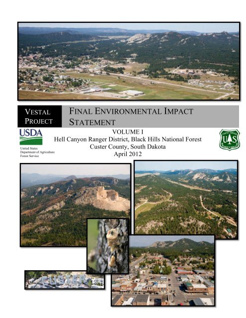
Aerial view of Crazy Horse<br />
Monument taken September<br />
13, 2011. Looking<br />
southwest.<br />
“Custer” sign, Custer, SD<br />
taken September 08, 2010.<br />
Aerial view of the city of Custer, SD<br />
taken September 16, 2011. Looking<br />
northwest.<br />
MPB pitch<br />
tube, with<br />
‘pitched’<br />
beetle.<br />
Aerial view of the Vestal<br />
project area (northwest)<br />
taken September 12, 2011.<br />
Aerial view of the city of<br />
Custer, SD taken September<br />
08, 2010. Looking north.<br />
The U.S. Department of Agriculture (USDA) prohibits discrimination in all its<br />
programs and activities on the basis of race, color, national origin, age, disability,<br />
and where applicable, sex, marital status, familial status, parental status, religion,<br />
sexual orientation, genetic information, political beliefs, reprisal, or because all or<br />
part of an individual’s income is derived from any public assistance program. (Not<br />
all prohibited bases apply to all programs.) Persons with disabilities who require<br />
alternative means for communication of program information (Braille, large-print,<br />
audiotape, etc.) should contact USDA’s TARGET Center at (202)720-2600 (voice<br />
and TDD).<br />
To file a complaint of discrimination, write to USDA, Director, Office of Civil<br />
Rights, 1400 Independence Avenue, S.W., Washington, D.C. 20250-9410, or call<br />
(800)795-3272 (voice) or (202)720-6382 (TDD). USDA is an equal opportunity<br />
provider and employer.
Vestal <strong>Final</strong> <strong>Environmental</strong> <strong>Impact</strong> <strong>Statement</strong><br />
Vestal Project<br />
<strong>Final</strong><br />
<strong>Environmental</strong> <strong>Impact</strong> <strong>Statement</strong><br />
Custer County, South Dakota<br />
Lead Agency: USDA Forest Service<br />
Cooperating Agencies: None<br />
Responsible Official: Lynn Kolund, District Ranger<br />
330 Mount Rushmore Road<br />
Custer, SD 57730<br />
(605) 673-4853<br />
For Information Contact: Kelly Honors, Team Leader<br />
330 Mount Rushmore Road<br />
Custer, SD 57730<br />
(605) 673-4853<br />
Abstract: The Hell Canyon Ranger District of the Black Hills National Forest has prepared a <strong>Final</strong><br />
<strong>Environmental</strong> <strong>Impact</strong> <strong>Statement</strong> (FEIS) in compliance with the National <strong>Environmental</strong> Policy Act<br />
(NEPA), the Healthy Forest Restoration Act (HFRA) and other relevant Federal and State laws and<br />
regulations. The Hell Canyon Ranger District proposes to implement multiple resource management<br />
actions within the Vestal project area on National Forest lands as guided by the Black Hills National<br />
Forest Land and Resource Management Plan as amended. The focus of the proposed action is to<br />
reduce mountain pine beetle risk and fire hazard on National Forest lands surrounding the City of<br />
Custer, SD. Two alternatives are considered in detail. Alternative 1 is the No Action Alternative.<br />
Alternative 2 is the proposed action and includes vegetation treatments designed primarily to reduce<br />
the potential for mountain pine beetle caused mortality within the Vestal project area. Proposed<br />
treatments are also designed to reduce fire hazard. This FEIS discloses the direct, indirect and<br />
cumulative effects resulting from these two alternatives. The preferred alternative is Alternative 2,<br />
with minor modification to proposed treatments on four units.<br />
i
Vestal <strong>Final</strong> <strong>Environmental</strong> <strong>Impact</strong> <strong>Statement</strong><br />
Table of Contents<br />
SUMMARY ........................................................................................................................ i<br />
CHAPTER 1: INTRODUCTION .................................................................................... 1<br />
Document Structure ...................................................................................................... 1<br />
Background .................................................................................................................... 1<br />
Location .......................................................................................................................... 4<br />
Management Direction ................................................................................................. 4<br />
Purpose and Need for Action ..................................................................................... 12<br />
Proposed Action........................................................................................................... 12<br />
Decision Framework ................................................................................................... 13<br />
Public Involvement ...................................................................................................... 13<br />
Issues ............................................................................................................................. 14<br />
CHAPTER 2: COMPARISON OF ALTERNATIVES, INCLUDING THE<br />
PROPOSED ACTION .................................................................................................... 16<br />
Alternatives Considered in Detail .............................................................................. 16<br />
Alternative 1 – No Action ........................................................................................ 16<br />
Alternative 2 – Proposed Action............................................................................. 16<br />
Design Criteria............................................................................................................. 24<br />
Monitoring ................................................................................................................... 24<br />
Alternatives Not Considered in Detail ....................................................................... 25<br />
Comparison of Alternatives........................................................................................ 27<br />
CHAPTER 3: AFFECTED ENVIRONMENT AND ENVIRONMENTAL<br />
CONSEQUENCES ......................................................................................................... 33<br />
Past, Present, and Reasonably Foreseeable Actions ................................................ 33<br />
Forest Vegetation......................................................................................................... 33<br />
Affected Environment ............................................................................................. 33<br />
Cover Types ............................................................................................................... 33<br />
Ponderosa Pine.......................................................................................................... 34<br />
Very Large Sized Trees .............................................................................................. 35<br />
Late Succession.......................................................................................................... 36<br />
Mountain Pine Beetle ................................................................................................ 36<br />
Hardwoods................................................................................................................. 37<br />
Table of Contents
Vestal <strong>Final</strong> <strong>Environmental</strong> <strong>Impact</strong> <strong>Statement</strong><br />
Spruce ........................................................................................................................ 37<br />
Meadows .................................................................................................................... 38<br />
<strong>Environmental</strong> Consequences ................................................................................ 38<br />
Alternative 1- No Action ......................................................................................... 38<br />
Cover Types ............................................................................................................... 38<br />
Ponderosa Pine.......................................................................................................... 38<br />
Very Large Sized Trees .............................................................................................. 41<br />
Late Succession.......................................................................................................... 42<br />
Hardwoods................................................................................................................. 42<br />
Spruce ........................................................................................................................ 42<br />
Meadows .................................................................................................................... 42<br />
Alternative 2 ............................................................................................................. 42<br />
Cover Types ............................................................................................................... 42<br />
Ponderosa Pine.......................................................................................................... 43<br />
Very Large Sized Trees .............................................................................................. 46<br />
Late Succession.......................................................................................................... 47<br />
Hardwoods................................................................................................................. 47<br />
Spruce ........................................................................................................................ 47<br />
Meadows .................................................................................................................... 47<br />
Cumulative Effects .................................................................................................. 48<br />
Ponderosa Pine.......................................................................................................... 48<br />
Late Succession and Very Large Sized Trees ............................................................ 48<br />
Mountain Pine Beetle Risk ........................................................................................ 49<br />
Hardwoods................................................................................................................. 49<br />
Spruce ........................................................................................................................ 50<br />
Meadows .................................................................................................................... 50<br />
Wildlife and Fish ......................................................................................................... 50<br />
Affected Environment ............................................................................................. 50<br />
Snags and Down Woody Material ............................................................................. 50<br />
Management Indicator Species (MIS) ....................................................................... 50<br />
Beaver (MIS) ............................................................................................................. 52<br />
White-tailed Deer (MIS) ............................................................................................ 52<br />
Golden-crowned Kinglet (MIS) ................................................................................. 53<br />
Table of Contents
Vestal <strong>Final</strong> <strong>Environmental</strong> <strong>Impact</strong> <strong>Statement</strong><br />
Black-backed Woodpecker (R2 Sensitive Species and MIS) .................................... 54<br />
Brown Creeper (MIS) ................................................................................................ 54<br />
Ruffed Grouse (MIS) ................................................................................................. 55<br />
Song Sparrow (MIS) .................................................................................................. 56<br />
Mountain Sucker (MIS and R2 Sensitive) ................................................................. 56<br />
Species of Local Concern (SOLC) ............................................................................. 57<br />
Atlantis Fritillary (SOLC) ......................................................................................... 58<br />
Tawny Crescent (SOLC) ........................................................................................... 58<br />
Callused Vertigo (SOLC) .......................................................................................... 59<br />
Mystery Vertigo (SOLC) ........................................................................................... 59<br />
Frigid Ambersnail (SOLC) ........................................................................................ 60<br />
Striate Disc (SOLC)................................................................................................... 60<br />
Sharp-shinned Hawk (SOLC) .................................................................................... 61<br />
Cooper’s Hawk (SOLC) ............................................................................................ 62<br />
Broad-winged Hawk (SOLC) .................................................................................... 62<br />
Northern Saw-whet Owl (SOLC) .............................................................................. 63<br />
Pygmy Nuthatch (SOLC) .......................................................................................... 64<br />
Northern Long-eared Myotis (SOLC) ....................................................................... 65<br />
Small-footed Myotis (SOLC) .................................................................................... 65<br />
Long-eared Myotis (SOLC)....................................................................................... 66<br />
Long-legged Myotis (SOLC)..................................................................................... 67<br />
Northern Flying Squirrel (SOLC) .............................................................................. 67<br />
Meadow Jumping Mouse (SOLC) ............................................................................. 68<br />
Mountain Goat (SOLC) ............................................................................................. 69<br />
Region 2 (R2) Sensitive Species ................................................................................. 70<br />
Bald Eagle (R2 Sensitive Species) ............................................................................ 71<br />
Northern Goshawk (R2 Sensitive Species) ............................................................... 71<br />
Black-backed Woodpecker (R2 Sensitive Species, MIS) ......................................... 71<br />
Northern Leopard Frog (R2 Sensitive Species) ......................................................... 71<br />
Black Hills Redbelly Snake (R2 Sensitive Species) .................................................. 72<br />
Fringed Myotis (R2 Sensitive Species) ..................................................................... 72<br />
Townsend’s Big-eared Bat (R2 Sensitive Species) ................................................... 72<br />
Black-tailed Prairie Dog (R2 Sensitive Species) ....................................................... 73<br />
Table of Contents
Vestal <strong>Final</strong> <strong>Environmental</strong> <strong>Impact</strong> <strong>Statement</strong><br />
Mountain Sucker (R2 Sensitive Species, MIS) ......................................................... 73<br />
Hoary Bat (R2 Sensitive Species) ............................................................................. 74<br />
American Marten (R2 Sensitive Species) .................................................................. 74<br />
Flammulated Owl (R2 Sensitive Species) ................................................................. 74<br />
Cooper’s Mountain Snail (R2 Sensitive Species) ...................................................... 75<br />
Regal Fritillary Butterfly (R2 Sensitive Species) ...................................................... 75<br />
Demand Species ......................................................................................................... 76<br />
Rocky Mountain Elk (Demand Species) ................................................................... 76<br />
Merriam’s Wild Turkey (Demand Species) .......................................................... 77<br />
Migratory Birds ......................................................................................................... 77<br />
Golden Eagle (Migratory Bird) ................................................................................. 77<br />
<strong>Environmental</strong> Consequences ................................................................................ 78<br />
Snags and Down Woody Material ............................................................................. 78<br />
Management Indicator Species (MIS) ....................................................................... 79<br />
Species of Local Concern (SOLC) ............................................................................. 85<br />
Threatened and Endangered Species ........................................................................ 94<br />
Region 2 (R2) Sensitive Species ................................................................................. 95<br />
Summary of Effects on Sensitive Species ................................................................ 95<br />
Demand Species ....................................................................................................... 106<br />
Rocky Mountain Elk (Demand Species) .................................................................. 106<br />
Alternative Effects Summary .................................................................................. 106<br />
Merriam’s Wild Turkey (Demand Species) ............................................................. 107<br />
Alternative Effects Summary .................................................................................. 107<br />
Cumulative Effects .................................................................................................. 107<br />
Migratory Birds ....................................................................................................... 107<br />
Golden Eagle (Migratory Bird) ............................................................................... 107<br />
Fire and Fuels ............................................................................................................ 108<br />
Affected Environment ........................................................................................... 108<br />
Custer Community Wildfire Protection Plan (CWPP) ............................................ 108<br />
Condition Class and Fire Regime ........................................................................... 109<br />
Fire Risk .................................................................................................................. 109<br />
Values at Risk .......................................................................................................... 110<br />
Fire Hazard ............................................................................................................. 111<br />
Table of Contents
Vestal <strong>Final</strong> <strong>Environmental</strong> <strong>Impact</strong> <strong>Statement</strong><br />
Air Quality ............................................................................................................... 113<br />
<strong>Environmental</strong> Consequences .............................................................................. 114<br />
Alternative 1 ........................................................................................................... 114<br />
Direct and Indirect Effects .................................................................................... 115<br />
Air Quality ............................................................................................................... 117<br />
Alternative 2 ........................................................................................................... 117<br />
Direct and Indirect Effects .................................................................................... 117<br />
Air Quality ............................................................................................................... 120<br />
Cumulative Effects ................................................................................................ 121<br />
Air Quality ............................................................................................................... 122<br />
Botany, Rangeland, and Noxious Weeds ................................................................. 122<br />
Affected Environment ........................................................................................... 122<br />
Botany ...................................................................................................................... 122<br />
Species of Local Concern (SOLC) ........................................................................ 123<br />
Region 2 (R2) Sensitive Species ............................................................................ 123<br />
Range ....................................................................................................................... 124<br />
Noxious Weeds ......................................................................................................... 124<br />
<strong>Environmental</strong> Consequences .............................................................................. 124<br />
Alternative 1 ........................................................................................................... 124<br />
Botany ...................................................................................................................... 124<br />
Range ....................................................................................................................... 126<br />
Noxious Weeds ......................................................................................................... 127<br />
Alternative 2............................................................................................................... 127<br />
Botany ...................................................................................................................... 127<br />
Range ....................................................................................................................... 130<br />
Noxious Weeds ......................................................................................................... 131<br />
Cumulative Effects ................................................................................................ 132<br />
Minerals and Geologic Resources ............................................................................ 133<br />
Affected Environment ........................................................................................... 133<br />
<strong>Environmental</strong> Consequences .............................................................................. 133<br />
Direct, Indirect, and Cumulative Effects for All Alternatives .......................... 133<br />
Lands and Special Uses ............................................................................................. 134<br />
Affected Environment ........................................................................................... 134<br />
Table of Contents
Vestal <strong>Final</strong> <strong>Environmental</strong> <strong>Impact</strong> <strong>Statement</strong><br />
<strong>Environmental</strong> Consequences .............................................................................. 134<br />
Alternative 1 ........................................................................................................... 134<br />
Alternative 2 ........................................................................................................... 135<br />
Cumulative Effects ................................................................................................ 135<br />
Heritage Resources .................................................................................................... 135<br />
Affected Environment ........................................................................................... 135<br />
<strong>Environmental</strong> Consequences .............................................................................. 137<br />
Alternative 1 ........................................................................................................... 137<br />
Alternative 2 ........................................................................................................... 137<br />
Cumulative Effects ................................................................................................ 137<br />
Scenery ....................................................................................................................... 138<br />
Affected Environment ........................................................................................... 138<br />
<strong>Environmental</strong> Consequences .............................................................................. 139<br />
Alternative 1 ........................................................................................................... 139<br />
Alternative 2 ........................................................................................................... 139<br />
Cumulative Effects ................................................................................................ 142<br />
Transportation ........................................................................................................... 143<br />
Affected Environment ........................................................................................... 143<br />
<strong>Environmental</strong> Consequences .............................................................................. 144<br />
Alternative 1 ........................................................................................................... 144<br />
Cumulative Effects ................................................................................................ 145<br />
Recreation .................................................................................................................. 146<br />
Affected Environment ........................................................................................... 146<br />
Recreation Opportunity Spectrum (ROS) ................................................................ 146<br />
Developed Recreation .............................................................................................. 146<br />
Dispersed Recreation .............................................................................................. 146<br />
Recreation Special Uses .......................................................................................... 147<br />
Motorized Recreation .............................................................................................. 147<br />
<strong>Environmental</strong> Consequences .............................................................................. 147<br />
Alternative 1 ........................................................................................................... 147<br />
Developed Recreation .............................................................................................. 148<br />
Dispersed Recreation .............................................................................................. 148<br />
Recreation Special Uses .......................................................................................... 148<br />
Table of Contents
Vestal <strong>Final</strong> <strong>Environmental</strong> <strong>Impact</strong> <strong>Statement</strong><br />
Alternative 2 ........................................................................................................... 148<br />
Travel Management ................................................................................................. 149<br />
Mickelson Trail ........................................................................................................ 149<br />
Cumulative Effects ................................................................................................ 149<br />
Soils and Hydrology .................................................................................................. 150<br />
Field Surveys .......................................................................................................... 150<br />
Affected Environment - Soils ................................................................................ 150<br />
Soil Health Assessment ............................................................................................ 151<br />
Soil Erosion ............................................................................................................. 151<br />
Soil Compaction ...................................................................................................... 151<br />
Nutrient Removal ..................................................................................................... 151<br />
<strong>Environmental</strong> Consequences - Soils ................................................................... 151<br />
Soil Erosion – Direct and Indirect Effects............................................................... 151<br />
Alternative 1 ........................................................................................................... 152<br />
Alternative 2 ........................................................................................................... 152<br />
Soil Compaction – Direct and Indirect Effects ........................................................ 152<br />
Alternative 1 ........................................................................................................... 152<br />
Alternative 2 ........................................................................................................... 152<br />
Nutrient Removal – Direct and Indirect Effects ...................................................... 153<br />
Alternative 1 ........................................................................................................... 153<br />
Alternative 2 ........................................................................................................... 153<br />
Soil Heating – Direct and Indirect Effects .............................................................. 153<br />
Alternative 1 ........................................................................................................... 153<br />
Alternative 2 ........................................................................................................... 153<br />
Cumulative Effects - Soils ....................................................................................... 154<br />
Nutrient Removal ..................................................................................................... 154<br />
Soil Heating ............................................................................................................. 154<br />
Soil Erosion ............................................................................................................. 154<br />
Soil Compaction ...................................................................................................... 155<br />
Affected Environment – Hydrology ..................................................................... 155<br />
Watersheds............................................................................................................... 155<br />
Floodplains .............................................................................................................. 157<br />
Wetlands and Riparian ............................................................................................ 157<br />
Table of Contents
Vestal <strong>Final</strong> <strong>Environmental</strong> <strong>Impact</strong> <strong>Statement</strong><br />
Lakes ........................................................................................................................ 157<br />
Streams .................................................................................................................... 157<br />
Beneficial Uses ........................................................................................................ 158<br />
Streamflow Regime .................................................................................................. 159<br />
Stream Health .......................................................................................................... 159<br />
Connected Disturbed Area (CDA) ........................................................................... 160<br />
Water Quality .......................................................................................................... 160<br />
<strong>Environmental</strong> Consequences - Hydrology ......................................................... 160<br />
Aquatic Ecosystems ............................................................................................... 161<br />
Sediment – Direct and Indirect Effects .................................................................... 161<br />
Alternative 1 ........................................................................................................... 161<br />
Alternative 2 ........................................................................................................... 161<br />
Bed and Bank Stability – Direct and Indirect Effects .............................................. 162<br />
Alternative 1 ........................................................................................................... 162<br />
Alternative 2 ........................................................................................................... 162<br />
Stream Flow Regime – Direct and Indirect Effects ................................................. 162<br />
Alternative 1 ........................................................................................................... 162<br />
Alternative 2 ........................................................................................................... 163<br />
Temperature and Oxygen – Direct and Indirect Effects .......................................... 163<br />
Alternative 1 ........................................................................................................... 163<br />
Alternative 2 ........................................................................................................... 163<br />
Water Purity – Direct and Indirect Effects .............................................................. 163<br />
Alternative 1 ........................................................................................................... 163<br />
Alternative 2 ........................................................................................................... 163<br />
Aquatic Life – Direct and Indirect Effects ............................................................... 164<br />
Alternative 1 ........................................................................................................... 164<br />
Alternative 2 ........................................................................................................... 164<br />
Riparian Ecosystems – Direct and Indirect Effects ................................................. 164<br />
Alternative 1 ........................................................................................................... 164<br />
Alternative 2 ........................................................................................................... 164<br />
Wetlands – Direct and Indirect Effects .................................................................... 164<br />
Alternative 1 ........................................................................................................... 164<br />
Alternative 2 ........................................................................................................... 165<br />
Table of Contents
Vestal <strong>Final</strong> <strong>Environmental</strong> <strong>Impact</strong> <strong>Statement</strong><br />
Floodplains – Direct and Indirect Effects ............................................................... 165<br />
Alternative 1 ........................................................................................................... 165<br />
Alternative 2 ........................................................................................................... 165<br />
Watershed Condition Class – Direct and Indirect Effects ...................................... 165<br />
Alternative 1 ........................................................................................................... 165<br />
Alternative 2 ........................................................................................................... 165<br />
Cumulative Effects - Hydrology ........................................................................... 165<br />
Sediment................................................................................................................... 166<br />
Bed and Bank Stability ............................................................................................ 166<br />
Stream Flow Regimes .............................................................................................. 166<br />
Temperature and Oxygen ........................................................................................ 166<br />
Water Purity ............................................................................................................ 167<br />
Aquatic Life.............................................................................................................. 167<br />
Riparian Ecosystems................................................................................................ 167<br />
Wetlands .................................................................................................................. 167<br />
Floodplains .............................................................................................................. 167<br />
Watershed Condition Class ..................................................................................... 167<br />
Best Management Practices (BMP) Effectiveness .............................................. 167<br />
Socio-Economics ........................................................................................................ 168<br />
Short Term Uses and Long Term Productivity ...................................................... 172<br />
Unavoidable Adverse Effects ................................................................................... 172<br />
Irreversible and Irretrievable Commitments of Resources .................................. 172<br />
<strong>Environmental</strong> Justice .............................................................................................. 173<br />
Other Required Disclosures ..................................................................................... 173<br />
CHAPTER 4: CONSULTATION AND COORDINATION .................................... 174<br />
CHAPTER 5: LITERATURE CITED and GLOSSARY ......................................... 181<br />
Literature Cited ......................................................................................................... 181<br />
Glossary ...................................................................................................................... 194<br />
Index ........................................................................................................................... 210<br />
Table of Contents
Vestal <strong>Final</strong> <strong>Environmental</strong> <strong>Impact</strong> <strong>Statement</strong><br />
List of Figures<br />
Figure 1. At-Risk Communities (ARC) with 3-Mile WUI Boundary .............................. 11<br />
Figure 2. Ponderosa Pine Structural Stages-Existing Condition. ..................................... 29<br />
Figure 3. Ponderosa Pine Structural Stages - Alt. 1-No Action. ...................................... 29<br />
Figure 4. Ponderosa Pine Structural Stages - Alt. 2-Proposed Action. ............................ 29<br />
Figure 5. MPB Risk Rating (in acres)-Existing Condition. .............................................. 30<br />
Figure 6. MPB Risk Rating (in acres)-Alternative 2. ....................................................... 30<br />
Figure 7. Fire Hazard Rating Summary for Vestal Project Area. ..................................... 31<br />
Figure 8. Fire History in and around the Project Area and the Point Fire History within<br />
the Project Boundary....................................................................................................... 110<br />
Figure 9. At-Risk Communities (ARC) with 3 Mile WUI, and Structures Located within<br />
the Project Area............................................................................................................... 111<br />
Figure 10. Existing Condition Fire Hazard Rating. ........................................................ 113<br />
Figure 11. Alternative 1 Fire Hazard Rating (Year 2018). ............................................. 116<br />
Figure 12. Alternative 2 Fire Hazard Rating (Year 2018). ............................................. 118<br />
Figure 13. Fire Hazard Rating by Alternative. ............................................................... 119<br />
List of Tables<br />
Table 1. Vestal Project Area Legal Description ................................................................. 4<br />
Table 2. Management Area Direction in the Vestal Project Area-on National Forest<br />
System Lands Only (60% of total lands within the project boundary) ............................... 5<br />
Table 3. Comparison of Cover Types ............................................................................... 28<br />
Table 4. Comparison of Ponderosa Pine Structural Stages............................................... 28<br />
Table 5. MPB Risk Rating by Alternative ........................................................................ 30<br />
Table 6. Fire Hazard Rating Acres by Alternative at Year 2018-For Entire Project Area 31<br />
Table 7. Alternative 2 Proposed Mechanical Vegetation Treatments .............................. 32<br />
Table 8. Alternative 2 Proposed Fuel Reduction Treatments ........................................... 32<br />
Table 9. Total Miles of Forest Service Roads on National Forest Land within the Project<br />
Area, by Alternative .......................................................................................................... 32<br />
Table 10. Designation of National Forest System Roads within the Project Area ........... 32<br />
Table 11. Existing Cover Types in the Vestal Project Area ............................................. 33<br />
Table 12. Existing Ponderosa Pine Structural Stages (SS) in the Vestal Project Area ..... 34<br />
Table of Contents
Vestal <strong>Final</strong> <strong>Environmental</strong> <strong>Impact</strong> <strong>Statement</strong><br />
Table 13. Structural Stage (SS) Objective Percentages for Ponderosa Pine in MAs 4.1,<br />
5.1, and 5.4 across the Black Hills National Forest .......................................................... 34<br />
Table 14. Existing Pine Structural Stage Acres and Percentages in MA 4.1.................... 35<br />
Table 15. Existing Pine Structural Stage Acres and Percentages in MA 5.1.................... 35<br />
Table 16. Existing Pine Structural Stage Acres and Percentages in MA 5.4.................... 35<br />
Table 17. Existing Percentages of Very Large Sized Pine Acres by Management Area . 36<br />
Table 18. MPB Risk Rating by Pine Structural Stage ...................................................... 37<br />
Table 19. Current MPB Risk Rating for Ponderosa Pine in Vestal .................................. 37<br />
Table 20. Alternative 1 Pine Structural Stages in the Vestal Project Area, Projected to<br />
Year 2018 and Compared to Existing Condition .............................................................. 38<br />
Table 21. Alternative 1 Pine SS in MA 4.1, Forest-Wide ................................................ 40<br />
Table 22. Alternative 1 Pine SS in MA 5.1, Forest-Wide ................................................ 40<br />
Table 23. Alternative 1 Pine SS in MA 5.4, Forest-Wide ................................................ 41<br />
Table 24. Alternative 1 Acres of SS4 with an Average Tree Size of Very Large at Year<br />
2018................................................................................................................................... 41<br />
Table 25. Alternative 1 Percentage of SS4 with an Average Tree Size of Very Large at<br />
Year 2018 .......................................................................................................................... 41<br />
Table 26. Pine Structural Stages by Alternative within the Vestal Project Area .............. 43<br />
Table 27. MPB Risk Rating - Alternative 2 Compared to Existing Condition................. 44<br />
Table 28. Forest-Wide Management Area 4.1 Pine Structural Stages by Alternative ..... 45<br />
Table 29. Forest-Wide Management Area 5.1 Pine Structural Stages by Alternative ..... 45<br />
Table 30. Forest-Wide Management Area 5.4 Pine Structural Stages by Alternative ..... 46<br />
Table 31. All Alternatives: Acres of SS4 with an Average Tree Size of Very Large at<br />
Year 2018 .......................................................................................................................... 46<br />
Table 32. All Alternatives Percentage of SS4 with an Average Tree Size of Very Large at<br />
Year 2018 .......................................................................................................................... 47<br />
Table 33. MIS List and Rationale for Inclusion in Project-Level Analysis ...................... 51<br />
Table 34. Current Screening Cover in the Vestal Project Area on Forest Service Land .. 53<br />
Table 35. SOLC List and Rationale for Project-Level Analysis ...................................... 57<br />
Table 36. Summary of Effects on MIS ............................................................................. 79<br />
Table 37. Summary of Effects to SOLC ........................................................................... 85<br />
Table 38. Summary of Effects on R2 Sensitive Species ................................................... 95<br />
Table 39. Fire History Occurrence and the Size of the Fires from 1950 to Present ....... 109<br />
Table 40. Existing Fire Hazard within Whole Project Area and within 3 Mile WUI. .... 112<br />
Table of Contents
Vestal <strong>Final</strong> <strong>Environmental</strong> <strong>Impact</strong> <strong>Statement</strong><br />
Table 41. Fire Hazard Rating for Existing Condition and No Action at Year 2018....... 116<br />
Table 42. Fire Hazard Rating within WUI - No Action at Year 2018 ............................ 116<br />
Table 43. Fire Hazard Rating by Alternative in Whole Project Area at Year 2018 ....... 119<br />
Table 44. Fire Hazard Rating by Alternative in WUI at Year 2018 ............................... 119<br />
Table 45. Known State Listed and Species of Insufficient Information ......................... 123<br />
Table 46. Existing Transportation System in the Vestal Area ........................................ 144<br />
Table 47. Travel Management Designation Miles and Density within the Vestal Area 144<br />
Table 48. Road Mileage and Density by Alternative ...................................................... 145<br />
Table 49. Soils in the Vestal Project Area (USDA NRCS 2011) ................................... 150<br />
Table 50. HUC 12 Watershed within the Vestal Project Area ....................................... 156<br />
Table 51. Stream Mileages within the Vestal Project Area ............................................ 158<br />
Table 52. Vestal Stream with Additional Beneficial Uses ............................................. 158<br />
Table 53. Watersheds analyzed for Cumulative Effects ................................................. 166<br />
Table 54. Area Population Based on 2000 and 2010 Census ......................................... 169<br />
Table 55. Percent Population by Ethnicity Based on the 2010 Census .......................... 169<br />
Table 56. Economic Well-Being Based on 2006-2010 Census ...................................... 170<br />
Table of Contents
Commonly Used Acronyms and Abbreviations<br />
APE Area of Potential Effect<br />
ARC At-Risk-Community<br />
BA Basal Area<br />
BABE,<br />
BA/BE<br />
Biological<br />
Assessment/Biological<br />
Evaluation<br />
BCC Birds of Conservation<br />
Concern<br />
BCR Bird Conservation Region<br />
BHNF Black Hills National Forest<br />
BHNF<br />
LRMP<br />
Black Hills National Forest<br />
Revised Land and Resource<br />
Management Plan<br />
BMP Best Management Practices<br />
CCF Hundred Cubic Feet<br />
CDA Connected Disturbed Areas<br />
CEQ Council on <strong>Environmental</strong><br />
Quality<br />
CFR Code of Federal Regulations<br />
CWD Coarse Woody Debris<br />
CWPP Community Wildfire<br />
Protection Plan<br />
dbh Diameter at Breast Height<br />
DENR Department of Environment<br />
and Natural Resources<br />
EIS <strong>Environmental</strong> <strong>Impact</strong><br />
<strong>Statement</strong><br />
EPA <strong>Environmental</strong> Protection<br />
Agency<br />
FEMA Federal Emergency<br />
Management Agency<br />
FPS&G Forest Plan Standards and<br />
Guidelines<br />
FRCC Fire Regime Condition<br />
Class<br />
FSM Forest Service Manual<br />
FSR Forest Service Road<br />
FY Fiscal Year<br />
GIS Geographic Information<br />
Systems<br />
HFRA Health Forest Restoration<br />
Act<br />
HUC Hydrologic Unit Code<br />
IDT, ID Interdisciplinary Team<br />
Team<br />
LRMP Land and Resource<br />
Management Plan<br />
MA Management Area<br />
MBBH Monitoring Birds of the<br />
Black Hills<br />
MIS Management Indicator<br />
Species<br />
MPB Mountain Pine Beetle<br />
MVUM Motor Vehicle Use Map<br />
NEPA National <strong>Environmental</strong><br />
Policy Act<br />
NFMA National Forest<br />
Management Act<br />
NFS National Forest System<br />
NFSR National Forest System<br />
Road<br />
NHPA National Historic<br />
Preservation Act<br />
NRHP National Register of<br />
Historic Places
OHV Off Highway Vehicle<br />
POL Products Other than Logs<br />
R2 Forest Service Region 2<br />
(Rocky Mountain Region)<br />
RIS Resource Information<br />
System<br />
RMBO Rocky Mountain Bird<br />
Observatory<br />
RMRS Rocky Mountain Research<br />
Station<br />
ROS Recreation Opportunity<br />
Spectrum<br />
ROW Right-of-way<br />
RX Prescribed Fire<br />
SD South Dakota<br />
SDDENR South Dakota Department<br />
of Environment and Natural<br />
Resources<br />
SDGFP South Dakota Game Fish<br />
and Parks<br />
SDNHP South Dakota Natural<br />
Heritage Program<br />
SHPO State Historic Preservation<br />
Office<br />
SHR Stream Health Rating<br />
SIO Site Integrity Objective<br />
SOLC Species of Local Concern<br />
SOPA Schedule of Proposed<br />
Action<br />
SS Structural Stage<br />
SUP Special Use Permits<br />
TES Threatened, Endangered, &<br />
Sensitive Species<br />
THPO Tribal Historic Preservation<br />
Office<br />
USC United States Code<br />
USDA United States Department of<br />
Agriculture<br />
USFS United States Department of<br />
Agriculture Forest Service<br />
USFWS United States Fish and<br />
Wildlife Service<br />
USGS United States Geological<br />
Survey<br />
WCP Watershed Conservation<br />
Practice<br />
WIZ Water Influence Zone<br />
WUI Wildland Urban Interface
Vestal <strong>Final</strong> <strong>Environmental</strong> <strong>Impact</strong> <strong>Statement</strong> Summary<br />
SUMMARY<br />
The Hell Canyon Ranger District of the Black Hills National Forest proposes to<br />
implement multiple resource management actions within the Vestal project area as<br />
guided by the Black Hills National Forest Land and Resource Management Plan and<br />
Phase II Amendment (Forest Plan). Due to the existing epidemic of mountain pine<br />
beetles (MPB) in the project area (see Appendix H), the Vestal project was developed<br />
under the authorities of the Healthy Forest Restoration Act (HFRA). The proposed action<br />
includes commercial and non-commercial vegetation treatments and prescribed burning<br />
to reduce mountain pine beetle risk and fire hazard on National Forest lands surrounding<br />
the City of Custer, SD. Proposed resource management actions apply only to National<br />
Forest lands.<br />
The Vestal project area surrounds the city of Custer, South Dakota within Custer County<br />
(see Map 1 in Appendix A). The project area includes approximately 43,516 acres;<br />
25,823 (60%) of which are National Forest System lands and 17,693 (40%) which are<br />
private lands (including City or County properties). Given the project location around the<br />
City of Custer, there are extensive private dwellings, businesses, and government offices<br />
in this project area. The Hell Canyon Ranger District office and shop, as well as the<br />
Black Hills National Forest Supervisor’s Office, are also located within the project area.<br />
High use developed recreation sites occur on private, State and Federal lands within or<br />
adjacent to the project area. Sites within the project boundary include; approximately<br />
eight miles of the Mickelson trail, Bismarck Lake campground, Crazy Horse Mountain,<br />
and numerous private campgrounds. Other recreation areas adjacent to the project area<br />
include Custer State Park.<br />
All state and county roads which access the City of Custer are within the project area for<br />
at least a portion of their length. Therefore, all visitors to Custer will travel through the<br />
project area.<br />
The focus of the proposed action is to treat vegetation on a broad landscape scale to<br />
reduce the threat to ecosystem components from the existing MPB epidemic. The<br />
proposed action would also reduce fire hazard and consequently, the potential for highintensity,<br />
large-scale wildfire. Implications of continued spread of this MPB epidemic<br />
include increased tree mortality across the landscape, on both National Forest and private<br />
lands. Consequently, the further accumulation of hazardous fuels would increase the<br />
potential for severe large-scale wildfires threatening forest resources and other values<br />
within the area including major changes in scenery and alteration of wildlife habitat.<br />
Schmid et al. 2007, states “the most important aspect of managing mature ponderosa pine<br />
stands on the Black Hills National Forest is minimizing MPB-caused mortality.”<br />
This action is needed because the Vestal project area is within an expanding mountain<br />
pine beetle epidemic. The Black Hills National Forest, Forest Supervisor, Craig Bobzien,<br />
has determined that a MPB epidemic is occurring in the project area (Appendix H). Over<br />
the past 3-4 years there has been a rapidly growing amount of MPB caused mortality in<br />
the southern Black Hills around the City of Custer. All measures of MPB activity<br />
indicate a rapidly growing MPB epidemic with a substantial increase in tree mortality<br />
over the past 3 years. Approximately 61% of ponderosa pine stands on National Forest<br />
lands in the project area are at high risk for MPB caused mortality.<br />
i
Vestal <strong>Final</strong> <strong>Environmental</strong> <strong>Impact</strong> <strong>Statement</strong> Summary<br />
At this time, there are larger pockets of MPB activity in the northern and western parts of<br />
the project area. The southern parts of the project are less impacted at this time, but<br />
beetle activity is occurring there at a rapidly growing rate on both National Forest and<br />
private lands. Approximately 17,693 acres (40%) of the project area is private land with<br />
over 7,000 of those acres being forested. Private landowners are experiencing MPB<br />
caused mortality on their property and many are taking actions such as thinning,<br />
sanitation, cut and chunk, and individual tree spraying. Many private landowners are<br />
worried about the potential spread of MPB from National Forest lands to their own. This<br />
project would reduce MPB risk on National forest lands and would reduce the potential<br />
for MPB spread onto private lands.<br />
The Hell Canyon Ranger District held a public meeting to discuss the Vestal project on<br />
Wednesday, May 11, 2011 at the Custer High School, Custer, SD. The proposed action<br />
was described in a scoping document (April 20, 2011) and mailed to approximately 149<br />
individuals, tribal representatives, groups, government entities and other interested<br />
members of the public. The proposed action includes vegetation treatments, prescribed<br />
fire, and fuel treatments on National Forest lands only.<br />
The Forest Service evaluated the following alternatives:<br />
ii<br />
Alternative 1 – No Action: The National <strong>Environmental</strong> Policy Act<br />
(NEPA) requires the study of the ‘No Action’ alternative as a basis<br />
for comparing effects of the proposed action and other alternatives.<br />
The ‘No Action’ alternative assumes no implementation of any<br />
elements of the proposed action or other action alternatives would<br />
take place within the Vestal project area. This alternative represents<br />
no attempt to actively respond to the purpose and need for action or<br />
the issues identified during scoping. For example, there would be no<br />
effort to modify existing vegetation or related fuels conditions in the<br />
project area; current timber sales, fire suppression efforts, noxious<br />
weeds treatments and regular system road maintenance would<br />
continue on National Forest lands.<br />
Alternative 2 – Proposed Action: The proposed action is designed to<br />
address the purpose of and need for action. Strategies proposed to<br />
reduce mountain pine beetle caused mortality include, mechanical<br />
thinning to reduce density, and sanitation which removes green trees<br />
that have live beetle brood in them. This alternative would be most<br />
effective if implemented immediately. In the Black Hills, stands that<br />
are less than 80 ft 2 /acre basal area are at a reduced risk. Therefore,<br />
reducing stand basal area is a preventative treatment. Sanitation is<br />
considered a suppression strategy because it directly removes beetle<br />
larvae from the forest, directly reducing beetle populations. A total of<br />
up to 25,449 acres, which includes pine encroachment, hardwood<br />
release, hardwood conversion, and sanitation, of the project area<br />
would receive vegetation treatments under this alternative. Fuel<br />
treatments, including thinning, deadfall (mechanical treatment of<br />
down logs and branches), and prescribed burning, would occur on up<br />
to 25,634 acres. The proposed action includes the following
Vestal <strong>Final</strong> <strong>Environmental</strong> <strong>Impact</strong> <strong>Statement</strong> Summary<br />
modifications to the transportation system in the project area: 0.6<br />
miles of unauthorized road is needed for access and would be<br />
converted to a system road then closed following use; and 0.9 miles of<br />
system road would be closed to protect resources either with physical<br />
closures or gates. Refer to Appendix A for proposed action maps for<br />
both vegetation treatments and fuels treatments, as well as the<br />
transportation map noting proposed adjustments to the transportation<br />
system.<br />
The deciding official will review the environmental analysis, all supporting documents<br />
and public input in order to make the following decisions:<br />
(1) Whether or not active management is appropriate in the Vestal project area at this<br />
time and if so, what actions should occur.<br />
(2) Whether the information in this analysis is sufficient to make a reasoned decision.<br />
iii
Vestal <strong>Final</strong> <strong>Environmental</strong> <strong>Impact</strong> <strong>Statement</strong> Chapter 1<br />
CHAPTER 1: INTRODUCTION<br />
Document Structure<br />
The Forest Service has prepared this <strong>Final</strong> <strong>Environmental</strong> <strong>Impact</strong> <strong>Statement</strong> (FEIS) in<br />
compliance with the National <strong>Environmental</strong> Policy Act (NEPA), the Healthy Forest<br />
restoration Act (HFRA) and other relevant Federal and State laws and regulations. This<br />
Draft <strong>Environmental</strong> <strong>Impact</strong> <strong>Statement</strong> discloses the direct, indirect, and cumulative<br />
environmental impacts that would result from the proposed action and no action<br />
alternatives. All numbers and figures are approximate measures based on known project<br />
conditions. The document is organized into five chapters:<br />
• Chapter 1: Introduction: The section includes information on the history of the<br />
project proposal, the purpose of and need for the project, and the agency’s proposal<br />
for achieving that purpose and need. This section also details how the Forest Service<br />
informed the public of the proposal and how the public responded.<br />
• Chapter 2: Alternatives, including the Proposed Action: This section provides a<br />
more detailed description of the agency’s proposed action. A summary comparison<br />
of the proposed action and no action alternatives is also provided in this chapter.<br />
• Chapter 3: Affected Environment and <strong>Environmental</strong> Consequences: This section<br />
describes the environmental effects of implementing the proposed action and no<br />
action alternatives. This analysis is organized by resource area (i.e. Silviculture,<br />
Wildlife, Recreation). The effects of the No Action alternative provide a baseline for<br />
evaluating and comparing to the proposed action alternative.<br />
• Chapter 4: Consultation and Coordination: This section provides a list of preparers,<br />
and also a list of agencies, groups and persons consulted during the development of<br />
the Vestal <strong>Final</strong> <strong>Environmental</strong> <strong>Impact</strong> <strong>Statement</strong> (FEIS).<br />
• Chapter 5: Literature Cited and Glossary<br />
• Index<br />
• Appendices: The appendices provide more detailed information to support the<br />
analyses presented in the environmental assessment.<br />
Additional documentation, including more detailed analyses of project-area resources,<br />
may be found in the project planning record located at the Hell Canyon Ranger District<br />
Office in Custer, South Dakota.<br />
Background<br />
The Vestal project area surrounds the city of Custer, South Dakota, encompassing a large<br />
amount (40%) of private land. The private, or non-Forest Service, lands are concentrated<br />
within the city limits, but occur as scattered parcels throughout the whole project area<br />
(see maps in Appendix A). There are extensive private dwellings, businesses, and<br />
government offices within the project area. These structures also occur throughout the<br />
project area (see Maps 6 and 7 in Appendix A). There are many high-use developed<br />
1
Vestal <strong>Final</strong> <strong>Environmental</strong> <strong>Impact</strong> <strong>Statement</strong> Chapter 1<br />
recreational sites that occur on private, state, and federal lands within or adjacent to the<br />
project area. All visitors to the City of Custer will travel through the project area.<br />
The Black Hills National Forest, Forest Supervisor, Craig Bobzien, has determined that a<br />
MPB epidemic is occurring in the project area (Appendix H). Over the past 3-4 years<br />
there has been a rapidly growing amount of beetle caused mortality in the southern Black<br />
Hills around the City of Custer, on both National Forest and private lands. All measures<br />
of MPB activity indicate a rapidly growing MPB epidemic with a substantial increase in<br />
tree mortality over the past 3 years. Approximately 61% of ponderosa pine stands, on<br />
National Forest lands in the project area are at high risk for MPB caused mortality.<br />
2<br />
February 2009-Hwy16/385, mountain top in photo is approximately one mile in<br />
distance. MPB killed trees appear red/brown along the horizon.<br />
September 2011-Hwy16/385, from approximately same location as photo above. MPB<br />
killed trees appear red/brown along the horizon.
Vestal <strong>Final</strong> <strong>Environmental</strong> <strong>Impact</strong> <strong>Statement</strong> Chapter 1<br />
At this time, there are larger pockets of beetle activity in the northern and western parts<br />
of the project area. The southern parts of the project are less impacted at this time, but<br />
beetle activity is occurring there at a rapidly growing rate. The primary management tool<br />
for reducing MPB-caused mortality is to remove the infested trees and to reduce the<br />
overall density of the remaining trees through mechanical thinning.<br />
Private land is also being impacted by the MPB epidemic. Approximately 7,000 acres of<br />
private forested land occurs within the Vestal project area. Many land owners are taking<br />
steps to protect their properties by thinning stands, removing trees infested with beetles<br />
(sanitation), cutting and chunking of infested trees, and spraying individual trees to<br />
protect them against the MPB epidemic. Land owners have voiced their concern about<br />
adjacent National Forest lands infested with MPB and the continuing spread onto their<br />
own land. Mountain pine beetles are moving across all ownerships within this project<br />
area.<br />
Fire hazard is currently high to very high on approximately 84% of National Forest lands<br />
in the project area. This signifies substantial potential for large-scale, high-intensity<br />
wildfires to occur. Such fires could threaten lives and property, as well as, resource<br />
values.<br />
Custer County prepared a Community Wildfire Protection Plan (CWPP) which was<br />
approved by resolution in 2011 (resolution 2011-7). The CWPP identified the City of<br />
Custer at-risk community (ARC) as an urban interface environment with a high density of<br />
structures and infrastructure. In many areas the structures lack defensible fire protection<br />
space. There is a community watershed for municipal water source at high risk of fire<br />
impacts. Also there is a high potential for economic loss, and likelihood for loss of<br />
housing and businesses in the event of a wildfire. The Custer County CWPP identifies a<br />
3 mile radius from the city limits of the City of Custer as a Community at Risk boundary.<br />
This 3 mile ARC radius of the city limits is the Wildland Urban Interface (WUI).<br />
Healthy Forest Restoration Act (HFRA)<br />
The Healthy Forest Restoration Act (HFRA) was signed by President Bush in 2003 (H.R.<br />
1904) for the purpose of expediting hazardous fuels reduction and forest restoration<br />
projects on Federal lands at risk of wildland fire or insect and disease epidemics.<br />
The HFRA is comprised of a variety of provisions to expedite hazardous fuels reductions<br />
on specific types of National Forest land. The Vestal Project is an authorized hazardous<br />
fuels reduction project under Section 102(a)(4). The project area meets the qualifications<br />
because of the existing MPB epidemic occurring within and adjacent to the project area,<br />
which poses a significant threat to resource values on National Forest and private lands<br />
(see Appendix H). The Vestal project will be analyzed under the provisions of the<br />
HFRA, Section 102(a)(4).<br />
The HFRA provided expedited procedures for complying with National <strong>Environmental</strong><br />
Policy Act (NEPA) requirements. Section 104 of HFRA provides guidance on the range<br />
of alternatives studied and disclosed in the NEPA document. All authorized hazardous<br />
fuel reduction projects must be consistent with Forest Plan direction.<br />
3
Vestal <strong>Final</strong> <strong>Environmental</strong> <strong>Impact</strong> <strong>Statement</strong> Chapter 1<br />
Location<br />
The Vestal project area is located surrounding the city of Custer, South Dakota within<br />
Custer County (see Map 1, Appendix A). The project area includes approximately 43,516<br />
acres; 25,823 (60%) of which are National Forest System lands and 17,693 (40%) which<br />
are private lands (including City or County properties). Given the project location around<br />
the City of Custer, there are extensive private dwellings, businesses, and government<br />
offices in this project area. The Hell Canyon Ranger District office and shop, as well as<br />
the Black Hills National Forest Supervisor’s Office, are also located within the project<br />
area.<br />
All state and county roads which access the City of Custer are within the project area for<br />
at least a portion of their length. Therefore, all visitors to Custer will travel through the<br />
project area.<br />
The project area includes all or portions of lands with the following legal descriptions,<br />
Black Hills Meridian.<br />
4<br />
Table 1. Vestal Project Area Legal Description<br />
Township Range Section<br />
2S 3E 36<br />
2S 4E 25-36<br />
3S 3E 1,12,13,24,25,36<br />
3S 4E All<br />
3S 5E 7-10, 15-22, 27-34<br />
4S 4E 1-3, 12, 13, 24<br />
4S 5E 3-8, 17, 18<br />
Management Direction<br />
The Revised Land and Resource Management Plan (Forest Plan), as amended (2006),<br />
provides direction for the management of the forest. The Forest Plan contains<br />
management goals and objectives, management area direction, and identifies desired<br />
future conditions for the forest. Resource specialists reviewed the current condition of the<br />
project area and compared these conditions with the desired conditions identified in the<br />
Forest Plan including applicable goals and objectives. Opportunities for improvement<br />
were identified.<br />
Management Areas<br />
The Forest Plan assigns a management emphasis to each portion of the Forest to meet<br />
multiple-use objectives. For each designated management area (MA), Chapter 3 of the<br />
Forest Plan includes a description of desired future conditions, goals, objectives,<br />
standards, and guidelines. Specific direction is provided for management of mountain<br />
pine beetle outbreaks and fuels. There are four management areas within the Vestal<br />
project area (Map 2, Appendix A). Table 2 displays the management area designations<br />
and acreage within the Vestal project area.
Vestal <strong>Final</strong> <strong>Environmental</strong> <strong>Impact</strong> <strong>Statement</strong> Chapter 1<br />
Table 2. Management Area Direction in the Vestal Project Area-on National Forest System<br />
Lands Only (60% of total lands within the project boundary)<br />
Percent<br />
Acres in (%) of<br />
Management Project Project<br />
Management Emphasis and<br />
Area Area Area<br />
Management Theme<br />
Big Game Winter Range: These areas are managed<br />
5.4 10,723 42%<br />
to provide high-quality winter and transitional habitat<br />
for deer and elk, high-quality turkey habitat, habitat for<br />
other species, and a variety of multiple uses.<br />
Resource Production: These areas are managed for<br />
wood products, water yield, and forage production,<br />
5.1 10,325 40% while providing other commercial products, visual<br />
quality, diversity of wildlife and a variety of other<br />
goods and services.<br />
Limited Motorized Use and Forest Products<br />
(Buckhorn Mountain): These areas are managed for<br />
non-motorized recreation, while providing for timber<br />
4.1 4,472 17% production, forage production, visual quality and a<br />
diversity of wildlife. Roads provide intermittent<br />
commercial access, but are normally closed to other<br />
than administrative use.<br />
Developed Recreation Complex (Bismarck Lake):<br />
8.2 303 1%<br />
These areas are managed for recreational opportunities<br />
and visual qualities adjacent to developed recreation<br />
sites and bodies of water.<br />
Forest Plan Goals and Objectives<br />
The Forest Plan establishes eleven multiple use goals and associated objectives for<br />
management of the Forest. The goals and objectives, applicable to specific resource<br />
management issues needing resolution, provide the basic direction for defining the<br />
purpose and need and subsequently developing the project proposal. The eleven Forest<br />
Plan goals are discussed in Chapter I of the Forest Plan. The Responsible Official for the<br />
Vestal Project has chosen to propose resource management actions that respond to Forest<br />
Plan Goals 2, 4, and 10.<br />
Goal 2: Provide for a variety of life through management of biologically diverse<br />
ecosystems.<br />
Objective 201: Manage for a minimum of 92,000 acres of aspen, and<br />
16,000 acres of bur oak during the life of the Plan. The highest priority<br />
for hardwood restoration is where conifers (e.g., spruce and pine) have<br />
out-competed aspen adjacent to riparian systems that once supported<br />
beaver.<br />
• Opportunity exists to increase/maintain hardwood communities by<br />
reducing pine competition within these stands. In addition,<br />
opportunities exist to enhance and expand hardwood inclusions by<br />
opening stand canopies and removing conifers.<br />
5
Vestal <strong>Final</strong> <strong>Environmental</strong> <strong>Impact</strong> <strong>Statement</strong> Chapter 1<br />
6<br />
Objective 205: Manage for 122,000 acres of prairie grassland and 3,600<br />
acres of meadow during the life of the Plan.<br />
• Opportunity exists to maintain existing meadows within the project<br />
area. Most of these meadows are currently experiencing<br />
encroachment by pine. Meadows act as natural fuelbreaks.<br />
Goal 4: Provide for scenic quality, a range of recreational opportunities, and protection<br />
of heritage resources in response to the needs of the Black Hills National Forest visitors<br />
and local communities.<br />
Objective 402: Provide natural appearing landscapes with diverse scenery<br />
and enhance opportunities to enjoy attractive settings...<br />
• Opportunity exists to enhance/maintain landscapes in and around<br />
existing recreation sites and throughout the project area, by<br />
removing MPB infested trees and thinning stands to reduce insect<br />
damage and wildfire hazard. In addition, removal of MPB infested<br />
trees would enhance public safety in these areas.<br />
Goal 10: Establish and maintain a mosaic of vegetation conditions to reduce occurrences<br />
of catastrophic fire, insect, and disease events, and facilitate insect and disease<br />
management and firefighting capability.<br />
Objective 10-01: Manage for 50 to 75 percent moderate-to-low fire<br />
hazard in the wildland-urban interface and reduce fire hazard within<br />
proximity of structures to current NFPA standards…<br />
• Opportunity exists to reduce existing fire hazard within WUI that<br />
currently exceeds objectives on National Forest System lands<br />
within the project area.<br />
Objective 10-04: Reduce or otherwise treat fuels commensurate with risks<br />
(fire occurrence), hazard (fuel flammability), and land and resource values<br />
common to the area, using the criteria in Forest-wide Guideline 4110.<br />
• Opportunity exists to treat fuels and reduce hazards within the<br />
project area.<br />
Objective 10-05: Manage wildfires using the appropriate response based<br />
on management area emphasis, existing values, risk of ignition, and fuel<br />
hazards within a given area.<br />
• Opportunity exists to reduce existing and activity fuels to a<br />
manageable level, facilitating a proactive and effective response to<br />
wildfire.<br />
Objective 10-06: Develop fuel management and protection strategies for<br />
intermixed land ownerships in partnership with private, state, and other<br />
federal agencies.<br />
• Opportunity exists to coordinate with the State and County based<br />
on goals established in the Custer County Community Wildfire<br />
Protection Plan (CWPP) to reduce fuels on both public and private
Vestal <strong>Final</strong> <strong>Environmental</strong> <strong>Impact</strong> <strong>Statement</strong> Chapter 1<br />
lands in order to reduce the potential for large wildfires that could<br />
affect homes, infrastructure, and other ecosystem values.<br />
Objective 10-07: Where outbreaks of mountain pine beetle could present<br />
risks to management objectives for ponderosa pine, reduce acreage of<br />
ponderosa pine stands that are in medium or high risk for infestation.<br />
• Opportunity exists to reduce the acreage of pine stands at high risk<br />
of MPB infestations by removing infested trees and reducing the<br />
overall stand density.<br />
Forest-wide standards and guidelines related to insects and disease:<br />
Guideline 4201a: Plan management activities with consideration for<br />
potential insect or disease outbreaks. Use integrated pest management<br />
strategies where insect or disease outbreaks may adversely affect<br />
management objectives. Utilize preventive vegetation management<br />
practices, including silvicultural treatments, to protect forest stands from<br />
insect and disease epidemics.<br />
Standard 4201b: During scheduled management activities, minimize<br />
susceptibility to mountain-pine-beetle epidemics by reducing average<br />
basal area to 70 or less in pine stands, except where denser stands are<br />
needed to meet other management objectives.<br />
Standard 4201c: Use the following insect-and-disease protection measures:<br />
Manage vegetation in and adjacent to high-use recreation areas to improve forest<br />
conditions, as needed to maintain or improve the desired recreation settings(s) or<br />
to conserve R2 sensitive or species of local concern and snails. In and adjacent to<br />
developed recreation sites actively treat insect and diseases to reduce pest<br />
populations.<br />
Standard 4201d: Consider spatial array of stand conditions when planning<br />
harvests to reduce their potential for mountain pine beetle epidemics. For<br />
example, silvicultural treatments may be appropriate within or adjacent to dense<br />
mature stands.<br />
Guideline 4205: Consider applying preventive silvicultural treatments or other<br />
integrated pest management strategies to National Forest System land adjoining<br />
other land ownerships to reduce the likelihood of insect and disease epidemics<br />
and spread. Plan suppression strategies to reduce mountain pine beetle<br />
populations in pine stands during epidemics. Prioritize according to values, risk<br />
and management objectives. Priority should be given to areas in which values to<br />
be protected exceed the cost of protection.<br />
Guideline 4206: Project plans should consider existing infestations of insects or<br />
disease within a project area. Activities should be designed to minimize the risks<br />
of spreading the infestation while still providing habitat for those wildlife species<br />
dependent upon the presence of insects and disease.<br />
7
Vestal <strong>Final</strong> <strong>Environmental</strong> <strong>Impact</strong> <strong>Statement</strong> Chapter 1<br />
Management Area-specific Goals and Objectives<br />
In addition to the Forest‐wide goals and objectives outlined in Chapter 1 of the Forest<br />
Plan, each management area (MA) has goals and objectives specific to that area (see<br />
Chapter 3 of the Forest Plan). In the event that a Forest‐wide goal or objective conflicts<br />
with a MA‐specific goal or objective, the more restrictive goal or objective will take<br />
precedent. Below is a summary of the needs and opportunities associated with the MAspecific<br />
goals and objectives in the Vestal project area.<br />
MA 5.4 Big Game Winter Range Emphasis (42% of the project area)<br />
Goal 5.4-201: Manage tree stands for wildlife habitat and vegetative diversity.<br />
8<br />
• Opportunity exists to manage vegetation for insect, fuels and fire<br />
hazard reduction while concurrently benefiting wildlife habitat and<br />
vegetative diversity.<br />
Objective 5.4-206: Manage for the following percentages of structural stages in<br />
ponderosa pine across the management area in a variety of sizes and shapes. (Reference<br />
structural stage table, Forest Plan pg III-92)<br />
• Opportunity exists to manage vegetation focused on reducing<br />
insect, fire and fuels hazard to be compatible with structural stage<br />
objectives.<br />
Guideline 5.4-4101: Utilize appropriate fuel treatment practices, including prescribed<br />
fire, to achieve resource management objectives.<br />
• Opportunity exists to utilize fuel treatments (including prescribed<br />
fire) in accomplishing insect, fuels and fire hazard reduction<br />
objectives.<br />
MA 5.1 Resource Production Emphasis (40% of the project area)<br />
Goal 5.1-201: Manage tree stands to emphasize timber products, forage production, and<br />
water yield.<br />
• Opportunity exists to manage vegetation for insect, fuels and fire<br />
hazard reduction while concurrently providing timber products,<br />
forage production, and contributing to increased water yield.<br />
Objective 5.1-202: While meeting other objectives for this management area, provide<br />
variety in stand sizes, shape, crown closure, age structure and interspersion.<br />
• Opportunity exists to manage vegetation focused on reducing<br />
insect, fire and fuels hazard to be compatible with objective of<br />
providing variety in the forested setting.<br />
Objective 5.1-203: Maintain or enhance hardwood shrub communities where<br />
biologically feasible, and within management objectives.<br />
• Opportunity exists to manage vegetation geared to improve<br />
hardwoods and also contribute to the fuel break benefits that<br />
hardwoods naturally provide.
Vestal <strong>Final</strong> <strong>Environmental</strong> <strong>Impact</strong> <strong>Statement</strong> Chapter 1<br />
Objective 5.1-204: Manage for the following percentages of structural stages in<br />
ponderosa pine across the management area in a variety of sizes and shapes.<br />
(Reference structural stage table, Forest Plan pg III-67)<br />
• Opportunity exists to manage vegetation focused on reducing<br />
insect, fire and fuels hazard to be compatible with objective of<br />
providing variety in the forested setting.<br />
Guideline 5.1-4101: Utilize appropriate fuel treatment practices, including<br />
prescribed fire, to meet management objectives.<br />
• Opportunity exists to utilize fuel treatments (including prescribed<br />
fire) in accomplishing insect, fuels and fire hazard reduction<br />
objectives.<br />
MA 4.1 Limited Motorized Use and Forest Product Emphasis (17% of the project<br />
area)<br />
Goal 4.1-201: Emphasize wood-fiber production, wildlife habitat, and visual quality.<br />
• Opportunity exists to manage vegetation for insect, fuels and fire<br />
hazard reduction while concurrently contributing to wood-fiber<br />
production and benefiting wildlife habitat and visual quality.<br />
Goal 4.1-202: Manage forest cover types to provide variety in stand sizes, shape, crown<br />
closure, age structure and interspersion.<br />
• Opportunity exists to manage vegetation focused on reducing<br />
insect, fire and fuels hazard to be compatible with objective of<br />
providing variety in the forested setting.<br />
Objective 4.1-203: Manage for the following percentages of structural stages in<br />
ponderosa pine across the management area in a variety of sizes and shapes. (Reference<br />
structural stage table, Forest Plan pg III-48)<br />
• Opportunity exists to manage vegetation focused on reducing<br />
insect, fire and fuels hazard to be compatible with objective of<br />
providing variety in the forested setting.<br />
Guideline 4.1-4101: Utilize appropriate fuel treatment practices, including<br />
prescribed fire, to meet management objectives.<br />
• Opportunity exists to utilize fuel treatments (including prescribed<br />
fire) in accomplishing insect, fuels and fire hazard reduction<br />
objectives.<br />
MA 8.2 Developed Recreation Complexes (1% of the project area)<br />
Goal 8.2-201: Manage vegetation in high-use recreation areas to provide for public<br />
safety, to improve forest condition, or protect sensitive plants and plant species of local<br />
concern as needed to maintain or improve the desired recreation setting(s) and conserve<br />
botanical features.<br />
• Opportunity exists to manage vegetation for insect, fuels and fire<br />
hazard reduction while concurrently providing the public with safe<br />
9
Vestal <strong>Final</strong> <strong>Environmental</strong> <strong>Impact</strong> <strong>Statement</strong> Chapter 1<br />
10<br />
recreation areas, protecting sensitive plant species and habitat and<br />
enhancing/maintaining visual quality.<br />
Goal 8.2-204: Manage fuels to retain a natural forest appearance and to reduce the threat<br />
of wildfire damage to forest resources.<br />
• Opportunity exists to manage vegetation focused on reducing<br />
insect, fire and fuels hazard while retaining a natural forested<br />
setting.<br />
Goal 8.2-206: Control insect-and-disease pest populations in and adjacent to the area<br />
through active monitoring while reducing pest-population potential through vegetative<br />
management…<br />
• Opportunity exists to manage vegetation focused on reducing<br />
insect, fire and fuels hazard to be compatible with goal of<br />
controlling and reducing pest populations within and adjacent to<br />
recreation areas.<br />
Other Direction<br />
The Healthy Forests Restoration Act (HFRA) of 2003 (H.R. 1904) provides improved<br />
statutory processes for hazardous fuel (including insect/disease) reduction projects and<br />
healthy forest restoration on National Forest System lands. Other supporting policy<br />
includes the Healthy Forest Initiative, intended to reduce administrative process delays<br />
related to implementation of fuels (and insect/disease) reduction projects; National Fire<br />
Plan, and The Federal Wildland Fire Management Policy. The main focus of this<br />
National guidance is an emphasis on reducing the probability and occurrence of largescale<br />
wildfire in fire adapted ecosystems, especially near at-risk communities and the<br />
wildland-urban interface (WUI); and to reduce the levels of insect infestations and<br />
disease which threaten forest resources on public and private lands.<br />
The HFRA contains a variety of provisions to expedite hazardous fuel reductions on<br />
specific types of National Forest land. The Vestal Project is an authorized hazardous fuel<br />
reduction project under Section 102(a)(4) of the Healthy Forests Restoration Act of 2003.<br />
The area qualifies under section 102(a)(4) because there is an existing mountain pine<br />
beetle epidemic occurring within and adjacent to the project area which poses a<br />
significant risk to resource values on National Forest and private lands (see<br />
Determination of Insect Epidemic letter, Appendix H).<br />
Another provision of the HFRA regards the encouragement of communities to prepare a<br />
Community Wildfire Protection Plan (CWPP). Custer County has completed a CWPP<br />
which was adopted by resolution in 2011. The plan discusses a 3 mile zone around<br />
Custer. This 3-mile zone is the WUI. The ‘at-risk’-community of Custer lies within the<br />
project area. Figure 1 displays the 3 mile WUI surrounding the ARC of Custer, as well<br />
as Keystone, Hill City and Pringle outside of the project area. In total, there are 17,693<br />
acres (40%) of private lands and approximately 3,200 structures including homes and<br />
businesses contained within this project area.
Vestal <strong>Final</strong> <strong>Environmental</strong> <strong>Impact</strong> <strong>Statement</strong> Chapter 1<br />
Figure 1. At-Risk Communities (ARC) with 3-Mile WUI Boundary<br />
The following demonstrates the Vestal project’s consistency with applicable portions of<br />
the HFRA:<br />
• The proposed action is consistent with the Forest Plan<br />
• The proposed action does not include treatments within designated<br />
wilderness, wilderness study areas or other Federal land where timber<br />
harvest is prohibited.<br />
11
Vestal <strong>Final</strong> <strong>Environmental</strong> <strong>Impact</strong> <strong>Statement</strong> Chapter 1<br />
12<br />
• Collaboration with local governments, tribes and fire departments was<br />
conducted.<br />
• The proposed action is on land determined to contain a MPB epidemic<br />
with imminent risk to ecosystem components.<br />
• The primary objective of the project’s purpose and need is to reduce MPB<br />
risk.<br />
Purpose and Need for Action<br />
The primary purpose for action in the Vestal project area is to reduce the threat to forest<br />
resources from the existing MPB epidemic. This action is needed because there is a<br />
rapidly increasing MPB outbreak occurring within the project area, on National Forest<br />
and private lands, which is resulting in substantial levels of pine mortality. The MPB are<br />
infesting trees across all ownerships. Many landowners have experienced MPB caused<br />
mortality on their land and are taking action to reduce the potential for further mortality<br />
Existing stand conditions across the project area are largely at high risk for MPB caused<br />
mortality.<br />
A secondary purpose of this project is to protect local communities and watersheds from<br />
large-scale, high intensity wildfire. This action is needed because the project area is<br />
located within and surrounding the City of Custer, SD and approximately 84% of<br />
National Forest lands within the project area have a fire hazard rating of high to very<br />
high. This is due to dense stand conditions and dead, dry fuels resulting from MPB<br />
caused mortality. Approximately 40% of lands in the project area are privately owned,<br />
with an estimated 3,194 private structures.<br />
Proposed Action<br />
The action proposed by the Forest Service is designed to address the purpose and need<br />
for action described above. All proposed activities would occur on National Forest lands.<br />
Refer to proposed action maps 6, 7, and 8 in Appendix A for both vegetation treatments<br />
and fuels treatments, as well as the transportation map noting proposed adjustments to the<br />
transportation system. The proposed action and no action alternatives are presented in<br />
more detail in Chapter 2.<br />
Strategies proposed to reduce mountain pine beetle caused mortality include, mechanical<br />
thinning to reduce stand density to reduce risk, and sanitation which removes green trees<br />
that have live beetle brood in them. It is recommended that treatments be implemented as<br />
soon as possible to be most effective. In the Black Hills, stands that are less than 80<br />
ft 2 /acre basal area are at a reduced risk. Further lowering densities would further lower<br />
the MPB risk. Therefore, reducing stand basal area is a preventative treatment.<br />
Sanitation is considered a suppression strategy because it directly removes beetle larvae<br />
from the forest, directly reducing beetle populations.<br />
Proposed activities include vegetation treatments on approximately 25,449 acres. This<br />
acreage includes all potential treatments. Vegetation treatments would consist of<br />
commercial thinning, free selection, group shelterwood, hardwood conversion, hardwood<br />
release, overstory removal, pine encroachment, sanitation, shelterwood seedcut, variable<br />
density thinning, precommercial thinning, and products other than logs (POL) thinning.
Vestal <strong>Final</strong> <strong>Environmental</strong> <strong>Impact</strong> <strong>Statement</strong> Chapter 1<br />
Not including possible sanitation treatments, there are 19,779 acres of treatments<br />
proposed in pine stands. This is 84% of pine stands within the project area. Table 3 in<br />
Chapter 2 provides a more detailed description of treatments and acres. Other fuels<br />
treatments that focus on further reducing fire hazard within the project area include<br />
approximately 180 acres of fuelbreaks adjacent to some private property boundaries,<br />
1,761 acres of prescribed burning and up to 23,693 acres of deadfall treatment. All<br />
proposed treatments are described in detail in Chapter 2.<br />
There are approximately 125 miles of Forest Service system roads in the project area. Of<br />
these roads, 48 miles are closed yearlong, 35 miles are open seasonally (May 15 to<br />
December 15), and 42 miles are open yearlong. In addition to Forest Service system<br />
roads, there are approximately 28 miles of County roads. The 2010 Forest Travel<br />
Management decision and associated Motorized Vehicle Use Map (MVUM)<br />
administratively closed all unauthorized roads in the project area (approximately 39<br />
miles) and prohibited all off-road motorized travel.<br />
The proposed action includes the following modifications to the transportation system in<br />
the project area: 0.6 miles of unauthorized road is needed for access and would be<br />
converted to system road then closed following use; 0.1 mile of new road construction to<br />
avoid private land-this is behind a yearlong closure gate and would not be open; and 0.9<br />
miles of system road would be closed to protect resources either with physical closures or<br />
gates (see Map 8, Appendix A).<br />
Decision Framework<br />
The deciding official will review the environmental analysis, all supporting documents<br />
and public input, in order to make the following decisions:<br />
• Whether or not active management is appropriate in the Vestal project area at this<br />
time and if so, what actions should occur, and<br />
• Whether the information in this analysis is sufficient to make a reasoned decision.<br />
If the proposed action is selected, project activities could begin as early as spring 2012.<br />
Public Involvement<br />
The following public involvement and collaboration efforts have occurred:<br />
• A Notice of Intent (NOI) to prepare an EIS was published in the Federal Register<br />
on April 22, 2011. The NOI requested public comment on the proposal and<br />
included the date and place of the scheduled public meeting.<br />
• A detailed scoping document was mailed to approximately 150 individuals, tribal<br />
representatives, groups, government agencies and other interested members of the<br />
public. This document also noted the time and place of the public meeting.<br />
• All scoping documents were posted to the Black Hills National Forest website and<br />
Schedule of Proposed Actions.<br />
• The proposal was discussed at the Custer Rotary Club meeting on April 25, 2011.<br />
• The proposal had been discussed at several of the Custer County Commissioners<br />
meetings, as well as at the City of Custer meetings.<br />
13
Vestal <strong>Final</strong> <strong>Environmental</strong> <strong>Impact</strong> <strong>Statement</strong> Chapter 1<br />
14<br />
• The proposal was presented as a topic at the Custer Volunteer Fire Department<br />
meeting on 5-3-11.<br />
• A News Release was sent to media outlets on April 28, 2011, announcing the<br />
Vestal project, requesting comments on the proposal and noting the time and<br />
place for the public meeting. Articles appeared in both the Custer Chronicle and<br />
the Rapid City Journal.<br />
• A public meeting was held at the Custer High School on May 11, 2011. Two<br />
South Dakota State employees participated in this meeting to provide information<br />
to private landowners on how to protect their property from MPB and wildfire.<br />
• The project was presented at the Tribal consultation meeting on June 22, 2011.<br />
In addition to the specific meetings listed above, the Forest Service has actively worked<br />
with the City, County, State and others in an informal manner to address MPB risk and<br />
fuel hazard.<br />
Using the comments from the public, other government agencies, groups, and tribal<br />
representatives the interdisciplinary team (IDT) identified issues that warranted further<br />
design criteria and determined whether additional alternatives or measures were needed.<br />
Issues<br />
Comments received during the scoping process are used to help define issues, determine<br />
whether additional action alternatives or mitigation measures are necessary, and frame<br />
the analysis of environmental issues. A total of 27 parties provided feedback via letters,<br />
fax, public meeting transcripts, hand delivery, or email during the formal scoping<br />
process. Comments received and the agency ‘response to comments’ are summarized in<br />
the Vestal project record located at the Hell Canyon Ranger District office, Custer, SD.<br />
The majority of the concerns raised during the scoping period were relatively minor<br />
issues that would be addressed through the application of Forest Plan standards and<br />
guidelines or other design criteria. None of the issues raised merited the development of<br />
additional action alternatives.<br />
A description of the two key issues, with measurement indicators, follows below:<br />
1. Mountain Pine Beetle Epidemic<br />
Some commentors are concerned that the risk of MPB caused mortality will<br />
continue to be too high in the project area after proposed treatments are<br />
completed, either because some sites would be deferred or because the proposed<br />
treatments are not aggressive enough. Other commentors question whether an<br />
epidemic is occurring throughout the project area and suggest that proposed<br />
treatments are too aggressive and unnecessary.<br />
Measurement indicators:<br />
• Acres of Low MPB Risk<br />
• Acres of High MPB Risk<br />
2. Wildfires and Fire Hazard<br />
There is internal and external concern that the current MPB epidemic is creating<br />
and increasing fuel loadings in the project area. Fire hazard is high or very high
Vestal <strong>Final</strong> <strong>Environmental</strong> <strong>Impact</strong> <strong>Statement</strong> Chapter 1<br />
over a substantially large portion of the project area (84%). The City of Custer is<br />
entirely within the project area boundary and would be threatened if a wildfire<br />
were to occur under such fire hazard conditions.<br />
Measurement indicators:<br />
• Acres of Fire Hazard Rating<br />
• Mechanical Treatments<br />
• Fuel break Construction<br />
• Natural fuel break maintenance or enhancement (aspen and meadow)<br />
• Acres of Prescribed burning<br />
These issues lead the IDT to clarify components of the proposed action that were not<br />
made explicit during the scoping phase of the project. No issues raised merited the<br />
development of additional action alternatives. Documentation of each comment received,<br />
the issues identified in the comments and the rationale for identifying them as nonsignificant<br />
are located in the Vestal project record.<br />
15
Vestal <strong>Final</strong> <strong>Environmental</strong> <strong>Impact</strong> <strong>Statement</strong> Chapter 2<br />
CHAPTER 2: COMPARISON OF ALTERNATIVES,<br />
INCLUDING THE PROPOSED ACTION<br />
This chapter describes and compares the alternatives considered in detail for the Vestal<br />
project, including the No Action alternative (Alternative 1) and the Proposed Action<br />
(Alternative 2). It also briefly describes alternatives not considered in detail and provides<br />
rationale for why they are not considered in detail. The alternatives are also presented in<br />
comparative form, defining the differences between each alternative and providing a clear<br />
basis for choice among options by the decision maker and the public.<br />
Alternatives Considered in Detail<br />
The Forest Service developed two alternatives: a no action and a proposed action<br />
alternative. The alternatives considered in detail by the IDT are discussed below. This<br />
section provides the summary of activities proposed to occur during implementation of<br />
the action alternative. Exact figures, such as acres, miles, or other numerical units of any<br />
particular activity, may vary slightly. These figures, which are based on inventory and<br />
survey estimates, may vary during preparation of a timber sale, prescribed burn, or other<br />
project based upon various site factors such as topography, non-uniform site structure,<br />
fuels, refinement of the standard of road needed, etc.<br />
The Vestal project is an authorized hazardous fuels project pursuant to Section 102 (a)(4)<br />
of the HFRA. Section 104 of the HFRA provides guidance on the range of alternatives<br />
studied in detail and disclosed in the NEPA document.<br />
Alternative 1 – No Action<br />
National <strong>Environmental</strong> Policy Act (NEPA) requires the study of the ‘No Action’<br />
alternative as a basis for comparing effects of the proposed action and other alternatives.<br />
Under the No Action alternative, current management plans would continue to guide<br />
management of the project area. This alternative represents no attempt to actively<br />
respond to the purpose and need for action or the issues presented during scoping. No<br />
effort would be made to modify existing vegetation or related fuel conditions within the<br />
project area. No vegetation treatments, fuels treatments, or prescribed burning would be<br />
implemented.<br />
Alternative 2 – Proposed Action<br />
This alternative was developed to meet the purpose and need for action. It would also<br />
move conditions within the project area toward desired future conditions as described in<br />
the Forest Plan. The proposed action would treat vegetation within the project area on a<br />
broad landscape scale to reduce the threat to ecosystem components, including forest<br />
resources, from the existing insect and disease (mountain pine beetle) epidemic and<br />
reduce the potential for large-scale, high intensity wildfire.<br />
Strategies proposed to reduce mountain pine beetle (MPB) caused mortality include,<br />
mechanical thinning to reduce basal area, and sanitation which removes green trees that<br />
have live beetle brood in them. Reducing stand basal area is a preventative treatment and<br />
16
Vestal <strong>Final</strong> <strong>Environmental</strong> <strong>Impact</strong> <strong>Statement</strong> Chapter 2<br />
would be most effective if implemented as soon as possible. Sanitation is considered a<br />
suppression strategy because it directly removes MPB larvae from the forest, reducing<br />
MPB populations. The use of silvicultural means to control stand conditions is effective<br />
as a long-term strategy to minimize MPB caused mortality and risk. The actions<br />
proposed in this alternative are as recommended by project Entomologist. According to<br />
Schmid et al. 2007, the most important aspect of managing mature ponderosa pine stands<br />
in the Black Hills National Forest is minimizing MPB-caused mortality.<br />
Proposed vegetation treatments for Alternative 2 include both commercial and<br />
noncommercial treatments. All treatments would occur on National Forest lands only<br />
and all forested acres would include sanitation treatment. Treatments are summarized<br />
below and displayed on Maps 6 and 7 in Appendix A.<br />
Commercial Thinning (60 BA)<br />
Commercial Thinning (50 BA)<br />
Commercial Thinning (CT)<br />
3,626 acres<br />
CT50<br />
1,831 acres<br />
Commercial Thinning (60 BA)<br />
Thinning of trees generally 5-15” dbh.<br />
The objective is to reduce susceptibility<br />
to mountain pine beetle (MPB)<br />
infestation by reducing basal area within<br />
sites.<br />
The thinning would reduce MPB risk in these stands to Low and would also reduce fire<br />
hazard, improve health, tree vigor, and future growth capacity of the site.<br />
Sites would be thinned from below, which means that trees would, in general, be<br />
removed from the lower crown classes.<br />
Typical target basal area (BA) is 60 ft 2 /ac. Some sites would be thinned to a BA of 50<br />
ft 2 /ac to further reduce fire hazard adjacent to private lands, and are noted as CT50.<br />
Post-treatment stands would be in a structural stage 4A condition.<br />
17
Vestal <strong>Final</strong> <strong>Environmental</strong> <strong>Impact</strong> <strong>Statement</strong> Chapter 2<br />
Overstory Removal (OR)<br />
1,255 acres<br />
Removal of mature to overmature<br />
trees in the overstory of<br />
sites which have successfully<br />
regenerated. This treatment<br />
releases the established<br />
regeneration, which would also<br />
be thinned to a POL or PCT,<br />
unless deferred for wildlife<br />
cover. This would also result<br />
in Low MPB risk of stands and<br />
reduces fire hazard.<br />
18<br />
Shelterwood Seedcut<br />
Free Selection (FS)<br />
1,054 acres<br />
Overstory Removal-would remove mature trees from<br />
stands which are regenerated<br />
Shelterwood Seedcut (SWSC)<br />
226 acres<br />
Would reduce MPB risk in these<br />
stands to Low and would also reduce<br />
fire hazard by reducing stand density<br />
to a basal area of 30-50 ft 2 /ac.<br />
This is an even-aged regeneration<br />
harvest used in mature sites, in<br />
which the most desirable seed trees<br />
are retained.<br />
Would reduce susceptibility of stands to MPB infestation by<br />
reducing overall basal area within sites. The thinning would not<br />
result in a low MPB risk in these stands, but the reduction in density<br />
is a benefit to MPB susceptibility and would also reduce fire hazard.<br />
This treatment reduces overall density of the site to an average 80<br />
ft 2 /ac basal area by interspersing dense groups with interlocking<br />
crowns of 3 trees up to 2 acres with openings, hardwoods and<br />
thinned areas. Within stand densities will vary from 0 to 120 ft 2 /ac<br />
basal area.
Vestal <strong>Final</strong> <strong>Environmental</strong> <strong>Impact</strong> <strong>Statement</strong> Chapter 2<br />
Group Shelterwood (GSH)<br />
10,044 acres<br />
Would reduce susceptibility of stands to MPB infestation by reducing overall basal<br />
area within sites. Would reduce overall MPB risk in these stands to Low and also<br />
reduces fire hazard and maintain stand diversity.<br />
This treatment represents the shelterwood silviculture system and is proposed within<br />
pine sites which are not homogenous, but rather have two or more patches or groups<br />
of trees of various age classes throughout the stand. The shelterwood system is a<br />
common silvicultural treatment system which begins with a commercial thinning of<br />
smaller diameter trees to increase the size and vigor of residual trees, followed by a<br />
seedcut which is done to encourage regeneration; then completed with an overstory<br />
removal which releases the established regeneration.<br />
This prescription is proposed in sites with stand conditions which represent at least<br />
two phases of a shelterwood system such as a commercial thin, seedcut or overstory.<br />
The overall density of these stands would not exceed 60 ft 2 /ac basal area.<br />
Variable Density Thinning (VDT)<br />
1,072 acres<br />
Would reduce overall MPB risk in stands to Low and would also reduce fire hazard,<br />
by reducing overall stand density to a basal area of 60-80 ft²/ac. This thinning<br />
maintains or creates diversity within the stand by varying residual density from 30-90<br />
ft 2 /ac to avoid even residual tree spacing. Sites would be thinned from below, which<br />
means that trees would, in general, be removed from the lower crown classes.<br />
Aspen/Conifer Stand<br />
Hardwood Release (HR)<br />
431 acres<br />
The objective is to maintain<br />
natural fuelbreaks by removing<br />
all conifers from existing<br />
hardwood habitat. Hinging of<br />
non-commercial-sized conifers<br />
would follow commercial<br />
removal.<br />
19
Vestal <strong>Final</strong> <strong>Environmental</strong> <strong>Impact</strong> <strong>Statement</strong> Chapter 2<br />
Hardwood Conversion (HC)<br />
126 acres<br />
The objective is to increase natural<br />
fuelbreaks by converting mixed<br />
conifer/hardwood stands to<br />
hardwood cover type. It would be<br />
accomplished by removing all<br />
conifers from the stand. Hinging<br />
of non-commercial-sized conifers<br />
would follow commercial<br />
removal.<br />
20<br />
POL Thinning<br />
Aspen/Conifer Stand<br />
Products Other than Logs<br />
(POL)<br />
617* acres<br />
* Acres shown are those where PCT or<br />
POL are proposed as individual<br />
treatments. Both PCT and POL would<br />
also occur following other treatments as<br />
noted.<br />
A thinning of pine sites to reduce MPB risk and fire hazard by reducing stand density. This<br />
treatment is proposed in sites generally made up of trees 1-9” dbh that do not contain enough<br />
9” + trees to make sawtimber removal economically viable, or as a follow-up treatment to<br />
commercial thinning, variable density thinning, free selection, or the commercial thinning<br />
component group shelterwood, when the target basal area cannot be obtained by removal of<br />
sawtimber only.<br />
Overall stand density will not exceed 60 ft 2 /ac except in the VDT and FS sites where density<br />
will not exceed 80 ft 2 /ac basal area.<br />
The target residual tree spacing varies as follows:<br />
POL only – 18 x 18 feet<br />
CT60 – 20 x 20 feet<br />
CT50 – 22 x 22 feet<br />
VDT and FS - variable spacing
Vestal <strong>Final</strong> <strong>Environmental</strong> <strong>Impact</strong> <strong>Statement</strong> Chapter 2<br />
Precommercial Thinning<br />
(PCT)<br />
54* acres<br />
*Acres shown are those where PCT or POL<br />
are proposed as individual treatments. Both<br />
PCT and POL would also occur following<br />
other treatments as noted.<br />
Pine Encroachment (PE)<br />
1,458 acres<br />
The objective is to maintain natural<br />
fuelbreaks by removing all conifers<br />
from existing meadows.<br />
MPB Infested Tree<br />
Removal of green trees currently<br />
infested with MPB. This is a<br />
suppression method which directly<br />
removes MPBs from the forest. This<br />
treatment is included on all pine<br />
stands in the project area.<br />
Sanitation may occur for up to five<br />
consecutive years.<br />
Understory thinning of trees that are<br />
less than 5” dbh to a spacing of 12 x<br />
12 feet.<br />
Maintained Meadow<br />
Sanitation (Sani)<br />
3,655* acres<br />
*The acreage noted here pertains to pine stands<br />
deferred from other treatments. Pine stands<br />
deferred from other treatments include those<br />
already at a low risk for MPB, those which area<br />
important for wildlife cover or nesting habitat, and<br />
those which are too steep and rocky.<br />
MPB PItch Tube<br />
21
Vestal <strong>Final</strong> <strong>Environmental</strong> <strong>Impact</strong> <strong>Statement</strong> Chapter 2<br />
The vegetation treatments described above contribute to reducing fire hazard within the<br />
project area. Additional treatments that focus specifically on reducing fuels are also<br />
proposed and summarized below. Besides reducing fuels, prescribed fire would also be<br />
used to maintain openings near Buckhorn Mountain that were previously created under a<br />
separate project for mountain goat forage.<br />
22<br />
Dead Fall-Before<br />
Mechanical treatment of existing<br />
slash, resulting from MPB caused<br />
mortality, to a target height of 18”<br />
where possible, but no more than 24”<br />
from the ground.<br />
May include various methods but not<br />
limited to lopping, chipping, crushing,<br />
piling and burning, or mastication.<br />
No standing dead would be cut as part<br />
of this treatment. The objective of<br />
this treatment is to reduce the dead<br />
ladder fuels within these stands, thus<br />
reducing the potential for a wildfire to<br />
move into the crowns.<br />
Dead Fall (DF)<br />
23,693* acres<br />
*Deadfall is included on all pine sites in the<br />
project area. Actual acres would be dependent<br />
upon extent of MPB killed trees.<br />
Dead Fall-After
Vestal <strong>Final</strong> <strong>Environmental</strong> <strong>Impact</strong> <strong>Statement</strong> Chapter 2<br />
Fuel Break-Before<br />
Residual slash would either be piled for<br />
burning, or include mastication of slash<br />
rather than piling and burning. This<br />
treatment is utilized in areas where no<br />
other treatment is proposed, or when<br />
proposed treatment does not sufficiently<br />
reduce fire hazard adjacent to private<br />
lands.<br />
Prescribed Burning-Before<br />
Prescribed burning would establish and<br />
maintain a mosaic of vegetation conditions<br />
to reduce occurrences of catastrophic fire,<br />
and facilitate firefighting capability.<br />
Objective of this treatment is to reduce fire<br />
hazard by reducing surface fuels. In<br />
addition, RX would be used to maintain a<br />
total of approximately 35 acres of<br />
openings which provide forage for<br />
mountain goats on Buckhorn mountain.<br />
Prescribed burning would occur after<br />
mechanical treatments and following the<br />
MPB epidemic.<br />
Fuelbreak (FB)<br />
180 acres<br />
Thinning of pine sites to reduce fire<br />
hazard adjacent to private lands by<br />
reducing stand density.<br />
Fuelbreak treatment would occur up to<br />
300 feet from private land boundaries.<br />
Trees up to 9” dbh would be cut to a<br />
residual tree spacing of 24’ x 24’.<br />
Fuel Break-After<br />
Prescribed Burning (RX)<br />
1,761 acres<br />
Controlled application of fire to wildland<br />
fuels in either their natural or modified<br />
state under specific environmental<br />
conditions. Fire is confined to a<br />
predetermined area and produces the fire<br />
behavior required to achieve planned<br />
resource management objectives.<br />
Prescribed Burning-After<br />
23
Vestal <strong>Final</strong> <strong>Environmental</strong> <strong>Impact</strong> <strong>Statement</strong> Chapter 2<br />
Alternative 2 would produce approximately 85,750 hundred cubic feet (CCF) of<br />
commercial sawlog volume (42.875 MMBF) and approximately 33,054 cunits of POL as<br />
a byproduct of the mechanical treatments. Table 7 (page 32) summarizes Alternative 2<br />
treatments.<br />
There are approximately 125 miles of Forest Service system roads in the project area. Of<br />
these roads, 48 miles are closed yearlong, 35 miles are open seasonally (May 15 to<br />
December 15), and 42 miles are open yearlong. In addition to Forest Service system<br />
roads, there are approximately 28 miles of County roads. The 2010 Forest Travel<br />
Management decision and associated Motorized Vehicle Use Map (MVUM)<br />
administratively closed all unauthorized roads in the project area (approximately 39<br />
miles) and prohibited all off-road motorized travel.<br />
The proposed action includes the following modifications to the transportation system in<br />
the project area: 0.6 miles of unauthorized road is needed for access and would be<br />
converted to system road then closed following use; 0.1 mile of new road construction is<br />
required to avoid private property; and 0.9 miles of system road would be closed to<br />
protect resources either with physical closures or gates (Map 8, Appendix A).<br />
The law generally prohibits the harvest of even-aged stands before they reach their<br />
maximum growth rate [National Forest Management Act (NFMA), 16 U.S.C.<br />
1604(m)]. Exceptions in the law allow the harvest of individual trees, or even parts or<br />
whole stands of trees, before this time to thin and improve timber stands, and salvage<br />
damaged stands of trees (part m1 of the law). Further exceptions are allowed in order to<br />
achieve multiple-use objectives other than timber management (part m2).<br />
The proposed action would harvest some trees before the maximum potential growth rate<br />
of some stands in the project area have been reached. These harvest treatments are<br />
consistent with the exceptions provided in part m2 of the law, and include the<br />
following: precommercial thinning, commercial thinning, hardwood conversion or<br />
fuelbreak treatments. These treatments are proposed to meet the Forest Plan multiple-use<br />
objectives stated earlier in this analysis. Appendix E contains silviculture findings.<br />
Design Criteria<br />
Design criteria include Forest Plan standards and guidelines, USFS Region 2 Watershed<br />
Conservation Practices (WCPs), Best Management Practices, and site specific design to<br />
avoid resource impacts. They are applicable and to be implemented as a matter of<br />
standard operating procedure for the proposed action. Design criteria are applied to<br />
protect resources and forest users. All activities proposed in this project, including any<br />
post-sale activities or monitoring, must implement these design criteria. A list of project<br />
design criteria is available in Appendix B.<br />
Monitoring<br />
The Hell Canyon Ranger District is responsible for monitoring results and effects of the<br />
selected actions. The District would ensure that EIS and Record of Decision (ROD)<br />
direction including design criteria and any necessary mitigation measures are applied and<br />
carried out appropriately. Project and contract administrators would perform much of the<br />
project monitoring during project implementation. Other resource specialists would<br />
24
Vestal <strong>Final</strong> <strong>Environmental</strong> <strong>Impact</strong> <strong>Statement</strong> Chapter 2<br />
monitor specific progress including application of design criteria and mitigation measures<br />
related to their resource of concern (See Appendix C).<br />
Alternatives Not Considered in Detail<br />
Federal agencies are required by NEPA to rigorously explore and objectively evaluate all<br />
reasonable alternatives, and to briefly discuss reasons for eliminating any alternatives that<br />
were not developed in detail (40 CFR 1502.14). The HFRA Sec. 104(c)(1)(C)(i)(ii)<br />
specifies consideration of additional alternative(s) meets the purpose and need of the<br />
project. Public comments received in response to the proposed action provided<br />
suggestions for alternative methods for achieving the purpose and need. Some of these<br />
alternatives may have been outside the scope of the project, duplicative of the alternatives<br />
considered in detail, or determined to be components that would cause unnecessary<br />
environmental harm. Therefore, the following alternatives were considered, but<br />
dismissed from detailed consideration for reasons summarized below.<br />
• An alternative that includes a ½ mile portion of FSR 284.1E to be eliminated and<br />
a new road be constructed to connect FSR 284 to FSR 284.1E (within T3S, R3E,<br />
Sec 12).<br />
- The existing FSR 284.1E provides adequate access for project<br />
implementation and other access needs. There is an existing Right-Of-<br />
Way (ROW) granted to the Forest Service on FSR 284.1E. Therefore it is<br />
not necessary to construct a new road and abandon the ROW to achieve<br />
project objectives and to provide access. This alternative would not<br />
contribute toward meeting the purpose and need for action.<br />
• An alternative that includes Free Selection treatment that retains an overall basal<br />
area that would be no higher than 60 BA. Including ‘islands’ within the sites that<br />
would be cut to no less than an 80 BA. Also, Sanitation treatments would occur<br />
in these ‘islands’ to treat MPB infested trees on an annual basis or until the<br />
current epidemic ends.<br />
- The Free Selection treatment is only proposed on approximately 4% of all<br />
treated pine stands in the project area. Other proposed treatments would<br />
reduce pine stand densities to 60 BA or less. Sanitation is included within<br />
sites proposed for Free Selection and other commercial treatments.<br />
Sanitation may occur for up to 5 years. Sites where Free Selection is<br />
proposed are those which have particular wildlife habitat elements. The<br />
proposed action reduces MPB risk to low on 87% of the project area. This<br />
landscape reduction of risk is expected to provide some protection to more<br />
dense stands identified as important to wildlife which are therefore,<br />
expected to withstand the MPB epidemic.<br />
• An alternative that treats sites 030303-01 & 030303-04 with Sanitation only.<br />
These sites are adjacent to Calamity Peak, a well-known landmark which holds<br />
high value for hiking and climbing.<br />
- The value of Calamity Peak as a hiking and climbing area is well known.<br />
The 2 noted sites are fairly large in size and occur on or adjacent to this<br />
Peak. Site 030303-04 is proposed as a Commercial Thin and site 030303-<br />
25
Vestal <strong>Final</strong> <strong>Environmental</strong> <strong>Impact</strong> <strong>Statement</strong> Chapter 2<br />
26<br />
01 is on the north side of Calamity Peak and is proposed as a Group<br />
Shelterwood. Limitations to harvest capabilities, such as access, soils, and<br />
slopes, will dictate where activities may occur in these sites. Very small<br />
portions of these two sites will be accessible and feasible to treat, based on<br />
project design for soils and slopes. It is expected that only the periphery<br />
of these sites would be treated. Due to the very active MPB outbreak, and<br />
the location of these sites near private lands, reducing stand density and<br />
MPB risk is a main goal.<br />
• An alternative that includes non-conventional logging systems, such as tractor or<br />
skyline systems. These systems would allow for areas with slopes in excess of<br />
50% to be treated.<br />
- Generally, the inaccessible areas within the project area are due to large<br />
granite outcrops and peaks. Tractor logging may occur under the<br />
proposed action, although, the area is not conducive to skyline harvest<br />
systems due to the granite rock outcrops.<br />
• An alternative that includes: Individual Tree Selection, Group Selection, Group<br />
Retention, Hardwood Enhancement, Meadow Enhancement, Old Growth.<br />
- The proposed action includes treatments which maintain or enhance stand<br />
or landscape level diversity, including Free Selection, Variable Density<br />
Thinning, and Group Shelterwood. Hardwood enhancement (hardwood<br />
release) is included on all existing hardwood stands which contain<br />
conifers. Meadow enhancement (pine encroachment) is also included on<br />
all meadows that have conifers. The group retention treatment vastly<br />
opens stands and is not prescribed in this area due to the MPB epidemic<br />
which is actively reducing stand densities. Old growth is not a treatment<br />
type. There are currently 107 acres (
Vestal <strong>Final</strong> <strong>Environmental</strong> <strong>Impact</strong> <strong>Statement</strong> Chapter 2<br />
that reducing the BA to 60 or less is an effective method of treatment.<br />
Free Selection and Variable Density Thinning is proposed in certain areas<br />
with specific wildlife habitat concerns. While these treatments would<br />
have a positive effect by reducing the overall BA, they are not as effective<br />
as standard Commercial Thins in reducing MPB susceptibility.<br />
• An alternative that includes harvest restrictions of the oldest and largest trees.<br />
With a main goal of saving these trees, as well as recruit replacements.<br />
- The purpose and need of this project would not be achieved is all old or<br />
large trees were restricted from harvest. The proposed action reduces<br />
susceptibility to MPB caused mortality and therefore, improves the<br />
potential for old and large trees to remain on the landscape. Each<br />
proposed treatment would retain some large trees. Overstory Removal,<br />
which generally is a removal of all overstory, includes design criteria to<br />
retain at least one large tree per acre.<br />
• An alternative that retains spruce within the following meadow sites: 030305-07,<br />
50, 70, 71, 72.<br />
- The proposed action includes Pine Encroachment treatment on these sites.<br />
Design criteria have been added to not remove any spruce from these sites.<br />
• An alternative that would include Variable Density Thinning in site 030305-38,<br />
rather than Commercial Thinning, to manage for stand diversity for goshawks.<br />
- The proposed action includes treatments which maintain or enhance stand<br />
or landscape level diversity, including Free Selection, Variable Density<br />
Thinning, and Group Shelterwood. Site specific design criteria are<br />
included in the proposed action to manage for goshawk habitat. Field<br />
survey for goshawk were conducted in the noted site and surrounding<br />
sites.<br />
• An alternative which would split the project into two separate projects, removing<br />
a portion of the project area which has been proposed by an interest group as the<br />
Okawita Paha National Monument and International Peace Park.<br />
- There is no National Monument in the project area. There is no indication<br />
that any portion of the project area is being considered by the President for<br />
designation as a National Monument under the Antiquities Act.<br />
Therefore, such as designation is not reasonably foreseeable.<br />
Comparison of Alternatives<br />
This section provides a comparison of the two alternatives analyzed in this EIS. The<br />
alternatives are described and compared in terms of the effects each has on the project<br />
area. Appendix A, Maps 6-7 show vegetation treatments. The environmental<br />
consequences of the alternatives are described in detail in Chapter 3 of this EIS.<br />
The existing condition acreages used in the tables below represent conditions in year<br />
2011. Alternative conditions are projected to year 2018 because that is when project<br />
27
Vestal <strong>Final</strong> <strong>Environmental</strong> <strong>Impact</strong> <strong>Statement</strong> Chapter 2<br />
actions are expected to be substantially complete and when the MPB epidemic is<br />
predicted to have run its course in the project area.<br />
Table 3 shows the changes in cover types between the existing condition and the two<br />
alternatives. The only differences are in acres of aspen and ponderosa pine, as 126 acres<br />
of hardwood conversion are proposed. All other cover types would remain unchanged.<br />
Table 3. Comparison of Cover Types<br />
28<br />
Alternative 1<br />
No Action<br />
Alternative 2<br />
Proposed Action<br />
Year 2018<br />
Cover Type<br />
Existing Condition<br />
Year 2011<br />
Year 2018<br />
Meadow 1,482 1,482 1,482<br />
Aspen 431 431 557<br />
Spruce 42 42 42<br />
Ponderosa Pine 23,693 23,693 23,567<br />
Water 29 29 29<br />
Rock 146 146 146<br />
Total 25,823 25,823 25,823<br />
Table 4 and Figures 2-4 present estimated acres of pine structural stages for the existing<br />
condition and both alternatives, at year 2018. The changes in Alternative 1 are due to<br />
expected changes from MPB caused mortality, based on assumptions developed by the<br />
project entomologist. The specific sites on where these structural stages would occur are<br />
speculative. Therefore, the total acres of projected structural stages are presented for<br />
comparison. Refer to Table 12 in Chapter 3 for definitions of each structural stage.<br />
Table 4. Comparison of Ponderosa Pine Structural Stages<br />
Ponderosa Pine<br />
Structural Stages<br />
Alternative 1<br />
No Action<br />
Alternative 2<br />
Proposed Action<br />
Year 2018*<br />
(acres)<br />
Existing Condition<br />
Year 2011<br />
Year 2018*<br />
SS1 87 7,082 77<br />
SS2 269 2,530 1,275<br />
SS3A 770 4,890 597<br />
SS3B 1,270 1,168 111<br />
SS3C 1,295 0 114<br />
SS4A 6,924 6,716 18,438<br />
SS4B 10,267 1,297 2,496<br />
SS4C 2,704 0 352<br />
SS5 107 10 107<br />
Total 23,693 23,693 23,567**<br />
*Total acreage for Alternative 2 is lower than existing and Alternative 1 due to Hardwood Conversion treatment which increases<br />
aspen acres by 126 acres.
Vestal <strong>Final</strong> <strong>Environmental</strong> <strong>Impact</strong> <strong>Statement</strong> Chapter 2<br />
Ponderosa Pine Structural Stages<br />
Existing Condition<br />
SS1<br />
SS2<br />
SS3A<br />
SS3B<br />
SS3C<br />
SS4A<br />
SS4B<br />
SS4C<br />
SS5<br />
Figure 2. Ponderosa Pine Structural Stages-Existing Condition.<br />
Ponderosa Pine Structural Stages<br />
Alternative 1 - No Action<br />
Ponderosa Pine Structural Stages<br />
Alternative 2 - Proposed Action<br />
SS1<br />
SS2<br />
SS3A<br />
SS3B<br />
SS3C<br />
SS4A<br />
SS4B<br />
SS4C<br />
SS5<br />
SS1<br />
SS2<br />
SS3A<br />
SS3B<br />
SS3C*<br />
SS4A<br />
SS4B<br />
SS4C*<br />
SS5*<br />
* these structural stages do not show up<br />
on the chart due to : SS3C & SS4C = 0<br />
acres and SS5 = 10 acres<br />
Figure 3. Ponderosa Pine Structural Stages - Alt. 1-No Action.<br />
Figure 4. Ponderosa Pine Structural Stages - Alt. 2-Proposed Action.<br />
29
Vestal <strong>Final</strong> <strong>Environmental</strong> <strong>Impact</strong> <strong>Statement</strong> Chapter 2<br />
Table 5 compares MPB risk rating between alternatives. Mountain pine beetle risk level<br />
is determined by ponderosa pine structural stage (SS):<br />
30<br />
Low Risk = SS1, SS2, SS3A, SS3B, & SS 4A<br />
High Risk = SS3C, SS4B, SS4C, & SS5<br />
Table 5. MPB Risk Rating by Alternative<br />
Comparison Value<br />
14,373<br />
ac.<br />
9,320 ac.<br />
Existing Condition/<br />
Alternative 1- No Action<br />
MPB Risk<br />
Alternative 2<br />
Low<br />
High<br />
MPB Risk<br />
Existing Condition<br />
Low<br />
High<br />
3,069 ac.<br />
Alternative 2<br />
Proposed Action<br />
Year 2018<br />
MPB Risk Rating (acres)<br />
Low 9,320 (39%) 20,498 (87%)<br />
High 14,373 (61%) 3,069 (13%)<br />
Total 23,693 23,567<br />
No change to MPB risk would occur with Alternative 1, No Action. Over time, the MPB<br />
is expected to cause substantial pine mortality across this landscape because the MPB<br />
risk was not reduced. Risk ratings shown in Alternative 2 display how active<br />
management would reduce MPB risk. Figures 4 and 5 give a visual display of MPB risk<br />
rating.<br />
Figure 5. MPB Risk Rating (in acres)-Existing Condition.<br />
Figure 6. MPB Risk<br />
Rating (in acres)-<br />
Alternative 2.<br />
20,498<br />
ac.
Vestal <strong>Final</strong> <strong>Environmental</strong> <strong>Impact</strong> <strong>Statement</strong> Chapter 2<br />
Fire Hazard is defined as a combination of fire risk, fuel condition, weather, and<br />
topography. Fire risk is based on the potential for a fire to start in a given area. Fuel<br />
conditions are based on quantity, arrangement, and sometimes live to dead ratios. The<br />
Forest Plan bases fire hazard ratings for the Black Hills on ponderosa pine structural<br />
stages. Table 6 compares fire hazard rating between alternatives. Structural stages (SS)<br />
used to determine fire hazard ratings are as follows:<br />
Low = SS1<br />
Moderate = SS2, SS3A, SS4A (>9”avg. diameter)<br />
High = SS3B, SS4B (>9”avg. diameter)<br />
Very High Risk = SS3C, SS4A (
Vestal <strong>Final</strong> <strong>Environmental</strong> <strong>Impact</strong> <strong>Statement</strong> Chapter 2<br />
32<br />
Table 7. Alternative 2 Proposed Mechanical Vegetation Treatments<br />
Treatment Acres<br />
CT- Commercial Thinning – 60 BA 3,626<br />
CT50-Commercial Thinning – 50 BA 1,831<br />
FS – Free Selection 1,054<br />
GSH – Group Shelterwood 10,044<br />
HC – Hardwood Conversion 126<br />
HR – Hardwood Release 431<br />
OR – Overstory Removal 1,255<br />
PCT – Precommercial Thinning 54<br />
PE – Pine Encroachment 1,458<br />
POL – Products Other Than Logs Thinning 617<br />
Sani – Sanitation *3,655<br />
SWSC – Shelterwood Seedcut 226<br />
VDT – Variable Density Thinning 1,072<br />
*Acres of sanitation presented in this Table represent acres of sanitation treatments where<br />
no other treatment is proposed. Sanitation is included as a treatment on the entire project<br />
area, for up to 5 years.<br />
Table 8. Alternative 2 Proposed Fuel Reduction Treatments<br />
Treatment Acres<br />
DF – Dead fall* 23,693<br />
FB - Fuelbreak 180<br />
RX – Prescribed Burning 1,761<br />
*Dead fall is included on all pine sites within the project area.<br />
Table 9. Total Miles of Forest Service Roads on National Forest Land within the Project<br />
Area, by Alternative<br />
Existing/Alternative 1 Alternative 2<br />
No Action<br />
Proposed Action<br />
Road Miles – Total 125 126<br />
System Roads 125 126<br />
Unauthorized Roads 0 0<br />
Table 10. Designation of National Forest System Roads within the Project Area<br />
Existing/Alternative 1 Alternative 2<br />
No Action Proposed Action<br />
System Roads – Total 125 126<br />
Roads Closed to All, Yearlong (as storage) 48 49<br />
Roads Open to All, Seasonal 35 35<br />
Roads Open to All, Yearlong 42 42
Vestal <strong>Final</strong> <strong>Environmental</strong> <strong>Impact</strong> <strong>Statement</strong> Chapter 3<br />
CHAPTER 3: AFFECTED ENVIRONMENT AND<br />
ENVIRONMENTAL CONSEQUENCES<br />
This section summarizes the environment of the affected project area and the potential<br />
changes to those environments due to implementation of the alternatives. It also presents<br />
the scientific and analytical basis for comparison of alternatives presented in Chapter 2.<br />
The information presented here is based on analysis prepared by resource specialists from<br />
the interdisciplinary team (IDT) and pertains to National Forest lands only, unless<br />
otherwise noted. Analysis was accomplished by field observations and surveys, past<br />
experience and professional recommendations, aerial photography, resource modeling,<br />
literature review, information obtained through monitoring, Forest Plan direction and<br />
associated analysis, and public participation. The specialist reports are included in the<br />
project file, which is located at the Black Hills National Forest, Hell Canyon Ranger<br />
District, 330 Mount Rushmore Road, Custer, South Dakota. All resource specialists used<br />
the best available science in completing their analysis, in accordance with Forest Service<br />
Manual (FSM) 1920.<br />
Past, Present, and Reasonably Foreseeable Actions<br />
Analysis of cumulative effects include past, present, and reasonably foreseeable future<br />
activities that could affect the biological or social environments. See Appendix F for a<br />
listing of past, present, and future activities considered in the Vestal project cumulative<br />
effects analysis. The project area boundary was used to address cumulative impacts,<br />
unless otherwise noted in the resource discussions. Rationale for cumulative effects<br />
boundaries is noted in the cumulative effects discussions by resource.<br />
Forest Vegetation<br />
Affected Environment<br />
Cover Types<br />
Vegetation in the Vestal project area is dominated by ponderosa pine cover type (92%),<br />
but also includes aspen (2%) and spruce (
Vestal <strong>Final</strong> <strong>Environmental</strong> <strong>Impact</strong> <strong>Statement</strong> Chapter 3<br />
Ponderosa Pine<br />
34<br />
Cover Type Acres Percent of Area<br />
Rock 146
Vestal <strong>Final</strong> <strong>Environmental</strong> <strong>Impact</strong> <strong>Statement</strong> Chapter 3<br />
Table 14. Existing Pine Structural Stage Acres and Percentages in MA 4.1<br />
Forest Plan<br />
Objective<br />
MA 4.1<br />
Existing Condition<br />
MA 4.1<br />
Existing Condition<br />
Percentages<br />
Structural<br />
Stage Percentages Acres<br />
1 5% 486 1%<br />
2 5% 461 1%<br />
3A 10% 975 3%<br />
3B 15% 1,253 3%<br />
3C 5% 887 2%<br />
4A 25% 9,668 27%<br />
4B 25% 14,379 40%<br />
4C 5% 7,055 20%<br />
5 5% 896 3%<br />
Table 15. Existing Pine Structural Stage Acres and Percentages in MA 5.1<br />
Forest Plan<br />
Objective<br />
MA 5.1<br />
Existing Condition<br />
MA 5.1<br />
Existing Condition<br />
Percentages<br />
Structural<br />
Stage Percentages Acres<br />
1 5% 26,760 6%<br />
2 5% 16,673 3%<br />
3A 10% 24,236 5%<br />
3B 15% 17,047 4%<br />
3C 5% 10,269 2%<br />
4A 25% 185,062 39%<br />
4B 25% 142,228 30%<br />
4C 5% 50,437 11%<br />
5 5% 1,227
Vestal <strong>Final</strong> <strong>Environmental</strong> <strong>Impact</strong> <strong>Statement</strong> Chapter 3<br />
management area, per the 2009 Black Hills Monitoring and Evaluation Report (USDA<br />
Forest Service 2010). Based on this data the objective is currently exceeded in MAs 4.1<br />
and 5.1 and is near achievement in MA 5.4.<br />
Table 17. Existing Percentages of Very Large Sized Pine Acres by Management Area<br />
Forest-Wide MA<br />
Objective<br />
MA 4.1 - Existing MA 5.1 - Existing MA 5.4 - Existing<br />
36<br />
10% 20% 13% 9%<br />
The Vestal project area contributes to these forest-wide percentages. Currently, there are<br />
approximately 974 acres of SS4 pine which have an average tree size of very large in the<br />
Vestal project area. These stands are located in all three of these management areas.<br />
There are approximately 50, 208 and 716 acres of pine stands with an average tree size of<br />
very large in MAs 4.1, 5.1 and 5.4, respectively.<br />
Late Succession<br />
Late succession, or structural stage (SS) 5, is defined in the Forest Plan glossary as<br />
follows: “This structural stage is characterized by very large trees (16+ inches dbh).<br />
Trees are at least 160 years in age….Late succession ponderosa pine may occur in dense<br />
stands, but may also grow in the open or in park-like stands” (Mehl 1992).<br />
Forest Plan direction for SS5 is included in the management area objectives, as discussed<br />
earlier. The Vestal project area contains approximately 107 acres of identified late<br />
succession (SS5) pine forest in the project area and contributes to the existing forest-wide<br />
percentages for MA’s 4.1, 5.1 and 5.4. Late succession forest is at high risk for MPB<br />
infestation and a very high fire hazard rating.<br />
Currently there are approximately 10,267 acres of SS4B and approximately 2,700 acres<br />
of 4C in the project area; these stands would be available to grow into older, denser late<br />
successional stands. These stands would also be susceptible to morality from MPB<br />
infestation and wildfire. An additional 1,270 acres of SS3B (low MPB risk) would also<br />
be available to grow into SS5 stands in the future as additional replacement stands.<br />
Mountain Pine Beetle<br />
There is currently a mountain pine beetle epidemic occurring within the project area<br />
(USDA Forest Service 2011b, also Appendix H). All measures of beetle activity indicate<br />
a rapidly exploding beetle situation with a significant increase in tree mortality over the<br />
past three years (Allen 2011a). Stand conditions across the project area are largely (61%)<br />
at high risk to increasing mountain pine beetle caused mortality (Table 18). Combine the<br />
high stand hazard with the high risk of a large resident beetle population in place would<br />
indicate that tree mortality is going to keep increasing and likely increase at a rapid level.<br />
For a dramatic depiction of how quickly MPB caused mortality is occurring in this<br />
project area refer to the two pictures on page 2, Chapter 1, which dramatically display<br />
changes over a two year period.<br />
Tree mortality from mountain pine beetle is most evident in the northern and western<br />
portions of the project area, at this time. Field surveys completed in the fall of 2011<br />
indicate that approximately six trees were infested by MPB in 2011 for every single tree
Vestal <strong>Final</strong> <strong>Environmental</strong> <strong>Impact</strong> <strong>Statement</strong> Chapter 3<br />
attacked by MPB in 2010. These conditions signify a rapidly growing outbreak in this<br />
area (Allen 2011a). Refer to Map 11 in Appendix A for a depiction of the progression of<br />
this epidemic since 2005. Map 11 was generated from aerial surveying.<br />
The risk of mountain pine beetle infestation is predicted from pine structural stages. The<br />
Black Hills National Forest Insect Rating Guide (revised August, 2011) identifies risk as<br />
either High or Low, as summarized in Table 20.<br />
Table 18. MPB Risk Rating by Pine Structural Stage<br />
Structural Insect<br />
Stage Rating<br />
1 Low<br />
2 Low<br />
3A Low<br />
3B Low<br />
3C High<br />
4A Low<br />
4B High<br />
4C High<br />
5 High<br />
Based on this guide, currently, there are approximately 14,373 acres of ponderosa pine at<br />
high risk for mountain pine beetle infestation in the Vestal project area (See Map 12 in<br />
Appendix A). This is about 61% of the pine stands in the project area. High-risk pine<br />
stands are at a greater potential for increased MPB activity. Most of the mortality is in<br />
trees that are greater than 7-inches in diameter, with lesser amounts in smaller trees.<br />
Mortality is also typically concentrated in stands where tree density is highest, typically<br />
over 100 basal area (Allen 2011a). Stands above 60 ft²/ac of basal area or higher<br />
(generally SS 3C, 4B, 4C and higher density 4A stands) are considered to be at high risk.<br />
Table 19 displays existing MPB risk ratings.<br />
Hardwoods<br />
Table 19. Current MPB Risk Rating for Ponderosa Pine in Vestal<br />
Mountain Pine<br />
Beetle Risk Acres Percentage<br />
Low 9,320 39%<br />
High 14,373 61%<br />
There are 431 acres (~2%) of designated aspen stands within the analysis area. These<br />
stands are scattered throughout the project area, but mainly occur in the northern and<br />
eastern portions (see Map 3 in Appendix A). Hardwoods, mainly aspen, can also be<br />
found growing as inclusions within some conifer stands in the project area. Aspen is<br />
often out competed by intruding conifers.<br />
Spruce<br />
White spruce is shade tolerant; enabling regeneration and growth under closed forest<br />
canopies and grows slower than ponderosa pine (Sheppard & Battaglia 2002). In the<br />
absence of stand replacing events (e.g., fire, insects) and vegetative treatment, there is<br />
potential for spruce communities to increase. However, due to its thin bark and low<br />
37
Vestal <strong>Final</strong> <strong>Environmental</strong> <strong>Impact</strong> <strong>Statement</strong> Chapter 3<br />
branches, it is susceptible to fire mortality. Currently there are 42 acres of designated<br />
spruce stands in the project area. These areas are generally located along north facing<br />
slopes and on moist micro-sites. Mixed spruce and pine stands occur in the project area as<br />
well. Stringers of spruce also occur within some meadow sites.<br />
Meadows<br />
There are 1,482 acres (6%) of meadows in the Vestal area. Many of these meadow sites<br />
have been encroached by conifers. Grassland and meadows have increased from 2008 to<br />
2009 forest-wide (USDA Forest Service 2010).<br />
<strong>Environmental</strong> Consequences<br />
This section compares the two alternatives at year 2018, when all management activities<br />
are expected to be completed and the mountain pine beetle infestation is expected to have<br />
run its course in the project area.<br />
Alternative 1- No Action<br />
This No Action alternative is predicted to result in changes on the landscape due to the<br />
effects of MPB. Therefore, all predicted effects noted here under Alternative 1 are a<br />
result of MPB caused tree mortality.<br />
Cover Types<br />
The acreage and percent of cover types within the project area are not predicted to change<br />
under this alternative by year 2018. In the long term, there could be an increase in<br />
hardwoods as overstory pine is killed by MPB, in areas where aspen is present in the<br />
understory.<br />
Ponderosa Pine<br />
Under this alternative, no new forest vegetation activities would occur in the project area.<br />
However, the project area would still experience change through other processes. The<br />
most prevalent process affecting the project area is the current MPB infestation. The<br />
distribution of ponderosa pine structural stages within the project area would experience<br />
great change due to the current MPB infestation (Table 20). This change would move the<br />
project area away from Objectives 4.1-203, 5.1-201, and 5.4-206 by creating large areas<br />
of ponderosa pine structural stages 1 & 2, and by eliminating most of SS4B and virtually<br />
all of SS4C.<br />
38<br />
Table 20. Alternative 1 Pine Structural Stages in the Vestal Project Area, Projected<br />
to Year 2018 and Compared to Existing Condition<br />
Structural<br />
Stage<br />
2011<br />
Existing<br />
Acres<br />
2011<br />
Existing %<br />
2018<br />
Alt 1<br />
Acres<br />
2018<br />
Alt 1 %<br />
1 87
Vestal <strong>Final</strong> <strong>Environmental</strong> <strong>Impact</strong> <strong>Statement</strong> Chapter 3<br />
4B 10,267 43.3 1,297 5.5<br />
4C 2,704 11.4 0 0<br />
5 107
Vestal <strong>Final</strong> <strong>Environmental</strong> <strong>Impact</strong> <strong>Statement</strong> Chapter 3<br />
40<br />
Table 21. Alternative 1 Pine SS in MA 4.1, Forest-Wide<br />
Structural<br />
Stage<br />
Forest Plan<br />
Objective<br />
%<br />
MA 4.1<br />
Existing<br />
Condition<br />
Pine Acres<br />
MA 4.1<br />
Existing<br />
Condition<br />
%<br />
Alt 1<br />
2018<br />
Pine<br />
Acres<br />
Alt 1<br />
2018<br />
%<br />
1 5% 486 1% 1,716 5%<br />
2 5% 461 1% 899 2%<br />
3A 10% 975 3% 1,438 4%<br />
3B 15% 1,253 3% 1,094 3%<br />
3C 5% 887 2% 475 1%<br />
4A 25% 9,668 27% 9,852 27%<br />
4B 25% 14,379 40% 13,314 37%<br />
4C 5% 7,055 20% 6,376 18%<br />
5 5% 896 2% 896 2%<br />
Total 100% 36,060 100% 36,060 100%<br />
For MA 4.1, Alternative 1, SS1, 2, 3A, 4B, and 4C would move towards the Forest<br />
Objectives and SS3B, 4A, and 5 would remain the same while SS3C would move away<br />
from the Objectives.<br />
Table 22. Alternative 1 Pine SS in MA 5.1, Forest-Wide<br />
Structural<br />
Stage<br />
Forest Plan<br />
Objective<br />
%<br />
MA 5.1<br />
Existing<br />
Condition<br />
Pine Acres<br />
MA 5.1<br />
Existing<br />
Condition<br />
%<br />
Alt 1<br />
2018<br />
Pine<br />
Acres<br />
Alt 1<br />
2018<br />
%<br />
1 5% 26,760 6% 29,559 6%<br />
2 5% 16,673 4% 17,694 4%<br />
3A 10% 24,236 5% 26,076 6%<br />
3B 15% 17,047 4% 17,243 4%<br />
3C 5% 10,269 2% 9,967 2%<br />
4A 25% 185,062 39% 184,060 39%<br />
4B 25% 142,228 30% 138,404 29%<br />
4C 5% 50,437 11% 49,777 11%<br />
5 5% 1,227 0.3% 1,159 0.2%<br />
Total 100% 473,393 100% 473,939 100%<br />
For MA 5.1, Alternative 1, SS3A and 4B would move towards the Forest Objectives and<br />
SS1, 2, 3B, 3C, 4A, and 4C would remain the same while SS5 would move away from<br />
the Objectives.
Vestal <strong>Final</strong> <strong>Environmental</strong> <strong>Impact</strong> <strong>Statement</strong> Chapter 3<br />
Table 23. Alternative 1 Pine SS in MA 5.4, Forest-Wide<br />
Structural<br />
Stage<br />
Forest Plan<br />
Objective<br />
%<br />
MA 5.4<br />
Existing<br />
Condition<br />
Pine Acres<br />
MA 5.4<br />
Existing<br />
Condition<br />
%<br />
Alt 1<br />
2018<br />
Pine<br />
Acres<br />
Alt 1<br />
2018<br />
%<br />
1 5% 45,616 13% 48,539 14%<br />
2 5% 10,152 3% 11,005 3%<br />
3A 10% 17,454 5% 19,309 6%<br />
3B 15% 22,227 7% 22,099 7%<br />
3C 5% 15,763 5% 15,182 4%<br />
4A 25% 86,487 25% 87,061 26%<br />
4B 25% 87,864 26% 83,747 25%<br />
4C 5% 52,865 16% 51,500 15%<br />
5 5% 1,066 0.3% 1,052 0.3%<br />
Total 100% 339,494 100% 339,494 100%<br />
For MA 5.4, Alternative 1, SS3A, 4B, and 4C would move towards the Forest Objectives<br />
and SS2, 3B and 5 would remain the same, while SS1, 3C and 4A would move away<br />
from the Objectives.<br />
Very Large Sized Trees<br />
Due to MPB caused mortality the No Action alternative would reduce the acres of SS4<br />
with an average tree size of very large within the project area by approximately 67%<br />
from 974 acres to 324 acres (Table 24). This change in acres would not result in a<br />
change to the Forest-wide management area percentages (Table 25). Objectives 4.1-203<br />
and 5.1-204 would continue to be exceeded. Objective 5.4-206 would retain its<br />
percentage, but actually moves away from the objective based on acres.<br />
Table 24. Alternative 1 Acres of SS4 with an Average Tree Size of Very Large at<br />
Year 2018<br />
Existing Condition Alt 1 Acres<br />
Management Area Acres<br />
Year 2018<br />
4.1 50 16<br />
5.1 208 69<br />
5.4 716 239<br />
Total 974 324<br />
Table 25. Alternative 1 Percentage of SS4 with an Average Tree Size of Very Large at Year<br />
2018<br />
Forest-<br />
Wide MA<br />
Objective MA 4.1 MA 5.1 MA 5.4<br />
Existing Alt1 Existing Alt1 Existing Alt1<br />
10% 20% 20% 13% 13% 9% 9%<br />
41
Vestal <strong>Final</strong> <strong>Environmental</strong> <strong>Impact</strong> <strong>Statement</strong> Chapter 3<br />
Late Succession<br />
Total acres of late succession are expected to be reduced in this alternative due to MPB<br />
caused mortality. Approximately ten acres of late succession (SS5) are projected to<br />
remain within the project area at year 2018 (Allen 2011). The remaining SS4A and SS4B<br />
stands could eventually grow into SS5; however this would take several decades or<br />
longer to achieve. With the current MPB infestation it is highly likely that the<br />
development of SS5 would be delayed due to an increase in MPB caused tree mortality.<br />
Hardwoods<br />
Aspen would benefit from the mountain pine beetle-caused mortality of overstory<br />
ponderosa pine, which decreases competition for sunlight and nutrients. However,<br />
ponderosa pine less than 3” dbh would escape mortality and remain to compete with<br />
quaking aspen. The pine would eventually shade out the aspen within the subsequent 50<br />
years. Increased sunlight warming the ground would immediately stimulate aspen<br />
regeneration through root suckering, expanding existing clones outward a distance up to<br />
1 to 1.5 tree heights (Shepperd & Battaglia 2002). The flush of new aspen suckers<br />
increases browsing damage, however, the large amount of ponderosa pine snags falling<br />
down mitigate the browsing pressure by physically blocking deer and elk from the<br />
suckers. This alternative would move toward Forest Objective 201.<br />
Spruce<br />
This alternative would not have any direct effects on spruce. Indirectly spruce may<br />
increase in time due to dense canopy conditions (stands not affected by MPB) and fire<br />
suppression. Dense mixed conifer stands would likely lose the ponderosa pine<br />
component to MPB caused mortality. The loss of ponderosa pine could affect the<br />
structure of spruce stands by increasing wind-throw (spruce are highly susceptible to<br />
wind throw), coarse woody debris, and subsequent ladder fuels. .<br />
Meadows<br />
Meadow sites in the project area would continue to experience encroachment from<br />
ponderosa pine. The ponderosa pine encroaching on meadow sites is either not large<br />
enough or dense enough to experience heavy mountain pine beetle-caused mortality.<br />
Meadows are not expected to increase as their extent is limited by soil characteristics.<br />
This alternative would not impact achievement of Objective 205.<br />
Alternative 2<br />
Cover Types<br />
The proposed action includes 126 acres of hardwood conversion. These stands were<br />
identified as past aspen sites which had been encroached by pine over time.<br />
This treatment would result in an increase of 126 acres in aspen and a corresponding<br />
decrease in ponderosa pine cover types. No other changes to cover types are anticipated<br />
in the proposed action.<br />
42
Vestal <strong>Final</strong> <strong>Environmental</strong> <strong>Impact</strong> <strong>Statement</strong> Chapter 3<br />
Ponderosa Pine<br />
Effects to pine structural stages from vegetation treatments would be expected to move<br />
away from the Forest Objectives for structural stages by management area, but not as<br />
much as in Alternative 1. Conifer sites treated to SS3A and SS4A or those already in<br />
SS3A or SS4A can be expected to survive the MPB infestation and grow into SS3B and<br />
SS4B within 20 to 30 years.<br />
This alternative would create more SS4A than Alternative 1, but would also retain more<br />
dense stands and mature stands as SS3C, 4B, 4C and 5 (Table 26).<br />
Table 26. Pine Structural Stages by Alternative within the Vestal Project Area<br />
2011<br />
Existing<br />
2018<br />
Alt 1<br />
2018<br />
Alt 1<br />
2018<br />
Alt 2<br />
2018<br />
Alt 2<br />
Percent<br />
Structural 2011<br />
Stage Acres Percent Acres Percent Acres<br />
1 87
Vestal <strong>Final</strong> <strong>Environmental</strong> <strong>Impact</strong> <strong>Statement</strong> Chapter 3<br />
reduce the potential spread of MPB to forested stands on private land as well as National<br />
Forest. Sanitation cuts would be done for up to five years in each stand if necessary to<br />
remove newly infested trees. The proposed action acknowledges the fact that no amount<br />
of treatment would completely eliminate the threat of MPB infestation, however<br />
treatments such as those in the proposed action, would reduce that threat more than the<br />
No Action alternative.<br />
All commercial entries would be limited by operability and access limitations resulting in<br />
something less than the total acres planned being actually treated with commercial<br />
harvest. This would amount to no more than 12% of the planned commercial treatment<br />
acres.<br />
The result of this alternative is a lowered risk level and a decreasing level of MPB caused<br />
mortality relative to the current epidemic (Table 29). The landscape is expected to<br />
encompass thinned stands, some very open stands, and some openings as a result of the<br />
varying levels and concentrations of infested trees. Aspen clones would increase in size<br />
and viability as conifers are removed in and around them. As the infestation is slowed in<br />
the treated stands, areas left at higher densities for wildlife habitat would be more likely<br />
to avoid levels of mortality that reduce their structural stage condition.<br />
Prescribed burning has little effect on the site structure following mechanical treatments<br />
that create SS 3A or 4A. However, prescribed burning in combination with drought can<br />
stress residual trees in mechanically-treated areas and leave them susceptible to mountain<br />
pine beetle-caused mortality. Therefore prescribed burning would be delayed until after<br />
mechanical treatments are completed and following the passing of the mountain pine<br />
beetle epidemic.<br />
44<br />
Table 27. MPB Risk Rating - Alternative 2 Compared to Existing Condition<br />
Mountain Pine Existing Existing Alt 2 Alt 2<br />
Beetle Risk Acres Percentage Acres* Percentage<br />
Low 9,320 39 20,498 87<br />
High 14,373 61 3,069 13<br />
*Total acres of pine is reduced in Alternative 2 due to hardwood conversion treatment<br />
Thinning treatments would increase growth on remaining trees and improve the overall<br />
health of the stands because there would be more water, nutrients and sunlight for each<br />
tree. Thinning can put stands at risk to windthrow and breakage, particularly where<br />
drastic changes in density result. The potential for windthrow and breakage would be<br />
minimized by thinning from below, i.e. harvesting mostly the smaller, shorter trees and<br />
leaving the tallest trees that have had more wind exposure and developed more<br />
sturdiness. This alternative would not be expected to result in a marked increase in<br />
windthrow or breakage and it would be less than in Alternative 1.<br />
Managed healthy stands would maintain options for future forest management. Some<br />
reproduction of seedlings can be expected over time after thinning. This change in forest<br />
structure may be treated in future entries with prescribed burns or mechanical treatments<br />
to eliminate seedlings. Conversely, overstory removals, regeneration cuts or uneven-aged<br />
treatments may be prescribed to enhance or maintain the diversity in structure that is<br />
developed.
Vestal <strong>Final</strong> <strong>Environmental</strong> <strong>Impact</strong> <strong>Statement</strong> Chapter 3<br />
Table 28. Forest-Wide Management Area 4.1 Pine Structural Stages by Alternative<br />
Structural<br />
Stage<br />
Forest<br />
Plan<br />
Objective<br />
%<br />
Existing<br />
Condition<br />
Acres<br />
Existing<br />
Condition<br />
%<br />
Alt 1<br />
Year<br />
2018<br />
Acres<br />
Alt 1<br />
Year<br />
2018<br />
%<br />
Alt 2<br />
Year<br />
2018<br />
Acres<br />
Alt 2<br />
Year<br />
2018<br />
%<br />
1 5% 486 1% 1,716 5% 486 1%<br />
2 5% 461 1% 899 2% 905 3%<br />
3A 10% 975 3% 1,438 4% 646 2%<br />
3B 15% 1,253 3% 1,094 3% 889 2%<br />
3C 5% 887 2% 475 1% 521 1%<br />
4A 25% 9,668 27% 9,852 27% 11,877 33%<br />
4B 25% 14,379 40% 13,314 37% 13,329 37%<br />
4C 5% 7,055 20% 6,376 18% 6,511 18%<br />
5 5% 896 2% 896 2% 896 2%<br />
Total 100% 36,060 100% 36,060 100% 36,060 100%<br />
For MA 4.1, Alternative 2, structural stages 2 and 4C would move towards the Forest<br />
Objectives and SS1 and SS5 would remain the same, while SS3A, 3B, 3C, 4A and 4B<br />
would move away from Forest Objectives. This movement away from the Forest<br />
Objectives for some structural stages is expected to be short term and in the long term,<br />
more beneficial. These changes from denser stands to more open stand conditions were<br />
necessary to lower the MPB hazard and to accomplish fire hazard reduction over the<br />
landscape.<br />
Table 29. Forest-Wide Management Area 5.1 Pine Structural Stages by Alternative<br />
Structural<br />
Stage<br />
Forest<br />
Plan<br />
Objective<br />
%<br />
Existing<br />
Condition<br />
Acres<br />
Existing<br />
Condition<br />
%<br />
Alt 1<br />
Year<br />
2018<br />
Acres<br />
Alt 1<br />
Year<br />
2018<br />
%<br />
Alt 2<br />
Year<br />
2018<br />
Acres<br />
Alt 2<br />
Year<br />
2018<br />
%<br />
1 5% 26,760 6% 29,559 6% 26,753 6%<br />
2 5% 16,673 4% 17,694 4% 16,708 4%<br />
3A 10% 24,236 5% 26,076 6% 24,230 5%<br />
3B 15% 17,047 4% 17,243 4% 16,824 4%<br />
3C 5% 10,269 2% 9,967 2% 10,021 2%<br />
4A 25% 185,062 39% 184,060 39% 189,123 40%<br />
4B 25% 142,228 30% 138,404 29% 139,143 29%<br />
4C 5% 50,437 11% 49,777 11% 49,819 11%<br />
5 5% 1,227 0.3% 1,159 0.2% 1,227 0.3%<br />
Total 100% 473,393 100% 473,939 100% 473,848 100%<br />
45
Vestal <strong>Final</strong> <strong>Environmental</strong> <strong>Impact</strong> <strong>Statement</strong> Chapter 3<br />
For MA 5.1, Alternative 2, structural stage 4B would move toward Forest Objectives and<br />
SS1, 2, 3A, 3B, 3C, 4C and 5 would remain the same, while SS4A would move away<br />
from Forest Objectives. This movement away from the Forest Objectives for some<br />
structural stages is expected to be short term and in the long term, more beneficial. These<br />
changes from denser stands to more open stand conditions were necessary to lower the<br />
MPB hazard and to accomplish fire hazard reduction over the landscape.<br />
Table 30. Forest-Wide Management Area 5.4 Pine Structural Stages by Alternative<br />
Structural<br />
Stage<br />
46<br />
Forest<br />
Plan<br />
Objective<br />
%<br />
Existing<br />
Condition<br />
Acres<br />
Existing<br />
Condition<br />
%<br />
Alt 1<br />
Year<br />
2018<br />
Acres<br />
Alt 1<br />
Year<br />
2018<br />
%<br />
Alt 2<br />
Year<br />
2018<br />
Acres<br />
Alt 2<br />
Year<br />
2018<br />
%<br />
1 5% 45,616 13% 48,539 14% 45,613 13%<br />
2 5% 10,152 3% 11,005 3% 10,672 3%<br />
3A 10% 17,454 5% 19,309 6% 17,616 5%<br />
3B 15% 22,227 7% 22,099 7% 21,660 6%<br />
3C 5% 15,763 5% 15,182 4% 15,196 4%<br />
4A 25% 86,487 25% 87,061 26% 91,683 27%<br />
4B 25% 87,864 26% 83,747 25% 84,278 25%<br />
4C 5% 52,865 16% 51,500 15% 51,675 15%<br />
5 5% 1,066 0.3% 1,052 0.3% 1,066 0.3%<br />
Total 100% 339,494 100% 339,494 100% 339,459 100%<br />
For MA 5.4, Alternative 2, structural stages 4B and 4C would move towards the Forest<br />
Objectives and SS1, 2, 3A and 5 would remain the same, while SS3B, 3C, and 4A would<br />
move away from Forest Objectives. This movement away from the Forest Objectives for<br />
some structural stages is expected to be short term and in the long term, more beneficial.<br />
These changes from denser stands to more open stand conditions were necessary to lower<br />
the MPB hazard and to accomplish fire hazard reduction over the landscape.<br />
Very Large Sized Trees<br />
Alternative 2 would reduce the acres of SS4 with an average tree size of very large within<br />
the project area, by approximately 21% from 974 acres to 767 acres (Table 31), which is<br />
less of a change than in Alternative 1. This change in acres however would not result in a<br />
change to the Forest-wide management area percentages (Table 31) for Objectives 5.1-<br />
204 or 5.4-206. It would reduce the percentage in MA 4.1 and moves toward Objective<br />
4.1-203.<br />
Table 31. All Alternatives: Acres of SS4 with an Average Tree Size of Very Large at Year<br />
2018<br />
Existing<br />
Management Condition Alt 1 Acres Alt 2 Acres<br />
Area<br />
Acres<br />
Year 2018 Year 2018<br />
4.1 50 16 36<br />
5.1 208 69 178
Vestal <strong>Final</strong> <strong>Environmental</strong> <strong>Impact</strong> <strong>Statement</strong> Chapter 3<br />
5.4 716 239 553<br />
Total 974 324 767<br />
Table 32. All Alternatives Percentage of SS4 with an Average Tree Size of Very Large at<br />
Year 2018<br />
Forest-<br />
Wide<br />
MA<br />
Objective MA 4.1 MA 5.1 MA 5.4<br />
Existing Alt1 Alt2 Existing Alt1 Alt2 Existing Alt1 Alt2<br />
10% 20% 20% 19% 13% 13% 13% 9% 9% 9%<br />
Late Succession<br />
The proposed action alternative would not treat any late succession stands. Sanitation is<br />
included, if needed, but this would not alter the structural stage. Therefore, there would<br />
be no direct effects to late succession. Indirectly, this alternative would retain more<br />
mature and dense stands (SS3C, 4A, 4B and 4C) that could eventually grow into SS5<br />
over several decades or longer. The potential to develop SS5 is improved over the No<br />
Action alternative. Reducing the risk for MPB caused mortality in the surrounding<br />
landscape would improve the potential for these late succession stands to remain.<br />
Hardwoods<br />
In this alternative, acres of aspen would be increased from an existing 431 to 557 acres.<br />
All conifers would be removed from existing hardwood stands and an additional 126<br />
acres of ponderosa pine cover type would be converted to a quaking aspen cover type<br />
following treatment. The intolerant hardwoods cannot compete with the more tolerant<br />
conifers. Removing all conifers from a hardwood stand would ensure that hardwoods<br />
would not become shaded out and the stand eventually taken over by conifers. This is<br />
consistent with forest plan standard 2205. In addition, scattered inclusions of aspen<br />
within pine stands would be released from competition by having conifers removed. A 33<br />
foot buffer around each aspen inclusion would also have conifers removed to allow<br />
sunlight to the aspen and enhance further expansion of the aspen inclusion. Conifers less<br />
than 9” dbh would be hinged and left on site to protect aspen suckers from browsing.<br />
Hinging is an effective method to deter browsing in the Black Hills (Kota & Bartos<br />
2005). This alternative better moves toward Objective 201, than Alternative 1.<br />
Spruce<br />
There are 107 acres of white spruce in the project area within three of the four<br />
management areas. White spruce is rare on this landscape and in healthy condition at this<br />
time. No treatment within the spruce stands would occur with this entry except for<br />
Sanitation as needed to remove MPB infested pine trees.<br />
Meadows<br />
Approximately 1,458 acres of pine encroachment treatments would occur in historic<br />
meadow sites. These historic meadow sites have been encroached upon by pine. They<br />
would be restored by removal of conifers of all sizes. As a result, increased grass and<br />
47
Vestal <strong>Final</strong> <strong>Environmental</strong> <strong>Impact</strong> <strong>Statement</strong> Chapter 3<br />
forage production would occur. This alternative better moves toward Objective 205, than<br />
Alternative 1.<br />
Cumulative Effects<br />
The time boundary used to analyze cumulative effects is 1980-2018. Harvesting and<br />
noncommercial treatments in the 1980s are the earliest known activities that still<br />
significantly affect the landscape today. The timber sales from this analysis are<br />
scheduled to sell in 2012 and 2013. Allowing two years for the sales to be harvested and<br />
three years for post-sale activities to be accomplished all activities should be completed<br />
by approximately 2018. Predicted changes in structural stages from mountain pine beetles<br />
would also be expected to occur by 2018.<br />
The spatial boundary used to analyze cumulative effects is the project area boundary for<br />
all resource elements discussed in this section except for mountain pine beetle. The<br />
direct and indirect effects for most elements are contained within the project area<br />
boundary. The cumulative effects boundary for mountain pine beetle is the project area<br />
and the Wabash Resale Timber Sale area immediately adjacent to the southwest boundary<br />
of the project area. This boundary was selected because beetle populations are known to<br />
be at a high level in the Wabash area and could affect ponderosa pine within one mile of<br />
this sale area. Beetles generally move less than one-tenth of a mile per year but might<br />
travel up to several miles on rare occasions.<br />
Ponderosa Pine<br />
Much of the Vestal analysis area has been harvested in the past. At least 25 timber sales<br />
have taken place in portions of the project area since 1980. The effect of past treatments<br />
has been an increase of merchantable volume growth and improvement in the quality of<br />
timber. There has also been an improvement in the quality of timber through removal of<br />
damaged, diseased, and poorly formed trees. Precommercial thinning and weed &<br />
release have occurred and improved stand health by removing damaged, diseased, and<br />
poor quality trees. Past treatments have contributed to the current structural stage<br />
conditions.<br />
Some timber harvesting is occurring on private land within the project area, mostly in<br />
conjunction with MPB and fuels reduction. Since private land comprises approximately<br />
40% of the project area (17,693 acres) and over 7,000 acres of that is forested land, the<br />
effects of treatment on private land for fire hazard reduction and MPB would contribute<br />
to a reduction in both fire hazard and MPB risk.<br />
Late Succession and Very Large Sized Trees<br />
Past timber harvest has had both positive and negative impacts on late succession and<br />
very large sized trees. It has allowed some mature trees to grow into the very large tree<br />
size (greater than 16+ inches dbh) by increasing diameter growth as a result of less<br />
competition. In addition, MPB risk to mature stands has been reduced due to harvest.<br />
Past harvest has also removed old trees from stands that may have had the potential to<br />
become late succession.<br />
The proposed action alternative would have a beneficial cumulative effect by increasing<br />
the potential for retention of very large and old trees on the landscape because of reduced<br />
48
Vestal <strong>Final</strong> <strong>Environmental</strong> <strong>Impact</strong> <strong>Statement</strong> Chapter 3<br />
MPB risk on both National Forest and private lands. The No Action alternative would<br />
not reduce MPB risk and therefore would not have a beneficial cumulative effect.<br />
Mountain Pine Beetle Risk<br />
The Black Hills, including the Vestal analysis area, has recently emerged from a 10 year<br />
on-going drought condition. While MPB does not depend on drought conditions for the<br />
insect to continuously increase their population, the drought has aided the MPB by<br />
increasing stress in healthy trees thus making the trees more vulnerable to a successful<br />
insect attack.<br />
With the No Action alternative, lack of vegetation treatment within pine sites would<br />
increase the potential for MPB populations to increase within the project area. Pine sites<br />
near the most highly infested areas to the north and east and the Wabash Resale Timber<br />
Sale would be expected to become affected first. Sites to the south have numerous small<br />
infested patches and are probably a year behind in intensity of infestation. The No Action<br />
alternative would therefore have an adverse cumulative effect on ponderosa pine as<br />
related to MPB infestation.<br />
There would be positive cumulative effects to MPB risk under the proposed action<br />
alternative. Treatment of pine stands to a lower stand density reduces the susceptibility<br />
of a stand to MPB infestation. Sanitation reduces beetle populations by removing infested<br />
trees. These actions have occurred on National Forest lands within the project area in<br />
small sales such as Atlantic Bug, Tenderfoot Bug, and Quincy Bug and also on adjoining<br />
lands. These effects would not only benefit National Forest lands but privately owned<br />
land as well. Treatments to reduce MPB risk on private lands are occurring including<br />
thinning, sanitation and cutting and chunking of infested trees. Treatments to reduce<br />
MPB risk are also occurring on other lands adjacent to the project area (State, other<br />
Federal). Cutting and chunking is occurring throughout the project area. All of these<br />
actions would have a positive cumulative effect to MPB risk when added to the<br />
treatments proposed in Alternative 2. Past and present activities combined with the<br />
proposed activities would result in a decreased potential for mountain pine beetle-caused<br />
mortality on all ownerships.<br />
With an increasing interest from private land owners to treat their forested land and<br />
protect it from MPB infestation and fire hazards, and clearing land for home sites, it is<br />
anticipated that future treatments would occur. Treatments on private land for MPB<br />
infestation and fire hazard reduction would contribute to the overall reduction of both fire<br />
and MPB risk throughout the project area.<br />
Hardwoods<br />
Past treatments have removed conifers from almost all hardwood stands. This action has<br />
prevented hardwoods from becoming shaded out and the stands eventually being taken<br />
over by conifers.<br />
Under No Action, the aspen stands and scattered inclusions of aspen within pine stands<br />
would not be released from competition by having conifers removed. However, MPB<br />
caused mortality is expected to reduce pine overstory and would release aspen where they<br />
occur in the understory of stands. The proposed action alternative would release aspen<br />
stands and inclusions from conifers. Trees killed by MPB typically break or fall within<br />
49
Vestal <strong>Final</strong> <strong>Environmental</strong> <strong>Impact</strong> <strong>Statement</strong> Chapter 3<br />
3-5 years and would provide a hindrance to grazing of aspen. Mountain pine beetle<br />
caused mortality on other ownerships would have a similar effect. A positive cumulative<br />
effect is expected for aspen under either alternative.<br />
Spruce<br />
The MPB epidemic may benefit spruce over time by reducing competition from pine. .<br />
No treatments for spruce are proposed in the alternatives and none are known on private<br />
lands either.<br />
Meadows<br />
Some meadows have been successfully released from pine competition in the past on<br />
both National forest and private lands. Grazing occurs on many private meadows as well<br />
as Forest service meadows and contributes to meadow maintenance. Approximately<br />
1,458 acres of pine encroachment removal would occur in the proposed action<br />
alternative. These are historic meadow sites which have been encroached upon by pine.<br />
They would be maintained by removing conifers of all sizes. As a result, increased grass<br />
and forage production would occur.<br />
Mountain pine beetle may reduce pine in meadows, generally trees >7” dbh. The smaller<br />
trees are not expected to be killed by MPB. The cumulative effect under No Action<br />
would be that pine would remain in these meadows and seed more trees further into the<br />
meadows. Grass and forage production would continue to decrease.<br />
Wildlife and Fish<br />
Affected Environment<br />
Existing vegetation habitat conditions are discussed under the ‘Forest Vegetation’ section<br />
in this document. Additional discussion of some specific habitat components, snags and<br />
down woody material is presented below. Riparian ecosystems are discussed in the<br />
Hydrology section.<br />
Snags and Down Woody Material<br />
The MPB outbreak that has been occurring for the last 3-4 years has created snag habitat<br />
in the Vestal Project Area, especially in the northern and western portion of the project<br />
area. However, trees killed by MPB are only expected to remain intact on the landscape<br />
for about 5 years (Schmid et al. 2009).<br />
Currently, cutting snags for fuelwood is allowed within 300’ of roads where dispersed<br />
camping is permitted as shown on the Forest Motorized Vehicle Use Map (MVUM). The<br />
majority of the Vestal project area is included. No other snag cutting areas occur within<br />
the project area.<br />
Down woody material amounts vary across the project area. Most of the project area<br />
currently contains down woody material at levels noted in Objective 212.<br />
Management Indicator Species (MIS)<br />
The Phase II Amendment to the 1997 Forest Plan-FEIS (USDA Forest Service 2005a)<br />
lists MIS to be considered during project-level planning. The MIS species which have<br />
50
Vestal <strong>Final</strong> <strong>Environmental</strong> <strong>Impact</strong> <strong>Statement</strong> Chapter 3<br />
habitat or populations present within the Vestal project area were analyzed (see Table<br />
33). Some MIS species have dual designations as also R2 sensitive species or Species of<br />
Local Concern (SOLC), as noted in the analysis presented.<br />
Table 33. MIS List and Rationale for Inclusion in Project-Level Analysis<br />
Analyzed<br />
Species in Rep. Rationale Habitat Description<br />
Large rivers and lakes down to streams,<br />
Beaver<br />
There is an active marshes and small lakes with<br />
(Castor YES colony at Bismarck seepage/weak flows adequate for<br />
canadensis)<br />
Lake.<br />
damming and suitable woody vegetation<br />
(Higgins et al. 2000).<br />
White-tailed deer<br />
(Odocoileus<br />
virginianus)<br />
YES<br />
Species was<br />
observed<br />
throughout the<br />
project area.<br />
Very adaptable species that can live in<br />
almost any habitat. In South Dakota,<br />
this includes grasslands, wetlands and<br />
woodlands (Higgins et al. 2000).<br />
Golden-crowned<br />
kinglet (Regulus<br />
satrapa)<br />
YES<br />
Suitable habitat is<br />
found in spruce<br />
stands within the<br />
project area.<br />
Found almost exclusively in white<br />
spruce habitat but occasionally present<br />
in habitats with a spruce component<br />
(Panjabi 2003).<br />
Grasshopper<br />
sparrow<br />
(Ammodramus<br />
savannarum)<br />
NO<br />
Suitable habitat is<br />
not found within<br />
the project area.<br />
Found almost exclusively in native<br />
mixed-grass prairies (Panjabi 2003).<br />
Burned areas with a high density of pre-<br />
Black-backed<br />
woodpecker<br />
(Picoides<br />
arcticus)<br />
YES<br />
Suitable habitat is<br />
found within the<br />
project area.<br />
Species was<br />
burn snags; mountain pine beetle<br />
infested areas; dense and/or mature<br />
forests with a high snag density<br />
(Anderson 2003, Panjabi 2003, Bonnot<br />
et al. 2008).<br />
Brown creeper<br />
(Certhia<br />
americana)<br />
YES<br />
observed or heard<br />
throughout the<br />
project area in<br />
SS4B and SS4C<br />
pine sites.<br />
In the Black Hills, white spruce and late<br />
successional pine appears to be the most<br />
important habitat type for this species<br />
(Panjabi 2001, 2003).<br />
Ruffed grouse<br />
(Bonasa umbellus)<br />
YES<br />
Potential habitat<br />
exists in aspen<br />
throughout the<br />
project area.<br />
Variable aged aspen stands, other<br />
hardwoods and pine forests provide<br />
habitat. Winter habitat is almost<br />
exclusively aspen (DeGraaf et al. 1991,<br />
Tallman et al. 2002).<br />
Song sparrow<br />
(Melospiza<br />
melodia)<br />
YES<br />
Riparian corridors<br />
provide desirable<br />
habitat throughout<br />
the project area.<br />
Streamside thickets, particularly shrubby<br />
willows, are required for habitat.<br />
Occasionally found in adjacent spruce<br />
habitat (Panjabi 2003).<br />
Mountain sucker<br />
(Catostomus<br />
platyrhynchus)<br />
YES<br />
French Creek<br />
provides potential<br />
habitat for this<br />
species.<br />
Large rivers, lakes, reservoirs, prairie<br />
streams but most often in cool, clear,<br />
moderately swift mountain streams with<br />
mud, cobble, or boulder substrate (Isaak<br />
et al. 2003).<br />
51
Vestal <strong>Final</strong> <strong>Environmental</strong> <strong>Impact</strong> <strong>Statement</strong> Chapter 3<br />
Beaver (MIS)<br />
The beaver was selected as a Forest MIS to evaluate the effects of Forest Plan<br />
implementation and natural change on the ability of the Forest to support species that rely<br />
on a variety of riparian and hardwood forest conditions to meet their needs (USDA Forest<br />
Service 2005a).<br />
In the project area, there is an active colony at Bismarck Lake; another active colony is<br />
close to the project area up Sylvan Lake Road.<br />
Baseline beaver surveys were conducted on the Forest in the fall of 2004. The species<br />
was most commonly found in the Bearlodge Mountains and central Black Hills (USDA<br />
Forest Service 2005b). Forest-wide, long-term beaver population trend has increased<br />
since heavy trapping has decreased, but it is less than its potential. The current<br />
distribution of beaver is reduced based on the number of inactive beaver sites that were<br />
observed (during monitoring efforts in 2007), especially in headwater streams, where<br />
water and/or a suitable food supply is lacking (USDA Forest Service 2008). In addition,<br />
Forest-wide, the long-term trend in beaver habitat is one of decline. The reduction in<br />
beaver activity that occurred from heavy trapping likely caused a lowering of water tables<br />
and a subsequent loss of willows and other riparian vegetation (Parrish et al. 1996). This,<br />
in conjunction with other factors, has reduced the quality and quantity of riparian willow<br />
habitat in the Black Hills following European settlement. The amount of aspen and other<br />
hardwoods on the Forest has also declined (USDA Forest Service 2005b).<br />
White-tailed Deer (MIS)<br />
White-tailed deer were selected as a Forest MIS to evaluate the effects of Forest Plan<br />
implementation and natural change on the ability of the Forest to support species that rely<br />
on a variety of forest conditions, including the presence of understory shrubs, to meet<br />
their needs (USDA Forest Service 2005a).<br />
White-tailed deer in the Black Hills require a diversity of habitat types. Juxtaposition<br />
between cover and forage is crucial year-round. Hardwood stands, which provide<br />
abundant forage combined with screening cover, were best predictors of white-tailed deer<br />
diurnal, summer use (Stefanich 1995). Peak use of dense aspen habitats with dense, tall<br />
shrub cover indicated importance as fawning habitat in the northern and central Black<br />
Hills (DePerno et al. 2002). Summer nocturnal habitat use is significantly different with<br />
use of open habitat types of meadows, riparian areas, and/or open pine relative to<br />
proximity of dense cover (Stefanich 1995). Wet meadows, riparian areas, and open<br />
stands of ponderosa pine also provide quality forage. Management actions that increase<br />
habitat and structural diversity across the Forest would better meet necessary forage and<br />
cover requirements for deer. The primary limiting factor for white-tailed deer in the<br />
Black Hills may be a lack of desirable shrubs for food and cover (DePerno et al. 2002).<br />
Another factor that can affect deer habitat is road construction and road density (SAIC<br />
2003).<br />
Habitat trend at the Forest-level suggests that summer habitat trend is increasing, and<br />
winter habitat trend is stable to slightly decreasing (USDA Forest Service 2005b). The<br />
Forest is meeting Objective 238a, with regard to summer habitat, but the Forest may not<br />
be maintaining winter habitat, although the decline might not be significant (USDA<br />
Forest Service 2009).<br />
52
Vestal <strong>Final</strong> <strong>Environmental</strong> <strong>Impact</strong> <strong>Statement</strong> Chapter 3<br />
During field surveys, deer were often observed throughout the project area. The high<br />
amount of meadows (mostly on private land) and SS4A pine stands have provided areas<br />
for foraging, although shrubs are lacking in Vestal. Also, much (42%) of the project area<br />
is in big game winter range, which contains seasonal motorized use closure areas. The<br />
project area contains approximately 2.2 mi/mi 2 of roads (includes Forest Service and<br />
county roads), with open road density at approximately 1.5 mi/mi 2 . In Management Area<br />
5.4 (Big Game Winter Range) only, road density is higher at approximately 5 mi/mi 2 .<br />
However, seasonal road closures from December 15-May 15 reduce open road density<br />
during this time to approximately 2.2 mi/mi 2 .<br />
Big Game Screening<br />
Hiding or Screening cover is defined as: being able to hide 90% of an adult deer or elk<br />
from human view at a distance of 200 feet or less. There are 12 collector and arterial<br />
roads in the Vestal project area where the screening cover guideline (Guideline 3203)<br />
applies. Currently adequate screening cover is provided by vegetation or topography on<br />
all collector and arterial roads (Table 34).<br />
Table 34. Current Screening Cover in the Vestal Project Area on Forest Service Land<br />
Road Numbers Functional Class Percent Screening Cover<br />
285 Collector 50<br />
653 Collector 80<br />
286 Collector 70<br />
284 Arterial 50<br />
297 Arterial 65<br />
336 Collector 20<br />
337 Collector 48<br />
343 Collector 46<br />
342 Collector 55<br />
344 Collector 60*<br />
345.1 Collector 65*<br />
*Screening cover along these roads provided mainly by vegetation.<br />
Golden-crowned Kinglet (MIS)<br />
The golden-crowned kinglet was selected as a Forest MIS to evaluate the effects of Forest<br />
Plan implementation and natural change on the ability of the Forest to support species<br />
that rely on a variety of conditions in spruce habitat to meet their needs (USDA Forest<br />
Service 2005a).<br />
Habitat for the golden-crowned kinglet has increased over the long-term and is exceeding<br />
the Forest-wide target of 20,000 acres (Objective 239) (USDA Forest Service 2010).<br />
Forest monitoring results show that kinglet relative densities were highest in 2005 (white<br />
spruce) and showed the lowest densities in 2007. Relative densities rebounded in 2009 in<br />
both late successional and white spruce habitats (USDA Forest Service 2010). Goldencrowned<br />
kinglets were also found in northern ponderosa pine, montane riparian and<br />
foothill riparian habitats; however, white spruce was present at some level within each<br />
one of these (Beason et al. 2006).<br />
53
Vestal <strong>Final</strong> <strong>Environmental</strong> <strong>Impact</strong> <strong>Statement</strong> Chapter 3<br />
There are currently only 42 acres of designated spruce stands in the project area. Spruce<br />
also occurs within some pine and meadow sites, which would also be used by this<br />
species.<br />
Black-backed Woodpecker (R2 Sensitive Species and MIS)<br />
Black-backed woodpeckers were selected as an MIS to evaluate the effects of Forest Plan<br />
implementation and natural change on the ability of the Forest to support species that rely<br />
on mature and late successional forest, burned forest, insects, and snags to meet their<br />
needs. The black-backed woodpecker is also a Region 2 (R2) sensitive species. The<br />
effects to this species are evaluated in the Biological Evaluation.<br />
Overall, habitat for this species is being provided consistent with Objectives 221 and<br />
238b. The “aging” of large burned areas into habitat less suitable for black-backed<br />
woodpeckers is likely being offset by the increasing acreage of insect-infested timber<br />
stands. Although ponderosa pine is the typical nest tree in the Black Hills, Bonnot et al.<br />
2009 also reported black-backed woodpecker nests in live and dead aspen.<br />
Black-backed woodpecker relative densities (birds/km 2 ) in burned habitat reached a high<br />
in 2002 and declined thereafter until 2009 when it reached the highest density. The jump<br />
in relative density in 2009 could be from the abundance of insect activity occurring<br />
across the Forest (USDA Forest Service 2010). The Forest-wide relative density for this<br />
species is probably higher than “normal” given the current habitat conditions. Blackbacked<br />
woodpecker populations are “eruptive” as reflected in their densities in burned<br />
habitat. This pattern of rapid colonization and subsequent decline is consistent with<br />
findings of other studies (Anderson 2003). The overall condition on the Forest is still for<br />
a high beetle infestation. This translates into a short-term favorable habitat condition for<br />
the black-backed woodpecker (USDA Forest Service 2010). This species’ Forest-wide<br />
population trend is likely to decline in the future as vegetation management efforts to<br />
reduce the fire-hazard and insect-risk continue (USDA Forest Service 2010).<br />
Additionally, SS4C and 5 (habitat needed when no burned or MPB areas are available)<br />
combined declined in 2009.<br />
Potential suitable habitat is present in the project area. Late succession stands containing<br />
large diameter dead trees (snags) created by natural events (wind, lightning), and areas of<br />
MPB activity are currently present within or adjacent to the Vestal project area.<br />
Observations have occurred within the project area.<br />
Brown Creeper (MIS)<br />
The brown creeper is selected as an MIS to evaluate the effects of Forest Plan<br />
implementation and natural change on the ability of the Forest to support species that rely<br />
on a variety of spruce, late-successional and dense mature pine conditions to meet their<br />
needs.<br />
This small forest bird occurs in low abundance throughout the Black Hills and is<br />
associated with mature and late succession forest (SS4C and 5) conditions and spruce<br />
forests. The preferred nesting habitat for this species is mature, old growth forest (SS5)<br />
that is undisturbed and contains a closed canopy (Hejl et al. 2002, Wiggins 2005).<br />
Results from monitoring data identify white spruce and late successional pine as the most<br />
important habitat type for this species (Panjabi 2001, 2003, 2005). Other important<br />
54
Vestal <strong>Final</strong> <strong>Environmental</strong> <strong>Impact</strong> <strong>Statement</strong> Chapter 3<br />
habitat requirements are areas of large trees (i.e., >10” dbh), loose bark, areas infested<br />
with bark beetles and snags (DeGraaf et al. 1991, Wiggins 2005). Dead or decaying trees<br />
and snags provide substrate for nests and foraging. Nesting habitat generally contains<br />
trees that are >9” dbh (Hejl et al. 2002). Evidence also suggests that this species is<br />
sensitive to the effects of forest fragmentation (Wiggins 2005). It is considered an<br />
uncommon permanent resident of the Black Hills (Tallman et al. 2002), largely tied to<br />
late successional pine and white-spruce habitats (Panjabi 2003, 2005).<br />
In 2009, brown creeper relative densities continued to decline in northern pine habitat,<br />
rebounded slightly in white spruce habitat and rebounded considerably in southern pine<br />
and late successional habitat (SS 4C and 5). Blakesly et al. (2008) determined it may<br />
take 25 years to detect a 3% annual decline for this species in pine-north, late<br />
successional and white spruce habitats and 30 years in pine-south habitat. However, in<br />
the short-term, relative densities declined in 2007 compared to previous years, but<br />
rebounded in 2009 in most habitats sampled (USDA Forest Service 2010).<br />
Observation data for the brown creeper reveals a short-term downward Forest-wide<br />
population trend. It appears that Objective 238a is being met, although short-term<br />
activities to meet the SS 4C objective may be affecting the Forest’s ability to provide<br />
very large trees in SS 4C. Continued effort and additional time is needed to increase the<br />
acres of SS 5 (USDA Forest Service 2008, 2009).<br />
The species was observed in low numbers but scattered throughout the project area in SS<br />
4B and 4C ponderosa pine sites. Currently, there are a total of about 13,000 acres of SS<br />
4B, 4C and 5 ponderosa pine, and 42 acres of white spruce in those same structural<br />
stages. However, the preferred large diameter trees are only found occasionally.<br />
Additionally, there are pockets of MPB that have opened up some of these stands.<br />
Ruffed Grouse (MIS)<br />
The ruffed grouse is selected as a Forest MIS to be an indicator of aspen quantity and<br />
vigor in pure and mixed stands. It was selected to evaluate the effects of Forest Plan<br />
implementation and natural change on the ability of the Forest to support species that rely<br />
on a variety of conditions in aspen to meet their needs (USDA Forest Service 2005a).<br />
Ruffed grouse prefer young to medium -aged aspen stands (Tallman et al. 2002) but have<br />
been observed in other habitat types in the Black Hills, including open pine forests<br />
(Panjabi 2001, 2003). Ruffed grouse can survive on a diverse diet in the spring, summer<br />
and fall (Bolen & Robinson 2003), which may explain the range of habitat types the<br />
species has been recorded in from RMBO monitoring data (Panjabi 2001, 2003).<br />
However, ruffed grouse feed on tree buds in the winter and are almost completely<br />
dependent on aspen for food, shelter and escape cover. Ideal ruffed grouse habitat<br />
consists of plentiful aspens in all age-classes (i.e., sapling, pole-sized and mature; Bolen<br />
& Robinson 2003).<br />
Ruffed grouse are a resident species where found and range from central Alaska to<br />
northwestern California, Idaho, Utah, Wyoming and Montana. They extend east through<br />
Minnesota, Ohio and the Appalachian Mountains from Virginia to northeastern Georgia<br />
(DeGraaf et al. 1991). It is considered an uncommon permanent resident in the Black<br />
Hills (Tallman et al. 2002) with greatest abundance in the northern Hills (Panjabi 2003).<br />
55
Vestal <strong>Final</strong> <strong>Environmental</strong> <strong>Impact</strong> <strong>Statement</strong> Chapter 3<br />
The long-term habitat trend for ruffed grouse is one of decline. Aspen acreage has been<br />
reduced from the historic condition overall. However, there has been a slight increase in<br />
aspen acres during the past five years. More time and effort would be needed to increase<br />
aspen acreage in the future. Implementation of a ruffed grouse monitoring protocol<br />
should allow for the detection of a long-term population trend (USDA Forest Service<br />
2010).<br />
Aspen acreage in the project area currently totals 431 acres. This does not include<br />
scattered hardwood clones within conifer dominated sites. The hardwood sites represent<br />
all of the structural stages. This species has been observed within the project area.<br />
Song Sparrow (MIS)<br />
This species is an indicator of riparian habitat condition. The song sparrow was selected<br />
as a Forest MIS to evaluate the effects of Forest Plan implementation and natural change<br />
on the ability of the Forest to support characteristic riparian species that rely on a variety<br />
of riparian conditions to meet their needs (USDA Forest Service 2005a).<br />
The song sparrow can be found throughout the Black Hills but is primarily dependent on<br />
riparian habitat with streamside thickets and willows. Highest densities were recorded in<br />
montane riparian habitat and to a lesser extent foothill riparian and white spruce habitat<br />
types. The spruce habitat the species was observed in usually occurred adjacent to<br />
riparian areas (Panjabi 2003). The latest estimate of riparian habitat on the Forest is<br />
about 64,000 acres. This includes riparian areas with an overstory of hardwoods or<br />
conifers. Of this acreage, about 12,000 acres have a shrub (willow) component. No<br />
Forest-wide data on riparian resource condition was collected in FY 2008 (USDA Forest<br />
Service 2009).<br />
Data from the Monitoring the Birds of the Black Hills (MBBH) program show that the<br />
song sparrow is well-distributed throughout the northern Black Hills and Bearlodge<br />
Mountains, with a more localized distribution in the central and southern Hills (USDA<br />
Forest Service 2009). Further monitoring and analysis is required to clarify the<br />
population trend. Because the quality of riparian habitat has decreased since pre-<br />
European settlement, this would indicate a long-term declining habitat trend. However,<br />
in the short-term, small riparian habitat enhancement projects that have improved riparian<br />
conditions in some areas contribute to habitat enhancement and to achievement of<br />
Objective 238a. More monitoring and habitat restoration projects are warranted for a<br />
better assessment of the song sparrow trends (USDA Forest Service 2006a).<br />
Song sparrows have been reported within the Vestal project area. Habitat exists along<br />
most perennial streams and even some ephemeral and intermittent streams.<br />
Mountain Sucker (MIS and R2 Sensitive)<br />
The mountain sucker was designated as a Management Indicator Species (MIS) to<br />
evaluate the quality and connectivity of stream habitat on the Black Hills National Forest.<br />
The mountain sucker is also a R2 sensitive species. The effects to the mountain sucker<br />
are evaluated in the Biological Evaluation.<br />
The Forest-wide trend for this species is one of decline (USDA Forest Service 2005b,<br />
2010). The mountain sucker historically occurred in French Creek. The first recorded<br />
occurrence was in 1893 at Custer, SD (Evermann & Cox 1896). Stream surveys in French<br />
56
Vestal <strong>Final</strong> <strong>Environmental</strong> <strong>Impact</strong> <strong>Statement</strong> Chapter 3<br />
Creek in 1960 found mountain suckers downstream of Stockade Lake/Dam (Stewart &<br />
Thilenius 1964). French Creek upstream of Stockade Lake was not surveyed. Surveys in<br />
1984 and 1992-93 captured mountain suckers in French Creek downstream of Stockade<br />
Lake, but not upstream of the lake (Ford 1988, SDGFP 2009). SDGFP fisheries surveys<br />
in 2009 in streams within the Vestal project area did not collect any mountain suckers.<br />
Species of Local Concern (SOLC)<br />
Black Hills Supplement “r2_bh_2600-2011-1” to Forest Service Manual 2600 became<br />
effective September 6, 2011 and provides direction for the management of SOLC (USDA<br />
Forest Service 2011). As defined by this supplement, a species of local concern is a<br />
plant, fish or wildlife species (including subspecies or varieties) that does not meet the<br />
criteria for sensitive status. These could include species with declining trends in only a<br />
portion of R2, or those that are important components of diversity in a local area. The<br />
local area is defined as Forest Service lands within the Black Hills National Forest. This<br />
supplement also provides a detailed explanation of the evaluation criteria used to select<br />
species of local concern and a current list for the Black Hills National Forest (USDA<br />
Forest Service 2011).<br />
Table 35 lists potential SOLC for the Black Hills National Forest. Rationale is provided<br />
for those species not analyzed.<br />
Table 35. SOLC List and Rationale for Project-Level Analysis<br />
Species<br />
Atlantis fritillary<br />
(Speyeria atlantis<br />
pahasapae)<br />
Tawny crescent<br />
(Phycoides batesii)<br />
Callused vertigo<br />
(Vertigo arthuri)<br />
Mystery vertigo<br />
(Vertigo paradoxa)<br />
Frigid ambersnail<br />
(Catinella gelida)<br />
Striate disc<br />
(Discus shimekii)<br />
Sharp-shinned hawk<br />
(Accipiter striatus)<br />
Cooper’s hawk<br />
(Accipiter cooperi)<br />
Broad-winged hawk<br />
(Buteo platypterus)<br />
Northern saw-whet owl<br />
(Aegolius acadicus)<br />
Pygmy nuthatch<br />
(Sitta pygmaea)<br />
American dipper<br />
(Cinclus mexicanus)<br />
Species<br />
Present?<br />
(Y/N)<br />
Habitat<br />
Present?<br />
(Y/N)<br />
Include in<br />
NEPA<br />
document?<br />
(Y/N)<br />
YES YES YES<br />
NO YES YES<br />
YES YES YES<br />
NO YES YES<br />
NO YES YES<br />
NO YES YES<br />
YES YES YES<br />
YES YES YES<br />
NO YES YES<br />
YES YES YES<br />
YES YES YES<br />
NO NO NO<br />
Rationale for not carrying<br />
species forward into the<br />
NEPA document<br />
The project area lacks habitat for<br />
this species. This species inhabits<br />
clear, fast-flowing streams<br />
57
Vestal <strong>Final</strong> <strong>Environmental</strong> <strong>Impact</strong> <strong>Statement</strong> Chapter 3<br />
Species<br />
Black and white warbler<br />
(Mniotilta varia)<br />
Northern long-eared myotis<br />
(Myotis septentrionalis)<br />
Small-footed myotis<br />
(Myotis ciliolabrum)<br />
Long-eared myotis<br />
(Myotis evotis)<br />
Long-legged myotis<br />
(Myotis volans)<br />
Northern flying squirrel<br />
(Glaucomys sabrinus)<br />
Meadow jumping mouse<br />
(Zapus hudsonius<br />
campestris)<br />
Mountain goat<br />
(Oreamnos americanus)<br />
Bighorn sheep<br />
(Ovis canadensis)<br />
58<br />
Species<br />
Present?<br />
(Y/N)<br />
Habitat<br />
Present?<br />
(Y/N)<br />
Include in<br />
NEPA<br />
document?<br />
(Y/N)<br />
NO NO NO<br />
NO YES YES<br />
NO YES YES<br />
NO YES YES<br />
NO YES YES<br />
NO YES YES<br />
YES YES YES<br />
YES YES YES<br />
NO NO NO<br />
Rationale for not carrying<br />
species forward into the<br />
NEPA document<br />
(Anderson 2002).<br />
This area lacks the lower elevation<br />
bur oak woodlands and associated<br />
edges that is typical habitat for this<br />
species in the Black Hills (Beason<br />
et al. 2006)<br />
The Rocky Mountain bighorn<br />
sheep is a R2 sensitive species and<br />
is analyzed in the Wildlife BA/BE.<br />
Atlantis Fritillary (SOLC)<br />
The Atlantis fritillary is an endemic butterfly of the Black Hills and is restricted to<br />
Custer, Lawrence, and Pennington counties. It prefers wet meadows and moist canyons<br />
(Marrone 2002). Recent surveys indicate species presence appears to be correlated with<br />
spruce, flowing water and relatively high elevation (Reiser & Spomer 2005).<br />
Due to the restricted nature of the Atlantis fritillary’s distribution in the Black Hills,<br />
development or management activities within suitable habitats pose a risk to long-term<br />
persistence. Much of the fritillary’s habitat is privately owned. Surveys conducted in<br />
2005 throughout the forest identified 20 sites with Atlantis fritillary. Of these 20 sites,<br />
only three were known to have Atlantis fritillary presence prior to this survey. Although<br />
the species may be more common than previously thought, it still has a limited range and<br />
appears tied to permanent montane wetlands in the Black Hills. Habitat consisted of a<br />
wet area along the riparian corridor with some spruce present (Reiser & Spomer 2005).<br />
No surveys were conducted within the project area; however, there were observations of<br />
this species within the project area (French Creek and Tenderfoot).<br />
Tawny Crescent (SOLC)<br />
The tawny crescent is found in open meadows, stream bottoms, roads, trails, and riparian<br />
woodlands (Stefanich 2001). It is also found in mesic forest corridors across an ecotone<br />
between mixed-grass meadows or prairie grasslands to adjacent woodlands (Royer &
Vestal <strong>Final</strong> <strong>Environmental</strong> <strong>Impact</strong> <strong>Statement</strong> Chapter 3<br />
Marrone 1992). Elsewhere in the Dakotas, adults are known to forage for nectar from a<br />
variety of floral species, including dogbane, leafy spurge and various composite flowers.<br />
Tawny crescent larvae appear dependent on asters as a food source although the specific<br />
host species and their relationship remain unclear (Stefanich 2001).<br />
In South Dakota, the tawny crescent is restricted in its distribution to the Black Hills.<br />
The populations inhabiting the Black Hills of South Dakota and Wyoming are considered<br />
genetically isolated and disjunct from crescents elsewhere (Royer & Marrone 1992).<br />
Tawny crescents were observed at two of 20 monitoring sites on the Mystic Ranger<br />
District in 2002 (USDA Forest Service 2004). However, there continue to be no reliable<br />
estimates of local abundance or population estimates for the Black Hills (Stefanich 2001).<br />
Stefanich (2001) hypothesized that the only limiting factor in the Black Hills is the<br />
destruction of this butterfly’s habitat or isolation of colonies to the extent that populations<br />
are unable to disperse. This species was observed several times just outside the project<br />
area.<br />
Callused Vertigo (SOLC)<br />
In 2002, the Forest received the final report for a contract to inventory and/or monitor<br />
357 sites for land snails (Frest & Johannes 2002). Callused vertigo was found sparingly<br />
in 63 of the 357 sites inventoried/monitored. The sites where callused vertigo was found<br />
were wet, relatively undisturbed forest, most often closed canopied white spruce or<br />
ponderosa pine with a varied understory containing relatively diverse floras and deep<br />
litter, generally on shaded north-facing slopes and often at the slope base or extending<br />
slightly onto the adjacent floodplain. The most common substrate was limestone, but<br />
callused vertigo also occurred occasionally on schist-derived soils. Down woody<br />
material that helps maintain moist soil conditions and lessens sun exposure is an<br />
important habitat element. Foraging substrate appears to consist of decayed deciduous<br />
leaves and herbaceous plants.<br />
Callused vertigo has been found at one site in (Site 112) the project area and sites near<br />
the area, indicating that the species may be found throughout the Project Area in similar<br />
habitat (refer to Frest & Johannes 2002 for exact location of that site). The narrowly<br />
restricted geographical range of the callused vertigo includes South Dakota (51 sites),<br />
Wyoming (12 sites in the Bear Lodge Mountains), North Dakota, Minnesota, and Alberta<br />
(Frest & Johannes 2002). The callused vertigo is currently ranked secure globally but<br />
imperiled in South Dakota (NatureServe 2011).<br />
The monitoring protocol for snails was not funded in 2005 - 2008 (USDA Forest Service<br />
2006a, 2007, 2008, 2009); therefore data to assess the status of SOLC snails is not<br />
available for then. Tronstad and Anderson (2011) modeled potential habitat in the Black<br />
Hills for these snails, and monitored some of the Frest and Johannes (2002) sites, but<br />
none were monitored in the project area. Avoidance of known sites is currently the best<br />
available option for conserving and/or enhancing habitat at known snail colonies.<br />
Mystery Vertigo (SOLC)<br />
In 2002, the Forest received the final report for a contract to inventory and/or monitor<br />
357 sites for land snails (Frest & Johannes 2002). Mystery vertigo was found in 23 of the<br />
357 sites inventoried/monitored. They were not generally abundant at any site. Mystery<br />
59
Vestal <strong>Final</strong> <strong>Environmental</strong> <strong>Impact</strong> <strong>Statement</strong> Chapter 3<br />
vertigo is generally restricted to rich lowland wooded sites, quite often in the white<br />
spruce community, but occasionally in the ponderosa pine community. The forest<br />
canopy is generally closed or nearly so, with well-developed litter and a rich understory.<br />
Sites are usually in leaf litter at the base of a wooded, north-facing slope on limestone or<br />
schist substrates. Down woody material that helps maintain moist soil conditions and<br />
lessens sun exposure is an important habitat element. Mystery vertigo was not common<br />
in taluses but could be found crawling on rock surfaces in moist weather and appears to<br />
feed on the organic coating of rock surfaces and partially decayed leaves. All sites with<br />
mystery vertigo were in the central or northern Black Hills or the Bear Lodge Mountains.<br />
This species was not found within the project area, but it was found relatively close to the<br />
project area, indicating it could be present.<br />
The mystery vertigo is rare in the United States and occurs only in South Dakota (21<br />
sites); Wyoming (2 sites in the Bear Lodge Mountains); Michigan (1 site); Maine (2<br />
counties); and a few northern Wisconsin, Michigan, and Minnesota sites (Frest &<br />
Johannes 2002). The species appears to be more common in adjoining areas of southern<br />
Canada, generally from the Great Lakes eastward. Mystery vertigo is currently ranked<br />
“apparently secure” globally and critically imperiled in South Dakota (NatureServe<br />
2011).<br />
Frigid Ambersnail (SOLC)<br />
Nekola (2003) considered this species a “duff-specialist.” Duff specialists were strongly<br />
affected by human activities, suggesting that protecting soil and surface characteristics<br />
are important in their conservation. In 2002, the Forest received the final report for a<br />
contract to inventory and/or monitor 357 sites for land snails (Frest & Johannes 2002).<br />
The frigid ambersnail was found in 12 of the 357 sites inventoried/monitored. The frigid<br />
ambersnail was rare at all locations, and very few live adults were observed during the<br />
early 1990s surveys. Live specimens were identified at one site close to the Project Area<br />
(Site 349), indicating that the species may be found throughout the project area in similar<br />
habitat (refer to Frest & Johannes 2002 for exact location of this site). Locations are<br />
widely distributed geographically across the Forest at varying elevations (3,800 to 6,800<br />
feet). The species was usually found on limestone but also on schist soils, and colonies<br />
were often found in somewhat dry wooded limestone talus, generally near the slope base.<br />
They were most often found in rather open ponderosa pine forest, often with a secondary<br />
deciduous tree and shrub component, although white spruce was a minor component at a<br />
few sites. According to Frest and Johannes (2002), the family of land mollusks that<br />
includes the frigid ambersnail is associated not only with rather moist forest sites but also<br />
with quite dry and open settings in much of the western United States.<br />
The frigid ambersnail is currently found only in Iowa (14 sites), South Dakota (12 sites),<br />
and Wisconsin (Frest & Johannes 2002). The frigid ambersnail is currently ranked as<br />
critically imperiled globally and in South Dakota (NatureServe 2011).<br />
Striate Disc (SOLC)<br />
In 2002, the Forest received the final report for a contract to inventory and/or monitor<br />
357 sites for land snails (Frest & Johannes 2002). The striate disc was found live in only<br />
18 of the 357 sites inventoried/monitored. Striate disc was most often found in litter in<br />
rich mesic forest, generally on shaded, north-facing slope bases, often bordering or<br />
60
Vestal <strong>Final</strong> <strong>Environmental</strong> <strong>Impact</strong> <strong>Statement</strong> Chapter 3<br />
ranging slightly onto stream floodplains. They were most frequently in white spruce<br />
communities but also aspen and riparian habitats at the base of slopes where deciduous<br />
trees and shrubs were often common. Most sites had soils derived from weathered<br />
limestone, although four sites were on schist substrate. Foraging substrate consists of<br />
decayed deciduous leaves and herbaceous plants. Down woody material that helps<br />
maintain moist soil conditions and lessens sun exposure is an important habitat element.<br />
Sites where the striate disc occurs appear restricted to the higher elevations of the<br />
limestone plateau of the west-central and north-central portions of the Black Hills. No<br />
specimens were found within or near the project area.<br />
The range of the striate disc includes Wyoming (2 sites), Montana (1), Colorado (perhaps<br />
26 sites), South Dakota, Oregon (1), California (2), Utah (5), Arizona (3), and New<br />
Mexico (7) (Frest & Johannes 2002). NatureServe (2009) also lists 5 records in Montana.<br />
Live sites have also been reported from several Canadian provinces. The striate disc is<br />
currently ranked globally as G5 (secure), and S2 (imperiled) in South Dakota<br />
(NatureServe 2011).<br />
Sharp-shinned Hawk (SOLC)<br />
Sharp-shinned hawks nest almost exclusively in conifers, with the exception of some<br />
densely leafed deciduous trees that also provide nest concealment (Platt 1976, Reynolds<br />
et al. 1982, Joy 1990). On the Forest, nests occur in white spruce (Stephens & Anderson<br />
2002) and in pine forest. Sharp-shinned hawks have also recently been detected in<br />
ponderosa pine, riparian, aspen, and burned habitats on the Forest, but these were not<br />
observations of nest sites (Panjabi 2001, 2003 and 2005).<br />
The association between nesting habitat and young seral stage has been noted by several<br />
authors (Bildstein & Meyer 2000, Bosakowski & Smith 2002, Stephens & Anderson<br />
2002), but they have been found nesting in mature sites. On the Black Hills National<br />
Forest, one of the two documented sharp-shinned hawk nests was located in a 42-acre<br />
stand of white spruce sapling/pole-sized trees. Young stands with mid-to-high canopy<br />
cover levels for nesting correspond most closely with structural stages 3B (sapling-pole<br />
stands with 40 percent to 70 percent canopy closure) and 3C (sapling-pole stands with<br />
greater than 70 percent canopy closure). Canopy closure ranged from 30 to 70 percent,<br />
but previous studies have tended to find high canopy closure (i.e., ≥68 percent)<br />
characterizing nesting habitat (Bildstein & Meyer 2000, Bosakowski & Smith 2002).<br />
Habitat loss or alteration resulting in a loss of suitable nesting habitat as well as a<br />
decrease in prey abundance and availability are thought to be the most significant threats<br />
to accipiter species’ persistence (Reynolds 1983, Stephens & Anderson 2002). Habitat<br />
loss may also occur as forests mature beyond early seral stages.<br />
The sharp-shinned hawk breeds from Alaska to Newfoundland, south throughout much of<br />
North America, Mexico, and into Central and South America wherever suitable habitat<br />
occurs (Stephens & Anderson 2002). The species is considered a partial to long-distance<br />
migrant, with northern-most individuals wholly abandoning their breeding ranges and<br />
wintering in the southern United States. Other birds may remain on their breeding ranges<br />
throughout the winter. In South Dakota, the sharp-shinned hawk is considered<br />
“uncommon,” with the only recorded occurrences in the western part of the state<br />
(Peterson 1995). In the Black Hills, they have been observed at all elevations (Peterson<br />
1995), but estimates of local abundance are not available due to their low numbers<br />
61
Vestal <strong>Final</strong> <strong>Environmental</strong> <strong>Impact</strong> <strong>Statement</strong> Chapter 3<br />
(Panjabi 2003). The species has been observed an average of three times per year since<br />
bird monitoring began in 2001 (Panjabi 2005). In 2011, an active sharp-shinned nest was<br />
found in site 030905-10 in the project area. Additionally, sharp-shinned hawks have<br />
been observed within the town of Custer (personal observation).<br />
Currently, the amount of potential nesting habitat (SS 3B and 3C pine) in the project area<br />
is 2,565 acres or 10% of the project area.<br />
Cooper’s Hawk (SOLC)<br />
The Cooper’s hawk has been observed in a variety of habitats in the Black Hills,<br />
including ponderosa pine, white spruce, riparian, shrublands, and burned areas (Panjabi<br />
2001, 2003 and 2005; Peterson 1995). The species appears to be widespread but<br />
uncommon on the Forest. Bird monitoring over the past three years has yielded an<br />
average of about five sightings per year (Giroir et al. 2007).<br />
The Cooper’s hawk is considered a habitat generalist but typically requires wooded areas<br />
for nesting. The most common forest type in the Black Hills, ponderosa pine, is used for<br />
nesting in other areas of the species range (Stephens & Anderson 2002). The bird is<br />
known to nest in riparian, conifer, and aspen forests (Stephens & Anderson 2002).<br />
Stephens and Anderson (2002) analyzed the likely habitat preferences of the Cooper’s<br />
hawk on the Forest based on information from nearby regions. Range-wide, most pairs<br />
nest in patches of mature forest with moderate-to-high (i.e., 60 to 90 percent) canopy<br />
closure near openings (Stephens & Anderson 2002). Nest tree diameters are usually<br />
larger than what is randomly available. The Cooper’s hawk forages opportunistically<br />
across a diversity of habitats and preys on a variety of mid-sized birds and mammals<br />
(Stephens & Anderson 2002).<br />
In ponderosa pine, SS 4B (mature stands with 40 to 70 percent canopy closure) and SS<br />
4C (mature stands with >70 percent canopy closure) correspond most closely to the<br />
nesting habitat preferences of the Cooper’s hawk. The Cooper’s hawk often nests near,<br />
and hunts, along forest edges and clearings. Riparian-woodland communities also<br />
provide potentially important habitat for the Cooper’s hawk.<br />
The Cooper’s hawk breeds throughout the United States, southern Canada, and northern<br />
Mexico. Some birds may remain on their breeding ranges throughout the winter. In<br />
South Dakota, the Cooper’s hawk is considered “uncommon,” with the only recorded<br />
occurrences in the western part of the state (Peterson 1995). In Wyoming, it is regarded<br />
as a “common summer resident” (Luce et al. 1999).<br />
Active Cooper’s hawk nests (2) were discovered within the project area.<br />
Broad-winged Hawk (SOLC)<br />
The broad-winged hawk is one of eastern North America’s most common woodland<br />
hawks. It is generally associated with dry to wet deciduous, mixed, or occasionally<br />
coniferous forests (Johnsgard 1990). Broad-winged hawks forage in mature to oldgrowth<br />
forests, along forest streams, roads, and openings (Stephens & Anderson 2003).<br />
In the Black Hills, the broad-winged hawk nests primarily in ponderosa pine in mixed<br />
pine and deciduous habitats, occasionally with a white spruce component (Powder River<br />
Eagle Studies 2000). Although considered rare in both Wyoming (Luce et al. 1999) and<br />
62
Vestal <strong>Final</strong> <strong>Environmental</strong> <strong>Impact</strong> <strong>Statement</strong> Chapter 3<br />
South Dakota (Peterson 1995), the species was the second most frequently encountered<br />
raptor during surveys in 1996 and 1997 (Powder River Eagle Studies 2000). Of 27<br />
broad-winged hawk nests found on the Forest, 25 were in ponderosa pine while one was<br />
in an aspen and one was in a paper birch. Nest trees had an average dbh of about 16<br />
inches; canopy closure in nest stands averaged 66% with a range of 45 to 96% (Stephens<br />
& Anderson 2003). These nest-stand characteristics equate to SS 4B, 4C and 5. Nest<br />
sites typically were in areas with slopes
Vestal <strong>Final</strong> <strong>Environmental</strong> <strong>Impact</strong> <strong>Statement</strong> Chapter 3<br />
imperiled and five being secure (SDNHP 2007). This species has been observed within<br />
the project area.<br />
Pygmy Nuthatch (SOLC)<br />
The pygmy nuthatch is a primary cavity nester that also uses secondary cavities<br />
(Ghalambor 2003, Kingery & Ghalambor 2001) found in mature yellow-pine<br />
communities throughout the West (Ghalambor 2003). Pygmy nuthatches prefer old or<br />
mature undisturbed forests, but are also known to use open, park-like stands of ponderosa<br />
pine (Kingery & Ghalambor 2001). This presents a challenge in the Black Hills where<br />
ponderosa pines typically grow very densely in the absence of disturbance. Roosting<br />
habitat for the pygmy nuthatch varies seasonally. Foraging habitat is primarily in pine<br />
stands with high canopy closure (Ghalambor 2003). Pygmy nuthatches likely need<br />
heterogeneous forests with a mixture of well-spaced old trees and trees of intermediate<br />
age (Kingery & Ghalambor 2001).<br />
The preference for undisturbed forests may relate to the availability of large snags. The<br />
nuthatch is a weak cavity excavator, requiring soft, large snags for nesting and communal<br />
winter roost sites (USDA Forest Service 1996, Appendix H). Dead or decaying<br />
coniferous trees and snags provide substrate for nest cavities. Nesting habitat generally<br />
includes trees that average 15 to 27 inches in diameter (Ghalambor 2003, Kingery &<br />
Ghalambor 2001). Suggested practices include managing for at least three to five snags<br />
(19 inches in diameter) per acre (Kingery & Ghalambor 2001).<br />
Structural stages 4C and 5 most closely resemble one component of preferred habitat (old<br />
or mature undisturbed forest). Structural stage 4A most closely resembles open, parklike,<br />
mature forest conditions. Phase II structural stage objectives are designed to<br />
manage for the various structural stages across the landscape in a diversity of sizes and<br />
shapes. Snags that are greater than 15 inches in diameter are an integral part of pygmy<br />
nuthatch nesting and roosting habitat. Snags do not occur evenly across the landscape.<br />
There would likely be some areas with higher snag densities that would allow the species<br />
to persist. Large trees are also important for this species because they provide foraging<br />
habitat, and because they are source for future large snags used for roosting and nesting.<br />
The pygmy nuthatch subspecies of the Black Hills (Sitta pygmaea melanotis) is found<br />
from southern interior British Columbia and south throughout the forests of the Rocky<br />
Mountain West into Mexico and western Texas (DeGraaf et al. 1991). It is considered an<br />
uncommon resident in both Wyoming (Luce et al. 1999) and South Dakota (Peterson<br />
1995). There are no reliable estimates of pygmy nuthatch abundance for the Black Hills<br />
(Ghalambor 2003).<br />
On the Black Hills, as elsewhere, identified limiting factors are thought to be the<br />
availability of snags for nesting sites and winter roosting habitat and the availability of<br />
productive foraging habitat (Ghalambor 2003). Estimates of local abundance are<br />
unavailable due to the scarcity of this species and its unpredictable distribution (Panjabi<br />
2003). Three pygmy nuthatches were recorded by RMBO in 2009 (USDA Forest Service<br />
2010). Pygmy nuthatches have been observed within the project area.<br />
64
Vestal <strong>Final</strong> <strong>Environmental</strong> <strong>Impact</strong> <strong>Statement</strong> Chapter 3<br />
Northern Long-eared Myotis (SOLC)<br />
At the western edge of its range, the northern myotis is found in the wooded riparian zone<br />
in badlands and prairies to higher elevation coniferous and deciduous woodlands<br />
(Schmidt 2003a). In the Black Hills region, this species has been captured at elevations<br />
ranging from 4,000 to 6,500 feet (Schmidt 2003a). Luce et al. (1999) listed habitat<br />
associations as dense ponderosa pine and mixed coniferous/deciduous forest.<br />
Hibernacula include caves and mines. Individuals tend to wedge into crevices and are<br />
not easily detected or counted (Schmidt 2003a). During the summer, non-reproductive<br />
bats roost singly or in small groups of fewer than 10 individuals. Day roosts of males and<br />
non-reproductive females have been reported in buildings; under shingles; behind<br />
shutters of buildings; underneath exfoliating tree bark; inside cavities or crevices of trees;<br />
and in caves, mines, and quarries (Schmidt 2003a). Maternity roosts have been reported<br />
in buildings, under loose bark, and in crevices and cavities of deciduous trees and<br />
ponderosa pines. Northern myotis have been documented using ponderosa pine snags as<br />
summer/maternity roosts in the Black Hills (Cryan et al. 2001) and in other regions (Rabe<br />
et al. 1998). Rabe et al. (1998) summarize some key snag characteristics for the northern<br />
myotis and four other Myotis species in Arizona; roost snags were generally larger in<br />
diameter, had more loose bark, and were found at higher densities. Cryan et al. (2001)<br />
reported the average snag size for roosts in the Black Hills was about 15.6 inches.<br />
Maternity roosts are typically small and comprise 5 to 65 individuals (Schmidt 2003a). A<br />
single offspring is born in late July (Higgins et al. 2000).<br />
Foraging areas may include hillsides, ridge tops, and riparian woodlands (Luce et at.<br />
1999, Schmidt 2003a). The availability of suitable hibernacula, maternity roosting sites,<br />
and foraging areas all represent potential risk factors for this species (Schmidt 2003a).<br />
The northern myotis ranges across most of eastern North America, extending from<br />
central Quebec, Ontario, and the southern half of Manitoba, south through all of the<br />
Dakotas, eastern Nebraska, Kansas, and Oklahoma, and then east to the Atlantic coast.<br />
Turner (1974) reported northern myotis from Pennington and Custer counties in South<br />
Dakota and Weston County in Wyoming. The South Dakota Natural Heritage Program<br />
reported records of this species from Meade, Lawrence, Jackson, and Harding counties as<br />
well. Luce et al. (1999) reported records of northern myotis from latitude 7 and longitude<br />
21, which includes Crook and Weston Counties, Wyoming and one historical record from<br />
the western part of the state.<br />
Suitable roosting habitat exists within the project area.<br />
Small-footed Myotis (SOLC)<br />
The small-footed myotis is found in a variety of habitats ranging from arid desert and<br />
badland habitats to riparian zones and grasslands. It is usually associated with rocky<br />
areas like bluffs, dissected breaks, ridges, cliffs, and major rock outcroppings within<br />
these habitats. In the Black Hills region, this species has been captured at elevations<br />
ranging from 3,800 to 6,000 feet (Schmidt 2003b).<br />
Hibernacula for this species include mines and caves. Relatively warmer areas of caves<br />
with the least climatic fluctuations seem to be the preferred microsite. Mine hibernacula<br />
are also documented (Turner 1974). Maternity and summer roosts are usually associated<br />
65
Vestal <strong>Final</strong> <strong>Environmental</strong> <strong>Impact</strong> <strong>Statement</strong> Chapter 3<br />
with rock features (e.g., bluffs, ridges, cliffs, boulders, and major outcroppings) within a<br />
variety of habitats (Schmidt 2003b). The small-footed myotis is one of the few bat<br />
species that actually roosts in cavities at ground level. Day roosts include buildings,<br />
behind the bark of pine trees, in rock crevices, under rocks on the ground, in holes in<br />
banks and hillsides, and in abandoned swallow nests. The availability of suitable<br />
hibernacula, maternity roosting sites, and foraging areas all represent potential risk<br />
factors for this species (Schmidt 2003b).<br />
The small-footed myotis ranges across most of western North America, extending from<br />
central British Columbia, southern Alberta and southwestern Saskatchewan, south to the<br />
central States of Mexico (Schmidt 2003b). It has been reported from all five South<br />
Dakota counties of the Black Hills (Turner 1974). Luce et al. (1999) reported records<br />
from latitude 7, and longitude 21 and 28 in Wyoming, which is most of the area<br />
bordering South Dakota with the possible exception of Weston County. However, Turner<br />
(1974) reported seven records from Weston County, Wyoming and recorded this species<br />
as widespread but not abundant in the Black Hills.<br />
Suitable roosting habitat exists within the project area.<br />
Long-eared Myotis (SOLC)<br />
The only records of long-eared myotis in the Black Hills come from unpublished reports<br />
(Schmidt 2003c). It is unknown whether the Black Hills supports a self-sustaining<br />
population (Schmidt 2003c). This species is associated with coniferous montane habitats<br />
and has been reported foraging among trees and over woodland ponds (Schmidt 2003c).<br />
Limited data suggest that the long-eared myotis uses ponderosa pine snags as summer<br />
and maternity roosts in other regions (Rabe et al. 1998, Vonhof & Barclay 1997). Rabe<br />
et al. (1998) summarize some key snag characteristics for the long-eared myotis and four<br />
other bat species in Arizona: roost snags were generally in larger dbh, had more loose<br />
bark, and were found at higher densities. Stumps, also of large diameter, have been<br />
documented as summer roost sites for the long-eared myotis in British Columbia (Vonhof<br />
& Barclay 1997).<br />
Although relatively little is known about this bat’s specific hibernation needs, hibernation<br />
sites include caves and mines (Higgins et al. 2000), but there are no known reports of<br />
them hibernating in the Black Hills (Schmidt 2003c). Reproductive females have been<br />
found in buildings, rock crevices, and hollow trees. Reported day roosts for this species<br />
include buildings (often abandoned), under loose tree bark, in hollow trees, among<br />
timbers of an unused railroad trestle, in caves and mines, in cliff fissures, and in portable<br />
latrines (Schmidt 2003c). This bat often uses caves and mine tunnels as nightly roosts<br />
(Higgins et al. 2000, Schmidt 2003c).<br />
The long-eared myotis ranges across much of montane western North America, extending<br />
from central British Columbia; the southern half of Alberta and the southwestern corner<br />
of Saskatchewan; south to Baja California along the Pacific coast; along the western<br />
edges of the Dakotas; and most of Wyoming and Colorado to northwestern New Mexico<br />
and northeastern Arizona (Schmidt 2003c).<br />
Suitable roosting habitat exists within the project area.<br />
66
Vestal <strong>Final</strong> <strong>Environmental</strong> <strong>Impact</strong> <strong>Statement</strong> Chapter 3<br />
Long-legged Myotis (SOLC)<br />
The long-legged myotis is primarily associated with montane forest. In the Black Hills,<br />
this species occurs primarily at elevations between 4,500 and 6,500 feet (Turner 1974).<br />
This species has been documented using ponderosa pine snags as summer/maternity<br />
roosts in the Black Hills (Cryan et al. 2001) and in other regions (Rabe et al. 1998).<br />
Cryan et al. (2001) found the long-legged myotis roosting in rock crevices in the Black<br />
Hills where they may be subject to disturbance by rock climbing activities. Snags used<br />
for roosting in the Black Hills were larger in diameter, in a greater state of decay, and<br />
were in higher densities when compared to random snags (Cryan et al. 2001). Roosts<br />
were generally on south-facing slopes within late-successional pine forests. Day roosts<br />
are usually under the bark of ponderosa pine and in snags. These bats prefer dead snags<br />
characterized by reduced needles and twigs, loose bark, broken tops, hard-to-spongy<br />
heartwood, and spongy-to-soft sapwood. Roost snags are generally taller than<br />
surrounding trees, close to other available trees, and surrounded by a relatively open<br />
canopy. Reproductive females have been found roosting in buildings, rock crevices,<br />
under the bark of trees, and in hollow trees (Schmidt 2003d). Hibernating individuals are<br />
known to use caves in the Black Hills, including Bush’s and Jewel Caves (Schmidt<br />
2003d, Luce et al. 1999, Turner 1974).<br />
The long-legged myotis forages over meadows, ponds, streams, and open mesic habitats<br />
of the Black Hills where it feeds on flying insects, particularly moths (Luce et al. 1999,<br />
Turner 1974). Although this species is the most common and widely distributed bat in<br />
the Black Hills (Turner 1974), general limits to persistence include availability of roost<br />
sites, hibernacula, and foraging areas. The reported preference of this bat for roosting in<br />
snags suggests that the availability of mature forests with abundant snags may be a<br />
limiting factor (Schmidt 2003d).<br />
The long-legged myotis is common across the western United States. Its range extends<br />
across most of western North America, from southeastern Alaska through the western<br />
and southern half of British Columbia and the southern half of Alberta, down the western<br />
edge of the Great Plains states and into central Mexico (Schmidt 2003d). This species is<br />
considered the most common and widely distributed member of the genus Myotis in the<br />
Black Hills region and has been reported from all counties occupied by the Black Hills in<br />
both South Dakota and Wyoming (Schmidt 2003d, Luce et al. 1999, Clark & Stromberg<br />
1987, Turner 1974). Suitable roosting habitat occurs within the project area.<br />
Northern Flying Squirrel (SOLC)<br />
Throughout their range, northern flying squirrels inhabit a wide variety of woodland<br />
habitats, typically dominated by conifers or mixed coniferous/deciduous forests (Wells-<br />
Gosling & Heaney 1984). Recent studies have indicated northern flying squirrels occupy<br />
a variety of forest types and are not necessarily old growth dependent (Cotton & Parker<br />
2000). Turner (1974) noted that the highest densities are likely found in white-spruce<br />
forests in moist canyons of the northern Black Hills. In the Black Hills National Forest,<br />
northern flying squirrels are associated with cavities in live, quaking aspen and paper<br />
birch trees and aspen, birch and ponderosa pine snags, as well as nests in large, live<br />
ponderosa pine and white spruce trees (Hough 2009). Duckwitz (2001) found flying<br />
squirrels in Wind Cave National Park in ponderosa pine types that had an open canopy<br />
allowing understory grasses to prosper. Open pine types may provide the “openness”<br />
67
Vestal <strong>Final</strong> <strong>Environmental</strong> <strong>Impact</strong> <strong>Statement</strong> Chapter 3<br />
necessary for gliding. Locations where flying squirrels were found in Wind Cave<br />
National Park did have large pines. Stands of dense doghair pine were avoided (Duckwitz<br />
2001).<br />
Hough (2009) found that ponderosa pine is the most important foraging habitat in the<br />
Black Hills. Flying squirrels selected areas with larger trees and more canopy cover.<br />
Structural stages 1, 2 and 3B were avoided, SS 3C and 4B were selected for, and SS 3A,<br />
4A and 4C were used in proportion to availability. Aspen and birch were avoided for<br />
foraging because flying squirrels are associated with mixed conifer-hardwood forests,<br />
feeding primarily on truffles associated with conifers; however, aspen and birch are<br />
important for den sites (Hough 2009). Grass and shrub areas do not provide good<br />
foraging habitat due to the lack of fungus growth and seed production (Hough 2009).<br />
Structural stages 3A, 3C, 4A, 4B, 4C and 5 all provide suitable habitat on the Forest.<br />
Standing snags and downed logs are also habitat components. Northern flying squirrels<br />
typically nest in tree cavities or abandoned woodpeckers holes in winter and summer.<br />
They may also build nests of twigs, bark, and roots and use abandoned bird nest<br />
platforms in summer (Wells-Gosling & Heaney 1984).<br />
Although flying squirrels are thought to prefer mesic, mature, spruce forests in the Black<br />
Hills, mature and late-successional stage pine forests (SS 4C and 5) on more mesic sites<br />
may also contain the snag resource northern flying squirrels appear to require. The<br />
Forest is conserving habitat for the northern flying squirrel in regards to spruce habitat,<br />
but progress towards increasing the acres of structural stage 5 and the very large tree<br />
component in Management Areas 5.4 and 5.43 is still needed to enhance habitat (USDA<br />
Forest Service 2010).<br />
This nocturnal mammal is a resident of the mountainous areas of the western United<br />
States and boreal forests of North America. The northern flying squirrel in the Black<br />
Hills is an isolated population with the nearest population located in the forests of<br />
western Wyoming (Clark & Stromberg 1987, Wells-Gosling & Heaney 1984).<br />
Meadow Jumping Mouse (SOLC)<br />
This species is strongly associated with riparian habitats along small streams in meadows<br />
and habitats beneath forests with an understory of deciduous shrubs, grasses, forbs and<br />
fallen logs; it is presumed to disperse primarily along stream corridors (Luce et al. 1999).<br />
The meadow jumping mouse is a profound and continuous hibernator, retreating to<br />
burrows in dry ground from October to May. Burrows are also used for nests (Luce et al.<br />
1999).<br />
Domestic animal overgrazing, which consistently removes dense vegetation along eastern<br />
creeks in Wyoming, is thought to have contributed to this species’ scarcity (WYNDD<br />
2002). However, there is little evidence that the mouse is scarce relative to historic<br />
abundance. Zapus in general tend to occur at relatively low abundance and it is uncertain<br />
whether the current abundance is different than the past. Limits to abundance and<br />
distribution include reduction of understory shrubs, grasses and forbs in low-to-mid<br />
elevation riparian areas (Luce et al. 1999, WYNDD 2002). Fragmentation of appropriate<br />
riparian habitat may limit this species’ ability to disperse.<br />
Meadow jumping mice range across Alaska through Canada, the northern and eastern<br />
United States, and across the Great Plains to the eastern foothills of the Rocky Mountains<br />
68
Vestal <strong>Final</strong> <strong>Environmental</strong> <strong>Impact</strong> <strong>Statement</strong> Chapter 3<br />
(WYNDD 2002, Whitaker 1972). The Bear Lodge meadow jumping mouse (Zapus<br />
hudsonius campestris) is a separate subspecies that occurs in the Black Hills region<br />
(Beauvais 2001) and is listed as rare in Wyoming (Luce et al. 1999). There are seven<br />
recorded occurrences of this species on the Bearlodge Mountains of the Black Hills,<br />
including the type specimen collected in 1864 (WYNDD 2002). Turner (1974) collected<br />
a total of 207 specimens from across the Black Hills and Bear Lodge Mountains in South<br />
Dakota and Wyoming. He collected the species as far south as Wind Cave National Park<br />
and characterized it as common throughout the study area (Black Hills and Bear Lodge<br />
Mountains). Cryan and Ellison (2005) found the species still occurs throughout the Black<br />
Hills area. An observation of this species occurred within the Vestal project area along<br />
Upper French Creek.<br />
Mountain Goat (SOLC)<br />
This species inhabits rugged terrain including cliffs, rock faces, ledges, and talus slopes,<br />
typically above timberline. The mountain goat is found most abundantly on rock<br />
outcrops and high elevation meadows. The range of the mountain goat extends from the<br />
northern United States Rocky Mountains to southeast Alaska (Clark & Stromberg 1987).<br />
Mountain goats are characteristically found in sub-alpine and alpine tundra areas in the<br />
Northern Rockies and coastal mountain ranges of western North America (Higgins et al.<br />
2000). Foraging habitat is alpine meadow, grassland, and montane shrubland (Benzon &<br />
Rice 1987). Recommendations for improving habitat for the species consist of thinning<br />
dense stands of ponderosa pine, maintaining meadows and placing clear-cuts next to or<br />
interspersed between granite outcroppings (Ted Benzon, Big Game Biologist, SDGFP,<br />
Division of Wildlife, personal communication).<br />
Mountain goats feed throughout the morning, rest at midday, and resume feeding in the<br />
late afternoon, continuing into the evening. A wide range of forage is utilized including<br />
chokecherry, Russian buffaloberry, grasses and sedges, quaking aspen, serviceberry, wild<br />
rose, willow, and hazel (Richardson 1971). Usually the most available forage rather than<br />
the most palatable forage is consumed (Richardson 1971).<br />
Primary range and habitat of the mountain goat in the Black Hills covers about 2,000<br />
acres and is centered around Harney Peak and the Needles (Richardson 1971). Mountain<br />
goat populations appear to be trending downward from an estimated population of 168<br />
animals in 2002 (USDA Forest Service 2004) to 80 animals in 2009 (Huxoll 2010).<br />
However, in 2010, population increased little to 90 animals (Huxoll 2011). The cause of<br />
the mountain goat population decline is unknown. Possible causes include high predator<br />
(mountain lion) numbers, genetics (all descendants from a small number of goats in<br />
1924), and/or loss of or lack of habitat. The Forest will continue to coordinate with the<br />
South Dakota Department of Game, Fish and Parks to determine if more specific habitat<br />
management actions are needed to conserve/enhance habitat for this species (USDA<br />
Forest Service 2010). Since 2007, no hunting licenses have been issued for this species.<br />
The Black Hills mountain goat population occurs largely within the Black Elk Wilderness<br />
(MA 1.1A), somewhat in the Norbeck Wildlife Preserve (MA 5.4A), Buckhorn Mountain<br />
(MA 4.1) where patch clearcuts have been created to provide for forage, and within<br />
Crazy Horse boundary.<br />
69
Vestal <strong>Final</strong> <strong>Environmental</strong> <strong>Impact</strong> <strong>Statement</strong> Chapter 3<br />
Threatened and Endangered Species<br />
A list of federally threatened, endangered and proposed species has been provided by the<br />
U.S. Fish and Wildlife Service (USFWS), South Dakota State Office, and last verified on<br />
September 1, 2011 (USFWS 2011a). The USFWS lists the following endangered and/or<br />
threatened species for Custer County, South Dakota: whooping crane, sprague’s pipit,<br />
and black-footed ferret.<br />
The whooping crane and least tern have been removed from the list of species considered<br />
on the Black Hills National Forest under Section 7 consultation (letter of concurrence<br />
from D. Gober, Field Supervisor, USFWS, Pierre, South Dakota, dated August 8, 2003).<br />
It was determined that management activities on the Forest would have ‘no effect’ on<br />
these species because the Black Hills National Forest lacks suitable habitat.<br />
The U.S. Fish and Wildlife Service reviewed the conservation status of Sprague’s Pipit to<br />
determine whether the species warrants protection under the Endangered Species Act.<br />
The status review found that listing Sprague’s Pipit as threatened or endangered is<br />
warranted, but that listing the species at this time is precluded by the need to complete<br />
other listing actions of a higher priority. To ensure this review was comprehensive, the<br />
Service solicited information from state and federal natural resource agencies and all<br />
interested parties regarding the Sprague’s pipit and its habitat.<br />
Refer to Appendix G which contains a summary of the BA/BE completed for this project.<br />
Region 2 (R2) Sensitive Species<br />
The current sensitive species list for the Rocky Mountain Region (R2) was renewed on<br />
June 10, 2011. Sensitive species for the Black Hills National Forest are listed on the R2<br />
threatened, endangered, and sensitive species home webpage (USDA Forest Service<br />
2011).<br />
The pre-field review of R2 Sensitive Species was completed using survey results, district<br />
records, literature reviews, on-line databases, and the South Dakota Natural Heritage<br />
Database. There are fourteen R2 sensitive species which occur or could potentially occur<br />
(habitat may be present) in the Vestal project area.<br />
Species Presence Confirmed & Habitat Present:<br />
• Bald eagle<br />
• Northern goshawk<br />
• Black-backed woodpecker<br />
• Northern leopard frog<br />
• Black Hills redbelly snake<br />
• Fringed myotis<br />
• Townsend’s big-eared bat<br />
• Black-tailed prairie dog<br />
• Mountain sucker<br />
Species Presence Expected and Habitat Present:<br />
70<br />
• Hoary bat<br />
• American marten
Vestal <strong>Final</strong> <strong>Environmental</strong> <strong>Impact</strong> <strong>Statement</strong> Chapter 3<br />
• Flammulated owl<br />
• Cooper’s mountain snail<br />
• Regal fritillary butterfly<br />
These sensitive species were analyzed in the Vestal Wildlife BA/BE due to the species<br />
presence and/or presence of potential habitat in the project area. Two of the species<br />
listed, the black-backed woodpecker and mountain sucker, are also designated as MIS<br />
species.<br />
Bald Eagle (R2 Sensitive Species)<br />
Bald Eagles have been documented in all counties in the Black Hills. In South Dakota,<br />
approximately 300 bald eagles winter in the Black Hills and along the Missouri River<br />
(USFWS 2011d). This species population is a rare breeder in South Dakota, although the<br />
nesting population is slowly expanding (South Dakota Game, Fish and Parks [SDGFP]<br />
2011a). South Dakota trends based on mid-winter surveys are reported by the SDGFP<br />
(2011b). One eagle successfully fledged in 2008 (USDA Forest Service 2010) and again<br />
in 2011 (Patti Lynch, 2011, BHNF, Mystic RD, personal communication).<br />
Bald eagles may roost near Bismarck Lake. This species has been observed within the<br />
project area.<br />
Northern Goshawk (R2 Sensitive Species)<br />
In the Black Hills, this species is usually found in ponderosa pine, especially in more<br />
closed canopy with multiple vegetation structure. Goshawks typically nest in relatively<br />
dense (dependent on forest type) forest areas and use a mosaic of structural stages for<br />
foraging within their home range (Kennedy 2003).<br />
In the Black Hills, this species is considered a rare permanent resident and has been<br />
found nesting in all the counties in the Black Hills (Tallman et al. 2002).<br />
There are two known goshawk territories that are monitored within the project area.<br />
Each has been active within five years. There is potential over-wintering habitat in the<br />
Vestal project area. Goshawk surveys were conducted June-July of 2006 through 2011<br />
within the area. In 2011, only one goshawk territory was active; however, sightings of<br />
goshawks have occurred within the project area.<br />
Black-backed Woodpecker (R2 Sensitive Species, MIS)<br />
This species existing condition is discussed under MIS, earlier in this document.<br />
Northern Leopard Frog (R2 Sensitive Species)<br />
This species requires three types of habitat. Winter habitat, usually lakes, streams or<br />
ponds, is needed for winter torpor. High oxygen saturation is best in the winter waters.<br />
Summer habitat for this insectivorous frog is considered upland forage ground often near<br />
the breeding ponds. The third habitat is breeding/tadpole habitat. This is usually shallow<br />
bodies of water with little to no current, aquatic vegetation, good water quality, and little<br />
overhead canopy. Warmth from the sun is needed for proper development of the<br />
tadpoles. Larval development becomes an issue if water is too cold. This could explain<br />
why frogs are not breeding at springs in the Black Hills (Smith & Keinath 2007).<br />
71
Vestal <strong>Final</strong> <strong>Environmental</strong> <strong>Impact</strong> <strong>Statement</strong> Chapter 3<br />
In the Black Hills, this species’ current distribution is considered high where suitable<br />
habitat is available (USDA Forest Service 2004). This species is vulnerable to habitat<br />
alteration/loss, introduced predaceous fish, susceptible to overgrazing, low water quality<br />
and wetland loss (Smith & Keinath 2007).<br />
Suitable habitat exists in the Vestal project area. This species has been observed along<br />
streams and at one pond.<br />
Black Hills Redbelly Snake (R2 Sensitive Species)<br />
The Black Hills subspecies is an isolated population; the next nearest population is<br />
located in the eastern part of South Dakota, some 300 miles away. Suitable habitat may<br />
be broadly distributed or abundant in the Black Hills. The snake is not rare in good<br />
habitat and is considered quite common in the Black Hills (USDA Forest Service 2000,<br />
SDGFP 2011c). The biggest threat appears to be removal of large, downed woody<br />
material and logging in wet areas. Predation, wildfire and road use can impact this<br />
species.<br />
Suitable habitat exists in the Vestal project area. Observations have occurred within the<br />
project area.<br />
Fringed Myotis (R2 Sensitive Species)<br />
This subspecies only occurs in the Black Hills and possibly northwest Nebraska. This<br />
species is considered a rare to uncommon year-round resident. Known locations are<br />
found in Lawrence, Meade, Pennington and Custer Counties of South Dakota and<br />
possibly Crook and Weston Counties in Wyoming (Luce et al. 1997, Tigner & Stukel<br />
2003). Factors that affect this species are human disturbance of roosting and hibernation<br />
sites, low reproductive rate and habitat loss. Disturbance by humans, especially in<br />
hibernacula and maternity roosts, can be a threat to survival of these animals (Keinath<br />
2004).<br />
No known caves that serve as bat hibernacula were identified in the project area;<br />
however, there are abandoned mine sites (Ventling) adjacent to and within the project<br />
area where this species has been detected hibernating (B. Phillips, District Wildlife<br />
Biologist, Black Hills National Forest, 2011). This site most likely serves as a day/night<br />
roost site for this species. The entire project area contains many rock outcrops, as well as<br />
snags and large trees that may be used as roost sites for many species of bats. There are<br />
other mine sites in and around the Project Area that could have potential bat habitat.<br />
Townsend’s Big-eared Bat (R2 Sensitive Species)<br />
Within the Black Hills, the species has been recorded in Fall River, Meade, Pennington,<br />
Custer and Lawrence counties (Higgins et al. 2000). Population trends appear to be<br />
declining in the Black Hills as well as throughout their range. Loss of habitat is the main<br />
contributor to lower numbers, which is attributed to the loss of large caves and<br />
dilapidation of mines. These bats are extremely sensitive to disturbances in the vicinity<br />
of their roosts, including loud noises such as those produced by motorized off-road<br />
vehicles, discharging of firearms, and other such activities (Gruver & Keinath 2006).<br />
There are abandoned mine sites within and around the Project Area. There are also manmade<br />
structures, rock outcrops, and cliff-face crevices and fissures. This species was<br />
72
Vestal <strong>Final</strong> <strong>Environmental</strong> <strong>Impact</strong> <strong>Statement</strong> Chapter 3<br />
detected hibernating at the Ventling mine. This site most likely serves as a day/night<br />
roost site for this species. Other abandoned mine sites within or around the project area<br />
most likely also provide hibernation and roosting habitat.<br />
Black-tailed Prairie Dog (R2 Sensitive Species)<br />
Suitable prairie dog habitat on the Black Hills National Forest is limited to non-rocky<br />
grassland soils on the Hell Canyon RD. In 2005, there were approximately 400 acres of<br />
prairie dog towns on the Forest consisting of about 10 active colonies (USDA Forest<br />
Service 2009). The colonies are comparatively small and disjunct from adjacent known<br />
colonies. Prairie dog towns on the Forest have remained stable or have increased despite<br />
recreational shooting and disease. All of the prairie dog towns occur within grazing<br />
allotments (District records). Black-tailed prairie dogs are found to be more abundant in<br />
heavily grazed areas than in un-grazed areas in the Black Hills of southwestern South<br />
Dakota.<br />
In South Dakota the black-tailed prairie dog’s range includes most all western counties<br />
(Higgins et al. 2000).<br />
There is an active, small prairie dog town (031303-36; Glen Erin) in the project area.<br />
This area was mapped in 2011, and is 9.3 acres.<br />
Mountain Sucker (R2 Sensitive Species, MIS)<br />
The mountain sucker occurs most often in cool, clear mountain streams with moderate<br />
water velocities. Stream substrate associated with mountain sucker habitat varies widely<br />
and ranges from mud to sand, gravel and boulders, although cobbles are most common.<br />
This species is found on the stream bottom and is closely associated with cover (exposed<br />
roots, undercut banks, log jams and boulders). Mountain suckers are benthic feeders and<br />
their diet is primarily simple plants like diatoms and green algae, but small invertebrates<br />
are also ingested. Spawning occurs in the spring, but the exact timing varies by elevation<br />
and water temperature. In the Black Hills, the spawning period for mountain suckers is<br />
probably June and maybe early July (Shearer personal communication, 2006). This<br />
species is an open substrate spawner (broadcast spawner), meaning it does not build or<br />
defend a nest or redd. The incubation period of mountain sucker embryos is thought to be<br />
short, around 8 to 14 days (Belica & Nibbelink 2006).<br />
The status of the mountain sucker in the Rocky Mountain Region and the Black Hills was<br />
assessed by Belica and Nibbelink (2006) and Isaak et al. (2003), respectively. Mountain<br />
suckers are native to the Black Hills and comprise the eastern-most range of the species.<br />
Recent surveys suggest mountain suckers occur in many of its historic drainages<br />
throughout the Black Hills (Isaak et al. 2003), but localized population reductions or<br />
absence at selected sites has occurred (USDA Forest Service 2010).<br />
The mountain sucker historically occurred in French Creek. The first recorded occurrence<br />
was in 1893 at Custer, SD (Evermann & Cox 1896). Stream surveys in French Creek in<br />
1960 found mountain suckers downstream of Stockade Lake/Dam (Stewart & Thilenius<br />
1964). French Creek upstream of Stockade Lake was not surveyed. Surveys in 1984 and<br />
1992-93 captured mountain suckers in French Creek downstream of Stockade Lake, but<br />
not upstream of the lake (Ford 1988, SDGFP 2009). SDGFP fisheries surveys in 2009 in<br />
streams within the Vestal project area did not collect any mountain suckers.<br />
73
Vestal <strong>Final</strong> <strong>Environmental</strong> <strong>Impact</strong> <strong>Statement</strong> Chapter 3<br />
Hoary Bat (R2 Sensitive Species)<br />
The hoary bat is a solitary species, roosting primarily among foliage in deciduous and<br />
coniferous trees, often along the edges of clearings. They have been observed in<br />
numerous forested cover types, including mixed conifer, lodgepole pine, ponderosa pine,<br />
pinyon-juniper, and riparian areas with cottonwood and willow. Hoary bats forage on a<br />
wide variety of insects, especially moths (Shump & Shump 1982, Valdez & Cryan 2009).<br />
They are long-distance, seasonal migrants (Cryan et al. 2004).<br />
Because hoary bats are not known to use caves or abandoned mines or go into a<br />
prolonged hibernation, they are not thought to be vulnerable to the disease referred to as<br />
‘white-nose syndrome’ (WNS), as are some cave hibernating bat species.<br />
In South Dakota this species is considered state-wide in distribution (Higgins et al. 2000),<br />
and the hoary bat is known to occur throughout the Black Hills region.<br />
Data on hoary bat population trends are scarce; however, even in the absence of these<br />
data, there is evidence that this species is experiencing a downward population trend.<br />
The bark beetle epidemic in R2 has killed more than 3 million acres of pine forests,<br />
decreasing the quality and quantity of this vital roosting habitat.<br />
This species is new to the R2 Sensitive Species list as of June 10, 2011. Therefore, this<br />
species has not been tracked in the project area, or there are no known<br />
observations/recordings of this species. However, it is expected that suitable habitat is<br />
present within the project area.<br />
American Marten (R2 Sensitive Species)<br />
Recent research on the Black Hills National Forest indicates that high quality marten<br />
habitat consists of mature spruce stands with canopy cover >50% near riparian areas at<br />
elevations >5,200 feet (Fecske et al. 2002). However, spruce stands that are too small,<br />
have little canopy cover and/or located long distances from water provide little suitable<br />
habitat (Fecske & Jenks 2002). Ponderosa pine is not considered optimum habitat,<br />
although there is evidence that martens use pine habitat in the Black Hills.<br />
According to a recent marten study (Fecske 2003), the greatest marten concentrations<br />
appear to be in the northern part of the Forest southwest of Deadwood, SD (northern<br />
subpopulation) and in and around the Norbeck Wildlife Preserve (Norbeck<br />
subpopulation), (Fecske 2003). These two dominant subpopulations are likely very<br />
important in maintaining species persistence in the Black Hills. The Black Hills supports<br />
an isolated population, with the nearest neighboring population in the Bighorn Mountains<br />
of Wyoming (Buskirk 2002).<br />
Track-plate boxes for detection of marten were set up in Vestal in the Tenderfoot area.<br />
No marten were detected or observed at the track-plate boxes or within project area.<br />
However, a small amount of suitable habitat does exist.<br />
Flammulated Owl (R2 Sensitive Species)<br />
There have been two reports of flammulated owls in the past 10 years that could be valid<br />
sightings. These could represent periodic use by transient individuals, or the beginning<br />
of a range expansion. In 2002 at least two and maybe three flammulated owls were<br />
observed in the northern Black Hills (Panjabi 2003).<br />
74
Vestal <strong>Final</strong> <strong>Environmental</strong> <strong>Impact</strong> <strong>Statement</strong> Chapter 3<br />
Migration in this species is still poorly understood but recent review of the data suggests<br />
that this species may be a long distance, north-south, migrant. Experiments have found<br />
that this owl does not become torpid in cold temperatures. It is likely that prey<br />
availability also plays a large role in the migratory behavior of this species (McCallum<br />
1994).<br />
There are no records for this species in the project area, but based on published<br />
information, and Black Hills sightings, it is reasonable to expect that suitable habitat for<br />
flammulated owls is currently present in the Vestal project area. The ponderosa pine<br />
structural stages corresponding most closely to potential flammulated owl nesting and<br />
foraging habitat on the Forest are SS 4A, 4B, and 5 (USDA Forest Service 2005a).<br />
Cooper’s Mountain Snail (R2 Sensitive Species)<br />
In the Black Hills, the Cooper’s mountain snail is mostly found in the higher elevations<br />
of the Limestone Plateau, along limestone outcrops, talus, and isolated exposed<br />
limestone. Sites range from open to closed canopy coniferous overstory to mixedconiferous<br />
to deciduous tree overstory with well developed litter layer (Anderson 2005).<br />
Dead and down woody debris is important characteristic at the micro-site level. Risk<br />
factors for the Cooper’s mountain snail are loss of moist habitat conditions through<br />
drought, fire, vegetation management, trampling, overgrazing, development, road<br />
construction, and habitat fragmentation.<br />
Distribution data for the United States and Canadian provinces is known to be<br />
incomplete. Current identified distribution is in the Black Hills of South Dakota and<br />
Wyoming. Populations are limited in the Black Hills to suitable habitat mostly in<br />
Spearfish Creek, upper reaches of Rapid Creek, Higgins Gulch, Prospect Gulch and<br />
Grand Canyon near Deadwood, SD. This species could also be found in other drainages<br />
in the northwest region of the Black Hills. According to Frest and Johannes (2002),<br />
others cited a wider range.<br />
There are two Frest snail survey sites that occur within the project area: 030906-9 (#112)<br />
and 030904-8 (#67). This species was not found at either site (refer to Frest & Johannes<br />
2002 for details on site location, species found and habitat). Snail surveys were<br />
conducted during summers, but no snails were found.<br />
Regal Fritillary Butterfly (R2 Sensitive Species)<br />
Suitable habitat is limited to larger native meadows in the Black Hills where native<br />
violets exist (Royer & Marrone 1992, Marrone 2002).<br />
Historically, this species ranged from New England to the Great Plains. The Black Hills<br />
is at the western edge of this species’ range. Distribution within the Black Hills may be<br />
related to moisture gradient (USDA Forest Service 2000). Threats to the species include:<br />
overgrazing, herbicide/pesticide use, fire, cultivation of prairie, loss of meadows to trees,<br />
and invasion of non-native plants (Royer & Marrone 1992, USDA Forest Service 2000).<br />
The regal fritillary has not been documented within the Vestal project area. Potential<br />
suitable habitat occurs in wet meadows and riparian areas.<br />
75
Vestal <strong>Final</strong> <strong>Environmental</strong> <strong>Impact</strong> <strong>Statement</strong> Chapter 3<br />
Demand Species<br />
Demand species are important local game animals which are not included in other<br />
emphasis groups above. The Rocky Mountain elk (Cercus elaphus nelson) and<br />
Merriam’s wild turkey (Meleagris gallapavo merriami) are demand species which occur<br />
in the project area.<br />
Rocky Mountain Elk (Demand Species)<br />
Elk use a wide variety of vegetation types on the Forest but show a preference for<br />
forested riparian areas, forested stringers in meadows, and deciduous stands of birch or<br />
aspen (SAIC 2003). Elk find cover (thermal, hiding or both) on the Forest in the denser<br />
stands (SS 3C, 4C and 5) of conifers (summer and winter) and hardwoods (summer only).<br />
For forage, however, they rely on more open stands and meadows and prairies, all of<br />
which may provide an abundance of grasses, forbs, and/or shrubs (SAIC 2003). The<br />
summer range typically provides a mixture of open brushy and grassy areas, water<br />
sources, and areas of dense forest cover. During winter, most elk move to winter ranges.<br />
Some mature bulls stay on summer ranges where the snow depths can reach 4 feet. The<br />
fall diet is primarily grasses, forbs and some browse. In winter the diet shifts to mostly<br />
browse and some grasses (Higgins et al. 2000).<br />
The elk population of the Black Hills is difficult to estimate in part because of interstate<br />
movements of the species. However, the 2007 estimate placed the population level at<br />
3,800 elk in the South Dakota Black Hills (Huxoll 2008). The 2010 estimate decreased<br />
to 3,100 elk (Huxoll 2011). No population estimates are available for the Wyoming<br />
portion of the Black Hills. The Forest has committed (through Objective 217) to<br />
managing habitat for a total of 4,350 elk, which was the combined population objective<br />
established by the two state game agencies in 1996 (USDA Forest Service 2005a).<br />
Elk are sometimes seen in the Vestal project area. The project area is within MA 5.1<br />
(resource production emphasis), which includes management for a diversity of wildlife<br />
species, and MA 5.4 (Big Game Winter Range Emphasis), which is managed to provide<br />
high-quality winter and transitional habitat for deer and elk, along with other wildlife<br />
needs. The Rocky Mountain Elk Foundation (2002) considers part of the project area as<br />
crucial annual range for elk and part of the area as summer range and winter range (small<br />
portion).<br />
Hiding cover is important during the fall hunting season (SAIC 2003). Roads negatively<br />
affect elk because roads degrade habitat and contribute to animal displacement and stress.<br />
Elk selected against grassland habitat and for dense (i.e., >70 percent canopy cover)<br />
conifer stands during the big game hunting season (i.e., 1 September to 30 November) in<br />
the Black Hills (Rumble et al. 2005). Additionally, Rumble et al. (2005) found that elk<br />
generally avoid areas within 1 km of primary and secondary roads during this time<br />
period. Currently, open road density within the project area is 1.5 mi/mi 2 (this includes<br />
Forest System roads and County roads). Management Area 5.4 contains 5 mi/mi 2 of<br />
roads, FSR and County roads. However, during seasonal closures from December 15 –<br />
May 15, annually, open road density is 2.2 mi/mi 2 .<br />
76
Vestal <strong>Final</strong> <strong>Environmental</strong> <strong>Impact</strong> <strong>Statement</strong> Chapter 3<br />
Merriam’s Wild Turkey (Demand Species)<br />
The wild turkey is a non-migratory species. Merriam’s turkeys use many of the<br />
vegetation types occurring on the Forest. Open areas (structural stages 1, 2, 3A, 4A) are<br />
important for foraging during the summer, though meadows are seldom selected for<br />
(Rumble & Anderson 1996). Dense mature ponderosa pine (structural stages 4C and 5)<br />
serves as winter cover and a source of mast (Rumble and Anderson 1996). Roost sites<br />
are typically on top of slopes or ridges in trees >9” dbh with layered horizontal branches<br />
(Rumble 1992). Winter diets consist mainly of ponderosa pine seeds and summer diets<br />
are of grass seed and foliage (Rumble and Anderson 1996). In the southern Black Hills,<br />
successful nest sites were located in pine stands with 41-70 percent canopy cover on<br />
steep slopes, cliff faces and in areas with greater visual obstruction, vegetation height and<br />
shrub cover (Lehman 2005). Primary nest predators consist of coyotes (Canis latrans),<br />
ravens (Corvus corax), magpies (Pica pica), and American crows (Corvus<br />
brachyrhynchos) (Rumble et al. 2003).<br />
The Merriam’s turkey is common and widespread on the Forest, with an estimated<br />
population of 35,000 birds in 2008 in the South Dakota portion of the Black Hills (Huxoll<br />
2009), which has increased to 38,000 in 2010 (Huxoll 2011). The species occurs in a<br />
wide variety of vegetation types, including foothill and montane riparian associations,<br />
pine-juniper shrubland, mixed grass prairie, and ponderosa pine, white spruce, and aspen<br />
forest stands (Panjabi 2003). Turkeys are common in and around the project area.<br />
Migratory Birds<br />
Many species of migratory birds are of international concern due to naturally small<br />
ranges, loss of habitat, observed population declines and other factors. Species of<br />
concern applicable to project-level conservation are identified by many sources,<br />
including the Endangered Species Act, the Regional Forester’s sensitive species list, the<br />
Black Hills National Forest MIS and Species of Local Concern list, internal and public<br />
scoping efforts, and the USFWS Birds of Conservation Concern (BCC) (USFWS 2008).<br />
BCC 2008 publication partitions North America into 37 Bird Conservation Regions<br />
(BCRs, Fig. I). The Black Hills is included in BCR 17 – Badlands and Prairies, and this<br />
table has changed since the existing condition report was written. Of the 28 bird species<br />
found in BCR 17, 15 are duplicated on the Regional Forester’s sensitive species list, and<br />
are evaluated in the BA/BE if they have potential to occur in the Black Hills. Six species<br />
are not expected to occur in the Black Hills due to lack of habitat. There are 7 remaining<br />
species that could potentially occur in the Black Hills: golden eagle, prairie falcon,<br />
upland sandpiper, black-billed cuckoo, red-headed woodpecker, pinyon jay, and<br />
dickcissel. Of these seven species, only the golden eagle has the potential to occur within<br />
the project area. The prairie falcon, upland sandpiper, black-billed cuckoo, red-headed<br />
woodpecker, pinyon jay, and dickcissel will not be analyzed because suitable habitat is<br />
not present in the Vestal project area.<br />
Golden Eagle (Migratory Bird)<br />
The golden eagle is typically found in open country from desert grasslands to above<br />
timberline. It usually avoids densely forested areas. Typical habitat is grass-shrub,<br />
shrub-sapling and/or open coniferous forests (Johnsgard 1990). This species prefers large<br />
trees and cliffs for nesting, roosting and perching. Additionally, cliffs overlooking<br />
77
Vestal <strong>Final</strong> <strong>Environmental</strong> <strong>Impact</strong> <strong>Statement</strong> Chapter 3<br />
grasslands serve as typical nest sites. They may use the same nest or alternate nests<br />
between years (DeGraaf et al. 1991). Golden eagles hunt by soaring-searching and using<br />
perch sites to identify prey (Johnsgard 1990). Typical food items include: marmots<br />
(Marmota flaviventris), prairie dogs (Cynomys ludovicianus), ground squirrels<br />
(Spermophilus spp.), weasels (Mustela spp.), lagomorphs (Sylvilagus and Lepus spp.),<br />
rattlesnakes (Crotalus viridis), and most medium-sized birds (DeGraaf et al. 1991).<br />
Golden eagles breed from western Alaska east through Canada, south to Baja California,<br />
northern Mexico, west-central Texas, western Oklahoma, Nebraska and the Dakotas.<br />
The species winters from south-central Alaska, southern Canada and throughout the<br />
western breeding range (Johnsgard 1990). They are considered uncommon permanent<br />
residents in western South Dakota (Tallman et al. 2002) and only ten have been detected<br />
during recent bird monitoring efforts (Giroir et al. 2007). Golden eagles were observed<br />
in the project area during 2008 surveys. Golden eagles are commonly seen feeding on<br />
carrion along roads in the Black Hills during winter.<br />
<strong>Environmental</strong> Consequences<br />
Snags and Down Woody Material<br />
Alternative 1<br />
The No Action alternative would provide the greatest opportunity for increased snag<br />
numbers, in the short-term (approximately 15-20 years) and down woody material. This<br />
alternative allows forested stands that are denser and more mature to become more<br />
stressed and vulnerable to MPB attack and wildfire – variables that can significantly<br />
increase snag densities and downed wood in an area. Mountain pine beetle activity in the<br />
project area is increasing, and infestations are spreading across the project area, with<br />
most tree mortality currently occurring in the northern part of the project area. It is<br />
expected that snag densities would increase as a result of MPB caused mortality in the<br />
area. However, these snags are expected to break or fall in about 5 years, contributing to<br />
an excess of downed woody material. Species that utilize snags and the provided habitat<br />
will benefit with this snag increase in the short-term.<br />
Alternative 2<br />
This Alternative is expected to increase snags and down woody material in the project<br />
area, but not as much as Alternative 1 does in the short-term. Design criteria is included<br />
with this alternative to protect existing snags. No snags would be cut unless they are<br />
deemed a safety hazard during operations, consistent with Standard 2301.<br />
Vegetation treatments, both commercial and non-commercial, have the potential to<br />
reduce snags and downed wood. Proposed fuel treatments including mechanical<br />
thinning, prescribed burning and deadfall treatment, also have the potential to reduce<br />
snags and downed wood. Snags created by fire may stand longer than those created by<br />
insect attacks.<br />
This alternative also proposes sanitation treatment on all pine stands within the project<br />
area. Sanitation removes trees which are infested with MPB and which would provide<br />
short-term snag habitat, if left on site. However, MPB are expected to create a large<br />
78
Vestal <strong>Final</strong> <strong>Environmental</strong> <strong>Impact</strong> <strong>Statement</strong> Chapter 3<br />
number of snags, which generally break and fall within five years. Down woody material<br />
would subsequently increase throughout the project area, as these trees fall.<br />
This alternative increases opportunities for future large snags in this area. The proposed<br />
treatments are expected to retain more mature, live trees on the landscape which may<br />
become future snags, because it would reduce potential MPB caused mortality. Because<br />
snag densities are currently increasing, and snags would be retained, unless a safety<br />
hazard, this alternative would meet or even exceed, in the short-term, Forest Plan<br />
Objectives 211 and 212.<br />
Cumulative Effects<br />
Past firewood cutting, timber harvest, wildfires and fuels management activities have<br />
contributed to the loss of snag and downed wood habitat. Fire, insects and other causes<br />
of tree mortality continue to create snag/downed wood habitat. Mountain pine beetle<br />
activity and potential wildfires would likely increase snags, although MPB-killed trees<br />
may only remain on the landscape for five years. Conversely, the current fuelwood<br />
cutting policy which allows snags to be removed within 300 feet of many roads in the<br />
project area, may cause a decrease in snag numbers, although it would most likely be<br />
negligible.<br />
Management Indicator Species (MIS)<br />
Summary of Effects on MIS<br />
The following is a summary of effects to wildlife MIS. A detailed analysis can be found<br />
in both the Wildlife and Fisheries Specialist Reports in the project record.<br />
Table 36. Summary of Effects on MIS<br />
Summary of Effects on MIS<br />
Beaver<br />
(Caster canandensis)<br />
Alternative 1<br />
No Action<br />
No direct effects. Habitat would<br />
remain intact due to riparian<br />
protection at Bismarck Lake. Pine<br />
may continue to encroach into<br />
riparian habitat. If current MPB<br />
activity continues, pine would die<br />
and hardwoods may increase,<br />
resulting in increased, quality<br />
habitat and food sources for beaver.<br />
Alternative 2<br />
Proposed Action<br />
Direct and Indirect Effects<br />
No direct effects are expected. Treatments<br />
would result in an expected increase in<br />
hardwoods, which would benefit beaver<br />
habitat. Treatments are expected to increase<br />
the amount of hardwoods along riparian<br />
corridors. Long term effects could result in<br />
improved habitat/food sources and possible<br />
population increase.<br />
Cumulative Effects<br />
Would not have adverse cumulative Would not have adverse cumulative effects.<br />
effects.<br />
Summary<br />
Neither alternative would negatively impact beaver habitat at Bismarck Lake.<br />
Proposed harvest and post-harvest treatments that would benefit hardwoods may be<br />
beneficial for beaver. Treatment activities would meet Forest Plan Objective 238a.<br />
Population viability for this species was evaluated during the Phase II Amendment<br />
to the 1997 Black Hills National Forest Land and Resource Management Plan<br />
(USDA Forest Service 2005a). The Forest Plan Phase II Amendment determined<br />
that population viability across the Planning Area would be maintained for this<br />
79
Vestal <strong>Final</strong> <strong>Environmental</strong> <strong>Impact</strong> <strong>Statement</strong> Chapter 3<br />
White-tailed Deer<br />
(Odocoileus<br />
virginianus)<br />
80<br />
Summary of Effects on MIS<br />
species if pertinent Forest standards and guidelines are followed. The proposed<br />
action would meet these standards and guidelines. Therefore, this species is likely to<br />
persist on the Forest. Under both alternatives, there would be adequate habitat for<br />
maintaining populations for beaver.<br />
Alternative 1<br />
No Action<br />
In time pine seedlings may provide<br />
additional hiding cover along some<br />
roads. If existing MPB activity<br />
continues foraging habitat would be<br />
expected to increase significantly,<br />
however thermal cover would<br />
decrease. Screening/hiding cover<br />
would remain adequate.<br />
Fawning cover would be expected<br />
to increase as a result of increased<br />
downed material (eg. logs, shrubs,<br />
forest floor debris) from MPB killed<br />
trees. Potential for shrubs and<br />
hardwoods to increase, but the<br />
presence of livestock would<br />
increase forage competition with<br />
big game.<br />
No change to existing open road<br />
density would occur.<br />
Adverse cumulative effects may<br />
occur. Forage is expected to<br />
increase, but MPB activities may<br />
decrease hiding and thermal cover.<br />
Activities from recreational use and<br />
private land management would<br />
also reduce habitat.<br />
Direct and Indirect Effects<br />
Alternative 2<br />
Proposed Action<br />
Short term disturbance and displacement<br />
expected from vegetation treatments.<br />
Screening cover may be reduced along some<br />
roads, however much of the screening cover<br />
is due to topography rather than vegetation.<br />
Design criteria are included to retain at least<br />
20% screening cover along all arterial and<br />
collector roads, resulting in Guideline 3203<br />
being met.<br />
Hiding/thermal cover would be expected to<br />
decrease from existing condition due to MPB<br />
activity. However, proposed activities are<br />
expected to retain more hiding/thermal cover<br />
than the No Action.<br />
Open road density would remain similar to<br />
No Action. Total road miles would be<br />
increased by one mile; however this road<br />
would remain closed to the public.<br />
Foraging habitat would be expected to<br />
increase as a result of proposed activities and<br />
expected MPB activities. Shrubs, hardwoods<br />
and meadows may improve habitat enough<br />
that deer population may increase in number<br />
within the project area, but may move<br />
outside of the project area to seek denser pine<br />
stands.<br />
Cumulative Effects<br />
Would add to positive effects of past<br />
prescribed burns and timber harvests by<br />
increasing diversity of forage, and increasing<br />
early successional vegetative stages. May<br />
slightly reduce screening cover, and would<br />
greatly reduce thermal cover. Potential to<br />
decrease winter habitat for big game species.<br />
Expected to add to disturbance by OHV and<br />
recreation use. Activities from recreational<br />
use and private land management would also<br />
reduce habitat.<br />
Summary<br />
Screening cover would be provided at levels noted in Guideline 3203 on all arterial<br />
and collector roads within the project area. Monitoring data suggests habitat is not<br />
limiting population growth of deer and the Forest is meeting Objective 238a.<br />
Neither of the alternatives would contribute to a Forest-wide loss of summer habitat,<br />
therefore, the alternatives would contribute to attainment of Objective 238a.<br />
However, because of the current MPB infestation along with treatment, the proposed<br />
action is expected to lessen cover habitat, which is important during hunting season<br />
and winter for deer and other big game. Adequate habitat across the Forest would
Vestal <strong>Final</strong> <strong>Environmental</strong> <strong>Impact</strong> <strong>Statement</strong> Chapter 3<br />
Golden-crowned<br />
kinglet<br />
(Regulus satrapa)<br />
Black-backed<br />
Woodpecker<br />
(Picoides articus)<br />
Note: Also R2<br />
Sensitive Species<br />
Summary of Effects on MIS<br />
allow for the attainment of Forest Plan Objective 217 (USDA Forest Service 2005a<br />
and 2006a). Population viability for this species was evaluated during the Phase II<br />
Amendment to the 1997 Black Hills National Forest Land and Resource<br />
Management Plan (USDA Forest Service 2005a). The Forest Plan Phase II<br />
Amendment determined that population viability across the Planning Area would be<br />
maintained for this species if pertinent Forest standards and guidelines are followed.<br />
The proposed action would meet these standards and guidelines. Therefore, this<br />
species is likely to persist on the Forest.<br />
Alternative 1<br />
No Action<br />
Alternative 2<br />
Proposed Action<br />
Direct and Indirect Effects<br />
Existing spruce would remain. No direct effects are expected from project<br />
Mountain pine beetle activity is activities. No project activities are proposed<br />
expected to continue throughout the in spruce habitat; some sanitation may occur.<br />
project area, which may result in an Vegetation treatments adjacent to spruce<br />
increase in spruce.<br />
sites or skid trails running through spruce<br />
may temporarily disturb/displace individuals.<br />
Cumulative Effects<br />
No adverse cumulative effects<br />
No adverse cumulative effects expected.<br />
expected.<br />
Summary<br />
The potential habitat available in the project area is on a small scale when compared<br />
to Forest-wide potential habitat. This would mean that the Forest-wide habitat trend,<br />
population trend and Objective 238c would not be influenced by the Vestal<br />
proposed action. As a result, golden-crowned kinglets are likely to persist on the<br />
Forest. Adequate habitat across the Forest would maintain a viable population of<br />
golden-crowned kinglets (USDA Forest Service 2005a, p. lll-263).<br />
Population viability for this species was evaluated during the Phase II Amendment<br />
to the 1997 Black Hills National Forest Land and Resource Management Plan<br />
(USDA Forest Service 2005a). The Forest Plan Phase II Amendment determined<br />
that population viability across the Planning Area would be maintained for this<br />
species if pertinent Forest standards and guidelines are followed. The proposed<br />
action would meet these standards and guidelines. Therefore, this species is likely to<br />
persist on the Forest.<br />
Alternative 1<br />
Alternative 2<br />
No Action<br />
Proposed Action<br />
Expected MPB activity would<br />
provide for an increase in habitat in<br />
the short-term. The risk of standreplacing<br />
fire would remain very<br />
high. Wildfire would provide more<br />
habitat in the short-term. This<br />
alternative would provide the<br />
greatest potential for increase in<br />
woodpecker habitat, short-term.<br />
However, it would also result in the<br />
greatest decrease in dense habitat<br />
types that are used when no burned<br />
or MPB habitat is available. It<br />
would be expected that structural<br />
stages would transition to earlier<br />
successional stands (SS1, 2, 3A)<br />
Direct and Indirect Effects<br />
In the short-term, habitat would be provided<br />
as MPB caused mortality continues in the<br />
project area. However, actions to reduce<br />
MPB risk are expected to result in less<br />
mortality than Alternative 1, No Action. The<br />
potential for large-scale fire is reduced in this<br />
alternative.<br />
This alternative is expected to retain more<br />
mature, dense stands (SS4B, 4C and 5) and<br />
more SS4A, which would become future<br />
dense stands more quickly than the No<br />
Action alternative. Treatments would be<br />
expected to retain more large trees for future<br />
snags versus the No Action alternative.<br />
Short-term impacts include: abundance of<br />
snags, potential for accidental loss of<br />
81
Vestal <strong>Final</strong> <strong>Environmental</strong> <strong>Impact</strong> <strong>Statement</strong> Chapter 3<br />
Brown Creeper<br />
(Certhia Americana)<br />
82<br />
Summary of Effects on MIS<br />
Snags would increase and be<br />
abundant due to natural mortality.<br />
Past wildfires and past and existing<br />
MPB infestations have created<br />
habitat throughout the Forest and<br />
project area.<br />
snags/cavities by proposed fuel or harvest<br />
treatments, prescribed burning may destroy<br />
some snags and may create some snags,<br />
disturbance of nesting woodpeckers if<br />
harvest occurs during nesting season. This<br />
alternative has the greatest potential to create<br />
snags for the long-term.<br />
Cumulative Effects<br />
Continued MPB activity throughout the<br />
forest and project area would continue to<br />
provide habitat for this species. Fuel (fire)<br />
management treatments would reduce habitat<br />
potential for this species.<br />
Privately owned lands within and adjacent to<br />
the project area may also provide suitable<br />
habitat for the black-backed woodpecker.<br />
Fire-hazard and MPB reduction activities are<br />
likely to increase on some of these lands in<br />
effort to prevent loss from wildfire. Cutting<br />
of snags for fuelwood may reduce the<br />
number of snags. This could result in a loss<br />
of habitat, but the amount of area within<br />
these private lands is relatively small<br />
compared to what is on the forest (USDA<br />
Forest Service 2008). The indirect effects<br />
mentioned above would be an incremental<br />
impact additional to those on private lands.<br />
Summary<br />
Alternative 1 has the greatest potential for increasing woodpecker habitat.<br />
Alternative 2 may decrease preferred and/or potential habitat, but would not affect<br />
the habitat or population trend Forest wide because of providing for Objective 211<br />
(snags). Snags are not allowed to be cut unless deemed a safety hazard or within<br />
designated firewood cutting areas. The project area is only a small portion of the<br />
currently available habitat, new habitat acres are currently being created across the<br />
Forest. Both alternatives ‘may adversely impact individuals, but not likely to<br />
result in a loss of viability in the Planning Area, nor cause a trend toward<br />
federal listing’.<br />
Habitat conditions would be provided, consistent with Objective 238b. The<br />
proposed action alternatives would meet Forest Plan standards and guidelines;<br />
therefore this species is likely to persist on the Forest.<br />
Alternative 1<br />
Alternative 2<br />
No Action<br />
Proposed Action<br />
Direct and Indirect Effects<br />
Spruce habitat would remain at 42 Timber harvest and prescribed burning may<br />
acres. Mountain pine beetle caused destroy nests. Vegetation treatments may<br />
mortality would substantially reduce temporarily disturb individuals. Expected<br />
preferred habitat in pine (SS 4B, 4C MPB activity may reduce habitat resulting<br />
and 5) throughout the project area. in displacement of individuals to more<br />
This change in habitat is expected to suitable habitat.<br />
impact the brown creeper by causing Risk of MPB infestation would be reduced.<br />
displacement of individuals to more More preferred habitat would remain than in<br />
suitable habitat, which may be Alternative 1, as pine SS 4B, 4C and 5.<br />
outside of the project area. In More SS 4A would remain and would be<br />
addition, the high fire hazard is a expected to develop into preferred habitat in
Vestal <strong>Final</strong> <strong>Environmental</strong> <strong>Impact</strong> <strong>Statement</strong> Chapter 3<br />
Ruffed Grouse<br />
(Bonasa umbellus)<br />
Summary of Effects on MIS<br />
threat to brown creeper habitat. This<br />
alternative is expected to increase the<br />
risk of habitat fragmentation and loss<br />
from stand replacing fire and<br />
mountain pine beetles for this<br />
species.<br />
MPB activity would decrease habitat.<br />
Additionally, vegetation treatments<br />
on private land may also reduce<br />
habitat for this species. Habitat<br />
fragmentation is expected.<br />
the long-term.<br />
Fire hazard is also substantially reduced,<br />
increasing the potential for retention of<br />
preferred habitat.<br />
Cumulative Effects<br />
Would add to preferred habitat reduction<br />
within the project area, however with lack<br />
of treatment habitat may be lost to fire or<br />
MPB. Additionally, vegetation treatments<br />
on private land may also reduce habitat for<br />
this species. Habitat fragmentation is<br />
expected.<br />
Summary<br />
Both alternatives retain 42 acres of preferred spruce habitat. However, Alternative 2<br />
would retain more mature and late successional stands and therefore, results in the<br />
most potential for preferred habitat for the brown creeper. Both action alternatives<br />
would reduce SS4B from the existing condition; however treatment would reduce<br />
MPB risk and fire hazard. Habitat would be maintained and the project meets<br />
Objective 238a.<br />
The proposed action would meet Forest Plan standards and guidelines; therefore this<br />
species is likely to persist on the Forest.<br />
Alternative 1<br />
Alternative 2<br />
No Action<br />
Proposed Action<br />
Direct and Indirect Effects<br />
Existing 431 aspen acres would be Potential for individual mortality from<br />
expected to remain. Habitat may vegetation treatments. Short-term<br />
improve due to expected MPB displacement, but individuals are expected<br />
activity resulting in an increase in to return after implementation.<br />
hardwoods due to pine mortality. Hardwood treatments would increase and<br />
Fallen dead trees may provide enhance habitat, with potential to increase<br />
increased cover.<br />
population. Other vegetation treatments<br />
would benefit habitat by removing pine.<br />
Fallen or hinged trees may provide an<br />
increase in cover for this species and for<br />
suckering hardwoods. Prescribed burning<br />
could cause mortality in aspen, negatively<br />
affecting habitat; conversely, it may<br />
stimulate aspen regeneration, positively<br />
affecting habitat. Mountain pine beetle<br />
caused mortality in pine stands could<br />
benefit this species by opening up hardwood<br />
stands and slowing down pine<br />
encroachment.<br />
Cumulative Effects<br />
Would not have adverse cumulative Would help offset negative impacts from<br />
effects.<br />
past activities. Future hardwood treatments<br />
would continue to improve habitat.<br />
Summary<br />
Because of proposed hardwood release and hardwood conversion treatments, the<br />
proposed action is expected to be more beneficial to ruffed grouse than the No<br />
Action alternative. However, because of MPB activity killing pine, hardwoods may<br />
83
Vestal <strong>Final</strong> <strong>Environmental</strong> <strong>Impact</strong> <strong>Statement</strong> Chapter 3<br />
84<br />
Song sparrow<br />
(Melospiza<br />
melodia)<br />
Mountain sucker<br />
(Catostomus<br />
platyrhynchus)<br />
NOTE: Also an<br />
R2 Sensitive<br />
Species<br />
Summary of Effects on MIS<br />
increase in both alternatives.<br />
This project is contributing to Objective 238a because the proposed action increases<br />
the amount of habitat available for ruffed grouse. The proposed action would meet<br />
all standards and guidelines. Therefore, this species is likely to persist on the Forest.<br />
Alternative 1<br />
No Action<br />
Ponderosa pine may continue to<br />
become denser and encroach into<br />
hardwood stands and shrubs.<br />
However, the predicted MPB<br />
effects to conifers would result in<br />
an increase in hardwoods and<br />
shrubs, providing improved habitat<br />
along riparian corridors for this<br />
species. This alternative would be<br />
expected to benefit the song<br />
sparrow.<br />
Adverse cumulative effects may<br />
occur because of livestock grazing.<br />
Direct and Indirect Effects<br />
Alternative 2<br />
Proposed Action<br />
Direct effects are possible, but it is expected<br />
that individuals would leave the area before<br />
that occurs. Vegetation treatments may<br />
disturb individuals temporarily, but song<br />
sparrows are expected to return to the area.<br />
Proposed treatments would increase and<br />
enhance habitat. Some meadows and aspen<br />
stands near or adjacent to riparian areas<br />
would be released from pine encroachment.<br />
Mountain pine beetle caused mortality may<br />
also benefit this species by killing overstory<br />
pine along riparian areas.<br />
Because of vegetation treatments and MPB<br />
activity, hardwoods would increase.<br />
Additionally, pine habitat would become<br />
more open causing the potential for shrubs to<br />
increase in the understory. The additional<br />
habitat may increase enough for a population<br />
increase of song sparrow.<br />
Cumulative Effects<br />
Adverse cumulative effects may occur<br />
because of livestock grazing. Project<br />
activities are expected to outweigh effects.<br />
Summary<br />
The proposed action is expected to have more beneficial impacts to song sparrows<br />
because of treatments within meadows and hardwood stands that may include<br />
riparian habitat. Additionally, because of MPB activity, both alternatives have the<br />
potential for an increase in hardwoods and shrubs.<br />
This project is contributing to Objective 238a because all alternatives increase the<br />
amount of habitat available for song sparrows. The proposed action would meet<br />
these standards and guidelines. Therefore, this species is likely to persist on the<br />
Forest.<br />
Alternative 1<br />
No Action<br />
Alternative 2<br />
Proposed Action<br />
Direct and Indirect Effects<br />
No direct or indirect effects. Potential direct effects are largely avoided by<br />
the seasonal in-water work restriction to<br />
avoid the mountain sucker spawning,<br />
incubation and emergence period. Indirect<br />
effects to aquatic/riparian habitat are<br />
predicted to be negligible.<br />
Proposed reconstruction of FSR 342.1E<br />
would include one new road-stream crossing<br />
on French Creek downstream of Stockade
Vestal <strong>Final</strong> <strong>Environmental</strong> <strong>Impact</strong> <strong>Statement</strong> Chapter 3<br />
Summary of Effects on MIS<br />
Lake. This may have short-term adverse<br />
effects resulting from some streambank<br />
disturbance and additional sediment input<br />
into the stream. The use of vegetative buffers<br />
to trap sediment and other techniques that<br />
minimize ground disturbance, protect<br />
streambank stability and maintain overhead<br />
tree canopy to shade streams would mitigate<br />
adverse impacts to fisheries habitat.<br />
Cumulative Effects<br />
Past, present and reasonably foreseeable actions, such as recreational fishing, nonnative<br />
fish stocking, livestock grazing, road use/maintenance and water<br />
impoundment would continue to directly or indirectly affect fish populations and/or<br />
their habitat. Existing instream structures that are barriers to fish passage, such as<br />
dams and “perched” culverts, would continue to fragment the stream network and<br />
affect fish distribution. These conditions and activities may have either a positive or<br />
negative effect depending on the fishery resource (native vs. non-native fish) or the<br />
type of activity (habitat restoration vs. degradation) being considered. Most of these<br />
effects are long-term because of their chronic, ongoing nature though their<br />
magnitude and intensity may vary over time.<br />
Summary<br />
This project would have a neutral effect on the Forest-wide population trend of the<br />
mountain sucker because of the minimal amount of occupied habitat (lower French<br />
Creek) in the project area and the minor degree of adverse effects to that habitat. The<br />
implementation of resource conservation measures would meet the intent of Forest<br />
Plan Objective 238d to maintain stream quality and connectivity. Mountain sucker<br />
viability is not at risk due to the minor amount of aquatic habitat affected and the<br />
low magnitude of potential direct and indirect adverse effects anticipated under the<br />
proposed action.<br />
The implementation of Forest Plan standards and guidelines (Standards 1106, 1109,<br />
1113, 1201, 1203 and Guidelines 1115 and 3212), regional watershed conservation<br />
practices and project-specific design criteria would avoid and minimize long-term<br />
negative indirect effects to fisheries consistent with Forest Plan Objectives 103, 217<br />
and 219. Potential adverse effects to aquatic habitat and control nonpoint surface<br />
water pollution are mitigated consistent with Objective 221 of the Forest Plan.<br />
The proposed action ‘may adversely impact individuals, but not likely to result<br />
in a loss of viability in the Planning Area, nor cause a trend toward federal<br />
listing’. The No Action alternative may adversely impact individuals as well,<br />
primarily due to the negative interaction from ongoing non-native fish management<br />
to provide for recreational fishing opportunities.<br />
Species of Local Concern (SOLC)<br />
The following is a summary of effects to the previously mentioned wildlife SOLC. A<br />
detailed analysis can be found in the Wildlife Report in the project record.<br />
Table 37. Summary of Effects to SOLC<br />
Summary of Effects to SOLC<br />
Alternative 1<br />
No Action<br />
Atlantis Fritillary<br />
(Speyeria atlantis<br />
Conifers encroachment would<br />
continue into meadows/grasslands<br />
Direct and Indirect Effects<br />
Alternative 2<br />
Proposed Action<br />
Habitat adjacent to riparian areas is expected<br />
to increase in size because of vegetation<br />
85
Vestal <strong>Final</strong> <strong>Environmental</strong> <strong>Impact</strong> <strong>Statement</strong> Chapter 3<br />
pahasapae)<br />
Tawny Crescent<br />
(Phycoides batesii)<br />
Callused Vertigo<br />
(Vertigo arthuri)<br />
Mystery Veritgo<br />
(Vertigo paradoxa)<br />
Frigid Ambersnail<br />
(Catinella gelida)<br />
86<br />
Striate Disc<br />
(Discus shimekii)<br />
Summary of Effects to SOLC<br />
and riparian hardwood<br />
communities, decreasing forage<br />
plants for butterflies. Fire hazard<br />
would continue to increase. MPB<br />
caused mortality of pine could<br />
increase meadow, hardwood, spruce<br />
and riparian acreage that would<br />
benefit these butterfly species.<br />
Would not have adverse cumulative<br />
effects. MPB activity could<br />
contribute to enhanced butterfly<br />
habitat.<br />
treatments. Riparian areas not proposed for<br />
any mechanical treatments, spruce,<br />
hardwoods and open, grassy areas may<br />
increase because of MPB killing encroaching<br />
conifers. This increase may improve habitat<br />
enough to provide the opportunity for a<br />
population increase.<br />
Noxious weed treatments would positively<br />
impact these species by aiding in native plant<br />
restoration, however there is potential to<br />
harm the species by treating nectar or larval<br />
host plants. Rx burning & vegetative<br />
treatments have potential for direct mortality<br />
to individuals; however positive impacts<br />
would be created through pine encroachment<br />
by opening up meadows/grasslands.<br />
Cumulative Effects<br />
Would have beneficial cumulative effects.<br />
Improvement of current habitat conditions<br />
would offset negative effects from livestock<br />
grazing. Would benefit species due to<br />
habitat enhancement from past grazing and<br />
timber harvest.<br />
Summary<br />
Both alternatives would improve habitat for these butterflies. Alternative 2 would<br />
result in a greater benefit by further enhancing habitat, in particular by removing<br />
encroaching pine from hardwoods and meadows, which may be adjacent to riparian<br />
areas.<br />
The proposed action would meet these objectives, standards and guidelines. The<br />
proposed action alternative would contribute toward meeting Forest Objective 221.<br />
Both species are likely to persist on the Forest.<br />
Alternative 1<br />
No Action<br />
Existing forested stands would be<br />
expected to become denser as fire<br />
suppression continues. However,<br />
because of the current MPB<br />
epidemic, dense pine stands (SS 3B,<br />
3C, 4B, 4C, and 5) are expected to<br />
decrease from existing condition.<br />
Canopy would decrease as well as<br />
moisture levels for these snail<br />
species. MPB risk and wildfire risk<br />
would remain or increase. Conifer<br />
encroachment would continue in<br />
hardwood stands, decreasing<br />
deciduous litter. Conversely,<br />
hardwoods may increase with MPB<br />
activity, which would increase<br />
deciduous litter.<br />
Direct and Indirect Effects<br />
Alternative 2<br />
Proposed Action<br />
The proposed action would allow for more<br />
riparian and hardwood enhancement and may<br />
provide better habitat conditions for these<br />
snail species through post-harvest activities.<br />
An overall decrease in stand replacing<br />
wildfires is expected with this alternative.<br />
This alternative retains more acres of dense<br />
habitat and increases hardwood acres through<br />
treatment. Therefore more habitat for the<br />
callused vertigo, mystery vertigo and striate<br />
disc snail species would be provided.<br />
Rx burning and vegetation treatments would<br />
have potential to cause direct mortality to<br />
individual snails & potential to impact<br />
habitat, negatively. However, opening up<br />
forested sites would create more potential<br />
habitat for the frigid ambersnail. These same<br />
treatments may decrease available habitat for<br />
the callused vertigo, mystery vertigo and<br />
striate disc snails. MPB & wildfire risk
Vestal <strong>Final</strong> <strong>Environmental</strong> <strong>Impact</strong> <strong>Statement</strong> Chapter 3<br />
Sharp-shinned<br />
Hawk<br />
Summary of Effects to SOLC<br />
would be reduced.<br />
Would not have adverse cumulative<br />
effects.<br />
Cumulative Effects<br />
The trend of forest succession and fire<br />
suppression has decreased available water to<br />
riparian and mesic hardwood habitat and thus<br />
negatively impacted snail habitat. The recent<br />
precipitation (past 3 years) may improve this<br />
situation. Past and current removal of pine<br />
has had beneficial impacts to water yield,<br />
hardwood and riparian habitat. Activities<br />
such as harvest and prescribed fire may have<br />
also negatively impacted snail habitat<br />
through eliminating the overstory resulting in<br />
drying out of wet sites used by snails. These<br />
impacts are site-specific. Timber sales and<br />
fuels reduction projects have contributed<br />
cumulatively to both the beneficial and<br />
negative impacts to snails. Past activities<br />
have reduced the area of dense conifer stands<br />
while fire suppression has allowed natural<br />
succession to occur which has developed<br />
dense stands.<br />
Past and current off-road motorized traffic<br />
has negatively impacted some snail habitat<br />
(primarily in riparian areas) through<br />
removing plants and cover and compacting<br />
soil. Motorized traffic can also cause<br />
mortality to snails directly.<br />
Livestock grazing and recreational use both<br />
have potential for negative impacts to snails<br />
and their habitat. These activities would be<br />
expected to continue within the project area.<br />
Summary<br />
The proposed action is expected to increase hardwood acres through hardwood<br />
conversion and release treatments and retains more SS 4A. Therefore, all snail<br />
species’ habitat would benefit from this alternative. However, this alternative also<br />
has the potential to cause the most impact to the snail species and their habitat due to<br />
vegetative treatment as well as prescribed burning.<br />
The proposed action alternatives would meet Forest Plan standards and guidelines.<br />
Therefore the alternatives would contribute toward meeting Objective 221. These<br />
species are likely to persist on the Forest.<br />
The proposed action would maintain more dense forest conditions than No Action<br />
due to MPB caused mortality. Both action alternatives would create a more open<br />
pine forest condition. These actions would have potential for both positive and<br />
negative impacts on individual snails and habitat. The frigid ambersnail would<br />
benefit from opening stands. Vegetative treatments along with prescribed burning<br />
would follow Forest Plan Standard 3103, and would not result in cumulative<br />
impacts to known snail colonies.<br />
Alternative 1<br />
No Action<br />
Alternative 2<br />
Proposed Action<br />
Direct and Indirect Effects<br />
Pine stands would be expected to Treatments would reduce nesting habitat and<br />
87
Vestal <strong>Final</strong> <strong>Environmental</strong> <strong>Impact</strong> <strong>Statement</strong> Chapter 3<br />
88<br />
Summary of Effects to SOLC<br />
(Accipiter striatus) become denser. Conifers would<br />
continue to encroach into meadows<br />
and hardwoods. MPB activity<br />
would be expected to continue,<br />
changing the existing structural<br />
stages, with the majority of pine<br />
sites transitioning to SS1, 2, and<br />
3A. This change would also result<br />
in decreased nesting habitat and<br />
may cause displacement. The threat<br />
of stand replacing wildfire would<br />
increase. Spruce is expected to<br />
remain at 42 acres.<br />
Cooper’s Hawk<br />
(Accipiter cooperi)<br />
Would have adverse cumulative<br />
effects to habitat. Potential for<br />
long-term adverse cumulative<br />
effects due to stand replacing<br />
events.<br />
may cause short-term displacement of<br />
individuals. Unknown nests may be<br />
disturbed during harvest activities. Provides<br />
for habitat diversity. Would decrease existing<br />
MPB and wildfire risk. Spruce would not<br />
change from Alternative 1.<br />
Cumulative Effects<br />
Past, present, and future activities are<br />
expected to continue in the project area, as<br />
well as on private lands. Alternative 2 would<br />
be expected to incrementally offset some of<br />
the effects of past fire suppression by<br />
reducing pine encroachment in spruce,<br />
meadow, and hardwood habitat through<br />
vegetation treatment activities. Treatment<br />
activities are expected to temporarily<br />
produce disturbance impacts to sharpshinned<br />
hawks. Mountain pine beetle is also<br />
expected to incrementally offset some of the<br />
above effects naturally by reducing pine<br />
encroachment into spruce, meadow, and<br />
hardwood habitat. However, because of the<br />
effects of MPB, there is expected to be<br />
adverse cumulative effects to sharp-shinned<br />
hawks because of loss of suitable nesting<br />
habitat.<br />
Private lands may continue to be developed,<br />
some of which may include roads. All may<br />
affect sharp-shinned hawks through direct<br />
mortality, modification of behavior, habitat<br />
alteration, spread of exotics, or disturbance.<br />
There are no known future activities which<br />
would affect spruce habitat.<br />
Summary<br />
The No Action alternative retains the most suitable nesting habitat, with the most<br />
potential for more future nesting habitat than the proposed alternative. However, no<br />
SS3C is left because of MPB effects. The same amount of spruce is available in<br />
both alternatives. The proposed action is expected to increase hardwood acreage<br />
because of hardwood conversion treatments, although this habitat type for nesting is<br />
not significant. This alternative would contribute toward meeting Forest Objective<br />
221. This species is likely to persist on the Forest.<br />
Alternative 1<br />
Alternative 2<br />
No Action<br />
Proposed Action<br />
Direct and Indirect Effects<br />
MPB risk and wildfire risk would Preferred nesting habitat would decrease<br />
not decrease. Nesting habitat would from existing conditions. More preferred
Vestal <strong>Final</strong> <strong>Environmental</strong> <strong>Impact</strong> <strong>Statement</strong> Chapter 3<br />
Broad-winged<br />
Hawk<br />
(Buteo platypterus<br />
Summary of Effects to SOLC<br />
decrease substantially as conifer<br />
stands become less dense due to<br />
MPB caused mortality.<br />
Would have adverse cumulative<br />
effects to nesting habitat.<br />
Potential for long-term adverse<br />
cumulative effects due to stand<br />
replacing events.<br />
habitat would be retained than the No Action.<br />
Potential for short-term disturbance to known<br />
and unknown nests. Reduces the MPB risk<br />
and wildfire risk to habitat. Would enhance<br />
hardwood sites, adding diversity.<br />
Cumulative Effects<br />
Would have adverse cumulative effects to<br />
nesting habitat, but to a lesser degree than No<br />
Action. Positive cumulative effects to other<br />
habitat components, including meadows, and<br />
hardwood stands. Short-term cumulative<br />
effects of disturbance.<br />
Summary<br />
Both alternatives would reduce preferred nesting habitat, although Alternative 2<br />
would provide the most acres of preferred nesting habitat, current and future. The<br />
potential for loss of habitat to fire or MPB is high in No Action, but reduced in<br />
Alternative 2. Known nests would be protected through Standard 3204. The<br />
alternatives would meet Forest Plan standards and guidelines and would contribute<br />
toward meeting Objective 221. Therefore this species is likely to persist on the<br />
Forest.<br />
Alternative 1<br />
Alternative 2<br />
No Action<br />
Proposed Action<br />
Direct and Indirect Effects<br />
The threat of stand replacing wildfire Retains more preferred nesting habitat than<br />
would increase. Pine stands may No Action. Spruce acreage would remain<br />
become denser. Conifers would the same as Alternative 1. Treatments<br />
continue to encroach into meadows would increase hardwood habitat. May<br />
and hardwoods. Expected MPB cause temporary disturbance of unknown<br />
activity would cause most pines sites nests and displacement of individuals.<br />
to transition to SS1, 2, and 3A,<br />
causing a decline in nesting habitat.<br />
Spruce and hardwoods may increase<br />
because of the effects of MPB on<br />
conifers.<br />
Would have adverse cumulative<br />
effects to nesting habitat. Potential<br />
for long-term adverse cumulative<br />
effects due to stand replacing events.<br />
Cumulative Effects<br />
Cumulative effects to nesting habitat are<br />
offset by reduced potential for loss of<br />
habitat to fire and MPB.<br />
The action alternative is expected to<br />
incrementally offset some of the effects of<br />
past fire suppression by reducing pine<br />
encroachment into spruce, meadow, and<br />
hardwood habitat through vegetation<br />
treatment activities. Treatment activities are<br />
expected to temporarily produce disturbance<br />
impacts to broad-winged hawks, if present,<br />
but the impacts are expected to cease once<br />
the project is complete. Mountain pine<br />
beetle is also expected to incrementally<br />
offset some of the above effects naturally by<br />
reducing pine encroachment into spruce,<br />
meadow, and hardwood habitat. However,<br />
because of the effects of MPB, there is<br />
expected to be adverse cumulative effects to<br />
89
Vestal <strong>Final</strong> <strong>Environmental</strong> <strong>Impact</strong> <strong>Statement</strong> Chapter 3<br />
90<br />
Northern Sawwhet<br />
Owl<br />
(Aegolius acadicus<br />
Summary of Effects to SOLC<br />
broad-winged hawks because of loss of<br />
suitable nesting habitat.<br />
Private lands would likely continue to be<br />
developed, some of which may include<br />
roads. All may affect broad-winged hawks<br />
through direct mortality, modification of<br />
behavior, habitat alteration, spread of<br />
exotics, or disturbance. Additionally,<br />
private lands most likely would continue to<br />
be thinned to reduce the threat of MPB.<br />
Summary<br />
Nesting habitat is probably the most important factor for long-term persistence of<br />
the broad-winged hawk. The proposed action proposes treatments that could<br />
decrease the chances of stand replacement wildfire or MPB activity that may<br />
negatively impact the habitat desired by this species. The proposed action provides<br />
more acres of nesting habitat, although small in scale, for the broad-winged hawk. It<br />
also provides treatments in hardwoods that may increase nesting habitat within<br />
hardwood communities because of conifer removal treatments.<br />
The proposed action would meet Forest Plan standards and guidelines, but because<br />
of MPB activity within the project area, little preferred nesting habitat would<br />
remain. The proposed action would contribute toward meeting Forest Objective<br />
221. This species is likely to persist on the Forest.<br />
Alternative 1<br />
Alternative 2<br />
No Action<br />
Proposed Action<br />
Increased roosting habitat, but little<br />
to no nesting habitat would remain.<br />
High risk for loss of habitat to MPB<br />
and fire.<br />
Adverse cumulative effects to<br />
nesting habitat. Potential for longterm<br />
adverse cumulative effects due<br />
to stand replacing events.<br />
Direct and Indirect Effects<br />
Preferred nesting habitat would be reduced,<br />
although more would remain than the No<br />
Action. Higher potential for future nesting<br />
habitat as more mature stands remain than<br />
No Action. Preferred roosting habitat would<br />
decrease substantially. Hardwood habitat<br />
would increase.<br />
Potential for short-term disturbance and<br />
displacement of individuals.<br />
Cumulative Effects<br />
Cumulative effects to nesting habitat are<br />
offset by reduced potential for loss of<br />
habitat to fire and MPB.<br />
The action alternative is expected to<br />
incrementally offset some of the effects of<br />
past fire suppression by reducing pine<br />
encroachment into spruce, meadow, and<br />
hardwood habitat through vegetation<br />
treatment activities. Treatment activities are<br />
expected to temporarily produce disturbance<br />
impacts to northern saw-whet owls, but the<br />
impacts are expected to cease once the<br />
project is complete. Mountain pine beetle is<br />
also expected to incrementally offset some<br />
of the above effects naturally by reducing<br />
pine encroachment into spruce, meadow,<br />
and hardwood habitat. However, because of<br />
the effects of MPB, there is expected to be<br />
adverse cumulative effects under both<br />
alternatives to northern saw-whet owls
Vestal <strong>Final</strong> <strong>Environmental</strong> <strong>Impact</strong> <strong>Statement</strong> Chapter 3<br />
Pygmy Nuthatch<br />
(Sitta pygmaea<br />
melanotis)<br />
Summary of Effects to SOLC<br />
because of loss of suitable nesting habitat.<br />
Private lands would likely continue to be<br />
developed, some of which may include<br />
roads. All may affect northern saw-whet<br />
owls through direct mortality, although<br />
unlikely, modification of behavior, habitat<br />
alteration, spread of exotics, or disturbance.<br />
Additionally, private lands would continue<br />
to be thinned to reduce the threat of MPB.<br />
Summary<br />
Alternative 2 retains more nesting habitat, but less roosting habitat than No Action.<br />
Alternative 2 also increases the potential for retention and development of nesting<br />
habitat into the future.<br />
The proposed action would meet Forest Plan standards and guidelines. The<br />
proposed action would contribute toward meeting Forest Objective 221. This<br />
species is likely to persist on the Forest.<br />
Alternative 1<br />
No Action<br />
Preferred nesting habitat would<br />
decrease substantially. Highest<br />
potential for snag habitat in the<br />
short-term, 5 years. Lowest<br />
potential for snag habitat long-term.<br />
The threat of loss of nesting habitat<br />
to wildfire would increase.<br />
Greatest potential for adverse<br />
cumulative effects due to stand<br />
replacing events, MPB and fire.<br />
Direct and Indirect Effects<br />
Alternative 2<br />
Proposed Action<br />
Preferred nesting habitat would decrease, but<br />
less than No Action. Increased snag habitat,<br />
although less than No Action. Improved<br />
potential for development of preferred<br />
habitat.<br />
Potential for short-term disturbance and<br />
displacement.<br />
Cumulative Effects<br />
Adverse cumulative effects may occur<br />
because treatments, MPB, or both are<br />
expected to significantly decrease nesting<br />
habitat, although the proposed action would<br />
retain more nesting habitat than No Action.<br />
Potential for short-term disturbance<br />
cumulative effect. Mountain pine beetle is<br />
also expected to incrementally offset.<br />
However, because of the effects of MPB,<br />
there is expected to be adverse cumulative<br />
effects to pygmy nuthatches because of loss<br />
of suitable canopy cover in both alternatives.<br />
Cumulative benefit to snag habitat in short<br />
and long term.<br />
Summary<br />
Alternative 2 provides more nesting habitat for the pygmy nuthatch than the No<br />
Action alternative. It also would decrease potential loss of habitat to wildfire. More<br />
mature trees would be expected to remain for replacement snags in the future in<br />
Alternative 2.<br />
The proposed action would meet Forest Plan standards and guidelines and would<br />
contribute toward meeting Forest Objective 221. This species is likely to persist on<br />
the Forest.<br />
Alternative 1<br />
No Action<br />
Alternative 2<br />
Proposed Action<br />
91
Vestal <strong>Final</strong> <strong>Environmental</strong> <strong>Impact</strong> <strong>Statement</strong> Chapter 3<br />
Northern Longeared<br />
Myotis<br />
(Myotis<br />
septentrionalis)<br />
Small-footed<br />
Myotis<br />
(Myotis ciliolabrum)<br />
92<br />
Long-eared<br />
Myotis<br />
(Myotis evotis)<br />
Long-legged<br />
Myotis<br />
(Myotis volans)<br />
Northern Flying<br />
Squirrel<br />
(Glaucomys sabrinus)<br />
Summary of Effects to SOLC<br />
Pine stands may become denser and<br />
provide larger future snags.<br />
Wildfire and MPB risk would be<br />
expected to increase. Conifers<br />
encroachment would continue in<br />
meadows and riparian zones.<br />
Current MPB activity would create<br />
large pockets of snags; however,<br />
MPB-caused snags are expected to<br />
only remain standing for 5 years.<br />
Mature structural stages are<br />
expected to decrease significantly.<br />
Hardwoods, shrubs, and grasses<br />
may increase because of the MPB<br />
killing conifers, potentially<br />
increasing prey species.<br />
Foraging habitat may have both<br />
beneficial and adverse cumulative<br />
effects.<br />
Direct and Indirect Effects<br />
Potential impact to snag roosting habitat, but<br />
less than in the No Action. Higher potential<br />
for future large snag roosting habitat than No<br />
Action. May disturb/displace individual<br />
roosting bats in the short-term. Foraging<br />
habitat expected to increase.<br />
Activities may decrease/slow-down snag<br />
recruitment because thinning units would be<br />
less susceptible to wildfire and insect<br />
outbreaks; however, MPB activity is<br />
expected to increase the amount of snags, in<br />
the short-term.<br />
Cumulative Effects<br />
The proposed action for this project is not<br />
expected to influence spread of white-nosed<br />
syndrome. There is only one known<br />
abandoned mine, which is gated to prohibit<br />
unauthorized entry.<br />
Possible cumulative impact of disturbance,<br />
short-term.<br />
Positive cumulative impact to foraging<br />
habitat.<br />
Possible adverse cumulative impact to snag<br />
roosting habitat, but less than in No Action.<br />
Summary<br />
The proposed action is expected to provide the most habitat for bats and prey and the<br />
most potential for future large snags remaining on the landscape. Suitable roosting<br />
snags would also be available. There are abandoned mines within the project area,<br />
but standards, guidelines and design criteria would be implemented to protect the<br />
known mines used for roosting/hibernating. Therefore, impacts from the proposed<br />
action on these bat species should be minimal.<br />
The proposed action would meet Forest Plan standards and guidelines. Therefore,<br />
would contribute toward meeting Forest Objective 221. The northern long-eared,<br />
small-footed, long-eared and long-legged myotis bat species are likely to persist on<br />
the Forest.<br />
Alternative 1<br />
No Action<br />
Expected MPB caused mortality<br />
would significantly decrease<br />
preferred nesting habitat. Fire<br />
hazard and MPB risk would not<br />
change and potential for loss of<br />
habitat remains high.<br />
Habitat fragmentation is expected to<br />
occur.<br />
Snag habitat would be increased<br />
substantially in the short term and<br />
Direct and Indirect Effects<br />
Alternative 2<br />
Proposed Action<br />
Direct mortality, although unlikely, from<br />
treatment activities may occur. Possible<br />
short-term disturbance. Possible long-term<br />
displacement. Treatments, in conjunction<br />
with MPB activity, are expected to cause<br />
habitat fragmentation.<br />
Snags are expected to be plentiful in the<br />
short-term, although less than No Action.<br />
Long term snag potential is improved over<br />
No Action.
Vestal <strong>Final</strong> <strong>Environmental</strong> <strong>Impact</strong> <strong>Statement</strong> Chapter 3<br />
Meadow Jumping<br />
Mouse<br />
(Zapus hudsonius<br />
campestris)<br />
Summary of Effects to SOLC<br />
decreased potential in the long term. Would reduce MPB and wildfire risk.<br />
Cumulative Effects<br />
Activities such as vegetation management, fuels management, livestock grazing,<br />
recreational activities and other management activities have and are expected to<br />
continue within the project area. These activities would likely occur on private<br />
lands as well. Private lands would likely continue to be developed, some of which<br />
may include roads. All may affect flying squirrels through direct mortality,<br />
modification of behavior, habitat alteration, spread of exotics, or disturbance.<br />
Additionally, private lands would continue to be thinned to reduce the threat of<br />
MPB. Northern flying squirrels have relatively small ranges, generally less than 42<br />
acres (Cotton & Parker 2000), and are non-migratory. Privately-owned lands within<br />
and adjacent to the project boundary may also provide suitable northern flying<br />
squirrel habitat, but resource management and conservation by private citizens and<br />
companies depend on a number of factors (e.g., desired goals, market prices,<br />
development potential). Private lands managed for timber harvest may tend toward<br />
fewer acres in the late-successional stage forest and fewer snags. Potential northern<br />
flying squirrel habitat is assumed to occur on private lands across the project area;<br />
however, the extent and persistence of such habitat is uncertain.<br />
Summary<br />
Both alternatives affect habitat for the flying squirrel. However, the proposed action<br />
treats stands to mostly SS4A, and more acreage of SS 4B, 4C, and 5 would remain<br />
within the project area, providing little more habitat for this species. More future<br />
replacement snags would also be expected to remain on the landscape.<br />
The proposed action would meet Forest Plan standards and guidelines. Therefore,<br />
the alternatives would contribute toward meeting Forest Objective 221. This<br />
species is likely to persist on the Forest.<br />
Alternative 1<br />
No Action<br />
No treatments in riparian areas<br />
would occur. Livestock grazing<br />
would continue and riparian grasses<br />
may continue to receive high<br />
seasonal use. Expected MPB<br />
activity would increase hardwoods<br />
and meadows by killing more pine.<br />
This may increase quality habitat<br />
for this mouse species.<br />
Direct and Indirect Effects<br />
Alternative 2<br />
Proposed Action<br />
Possible direct effects from proposed<br />
activities.<br />
Treatments would enhance meadow and<br />
riparian hardwood habitat.<br />
Cumulative Effects<br />
Activities such as vegetation management, fire suppression, livestock grazing,<br />
recreational activities and natural events such as drought and flooding have caused<br />
impacts to riparian areas within the project area. Fire suppression has resulted in an<br />
increase of pine trees which may lead to a change in water tables. Other<br />
management activities have and will continue in and adjacent to the project area.<br />
These activities would likely occur on private lands as well. Private lands would<br />
likely continue to be developed, some of which may include roads. All may affect<br />
jumping mice through direct mortality, modification of behavior, habitat alteration,<br />
spread of exotics, or disturbance.<br />
Private lands occur frequently within riparian areas. These private lands provide<br />
suitable habitat, but conditions may have been altered by private land management<br />
activities such as livestock grazing or draining to convert to drier site conditions for<br />
subsequent haying.<br />
93
Vestal <strong>Final</strong> <strong>Environmental</strong> <strong>Impact</strong> <strong>Statement</strong> Chapter 3<br />
94<br />
Mountain Goat<br />
(Oreamnos<br />
americanus)<br />
Summary of Effects to SOLC<br />
Summary<br />
Neither of the alternatives is expected to cause detrimental impacts to riparian areas<br />
within the project area. The proposed action proposes timber treatments to enhance<br />
hardwoods and meadows next to riparian streams, which is expected to benefit this<br />
species. Therefore, the proposed action would move the riparian areas to better<br />
condition overall in the project area.<br />
The proposed action would meet Forest Plan standards and guidelines. Therefore,<br />
the alternatives would contribute toward meeting Forest Objective 221. This species<br />
is likely to persist on the Forest.<br />
Alternative 1<br />
No Action<br />
Due to expected MPB activity pine<br />
stands would become more open<br />
increasing forage habitat, travel<br />
corridors and cover. The increased<br />
forage and decrease in dense pine<br />
sites, especially on Buckhorn<br />
Mountain, may improve habitat<br />
enough to provide the opportunity<br />
for a population increase.<br />
Direct and Indirect Effects<br />
Alternative 2<br />
Proposed Action<br />
No direct effects are expected to occur due to<br />
project activities. However, vegetation<br />
treatments may disturb individuals in the<br />
short-term. The increased forage and<br />
decrease in dense pine sites, especially on<br />
Buckhorn Mountain, may improve habitat<br />
enough to provide the opportunity for a<br />
population increase.<br />
Cumulative Effects<br />
Treatment activities are expected to temporarily produce disturbance impacts to this<br />
species in addition to those from recreation activities, but the impacts are expected<br />
to lessen once the project is complete; however, recreational disturbance is expected<br />
to continue. The proposed action could incrementally lead to additional invasive<br />
weeds, but include control activities to mitigate these impacts. Both alternatives are<br />
expected to increase forage (grasses/forbs and browse) for these species, which may<br />
incrementally reduce conflicts and competition with grazing livestock. However,<br />
the proposed action includes vegetation treatments that are expected to further<br />
enhance forage. Although there could be short-term adverse indirect effects to this<br />
species from the proposed action, adverse cumulative effects are not expected.<br />
Because of current MPB activity, spruce stands and dense stands of pine are<br />
expected to be greatly reduced. This is expected to benefit this species.<br />
Summary<br />
Both alternatives increase foraging habitat. However, the proposed action also<br />
includes prescribed burning to maintain clearcuts created for mountain goat forage.<br />
The proposed action would meet Forest Plan standards and guidelines. Therefore,<br />
this project would be consistent with Forest Plan Objective 221 for mountain goat.<br />
This species is likely to persist on the Forest.<br />
Threatened and Endangered Species<br />
This project would have ‘no effect’ on Threatened or Endangered species. Refer to the<br />
BA/BE in the project record and Appendix G which contains a summary of the BA/BE<br />
completed for this project.
Vestal <strong>Final</strong> <strong>Environmental</strong> <strong>Impact</strong> <strong>Statement</strong> Chapter 3<br />
Region 2 (R2) Sensitive Species<br />
Summary of Effects on Sensitive Species<br />
The following is a summary of effects to wildlife Sensitive Species. A detailed analysis<br />
can be found in the Wildlife and Fisheries Biological Assessment/Biological Evaluation<br />
in the project record.<br />
Region 2 has implemented a closure order, as of July 2010, for all caves and abandoned<br />
mines in an attempt to prevent spread of white-nosed syndrome, a fungal disease that has<br />
caused the death of over one million bats in the northeastern United States. This is not a<br />
concern in the Vestal project area because there is only one known abandoned mine,<br />
which had a bat gate installed in 2008 to inhibit unauthorized entry. The proposed action<br />
for this project is not expected to influence spread in the area.<br />
Table 38. Summary of Effects on R2 Sensitive Species<br />
Summary of Effects on R2 Sensitive Species<br />
Alternative 1<br />
Alternative 2<br />
No Action<br />
Proposed Action<br />
Direct and Indirect Effects<br />
Fringed Myotis Fire hazard and MPB risk would Increase in snag roosting habitat, but less<br />
(Myotis remain high. Short-term increase in than in Alternative 1. Reduced MPB risk<br />
thysanodes) snags used for roosting, but<br />
substantial decrease in mature pine<br />
as roosting habitat. Potential<br />
increase in foraging habitat<br />
(riparian areas, meadows).<br />
and fire hazard increases potential for<br />
maintaining roosting habitat long-term.<br />
Foraging habitat is expected to improve.<br />
Potential for disturbance of roosting bats.<br />
Incremental impacts to roosting<br />
Cumulative Effects<br />
The proposed action for this project is not<br />
habitat are expected as MPB expected to influence spread of white-nosed<br />
continues to reduce mature habitat, syndrome. There is only one known<br />
but create snags, on both National abandoned mine, which is gated to prohibit<br />
Forest and private lands.<br />
unauthorized entry.<br />
Incremental impacts to habitat quantity are<br />
expected to be minimal because direct and<br />
indirect impacts are expected to be minimal.<br />
The incremental impacts of disturbance are<br />
expected to be minimal because bats are<br />
normally active during the night when<br />
project activities would be minimal.<br />
Summary<br />
The alternatives ‘may adversely impact individuals, but not likely to result in a<br />
loss of viability in the Planning Area, nor cause a trend toward federal listing’.<br />
The proposed alternative would be consistent with these standards and guidelines.<br />
The Forest is conserving and enhancing habitat (Objective 221) for this species<br />
through cave, mine and snag management. This species is likely to persist on the<br />
Forest.<br />
Alternative 1<br />
Alternative 2<br />
No Action<br />
Proposed Action<br />
Townsend’s big-<br />
Direct and Indirect Effects<br />
95
Vestal <strong>Final</strong> <strong>Environmental</strong> <strong>Impact</strong> <strong>Statement</strong> Chapter 3<br />
96<br />
eared bat<br />
(Corynorhinus<br />
townsendii)<br />
Hoary bat<br />
(Lasiurus cinereus)<br />
Summary of Effects on R2 Sensitive Species<br />
Fire hazard and MPB risk would<br />
remain very high. Wildfire could<br />
change the microhabitat of roosting<br />
sites and may affect insect<br />
populations which would reduce<br />
prey for bats.<br />
Possible long-term loss of roosting<br />
habitat due to MPB activity.<br />
Incremental impacts to habitat<br />
quantity are expected to be<br />
minimal.<br />
Potential for direct impacts and disturbance.<br />
Reduced fire hazard. Possible long-term<br />
loss of roosting habitat due to MPB activity,<br />
but to a lesser degree than No Action.<br />
Prescribed burning could affect air quality in<br />
cave and mine roosts, and may contribute to<br />
the loss of existing snag roost habitat. Fire is<br />
known to affect insect populations which<br />
could reduce prey items for bats foraging in<br />
the area.<br />
Cumulative Effects<br />
The proposed action for this project is not<br />
expected to influence spread of white-nosed<br />
syndrome. There is only one known<br />
abandoned mine, which is gated to prohibit<br />
unauthorized entry.<br />
Incremental impacts to habitat quantity are<br />
expected to be minimal for both alternatives<br />
because direct and indirect impacts are<br />
expected to be minimal. The effects of<br />
disturbance are expected to be minimal since<br />
bats are normally active during the night<br />
when project activities would be minimal.<br />
Summary<br />
The alternatives ‘may adversely impact individuals, but not likely to result in a<br />
loss of viability in the Planning Area, nor cause a trend toward federal listing’.<br />
The proposed action would likely have the more impact on the bat species due to the<br />
larger acreage of treatment, but it is also expected to retain more live trees into the<br />
future. The proposed action would meet Forest Plan standards and guidelines. The<br />
Forest is conserving and enhancing habitat for this species through cave and mine<br />
management therefore, both alternatives contribute to conservation of bat habitat<br />
Forest plan Objective 221. Therefore, this species is likely to persist on the Forest.<br />
Alternative 1<br />
No Action<br />
Fire hazard would remain very<br />
high. Wildfire could change the<br />
microhabitat of roosting sites and<br />
may affect insect populations which<br />
would reduce prey for bats.<br />
MPB activity is expected to<br />
continue and may result in longterm<br />
loss of roosting habitat.<br />
Direct and Indirect Effects<br />
Alternative 2<br />
Proposed Action<br />
Potential for direct impacts and disturbance.<br />
Reduced fire hazard. Short-term decrease in<br />
habitat, but it’s expected that more live large<br />
trees would remain with this alternative.<br />
May have a short-term effect on prey base.<br />
Hardwood acres would be expected to<br />
increase, which would contribute to more<br />
roosting sites. MPB activity is expected to<br />
continue and may result in long-term loss of<br />
roosting habitat, but to a lesser degree than<br />
No Action.<br />
Prescribed burning could affect air quality in<br />
cave and mine roosts, and may contribute to<br />
the loss of existing snag roost habitat. Fire is<br />
known to affect insect populations which<br />
could reduce prey items for bats foraging in<br />
the area.
Vestal <strong>Final</strong> <strong>Environmental</strong> <strong>Impact</strong> <strong>Statement</strong> Chapter 3<br />
Black-tailed<br />
prairie dog<br />
(Cynomys<br />
ludovicianus)<br />
Summary of Effects on R2 Sensitive Species<br />
Mountain pine beetle activity will<br />
continue in the project area.<br />
Increased pine beetle activity and<br />
wildfire would create additional<br />
dead trees (potential for roosting)<br />
and grass/forb structural stage<br />
which could increase prey base for<br />
this species; however roosting<br />
habitat would be lost. These<br />
activities would likely occur on<br />
private lands as well. Private lands<br />
would likely continue to be<br />
developed, some of which may<br />
include roads. All may affect bats<br />
through direct mortality,<br />
modification of behavior, habitat<br />
alteration, spread of exotics, or<br />
disturbance.<br />
Cumulative Effects<br />
The proposed action for this project is not<br />
expected to influence spread of white-nosed<br />
syndrome. There is only one known<br />
abandoned mine, which is gated to prohibit<br />
unauthorized entry.<br />
Activities such as vegetation management,<br />
fuels management, livestock grazing,<br />
recreational activities and other management<br />
activities have and will continue. Mountain<br />
pine beetle activity will continue in the<br />
project area. Increased pine beetle activity<br />
and wildfire would create additional dead<br />
trees (potential for roosting) and grass/forb<br />
structural stage which could increase prey<br />
base for this species; however roosting<br />
habitat would be lost. These activities would<br />
likely occur on private lands as well. Private<br />
lands would likely continue to be developed,<br />
some of which may include roads. All may<br />
affect bats through direct mortality,<br />
modification of behavior, habitat alteration,<br />
spread of exotics, or disturbance.<br />
Summary<br />
The alternatives ‘may adversely impact individuals, but not likely to result in a<br />
loss of viability in the Planning Area, nor cause a trend toward federal listing’.<br />
The proposed action may limit individual use of treated areas but would not be<br />
expected to affect species viability throughout the planning area. Habitat for this<br />
species is expected to remain because both live coniferous and deciduous trees are<br />
expected to remain on the landscape. The Forest is conserving and enhancing habitat<br />
and this project contributes to Objective 221.<br />
Alternative 1<br />
Alternative 2<br />
No Action<br />
Proposed Action<br />
Direct and Indirect Effects<br />
No direct or indirect effects. Potential direct effects on individuals.<br />
Potential short-term disturbance. Habitat is<br />
expected to improve with removal of pine<br />
within the known colony. Preferred habitat<br />
may increase for this species.<br />
Cumulative Effects<br />
No cumulative effects Livestock grazing does occur and could lead<br />
to expansion of black-tailed prairie dog<br />
habitat. Recreational shooting does occur<br />
within the prairie dog town. There is always<br />
a risk of disease (sylvatic plague) that can<br />
eliminate local prairie dog populations.<br />
Wildfires may occur, creating openings and,<br />
thus, increasing the quantity and quality of<br />
grassland forage available to livestock and<br />
wildlife. Development on private lands<br />
within the project area could occur,<br />
decreasing acreage for this dogtown.<br />
Additionally, human intolerance of the<br />
species is expected to continue, decreasing<br />
97
Vestal <strong>Final</strong> <strong>Environmental</strong> <strong>Impact</strong> <strong>Statement</strong> Chapter 3<br />
American marten<br />
(Martes<br />
americana)<br />
98<br />
Summary of Effects on R2 Sensitive Species<br />
numbers.<br />
Summary<br />
The determination of ‘may adversely impact individuals, but not likely to result<br />
in a loss of viability in the Planning Area, nor cause a trend toward federal<br />
listing’. The No Action alternative would have ‘no impact’. The Forest is meeting<br />
Objective 237 which prompts the Forest to manage for 200-300 acres of prairie dog<br />
towns in at least 3 different towns (USDA Forest Service 2009).<br />
The proposed action would meet Forest Plan standards and guidelines. The Forest is<br />
conserving and enhancing habitat for this species and is contributing to Objective<br />
221. Therefore, this species is likely to persist on the Forest.<br />
Alternative 1<br />
Alternative 2<br />
No Action<br />
Proposed Action<br />
Direct and Indirect Effects<br />
No direct effects. MPB activity Possible direct effects on individuals.<br />
would reduce preferred dense mature <strong>Impact</strong>s to marten from any logging<br />
habitat, but may also increase down activities would mainly be in stands<br />
woody material. Preferred spruce adjacent to occupied habitat. Potential for<br />
habitat would remain.<br />
short-term displacement. No change to<br />
spruce stands. Treatments and MPB caused<br />
mortality would reduce the amount of dense<br />
pine stands and could reduce prey habitat<br />
and future downed woody material desired<br />
by marten. However, it is expected that<br />
downed woody material already present<br />
would not be moved and would remain in<br />
those areas, and MPB-killed trees would<br />
fall, creating sufficient downed material. In<br />
addition, treatment to pine adjacent to<br />
spruce stands is expected to reduce, in the<br />
long-term, the wildfire risk to spruce<br />
habitat.<br />
Cumulative Effects<br />
Cumulative effects from MPB Very little marten habitat occurs on forest.<br />
caused mortality on private lands. Cumulative effects from vegetation<br />
Vegetation treatments and<br />
management actions that remove spruce,<br />
development on private lands may drastically reduce forest canopy, or remove<br />
also add to impacts.<br />
large down woody debris would reduce<br />
available habitat for the species. Recreation<br />
in suitable habitat may have and may<br />
continue to impact the American marten.<br />
Where private lands include high quality<br />
habitat, it could be subject to low-density<br />
development (e.g., rural residences).<br />
Landowners may be conducting thinning<br />
activities to protect their homes and viewshed<br />
from MPB and/or high fuel loading.<br />
Furthermore, they would not likely apply<br />
any mitigation to minimize effects to<br />
marten. Due to the combination of these<br />
factors, habitat on the Forest would likely<br />
become more important.<br />
Summary<br />
The both alternatives ‘may adversely impact individuals, but not likely to result<br />
in a loss of viability in the Planning Area, nor cause a trend toward federal<br />
listing’.
Vestal <strong>Final</strong> <strong>Environmental</strong> <strong>Impact</strong> <strong>Statement</strong> Chapter 3<br />
Bald Eagle<br />
(Haliaeetus<br />
leucocephalus)<br />
Northern<br />
goshawk<br />
(Accipiter gentilis)<br />
Summary of Effects on R2 Sensitive Species<br />
Little preferred spruce habitat is contained within the project area. The proposed<br />
action would retain more dense, mature habitat than the No Action alternative.<br />
However, the proposed action proposes treatments to improve stand health and<br />
reduce the risk of wildfire, thus, retaining more acres of dense, mature trees for<br />
connectivity. The proposed action contributes to conservation of marten habitat<br />
(Forest Plan Objective 221).<br />
The proposed action would meet these standards and guidelines. Fire suppression<br />
during the last century has allowed spruce to increase in abundance and density in<br />
the Black Hills. The Forest is conserving habitat for the American marten (USDA<br />
Forest Service 2010). Therefore, this species is likely to persist on the Forest.<br />
Alternative 1<br />
Alternative 2<br />
No Action<br />
Proposed Action<br />
Direct and Indirect Effects<br />
Expected MPB activity would create No direct effects are expected. Individuals<br />
snags for roosting by killing large may be displaced temporarily.<br />
trees; these snags are expected to Mountain pine beetle are expected to kill<br />
remain for only five years. Potential large trees creating snags for roosting, but to<br />
long-term future roosting trees would a lesser degree than No Action. Therefore,<br />
be reduced due to MPB caused the potential to maintain large trees for<br />
mortality of large trees.<br />
future roosting sites is improved over No<br />
Action.<br />
Cumulative Effects<br />
Cumulative effects expected MPB Incremental impacts to habitat quantity are<br />
caused mortality continues on private expected to be minimal because direct and<br />
lands. Treatments to reduce MPB indirect impacts are expected to be minimal;<br />
risk on private lands would also however, there may be some incremental<br />
remove roosting trees.<br />
impacts from disturbance and from MPB<br />
activity killing roosting trees.<br />
Summary<br />
Both alternatives would have ‘no impact’ on the bald eagle.<br />
This project would be implemented consistent with any of the relevant standards,<br />
guidelines that protect bald eagles or provide for eagle habitat, and contributes to<br />
Objective 221.<br />
Alternative 2<br />
Proposed Action<br />
Alternative 1<br />
No Action<br />
No direct effects. Expected MPB<br />
activity would reduce nesting<br />
habitat, but increase foraging<br />
habitat. High fire hazard remain<br />
and is a threat to suitable nesting<br />
habitat. Some prey species would<br />
benefit by increasing grasses and<br />
forbs (cover and food source) or<br />
young-forest conditions, while other<br />
prey species that favor a mature<br />
over-story may decrease.<br />
Past timber harvest has contributed<br />
to the loss of large mature trees, and<br />
blocks of mature, dense forested<br />
stands have been reduced in size so<br />
that they are no longer considered<br />
Direct and Indirect Effects<br />
No direct effects to known nests, potential<br />
for direct effects to unknown nests. Would<br />
enhance and protect goshawk nesting areas<br />
by reducing MPB risk and fire hazard.<br />
Would retain more suitable nesting habitat<br />
than No Action. Increase in foraging habitat.<br />
Some prey species could be adversely<br />
affected as well by removing canopy, snags,<br />
down woody material and ground cover.<br />
Similar impacts to prey species as No Action.<br />
Cumulative Effects<br />
Past timber harvest has contributed to the<br />
loss of large mature trees, and blocks of<br />
mature, dense forested stands have been<br />
reduced in size so that they are no longer<br />
considered large enough to meet the nesting<br />
99
Vestal <strong>Final</strong> <strong>Environmental</strong> <strong>Impact</strong> <strong>Statement</strong> Chapter 3<br />
Flammulated owl<br />
(Otus flammeolus)<br />
100<br />
Summary of Effects on R2 Sensitive Species<br />
large enough to meet the nesting<br />
requirements for the goshawk.<br />
Wildfires and MPB have also<br />
contributed to the loss of large<br />
mature pine trees in the area.<br />
requirements for the goshawk. Wildfires and<br />
MPB have also contributed to the loss of<br />
large mature pine trees in the area. The<br />
proposed action would continue to remove<br />
potential nest trees, but would provide<br />
protection around the existing nest territory.<br />
The possibility of future large-scale, high<br />
intensity wildfires does exist for this project<br />
area. Development and vegetation treatment<br />
of private lands is expected to continue. Any<br />
changes to this acreage are not expected to<br />
contribute to habitat loss. Incremental<br />
impacts from the proposed action are<br />
expected to offset some of the potential<br />
effects of large wildfires and insect<br />
epidemics that result from past, present and<br />
future fire suppression. However, because of<br />
MPB activity that is already occurring and<br />
expected to occur throughout the entire<br />
project area, large trees are expected to<br />
significantly decrease.<br />
Summary<br />
Both alternatives ‘may adversely impact individuals, but not likely to result in a<br />
loss of viability in the Planning Area, nor cause a trend toward federal listing’.<br />
Alternative 2 would provide more dense habitat, and SS4A habitat that may increase<br />
more quickly to become suitable nesting habitat, than No Action. The proposed<br />
action would meet Forest Plan standards and guidelines, and meet Objectives 221.<br />
Mountain pine beetle is expected to reduce habitat, but the effects would be lessened<br />
in Alternative 2, because more suitable habitat would remain. Therefore, this<br />
species is likely to persist on the Forest.<br />
Alternative 1<br />
No Action<br />
Alternative 2<br />
Proposed Action<br />
Direct and Indirect Effects<br />
High potential for loss of large tree Potential direct effects. Potential short-term<br />
habitat from MPB mortality and disturbance. Potential reduction of preferred<br />
wildfire. Reduction of preferred habitat by removing large over-story trees,<br />
habitat due to expected MPB caused and possibly removing snags (if within snag<br />
mortality.<br />
cutting areas or if safety hazards to harvest<br />
operations). Would retain more preferred<br />
habitat than the No Action. Structural stage<br />
4A, open park-like pine forest, would<br />
increase greatly. Increase in prey population<br />
may occur from activities that release<br />
understory vegetation, thus improving insect<br />
and small mammal habitat. Sufficient<br />
downed woody material would be expected<br />
to remain because of snags falling. Would<br />
increase potential for maintaining mature<br />
pine habitat long-term by reducing MPB<br />
susceptibility and fire hazard.<br />
Cumulative Effects<br />
Large areas of snag habitat have been made available from insect outbreaks in the<br />
Black Hills and the Vestal project area, and large expanses of MPB-killed trees are
Vestal <strong>Final</strong> <strong>Environmental</strong> <strong>Impact</strong> <strong>Statement</strong> Chapter 3<br />
Black-backed<br />
woodpecker<br />
(Picoides arcticus)<br />
Note: is also a<br />
Forest MIS<br />
Summary of Effects on R2 Sensitive Species<br />
expected to cover the landscape. However, these ‘open areas’ are not considered<br />
preferred flammulated owl nesting habitat. They may improve prey species<br />
abundance on a general scale. Mature trees, relatively open, park-like, stands are<br />
considered more suitable habitat. Timber harvesting, on public or private lands, that<br />
removes mature overstory, and a loss of snags would reduce potentially suitable<br />
habitat.<br />
Summary<br />
Both alternatives ‘may adversely impact individuals, but not likely to result in a<br />
loss of viability in the Planning Area, nor cause a trend toward federal listing’.<br />
This project is consistent with pertinent standards and guidelines and contributes to<br />
Objective 221. However, due to the low occurrence of this species on the Forest in<br />
relation to the amount of potentially suitable habitat, no alternative is likely to affect<br />
the colonization by or establishment of flammulated owls on the Forest.<br />
Alternative 1<br />
No Action<br />
Increased habitat in the short-term<br />
due to expected MPB activity.<br />
MPB risk and wildfire risk is very<br />
high. If wildfire were to occur,<br />
more habitat in the short-term<br />
would be available because of their<br />
association with burned areas. Has<br />
greatest potential for increase in<br />
woodpecker habitat in the shortterm,<br />
but has greatest decrease in<br />
dense habitat types that are used<br />
when no burned or MPB habitat is<br />
available.<br />
Snags would increase due to natural<br />
mortality.<br />
Past wildfires and past and existing<br />
MPB infestations have created habitat<br />
throughout the Forest and project area.<br />
Direct and Indirect Effects<br />
Alternative 2<br />
Proposed Action<br />
In the short-term, habitat would be provided<br />
as MPB caused mortality continues.<br />
Treatments to reduce MPB risk are expected<br />
to result in less mortality than No Action.<br />
Reduced fire hazard. Proposed actions are<br />
expected to retain more mature, dense stands<br />
(SS4B, 4C and 5) than the No Action.<br />
Snags would be plentiful in the short-term.<br />
Potential for accidental removal of<br />
snags/cavities being used by woodpeckers.<br />
Prescribed burning may destroy snags, but<br />
may also create snags. Greatest potential to<br />
create future (long-term) nest snags for this<br />
species.<br />
May disturb nesting woodpeckers if harvest<br />
occurs during nesting season, expected to be<br />
a short-term impact.<br />
Cumulative Effects<br />
Continued MPB activity throughout the<br />
forest and project area would continue to<br />
provide habitat for this species. Fuel<br />
(fire) management treatments would<br />
reduce habitat potential for this species.<br />
Privately owned lands within and<br />
adjacent to the project area may also<br />
provide suitable habitat for the blackbacked<br />
woodpecker. Fire-hazard and<br />
MPB reduction activities are likely to<br />
increase on some of these lands in effort<br />
to prevent loss from wildfire. Cutting of<br />
snags for fuelwood may reduce the<br />
number of snags. This could result in a<br />
loss of habitat, but the amount of area<br />
within these private lands is relatively<br />
small compared to what is on the forest<br />
(USDA Forest Service 2008). The<br />
indirect effects mentioned above would<br />
101
Vestal <strong>Final</strong> <strong>Environmental</strong> <strong>Impact</strong> <strong>Statement</strong> Chapter 3<br />
Northern leopard<br />
frog<br />
(Rana pipiens)<br />
102<br />
Summary of Effects on R2 Sensitive Species<br />
be an incremental impact additional to<br />
those on private lands.<br />
Summary<br />
The alternatives ‘may adversely impact individuals, but not likely to result in a<br />
loss of viability in the Planning Area, nor cause a trend toward federal listing’.<br />
Alternative 1 has the greatest potential for increasing woodpecker habitat.<br />
Alternative 2 may decrease preferred and/or potential habitat, but would not affect<br />
the habitat or population trend Forest wide because of providing for Objective 211<br />
(snags). Snags are not allowed to be cut unless deemed a safety hazard or within<br />
designated firewood cutting areas. The project area is only a small portion of the<br />
currently available habitat, new habitat acres are currently being created across the<br />
Forest.<br />
Habitat conditions would be provided, consistent with Objective 238b. The<br />
proposed action alternatives would meet Forest Plan standards and guidelines;<br />
therefore this species is likely to persist on the Forest.<br />
Alternative 1<br />
No Action<br />
Alternative 2<br />
Proposed Action<br />
Direct and Indirect Effects<br />
Reductions in canopy density may Potential direct effects. Potential for habitat<br />
cause surface temperature and soil disturbance or loss. Reductions in canopy<br />
moisture (drying) changes that density may cause surface temperature and<br />
would not favor this species. soil moisture (drying) changes that would not<br />
favor this species. Noxious weed treatment<br />
may potentially affect water quality and plant<br />
species diversity. Risk of MPB and wildfire<br />
would be expected to decrease, which is<br />
expected to reduce the risk of post-fire flood,<br />
erosion and sedimentation in riparian habitat.<br />
Cumulative Effects<br />
Livestock grazing at breeding sites (streams) is expected to negatively impact this<br />
species. Recreational activities that use and/or impact streams (e.g., horse and OHV<br />
trails through streams) are occurring and will continue to occur. Available habitat<br />
could be supplemented if harvests increase spring/seep water yields, new<br />
springs/seeps surface, or if soil moisture levels are maintained. Decreasing soil<br />
moisture through timber harvest, slash/fuels disposal projects, and the disposal of<br />
existing down woody material (fuel treatments) is expected to continue to reduce<br />
adult foraging habitat and adversely affect dispersal. Wildfires have removed<br />
canopy which can unfortunately increase ground temperatures, and may limit<br />
distribution of this species the Forest. At sites where there are introduced predatory<br />
fish, leopard frog productivity has been adversely affected (Smith & Keinath 2007).<br />
Incremental impacts to habitat quantity are expected to be minimal because direct<br />
and indirect impacts are expected to be minimal.<br />
Summary<br />
The alternatives ‘may adversely impact individuals, but not likely to result in a<br />
loss of viability in the Planning Area, nor cause a trend toward federal listing’.<br />
The proposed action would meet Forest Plan standards and guidelines. The<br />
proposed action would meet the intent of Objectives 213 and 221, and continue to<br />
provide habitat for the northern leopard frog. Therefore, this species is likely to<br />
persist on the Forest.<br />
Alternative 1<br />
No Action<br />
Alternative 2<br />
Proposed Action
Vestal <strong>Final</strong> <strong>Environmental</strong> <strong>Impact</strong> <strong>Statement</strong> Chapter 3<br />
Black Hills<br />
redbelly snake<br />
(Storeria<br />
occipitomaculata<br />
pahasapae)<br />
Mountain sucker<br />
(Catostomus<br />
platyrhynchus)<br />
NOTE: also a<br />
Forest MIS<br />
Summary of Effects on R2 Sensitive Species<br />
Direct and Indirect Effects<br />
Reductions in canopy density may Potential direct impacts. Potential habitat<br />
cause surface temperature and soil disturbance or loss may occur from road<br />
moisture (drying) changes that reconstruction. Reductions in canopy density<br />
would not favor this species may cause surface temperature and soil<br />
moisture (drying) changes that would not<br />
favor this species. Noxious weed treatments<br />
may potentially affect water quality and plant<br />
species diversity. Expected to enhance<br />
habitat by providing protection to riparian<br />
areas.<br />
Cumulative Effects<br />
May be directly impacted by livestock grazing and recreationists in suitable habitat.<br />
Timber harvesting, fuel treatments, and thinning where this species is present (den<br />
sites) may adversely alter site conditions (e.g. warming, drying, soil compaction, and<br />
den disturbance). Recreation is expected to continue and would negatively impact<br />
this species. Livestock overgrazing in riparian areas degrades potential suitable<br />
habitats through trampling, sedimentation, loss of vegetation, and effects to water<br />
quality, chemistry, and temperature. Additional levels of these impacts to riparian<br />
areas are not expected from the proposed action. The proposed action is expected to<br />
offset some of the adverse effects of past and present fire suppression by reducing<br />
the potential risk of fire and insects.<br />
Summary<br />
The No Action alternative would have “No <strong>Impact</strong>”.<br />
The proposed action ‘may adversely impact individuals, but not likely to result<br />
in a loss of viability in the Planning Area, nor cause a trend toward federal<br />
listing’.<br />
The proposed action would meet the intent of Objectives 213 and 221, and continue<br />
to provide habitat for the redbelly snake.<br />
Alternative 1<br />
No Action<br />
Alternative 2<br />
Proposed Action<br />
Direct and Indirect Effects<br />
No direct or indirect effects Slight potential for direct effects.<br />
Indirect effects resulting from changes to<br />
aquatic/riparian habitat are anticipated to be<br />
negligible.<br />
Proposed road crossing on French Creek<br />
would result in some streambank disturbance<br />
and sediment input/mobilization. Potential<br />
adverse indirect effects would largely be<br />
avoided by installing a temporary bridge<br />
rather than culverts and fill, to minimize<br />
sediment input into French Creek. Adverse<br />
effects are further reduced because of the<br />
small area of disturbance, approximately 30<br />
feet of stream length, resulting from the<br />
crossing.<br />
Cumulative Effects<br />
No cumulative effects The proposed action is likely to have a<br />
discountable cumulative effect. Inwater<br />
construction activities at the road-stream<br />
crossing on French Creek may have a minor<br />
103
Vestal <strong>Final</strong> <strong>Environmental</strong> <strong>Impact</strong> <strong>Statement</strong> Chapter 3<br />
Cooper’s<br />
mountain snail<br />
(Oreohelix strigosa<br />
cooperi)<br />
104<br />
Summary of Effects on R2 Sensitive Species<br />
incremental impact regarding sediment input.<br />
This negative impact would be additive to<br />
other sediment input resulting from ongoing<br />
road use/maintenance and livestock grazing<br />
on public and private land adjacent to French<br />
Creek. Overall, assigned fisheries beneficial<br />
uses are likely to be maintained. Non-native<br />
fish populations would persist that may<br />
negatively impact the mountain sucker.<br />
Stream fragmentation remains largely<br />
unchanged due to Stockade Dam and perched<br />
culverts on lower French Creek.<br />
Summary<br />
The alternatives ‘may adversely impact individuals, but not likely to result in a<br />
loss of viability in the Planning Area, nor cause a trend toward federal listing’.<br />
Mountain sucker viability is not at risk due to the minor amount of aquatic habitat<br />
affected and the low magnitude of potential direct or indirect adverse effects.<br />
Project is consistent with Objective 221.<br />
Alternative 1<br />
No Action<br />
Beetle caused mortality is expected<br />
to diminish dense conifer stand<br />
conditions that would protect these<br />
snails from environmental<br />
conditions and desiccation.<br />
Increased potential for standreplacing<br />
wildfires, which could<br />
eliminate localized colonies and<br />
reduce suitable habitat both shortterm<br />
and long-term<br />
Direct and Indirect Effects<br />
Alternative 2<br />
Proposed Action<br />
Potential for direct effects.<br />
Retains more dense canopy than No Action.<br />
Colonies would likely expand where suitable<br />
habitat is present.<br />
Sanitation of beetle infested trees within<br />
Frest sites may cause short-term impacts, but<br />
would retain more suitable habitat in the<br />
long-term.<br />
Cumulative Effects<br />
Drought can have negative impacts on this species by reducing moist site<br />
requirements necessary to sustain colony number. The loss of overstory due to MPB<br />
mortality and the high probability of large-scale wildfire could reduce moist site<br />
conditions depending on size of openings and severity/intensity of fire. High<br />
intensity fire may destroy colonies and their habitat, isolate colonies, and reduce<br />
decay material necessary for their life cycle, which may last long-term. The<br />
proposed action is expected to reduce the potential for MPB and large wildfires<br />
which is expected to incrementally offset some of the effects of past fire<br />
suppression. Forest management activities, including livestock grazing, fuel<br />
treatments, recreation, and prescribed burning, in Vestal and in adjacent areas can<br />
increase isolation and increase xeric conditions that would limit snail colony<br />
expansion or extirpate localized colonies. Effects discussed above would<br />
incrementally increase impacts when added to the impacts of these past and present<br />
activities. Roads improved or constructed for the proposed action are expected to<br />
incrementally add to these impacts while the treatments are underway, but these<br />
additional impacts are expected to cease following project completion as temporary<br />
roads are closed.<br />
Summary<br />
The alternatives ‘may adversely impact individuals, but not likely to result in a<br />
loss of viability in the Planning Area, nor cause a trend toward federal listing’.
Vestal <strong>Final</strong> <strong>Environmental</strong> <strong>Impact</strong> <strong>Statement</strong> Chapter 3<br />
Regal fritillary<br />
butterfly<br />
(Speyeria idalia)<br />
Summary of Effects on R2 Sensitive Species<br />
The proposed action would meet Forest Plan standards and guidelines and contribute<br />
toward meeting Objective 221. Therefore, this species is likely to persist on the<br />
Forest.<br />
Alternative 1<br />
No Action<br />
Alternative 2<br />
Proposed Action<br />
Direct and Indirect Effects<br />
No direct effect to this species or its Potential direct effects.<br />
habitat. MPB infestation would Treatments to maintain grassland habitat may<br />
continue to reduce canopies, improve nectar/host plant species. Indirect<br />
possibly creating additional habitat effects to butterfly habitat may occur from<br />
for the butterfly. High fire hazard prescribed fire, noxious weed treatment,<br />
would remain and be a threat to placement of landings, road placement and<br />
habitat.<br />
crossings, especially if located along the<br />
margins of streams. These effects would<br />
likely result in loss of host and nectar species<br />
short-term.<br />
Has a higher potential for the spread of<br />
invasive species that may affect this<br />
butterfly’s habitat long-term, than No Action.<br />
Design criteria is included to protect riparian<br />
habitats, provide down woody material, and<br />
restore disturbed areas with native species.<br />
Treatment effects are expected to be minimal<br />
to riparian diversity and nectar/host plant<br />
species.<br />
Cumulative Effects<br />
Fire suppression and increase in conifer cover in grasslands and riparian areas may<br />
increase over time, negatively affecting this species. Additionally, risk of largescale<br />
wildfire or prescribed burning may negatively affect regal fritillary habitat<br />
short-term. The ‘proposed action’ is expected to offset some of the effects of past<br />
fire suppression by reducing pine encroachment into meadows and by reducing the<br />
risk of large-scale wildfires. Livestock grazing in prairies, upland meadows,<br />
hardwoods, and riparian zones may negatively affect this species. Prescribed<br />
burning in these areas could further reduce grasses, adding to these effects.<br />
Chemical use to control noxious weeds would decrease vegetation diversity in<br />
treated sites. Vegetation treatments may lead to more invasive weed infestations,<br />
which would lead to additional effects from chemical control. Fragmentation of<br />
habitat due to roads and trails may increase disturbance. Roads used under the<br />
proposed action may add to those disturbances temporarily, but the effects are<br />
expected to cease following project completion. A portion of the meadows and<br />
grasslands occur on private land. Heavy livestock use, recreation, and development<br />
on private land could negatively affect butterfly habitat. Under the ‘proposed<br />
action’, treatments that reduce pine encroachment into meadows may offset some of<br />
the loss of habitat occurring on private lands.<br />
Summary<br />
The No Action alternative would have “No <strong>Impact</strong>”.<br />
The proposed action ‘may adversely impact individuals, but not likely to result<br />
in a loss of viability in the Planning Area, nor cause a trend toward federal<br />
listing’. The proposed action contributes to conservation of butterfly habitat, Forest<br />
plan Objective 221. The proposed alternatives would meet Forest Plan standards<br />
and guidelines. Therefore, this species is likely to persist on the Forest.<br />
105
Vestal <strong>Final</strong> <strong>Environmental</strong> <strong>Impact</strong> <strong>Statement</strong> Chapter 3<br />
Demand Species<br />
Rocky Mountain Elk (Demand Species)<br />
Alternative Effects Summary<br />
The No Action alternative would increase early successional vegetative stages the most,<br />
which would provide more forage for elk. The proposed action would provide more SS<br />
4B, 4C, and 5 (although on a small scale), which is needed for cover. Additionally, more<br />
SS 4A, which would be expected to become cover in the long-term, would be created and<br />
would provide for more cover in the long-term. The proposed action implements<br />
treatments that may conserve larger trees that hopefully remain in groups that could<br />
provide potential cover, even if it is a 4A stand overall. The proposed action includes<br />
prescribed burning which may decrease hiding and calving cover, which is limited in<br />
areas of the project. However, prescribed burning may increase forage quantity and<br />
quality for elk. Aspen acreage is increased through the proposed action due to hardwood<br />
conversion. An increase in forage with a similar decrease in cover is expected with both<br />
alternatives, although the proposed action would retain more dense habitat conditions.<br />
Screening cover along the arterial and collector roads would be sufficient under either<br />
alternative because of topography, although the proposed action includes some design<br />
criteria to retain small trees along certain roads after vegetation treatments have occurred.<br />
Guideline 3203 is currently being met on all arterial and collector roads within the project<br />
area and would be met following implementation. Miles of open road does not change by<br />
alternative.<br />
Assuming Forest Plan standards are met, both alternatives would allow the Forest-wide<br />
elk population to remain stable, and would allow for the attainment of Forest Plan<br />
Objective 217.<br />
Cumulative Effects<br />
The No Action alternative would not have adverse cumulative effects on this species as<br />
no direct or indirect effects would occur.<br />
Many of the private land in-holdings in the project area are currently used for summer<br />
livestock grazing and the grass is considered livestock forage. By the end of the grazing<br />
season, little usable herbaceous cover remains on these private lands. Livestock grazing<br />
on the Forest lands also affects habitat for elk by decreasing forage in riparian areas and<br />
meadows, thereby resulting in competition between livestock and wild ungulates.<br />
Habitat loss or degradation adds cumulatively to other effects influencing elk in the<br />
project area. Fire suppression and forest succession have increased the amount of pine<br />
across the landscape and decreased meadows, riparian areas, and hardwood stands over<br />
the last 100 years. Logging, thinning, pine beetle activity, prescribed burns and wildfires<br />
have resulted in a general increase in preferred forage habitat over time. These activities<br />
have opened up the pine overstory creating openings, enhancing and expanding<br />
hardwood understories and riparian areas. However, these same activities have<br />
decreased cover.<br />
Roads within the project area are used for multiple uses (e.g. ranchers, allotment<br />
monitoring, weed control, recreational use, logging, etc.). Disturbance and potential road<br />
106
Vestal <strong>Final</strong> <strong>Environmental</strong> <strong>Impact</strong> <strong>Statement</strong> Chapter 3<br />
kills from vehicular traffic may occur on system roads as well as roads through the<br />
county and private land. Hunting directly affects elk in the project area. Indirect human<br />
disturbance due to hunting also reduces habitat security for native ungulates.<br />
There are foreseeable future activities that may impact elk cover and forage within and<br />
adjacent to the project area. These activities include thinning, prescribed burning,<br />
hardwood release, hardwood regeneration and pine encroachment treatment. All of these<br />
activities would be expected to increase the amount and diversity of forage available for<br />
elk while reducing cover.<br />
Merriam’s Wild Turkey (Demand Species)<br />
Alternative Effects Summary<br />
Loss of habitat under both alternatives is expected with the MPB reducing cover and<br />
roosting habitat. Additionally, under the proposed action, there could be direct effects<br />
from project activities and incremental impacts from disturbance. However, the proposed<br />
action provides vegetation treatments that are expected to maintain dense habitat (SS 4B,<br />
4C, and 5) for roosting and winter, although it may not be sufficient to maintain a large<br />
population of birds. Foraging habitat would be sufficient with both alternatives. The<br />
proposed action is also expected to retain more mature pine stands in the form of SS 4A<br />
than the No Action alternative, due to the reduction of MPB susceptibility. These SS 4A<br />
stands are expected to develop into dense, mature pine stands much more rapidly than<br />
stands which are converted to SS 1 or SS 2. Design criteria is included to retain turkey<br />
roost trees as noted in guideline 3205.<br />
Cumulative Effects<br />
Past timber harvest, wildfires, livestock grazing, recreation and drought have impacted<br />
the turkey populations in the project area, and these activities would likely continue.<br />
Spring weather is probably the single most significant factor in determining turkey<br />
populations. Hunting pressure can also affect population levels. Livestock grazing in<br />
conjunction with or independent of drought can reduce herbaceous vegetation, which is<br />
important in maintaining a high quality summer brood habitat (Rumble & Anderson<br />
1996). These activities would likely occur on private lands as well. Private lands would<br />
likely continue to be developed, some of which may include roads. All may affect<br />
turkeys through direct mortality, modification of behavior, habitat alteration, spread of<br />
exotics, and disturbance. Additionally, private lands would continue to be thinned to<br />
reduce the threat of MPB.<br />
No adverse cumulative effects are expected under the No Action alternative.<br />
Migratory Birds<br />
Golden Eagle (Migratory Bird)<br />
Contiguously forested habitats, which currently make up a large portion of the Vestal<br />
project area, are not preferred by golden eagles, but they may be included in a home<br />
range if suitable nesting or foraging habitat is intermixed. The Vestal project area<br />
contains limited areas, although present, e.g., Buckhorn Mountain, of rim-rock outcrops<br />
107
Vestal <strong>Final</strong> <strong>Environmental</strong> <strong>Impact</strong> <strong>Statement</strong> Chapter 3<br />
and substantial cliffs or rock faces that provide typical nesting substrates. Eagles could<br />
forage in the forest meadows, or in nearby grasslands and large burned forest areas.<br />
Pine encroachment, commercial and non-commercial thinning, and prescribed burning<br />
treatments proposed for the Vestal project may have a positive effect on foraging habitat<br />
because it may open up the project area. Additionally, MPB activity is expected to kill<br />
large amounts of pine, opening up the area, potentially providing more foraging or<br />
nesting opportunities.<br />
Fire and Fuels<br />
Affected Environment<br />
The ponderosa pine cover type dominates the landscape and as a result of fire exclusion,<br />
ponderosa pine has encroached on the non-forested communities, contributing to the<br />
reduction in size of the hardwood cover type, creating dense, closed canopy ponderosa<br />
pine stands. Surface fuels include duff, small woody debris, dead down logs and long<br />
needle litter. Isolated areas of storm damage, and slash from past management activities<br />
exist within the project area.<br />
In light of the recent and projected insect activity within the project area, changes in fuels<br />
profiles are expected. Insect damage would alter several stand characteristics including<br />
canopy fuels, down woody fuels, duff, ladder fuels, herbaceous fuels, and microclimate,<br />
in turn altering the fire hazard and potential fire behavior.<br />
The project area is located entirely in Custer County, South Dakota, with the City of<br />
Custer being the center for the project area. According to the 2010 census, the City of<br />
Custer has a population of just over 2,000. In recent years, several large fires have<br />
affected Custer County and private property and developed lands adjacent to national<br />
forest having burned over 100,000 acres in Custer County since 1997. The Vestal project<br />
area has not been impacted by large fire, but the area remains continually vulnerable.<br />
The City of Custer has been identified as an At-Risk Community (ARC) as defined from<br />
the Federal Register (66FR 43384, 7/15/2001). Fire to the ARC and the Wildland Urban<br />
Interface are a greater concern for an area such as Custer with a high portion of private<br />
lands and large portion of that private being forested.<br />
Custer Community Wildfire Protection Plan (CWPP)<br />
The Custer County CWPP identified the City of Custer ARC as an urban interface<br />
environment with a high density of structures and infrastructure. In many areas the<br />
structures lack defensible fire protection space. No formally identified Municipal<br />
Watersheds are located in the project area; however the community of Custer obtains its<br />
water from ground water within the project area. This water source is at high risk of fire<br />
impacts. Also there is a high potential for economic loss, and likelihood for loss of<br />
housing and businesses in the event of a wildfire. The Custer County CWPP identifies a<br />
three mile radius from the city limits of the City of Custer as a Community at Risk<br />
boundary, which is the intended Wildland Urban Interface (WUI) area. Approximately<br />
62% (15,845 acres) of the Vestal project area is within the 3 mile WUI.<br />
108
Vestal <strong>Final</strong> <strong>Environmental</strong> <strong>Impact</strong> <strong>Statement</strong> Chapter 3<br />
Condition Class and Fire Regime<br />
Historically, fires were more frequent and less severe. Fire suppression activities have<br />
trended the forest outside historic ranges. Currently, there are three general types of fire<br />
regimes in the Black Hills; Frequent low-severity, Infrequent high severity, and Mixed<br />
severity (USDA Forest Service 2005a). Fire regimes characterize the role fire plays in an<br />
ecosystem. The Fire Regime Condition Class rating can be used to describe the degree of<br />
departure from the historic fire regime (Hann et al. 2003).<br />
The coarse scale national data characterizes the Black Hills as primarily fire regime<br />
Condition Class 3, which denotes a high degree of departure from the historic fire regime.<br />
There is a high relative risk of significantly altering or losing key components of the<br />
ponderosa pine forest system. (USDA Forest Service 2005a) These conditions<br />
significantly increase the probability of a surface fire transitioning to a crown fire with<br />
increased burn severity and tree mortality. Evidence of past fires shows the potential for<br />
large, high intensity surface fires, and, given the right conditions, stand-replacing fires.<br />
Recent examples of past large fires include the Jasper, Elk Mountain II, Battle Creek,<br />
Rico and Alabaugh.<br />
Fire Risk<br />
Risks are defined as those uses or human activities which have the potential to result in a<br />
wildfire ignition. Fire history occurrence of both large and point fires were analyzed<br />
using the project perimeter. The fire history data includes fires occurring from 1950 to<br />
present. Of the fires identified, 128 are known lightning-caused, 18 equipment-caused, 15<br />
campfire-caused, 3 smoking-caused, 38 debris burning-caused, 3 railroad-caused, 5<br />
arson-caused, 14 children-caused and 67 miscellaneous. Both fire history occurrence data<br />
as well as large fire history, those fires exceeding 20 acres, in and around the project area<br />
are depicted. In addition, the percent of the project area impacted was analyzed. (Figure<br />
8, Table 39)<br />
Table 39. Fire History Occurrence and the Size of the Fires from 1950 to Present<br />
Fire Size Class Fire Size (acres) Number of Fires<br />
A 0 – ¼ 232<br />
B ¼ to 9 50<br />
C 10-99 3<br />
D-G 100+ 0<br />
109
Vestal <strong>Final</strong> <strong>Environmental</strong> <strong>Impact</strong> <strong>Statement</strong> Chapter 3<br />
Figure 8. Fire History in and around the Project Area and the Point Fire History within the<br />
Project Boundary.<br />
The 14,518 acre Cicero Peak fire burned approximately 72 acres within the project area<br />
(
Vestal <strong>Final</strong> <strong>Environmental</strong> <strong>Impact</strong> <strong>Statement</strong> Chapter 3<br />
within the project area, and an additional 1,439 more within a three mile radius of the<br />
project area.<br />
Figure 9. At-Risk Communities (ARC) with 3 Mile WUI, and Structures Located within<br />
the Project Area.<br />
Many of these structures are homes; others represent businesses, government buildings or<br />
other community services. Additional values at risk include commercial timber stands,<br />
power lines, range improvements, such as fences and spring developments, investments<br />
in timber stand improvement and reforestation, wildlife habitat, including snags, forage,<br />
riparian areas, security cover, and mid to late seral ponderosa pine stands, sensitive plants<br />
and animals, recreation sites, as well as water, air and visual quality.<br />
Fire Hazard<br />
Fire hazard is defined as a fuel complex that determines the ease of ignition and the<br />
resistance to control. Hazard is an expression of what kind of fire may potentially occur<br />
and how it affects human values. The fire hazard rating increases as the amount and<br />
111
Vestal <strong>Final</strong> <strong>Environmental</strong> <strong>Impact</strong> <strong>Statement</strong> Chapter 3<br />
continuity of surface and canopy fuels increases. As the amount of fuel on a given<br />
landscape increases and fuel profiles become more horizontally and vertically<br />
continuous, the intensity of a wildfire in that landscape is expected to increase. Areas<br />
with high fire hazard rating have the potential to exhibit more extreme fire behavior with<br />
more severe effects than those with a low hazard rating.<br />
Fire hazard rating is accomplished by reviewing known data regarding the arrangement<br />
of the vegetation, or structural stage. The structural stage gives an indication of the<br />
current fire hazard and is a stand level rating of crown fire susceptibility. Fire hazard<br />
specific to this project area was analyzed per BHNF Forest Plan direction (FEIS-III-349<br />
and associated Fire Rating guide, August 2011). Table 40 and Figure 10 provide a<br />
summary of current fire hazard rating in the project area. The Table presents fire hazard<br />
totals for both the entire project area and also within the 3 mile WUI.<br />
Table 40. Existing Fire Hazard within Whole Project Area and within 3 Mile WUI.<br />
Approximate Approximate Approximate<br />
Fire Approximate Percentage of Acres of WUI Percentage<br />
Hazard Total Acres* Project Area Area of WUI Area<br />
Low 1,777 7 1,301 8<br />
Moderate 2,309 9 928 6<br />
High 11,125 43 6,498 41<br />
Very<br />
High<br />
10,437 41 7,118 45<br />
112<br />
*Total includes only vegetated acres. Rocks or water are not included.<br />
A high to very high fire hazard rating currently exists in approximately 84% of the<br />
project area. It is suspected that much of the non-Forest Service land also follows this<br />
trend of high to very high fire hazard rating, however to what extent is unknown. On a<br />
relative comparison, high to very high fire hazard within the 3 mile WUI buffer is similar<br />
to that within the whole project area at approximately 86%.<br />
The high to very high fire hazard rating is determined on the availability of fuels to<br />
sustain a fire. The high fire hazard that exists in the Vestal project area is a result of the<br />
disruption of the historic fire regime, creating a landscape dominated by large contiguous<br />
stands of dense ponderosa pine with a high loading of surface and ladder fuels. In<br />
addition, recent pockets of tree mortality caused by MPB would increase fuel<br />
concentrations on the ground resulting in an overall increase of fire hazard.<br />
In an area such as Vestal, where high risk coincides with high hazard, the probability of<br />
fire with undesirable consequences is more likely. Such a fire could be very detrimental<br />
to many of the values existing in and around this project area.
Vestal <strong>Final</strong> <strong>Environmental</strong> <strong>Impact</strong> <strong>Statement</strong> Chapter 3<br />
Acres<br />
12000<br />
10000<br />
8000<br />
6000<br />
4000<br />
2000<br />
0<br />
Figure 10. Existing Condition Fire Hazard Rating.<br />
Air Quality<br />
Existing Fire Hazard Rating<br />
Existing Conditions<br />
Air quality within the Black Hills National Forest is addressed in the <strong>Final</strong> <strong>Environmental</strong><br />
<strong>Impact</strong> <strong>Statement</strong> for the 1997 Revised Forest Plan. Overall, air quality within the Black<br />
Hills National Forest is very good. Air quality is better than national ambient air quality<br />
standards (NAAQS) for all pollutants.<br />
There are two recognized Class 1 Airsheds in the Black Hills area, Wind Cave and<br />
Badlands National Parks. Wind Cave is located adjacent to the Black Hills National<br />
Forest to the southeast, and Badlands is located approximately 75 miles east of the Forest.<br />
A solid working relationship exists between the Black Hills National Forest and the<br />
South Dakota Department of Environment and Natural Resources. There have been few<br />
if any problems identified and communicated to the Black Hills National Forest regarding<br />
negative impacts to air quality relating to prescribed fire activity on the Black Hills<br />
National Forest in the last 10 years. The only case of known impacts was a short term<br />
event that lasted less than two hours.<br />
The <strong>Environmental</strong> Protection Agency (EPA) has established National Ambient Air<br />
Quality Standards (NAAQS), in compliance with the Clean Air Act. EPA established<br />
primary standards to protect public health; and secondary standards to protect public<br />
welfare.<br />
EPA established NAAQS primary and secondary standards for six principal pollutants.<br />
Of these “criteria” pollutants, one, particulate matter less than 2.5 microns in size (PM2.5)<br />
is a primary component of smoke emissions from wildland fires including prescribed<br />
fires. The primary standard for PM2.5 is 15.0 micrograms/cubic meter of air (µg/m 3 ).<br />
This means that the 3-year average of the weighted annual mean concentration measured<br />
at established monitoring stations must not exceed this level. EPA established the<br />
secondary standard as equal to the primary standard.<br />
Low<br />
Moderate<br />
High<br />
Very High<br />
113
Vestal <strong>Final</strong> <strong>Environmental</strong> <strong>Impact</strong> <strong>Statement</strong> Chapter 3<br />
Data from four monitoring stations in the South Dakota portion of the Black Hills are<br />
reported for PM2.5 on EPA’s Airtrends website (http://www.epa.gov/airtrends/). One of<br />
these sites meets minimum trends completeness criteria. This site is located in Jackson<br />
County, near Badlands National Monument, some 90 miles east of the town of Custer.<br />
The other three sites record data but do not meet the minimum trends completeness<br />
criteria.<br />
Between 2000 and 2009, monitoring stations in Custer, Jackson and Meade Counties in<br />
South Dakota showed PM2.5 concentrations at or slightly above 5 µg/m 3 , based on<br />
seasonally-weighted annual averages. Measurements in 2001 and 2003 at the Rapid City<br />
monitoring station showed levels of about 8 µg/m 3 . No other measurements were<br />
recorded for that site, and no measurements after 2009 were recorded for any of the four<br />
sites. These measurements are well below the national average for PM2.5 concentrations,<br />
and are also well below the primary and secondary standards for this criteria pollutant.<br />
Air pollution in the form of PM10, particulate matter smaller than 10 microns diameter,<br />
was at one time an issue in the Rapid City area. The 1996 Forest Plan EIS notes that the<br />
Rapid City area had been classified as an area not attaining the NAAQS for PM10<br />
particulates. In September 2005, the State of South Dakota, Department of Environment<br />
and Natural Resources, petitioned the U.S. <strong>Environmental</strong> Protection Agency (EPA)<br />
requesting that the Rapid City area be re-designated from unclassifiable to attainment<br />
status for the PM10 standard. EPA published a proposed rule in the Federal Register on<br />
December 9, 2005, soliciting public comment on the proposal (70FR73183). On March<br />
6, 2006, the EPA published a final rule approving the request from the State of South<br />
Dakota (71FR11162). The approval was based on the State’s demonstration that the<br />
Rapid City area was in attainment of the PM10 national standard, and commitment to<br />
continuation of fugitive dust controls. The Rapid City area was officially re-designated<br />
from unclassified to attainment status for PM10 effective April 5, 2006.<br />
The Vestal project area is in the vicinity of two Class 1 Airsheds; Badlands National Park<br />
and Wind Cave National Park and several communities at risk (Figure 9). The project<br />
area is designated as a Class II area allowing higher concentrations of pollutants than the<br />
Class I Airsheds. Smoke generated by wildfire is usually greater and cannot be<br />
mitigated; however, smoke generated under controlled conditions can be mitigated using<br />
the following means:<br />
114<br />
• Limit treatment area size<br />
• Specify wind directions and speed<br />
• Specify minimum mixing heights<br />
• Stagger ignitions<br />
These mitigation techniques in addition to other control methods for smoke management<br />
minimize the impacts of smoke to visibility and human health.<br />
<strong>Environmental</strong> Consequences<br />
Alternative 1<br />
The No Action alternative assumes that no change in management would occur within<br />
the project area. Management actions currently being practiced, including suppression<br />
would continue to be practiced. The only other changes that would occur on the
Vestal <strong>Final</strong> <strong>Environmental</strong> <strong>Impact</strong> <strong>Statement</strong> Chapter 3<br />
landscape would be those that occur as a result of natural occurrences, wildfire<br />
suppression or those resulting from other project decisions.<br />
Direct and Indirect Effects<br />
The current mountain pine beetle outbreak is expected to run its course with much of the<br />
area expected to be heavily impacted by 2018. Changes to fire hazard within the project<br />
area are expected resulting in substantial areas of dead trees. Trees that die as a result of<br />
MPB infestation may break or fall within 1 to 3 years.<br />
No improvement in condition class is expected to occur with this alternative. The project<br />
area would continue to possess a high risk of losing key ecosystem components, resulting<br />
in increased fire size, intensity and severity. The MPB disturbance is not a fire<br />
disturbance therefore would not improve the existing fuel conditions. The arrangement<br />
of the fuels would change under post MPB conditions but no treatment of that vegetation<br />
would occur. This trend would continue until a fire disturbance.<br />
The actions associated with this alternative are not substantial enough to significantly<br />
alter human activities or usage in the area therefore fire risk is not expected to change<br />
because the probability of an ignition occurring is not expected to change.<br />
According to Langowski (2006), research has shown that post-epidemic stands had<br />
increased rates of surface fire spread, fireline intensity and total heat release. They also<br />
had increased chances for crown fire initiation but decreased chances for active crown<br />
fire spread. Chances for crown fire initiation were also greater due to larger amounts of<br />
dead aerial fuels in the overstory. Observations and theoretical consideration indicate<br />
that both fire severity and probability of crown fire may increase following outbreaks due<br />
to increased fuel loading and changed fuel characteristics.<br />
Crown fire hazard in MPB affected stands can be best described as bi-modal. Crown fire<br />
hazard is higher than in non-MPB affected stands during the 2-3 years post-epidemic<br />
while most of the dead needles are retained on the killed trees and again following snag<br />
fall and stand-re-initiation when surface fire spread and intensity would be higher than in<br />
non-MPB affected stands due to increased surface fuel loads.<br />
115
Vestal <strong>Final</strong> <strong>Environmental</strong> <strong>Impact</strong> <strong>Statement</strong> Chapter 3<br />
Figure 11. Alternative 1 Fire Hazard Rating (Year 2018).<br />
116<br />
Acres<br />
25000<br />
20000<br />
15000<br />
10000<br />
5000<br />
0<br />
Alternative 1- Fire Hazard Rating<br />
Alternative 1<br />
Table 41. Fire Hazard Rating for Existing Condition and No Action at Year 2018<br />
Fire Hazard Existing Conditions Alternative 1<br />
Rating Acres % Acres %<br />
Low 1,777 7 2,007 8<br />
Moderate 2,309 9 323 1<br />
High 11,125 43 2,006 8<br />
Very High 10,437 41 21,312 83<br />
Table 42. Fire Hazard Rating within WUI - No Action at Year 2018<br />
Fire Hazard Existing Conditions Alternative 1<br />
Rating Acres % Acres %<br />
Low 1,301 8 1,251 8<br />
Moderate 928 6 149 1<br />
High 6,498 41 828 5<br />
Very High 7,118 45 13,617 86<br />
Qualitatively, in the absence of treatments or the use of prescribed fire, the fire hazard is<br />
expected to worsen across the project area. The only action that could improve the fire<br />
hazard, in this alternative, is a wildfire and the longevity and improvement of that<br />
wildfire would be directly associated to the fire intensity.<br />
Fire behavior in both the moderate and high severity areas would result in an increase in<br />
resistance to control and a greater likelihood of wildfire escape leading to an increased<br />
risk of loss of natural forest resources as well as private property, and decreased<br />
firefighter and public safety. The high intensity would also cause consumption of the<br />
remaining duff layer and soil heating as well as other resource damage. Without<br />
Low<br />
Moderate<br />
High<br />
Very High
Vestal <strong>Final</strong> <strong>Environmental</strong> <strong>Impact</strong> <strong>Statement</strong> Chapter 3<br />
treatment, the fire hazard would continue to move toward very high. The greatest<br />
potential for wildland fire growth and severity exists with this alternative. For a<br />
comparison of fire hazard by alternative please refer to Figure 15.<br />
The No Action alternative would not reduce fire hazard in the WUI or within the project<br />
area. It would actually increase fire hazard with approximately 91 percent of the WUI in<br />
a high to very high fire hazard. This alternative would move away from objective 10-01.<br />
No fuel reduction treatments would occur within this project area. The substantial values<br />
would not be protected by reducing hazard or risk. This alternative would move away<br />
from objective 10-04.<br />
Air Quality<br />
Although air quality would not be directly impacted under the No Action alternative,<br />
there would not be any control over the timing or amount of emissions released into<br />
adjacent airsheds in the event of a wildfire. A large wildfire has the potential to make a<br />
much greater impact on adjacent communities and Type 1 airsheds, possibly exceeding<br />
National Air Quality Standards. The EPA addresses smoke from wildland fire under<br />
their natural events policy at http://www.epa.gov/ttn/caaa/t1/memoranda/nepol.pdf.<br />
(USDA Forest Service 2005a)<br />
Very few of the natural fuel breaks and past harvest units within the analysis area are<br />
large enough to moderate a rapidly spreading high intensity fire. (USDA Forest Service<br />
2008a) Therefore, it is likely that a large scale stand replacement fire would eventually<br />
occur within the analysis area. Due to the projected high level of surface fuel loading<br />
(40-60 tons/acre) these fires could be quite severe resulting in undesirable effects. Under<br />
the No Action alternative, the Vestal Project would not contribute to the need to protect<br />
local communities and watersheds from large-scale, high intensity wildfire.<br />
Alternative 2<br />
Alternative 2 focuses on the management of vegetation to maintain and improve forest<br />
health and reduce the risk of large-scale, high intensity wildfire.<br />
Direct and Indirect Effects<br />
Alternative 2 would decrease the potential for large scale, high intensity fires, allowing<br />
for characteristic low to mixed severity fires to occur. This alternative also would have a<br />
significant effect on fire behavior. The chances for successful initial attack under this<br />
alternative are much greater than No Action and the risk to residential areas, the general<br />
public, and firefighters is also greatly reduced. If these stands encounter fire, treated<br />
stands generally burn in a surface fire configuration with isolated and small group<br />
torching. In addition, an improvement of FRCC can be expected as conditions move<br />
towards a more natural condition.<br />
The actions associated with this alternative are not substantial enough to significantly<br />
alter human activities or usage in the area therefore fire risk is not expected to change<br />
because the probability of an ignition occurring is not expected to change.<br />
Fire hazard would be greatly reduced in this alternative (see Figure 14 and Table 43).<br />
The mechanical treatments and prescribed burning would decrease ladder fuels, reduce<br />
the surface fuel loading, and break up the continuity of the fuels. Prescribed burning<br />
117
Vestal <strong>Final</strong> <strong>Environmental</strong> <strong>Impact</strong> <strong>Statement</strong> Chapter 3<br />
would be used to maintain openings that were created near Buckhorn Mountain for<br />
mountain goat forage. These openings were created previously under a separate project.<br />
Prescribed burning would also enhance the mosaic of burned and unburned fuels which<br />
resulted from past wildfires. The result of these treatments would be a decrease in<br />
flamelength, intensity, duration, spotting, probability of ignition, and crownfire potential.<br />
This would create more strategic and tactical firefighting opportunities resulting in<br />
greater success during initial attack due to the fact that fireline construction rates would<br />
be enhanced, line placement opportunities would increase, and resistance to control<br />
would decrease. The reduction in fire behavior would create a safer environment for<br />
firefighters as well as the public. The break up in fuel continuity would also lead to more<br />
opportunities for locating safety zones. The risk of MPB outbreaks and the resulting<br />
accumulation to surface fuels would also be reduced by thinning. For a comparison by<br />
alternative please refer to Figure 15, on the next page.<br />
118<br />
Acres<br />
20000<br />
15000<br />
10000<br />
5000<br />
0<br />
Alternative 2- Fire Hazard Rating<br />
Alternative 2<br />
Figure 12. Alternative 2 Fire Hazard Rating (Year 2018).<br />
Low<br />
Moderate<br />
High<br />
Very High
Vestal <strong>Final</strong> <strong>Environmental</strong> <strong>Impact</strong> <strong>Statement</strong> Chapter 3<br />
Acres<br />
20000<br />
15000<br />
10000<br />
5000<br />
Fire Hazard Rating Summary<br />
0<br />
Existing Conditions Alternative 1 Alternative 2<br />
Figure 13. Fire Hazard Rating by Alternative.<br />
Table 43. Fire Hazard Rating by Alternative in Whole Project Area at Year 2018<br />
Fire Hazard Existing Conditions Alternative 1 Alternative 2<br />
Rating Acres % Acres % Acres %<br />
Low 1,777 7 2,007 8 5,887 23<br />
Moderate 2,309 9 323 1 16,685 65<br />
High 11,125 43 2,006 8 1,563 6<br />
Very High 10,437 41 21,312 83 1,513 6<br />
Table 44. Fire Hazard Rating by Alternative in WUI at Year 2018<br />
Fire Hazard Existing Conditions Alternative 1 Alternative 2<br />
Rating Acres % Acres % Acres %<br />
Low 1,301 8 1,251 8 3,308 21<br />
Moderate 928 6 149 1 10,974 70<br />
High 6,498 41 828 5 724 4<br />
Very High 7,118 45 13,617 86 839 5<br />
This alternative would meet the Forest Plan Goal 10 of establishing and maintaining a<br />
mosaic of vegetative conditions to reduce occurrences of large-scale, high intensity fire,<br />
insect, and disease events, and facilitate insect and disease management and firefighting<br />
capabilities. The proposed action would be consistent with Objective 10-01 by reducing<br />
fire hazard within the 3 mile WUI around the ARC of Custer. Proposed actions would<br />
manage for 50% - 70% moderate to low fire hazard in the wildland urban interface. In<br />
the short-term, directly following treatment, the percentage of WUI area with moderate<br />
and low fire hazard would be approximately 70 and 21 percent, respectively (see Table<br />
44). Stands in a moderate fire hazard would grow over time and move into a high hazard<br />
condition. Those in a low hazard condition would grow into moderate hazard.<br />
Low<br />
Moderate<br />
High<br />
Very High<br />
119
Vestal <strong>Final</strong> <strong>Environmental</strong> <strong>Impact</strong> <strong>Statement</strong> Chapter 3<br />
The proposed action includes design criteria for slash treatments. All proposed actions,<br />
including mechanical treatments, prescribed fire and slash treatments would reduce<br />
potential fireline intensity as directed in guideline 4110. The project area has substantial<br />
risks, hazard and values. The proposed action would treat fuels commensurate with these<br />
risks, hazard and values and therefore, meets objective 10-04.<br />
Air Quality<br />
During prescribed burn activities, the main pollutants that would be emitted include:<br />
PM2.5, PM10, carbon monoxide and volatile organic compounds. PM10 emissions may<br />
also be present resulting from logging operations, log hauling and road<br />
construction/reconstruction or rehabilitation activities.<br />
Smoke generated from prescribed fires may affect visibility and air quality, and may be<br />
noticed by nearby residents, recreational users, adjacent communities and perhaps in<br />
sensitive areas such as the Class 1 Airsheds in Wind Cave or Badlands National Parks<br />
depending on transport wind direction and mixing heights. Of the six criteria air<br />
pollutants identified by the EPA, particulate matter with diameters less than 2.5 microns<br />
(PM2.5) is the pollutant of greatest concern from prescribed fire activities. Most of the<br />
mass of wildfire smoke (80-90%) falls into the PM2.5 classification. A 1997 amendment<br />
to the Clean Air Act established a national goal of prevention of any future and<br />
remedying of any existing impairment of visibility in mandatory Class 1 federal areas<br />
where impairments result from human caused pollution.<br />
Prescribed fire operations would result in short-term emissions to the atmosphere. Dust<br />
may also be generated through timber harvest activities including log hauling and road<br />
construction or reconstruction, adding fine particulate emissions locally. Due to the<br />
generally lower intensity of prescribed fire activities, fuel consumption is expected to be<br />
lower and overall emissions would be lower than those expected from a high intensity<br />
wildfire.<br />
Any prescribed burning is subject to prescriptive elements as defined in an approved<br />
Prescribed Fire Plan. These prescriptive elements may include mixing height, transport<br />
windspeed and direction as well as the adjective smoke dispersal forecast. Monitoring of<br />
potential smoke impacts occurs at different levels during a prescribed burn and may<br />
include on-site air monitoring stations, ocular estimation of visual smoke impacts or<br />
referencing of air monitoring sites at Wind Cave or Badlands National Parks or the<br />
monitoring site in Rapid City, SD. Secondly, the prescribed burn planning process itself<br />
incorporates the Interagency Prescribed Fire Planning and Implementation Procedures<br />
Guide (July 2008) and undergoes technical review prior to Line Officer review and<br />
approval. Potential short-term effects would be minimized by project design criteria and<br />
by following applicable smoke permit conditions identified in the appropriate State<br />
Implementation plans. Public notification procedures prior to initiating a prescribed fire<br />
project would be specified in the approved burn plan.<br />
Pile and broadcast burning would release carbon dioxide and other compounds into the<br />
atmosphere. Carbon dioxide release may contribute to climate change. However, the<br />
potential impact at the project level scale would be negligible.<br />
120
Vestal <strong>Final</strong> <strong>Environmental</strong> <strong>Impact</strong> <strong>Statement</strong> Chapter 3<br />
Cumulative Effects<br />
The cumulative effects in the Vestal project were analyzed using those activities<br />
occurring within the project boundary. Those effects were analyzed from 2007 thru 2018,<br />
which captures those treatments which have improved fire hazard in the past and allows<br />
for mountain pine beetle (MPB) activity, mechanical and prescribed fire activities to be<br />
complete. The cumulative effects would occur on all types of ownerships that fall within<br />
the designated area.<br />
In the Vestal project area, past, present and reasonably foreseeable future actions as well<br />
as the spread of the MPB contribute to changes in fuel conditions. Past management<br />
activities may have created situations that could have increased as well as decreased the<br />
risk of large scale, high intensity wildfires. For example, wildfire suppression leads to a<br />
buildup in down woody material, increased stocking, and increased ladder fuels, which<br />
all increase fire hazard. These activities have also contributed to an increase in wildland<br />
fire behavior, tree densities, the presence of ladder fuels, and dense crown closures, again<br />
all contributing to higher fire hazard. In addition, these dense stands have also<br />
contributed to the growth of MPB. If fires had been allowed to burn instead of pursuing<br />
an aggressive fire suppression program over the last 75-100 years, a significant increase<br />
in the amount of acreage in stands would have burned at a more frequent interval and a<br />
lower intensity. However, today’s conditions favor wildfires of increased fire intensity at<br />
longer fire return intervals.<br />
Management activities which have reduced fire hazard in the project area include the<br />
Quincy Bug and Atlantic Bug sales. Reductions in fire hazard occurred on all of the sites<br />
treated in these activities.<br />
Various vegetation treatments on private lands within the WUI have contributed to<br />
reducing fire hazard in the WUI. Some landowners have thinned their property or<br />
removed dead trees. The City of Custer has accomplished some thinning and cutting of<br />
dead trees as well. It is expected that such treatments would continue. These actions are<br />
cumulative when added to fuel reduction proposed in alternative 2 and would contribute<br />
to reducing overall fire hazard within the WUI. The No Action alternative would<br />
increase fire hazard within the WUI, and within the project area as a whole, even when<br />
added to actions on other ownerships to reduce fire hazard.<br />
Vegetation treatments identified on non-Forest Service lands within the cumulative<br />
effects area would enhance the cumulative value of both FRCC and fire hazard, both<br />
within the WUI area as well as within the entire project area. In areas not being treated,<br />
the potential for sustained crown-fires, as well as fireline intensity would increase. With<br />
this type of fire behavior, forest suppression objectives would not be met.<br />
Fire occurring several miles outside of the project area may affect Vestal project area<br />
under the right conditions. On the Black Hills National Forest, fires in adjacent areas<br />
have previously had the ability to make large runs of up to 12 miles. Although this event<br />
is rare and requires extreme conditions, a large scale high intensity fire is more probable<br />
if no treatment is implemented. A fire start in Vestal (under the right conditions) would<br />
not only threaten or damage/destroy improvements within the City of Custer, but also has<br />
the potential to burn into or affect surrounding communities such as Keystone, Hill City,<br />
and Hayward within one burning period (12 hours). A large scale, high intensity wildfire<br />
121
Vestal <strong>Final</strong> <strong>Environmental</strong> <strong>Impact</strong> <strong>Statement</strong> Chapter 3<br />
brings with it numerous risks and effects. Homes in the path of a wildfire are perhaps the<br />
most immediately recognized value at risk, however, severe wildfires put the numerous<br />
other important values at risk including: critical infrastructure, critical fish and wildlife<br />
habitat, firefighter and public health and safety, soil productivity, clean air, and functional<br />
fire-adapted ecosystems (Graham et al. 2004). Some of these values are also threatened<br />
by the secondary effects of wildfire, such as landslides, soil erosion, and the spread of<br />
exotic species (Graham et al. 2004).<br />
The proposed action alternative is expected to have positive long term cumulative effects.<br />
The proposed treatment combined with foreseeable future projects, including anticipated<br />
fuel reductions on non-Forest Service lands, would decrease the potential for large-scale,<br />
high intensity wildfire as well as decrease fuel loading moving the project area to a more<br />
desirable condition. The proposed treatments would reduce stand density and canopy<br />
closure bringing the forest back to a more historical type condition. These treatments on<br />
private lands combined with the treatments proposed in Vestal would decrease the<br />
hazardous fuels much more efficiently for longer periods of time.<br />
Air Quality<br />
The smoke and other emissions that may be generated by activities planned under the<br />
selected alternative may contribute to local and regional pollutant loading. The<br />
cumulative effect of prescribed fire activities or other planned land management activities<br />
would be short-lived and once smoke and/or dust has dissipated, the impact is over and<br />
would have no further overlap in time or space with other pollutants that are generated by<br />
non-Forest Service activities. As a result, planned land management activities (including<br />
prescribed fire) are not expected to have long term or significant impacts to National<br />
Ambient Air Quality Standards throughout all alternatives and should not contribute to<br />
significant future impairments of visibility in Class 1 Airsheds.<br />
Approved prescribed burn plans use design criteria approved in NEPA project decisions.<br />
These design criteria have proven effective over the last ten years in maintaining smoke<br />
emissions at acceptable levels, as demonstrated by State monitoring which has shown<br />
only one temporary violation of PM2.5 standards at the monitoring site in Rapid City that<br />
may have resulted from prescribed fire activity on the Black Hills National Forest. The<br />
Forest Service believes these design criteria have been shown to be effective and the<br />
same criteria can be expected to be effective under the selected alternative for this<br />
project.<br />
Botany, Rangeland, and Noxious Weeds<br />
Affected Environment<br />
Botany<br />
A comprehensive botanical survey was completed in 2006 exclusively for the Vestal<br />
project area to collect information related to plant communities, identify rare plant<br />
species habitat, and locate rare species. The term “rare” will be used to describe species<br />
uncommon in the Black Hills, the State of South Dakota, or the Rocky Mountain Region.<br />
These species include plant species listed on the Regional Forester’s sensitive list (see<br />
Vestal Botany Biological Assessment and Evaluation), Black Hills National Forest<br />
122
Vestal <strong>Final</strong> <strong>Environmental</strong> <strong>Impact</strong> <strong>Statement</strong> Chapter 3<br />
Species of Local Concern (SOLC), species having insufficient information to make<br />
listing determinations, as well as species tracked by the South Dakota Natural Heritage<br />
Program. Subsequent surveys were completed in 2010 and 2011 as a result of long-term<br />
rangeland monitoring for the livestock grazing program and general plant surveys of the<br />
area. Surveys would be ongoing in the project area.<br />
Rare plant species habitats include; riparian areas, moist spruce forests, hardwood forests,<br />
granite outcrops, grasslands and meadows, open areas. The project area includes all of<br />
these types of habitats.<br />
South Dakota State Listed Plant Species and Species of Insufficient Information:<br />
Forest Service Manual 2670.32 directs us to “Assist states in achieving their goals for<br />
conservation of endemic species”. These species are tracked by the South Dakota Natural<br />
Heritage Program and have been identified as rare or lack sufficient information in the<br />
State of South Dakota. The following tracked species are known to occur in the project<br />
area as a result of plant surveys.<br />
Table 45. Known State Listed and Species of Insufficient Information<br />
Scientific Name Common Name Target Type<br />
Adoxa moschatellina musk-root State-Listed<br />
Botrychium michiganense Michigan moonwort BKF Tracked<br />
Botrychium pallidum pale moonwort State-Listed<br />
Botrychium simplex least grapefern State-Listed<br />
Carex canescens silvery sedge State-Listed<br />
Carex intumescens swollen sedge State-Listed<br />
Hierochloe odorata sweetgrass BKF Tracked<br />
Muhlenbergia glomerata bristly muhly State-Listed<br />
Scirpus cyperinus woolgrass BKF Tracked<br />
Symphyotrichum boreale northern bog aster BKF Tracked<br />
Species of Local Concern (SOLC)<br />
There are no known occurrences of SOLC within the project area; however, suitable<br />
habitat is present in the project area for 4 species. Suitable habitat for species not known<br />
to occur within the project area was based upon general habitat characteristics, proximity<br />
to known populations, and professional judgment. The project area contains a significant<br />
amount of habitat that was altered during post-settlement times (e.g. mining, hay fields,<br />
homesteads, etc.). Species of Local Concern plants which may have habitat in the project<br />
area include:<br />
• leathery grapefern (Botrychium multifidum)<br />
• southwestern showy sedge (Carex bella)<br />
• alpine mountainsorrel (Oxyria digyna)<br />
• arrowleaf sweet coltsfoot (Petasites frigidus var. sagittatus)<br />
Region 2 (R2) Sensitive Species<br />
A pre-field review was conducted of available information to assemble occurrence<br />
records, describe habitat needs and ecological requirements, and determine whether field<br />
reconnaissance is needed to complete the analysis. Sources of information included<br />
123
Vestal <strong>Final</strong> <strong>Environmental</strong> <strong>Impact</strong> <strong>Statement</strong> Chapter 3<br />
botanical surveys, Forest Service records and files, local professional judgment, and<br />
published research. Viola selkirkii is the only known R2 Sensitive Plant Species that<br />
occurs within the project area. Suitable habitat is however present in the area for two<br />
other species. Suitable habitat for species not known to occur within the project area was<br />
based upon general habitat characteristics, proximity to known populations, and<br />
professional judgment.<br />
R2 Sensitive Species known to occur in the project area:<br />
• great-spurred violet (Viola selkirkii )<br />
R2 Sensitive Species with habitat in the project area:<br />
• yellow lady’s slipper (Cypripedium parviflorum)<br />
• large round-leaf orchid (Platanthera orbiculata)<br />
Range<br />
There are currently a total of 13 grazing permits, (2 private land permits, and 11 term<br />
permits) within the analysis area. Cattle are present in the following allotments from<br />
June 1 st – October 10 th . There are numerous structural range improvements on federal<br />
land within the analysis area, including allotment boundary fences, unit division fences<br />
and water developments.<br />
Ponderosa pine encroachment in grassland/meadow areas is problematic in the area. As<br />
well, numerous areas that had been probable open pine savanna sites now have mostly<br />
closed canopies leading to reduced forage production.<br />
Noxious Weeds<br />
There are approximately 1,000 acres of identified noxious weed infestation in the project<br />
area. Nearly half of this acreage includes Canada thistle, although sixteen different<br />
weeds species have been identified.<br />
Previous noxious weed treatments in the Vestal project area includes 111 acres adjacent<br />
landowners program funded by Custer County RAC, approximately 45 acres of treatment<br />
of known leafy spurge, dalmatian toadflax, spotted knapweed, and yellow toadflax<br />
locations. Releases of biological controls to target Canada thistle, common mullein and<br />
leafy spurge have occurred within and adjacent to the project’s boundary. The majority of<br />
the perimeter of the Vestal project has been treated in the past five years in association<br />
with previous timber sales.<br />
<strong>Environmental</strong> Consequences<br />
Alternative 1<br />
There would be no direct effects to any known or unknown rare plants, noxious weeds or<br />
range resource since no activities would occur.<br />
Botany<br />
Hardwood stands provide suitable habitat for; southwestern showy sedge, arrowleaf<br />
sweet coltsfoot, sweetgrass, least grapefern, musk-root, pale moonwort, bristly muhly,<br />
124
Vestal <strong>Final</strong> <strong>Environmental</strong> <strong>Impact</strong> <strong>Statement</strong> Chapter 3<br />
and Michigan moonwort. Hardwood stands are expected to temporarily benefit from the<br />
projected mountain pine beetle-caused mortality as competition for sunlight and nutrients<br />
is reduced. However, continued encroachment of the smaller diameter ponderosa pine<br />
within the hardwood stands would occur. These trees would mature and eventually shade<br />
out the hardwoods. In addition, increased fire hazard poses a risk for a high intensity fire<br />
with the potential of being stand-replacing in the hardwood communities, which may<br />
have a detrimental impact on rare plants and their preferred habitat.<br />
White spruce stands typically contain suitable habitat for: southwestern showy sedge,<br />
alpine mountainsorrel, arrowleaf sweet coltsfoot, leathery grapefern, least grapefern, pale<br />
moonwort, musk-root, pale moonwort, bristly muhly, and Michigan moonwort. White<br />
spruce stands would likely benefit in the short-term somewhat from the mountain pine<br />
beetle infestation as ponderosa pine within these stands are killed by the beetle. This<br />
would reduce competition for available nutrients and sunlight.<br />
Although, like many rare plants, effects of fire on leathery grapefern is not well known,<br />
range-wide it is often found associated with fire-adapted species (Anderson 2005).<br />
Anderson also notes that disturbance (such as fire) may play a role in the reproductive<br />
biology of leathery grapefern. The Forest Plan Phase II Amendment determined leathery<br />
grapefern is likely to persist on the forest (USDA Forest Service 2005a). This project is<br />
consistent with the Forest Plan for this species and its habitat.<br />
Southwestern showy sedge is reported to be fire tolerant (Glisson 2003) and in the project<br />
area it is found in a moist habitat that would not burn readily under prescription. It is<br />
uncertain if the shaded conditions at known sites are a habitat requirement, however, if it<br />
is, the species may be affected by a large-scale wildfire by loss of shade-providing white<br />
spruce (USDA Forest Service 2005). The Forest Plan Phase II Amendment determined<br />
southwestern showy sedge is likely to persist on the forest (USDA Forest Service 2005a).<br />
This project is consistent with the Forest Plan for this species and its habitat.<br />
There are no known occurrences of alpine mountainsorrel in the project area. The habitat<br />
that it generally occupies is generally moist and cool and would not readily burn under<br />
prescription. The Forest Plan Phase II Amendment determined alpine mountainsorrel is<br />
likely to persist on the forest (USDA Forest Service 2005a). This project is consistent<br />
with the Forest Plan for this species and its habitat.<br />
The potential for high intensity fire would increase with mountain pine beetle-caused<br />
mortality in the surrounding ponderosa pine. High intensity fires have the potential of<br />
being stand-replacing in the white spruce communities, which may have a detrimental<br />
impact on plants and their preferred habitat.<br />
Riparian areas, grasslands and meadows provide habitat for; alpine mountainsorrel,<br />
arrowleaf sweet coltsfoot, leathery grapefern, least grapefern, pale moonwort, musk-root,<br />
pale moonwort, bristly muhly, silvery sedge, swollen sedge, sweetgrass, bristly muhly,<br />
woolgrass, northern bog aster, and Michigan moonwort. With the projected mountain<br />
pine beetle caused-mortality, these areas are expected to temporarily benefit with the<br />
removal of the overstory. However, the loss of shade-providing large trees may alter the<br />
micro-climate of some areas and result in loss of plant habitat. The increased potential<br />
for large-scale fire in the area presents a risk to riparian habitats, as well as grasslands<br />
and meadows. Under such conditions, the moist forested sites and riparian areas that do<br />
125
Vestal <strong>Final</strong> <strong>Environmental</strong> <strong>Impact</strong> <strong>Statement</strong> Chapter 3<br />
not generally burn could ignite and burn at unusually high temperatures. This could<br />
result in a loss or degradation of plant habitat. This type of fire oftentimes has effects<br />
such as deep soil heating and intensities that could also negatively affect suitable habitat.<br />
Another effect of this alternative could be the eventual decrease of graminoid dominated<br />
communities in the area as forested stands become denser and ponderosa pine continues<br />
to encroach upon meadow areas. Pine encroachment into these habitats would continue<br />
and may result in a loss of habitat for these species.<br />
Noxious weed infestations are a risk for all rare plants, as exotics are often able to outcompete<br />
native vegetation for available nutrients. The lack of additional disturbance<br />
associated with the No Action alternative would reduce the possibility of noxious weed<br />
infestations in the rare plant habitat. The potential for fire disturbance could impact<br />
weeds as discussed below.<br />
The effects to R2 Sensitive Species are discussed in detail in the Vestal Biological<br />
Assessment/Biological Evaluation. In summary, all alternatives have a determination of<br />
“May adversely impact individuals, but not likely to result in a loss of viability in the<br />
Planning Area, nor cause a trend for federal listing.” for the three species which occur<br />
or may occur in the Vestal project area.<br />
There would be no direct effects to the 3, R2 sensitive plants which occur or which have<br />
habitat within the project area; Viola selkirkii, Cypripedium parviflorum and Platanthera<br />
orbiculata. There would be no damage to any unknown individuals from hazardous fuels<br />
treatments, forestry treatments, or prescribed fire.<br />
The possible indirect effect of Alternative 1 is the increase in the potential for large-scale<br />
fire in the area as the number of dead and stressed trees increase. By not treating stands<br />
infested with mountain pine beetle and reducing hazardous fuels, there would likely be an<br />
increased risk for a large-scale, high intensity wildfire. Under such conditions, the moist<br />
forested sites and riparian areas that do not generally burn could ignite and burn at<br />
unusually high temperatures. This could result in a loss of sensitive plant habitat and<br />
Viola selkirki, Cypripedium parviflorum and Platanthera orbiculata individuals. This<br />
type of fire oftentimes has effects such as deep soil heating and intensities that could also<br />
negatively affect suitable habitat.<br />
The lack of additional disturbance associated with the No Action Alternative would<br />
reduce the possibility of noxious weed infestations in the rare plant habitat. Noxious<br />
weed infestations are a risk for all rare plants, as exotics are often able to out-compete<br />
native vegetation for available nutrients and moisture. In addition, the treatment of such<br />
infestations with herbicides might present a risk to rare plants if unknown occurrences are<br />
inadvertently sprayed.<br />
Range<br />
This alternative would eventually decrease grassland communities/ forage production,<br />
and limit grazing access. As forested ponderosa pine stands become denser and continue<br />
to encroach upon grassland and meadow areas, the amount of available sunlight that will<br />
reach the forest floor would decrease, thus decreasing grassland communities and the<br />
amount of available forage. In addition, as these stands become denser and dead<br />
mountain pine beetle infested trees fall to the forest floor, access through these stands<br />
would decrease, which would also decrease the amount of available forage. Decreasing<br />
126
Vestal <strong>Final</strong> <strong>Environmental</strong> <strong>Impact</strong> <strong>Statement</strong> Chapter 3<br />
the amount of available forage for livestock and wildlife, may result in an increased level<br />
of use in those areas that remain accessible. With all of the above, this could make it<br />
more difficult to meet the Forest Plan Guideline 2505 with the current grazing permits.<br />
Noxious Weeds<br />
Noxious weed populations would be limited to current infestations unless disturbance<br />
occurs from natural events, such as large-scale fire.<br />
Noxious weed infestations are known to increase with large fire events. The lack of<br />
treatment of hazardous fuels would lead to the potential increase of a large-scale high<br />
intensity wildfire, thus increasing the potential for a large-scale outbreak of noxious<br />
weeds. Mature stands of timber are common in the project area and comprise large<br />
contiguous areas of forest that are similar in structure. This provides the potential for<br />
wildfire and beetle infestation, both of which could play a role in the spread of noxious<br />
weeds. An increase in dead and down trees resulting from beetle kill could increase the<br />
potential for wildfires to spread and burn with increased intensity. This would lead to<br />
large areas of bare ground on which weeds could become established and compete with<br />
more desirable species. As trees mature and canopy cover and needle cast increases,<br />
existing grass/forb communities may decrease in health and vigor as light needed for<br />
photosynthesis is reduced. This hampers the ability of these communities to recover from<br />
intense fires. When the canopy cover is opened up due to wildfire or MPB kill,<br />
grass/forb communities may not be able to out-compete noxious weeds in areas where<br />
infestations already exist. As a result, these infestations are likely to increase.<br />
Alternative 2<br />
Botany<br />
Rare plant species with suitable habitat occur in similar habitats throughout the project<br />
area. These habitats are generally areas that receive additional moisture (riparian areas,<br />
drip lines around rock outcrops, etc.), aspen and/or paper birch stands, or have suitable<br />
habitat in cool air spruce drainages. The exception to this would be some Botrychium<br />
species that often have a variety of preferred habitat (open meadows, old roadbeds/trails,<br />
skid trails, etc.) that typically have had some level of disturbance. All species will be<br />
analyzed by habitat type in the effects analysis below.<br />
<strong>Impact</strong>s to the rare plant species may be direct impacts (i.e. trampling, mechanical<br />
damage, etc.), or the impacts may be more indirect such as a change in the microclimate<br />
from treatments, which may result in a loss of habitat. It is unlikely there would be direct<br />
effects from mechanical treatments to habitat located in granite outcrops (inaccessible by<br />
equipment and would unlikely burn), spruce forests (protected by design criteria), or<br />
riparian areas (protected by design criteria and unlikely to burn intensively). Rare plant<br />
habitat in granite outcrops, riparian areas, and hardwood stands are expected to benefit<br />
indirectly from the treatments proposed in Alternative 2 due to the reduction in potential<br />
for large-scale fire.<br />
Hardwood (aspen, paper birch) stands are expected to benefit from the proposed<br />
treatments in this alternative. There are 557 acres of proposed hardwood treatments<br />
(Hardwood Conversion, Hardwood Release) and likely many acres of hardwood<br />
inclusions within ponderosa pine stands. Treatment of hardwood stands would remove<br />
127
Vestal <strong>Final</strong> <strong>Environmental</strong> <strong>Impact</strong> <strong>Statement</strong> Chapter 3<br />
and/or kill conifer species that have degraded these stands. This would have a long-term<br />
positive impact on this habitat type. However, short-term negative effects are expected<br />
from the proposed treatments. Theses impacts include a possible temporary loss of<br />
habitat from the disturbances associated with the treatments. Negative impacts may<br />
include increased noxious weed infestations, soil disturbance, trampling of known and/or<br />
unknown plants, or any other changes in the microclimate.<br />
If hardwood stands are treated with prescribe fire this would likely have positive impacts<br />
by increasing vegetation diversity, recycling nutrients, and reducing the likelihood of a<br />
high-intensity wildfire. With prescribed fire treatments, the risk of damage to rare plants<br />
is typically minimal as hardwood stands, burned under prescription, generally do not burn<br />
intensively. Most rare plants are normally dormant during times of prescribed fire<br />
implementation. Rare plant species that have suitable habitat in hardwood stands include,<br />
but are not limited to: southwestern showy sedge, arrowleaf sweet coltsfoot, sweetgrass,<br />
least grapefern, musk-root, pale moonwort, bristly muhly, and Michigan moonwort.<br />
White spruce would have effects to this habitat type from the proposed activities. This<br />
alternative proposes to reduce the likelihood and the intensity of a large-scale fire that<br />
would negatively impact this habitat. Rare plant species that have suitable habitat in<br />
spruce stands include, but are not limited to: southwestern showy sedge, alpine<br />
mountainsorrel, arrowleaf sweet coltsfoot, leathery grapefern, least grapefern, pale<br />
moonwort, musk-root, pale moonwort, bristly muhly, and Michigan moonwort.<br />
Riparian areas, grasslands and meadows would benefit more than in Alternative 1. This<br />
alternative would remove all conifers from existing meadows and grasslands. With the<br />
projected mountain pine beetle caused-mortality and the proposed treatments, these areas<br />
are expected to benefit with the removal of the ponderosa pine that is encroaching into<br />
this habitat. Conifer encroachment into these areas alters the habitat and long-term<br />
reduces the quality for rare plant species that are dependent upon this type of habitat.<br />
However, the loss of shade-providing large trees may alter the micro-climate of some<br />
areas and result in loss of plant habitat. Riparian areas would receive protection with<br />
application of the watershed design criteria “All applicable Best Management Practices<br />
(BMPs) and R2 Watershed Conservation Practices (WCPs) will be implemented”<br />
Overall riparian vegetation is expected to benefit from the removal of ponderosa pine on<br />
adjacent sites as more moisture becomes available in treated areas. Most potential for<br />
direct effects from the implementation of this alternative in riparian areas would come<br />
from prescribed fire. Rare species that have suitable habitat in riparian, meadow and<br />
grasslands include, but are not limited to: alpine mountainsorrel, arrowleaf sweet<br />
coltsfoot, leathery grapefern, least grapefern, pale moonwort, musk-root, pale moonwort,<br />
bristly muhly, silvery sedge, swollen sedge, sweetgrass, bristly muhly, woolgrass,<br />
northern bog aster, and Michigan moonwort.<br />
Although specific data is lacking on the Black Hills National Forest, the earlier<br />
successional conditions that occur with opening the overstory canopy could produce<br />
conditions that would be beneficial to site colonization by wind-dispersed, sporeproducing<br />
Botrychium species if the associated mycorrhizal species and other microsite<br />
conditions are present (Farrar 2004).<br />
Prescribed burning within the project area would help prevent a high intensity wildfire<br />
that may occur due to the large amount of mountain pine beetle-caused mortality. While<br />
128
Vestal <strong>Final</strong> <strong>Environmental</strong> <strong>Impact</strong> <strong>Statement</strong> Chapter 3<br />
effects of prescribed burning are not well known for most rare plants (USDA Forest<br />
Service 2005a) it is presumed that a large-scale wildfire would be more detrimental to<br />
individuals and their habitat than would fire burned under specific prescription. There is<br />
always a possibility of noxious weed infestation when an area burns, but again, effects<br />
are considered to be lessened when an area is burned under prescription rather than<br />
wildfire. There are design criteria in place that would require the involvement of the<br />
district botanist when developing burn plans so that the habitat requirements of rare<br />
plants in the area would be considered.<br />
Indirect effects from any of the proposed treatments would be the increased potential for<br />
noxious weed infestations in disturbed areas. This can be detrimental to rare plant<br />
species, as noxious weeds and invasive species have the ability to out-compete desired<br />
native and rare plant species. The herbicides used in noxious weed control can also be<br />
detrimental to rare species if the individuals are inadvertently exposed to the herbicides.<br />
While unknown individuals may exist on these sites and may be damaged during<br />
operations, the overall effect should be neutral to beneficial.<br />
The effects to R2 Sensitive Species are discussed in detail in the Vestal Biological<br />
Assessment/Biological Evaluation. In summary, all alternatives have a determination of<br />
“May adversely impact individuals, but not likely to result in a loss of viability in the<br />
Planning Area, nor cause a trend for federal listing.” for the three species which occur<br />
or may occur in the Vestal project area.<br />
There is currently one known location of Viola selkirkii within the project area that may<br />
be impacted by the treatments. There is a potential for other suitable habitat that contains<br />
unknown individuals. This known location is however surrounded by rock outcrops and<br />
is located in a highly inaccessible area. Prescribed fire is proposed in a known occurrence<br />
of Viola selkirkii.<br />
It is believed that applying prescribed fire within the project area would help prevent a<br />
high intensity wildfire that may occur due to the large amount of mountain pine beetlecaused<br />
mortality. It may also increase the water and nutrients available to Viola selkirkii,<br />
Cypripedium parviflorum and Platanthera orbiculata habitat, thus enhancing the habitat.<br />
There is always a possibility of noxious weed infestation when an area burns, but again,<br />
effects are considered to be lessened when an area is burned under prescription rather<br />
than wildfire. Because Viola selkirkii, Cypripedium parviflorum and Platanthera<br />
orbiculata habitat occurs in Picea glauca stands and it is often protected by large granite<br />
outcrops, it is unlikely the area would carry a fire when burned under prescription.<br />
However these areas may burn in a large-scale wildfire that is likely to have much more<br />
severe conditions. In addition, there is design criteria in place that would require the<br />
involvement of the district botanist when developing burn plans so that the habitat<br />
requirements of Viola selkirkii would be considered, including the exclusion of small<br />
areas.<br />
The known occurrence of Viola selkirkii would be protected from any mechanized<br />
treatment activities under the design criteria for riparian and wetlands. Suitable habitat<br />
for Viola selkirkii, Cypripedium parviflorum, and Platanthera orbiculata is typically<br />
avoided by equipment conducting treatment activities due to topography (rock outcrops,<br />
etc.) and riparian areas. Riparian areas would receive protection with application of the<br />
watershed design criteria “All applicable Best Management Practices (BMPs) and R2<br />
129
Vestal <strong>Final</strong> <strong>Environmental</strong> <strong>Impact</strong> <strong>Statement</strong> Chapter 3<br />
Watershed Conservation Practices (WCPs) will be implemented”. Overall riparian<br />
vegetation is expected to benefit from the removal of ponderosa pine on adjacent sites as<br />
more moisture becomes available in treated areas. Considering all the above, any<br />
unknown occurrence will be protected through design criteria and should not have any<br />
negative effects from the proposed treatments.<br />
Indirect effects from any of the proposed treatments would be the increased potential for<br />
noxious weed infestations in disturbed areas. This can be detrimental to sensitive plant<br />
species, as noxious weeds and invasive species have the ability to out-compete desired<br />
native and sensitive plant species. The herbicides used in noxious weed control can also<br />
be detrimental to sensitive species if the individuals are inadvertently exposed to the<br />
herbicides. While unknown individuals may exist on these sites and may be damaged<br />
during operations, the overall effect should be neutral to beneficial.<br />
In addition to the effects as discussed above, there is the potential for additional, thus-far<br />
undiscovered occurrences of Viola selkirkii, Cypripedium parviflorum and Platanthera<br />
orbiculata in the project area. Viola selkirkii habitat (Picea glauca alluvial areas and<br />
granite outcrops) and Cypripedium parviflorum and Platanthera orbiculata habitat is<br />
expected to benefit indirectly from the treatments proposed in Alternative 2 due to the<br />
reduction in potential for large-scale fire and the possible increase in water available due<br />
to the removal of Pinus ponderosa. It is unlikely there would be direct effects to<br />
unknown occurrences and Viola selkirkii, Cypripedium parviflorum and Platanthera<br />
orbiculata habitat in Alternative 2.<br />
Suitable habitat, such as aspen and spruce stands, would receive beneficial treatments by<br />
removing conifer encroachment (long-term positive impact). However, short-term<br />
impacts associated with the disturbance may arise. This alternative would be consistent<br />
with Objective 221<br />
With the proposed treatments, this alternative would move reduce fire hazard and would<br />
be consistent with Objective 234.<br />
Range<br />
Ponderosa pine encroachment in grassland/meadow areas is problematic in the area. As<br />
well, numerous areas that had been probable open pine savanna sites now have mostly<br />
closed canopies leading to reduced forage production. This alternative would increase<br />
the overall amount of forage available by decreasing ponderosa pine density in the<br />
grasslands/meadows, uplands, and aspen stands. Decreasing pine density may also open<br />
areas up that were previously inaccessible to livestock. The treatments may allow for<br />
more even distribution of livestock throughout the pastures and reduce utilization in more<br />
critical areas such as meadows and grasslands. Design criteria are in place to protect<br />
rangeland improvements. However, conflict with permitted uses may occur if water<br />
system components are damaged, fences are left down or gates are left open.<br />
With the proposed treatments for removing conifer encroachment, this alternative would<br />
move towards Objectives 301 and 302.<br />
130
Vestal <strong>Final</strong> <strong>Environmental</strong> <strong>Impact</strong> <strong>Statement</strong> Chapter 3<br />
Noxious Weeds<br />
Noxious weed infestations are expected to increase under this alternative, in the short<br />
term. Commercial and non-commercial timber harvest activities and prescribed fire often<br />
provide mechanisms for the introduction, establishment, and spread of noxious weeds.<br />
Anywhere there has been some form of soil disturbance, the potential for the<br />
establishment of noxious weeds exists. The potential for noxious weed establishment is<br />
even greater in disturbed areas adjacent to existing weed populations. The movement of<br />
equipment in and out of these areas also facilitates weed establishment. Roads and skid<br />
trails create a network of corridors through which seed dispersal can occur.<br />
There is a potential for up to 25,449 acres being disturbed from mechanical vegetation<br />
treatments, fuels treatments, and prescribed fire. Skid trails, landings, burn piles and<br />
areas where machinery is working could create conditions in favor of seedbeds for<br />
noxious weeds. Design criteria is included to minimize bare ground and the potential for<br />
spread of weeds. The actual amount of disturbance is dependent on the scope and<br />
amount of acres infested with mountain pine beetle, type of equipment used, and the time<br />
of year the disturbance occurs.<br />
A ten-year review of timber sales estimated that between 2.0 and 3.5 percent of the acres<br />
in a timber sale are likely to develop weed infestations (USDA Forest Service, 1996,<br />
p.III-192). For the purpose of this analysis, 3.0 percent of all treatment activities with<br />
the exception of acres of prescribed fire were used to estimate the acres of infestation that<br />
are likely to result from harvest activities. New road construction and reconstruction<br />
would result in approximately 0.12 acres of new weed infestation per mile of road<br />
(USDA Forest Service, 1996 p. III-194). Based on this analysis, Alternative 2 may lead<br />
to approximately 800 acres of new infestation, in the short term (1 year following<br />
disturbance). However, treatment of noxious weeds would continue and the total acres<br />
of infestation would be expected to decrease below current levels within 4-5 years, if<br />
weed treatments are fully funded each year.<br />
Additional acres may be infested by noxious weeds as a result of prescribed fire<br />
activities. Dozer line, hand lines, staging areas, and areas burned so that mineral soil is<br />
exposed are susceptible to weed infestation. At this time, there is no formula to estimate<br />
how many acres of infestation might result from such activities. A number of variables<br />
including soil temperature, fire intensity, and time of year can influence the effect that<br />
prescribed fire can have on noxious weeds. While beneficial to forest health, fire can<br />
also be conducive to the spread of noxious weeds. Broadcast burning is proposed to be<br />
low-intensity, but there would probably be pockets of higher intensity fire that could<br />
result in exposure of mineral soil and loss of understory herbaceous species. At highest<br />
risk would be areas containing larger fuel loads and downed timber which create a place<br />
for past seed accumulation and would burn with much higher intensities. The loss of<br />
existing grasses and forbs provides an opportunity for weeds to become established.<br />
Many noxious weed species are very competitive and may prevent re-establishment of<br />
desirable grasses and forbs. Pre-treatment of weed infestations prior to prescribed fire<br />
implementation is included as design criteria and would reduce the risk of spread. Again,<br />
movement of equipment needed during fire operations can contribute to the spread of<br />
weeds. There is a risk of new species being introduced to the area when equipment is<br />
brought in from out of the local area. It should be noted that fire managers plan to use<br />
131
Vestal <strong>Final</strong> <strong>Environmental</strong> <strong>Impact</strong> <strong>Statement</strong> Chapter 3<br />
existing roads and control lines wherever possible, which should considerably reduce the<br />
need to construct line on previously undisturbed ground.<br />
It is critical that the proposed post-harvest activity of using herbicides for noxious weed<br />
control be implemented to mitigate the spread of invasive plant species. Monitoring of<br />
the effectiveness of treatment, and retreatment as needed, is essential.<br />
Funding estimates for noxious weed mitigation are based on the Knutson-Vandenburg<br />
cost guides. Currently, the average cost per acre to treat through conventional herbicide<br />
application is $194.00 per acre. Monitoring would be required as well, at a cost of $10<br />
per acre.<br />
By following the design criteria associated with this alternative, noxious weeds will be<br />
managed. With the design criteria, this alternative would be consistent with objective<br />
230 and 231.<br />
Cumulative Effects<br />
The cumulative impact area for this analysis is the identified project area and areas<br />
immediately adjacent to the project area. Activities beyond the project area have a<br />
diminished effect on rangeland and botany resources as well as the noxious weeds within<br />
the project area. <strong>Impact</strong>s and effects to vegetation resources are similar to botany,<br />
rangelands, and noxious weeds. Therefore, any cumulative effects are alike for all three<br />
resources and will be jointly analyzed. The timing limit for the cumulative effects<br />
analysis is estimated at 20 years, ten years prior to present and ten years in to the future,<br />
which allows for an adequate length of time to record vegetative changes.<br />
Past, present and reasonably foreseeable activities within the Vestal project area include<br />
timber harvest, timber thinning, limited mining, wildfire, prescribed burning, grazing,<br />
road construction and maintenance, noxious weed control, wildlife habitat improvement<br />
projects, and dispersed recreational use on both the public land and private land in the<br />
area. A list documenting known past and planned future activities for this area is included<br />
in the project record.<br />
Any past, present or foreseeable future activity that causes soil disturbance has the<br />
potential to introduce and increase the rate of spread of noxious weeds and other exotic<br />
plants. This includes, but is not limited to: previous timber sales, fire (both planned and<br />
unplanned), legal and illegal off-highways vehicle use, and livestock grazing. This can be<br />
detrimental to rangeland resources and rare plant species, as invasive species have the<br />
ability to out-compete desired native plants. The herbicides used in noxious weed control<br />
can also be detrimental to rare plant species if the individuals are inadvertently exposed<br />
to the herbicides and have low tolerance levels to the specific herbicide.<br />
There are large weed populations on private lands adjacent to National Forest land within<br />
the project boundary. Conversely, there are private lands that are weed free which are<br />
adjacent to National Forest lands which contain weeds. The potential for seed dispersal<br />
between both private and Forest Service lands exists. This may lead to increased weed<br />
populations to both the Forest Service and/or the private landowner. Treatment of weeds<br />
on both National Forest and private lands is occurring and would continue. These<br />
treatments would be beneficial in reducing weed infestations in the project area.<br />
132
Vestal <strong>Final</strong> <strong>Environmental</strong> <strong>Impact</strong> <strong>Statement</strong> Chapter 3<br />
Noxious weed infestations are expected to increase under both alternatives. Commercial<br />
and non-commercial timber harvest activities, on both Forest Service and on adjacent<br />
private lands, often provide mechanisms for the introduction, establishment, and spread<br />
of noxious weeds. Anywhere there has been some form of soil disturbance, the potential<br />
for the establishment of noxious weeds exists. The potential for noxious weed<br />
establishment is even greater in disturbed areas adjacent to existing weed populations.<br />
The movement of vehicles, equipment, and other motorized vehicles in and out of these<br />
areas also facilitates weed establishment. Roads create a network of corridors through<br />
which seed dispersal can occur.<br />
Roads and trails would continue to be avenues for spread of noxious weeds. Off highway<br />
use of vehicles on roads and trails would continue to promote the spread of noxious<br />
weeds by providing a means of transport. Seeds can collect in wheel-wells and grills of<br />
off-highway vehicles and may be dispersed as they travel. In areas where bare soil is<br />
exposed or natural vegetation is diminished, opportunities exist for the establishment of<br />
new infestations.<br />
The grazing in the Vestal project area would continue as identified in the Allotment<br />
Management Plans for the grazing allotments within the project area. Under the action<br />
alternative, creation of transitory range would have a positive cumulative effect on those<br />
allotments by reducing the time livestock spend in preferred areas. Broadcast burning<br />
proposed under the action alternative would work against the cumulative effect of fire<br />
suppression by killing small trees and setting back succession, though it is expected to<br />
have limited effects on overstory canopy. All of the effects to rangeland resources<br />
presented here would be limited in intensity and duration. Any negative impacts would<br />
be minimal and are directly related to livestock management in the short term as they are<br />
impacted by treatment activities.<br />
All of the above uses are limited in intensity and duration and therefore when combined<br />
with the alternatives analyzed, including the No Action alternative, do not result in<br />
adverse cumulative impacts to the rare plant species or their habitat, the range resource or<br />
noxious weeds.<br />
Minerals and Geologic Resources<br />
Affected Environment<br />
The potential for development of mineral commodities within the project area is<br />
moderate to high. Specifically, potential exists for development of salable mica and<br />
feldspar resources from numerous schist units and pegmatites, and for locatable gold in<br />
placer deposits. Carbonates are not widespread in the project area; consequently, cave or<br />
karst resources have not been identified. Invertebrate and vertebrate fossils are unlikely<br />
to be present within project area.<br />
<strong>Environmental</strong> Consequences<br />
Direct, Indirect, and Cumulative Effects for All Alternatives<br />
Existing transportation conditions within the project area are adequate to facilitate<br />
activities related to exploration and development for either salable or locatable minerals.<br />
133
Vestal <strong>Final</strong> <strong>Environmental</strong> <strong>Impact</strong> <strong>Statement</strong> Chapter 3<br />
The Vestal project would not cause direct, indirect or cumulative effects to mineral<br />
resources under any alternative.<br />
Lands and Special Uses<br />
Affected Environment<br />
There are 17,693 acres (41%) of private land within the Vestal project area. The private<br />
in-holdings are located within the city limits of Custer City, a significant amount of large<br />
residential subdivisions outside of the city limits, as well as larger parcels of raw, unsubdivided<br />
private land. Access to private land is provided through system and/or nonsystem,<br />
U-unauthorized forest roads and private “drives”. The road system is more than<br />
adequate for providing access to private land. In some locations there are an excess of<br />
roads that pose management concerns as it relates to the implementation of travel<br />
management policies. The excess of roads are contributing to unauthorized access or<br />
special uses of National Forest System (NFS) land that are not authorized under permit.<br />
There are numerous utility corridors within the project area both overhead and buried<br />
providing customers with electrical, telephone and fiber optic services.<br />
There are 9 special use permits, 47 issued easements, and 16 acquired right-of-ways<br />
(ROW) within the Vestal project area.<br />
Special Use Permits: The special use authorizations within the project area would need<br />
to be protected. Broken Arrow Campground operates a seasonally open campground and<br />
is the holder of a Horse Trail Special Use Permit. The permitted area includes the use of<br />
system, non-system and developed trails on National Forest System land. Additionally,<br />
there are buried or overhead utility lines and corridors, buried water or sewage<br />
transmission lines or permitted signs on NFS land.<br />
Easements: The amount of private in-holdings within the Vestal Project area has<br />
required the need for access on both system and non-system roads. Many residents who<br />
use NFS roads to access private land would be impacted by vegetation management<br />
activities including, but not limited to, an increase in the use of the road by timber<br />
harvesting equipment, log trucks and other administrative traffic. Roads that are under<br />
easement or special use authorization would need to be maintained to standard to mitigate<br />
the increased use and traffic.<br />
Private Parcel Access/Right-Of-Way (ROW) Acquisitions: The acquired ROWs vary<br />
in length from 0.1 to 0.9 miles. Several rights-of-way needs have been identified for the<br />
Vestal Project, but are not critical for implementation to occur. Acquiring these right-ofways<br />
would be pursued as funding and time allows.<br />
<strong>Environmental</strong> Consequences<br />
Alternative 1<br />
This alternative would not have short-term effects on the lands resource, but there is<br />
potential for long-term effects. Due to the increase in mountain pine beetle (MPB)<br />
infested trees on both public and private land, tree mortality within this planning area is<br />
imminent. Untreated NFS lands have an increased threat of wildfires due to higher<br />
stocking densities. This could pose a risk of fire spread to private property. The No<br />
Action Alternative would also eliminate the ability to reduce potential MPB spread onto<br />
134
Vestal <strong>Final</strong> <strong>Environmental</strong> <strong>Impact</strong> <strong>Statement</strong> Chapter 3<br />
private land and subsequent tree mortality by not thinning dense timber stands on NFS<br />
lands. Overhead utility lines may have an increased risk of damage due to widespread<br />
tree mortality. Any land use proposals would continue to be considered through the<br />
Lands and Special Uses programs. Uses such as Small Tracts Act applications, special<br />
use permit applications, other utility requests, easement applications and opportunities to<br />
acquire right-of-ways would continue within the project area.<br />
Alternative 2<br />
This alternative may have long-term effects on the lands resource. The significant<br />
amount of special uses and right-of-ways within the project area may conflict with access<br />
to private land, but can be mitigated for the action alternative, provided roads are kept<br />
open for access to the public. Short-term effects of proposed activities would include<br />
dust and noise from increased traffic during harvest operations. Increased log hauling<br />
traffic could impact roads that the public utilizes to access their private property. Smoke<br />
from prescribed burning and slash pile disposal operations may impact some adjacent<br />
landowners. Reduction in stand density could reduce fire intensities, should a fire start on<br />
forest and endanger private property. Social impacts include private landowners’<br />
receptivity to more aggressive silvicultural prescriptions, deadfall mechanical fuel<br />
treatments and their relationship to land values. No critical needs have been identified<br />
for acquiring right-of-ways for implementation of the action alternative.<br />
Cumulative Effects<br />
The Vestal project area boundary, land exchanges within the last 15 years and special<br />
uses within the last 20 years were used to evaluate cumulative effects. Activities<br />
proposed under the action alternative would have little effect on both the current lands<br />
and special uses and on any foreseeable future lands and/or special uses proposals.<br />
Heritage Resources<br />
Affected Environment<br />
Prehistoric Context<br />
The Black Hills are part of the greater culture area of the Northwestern Plains with<br />
human occupation of dating to 11,000 B.P. (Frison 1991). Over this vast period of<br />
human occupation, the ecology, subsistence patterns, technology, and the cultures of<br />
Black Hills inhabitants have witnessed notable changes (Frison 1991). These changes are<br />
grouped into phases of occupation, which are held in the archaeological record. The<br />
Black Hills National Forest Cultural Resources Overview identifies cultural sites that<br />
represent all of these prehistoric phases of occupation in the Black Hills (Rom et al. eds.<br />
1996). Identifiable tribal groups living within the Black Hills area during the<br />
Protohistoric period include the Kiowa, Crow, Arapaho, Cheyenne, and Sioux.<br />
Many Native Americans consider the entire Black Hills sacred land. Their belief system<br />
links specific locations in and around the Black Hills to star constellations (Rom et al.<br />
eds. 1996). These spiritually significant locations include but are not limited to: Devil’s<br />
Tower, Old Baldy Mountain, Hot Springs, Buffalo Gap, Reynolds Prairie, the Spearfish<br />
Formation “race track” that surrounds the Black Hills, and Harney Peak (Goodman<br />
135
Vestal <strong>Final</strong> <strong>Environmental</strong> <strong>Impact</strong> <strong>Statement</strong> Chapter 3<br />
1992). Ceremonies are performed at these sacred locations during specific periods on the<br />
celestial calendar or weather events (Goodman 1992).<br />
Historic Context<br />
Although influenced by Euro-American culture through the introduction of horses, guns,<br />
and disease as early as the 17 th century, sporadic use of the Black Hills by Euro-<br />
Americans largely began in the early 1800’s and consisted mainly of fur trappers and<br />
traders (Sundstrom 1989). The western half of South Dakota, including the Black Hills,<br />
portions of southern North Dakota, and nearly the entire area of the Powder River Basin<br />
in Wyoming and Montana was recognized as unceded Indian Territory by the 1868 treaty<br />
between the United States and the Sioux and Arapaho. More intense Euro-American<br />
occupation in the Black Hills began shortly after gold was discovered in the Black Hills<br />
in 1874. It was this discovery that brought a full scale influx of Euro-American<br />
prospectors and miners to the Black Hills.<br />
Historic settlement in the Black Hills by Euro-Americans is generally auxiliary to this<br />
history of the mining industry. Homestead patents are common from the late 1800’s<br />
through the 1920’s. Industries such as the ranching and logging industry became<br />
common in the early 1900’s. However, much of the land was not patented and remains<br />
public land. During the Depression/New Deal Period (1920-1941), public works projects<br />
became common across the Black Hills landscape. The Civilian Conservation Corp<br />
(CCC) and the Works Progress Administration (WPA) organized groups of men in camps<br />
to construct fire lookouts, roads, trails, dams, and wells throughout the area.<br />
Field Surveys and Eligible Sites<br />
Sections of the Level III cultural resource inventory were first contracted to Niwot<br />
Archaeological Consultants in 2008. A Level III Heritage Resource Inventory:Vestal<br />
Analysis Area, Calamity Unit by Brad Noisat (BKF # R2008020300101) resulted in the<br />
survey of 6,332 acres. The contract inventory consisted of new survey and the evaluation<br />
of newly discovered sites. No monitoring or evaluation of existing cultural resources was<br />
performed under the contract.<br />
The Forest Service conducted an in-house cultural resource survey of the remaining<br />
5,788 acres distributed across the 26,223 acre Heritage Area of Potential Effect (APE).<br />
The Heritage APE is considered here as all National Forest System Lands within the<br />
Vestal Spring analysis area, and expanded to include some portions of Pennington<br />
County which originally considered for NEPA analysis, and a 100 meter buffer around<br />
the analysis area to encompass roads bordering or leading up to the project area and<br />
potential areas of federal undertaking in support of the NEPA action, such as landing<br />
areas for logging and staging areas for prescribed burns. Newly recorded and previously<br />
recorded unevaluated sites were evaluated for eligibility to the National Register of<br />
Historic Places. All eligible sites were monitored and evaluated for effects from all<br />
project alternatives.<br />
There are 19 known cultural resources determined eligible for listing on the National<br />
Register of Historic Places (NRHP) within the Vestal analysis area. Additionally, six<br />
sites within the Vestal area remain unevaluated for listing, despite further attempts to<br />
evaluate their significance, and will be protected as potentially eligible for listing on the<br />
NRHP. Most of these sites are considered historic and range in age from 70-140 years<br />
136
Vestal <strong>Final</strong> <strong>Environmental</strong> <strong>Impact</strong> <strong>Statement</strong> Chapter 3<br />
before present. They include mines, homesteads, dams, and dumps. The historic sites<br />
are the remnants of the rich logging, mining, and settlement history of the local area. A<br />
number of historic sites are the remnants of the Civilian Conservation Corps of the Great<br />
Depression and New Deal time periods. The prehistoric sites that are present within the<br />
analysis area are typically rock shelters and encampments of varied and often<br />
undetermined age.<br />
<strong>Environmental</strong> Consequences<br />
Alternative 1<br />
If there is no federal action, then there is no undertaking, as defined in 36 CFR Part<br />
800.16(y), for Section 106 of the National Historic Preservation Act (16 U.S.C. 470f).<br />
However, No Action may result in the destruction of cultural resources due to the<br />
increased fuel loading and tree mortality --both of which increase the potential for fire<br />
and subsequent ground disturbance and erosion. Many of the eligible sites in the Vestal<br />
project area are eligible for listing on the NRHP due to the presence of intact subsurface<br />
cultural deposits or standing architectural features. As such, any processes that disturb<br />
the soil/sediment matrices of an archaeological site (including erosion) or increase the<br />
intensity and probability of catastrophic wildfire, adversely impact the site’s eligibility.<br />
Both of these potentials exist within the Vestal project area and are perceived as an<br />
ongoing threat to cultural resources.<br />
Alternative 2<br />
The Forest Service developed site specific recommendations for all eligible cultural<br />
resources to avoid adverse effects from this alternative. These recommendations were<br />
submitted within the Section 106 report for the Vestal project. The South Dakota SHPO<br />
concurs with these determinations (March 19, 2012). Furthermore, SHPO concurs with a<br />
finding of No Adverse Effect, provided that these cultural resources are avoided by all<br />
ground disturbing activities during project implementation. If during the course of any<br />
ground disturbance related to this project, any bones, artifacts, foundations, or other<br />
indications of past human occupation of the area are uncovered, all operations will cease<br />
within a 100-meter radius of the site location and a district archaeologist notified<br />
immediately. The SHPO and regional Tribal Historic Preservation Offices (THPOs) will<br />
be notified of the discovery and provided an opportunity to comment. Any cultural<br />
resources located during project implementation will be protected based on the<br />
recommendations of the district archaeologist and the SHPO.<br />
Adherence to the design criteria would result in no direct or indirect effects to cultural<br />
resources from Alternative 2.<br />
Cumulative Effects<br />
The nature of the cultural resources and the foreseeable actions in the project area dictate<br />
that the cumulative effects area should match the physical site boundaries. Therefore, the<br />
cumulative effects area is defined as the known archaeological sites in the identified burn,<br />
thinning units, and access roads to and from the project area. The timing limit for the<br />
cumulative effects analysis is 20 years; ten years prior to present and ten years in the<br />
future.<br />
137
Vestal <strong>Final</strong> <strong>Environmental</strong> <strong>Impact</strong> <strong>Statement</strong> Chapter 3<br />
No adverse effects are expected to occur as a result of any alternative provided that the<br />
design criteria are followed and the site specific recommendations are implemented.<br />
Because there would be no direct or indirect effect to cultural resources, there will be no<br />
cumulative effects associated with the Vestal project.<br />
Scenery<br />
Affected Environment<br />
Existing Scenic Integrity represents the current status of a landscape. It is determined<br />
on the basis of visual changes that detract from the scenic quality of the area. Direct<br />
human alterations may be included if they have become accepted over time as positive<br />
landscape character values. Existing scenic integrity is the current visual state, which is<br />
measured in degrees of deviation from the natural appearance of the landscape character<br />
type. These ratings give an indication of the present level of visual quality and visual<br />
evidence of management activities. The frame of reference for measuring achievement of<br />
scenic integrity levels is the valued attributes of the existing landscape character unit<br />
being viewed. In natural or natural appearing character, this is limited to natural or<br />
natural appearing vegetative patterns, features of water and rock, and landforms.<br />
Apparent human alterations in the form of recreation facilities (such as Bismarck Lake<br />
Campground & Bob Marshall Camp), open roads that (such as the Peter Norbeck Scenic<br />
Byway, Mickelson Trail, US, State, & County Highways) provide access for commerce,<br />
to homes & recreation facilities, have generally been accepted over time as part of the<br />
positive cultural landscape character attributes. Within the planning area, forested areas<br />
are predominantly populated by ponderosa pine communities, aspen and other<br />
hardwoods, and Spruce communities generally limited to streams and wet areas. Water<br />
features are limited to narrow, quiet, low-flow intermittent streams and Bismarck Lake.<br />
Mountain pine beetle activity has rapidly expanded in the Black Hills National Forest and<br />
is now at epidemic levels within the Vestal project area. Generally, the MPB killed trees<br />
were mostly evident from county and Forest roads. Within the past few years this<br />
activity has become more evident from Federal, State, County highways, recreation areas,<br />
Mickelson Trail, communities and private lands surrounding them. Large groups of trees<br />
attacked by the MPB are highly evident in this portion of the planning area.<br />
The northern portion of the planning area has a combination of steep slopes, rocky<br />
terrain, and dense conifer stands, as well as gently rolling forest areas. The vegetation in<br />
the area has been managed for wildlife, grazing, and timber, depending upon the location.<br />
Scenic Integrity Objectives (SIO)<br />
Scenic Integrity Objectives (SIOs) are management objectives for forest scenic resources<br />
on National Forest lands. A High SIO means that human activities are not visually<br />
evident and that activities should repeat attributes of form, line color or texture found in<br />
the existing landscape. A Moderate SIO is where activities remain visually subordinate<br />
to the landscape character. The Low SIO applies to landscape which appear moderately<br />
altered. Within the Vestal project area, the following percentages of area apply 24% High<br />
SIO, 49% Moderate SIO, and 27% Low SIO. A map of SIOs in the Vestal project area,<br />
and Concern level 1 and 2 roads, is included in Appendix A. Refer to Map 17.<br />
138
Vestal <strong>Final</strong> <strong>Environmental</strong> <strong>Impact</strong> <strong>Statement</strong> Chapter 3<br />
Mountain pine beetle caused mortality continues to alter views of the landscape within<br />
the project area. Management activities which have occurred in the project area generally<br />
meet the assigned SIOs.<br />
<strong>Environmental</strong> Consequences<br />
Alternative 1<br />
No direct effects to visual quality would occur. Existing conditions and natural processes<br />
of trees growing and regenerating would continue. The mountain pine beetle outbreak is<br />
predicted to impact the entire planning area by 2018. The vegetation pattern on the<br />
landscape would change from densely closed with few openings, to an open landscape<br />
with possibly a few clumps and scattered trees.<br />
Within 10 years the dead trees would snap off, or fall, creating openings in the forest. In<br />
the foreground and middleground, the color and texture of the down trees would<br />
dominate the landscape. In the background, the forms of these open areas would be<br />
dominant in the landscape. The remaining trees would likely provide the seed source for<br />
new trees. Seedlings would sprout over time. Long term as the new forest grows up<br />
through the down trees, and the down trees decay, the new growth would help these areas<br />
to blend into the landscape.<br />
A high to very high fire hazard would occur throughout the project area. Wildfires would<br />
likely have the ability to rapidly spread during hot and dry conditions. When fires have a<br />
long residence time in one area, the concentrated heat can break down the structure of the<br />
soil. This damaged structure allows the soil to be easily eroded, inhibiting future plant<br />
growth. Areas of eroded soil and lack of plant life can be evident in the landscape, and<br />
can be detrimental to the scenic integrity of an area.<br />
Alternative 2<br />
Under this alternative, trees of all sizes would be removed. Any treatments would result<br />
in fewer trees across the landscape – but the risk of MPB infestation and fire to the<br />
remaining trees would be reduced. The treatments should enhance the large tree<br />
component, when present, by reducing competition for nutrients. A variety of vegetation<br />
structure, smaller and larger trees, increasing numbers of hardwoods, grasses and shrubs<br />
should result. Overall, the variety of vegetation, at the stand level, should be very<br />
positive from a scenery standpoint. The resulting more open forest structure should<br />
promote views into the forest to view large diameter trees, spring and fall color, and<br />
wildlife.<br />
The variety of treatments should produce a natural appearing forest – but one that has<br />
fewer trees – as if fire had continued to play its natural role all along. Due to the insect<br />
activity and fuel treatments adjacent to private land, the current view of the forest from<br />
these locations would likely change from their current condition. Views of these<br />
treatments would be limited from Concern Level 1 or 2 roads outside the planning area,<br />
due to the topography surrounding the planning area.<br />
The SIOs achieved following treatments would vary in the short and long term.<br />
Immediately following implementation, management activities are generally very<br />
evident. Over time, as understory vegetation grows, activities become less evident.<br />
139
Vestal <strong>Final</strong> <strong>Environmental</strong> <strong>Impact</strong> <strong>Statement</strong> Chapter 3<br />
Forest Plan guideline 5606 pertains to the achievement of SIOs following management<br />
actions. This guideline specifically notes that SIOs are to be achieved following the<br />
completion of a project, which includes all various aspects such as seeding, road closures,<br />
pile burning and rehabilitation, etc. The Vestal project includes not only vegetation<br />
treatments, but also prescribed burning, road closures, and other design features (refer to<br />
Appendix B). Alternative 2 would meet guideline 5606 to achieve SIOs within the stated<br />
timeframes following completion of the project.<br />
How well commercial treatments blend into the characteristic landscape, and meet the<br />
SIO, is based upon the slope, aspect, and vegetation remaining on the site. Reducing soil<br />
disturbance, uneven spacing of the trees remaining in the landscape, and cleaning up the<br />
slash (branches and tree tops left when trees are commercially removed from the forest)<br />
to natural levels, can result in an appearance that is in harmony with the landscape<br />
character, often resulting in a higher SIO being achieved.<br />
Commercial Thin (CT60 and CT50) - Thinning and reducing the overall density of<br />
ponderosa pine vegetation can lead to the amount of grasses, forbs, shrubs, and<br />
hardwoods increasing in the landscape. This could increase the variety of colors evident<br />
now, and in the future, across the landscape. Thinning trees to an even spacing can result<br />
in a managed, unnatural appearance. In stands where there is a mixture of tree sizes,<br />
including the understory, random spacing and clumps of remaining trees can help<br />
maintain an appearance in character with the landscape and improve the SIO rating.<br />
Would generally meet a Moderate to High SIO, depending on the residual large tree<br />
component, understory and hardwoods present.<br />
Overstory Removals (OR) result in an open area with seedlings scattered across the<br />
opening. Some large trees may remain for wildlife. In the Foreground, the lack of a<br />
forest canopy and the seedlings across the forest floor would be the most evident. In the<br />
Middleground & Background the form, or shape, of the unit would be most evident in the<br />
winter months when snow is present on the ground, creating a strong contrast from the<br />
darker surrounding forest. These units have the greatest potential to appear out of scale<br />
and character with natural vegetative patterns. Overstory Removal treatments generally<br />
meet a Low SIO. A Moderate SIO can be achieved if the size of the unit does not exceed<br />
the natural openings by more than 10%, otherwise it would likely meet a Low SIO.<br />
Shelterwood Seedcut (SWSC) is an even-aged regeneration treatment which retains the<br />
most desirable seed trees. This treatment results in an open stand with scattered larger<br />
trees - approximately 30-50 commercial-sized trees per acre (basal area of 30-50 ft²/ac is<br />
the objective), with few to no understory trees. Due to the wide spacing and no<br />
understory, this treatment results in a heavily managed appearance. A Low SIO can be<br />
met if there are a variety of tree sizes remaining throughout the treatment unit.<br />
Group Shelterwood (GSH) - A GSH prescription may include all phases of a<br />
shelterwood system such as a commercial thin, seedcut or overstory removal and includes<br />
POL. The overall density of these stands would be no more than 60 ft 2 /acre. The final<br />
appearance within in each stand would likely contain a range from large open areas with<br />
seedlings and saplings, to thin overstory stand with limited understory. This treatment<br />
method generally meets a Low to Moderate SIO.<br />
140
Vestal <strong>Final</strong> <strong>Environmental</strong> <strong>Impact</strong> <strong>Statement</strong> Chapter 3<br />
Free Selection (FS) treatment would result in reduced tree densities while maintaining<br />
groups of large trees and hardwoods. This would make the color and characteristics of<br />
larger trees and hardwoods more visible in the landscape, particularly in the foreground.<br />
This treatment would reduce susceptibility of stands to MPB infestation by reducing<br />
overall basal area within sites, which in turn would provide the conditions that can<br />
enhance stand diversity. This treatment reduces overall density of the site to 80 ft 2 /ac<br />
basal areas by interspersing dense groups of trees with openings. Stand densities would<br />
vary from 30 - 90 ft 2 /ac BA. Lower basal area would likely meet a Low SIO. Higher<br />
basal area, i.e. 60 BA would likely meet a Moderate SIO; while 60 BA with hardwoods<br />
present, and 80 BA areas would likely meet a High SIO.<br />
Variable Density Thinning (VDT) thinning of ponderosa pine to reduce the overall<br />
quantity of trees on the site to a basal area average of 60. The remaining trees would be<br />
varied in density (spacing) - where some areas are tightly spaced and other areas they are<br />
widely spaced. The variety in residual tree spacing is what makes the difference as to<br />
how natural these treatments appear. Due to the variety it creates, that mimic natural<br />
vegetative patterns, this treatment should meet a Moderate to High SIO.<br />
Sanitation (Sani) treatment removes trees currently infested with mountain pine beetle.<br />
The visual effect is totally dependent upon the amount of MPB activity present. The<br />
results of this treatment cannot be projected due to the unknown level of MPB activity.<br />
When then treatment is in an area with high level of MPB activity, a Low SIO would<br />
likely be achieved. When then treatment is in an area with limited level of MPB activity,<br />
a High SIO can be achieved.<br />
Products Other Than Logs Thinning (POL) removes 6 to 9-inch diameter trees and<br />
would open up views into the Forest, as the spacing of the trees would range from 18 to<br />
22 feet. This treatment often leaves a moderate level of vegetation debris on the forest<br />
floor, reducing grasses and shrubs, and dominating Foreground views. Once the slash is<br />
cleaned up, this treatment should meet a Moderate SIO. In the Middleground and<br />
Background, large diameter trees should be more dominant in this landscape also<br />
resulting in a Moderate to High SIO.<br />
Pine Encroachment (PE) This treatment would remove all pine from meadow sites.<br />
Generally, there are few trees in these areas to be treated, and their removal still<br />
maintains a natural appearing condition, and meets a High SIO. In Foreground views,<br />
where there are concentrations of trees to be removed, the remaining stumps are still<br />
evident, lowering the scenic integrity to a Moderate level for the first 5 years.<br />
Hardwood Conversion (HC) and Hardwood Restoration (HR) These treatments<br />
remove all pine from mixed conifer / hardwood stands (HC) or ‘pure’ hardwood stands<br />
(HR) to maintain or increase hardwoods. Pine under 9” DBH would be ‘hinged’ then left<br />
on the site. Hinging adds a large horizontal component that can detract from the<br />
landscape when being viewed in Foreground settings. Once the needles fall off the<br />
hinged trees, this treatment should meet a Moderate SIO when viewed in the Foreground,<br />
and a High SIO when viewed in the Middleground & Background. Short term (less than<br />
10 years) this treatment should result in a High SIO being achieved, as the treated areas<br />
would be filled with hardwoods that would provide additional color to the landscape<br />
(spring and fall).<br />
141
Vestal <strong>Final</strong> <strong>Environmental</strong> <strong>Impact</strong> <strong>Statement</strong> Chapter 3<br />
Precommercial Thinning (PCT) removes understory trees, on this project - less than 5inch<br />
in diameter, to 12’ x 12’ spacing. Precommercial thinning can result in a uniform<br />
appearance of the remaining forest (both in size and spacing) when only smaller trees are<br />
present. When precommercial thinning occurs, screening would be reduced and views<br />
into the forest would be increased. This reduction in the understory would further<br />
increase the emphasis & visibility of the larger diameter trees in the landscape.<br />
Understory grasses and shrubs would be more evident offering seasonal variety of light<br />
and color (when spring flowers are evident). When activities are completed,<br />
precommercial thin treatment methods generally meet a Moderate SIO, however, in this<br />
project where only the 5-inch and less are being treated, a High SIO should be achieved.<br />
Dead Fall (DF) is a mechanical treatment (i.e. - lopping, chipping, crushing, piling and<br />
burning, mastication, etc.) of existing dead & down trees that were killed by MPB<br />
activity. The treatment reduces the height of the material to within 18-24 inches of the<br />
ground. No standing live or dead trees would be cut as part of this treatment. The<br />
objective of this treatment is to reduce the dead fuels within these stands, thus reducing<br />
the potential for a wildfire to move into the crowns. By moving the aerial slash / fuels to<br />
the ground, fire risk is also reduced. The existing condition of a forest of dead trees is<br />
not appreciated by the general public, and is perceived to have a Low Scenic Integrity.<br />
This treatment would not change that Scenic Integrity level, but it would help the stand<br />
achieve a higher level of Scenic Integrity sooner.<br />
Fuel Break (FB) is a treatment to thin the forest adjacent to private land, or other areas,<br />
to reduce fire hazard. Fuel break treatment would be in narrow strips, up to 300 feet,<br />
along the edge of private land boundaries. Trees up to 9” dbh would be cut to a residual<br />
tree spacing of 24’ x 24’. Residual slash would either be piled for burning, or include<br />
mastication of slash rather than piling and burning. The result is a an open park-like<br />
setting, that normally meets a High SIO, when viewed from private land and other areas.<br />
Prescribed Burning – Sending fire across the landscape - within a designated boundary -<br />
in a controlled manner is beneficial to the Scenic resource by removing dead plant<br />
material and slash, while stimulating plants, shrubs & hardwoods. This new growth<br />
normally increases visual diversity and fall color in the landscape. Once the area is<br />
burned, ash and blackened tree bark are clearly evident across the landscape. Normally,<br />
these burn marks are no longer visible once new grasses and other vegetation grow up the<br />
following spring. However, there is always the potential for the fire to flare up - due to<br />
un-expected wind or a microsite of drier material – that can create negative visual<br />
impacts. Under burning can meet a range from High to Low SIO, depending upon burn<br />
intensity. Most burns conducted on this Forest meet a High SIO 1-2 year after the<br />
burning is completed and the red-colored, fire-killed, needles drop off the trees and<br />
would meet standard 4104.<br />
Cumulative Effects<br />
The spatial boundary for analyzing cumulative effects is primarily that of the planning<br />
area. This identified area is the landscape that is evident in the foreground and middle<br />
ground from the main travel routes, with particular attention to recreation facilities,<br />
recreation trails, and the community of Custer (due to viewer’s stationary position or<br />
slower pace while moving through the landscape).<br />
142
Vestal <strong>Final</strong> <strong>Environmental</strong> <strong>Impact</strong> <strong>Statement</strong> Chapter 3<br />
The time boundary for this analysis extends from 1980 (when the start of recent<br />
vegetation management activities took place) to 2050 [completion of management<br />
activities (2018), followed by 5 years for pine seedlings to become established, and<br />
approximately 25 years for trees to grow up and visually ‘fill’ open areas]. This time<br />
period includes known management activities, and activities that are planned but have yet<br />
to be accomplished.<br />
Fire suppression over the past century has played a role in the increased density of the<br />
vegetation on the forest. Likewise, much of the Forest was pre-commercially thinned by<br />
the Civilian Conservation Corp in the 1930’s and 1940s, however we do not know if that<br />
effort included any or all of this planning area. The construction of the Needles Highway<br />
(SD 89) in 1919 and the Iron Mountain Road (US 16A) in 1933 focused the public’s<br />
attention on this portion of the Black Hills, around the community of Custer, further<br />
establishing the area as a recreation destination, for its man-made and natural scenery.<br />
Larger wildfires have not occurred within the planning area, but are readily apparent in<br />
the surrounding area.<br />
The visual effects of the MPB activity is quite evident just north of the planning area and<br />
in isolated pockets throughout the planning area - due to the visibility of the red needles.<br />
Steep slopes, and other areas that are not able to be treated, would display the full range<br />
of effects and mortality from the MPB. Eventually these areas would be less evident as<br />
the needles fall. As the trees decay and fall, openings would be created. These openings<br />
would change the character from a uniform appearing landscape ‘carpeted’ with pine<br />
trees to a complex matrix of openings, decaying dead trees, residual pine trees, and<br />
expanding areas of hardwood trees.<br />
From 2000 to 2011, commercial vegetation treatments have been conducted on a limited<br />
basis (as noted in the Existing Condition section). Other than the Atlantic Bug project,<br />
all treatments have met their assigned SIO. The Atlantic Bug project was projected to<br />
meet a Low or Very Low SIO due to the high level of MPB activity and tree mortality<br />
already in the units before any treatment activities occurred. Due to the adjacent tree<br />
seed source around these areas, trees should become established, and visually have an<br />
impact in approximately 15-25 years. Then a more natural appearance may be evident.<br />
Vegetation management activities have occurred and are occurring on private and other<br />
ownership lands throughout the project area. In general, the types of vegetation<br />
management activities occurring on private lands are similar to those proposed in the<br />
Vestal project. Many landowners have concerns regarding MPB and fire hazard and are<br />
thinning and removing beetle infested trees. These actions when combined with<br />
proposed actions would have similar cumulative effects to the scenery resource.<br />
Transportation<br />
Affected Environment<br />
The existing transportation system in the Vestal project area was inventoried in 2007 and<br />
2008 and reviewed in 2010. During the 2010 review additional road condition surveys<br />
were conducted to capture any change in road conditions. The majority of the roads are<br />
being maintained to the appropriate design standard according to maintenance level.<br />
143
Vestal <strong>Final</strong> <strong>Environmental</strong> <strong>Impact</strong> <strong>Statement</strong> Chapter 3<br />
Global positioning systems, aerial photos, and the forest road data base were used during<br />
the inventory process to correct any inconsistencies in the existing GIS and tabular data.<br />
To summarize, the transportation system within the Vestal project area is comprised of<br />
approximately 192 miles of existing roads. The breakdown of the existing transportation<br />
system is listed below in Table 46.<br />
Table 46. Existing Transportation System in the Vestal Area<br />
Length in Road Density<br />
Road System Classification Miles (Miles/Square Mile)<br />
County Roads 28 0.4<br />
National Forest System Roads 125 1.8<br />
Unauthorized Roads* 39* 0.6*<br />
Total 192 2.8<br />
*All unauthorized roads were administratively closed with the May 07, 2010 Record of Decision for the<br />
Forest Travel Management project.<br />
There are no motorized trails within the Vestal project area.<br />
Roads within the project area which are open to the public were designated by the May<br />
07, 2010 Record of Decision and later depicted on the December 1, 2010 Motor Vehicle<br />
Use Map (MVUM).<br />
The travel management designation of the National Forest System Roads within the<br />
project area and road density (miles of road per square mile) is depicted in Table 47<br />
below.<br />
Table 47. Travel Management Designation Miles and Density within the Vestal Area<br />
Length in Road Density<br />
Travel Management Designation<br />
Miles (Miles/Square Mile)<br />
Roads Closed to All, Yearlong 48 0.7<br />
Roads Open to Highway Legal Vehicles<br />
Only, Seasonal (May 15 to Dec 15)<br />
35 0.5<br />
Roads Open to Highway Legal Vehicles<br />
Only, Yearlong<br />
42 0.6<br />
Total 125 1.8<br />
<strong>Environmental</strong> Consequences<br />
Alternative 1<br />
Under Alternative 1 there would be no effects from a proposed action. There would be no<br />
change in the transportation system due to a proposed action. Scheduled annual and grid<br />
maintenance would continue as it has in the past. Road densities would remain the same<br />
under this alternative.<br />
Alternative 2<br />
This alternative proposes to utilize the existing transportation system to accomplish<br />
project activities. Approximately 0.1 mile of new system road would be constructed to<br />
gain access to an existing system road blocked by private property. Also, approximately<br />
144
Vestal <strong>Final</strong> <strong>Environmental</strong> <strong>Impact</strong> <strong>Statement</strong> Chapter 3<br />
0.6 miles of non-system road would be converted to National Forest System Road<br />
(NFSR) and approximately 2 miles of open system road would be closed (see Map 8 in<br />
Appendix A). The converted system road segment was identified as needed for current<br />
and future resource management access. The proposed road closures (approximately 2<br />
miles total) are in three separate segments and would protect wildlife values and prevent<br />
resource damage.<br />
An estimated 34 miles of road would be reconstructed which may include, but is not<br />
limited to, structural improvements, typically rolling dips or culverts, surface<br />
reconditioning or realignment. An additional 91 miles of road would require<br />
maintenance to complete proposed activities.<br />
Existing unauthorized roads that are used as temporary roads with the project would be<br />
closed after use as part of the timber operations. Remaining unauthorized roads not used<br />
for the proposed activities are already administratively closed and may be physically<br />
closed in the future when funds become available.<br />
Temporary roads may also be used to access portions of proposed treatments units. The<br />
intent after use for all temporary road construction is that they shall be closed or<br />
decommissioned during post resource management activities. Temporary roads utilize<br />
existing unauthorized roads or are constructed in locations approved by the Forest<br />
Service.<br />
The average road density for the Black Hills National Forest is 4.4 miles per square mile<br />
as shown in the Forest Plan (Phase II Amendment). The minor changes to the<br />
transportation system proposed in Alternative 2 do not result in an overall change to road<br />
density. A simple comparison of road densities for the Vestal project area is listed below<br />
in Table 48.<br />
Table 48. Road Mileage and Density by Alternative<br />
Existing Conditions/Alt.1 Alternative 2<br />
Miles Miles/Mile 2 Miles Miles/Mile 2<br />
Open Roads 42 0.6 41 0.6<br />
Seasonal Roads 35 0.5 35 0.5<br />
Closed Roads 48 0.7 50 0.7<br />
Total 125 1.8 126 1.8<br />
Cumulative Effects<br />
Alternative 1 – No Action<br />
Alternative 1 would have no direct or indirect effects; therefore no cumulative effects<br />
would occur.<br />
Alternative 2<br />
This alternative would not increase open road density for the project area. Therefore, no<br />
negative cumulative effects to open road density would occur.<br />
These activities along with the Vestal project have the potential for the following<br />
cumulative effects on the transportation system.<br />
145
Vestal <strong>Final</strong> <strong>Environmental</strong> <strong>Impact</strong> <strong>Statement</strong> Chapter 3<br />
Annual maintenance on Maintenance Level 3 and 4 roads would have a positive effect on<br />
the transportation system. These routes would only require minimal maintenance to<br />
support timber harvest activities barring no significant or catastrophic weather events<br />
occur.<br />
Road maintenance, reconstruction, and construction within the Vestal project, combined<br />
with annual and grid maintenance activities, would have cumulative effects on ground<br />
disturbance, vegetation loss, dust/noise increases and sediment movement for short<br />
durations and in scattered areas within the analysis area.<br />
Recreation<br />
Affected Environment<br />
The Vestal project area provides for substantial developed and dispersed recreational<br />
opportunities. The city of Custer is located at the center of the project area. Many<br />
businesses support and benefit from the recreational opportunities that this area provides.<br />
Some of the non-Forest Service recreation sites located within the project boundary<br />
include Crazy Horse Memorial and the Mickelson Trail, as well as numerous private<br />
campgrounds, gift shops, restaurants, hotels and other tourist based businesses.<br />
Recreation Opportunity Spectrum (ROS)<br />
Three of the four management areas (MA) in the project area, MA 5.1, MA 5.4 and MA<br />
8.2 have a ROS of ‘roaded-natural’. This accounts for approximately 83% of the total<br />
project area. The remaining management area, MA 4.1, has a ROS of ‘roaded natural,<br />
non-motorized’.<br />
Developed Recreation<br />
Forest Service developed recreation sites in the project boundary include the Forest<br />
Supervisor’s Office Visitor Center, Bismarck Lake Recreation Area and organizational<br />
Camp Bob Marshall. Several main highways for visitor access travel through the project<br />
area, including State Highways 16, 385, Peter Norbeck National Scenic Byway (Byway),<br />
Highways 16A, 89 and 87.<br />
Attractions located adjacent to or short drives from the project include Jewel Cave<br />
National Monument, Wind Cave National Park, Mt. Rushmore National Monument and<br />
Custer State Park. Numerous annual recreation events affiliated with other agencies and<br />
the State of South Dakota Mickelson Trail which occur in or near the project area include<br />
Sturgis Rally, Anna-Leigh Run, Mickelson Trail Trek, Lean Horse Ultra-Marathon,<br />
Buffalo Round-Up, Custer Gold Discovery Days, Crazy Horse Volksmarch and Crazy<br />
Horse Marathon/Half-Marathon. Most of these activities occur in the primary summer<br />
season and early fall.<br />
Dispersed Recreation<br />
There are also ample opportunities for dispersed recreation use of public lands year round<br />
in the project area to include driving for pleasure, hunting, wildlife viewing, rock<br />
climbing, bicycle riding, hiking and horseback riding. These activities are part of the<br />
“lifestyle” for local residents who reside either adjacent to or within a very short distance<br />
from Forest Service Lands. Year round recreation activity occurs in an interrelated mix of<br />
146
Vestal <strong>Final</strong> <strong>Environmental</strong> <strong>Impact</strong> <strong>Statement</strong> Chapter 3<br />
public Federal, State, County, City and private lands in the Vestal project area. This is<br />
important for the local economy as well as the quality of life for residents.<br />
The most popular areas for dispersed recreation are Calamity Peak, Buckhorn Range,<br />
Custer Peak, Poverty Gulch and Meeker Ranch, home of an historic ranch farmstead.<br />
The Paha-Sapa Trail was decommissioned in the late 1980’s but has continued to be used<br />
by private citizens. The Buckhorn Range, both east and west sides, in the project area is<br />
a spectacular large granite ridge accessible for dispersed recreation activity from the City<br />
of Custer limits and/or Highways 87 and 16/385. Custer Peak is located near Stockade<br />
Lake with several adjacent commercial campgrounds east of the Custer. Patrons of these<br />
campgrounds frequent Custer Peak mainly for hiking or horseback riding on old FS<br />
roads. Dispersed recreation use in these areas is highest during the primary recreation<br />
season from May to September annually. There is moderate use during the fall and low<br />
use during the winter months. Group use in the project area by hikers, horse riders and<br />
mountain bikers, particularly on the old Paha-Sapa trail, occurs on an infrequent basis<br />
during the summer months.<br />
There are no motorized or non-motorized Forest System trails within the project area.<br />
Recreation Special Uses<br />
Three Outfitter & Guide and one Organizational Camp (Camp Bob Marshall) Special Use<br />
Permits are issued in the project area. Please refer to Map 10 in Appendix A for specific<br />
locations. There are authorized roads and trails under recreation outfitter & guide special<br />
use permits issued to Rockin R Rides for conducting horse rides, National Outdoor<br />
Leadership School for teaching rock climbing/environmental education and to Outlaw<br />
Ranch for hiking, horse ride and hiking activities in the project area (see Permit Map 10<br />
in Appendix A).<br />
Motorized Recreation<br />
The majority of system roads in the project area are open to public licensed vehicles.<br />
Open public travel roads are reflected on the Black Hills National Forest Motor Vehicle<br />
Use Map (MVUM) which is available free to the public and also available on the Forest<br />
website. The project area does not allow for off-road motorized use. The use of Forest<br />
system roads which are open for public travel in the project area by ATV, UTV and trail<br />
motorcycles is common year round except in an unusually heavy snowfall winter.<br />
Unauthorized off highway use of the project area is a concern and a challenge to manage<br />
since the implementation of the 2010 Black Hills National Forest Travel Management<br />
Decision.<br />
<strong>Environmental</strong> Consequences<br />
Alternative 1<br />
This alternative would have a negative effect on the recreation resource if the on-going<br />
MPB epidemic in project area continues, as expected. The resulting increased mortality<br />
of dense stands of timber due to MPB infestation would cause considerable degradation<br />
of the visual aesthetics over a broad landscape versus a healthy green forest.<br />
147
Vestal <strong>Final</strong> <strong>Environmental</strong> <strong>Impact</strong> <strong>Statement</strong> Chapter 3<br />
Developed Recreation<br />
This change in aesthetics could result in the project area being a less desirable place for<br />
the public to recreate and could decrease socio-economic benefits of a tourist based<br />
economy in the surrounding communities. There would also be high fire hazard within<br />
the project area due to heavy fuel loading from mountain pine beetle caused mortality.<br />
Large scale, high intensity wildfires reduce recreation use of an area and could also<br />
threaten/destroy recreation facilities in the project area such as Camp Bob Marshall and<br />
Bismarck Lake.<br />
The predicted extent of dead trees killed by MPB would have a negative impact on<br />
developed and dispersed recreation. The dead trees would become public hazards and<br />
MPB killed trees generally fall or break within 3-5 years. In addition, there would be<br />
increased maintenance needed within developed sites and impacts to permitted Outfitter<br />
and Guide authorized trails. The expense of dealing with beetle affected trees in<br />
recreation sites would increase as the epidemic increases and affects more trees in these<br />
sites. This may result in a temporary closure of recreation sites to the public if tree<br />
mortality from MPB attack exceeds recreation resource budgets to remove these hazards<br />
for public safety.<br />
Dispersed Recreation<br />
Mountain pine beetle killed pine trees are a falling tree hazard to dispersed recreation<br />
users who frequent the area. Dispersed recreation areas are not monitored and cleared of<br />
hazardous trees such as is done in developed recreation sites. Dispersed recreation users<br />
such as horse riders, hikers, bicyclists, rock climbers, hunters, etc., can expect more dead<br />
and dying trees as more pine trees become infested with MPB.<br />
Recreation Special Uses<br />
Recreation special use permit areas would be maintained by the permit holders to ensure<br />
that they are cleared of hazardous MPB infested trees and safe for the public. Therefore,<br />
there would likely be increased maintenance costs for permit holders to continue to use<br />
these permitted areas and trails.<br />
Alternative 2<br />
The proposed activities in this alternative would reduce MPB risk and therefore, would<br />
consequently reduce the potential for MPB caused mortality. It is anticipated that the<br />
proposed thinning and sanitation treatments would result in a healthier forest of green<br />
trees that would provide a more appealing area in which to recreate versus one with large<br />
swaths of dead trees. A forest with an under story largely absent of dead and down fuels<br />
and slash would provide a more open, park-like setting desired by recreationists.<br />
The use of prescribed fire and pile burning would create periods of smoke and haze<br />
causing temporary negative affects to recreation opportunities over a broad area. These<br />
prescribed burning periods occur during the non-primary recreation tourism season,<br />
mostly late fall and early spring to a lesser extent. Therefore the effects to recreation are<br />
considered short-term and minimal.<br />
Sale activities would create short term periods of noise, dust, increased traffic and<br />
disturbance to the landscape, negatively impacting recreation social opportunities for<br />
solitude and rejuvenation in the natural environment. These impacts would be localized<br />
148
Vestal <strong>Final</strong> <strong>Environmental</strong> <strong>Impact</strong> <strong>Statement</strong> Chapter 3<br />
and relatively short-term. Vegetation management activities would be obvious during<br />
and following implementation. These effects on the public are largely short term<br />
provided the follow up fuels reduction phase of the project occurs relatively soon (2-3<br />
years) after harvest.<br />
No harvest activities would occur in developed recreation sites themselves during the<br />
primary recreation tourism season.<br />
Recreation special use permits (SUPs) would experience the impacts discussed above.<br />
Design criteria is included to avoid harvest activity during the primary use season within<br />
SUP permitted areas, where possible. In addition, coordination would be required<br />
between permittees and Forest Service to avoid potential conflicts. Any necessary<br />
adjustments to permitted areas would ideally occur prior to the date that Annual<br />
Operating Plans are discussed and finalized between the Forest Service and permitted<br />
Outfitters and Guides.<br />
Authorized outfitter trails/areas will be protected improvements in timber sale contracts<br />
and prescribed burning plans. Examples of protected improvements include trail tread,<br />
water bars, stock bypass gates and trail tread gravel.<br />
Travel Management<br />
Use of open public system roads for recreation during this project will be temporarily<br />
affected during periods of logging traffic and maintenance. Examples include road<br />
closure for grading and/or hauling of forest products. Road maintenance would occur<br />
during and after sale activities on affected roads enhancing their condition for post-sale<br />
recreation travel.<br />
Mickelson Trail<br />
The State of South Dakota Mickelson Trail and Mickelson Connector Trail between<br />
Custer and Custer State Park would be affected by the use of sections of these trails for<br />
harvesting timber in the Vestal project. Negative effects to these trails would be<br />
minimized through the use of specific design criteria (see Appendix B).<br />
Cumulative Effects<br />
The cumulative effects boundary used was the project area. Time boundary for<br />
cumulative effects is from present to five years in the future. These boundaries were<br />
selected because the effects would be most evident to the project area and within five<br />
years of beginning the project.<br />
The cumulative effect of forest disturbance caused by a No Action alternative during an<br />
on-going mountain pine beetle infestation or the action alternative of harvest and post-<br />
harvest vegetative treatments could cause a shift of recreation activity from an area of<br />
disturbance to one of no or lesser disturbance. Recreation use would return to all areas<br />
and probably increase over time as the level of disturbance tapers off in successive years.<br />
The cumulative impact of No Action in an on-going mountain pine beetle infestation<br />
would result in more trees dying in larger groups over more area of the Vestal project.<br />
Thinning stands of trees in the action alternative results in more trees scattered over more<br />
area throughout the landscape when compared to the No Action alternative. This would<br />
149
Vestal <strong>Final</strong> <strong>Environmental</strong> <strong>Impact</strong> <strong>Statement</strong> Chapter 3<br />
result in a more open recreation forested setting under the No Action alternative and vice<br />
versa for the action alternative.<br />
Soils and Hydrology<br />
This section discusses the affected environment and environmental consequences of the<br />
No Action and proposed action alternatives for soils and hydrologic resources. It<br />
summarizes the Vestal Soil and Watershed specialist report, located in the project file.<br />
Field Surveys<br />
The field survey for the Vestal project was completed over several years, beginning in<br />
2007. The goal of the fieldwork is to classify streams, identify watershed problem areas<br />
and asses the condition of the soils. Stream classification consists of identifying whether<br />
a stream is perennial, intermittent or ephemeral. Watershed problems need to be<br />
identified so the appropriate correction measures are prescribed. The soil information is<br />
needed to assess the condition of the soils from past activities and is needed for the<br />
cumulative effects analysis. Most of the blue line streams, as display on seven and half<br />
minute United States Geologic Survey (USGS) Quads were visited in the field. Areas<br />
visited for the soils assessment were distributed throughout the project area and across<br />
different soil map units. The results of the field work identified stream type, watershed<br />
problem areas and soils condition.<br />
Affected Environment - Soils<br />
There are 22 different soil map units within the Vestal project area. Eight (8) of the soil<br />
map units comprise less than 1% of the project area combined; BrB, HgB, HgD, HoD,<br />
MhA, Pt, VpC and W. These eight are not discussed further. Five soil map units, BtE,<br />
BuE, BvC, RkG and RlG, comprise 85% of the project area and the other nine soil map<br />
units occupy approximately 15%. Soil map units within the project area are listed in<br />
Table 49.<br />
150<br />
Table 49. Soils in the Vestal Project Area (USDA NRCS 2011)<br />
Map Unit<br />
Symbol<br />
Map Unit Name<br />
Percent of<br />
Project<br />
BsB Bullflat-Cordeston silt loams, 2 to 9 percent slopes 1%<br />
BtE Buska-Mocmont-Rock Outcrop, 10-40 percent slope 19%<br />
BuE Buska-Rock Outcrop, 10-40 percent slope 31%<br />
BvC Buska-Virkula, 2-15 percent slope 21%<br />
CvB Cordeston, 2-10 percent slope 1%<br />
CwB Cordeston-Marshbrook, 0-6 percent slope 2%<br />
HeE Heely, 9-30 percent slope 1%<br />
HfC Heely-Cordeston, 6-15 percent slope 1%<br />
MsC Mocmont, 2-12 percent slope 1%<br />
MtE Mocmont-Rock Outcrop, 10-40 percent slope 3%<br />
PaE Pactola-Virkula-Rock Outcrop, 10-40 percent slope 3%
Vestal <strong>Final</strong> <strong>Environmental</strong> <strong>Impact</strong> <strong>Statement</strong> Chapter 3<br />
Map Unit<br />
Symbol<br />
Map Unit Name<br />
Percent of<br />
Project<br />
RgG Rock Outcrop-Buska, 40-80 percent slope 2%<br />
RkG Rock Outcrop-Mocmont, 40-80 percent slope 9%<br />
RlG Rock Outcrop-Pactola, 40-80 percent slope 5%<br />
Soil Health Assessment<br />
Current conditions of the soils were observed when five (5) soil map units were visited in<br />
the field in 2007 and 2010. They were units with symbols BtE, BuE, BvC, CwB and<br />
HfC. These units represent 74% of the VPA. The goal was to find previously disturbed<br />
areas to see if there are any residual effects from past activities. Eleven (11) sites were<br />
observed. At nine (9) sites the R2 Soil Health Monitoring/Assessment Protocol was used<br />
and the findings were that all sites that were visited had Properly Functioning Soil Health<br />
Ratings. The other two (2) sites used the new National Soil Monitoring Protocol and<br />
there was not any detrimentally disturbed soil found anywhere along the transect (USDA<br />
Forest Service 2009b). All areas had excellent ground cover, infiltration was excellent<br />
and no erosion was occurring.<br />
Soil Erosion<br />
Erosion hazard is an indication of the risk of soil loss associated with disturbance. Soil<br />
map units with the symbols RgG, RkG and RlG have a Severe Erosion Hazard Rating<br />
(SEHR). These units occur on steep slopes of 40-80 percent and occupy approximately<br />
16% of the project area. The EHR is severe because of the steep slopes. The majority<br />
(57%) of soils have a moderate EHR. Approximately 27% of soils have a slight EHR.<br />
Soil Compaction<br />
All soils are subject to compaction when conditions are right, but some are more prone to<br />
compaction than others. Activities with heavy equipment on soils can change the<br />
characteristics of the soils, resulting in compaction and causing more runoff or resulting<br />
in poor plant growth.<br />
Nutrient Removal<br />
Forest Plan standard 1102 sets requirements for soils with topsoil less than one-inch,<br />
organic matter less than two percent, or rooting depth less than 15 inches. In the Vestal<br />
project area, none of the soil map units contain topsoil organic matter of less than two<br />
percent or have rooting depths of less than 15 inches.<br />
There are eight (8) soil map units that have a large portion of the unit with topsoil thinner<br />
than one (1) inch. They are BtE, BuE, BvC, MsC, MtE, RgG, RkG and RlG and<br />
comprise 91% of the Vestal project area.<br />
<strong>Environmental</strong> Consequences - Soils<br />
Soil Erosion – Direct and Indirect Effects<br />
“Severe erosion can impair long-term soil productivity if soils are heavily disturbed on<br />
shallow or highly erodible soils. Evidence of severe erosion is rills or pedestals,” (USDA<br />
Forest Service 1996a).<br />
151
Vestal <strong>Final</strong> <strong>Environmental</strong> <strong>Impact</strong> <strong>Statement</strong> Chapter 3<br />
Alternative 1<br />
There would be no direct or indirect effects to soil productivity from soil erosion with<br />
this alternative because no new activities are planned.<br />
Alternative 2<br />
Ground disturbance associated with commercial treatment activities has the potential to<br />
impact soil productivity by creating conditions that can contribute to a greater potential<br />
for soil erosion. Noncommercial vegetation treatments, dead fall treatment and fuel<br />
break construction are not expected to have any impacts to soil productivity from soil<br />
erosion because the organic layer would still be present on the soil surface, protecting the<br />
soil from erosion. Prescribed fire is not expected to have any impacts to soil productivity<br />
from soil erosion because the organic layer is not expected to be burned off, thereby<br />
leaving some organics on the soil surface protecting the soil from erosion. Vegetation<br />
treatments on soils with a Severe Erosion Hazard Rating (SEHR) and steep slopes have<br />
the most potential to increase soil erosion.<br />
Approximately 2,164 acres or 9% of the treated acres are located on soils with a severe<br />
erosion hazard rating with slopes greater than 20% and less than 40%. One thousand one<br />
hundred ninety-six (1,196) additional acres or 5% of the treated acres are proposed for<br />
treatment on slopes greater than 40%. Minimal soil erosion may occur from the<br />
commercial activities but implementing the Forest Plan standards and guidelines,<br />
including WCPs and BMPs, and the design criteria “On soils with severe erosion hazard<br />
rating and slopes between 20 and 40%, machinery operations must be restricted to dry or<br />
frozen soil conditions” and “On soils with severe erosion hazard rating and slopes steeper<br />
than 40%, ground skidding must be avoided” there would be very little soil erosion<br />
occurring, and only for short distances. The potential for erosion related to roads would<br />
be minimized with proper erosion control structures at proper spacing for the grade of the<br />
road. These would be built in the road and be maintained throughout the operation and<br />
also upon putting the roads to bed.<br />
Direct or indirect effects to soil productivity from soil erosion are not expected because<br />
very little erosion is expected to occur from this alternative with the implementation of<br />
the Forest Plan standards and guidelines, including WCPs and BMPs, and the design<br />
criteria.<br />
Soil Compaction – Direct and Indirect Effects<br />
“Soil compaction is caused by excess weight of vehicles and animals. It impairs<br />
infiltration, root growth, and soil biota,” (USDA Forest Service 1996a).<br />
Alternative 1<br />
There would be no direct or indirect effects to soil productivity from soil compaction<br />
with this alternative because no new activities are planned.<br />
Alternative 2<br />
This alternative may have short-term impacts but the impacts are not expected to persist.<br />
Minimal soil compaction can occur from the commercial activities. BMP monitoring of<br />
timber units in the Black Hills since 2005 (USDA Forest Service 2008, 2009 & 2010)<br />
have shown some impacts occur but all units met Forest Plan Standards. If compaction<br />
152
Vestal <strong>Final</strong> <strong>Environmental</strong> <strong>Impact</strong> <strong>Statement</strong> Chapter 3<br />
does occur it would generally be expected to be reduced over time meaning no long-term<br />
effects. Forest Plan Monitoring on one site has shown “there is evidence that conditions<br />
were such that within one geographic area, on at least one soil type, and to the depth<br />
sampled, that the mean soil bulk density decreased from levels above the threshold<br />
classified as “detrimental compaction” to levels below the threshold within the time<br />
period of one year” (USDA Forest Service 2009).<br />
No indirect effect on soil productivity from soil compaction with this alternative is<br />
expected. Short-term direct effects can occur but are not expected to persist.<br />
Nutrient Removal – Direct and Indirect Effects<br />
“Soil fertility depends on organic matter and nutrients. Soil productivity can be degraded<br />
if humus and topsoil, or even excess leaves and limbs, are taken off site,” (USDA Forest<br />
Service 1996a).<br />
Alternative 1<br />
There would be no direct or indirect effects to soil productivity from nutrient removal<br />
with this alternative because no new activities are planned.<br />
Alternative 2<br />
This alternative includes commercial and non-commercial vegetation management, dead<br />
fall treatment, fuel break construction and prescribed fire. Noncommercial vegetation<br />
management, dead fall treatment, fuel break construction and prescribe fire do not affect<br />
soil productivity from nutrient removal because organic material is not physically<br />
removed from the site. Lopping, chipping, crushing, or mastication leaves all material on<br />
site. Burning will change the form or composition of the nutrients but most will be still<br />
available on site.<br />
Commercial vegetation management generally removes whole trees from the site in order<br />
to reduce the fuels in the stand. This could pose a concern on some soils, however with<br />
the mountain pine beetle activity in the Vestal project area, there would be sufficient<br />
material left on site to meet Standard 1102, including Guideline 1102a, and soil<br />
productivity would not be affected<br />
No direct or indirect effects on soil productivity related to soil nutrients are expected to<br />
occur with this alternative.<br />
Soil Heating – Direct and Indirect Effects<br />
“Soil heating is caused by severe fires that occur when humus and large fuels are dry and<br />
large fuels are consumed near the ground. Soil heating sterilizes the soil, alters soil<br />
physics, consumes organic matter, and removes much of the site’s nutrients,” (USDA<br />
Forest Service 1996a). <strong>Impact</strong>s to soil productivity from soil heating usually occurs as a<br />
result of a wildfire but can occur in small areas with prescribe fire.<br />
Alternative 1<br />
There would be no direct or indirect effect to soil productivity from soil heating with this<br />
alternative because no new activities are proposed within the project area.<br />
Alternative 2<br />
Effects from soil heating can occur from burning of slash piles and prescribed fire.<br />
153
Vestal <strong>Final</strong> <strong>Environmental</strong> <strong>Impact</strong> <strong>Statement</strong> Chapter 3<br />
Burning slash piles would cause detrimentally impacted soils from soil heating in small<br />
isolated locations throughout the project area. Any runoff from these small areas of<br />
detrimental impact would be absorbed by adjacent area. Concerns regarding soil heating<br />
come from large contiguous areas, which would not occur as the result of this project.<br />
Prescribed burning is proposed on approximately 1,761 acres. There is potential for soil<br />
heating to occur as a result. However, design criteria to “conduct prescribed fires to<br />
minimize the residence time on the soil while meeting the burn objectives, this is usually<br />
done when the soil and duff are moist” would minimize the potential effects to the soil<br />
from soil heating. No direct or indirect effects to soil productivity from soil heating are<br />
expected with this alternative.<br />
Cumulative Effects - Soils<br />
The spatial boundaries of the cumulative effects analysis for the soils resource is the<br />
proposed activity units in the project area. The effects of the alternatives on the soils<br />
resource would be contained within the units. The time frame for the cumulative effects<br />
discussion is from year 2002 through 2021, ten years before and ten years after. These<br />
dates include impacts from recent timber harvesting in the past and extend forward to<br />
include the estimated completion of activities proposed in this project. The past, present,<br />
and future activities considered in this analysis are presented in Appendix F.<br />
Forest Plan standards and guidelines, as well as site specific design criteria would be<br />
implemented in the proposed action. When implemented as described, no adverse<br />
cumulative effects to soils are expected to occur. Past monitoring shows that when<br />
Forest Plan standards and guidelines are implemented on similar projects, this standard is<br />
met (USDA Forest Service 2008, 2010a, 2010b). It is further expected that the<br />
compacted, eroded, or displaced condition would be less than 15%, as described in<br />
Standard 1103. The following discussion considers the cumulative effects of potential<br />
disturbances to long-term soil productivity in accordance with Forest Plan Standard 1101.<br />
Nutrient Removal<br />
There would be no adverse cumulative impacts to soil organic matter and nutrients from<br />
any alternative within the project area because sufficient residual material and trees<br />
would be left on site for nutrient recycling after project implementation. Forest Plan<br />
Standard 1102 would be met.<br />
Soil Heating<br />
Events that could cause negative effects of soil heating are wildfires and, to a lesser<br />
degree, prescribed burning. Prescribed burning within the project area would be<br />
implemented in a manner designed to reduce the potential for adverse soil heating<br />
impacts. Prescribed burning would have beneficial effects by reducing long-term fire<br />
hazard and the potential for large-scale, high intensity wildfire that could have soil<br />
heating effects. Therefore, no adverse cumulative effects would be expected under any<br />
alternative.<br />
Soil Erosion<br />
Past, currently ongoing, and reasonably foreseeable actions listed in Appendix F were<br />
considered along with proposed activities for cumulative effects to soil erosion and<br />
154
Vestal <strong>Final</strong> <strong>Environmental</strong> <strong>Impact</strong> <strong>Statement</strong> Chapter 3<br />
displacement. Any soil erosion that may occur related to implementation of the Vestal<br />
project is expected to be localized, minor in both severity and extent, and thus well below<br />
levels that would be considered detrimental. This expectation also applies to other forest<br />
management activities and uses. Design criteria and appropriate WCP/BMP measures<br />
apply to all forest management activities and uses. These measures are designed to<br />
control runoff and erosion for a 10 year storm event (USDA Forest Service 2006b).<br />
Therefore the risk of cumulative detrimental soil erosion is mitigated for typical storm<br />
events observed in the Black Hills for all forest management activities.<br />
Grazing management throughout the project area is not expected to cause extensive soil<br />
erosion. Dispersed recreation activities generally do not cause excessive soil erosion<br />
issues due to the lack of concentrated use. Concentrated recreation sites are purposely<br />
located in flatter terrain which minimizes the potential for soil erosion and employs<br />
management strategies to guide concentrated uses where measures are in place (i.e.<br />
WCPs/BMPs) to minimize soil erosion.<br />
Any soil erosion as a result of the Vestal project would be expected to be minimal and<br />
would be within the limits of Forest Plan Standard 1103 for Alternative 2. There would<br />
be no cumulative effects to soil erosion resulting from the No Action alternative.<br />
Soil Compaction<br />
Past, currently ongoing, and reasonably foreseeable actions in the Vestal project area<br />
were considered along with proposed activities for cumulative effects to soil compaction.<br />
Any soil compaction that may occur related to implementation of the Vestal project is<br />
expected to be localized and well below levels that would be considered detrimental.<br />
This expectation also applies to other forest management activities and uses. Design<br />
criteria and appropriate WCP/BMP measures apply to all forest management activities<br />
and uses. Therefore the risk of cumulative detrimental soil compaction is minimized.<br />
Grazing management throughout the project area is not expected to cause detrimental<br />
levels of soil compaction due to where livestock naturally tend to roam and the presence<br />
of rock fragments in most of the soils within the project area. Dispersed recreation<br />
activities also do not tend to cause detrimental soil compaction due to the lack of<br />
concentrated use for this type of recreation.<br />
Any soil compaction would be expected to be minimal and would be within the limits of<br />
Forest Plan Standard 1103 for Alternative 2. There would be no cumulative effects to<br />
soil compaction resulting from the No Action alternative.<br />
Affected Environment – Hydrology<br />
Watersheds<br />
Watershed boundaries and HUC codes were obtained from the National Hydrography<br />
Dataset developed and maintained by the USDA Service Center and USGS (USDA<br />
NRCS 2009). The Vestal project boundary overlaps portions of seven HUC 12 (6 th level)<br />
watersheds (see Table 50). Since the project area does not coincide exactly with<br />
watershed boundaries, the water resources analysis area differs from the project area<br />
boundary.<br />
155
Vestal <strong>Final</strong> <strong>Environmental</strong> <strong>Impact</strong> <strong>Statement</strong> Chapter 3<br />
Table 50. HUC 12 Watershed within the Vestal Project Area<br />
HUC 12<br />
Watershed % of Watershed<br />
Number Watershed Name<br />
Acres in the VPA<br />
101201090201 Upper Beaver Creek 22,753 1%<br />
101201090601 Ruby Creek-French Creek 29,291 64%<br />
101201090602 Stockade Lakes-French Creek 19,926 74%<br />
101201090603 Glen Erin Creek-French Creek 17,419 28%<br />
101201090804 Upper Grace Coolidge Creek 19,639 2%<br />
101201090901 Headwaters Spring Creek 23,108 4%<br />
101201090903 Newton Fork-Spring Creek 24,423 15%<br />
(USDA NRCS 2009)<br />
In 2011Watershed Condition Framework (WCF) (USDA Forest Service 2011a) was<br />
implemented by the Forest Service. It is a comprehensive approach for classifying<br />
watershed condition, proactively implementing integrated restoration in priority<br />
watersheds on national forests and grasslands, and tracking and monitoring outcomebased<br />
program accomplishments for performance accountability.<br />
Watershed condition is the state of the physical and biological characteristics and<br />
processes within a watershed that affect the soil and hydrologic functions supporting<br />
aquatic ecosystems. There are four (4) watersheds that have a substantial portion of their<br />
area within the Vestal project area, Ruby Creek-French Creek, Stockade Lakes-French<br />
Creek, Glen Erin Creek-French Creek and Newton Fork-Spring Creek. All are rated<br />
Class 2 watersheds, “Functioning at Risk”.<br />
Watershed condition classification is the process of describing watershed condition in<br />
terms of discrete categories (or classes) that reflect the level of watershed health or<br />
integrity. The three watershed condition classes that are directly related to the degree or<br />
level of watershed functionality or integrity;<br />
156<br />
Class 1 = Functioning Properly – exhibit high geomorphic, hydrologic, and biotic<br />
integrity relative to their natural potential condition.<br />
• Riparian/wetland areas that are functioning properly exist when adequate<br />
vegetation, landform, or large woody debris is present to dissipate stream<br />
energy associated with high waterflow, thereby reducing erosion, improving<br />
water quality, etc.<br />
Class 2 = Functioning at Risk – exhibit moderate geomorphic, hydrologic, and<br />
biotic integrity relative to their natural potential condition.<br />
• Riparian/wetland areas that are in functional condition, but one or more<br />
existing soil, water, or vegetation attributes makes them susceptible to<br />
degradation.<br />
Class 3 = Impaired Function – exhibit low geomorphic, hydrologic, and biotic<br />
integrity relative to their natural potential condition.<br />
• Riparian/wetland areas that clearly are not providing adequate vegetation,<br />
landform, or large woody debris to dissipate stream energy associated with<br />
high flows, and thus are not reducing erosion, improving water quality, etc.
Vestal <strong>Final</strong> <strong>Environmental</strong> <strong>Impact</strong> <strong>Statement</strong> Chapter 3<br />
(USDA Forest Service 2011c)<br />
Floodplains<br />
A floodplain is the flat area on either side of a stream or river that is susceptible to<br />
inundation by floodwaters. Floodplains slow flood velocities and decrease erosion<br />
because they are by nature wide and flat, thus allowing for shallower and slower water.<br />
Thus, floodplains provide for flood moderation, water quality protection, ground water<br />
recharge, and wildlife habitat, among other benefits. The Federal Emergency<br />
Management Agency (FEMA) has mapped 100-year floodplains across the nation<br />
(FEMA 1998).<br />
There are approximately 267 acres of mapped 100-year floodplains within the Vestal<br />
project area on National Forest. Mapped 100-year floodplains are located along the<br />
following streams and drainage ways: French Creek, Glen Erin Creek, Laughing Water<br />
Creek, Loues Creek, North Fork French Creek, Ruby Creek, Tenderfoot Creek and<br />
Willow Creek.<br />
Wetlands and Riparian<br />
Wetlands were mapped during a national effort and recorded in the National Wetland<br />
Inventory (NWI). There are approximately 67 acres of wetlands within the Vestal project<br />
area.<br />
One of the mapped wetlands is Bismarck Lake, classified as Lacustrine Systems. The<br />
term Lacustrine is related to the word ‘lakes’ and thus a lacustrine wetland is, by<br />
definition lake-associated. The Lacustrine system includes wetlands and deepwater<br />
habitats that are greater than 20 acres and have less than 30 percent cover of persistent<br />
vegetation (Water Word Glossary 2009).<br />
The rest of the mapped wetlands are classified as Palustrine Systems. "Palustrine" comes<br />
from the Latin word "palus" or marsh. Wetlands within this category include inland<br />
marshes and swamps as well as bogs, fens, tundra and floodplains. Palustrine systems<br />
include any inland wetland, which lacks flowing water and contains ocean derived salts<br />
in concentrations of less than 0.05%.<br />
Lakes<br />
There is one lake within the Vestal project area, Bismarck Lake. It is 25 acres in size and<br />
is form by a dam constructed by the CCC (Civilian Conservation Corps) on an unnamed<br />
tributary to French Creek. The outflow from the Bismarck Lake flows for approximately<br />
600 feet and then empties into Stockade Lake in Custer State Park.<br />
Streams<br />
There are an estimated 135 miles of streams within the Vestal project area. Sixty-seven<br />
percent (67%) or 91 miles are on private land, leaving 44 miles on National Forest. Of<br />
the 44 miles of streams on National Forest, 33 % are perennial, 12% are intermittent and<br />
55% are ephemeral (See Map 9 in Appendix A).<br />
Streams on National Forest within the Vestal project area are identified on Map 9,<br />
Appendix A. Identification of whether each stream on National Forest is Ephemeral,<br />
Intermittent or Perennial was based on field survey and review of USGS Quad maps.<br />
Perennial and intermittent streams have a 100 foot WIZ along them and will be identified<br />
157
Vestal <strong>Final</strong> <strong>Environmental</strong> <strong>Impact</strong> <strong>Statement</strong> Chapter 3<br />
as a protected stream course. The WIZ distance is from the high water mark and is on<br />
each side of the stream for a total of at least 200 feet. Table 51 displays the streams by<br />
name.<br />
Table 51. Stream Mileages within the Vestal Project Area<br />
Name Perennial Intermittent Ephemeral Private Total<br />
Bugtown Gulch ----- ----- 0.17 ----- 0.17<br />
Crow Creek ----- ----- 0.75 1.27 2.02<br />
East Fork Ruby Creek ----- ----- ----- 2.45 2.45<br />
French Creek 3.29 ----- ----- 10.39 13.68<br />
Glen Erin Creek 1.32 0.55 0.75 1.82 4.44<br />
Graveyard Gulch ----- ----- 0.58 0.28 0.86<br />
Laughing Water Creek 0.43 ----- 0.13 6.15 6.71<br />
Loues Creek 0.04 ----- ----- 0.81 0.85<br />
North Fork French Creek ----- 0.16 ----- 1.24 1.40<br />
Ruby Creek 0.41 1.24 0.41 4.65 6.71<br />
Sidney Creek ----- ----- ----- 2.68 2.68<br />
Tenderfoot Creek ----- 0.45 0.05 3.58 4.08<br />
Tenderfoot Gulch 0.02 ----- 0.03 1.63 1.68<br />
Toe (Joe) Gulch 0.87 ----- 0.33 0.08 1.28<br />
Willow Creek 1.33 ----- 0.22 4.84 6.39<br />
Unnamed 6.75 2.63 20.87 48.91 79.16<br />
Total Miles 14.46 5.03 24.29 90.78 134.56<br />
Beneficial Uses<br />
The South Dakota (SD) Department of Environment and Natural Resources (DENR)<br />
assigns water quality standards based on the beneficial uses of each water body. All<br />
streams and lakes in SD are assigned the beneficial uses of fish and wildlife propagation,<br />
recreation and stock watering. Streams are also assigned the beneficial use of irrigation.<br />
Within the Vestal project area the streams in Table 52 have additional designated<br />
beneficial uses, as noted.<br />
158<br />
Table 52. Vestal Stream with Additional Beneficial Uses<br />
Beneficial Uses<br />
SD Beneficial Uses<br />
Coldwater<br />
Marginal Limited<br />
Fish Life Contact Immersion<br />
Water Body<br />
Propagation Recreation Recreation<br />
Bismarck Lake Creek X X<br />
French Creek X X<br />
Glen Erin Dam Creek X X<br />
Laughing Water Creek X X<br />
Loues Creek X X<br />
Ruby Creek X X<br />
Willow Creek X X<br />
Bismarck Lake X X X<br />
(South Dakota Legislature 2011)
Vestal <strong>Final</strong> <strong>Environmental</strong> <strong>Impact</strong> <strong>Statement</strong> Chapter 3<br />
Streamflow Regime<br />
Streamflows throughout the Black Hills have been reduced over the last century. This<br />
has been a result of fire suppression. There has been an increase of woody biomass.<br />
Higher leaf areas from increased woody biomass will increase evapotranspiration and<br />
interception, resulting in lower streamflows and the drying of springs (USDA Forest<br />
Service 2003b).<br />
Peak flows data has been collected for a limited time on several streams in an around the<br />
Vestal project area. The streams include; French Creek, three (3) sites, two (2), six (6)<br />
and 19 years; Laughing Water Creek, six (6) years; and Ruby Creek, six (6) years. Peak<br />
flows on these creeks occurred from March to October with the most occurring in June<br />
(USGS 2011).<br />
Stream Health<br />
Perennial and intermittent streams within the project area were reviewed to determine<br />
Stream Health Rating (SHR). Stream health is defined as “ The condition of a stream<br />
versus reference conditions for the stream type and geology, using metrics such as<br />
channel geometry, large woody debris, substrate, bank stability, flow regime, water<br />
chemistry and aquatic biota” (USDA Forest Service 2006b), is an indicator of water<br />
quality. It is a good way to give an overview of a stream and a means to compare them to<br />
each other. Many streams have the majority of their length on private lands. Those<br />
perennial and intermittent streams with very minor amounts on National Forest lands<br />
were not assigned a SHR. The remaining streams were assigned SHR as discussed<br />
below:<br />
French Creek – Is a major tributary to the Cheyenne River. The entire length is<br />
86.2 miles. Sixteen percent (16%), or 13.7 miles, of this stream is in the Vestal<br />
project area. Of that portion, 76% is on private land and 24% is on National<br />
Forest. There are two distinct reaches, above Stockade Lake and below Stockade<br />
Lake. The reach above Stockade has many impacts with a significant amount of<br />
stream crossings, significant grazing on private land, and channelization in the<br />
City of Custer, to highlight some impacts. The reach below Stockade Lake had<br />
significantly less impacts with a few road/stream crossings that could be<br />
improved. Most crossings are on county roads. The SHR for French Creek above<br />
Stockade Lake would be diminished and French Creek below Stockade Lake<br />
would be At-Risk.<br />
Glen Erin Creek – Approximately 98% (4.5 miles), is within the Vestal project<br />
area. Only 0.1 miles is outside the project area. Forty percent (40%) is on private<br />
land. There are two distinct reaches on National Forest. One reach has had CCC<br />
activity on it, building dams and building restoration structures in the stream.<br />
Two of the dams are no longer functioning and one is holding water and creating<br />
a nice pond. The restoration work has created wonderful wetlands along the<br />
stretch that was restored. The SHR for this reach would be At-Risk. The other<br />
reach, or lower reach, has been acquired recently and the stream has not been<br />
grazed for a number of years. This reach has a SHR of Robust.<br />
Ruby Creek – The entire length of this stream, 6.7 miles, is within the Vestal<br />
project area, however 69% of this stream is located on private land. Two (2)<br />
159
Vestal <strong>Final</strong> <strong>Environmental</strong> <strong>Impact</strong> <strong>Statement</strong> Chapter 3<br />
160<br />
miles are on National Forest. Some of Ruby Creek that is on National Forest is<br />
on the French Creek Allotment. The stream health on this section of Ruby Creek<br />
was identified as At-Risk in the Hell Canyon 2010 Range Project and it would be<br />
the same today.<br />
Toe (Joe) Gulch – Seventy-one percent (71%), 1.3 miles, of 1.8 miles total length<br />
of this stream is within the Vestal project area. Very little of this stream, six<br />
percent (6%) is on private land. This stream is within the French Creek<br />
Allotment. In the past the valley along the stream has been grazed and continues<br />
to be grazed today but under new management plans. The SHR for this stream is<br />
At-Risk.<br />
Connected Disturbed Area (CDA)<br />
CDAs are areas that are identified that contribute sediment to streams or wetlands<br />
causing degradation of physical function, degraded water quality and increased peak<br />
flows that may alter physical channel processes. When a disturbed area flows into a<br />
waterbody without sufficient delay from vegetated filter strips or sediment detention<br />
structures, it is connected to the waterbody. CDAs may include bare soil patterns,<br />
compacted soils, roads, severely burned areas or mine spoils.<br />
Disturbed areas near ephemeral drainages are generally not CDAs. This is because there<br />
is vegetation in the drainages that would filter out any erosion generated. This erosion<br />
does not contribute to the degradation of the physical function of the stream or degrade<br />
water quality.<br />
During field inventory, 10 CDAs were identified, all of which are road crossings. Four<br />
(4) were on Forest Service roads and six (6) were on County roads. The CDAs were<br />
distributed across three (3) HUC 12 watersheds.<br />
Water Quality<br />
The State of South Dakota maintains a list of waterbodies that do not meet water quality<br />
standards for their assigned beneficial uses. There is one (1) stream, within the Vestal<br />
project area, French Creek, that is currently on the SD 303(d) Waterbody List (SD DE<br />
NR 2010).<br />
French Creek is on the list for not meeting the beneficial use of Coldwater Marginal Fish<br />
Life and Limited Contact Recreation. The parameter of concern is dissolved oxygen.<br />
The listed cause is natural sources and drought related impacts. The South Dakota<br />
Department of Environment and Natural Resources conducted a monitoring program<br />
from March through October of 2010 at several sites along this reach. No violations<br />
related to dissolved oxygen were observed or recorded during this sampling period.<br />
(Robert Smith, personal communication, March 1, 2011)<br />
All other streams and waterbodies within the Vestal project area are meeting their<br />
assigned beneficial uses.<br />
<strong>Environmental</strong> Consequences - Hydrology<br />
The water resources analysis area encompasses the headwater portions of Redbird and<br />
Gillette Canyons, an area totaling approximately 50,820 acres (Appendix A, Map 6). The
Vestal <strong>Final</strong> <strong>Environmental</strong> <strong>Impact</strong> <strong>Statement</strong> Chapter 3<br />
water resources analysis area includes land managed by both the Mystic and Hell Canyon<br />
Ranger Districts of the Black Hills National Forest, as well as private lands.<br />
Potential impacts to water resources include impacts to aquatic ecosystems, special areas,<br />
and soil productivity (discussed earlier). Aquatic ecosystems include physical conditions<br />
(sediment, bed/bank stability and flow regimes), chemical conditions<br />
(temperature/oxygen and water purity) and biological conditions (aquatic life). The<br />
Alternatives may impact these conditions in the project area, as discussed below.<br />
Past, currently ongoing, and reasonably foreseeable actions listed in Appendix F were<br />
considered along with proposed activities for cumulative effects to water resources.<br />
Aquatic Ecosystems<br />
Sediment – Direct and Indirect Effects<br />
Alternative 1<br />
This alternative would not have any new activities occur within the project so sediment<br />
levels would remain unchanged. There would be no direct or indirect effects to the<br />
aquatic resource due to sediment.<br />
Alternative 2<br />
Mechanical vegetation treatments are proposed on approximately 251 acres within the<br />
100 foot WIZ (Water Influence Zone). Approximately half of these acres are within 50<br />
feet of the water source. There would be no direct effects of sedimentation from<br />
commercial vegetation treatments.<br />
Prescribed burning is proposed on approximately 121 acres within the WIZ. As with<br />
mechanical treatments, approximately half of these acres are within 50 feet of the water<br />
source. The potential to generate sediment from prescribed fire is low because soils<br />
within the WIZ and next to the streams are generally wetter. There would be no direct<br />
effects of sedimentation from prescribed fire.<br />
Maintenance and temporary use of roads within the WIZ and at stream crossings have the<br />
potential to increase sediment because the road surface is disturbed during operations and<br />
material on the road can be easily mobilized during precipitation events. There are<br />
approximately 7 miles of existing roads within the WIZ in the Vestal project area.<br />
Slightly less than half are within 50 feet of the water source. No new system roads would<br />
be constructed in the WIZ.<br />
There are also approximately 40 existing stream crossings. It is expected that some<br />
sediment would be produced at these crossings. It is extremely difficult to quantify how<br />
much sediment would be produced, so the amount of activity within the WIZ is used as a<br />
comparison.<br />
None of the crossings on reconstructed routes would be disturbed. There would<br />
potentially be three (3) constructed crossings on perennial streams. One would be on a<br />
reconstructed road and two on temporary roads. The reconstructed crossing is on French<br />
Creek, NFSR 342.1E, and will be a temporary bridge. The temporary road crossings will<br />
be on Ruby Creek and Meeker Creek and both would require a structure to span the<br />
stream such as a temporary bridge, cattle guard, temporary arch or similar structure. All<br />
new structures would be removed and rehabilitated upon completion of the project. In<br />
161
Vestal <strong>Final</strong> <strong>Environmental</strong> <strong>Impact</strong> <strong>Statement</strong> Chapter 3<br />
addition to the three crossings, a culvert on a level 1 road, NFSR 297.1I, would be<br />
removed upon completion of its use.<br />
Some sediment is expected to be introduced to the streams at these locations, but not in<br />
quantities that would affect the aquatic resource.<br />
Alternative 2 may generate sediment from mechanical treatments, prescribed burning, the<br />
use of existing roads or stream crossings. However, with the implementation of Forest<br />
Plan Standards and Guidelines, WCPs, BMPs and design criteria, the potential to<br />
generate sediment from mechanical treatments or prescribed fire, is low. Some sediment<br />
is expected to be generated from use of existing roads and stream crossings, however the<br />
amount would be minimal, and in quantities that would not affect the aquatic resource.<br />
As a benefit of the activities, three (3) CDAs on Forest roads would be corrected.<br />
There would be a slight increase in potential for sedimentation from the action alternative<br />
in the short term (5 years) sediment potential would be reduced by the action<br />
alternative as compared to existing conditions because of the repair or fixing of some of<br />
the CDAs.<br />
Bed and Bank Stability – Direct and Indirect Effects<br />
“Bed and bank stability can be damaged from trampling by animals or humans, vehicle<br />
impact, degraded bank vegetation, or excessive flow augmentations. Streams can be<br />
made wider and shallower, pools and overhanging banks can be destroyed, and much<br />
sediment can be added to streams,” (USDA Forest Service 1996a).<br />
Alternative 1<br />
No direct or indirect effects to bed and bank stability would occur.<br />
Alternative 2<br />
This alternative would not have an impact on bed and bank stability within the Vestal<br />
project area. Skid and forwarding trails have the potential to cross perennial and<br />
intermittent streams. When this occurs, design criteria for forwarding and skid trails<br />
would be implemented to protecting bank stability. By implementing the design criteria<br />
and this alternative would have no direct or indirect impacts.<br />
Stream Flow Regime – Direct and Indirect Effects<br />
“Flow regimes can be altered by major changes in cover type or ground cover, dense road<br />
networks, or water projects. Water temperature and chemistry, sediment transport,<br />
aquatic habitats, and aquatic life cycles can be degraded” (USDA Forest Service 1996a).<br />
Large change to flow regimes in the Black Hills would occur if a large precipitation event<br />
occurs or if a wildfire burns a large portion of the watershed. Vegetation management<br />
(timber harvest) and tree mortality (MPB) would affect the flow regime minimally by<br />
increasing the base flows.<br />
Alternative 1<br />
There would be no direct effects to flow regime. Indirect effects include an increase in<br />
the amount of water available for streamflow and ground water recharge due to MPB<br />
caused tree mortality.<br />
162
Vestal <strong>Final</strong> <strong>Environmental</strong> <strong>Impact</strong> <strong>Statement</strong> Chapter 3<br />
Alternative 2<br />
Commercial and non-commercial timber activities which remove live biomass would<br />
positively affect flow regime. Prescribed burning could also result in a positive impact to<br />
flow regime due to resulting tree mortality. This would be minimal since mortality limits<br />
are included.<br />
This alternative would have a positive effect on flow regime by the removal of live<br />
vegetation from the landscape and would result in improved flow regimes over<br />
Alternative 1 by reducing the live biomass across the landscape.<br />
Temperature and Oxygen – Direct and Indirect Effects<br />
“Summer water temperature is increased, and winter water temperature is decreased, by<br />
removing shade, reducing low flows, or damaging banks so streams are wider and<br />
shallower. Dissolved oxygen is usually reduced when summer water temperature is<br />
increased. Such impacts impair or destroy the suitability of water bodies for aquatic<br />
biota,” (USDA Forest Service 1996a).<br />
Alternative 1<br />
No direct effects would occur. An indirect effect would occur if the live biomass<br />
decreases over time due to tree mortality from Mountain Pine Beetle. This could affect<br />
stream temperature/oxygen, by making more water available for streamflow because of<br />
reduced evapotranspiration. More water in the stream could mean stable water<br />
temperature and oxygen levels.<br />
Alternative 2<br />
This alternative would have a positive but minimal impact on stream temperature and<br />
oxygen because live biomass would be reduced, resulting in more water being available<br />
for streamflow. Increases in water amounts would help maintain stream temperatures.<br />
This alternative is similar to the No Action alternative with the expected indirect effect<br />
due to the MPB. Water temperature and oxygen levels are expected to be maintained<br />
throughout the project area and French Creek because more water would be available for<br />
streamflow and with the implementation of the design criteria for the WIZ.<br />
Water Purity – Direct and Indirect Effects<br />
“Water purity can be degraded by placing concentrated pollutant sources near water<br />
bodies, applying harmful chemicals in or near water bodies, or intercepting hazardous<br />
rock strata by roads. Degrading water purity can impair or destroy use of the water by<br />
aquatic biota and humans,” (USDA Forest Service 1996a).<br />
Alternative 1<br />
This alternative would not have any direct or indirect effects on water purity.<br />
Alternative 2<br />
None of the proposed activities involves placing concentrated pollutant sources near<br />
water bodies or applying harmful chemicals near water bodies. There would be no direct<br />
or indirect effect to water purity.<br />
163
Vestal <strong>Final</strong> <strong>Environmental</strong> <strong>Impact</strong> <strong>Statement</strong> Chapter 3<br />
Aquatic Life – Direct and Indirect Effects<br />
“Aquatic life can be degraded by migration barriers, changed flow regimes, riparian<br />
damage, or big sediment loads or chemical loads,” (USDA Forest Service 1996a). Flow<br />
regimes, riparian ecosystems, sediment, and purity are discussed in this section. The<br />
items that will be discussed in this section will be migration barriers.<br />
Alternative 1<br />
No direct or indirect effects would occur to aquatic life from Alternative 1.<br />
Alternative 2<br />
This alternative would not increase or decrease any migration barriers because temporary<br />
bridges or other structures which allow unimpeded streamflow would be used at stream<br />
crossings. No direct or indirect effects would occur to aquatic life from migration<br />
barriers or riparian damage.<br />
Riparian Ecosystems – Direct and Indirect Effects<br />
“Riparian ecosystems provide shade, bank stability, fish cover, and woody debris to<br />
aquatic ecosystems. They also provide key wildlife habitat, migration corridors,<br />
sediment storage and release, and surface-ground water interactions. Composition and<br />
structure of riparian vegetation can be changed by actions that remove certain species age<br />
classes,” (USDA Forest Service 1996a).<br />
Alternative 1<br />
This alternative would not have any new activities within the project area so there would<br />
be no direct or indirect effect on riparian ecosystems.<br />
Alternative 2<br />
There would not be any commercial activities or new system roads within any riparian<br />
areas. There are two proposed temporary road crossings of Ruby Creek and Meeker<br />
Creek. This crossing would require the road to temporarily span the stream. No other<br />
riparian impacts are expected. Therefore, minimal negative impacts may occur as a result<br />
of the proposed project. If prescribed fire were to occur in riparian areas, it would be a<br />
light burn because conditions in these areas are usually moist, resulting in no impacts.<br />
There would be minimal short-term negative direct effect on the riparian ecosystems.<br />
Wetlands – Direct and Indirect Effects<br />
“Wetlands control runoff and water quality, recharge ground water, and provide special<br />
habitats. Actions that may alter their ground cover, soil structure, water budgets,<br />
drainage patterns, and long-term plant composition can impair these values,” (USDA<br />
Forest Service 1996a).<br />
Alternative 1<br />
This alternative would not have any new activities within the project area so there would<br />
be no direct or indirect effects on wetlands.<br />
164
Vestal <strong>Final</strong> <strong>Environmental</strong> <strong>Impact</strong> <strong>Statement</strong> Chapter 3<br />
Alternative 2<br />
No mechanical treatments or roads are proposed within wetlands. Prescribed fire in<br />
wetlands would be a light burn because conditions in these areas are inherently moist,<br />
resulting in no impacts. There would be no direct or indirect effects on wetlands.<br />
Floodplains – Direct and Indirect Effects<br />
“Floodplains are natural escape areas for floods that temper flood stages and velocities,”<br />
(USDA Forest Service 1996a).<br />
Alternative 1<br />
This alternative would not have any new activities within the project area so there would<br />
be no direct or indirect effects on floodplains.<br />
Alternative 2<br />
Roads are the main concern within floodplains because road fills are usually placed in<br />
floodplains to facilitate road crossings of streams. This interrupts flood flows and can<br />
change the elevation of flood waters. Timber harvest activities do not affect floodplains<br />
because floodplains are not altered during the activity. Dead fall treatment, fuel break<br />
construction and prescribe fire does not alter floodplains. Since no new roads are<br />
proposed as part of this project, there would be no impacts to floodplains. There would<br />
be no direct or indirect effect on the floodplains.<br />
Watershed Condition Class – Direct and Indirect Effects<br />
Watershed condition is the state of the physical and biological characteristics and<br />
processes within a watershed that affect the soil and hydrologic functions supporting<br />
aquatic ecosystems. Watershed condition reflects a range of variability from natural<br />
pristine (functioning properly) to degraded (severely altered state or impaired) (USDA<br />
Forest Service 2011a).<br />
Alternative 1<br />
This alternative would not have any new activities within the project area so there would<br />
be no direct or indirect effects on the watershed condition class.<br />
Alternative 2<br />
This alternative includes commercial and non-commercial vegetation management, dead<br />
fall treatment, fuel break construction and prescribed fire. The four (4) watersheds would<br />
receive 11% to 43% of their areas with some form of treatment. The proposed activities<br />
in the watersheds would follow the design criteria, FPS&Gs, and WCPs and there should<br />
not be a change in the watershed condition class to move these watersheds to a Class 3<br />
watershed. There would be no direct or indirect effects on the watershed condition class.<br />
Cumulative Effects - Hydrology<br />
The spatial boundaries of the cumulative effects analysis for water resources are the HUC<br />
12 watershed boundaries that have at least 15% of their area within the project area.<br />
Watersheds with lesser amounts of the project area within them would have negligible<br />
cumulative effects from this project. Four (4) HUC 7 watersheds are used in this<br />
analysis. They are identified in Table 53.<br />
165
Vestal <strong>Final</strong> <strong>Environmental</strong> <strong>Impact</strong> <strong>Statement</strong> Chapter 3<br />
The time frame for the cumulative effects discussion is from year 2002 through 2021, ten<br />
years before and ten years after. These dates include impacts from recent timber<br />
harvesting in the past and extend forward to include the estimated completion of<br />
activities proposed in this project.<br />
Table 53. Watersheds analyzed for Cumulative Effects<br />
HUC 12<br />
Watershed % of Watershed in<br />
Number Watershed Name<br />
Acres the Project Area<br />
101201090601 Ruby Creek-French Creek 29,291 64%<br />
101201090602 Stockade Lakes-French Creek 19,926 74%<br />
101201090603 Glen Erin Creek-French Creek 17,419 28%<br />
101201090903 Newton Fork-Spring Creek 24,423 15%<br />
Past, present and future land uses and events within these watersheds have. Commercial<br />
treatments, precommercial thinning, fuelbreaks, pine encroachment, wildfire, prescribe<br />
fire, grazing, weed spraying, mining, abandoned mines, mine reclamation, developed<br />
recreation, dispersed recreation, dam building (Bismarck and Stockade Lake), City of<br />
Custer, private land ownership, private land development and roads are some of the land<br />
uses and events that have occurred. All of these activities or events individually have an<br />
impact on the watersheds.<br />
Sediment<br />
There would be a slight increase in potential for sedimentation from the action alternative<br />
in the short term (5 years) sediment potential would be reduced by the action<br />
alternative as compared to existing conditions because of the repair or fixing of three<br />
known CDAs. As a benefit of the activities, three (3) CDAs on Forest roads would be<br />
corrected.<br />
Any sediment as a result of the Vestal project would be expected to be minimal for<br />
Alternative 2. There would be no cumulative effect to aquatic ecosystem from sediment<br />
from the No Action alternative.<br />
Bed and Bank Stability<br />
There would be no cumulative effects to bed and bank stability. This watershed feature<br />
would not have direct or indirect effects, as discussed above.<br />
Stream Flow Regimes<br />
Changes to flow regimes, increased water, would occur with either alternative due to<br />
predicted MPB mortality and in Alternative 2, proposed treatments. This would add to<br />
other increases in flow, such as MPB caused mortality adjacent to the analysis area and<br />
be a positive cumulative effect for both alternatives.<br />
Temperature and Oxygen<br />
<strong>Impact</strong>s to the aquatic ecosystem from temperature/oxygen would occur from the Vestal<br />
Project. This impact would be a positive effect for both alternatives.<br />
<strong>Impact</strong>s to aquatic ecosystems from temperature/oxygen are expected to be minimal and<br />
would not be detectable if temperature were being monitored.<br />
166
Vestal <strong>Final</strong> <strong>Environmental</strong> <strong>Impact</strong> <strong>Statement</strong> Chapter 3<br />
Water Purity<br />
There would be no cumulative effects to water purity. This watershed feature would not<br />
have direct or indirect effects, as discussed above.<br />
Aquatic Life<br />
There would be no cumulative effects to aquatic life. This watershed feature would not<br />
have direct or indirect effects, as discussed above.<br />
Riparian Ecosystems<br />
<strong>Impact</strong>s to the riparian ecosystem as a result of the Vestal Project would occur. This<br />
would add to what has already occurred (roads, private land development, grazing) in the<br />
watershed creating a cumulative impact. <strong>Impact</strong>s to riparian ecosystems are expected to<br />
be minimal and temporary for Alternative 2. There would be no cumulative effects to<br />
riparian ecosystems resulting from the No Action alternative.<br />
Wetlands<br />
There would be no cumulative effects to wetlands. This watershed feature would not<br />
have direct or indirect effects, as discussed above.<br />
Floodplains<br />
There would be no cumulative effects to floodplains. This watershed feature would not<br />
have direct or indirect effects, as discussed above.<br />
Watershed Condition Class<br />
There would be no cumulative effects to watershed condition class. The Watershed<br />
Condition Class for each watershed would remain unchanged from Class 2 as a result of<br />
this project. None of the alternatives proposes enough activities to change the ratings.<br />
Best Management Practices (BMP) Effectiveness<br />
BMPs by definition are “Common-sense actions required, by law, to keep soil and other<br />
pollutants out of streams and lakes. BMPs are designed to protect water quality and to<br />
prevent new pollution” (IFPC 2003). BMPs are implemented to control or limit nonpoint<br />
source pollution.<br />
“BMPs are developed by the State of SD…to ensure compliance with federal and state<br />
water-quality standards,” (USDA Forest Service 2006c). They provide good guidance<br />
but are fairly general. WCPs are practices to protect soil, aquatic, and riparian systems.<br />
USDA Forest Service, Region 2, developed them. They are more specific with design<br />
criteria. “If used properly, they meet or exceed State BMPs,” (USDA Forest Service,<br />
2006b). BMPs and WCPs are incorporated into the Forest Plan standards and guidelines<br />
and provide more specific direction.<br />
The Black Hills National Forest completed a Forest Plan BMP Evaluation (USDA Forest<br />
Service 2003a). Two studies done on the Black Hills National Forest by the Black Hills<br />
Forest Resource Association, 2001 and Wyoming Timber Industry Association, 2001,<br />
reviewed BMP effectiveness. The conclusion is “These results highlight the consistent<br />
application and effectiveness of BMPs in the Black Hills and other National Forests”<br />
(USDA Forest Service 2003a). The evaluation goes on to review other studies or reports<br />
and comes to the conclusion that “These studies highlight the effectiveness of BMPs in<br />
167
Vestal <strong>Final</strong> <strong>Environmental</strong> <strong>Impact</strong> <strong>Statement</strong> Chapter 3<br />
forests throughout the United States” (USDA Forest Service 2003a). This evaluation<br />
shows that BMPs are effective. Since this evaluation has been completed field audits<br />
were completed in 2004 and 2009 in SD (Black Hills Forest Resource Association 2005,<br />
2009). Results showed application of BMPs were 92% in 2004, 95% in 2009, compared<br />
to 82% in 2001 and effectiveness of the BMPs was 95% in 2004, 95% in 2009, compared<br />
to 84% in 2001. This additional information shows the continued application and<br />
effectiveness of BMPs in SD. “The audit results from 2001, 2004 and 2009 have<br />
established a positive trend of on the ground BMP improvement” (Black Hills Forest<br />
Resource Association 2009).<br />
Additional BMP/WCP monitoring was completed on the Hell Canyon Ranger District,<br />
for 2002 through 2010. A summary report and subsequent yearly reports show that the<br />
BMP/WCP are being implemented and are effective and states, “Logging practices on the<br />
Hell Canyon Ranger District have not had any negative impact on the watershed and<br />
streams and that they do comply with the requirements of the CWA” (USDA Forest<br />
Service 2008, 2009 & 2010).<br />
The Vestal project would have WCPs and BMPs prescribed and implemented. This<br />
would protect the water quality of the streams and creeks in the project area and the<br />
activities that are planned would meet the requirements of the CWA.<br />
Climate Change<br />
The mission of the USDA Forest Service is to sustain the health, diversity, and<br />
productivity of the Nation’s forests and grasslands to meet the needs of present and future<br />
generations. The agency recognizes that climate change is an important emerging issue.<br />
To help guide agency actions in addressing this challenge, the Forest Service has<br />
developed the Strategic Framework for Responding to Climate Change (USDA Forest<br />
Service 2008b). One of the stated goals in this framework is to promote the management<br />
of forests and grasslands to reduce the buildup of greenhouse gasses, while sustaining the<br />
multiple benefits and services of these ecosystems. This project contributes toward<br />
meeting the agency’s goal of mitigating the buildup of greenhouse gasses by managing<br />
the forest landscape within the project area so that it is more resilient to deforestation or<br />
catastrophic loss. Thereby maintaining or increasing its ability to sequester carbon.<br />
Socio-Economics<br />
This section discusses the pertinent existing social and economic conditions and potential<br />
consequences resulting from the Vestal Project.<br />
Forest resources provide economic components of community sustainability by providing<br />
for a wide variety of uses, values, products, and services. The resources within the Black<br />
Hills National Forest have provided an economic array of benefits to the residents of the<br />
Black Hills area. These resources range from sustenance for American Indian tribes, logs<br />
used to construct early mining camps, towns and mines, ties used for railroad<br />
construction, and the lumber harvested by the timber industry, which remains active<br />
today.<br />
The Black Hills National Forest is annually one of the top timber‐producing forests in the<br />
National Forest System. The Black Hills have exhibited an outstanding ability to produce<br />
168
Vestal <strong>Final</strong> <strong>Environmental</strong> <strong>Impact</strong> <strong>Statement</strong> Chapter 3<br />
ponderosa pine through natural regeneration (i.e., without tree planting), which allows<br />
sustainable timber harvest to continue at a relatively high rate. Consequently, many of the<br />
communities in and around the Black Hills are at least partially dependent on jobs and<br />
revenue generated by the local timber industry.<br />
Existing Conditions<br />
All data presented in this section was obtained from the U.S. Census Bureau website,<br />
www.census.gov .<br />
Population<br />
The Vestal project area is located in Custer County in southwestern South Dakota.<br />
Custer County is located within the southern portion of the Black Hills National Forest.<br />
Custer County is a rural setting which consists of approximately 48% public lands and<br />
52% private lands. The City of Custer (the County Seat) is the largest community within<br />
the county. Other smaller, surrounding communities include Pringle, Hermosa, Fairburn,<br />
and Buffalo Gap.<br />
Widespread settlement of the Black Hills by Euro-American settlers began in the 1870’s<br />
after gold was confirmed in the Black Hills by the Custer Expedition. Initially,<br />
settlement of the Black Hills was illegal as the area had been set aside for the indigenous<br />
Sioux Tribes. However, the lure of gold proved too great and prospectors engulfed the<br />
area and eventually led to the development of communities within the Black Hills.<br />
Following the initial ‘gold rush’, logging and ranching became the primary building<br />
blocks of the local economy in the early 20th century. Today the economy is much more<br />
diversified and recreation and tourism have emerged as large factors in drawing people<br />
into the area. Sub-development of private land within the Black Hills has led to<br />
increasing populations dispersed across the area rather than localized around the<br />
established population centers. Table 54 displays the population of Custer County using<br />
data from the 2000 & 2010 Census.<br />
Table 54. Area Population Based on 2000 and 2010 Census<br />
Location<br />
2000 Census<br />
Population<br />
2010 Census<br />
Population<br />
Net Population<br />
Change<br />
Percent<br />
Change<br />
Custer County 7,275 8,216 +941 +12.9 %<br />
South Dakota 754,844 814,180 +59,336 +7.9 %<br />
Based on the data from the 2000 and 2010 Census, Custer County is growing at a faster<br />
rate than the State of South Dakota. Table 55 displays the ethnic background of Custer<br />
County compared to the State of South Dakota.<br />
Table 55. Percent Population by Ethnicity Based on the 2010 Census<br />
Origin or Race Custer County South Dakota<br />
Caucasian 94.2 % 85.9 %<br />
Native American or<br />
Alaska Native<br />
2.9 % 8.8 %<br />
Hispanic 2.2 % 2.7 %<br />
169
Vestal <strong>Final</strong> <strong>Environmental</strong> <strong>Impact</strong> <strong>Statement</strong> Chapter 3<br />
170<br />
Asian 0.4 % 0.9 %<br />
African American 0.2 % 1.3 %<br />
Pacific Islander 0 % 0 %<br />
Custer County differs slightly from the State of South Dakota with the biggest difference<br />
being that Custer County has a higher proportion of Caucasian residents compared to the<br />
rest of the state.<br />
Economic Well-Being<br />
Personal income, unemployment rate and poverty level are useful measures of economic<br />
well-being, or how well individuals and families are able to meet their basic needs for<br />
housing and subsistence as well as higher-level needs such as long-term financial stability<br />
and the ability to procure and enjoy luxury items. Economics ties to forest resources are<br />
integral to the economic well-being of many residents in the Black Hills. Some are<br />
engaged in the performance of vegetation management activities, such as timber harvest<br />
or grazing as a source of income. Others benefit economically from the recreation<br />
activities that occur on the forest as visitors to the area purchase gas, groceries, or<br />
recreational equipment from local retailers. Forest management proposals have the<br />
potential to impact economic prospects for these groups in varying ways. Table 56<br />
displays per capita income, unemployment rate, and poverty level for Custer County and<br />
South Dakota.<br />
Table 56. Economic Well-Being Based on 2006-2010 Census<br />
Measure Custer County South Dakota<br />
Per Capita Income<br />
(in 2010 dollars)<br />
$24, 353 $24,110<br />
Median Household Income $46,743 $46,369<br />
Unemployment 2.4 % 6.0 %<br />
Persons Below Poverty<br />
Level<br />
9.7 % 13.7 %<br />
Per capita income and median household income mirrors the state of South Dakota as a<br />
whole. Individuals below the poverty level are lower in Custer County compared to the<br />
state. Median home ownership values are greater in Custer County compared to the state.<br />
The unemployment rate is lower in Custer County than South Dakota as a state.<br />
Timber harvest has contributed greatly to the area’s economy. Early settlers used timber<br />
harvested from the Black Hills to construct buildings, railroads, and mining facilities. The<br />
very first timber sale on a national forest took place in 1898 near Nemo, South Dakota,<br />
which is now part of the Northern Hills Ranger District. Today, the Black Hills National<br />
Forest is one of the top timber‐producing forests in the National Forest System. This<br />
timber supply is a significant component of the support of local and regional<br />
communities, as well as contributing to the area’s supply of goods and services. Overall,<br />
the Black Hills National Forest’s practices have had a positive influence on the economy<br />
of the Black Hills area.<br />
Three communities in the Black Hills region, Spearfish and Hill City, South Dakota and<br />
Hulett, Wyoming, are home to large lumber mills, all operated by a single owner, that
Vestal <strong>Final</strong> <strong>Environmental</strong> <strong>Impact</strong> <strong>Statement</strong> Chapter 3<br />
provide a significant number of jobs and are an important component of the local<br />
economy. Several smaller independent milling operations are scattered throughout the<br />
area. These mills rely on timber from the Black Hills National Forest to continue<br />
operations.<br />
Social Concerns<br />
Several social concerns were raised during scoping:<br />
• Concerns were raised that the MPB risk would continue to be too high in the<br />
project area after proposed treatments are completed because some sites are<br />
deferred and/or treatments are not aggressive enough. Others question whether an<br />
epidemic is occurring within the project area and suggest that less aggressive<br />
treatments would be sufficient.<br />
• There was concern about the risk of wildfire to private property and access roads.<br />
• Concern was raised about impacts to Special Use Permittees that have<br />
campgrounds, roads, and trails within the project area.<br />
• There were concerns about the impacts of converting some non-system roads to<br />
system roads and the construction of a new access road to avoid private land and<br />
topography. There was also concern that thinning near closure gates would allow<br />
for motorized access behind the closed gates.<br />
• Concern was expressed that the proposed management actions may affect the<br />
scenic integrity of the project area as well as the stand level diversity for wildlife<br />
habitat.<br />
• Concerns were raised regarding the level of timber harvest, with some<br />
commenters favoring less active management and some favoring more<br />
management.<br />
• There were several commenters who expressed concern regarding the spread of<br />
noxious weeds as the result of management activities.<br />
All of these resource related concerns have been addressed earlier in this EIS under the<br />
resource discussions.<br />
<strong>Environmental</strong> Consequences<br />
The FEIS for the Revised Black Hills National Forest, Land and Resource Management<br />
Plan, Phase II Amendment (USDA, 2005a) included a social and economic analysis<br />
(Sections 3-9 and 3-11). Such an analysis is done at the forest level because, in general,<br />
most projects don’t have social and economic effects large enough to be meaningfully<br />
measured. The Vestal project would be consistent with the Forest Plan and therefore,<br />
would contribute to the expected effects noted in the Phase II FEIS. None of the<br />
proposed activities within the Vestal project are anticipated to result in different social<br />
economic effects than those noted in the Phase II FEIS.<br />
171
Vestal <strong>Final</strong> <strong>Environmental</strong> <strong>Impact</strong> <strong>Statement</strong> Chapter 3<br />
Short Term Uses and Long Term Productivity<br />
NEPA requires consideration of “the relationship between short-term uses of man’s<br />
environment and the maintenance and enhancement of long-term productivity” (40 CFR<br />
1502.16). As declared by Congress, this includes using all practicable means and<br />
measures, including financial and technical assistance, in a manner calculated to foster<br />
and promote the general welfare, to create and maintain conditions under which man and<br />
nature can exist in productive harmony, and fulfill the social, economic, and other<br />
requirements of present and future generations of Americans (NEPA, Section 101).<br />
Please refer to the Silviculture and Soils sections in Chapter 3 for discussions related to<br />
short-term uses and long-term productivity. The proposed actions in this project include<br />
design criteria (see Appendix B) to protect soil productivity. These short-term actions<br />
would generally not damage or diminish long-term resource productivity.<br />
As provided for by the Forest Plan, minimum management requirements guide<br />
implementation of the action alternative. Adherence to these requirements ensures that<br />
long-term productivity of the land is not impaired by short-term uses. Monitoring<br />
specified in this EIS and the Forest Plan validates that the management requirements and<br />
mitigation are effective in protecting long-term productivity.<br />
Unavoidable Adverse Effects<br />
The following is a description of adverse effects that are unavoidable with<br />
implementation of the action alternative. For further discussion of the effects on the<br />
resources listed below, see Chapter 3 under the respective resource topics.<br />
Forest Insect and Disease – will continue in the project area, at epidemic levels in some<br />
areas, and endemic levels in others.<br />
Wildlife Habitat – for certain species may be adversely affected to varying levels with<br />
implementation of the action alternatives. The Wildlife section of this EIS discloses<br />
those effects.<br />
Air Quality – may be adversely affected on a temporary/seasonal basis as a result of<br />
planned prescribed burning and dust from roads and activities.<br />
Scenic Quality – may be affected adversely for some observers by the various levels of<br />
vegetation treatment and other actions planned.<br />
Fire/Fuels Hazard – may be increased during the short-term in some areas as result of<br />
slash created from vegetation treatment. With disposal treatment this hazard will be<br />
reduced. There exists a higher long-term potential for large-scale wildfire under<br />
Alternative 1 versus Alternative 2.<br />
Soils – can be eroded wherever vegetation and soils are disturbed. Compaction can occur<br />
where vehicles and equipment are used.<br />
Irreversible and Irretrievable Commitments of Resources<br />
Irreversible commitments of resources are those that cannot be regained, such as the<br />
extinction of a species or the removal of mined ore. Irretrievable commitments are those<br />
that are lost for a period of time such as a temporary loss of timber productivity in<br />
172
Vestal <strong>Final</strong> <strong>Environmental</strong> <strong>Impact</strong> <strong>Statement</strong> Chapter 3<br />
forested areas that are kept clear for use as a power line right-of-way or a road. For<br />
further discussion of the effects on resources, see the respective resource topics.<br />
There are no irreversible commitments of resources with any of the alternatives<br />
analyzed.<br />
There are no irretrievable commitments of resources under any alternative.<br />
<strong>Environmental</strong> Justice<br />
Executive Order 12898 directs Federal agencies to focus attention on human health and<br />
environmental conditions in minority communities and low-income communities. The<br />
purpose of the executive order is to identify and address, as appropriate,<br />
disproportionately high and adverse human health or environmental effects on minority<br />
populations and low-income populations.<br />
In Phase II FEIS, Tables 3-59 and 3-60 highlight the demographic statistics for<br />
identifying potential communities of concern (USDA Forest Service 2005a). None of the<br />
counties in the study area contain low-income or minority populations as defined by<br />
Executive Order 12898. No additional outreach or analysis has been performed, as there<br />
would be no disproportionate negative effects on such communities under any of the<br />
alternatives.<br />
Additional evaluation of minority and low-income population data (USDA Forest Service<br />
2009a) show no evidence to suggest that the proposed action would have a<br />
disproportionate adverse effect on low-income populations. Evaluations also show that<br />
minority populations for the county in the study area are unlikely to meet the<br />
<strong>Environmental</strong> Justice criterion for a minority population and would be unlikely to<br />
experience disproportionate adverse effects from implementation of any alternative.<br />
Other Required Disclosures<br />
NEPA at 40 CFR 1502.25(a) directs “to the fullest extent possible, agencies shall prepare<br />
draft environmental impact statements concurrently with and integrated with…other<br />
environmental review laws and executive orders.”<br />
The project does not involve impounding or diverting water, or adverse impacts to<br />
threatened or endangered species, therefore, formal consultation with the U.S. Fish and<br />
Wildlife Service under the Fish and Wildlife Coordination Act is not required.<br />
No ground disturbing actions would occur in known eligible historical places. Section<br />
106 of the National Historic Preservation Act has been conducted as required and the<br />
State Historic Preservation Officer has concurred with a finding of no impact to eligible<br />
historic or prehistoric sites.<br />
173
Vestal <strong>Final</strong> <strong>Environmental</strong> <strong>Impact</strong> <strong>Statement</strong> Chapter 4<br />
CHAPTER 4: CONSULTATION AND<br />
COORDINATION<br />
The Forest Service consulted the following individuals, Federal, State, and local<br />
agencies, tribes and non-Forest Service persons during the development of this<br />
environmental assessment:<br />
Interdisciplinary Team Members:<br />
Lynn Kolund District Ranger – Bachelor of Science, Forest Biology,<br />
Colorado State University, 1978. Thirty-five years of Forest<br />
Service experience in timber, silviculture, recreation,<br />
wilderness, fire and lands. Worked on seven districts and two<br />
Supervisor’s offices on six National Forests in Wyoming,<br />
Colorado, Alaska and South Dakota.<br />
Kelly Honors District NEPA Coordinator – Bachelor of Science, Forestry,<br />
State University of New York, College of <strong>Environmental</strong><br />
Science and Forestry, 1985. Worked on three National Forests<br />
and a Region 5 progeny site. Twenty six years of Forest<br />
Service experience at the district level in timber and planning;<br />
twenty-three of those years on the Black Hills National Forest<br />
on the Elk Mountain and Hell Canyon Districts. Twenty-three<br />
years of experience in writing NEPA documents.<br />
Kurt Allen Entomologist – USDA Forest Service, Forest Health Protection<br />
– Bachelor of Science, Biology, University of Northern Iowa,<br />
1988. Master of Science, Forestry and Entomology, Iowa<br />
State University, 1992. Service Center leader and<br />
entomologist since 1995. Entomologist, Forest Health<br />
Protection for the Northeastern Area, Durham, NH, from 1992-<br />
1995. Currently conduct applied research and use developing<br />
technologies to find answer to forest management/forest insect<br />
issues. Supervise Forest Health Management staff.<br />
Don Boone Certified Silviculturist – Bachelor of Science, Forest Science,<br />
University of Wisconsin-Madison, 1979. Twenty-eight years<br />
of Forest Service experience as a Forestry Technician, Pre-Sale<br />
Forester, and Silviculturist on the Routt and Black Hills<br />
National Forests. Six years of experience with the South<br />
Dakota Division of Forestry and two years of experience with<br />
Custer State Park, South Dakota.<br />
Gwen Lipp Fire/Fuels Planner – Bachelor of Science, <strong>Environmental</strong><br />
Engineering, South Dakota School of Mines and Technology,<br />
174
Vestal <strong>Final</strong> <strong>Environmental</strong> <strong>Impact</strong> <strong>Statement</strong> Chapter 4<br />
2004. Ten years of Forest Service experience at the district<br />
and national level in fire operations, fuels, timber, prescribed<br />
fire and planning. Current qualifications include: Incident<br />
Commander Type 4, Dozer Boss, Engine Boss, Prescribed Fire<br />
Effects Monitor, Prescribed Fire Ignition Specialist, Resource<br />
Unit Leader, Situation Unit Leader, Task Force Leader trainee,<br />
Burn Boss Type 2 trainee and Planning Section Chief trainee.<br />
Jamie Wheeler Wildlife Biologist – Bachelor of Science, Biology, St. Norbert<br />
College, DePere, WI, 1999. Master of Science, Wildlife and<br />
Fisheries Science, South Dakota State University, Brookings,<br />
SD, 2007. Worked from 2005-2007 at Wind Cave National<br />
Park as wildlife SCEP (Student Career Experience Program)<br />
student. Five years of Forest Service experience at the district<br />
level as a wildlife biologist.<br />
Steve Hirtzel Fisheries Biologist – Bachelor of Science in Wildlife &<br />
Fisheries Science, South Dakota State University, Brookings,<br />
SD, 1987. Twenty-four years of experience in research,<br />
regulatory and natural resource management programs with<br />
various state and federal agencies, the past ten years on the<br />
Black Hills National Forest.<br />
Les Gonyer Hydrologist – Bachelor of Science, Forestry, minor in<br />
Hydrology, University of Minnesota, 1977. Thirty-five years<br />
of Forest Service experience at the District and Forest levels in<br />
Utah, New Mexico, Oregon, Idaho, Wyoming, California, and<br />
South Dakota in watershed, timber, special uses, minerals, fire,<br />
engineering, and environmental analysis on the Ashley, Gila,<br />
Umatilla, Caribou, Medicine Bow, Mendocino, and Black Hills<br />
National Forests. Eleven years on the Black Hills National<br />
Forest as South Zone Hydrologist. BAER (Burned Area<br />
Emergency Response) Team Leader experience.<br />
Lucas Bindel Rangeland Management Specialist – Bachelor of Science –<br />
Rangeland Ecology and Watershed Management; Minor-<br />
Reclamation and Restoration Ecology. University of<br />
Wyoming, 2009. Two years of experience as Rangeland<br />
Management Specialist for Forest Service.<br />
Matthew Scott Botanist – Bachelor of Science – Rangeland Ecology and<br />
Watershed Management; Minor, Reclamation and Restoration<br />
Ecology; Extensive coursework in soils and botanical sciences,<br />
2006. Three years of experience fuels, wildland and prescribed<br />
fire management. Four years of experience as a Natural<br />
Resource Specialist for Conservation District focused in<br />
rangeland management, forestry, vegetation monitoring, and<br />
wildlife habitat management. Qualified for OPM 430 Series<br />
175
Vestal <strong>Final</strong> <strong>Environmental</strong> <strong>Impact</strong> <strong>Statement</strong> Chapter 4<br />
176<br />
(Botanist) in 2010. Two years of experience in botany and<br />
vegetation management on the Black Hills National Forest.<br />
Michael Engelhart Archaeologist – Archaeologist- Bachelor of Arts in<br />
Anthropology from North Dakota State University, 2007.<br />
Diploma with Honors, Korean, Defense Language Institute,<br />
2000. Graduate credits in Anthropology from the University of<br />
Wyoming, 2007-Present. Three years' experience as an<br />
Archaeological Technician for the Black Hills National Forest,<br />
2007-2009. Two years of experience as an Archaeologist at<br />
the district level for the Black Hills National Forest, 2009-<br />
Present.<br />
Corbin Herman Civil Engineering Technician - Two years of Forest Service<br />
experience at the District and Forest level in transportation<br />
planning, road design, contract preparation and administration,<br />
and environmental analysis. Certified in Roads & Aggregate<br />
Base and Surfacing, Inspector of Timber Sales and Public<br />
Works under the Forest Service National Construction<br />
Certification Program. Fire Fighting - Qualified as a<br />
Firefighter Type 2 and Helicopter Crewmember Trainee.<br />
Construction Foreman/Supervisor - Two years as Custer<br />
County Highway Superintendent, two years as Custer City<br />
Director of Streets, Parks, & Public Buildings, six years as<br />
heavy Equipment Operator for Custer County Highway<br />
Department.<br />
Gail Mayer Civil Engineering Technician – Bachelor of Arts in Outdoor<br />
Recreation from Chadron State College, Chadron, NE, 1992.<br />
Eight years of experience with the National Forest Service in<br />
surveying, GPS, road design, and package layout. Two years<br />
of experience with Federal Highway Administration in road<br />
construction inspection and materials testing. One year<br />
experience with the Wyoming Department of Transportation in<br />
surveying and materials testing.<br />
Dave Pickford Recreation – Bachelor of Arts in Outdoor Recreation from<br />
Eastern Washington University, 1984. Eighteen years of<br />
Forest Service experience as the District level in timber,<br />
firefighting, trails, recreation and wilderness on the Ottawa and<br />
Black Hills National Forests. USFS, NPS and USFWS field<br />
experience in Washington, Idaho, Wyoming, Colorado, UP<br />
Michigan as well as NH State Parks. Former USAF Survival<br />
Specialist and USAF (civilian) Outdoor Adventure Program<br />
Staff.<br />
Meagan Buehler Lands Specialists – Bachelor of Science, Forestry, minor in<br />
Wildlife & Fisheries Biology, University of Massachusetts-
Vestal <strong>Final</strong> <strong>Environmental</strong> <strong>Impact</strong> <strong>Statement</strong> Chapter 4<br />
Amherst, 1997. Fifteen years of Forest Service experience at<br />
the district level in fire suppression, fuels, sale administration,<br />
timber sale preparation, trails, recreation and wilderness on the<br />
Black Hills National Forest. One season experience with the<br />
BLM in Oregon as a forester; stand exams and timber sale<br />
preparation.<br />
Patrick Morton Geologist– Bachelor of Science, Geology, Towson University,<br />
2003 & Master of Science, Geology, South Dakota School of<br />
Mines and Technology, 2011. June 2010 to Present on BHNF<br />
as a geologist working on minerals administration projects and<br />
geology specialist reports for mineral withdrawals, timber<br />
sales, NEPA projects, and engineering reports.<br />
Stephen Keegan Forest Landscape Architect - Bachelor of Science, Landscape<br />
Architecture & <strong>Environmental</strong> Studies, State University of<br />
New York (SUNY) - College of <strong>Environmental</strong> Science and<br />
Forestry, 1980; Bachelor of Science, Syracuse University<br />
1980; Associates of Arts, Humanities, SUNY - Onondaga<br />
Community College, 1978. Thirty years of Forest Service<br />
experience at the Forest and Zone level on the Helena,<br />
Clearwater, Malheur & Black Hills National Forests. Of which<br />
twenty-one years have been as a Landscape Architect<br />
conducting Scenic Resource Assessments for: vegetation and<br />
fuels management, watershed analysis, utility & facility<br />
construction, wild & scenic rivers, scenic byways, and burned<br />
area emergency rehabilitation. Fire qualifications: Engine<br />
Boss and Strike Team/Task Force Leader Trainee.<br />
Margaret Farrell GIS/Database Management Specialist – Bachelor of Science,<br />
Geology, University of Wyoming, 1985. Twenty-one years of<br />
Forest Service experience in database management, including<br />
eighteen years of experience in ESRI GIS products.<br />
Wendy Steuerwald Assistant NEPA Planner – Bachelor of Science, Wildlife<br />
Management, University of Wisconsin-Stevens Point, 2003.<br />
Fourteen years of Forest Service experience at the district level<br />
on the Black Hills National Forest. Twelve of those years in<br />
timber sale preparation and two years in planning.<br />
177
Vestal <strong>Final</strong> <strong>Environmental</strong> <strong>Impact</strong> <strong>Statement</strong> Chapter 4<br />
Distribution of this FEIS<br />
Hardcopies or CDs of this FEIS were sent or otherwise delivered to the following local,<br />
state and federal agencies, tribes, organizations, groups, businesses and individuals, if a<br />
mailing address was provided and available. This list includes those recipients required<br />
by federal regulations and those who commented during the Draft EIS comment period or<br />
who specifically requested to receive a hard copy or CD of this FEIS.<br />
Email notifications were made to individuals, groups and agencies who requested a copy<br />
of the document online or who provided only an email address. The document can be<br />
accessed from the Black Hills National Forest website at:<br />
http://www.fs.fed.us/nepa/fs-usda-pop.php/?project=35919<br />
Federal, State, and Local Agencies:<br />
Advisory Council on Historic Preservation<br />
Animal and Plant Health Inspection Service (APHIS)<br />
City of Custer – Mayor Gary Lipp<br />
Custer County Commissioners<br />
Custer County Conservation District<br />
Custer County Emergency Management – Mike Carter<br />
Custer State Park – Gary Brundige<br />
Department of Energy<br />
Federal Aviation Administration<br />
Federal Highway Administration<br />
National Agriculture Library<br />
Natural Resource Conservation Service<br />
Naval Operations<br />
Office of <strong>Environmental</strong> Policy and Compliance (OEPC)<br />
South Dakota State Department of Game, Fish, and Parks – Shelly Deisch<br />
South Dakota State Department of Agriculture – Walt Bones<br />
The Honorable Dennis Daugaard, South Dakota Governor’s Office<br />
US Army Corp of Engineers<br />
US Coast Guard<br />
US Department of Interior – Robert Stewart<br />
U.S. <strong>Environmental</strong> Protection Agency-Region 8<br />
Tribes:<br />
Cheyenne River Sioux Tribe<br />
Cheyenne-Arapaho Tribes of Oklahoma<br />
Crow Creek Sioux Tribe<br />
Eastern Shoshone Tribe<br />
178<br />
Flandreau Santee Sioux Tribe<br />
Kiowa Ethnographic Endeavor for<br />
Preservation<br />
Lower Brule Sioux Tribe
Vestal <strong>Final</strong> <strong>Environmental</strong> <strong>Impact</strong> <strong>Statement</strong> Chapter 4<br />
Mandan, Hidatsa and Arikara Nation<br />
Northern Arapaho Tribe<br />
Northern Cheyenne Tribe<br />
Oglala Sioux Tribe<br />
Rosebud Sioux Tribe<br />
Santee Sioux Nation<br />
Organizations, Groups, and Businesses:<br />
Biodiversity Conservation Alliance<br />
Duane Short<br />
Black Hills Forest Resource Association<br />
Carson Engleskirger<br />
Busskohl Ranch<br />
Dave Busskohl<br />
Custer Conservation District<br />
Jim Hughes<br />
Angie Kierleirber<br />
Others:<br />
Artley, Dick<br />
Bainbridge, Deidre<br />
Ball, Lon<br />
Block, John<br />
Breton, Mary Jo and Denise<br />
Coyle, John<br />
Davis, Marsha<br />
De Perrott, Bridgitte<br />
Dimond, Elizabeth<br />
Fiveash, Monica<br />
Frank, Chris<br />
Hamlin, Joanna<br />
Heidepriem, Fred<br />
Hellberg, Sam<br />
Hochhalter, Deborah<br />
Johnston, June<br />
Kaczorowski, Mary Rose<br />
Lambert, Sylvia<br />
Sicangu Lakota Treaty Council Office<br />
Sisseton-Wahpeton Sioux Tribe<br />
Spirit Lake Sioux Tribe<br />
Standing Rock Sioux Tribe<br />
Yankton Sioux Tribe<br />
Friends of the Norbeck<br />
Brian Brademeyer<br />
John Muir Project<br />
Chad Hanson<br />
Neiman Timber Company<br />
Josh Van Vlack<br />
The Norbeck Society<br />
Colin Patterson<br />
Prairie Hills Audubon Society<br />
Nancy Hilding<br />
Lewison, Matthew<br />
Manarpaac, Christine<br />
Marciniak, Laura<br />
Meyer, Nathan<br />
Montague, Katherine<br />
Myhal, Alexandra<br />
Nauman, Talli<br />
Nogueras-vidal, Margarita<br />
Noneck, Ladonna and Harrison<br />
O’Brien, Dan<br />
Read, William<br />
Reid, Nancy<br />
Robbins, Mary<br />
Roth, Wendy<br />
Shade, Kay<br />
Stumpf, Richard<br />
Sweem, Jim<br />
Tennyson, Tim<br />
179
Vestal <strong>Final</strong> <strong>Environmental</strong> <strong>Impact</strong> <strong>Statement</strong> Chapter 4<br />
Tennyson, Jerad<br />
Vanderploeg, Marty<br />
Waziyatawin<br />
180<br />
Wilbert, Max<br />
Yellott, Ann<br />
Zimmerman, Mary
Vestal <strong>Final</strong> <strong>Environmental</strong> <strong>Impact</strong> <strong>Statement</strong> Chapter 5<br />
CHAPTER 5: LITERATURE CITED and GLOSSARY<br />
181<br />
Literature Cited<br />
Allen, Kurt K. 2011. Consequences of the no action alternative in the Vestal area. July<br />
1, 2011.<br />
Allen Kurt K. 2011a. Mountain pine beetle activity in the Vestal project area. December<br />
7, 2011.<br />
Anderson, T. 2002. Conservation assessment for the American dipper in the Black Hills<br />
National Forest, South Dakota and Wyoming. U.S. Forest Service, Rocky<br />
Mountain Region, Black Hills National Forest. Custer, South Dakota. [Online]<br />
http://www.fs.usda.gov/Internet/FSE_DOCUMENTS/fsm9_012057.pdf.<br />
Anderson, T. 2003. Conservation assessment of woodpeckers in the Black Hills<br />
National Forest. U.S. Department of Agriculture, Forest Service, Black Hills<br />
National Forest. Custer, South Dakota. 176 pp. [Online]<br />
http://www.fs.usda.gov/Internet/FSE_DOCUMENTS/fsm9_012579.pdf.<br />
Anderson, T. 2005. Oreohelix strigosa cooperi (Cooper’s rocky mountain snail): a<br />
technical conservation assessment. USDA Forest Service, Rocky Mountain<br />
Region. [Online]<br />
http://www.fs.fed.us/r2/projects/scp/assessments/coopersrockymountainsnail.pdf<br />
Beason, J., K. Hutton, A. Panjabi, R. Sparks, and D. Hanni. 2006. Monitoring the birds<br />
of the Black Hills: 2005 Field Season Report. Tech. Rep. M-MBBH05-01.<br />
Rocky Mountain Bird Observatory, Brighton, CO, 113 pp.<br />
Beauvais, G. P. 2001. Preble’s jumping mouse (Zapus hudsonius preblei) in Wyoming:<br />
Status report, July 2001. Unpublished report prepared by the Wyoming Natural<br />
Diversity Database, University of Wyoming. Laramie, Wyoming.<br />
Beecham, J.J. Jr., C.P. Collins, and T.D. Reynolds. 2007. Rocky mountain bighorn<br />
sheep (Ovis canadensis): a technical conservation assessment. USDA Forest Service,<br />
Rocky Mountain Region. [Online]<br />
http://www.fs.fed.us/r2/projects/scp/assessments/rockymountainbighornsheep.pdf.<br />
Belica, L.T. and N.P. Nibbelink. 2006. Mountain sucker (Catostomus platyrhynchus): a<br />
technical conservation assessment. USDA Forest Service, Rocky Mountain<br />
Region. [Online]<br />
http://www.fs.fed.us/r2/projects/scp/assessments/mountainsucker.pdf.<br />
Benzon, Ted. 2008. Personal communication. Big Game Biologist, South Dakota<br />
Game, Fish, and Parks, Division of Wildlife.<br />
Benzon, T. A., and L. A. Rice. 1987. Rocky mountain goat population status in the<br />
Black Hills, South Dakota, 1983-1987. South Dakota Game, Fish and Parks.<br />
Completion report. Study # 7527. 100 p.
Vestal <strong>Final</strong> <strong>Environmental</strong> <strong>Impact</strong> <strong>Statement</strong> Chapter 5<br />
Bildstein, K.L., and K. Meyer. 2000. Sharp-shinned hawk (Accipiter striatus). No. 482,<br />
In: The Birds of North America. A. Poole and F. Gill, eds. The Birds of North<br />
America, Inc., Philadelphia, Pennsylvania.<br />
Black Hills Forest Resource Association. 2005. Black Hills Forest Resource Association<br />
& South Dakota Department of Environment and Natural Resources. 2004 Field<br />
Audit Report: implementation monitoring and evaluation of South Dakota<br />
Forestry Best Management Practices. Rapid City & Pierre, SD.<br />
Black Hills Forest Resource Association. 2009. Black Hills Forest Resource<br />
Association, South Dakota Department of Agriculture – Division of Resource<br />
Conservation & Forestry and Lawrence County Conservation District. 2009.<br />
2009 Field Audit Report: implementation monitoring and evaluation of South<br />
Dakota Forestry Best Management Practices. Rapid City, Pierre and Spearfish,<br />
SD.<br />
Blakesly, J.A., G. Giroir, and C. White. 2008. Population densities and trend detection<br />
of avian species on the Black Hills National Forest. Technical Report M-<br />
MBBH07-02. Rocky Mountain Bird Observatory, Brighton, CO, 45pp.<br />
Bolen, E. G., and W. L. Robinson. 2003. Wildlife ecology and management. 5 th edition.<br />
woodpeckers in forests with mountain pine beetle outbreaks in the Black Hills,<br />
South Dakota. The Condor 110: 450-457.<br />
Bonnot, T.W., J.J. Millspaugh, and M.A. Rumble. 2009. Multi-scale nest-site selection<br />
by black backed woodpeckers in outbreaks of mountain pine beetles. Forest<br />
Ecology and Management 259:220-228.<br />
Bonnot, T.W., M.A. Rumble, and J.J. Millspaugh. 2008. Nest success of black-backed<br />
woodpeckers in forests with mountain pine beetle outbreaks in the Black Hills,<br />
South Dakota. The Condor 110: 450-457.<br />
Bosakowski, T., and D. G. Smith. 2002. Raptors of the pacific northwest. Frank Amato<br />
Publications, Inc. Portland, Oregon.<br />
Buskirk, S.W. 2002. Conservation assessment for the American Marten in the Black<br />
Hills National Forest, South Dakota and Wyoming. U.S. Department of<br />
Agriculture, Forest Service, Black Hills National Forest, Custer, South Dakota.<br />
51 pp.<br />
Cannings, R. J. 1993. Northern saw-whet owl (Aegolius acadicus). In: The Birds of<br />
North America, No. 42. A. Poole and F. Gill, eds. The Birds of North America,<br />
Inc., Philadelphia.<br />
Clark, T.W., and M.R. Stromberg. 1987. Mammals in Wyoming. Museum of Natural<br />
History. University of Kansas, Lawrence, Kansas. 314 pp.<br />
Cotton, C. L., and K. L. Parker. 2000. Winter habitat and nest trees used by northern<br />
flying squirrels in subboreal forests. Journal of Mammalogy. 81(4):1071-1086.<br />
Cryan, P., M. Bogan, and G. Yanega. 2001. Roosting habits of four bat species in the<br />
Black Hills of South Dakota. Acta Chiropterologica. 3:43-52.<br />
182
Vestal <strong>Final</strong> <strong>Environmental</strong> <strong>Impact</strong> <strong>Statement</strong> Chapter 5<br />
Cryan, P.M., M.A. Bogan, R.O. Rye, G.P. Landis, and C.L. Kester. 2004. Stable<br />
hydrogen isotope analysis of bat hair as evidence for seasonal molt and longdistance<br />
migration. Journal of Mammalogy 85:995-1001.<br />
Cryan, P., and L.E. Ellison. 2005. Distributional survey of the meadow jumping mouse<br />
(Zapus hudsonius) in the Northern Great Plains: trapping report, summer 2005.<br />
Progress Report, compiled for the U.S. Fish and Wildlife Service, Region 6,<br />
Denver, Colorado. September, 2005.<br />
DeGraaf, R.M., V.E. Scott, R.H. Hamre, L. Ernst, and S.H. Anderson. 1991. Forest and<br />
rangeland birds of the United States, Natural History and Habitat Use. USDA<br />
Forest Service-Agriculture Handbook 688. 625 pp.<br />
DePerno, C.S., J.A. Jenks, S.L. Griffin, L.A. Rice and K.F. Higgens. 2002. White-tailed<br />
deer habitats in the central Black Hills. Journal of Range Management 55:242-<br />
252.<br />
Drilling, Nancy E. 2010. 2009 Black Hills owl surveys. Technical Report M-SDBBA2-<br />
03. Rocky Mountain Bird Observatory, Brighton, CO, 13 pp.<br />
Duckwitz, J.J. 2001. Small mammal survey of Wind Cave National Park. Masters<br />
Thesis, South Dakota State University, Brookings. 95 p.<br />
Evermann, B.W. and U.O. Cox. 1896. A report upon the fishes of the Missouri River<br />
basin. Report to the U.S. Commission on Fish and Fisheries 20(1894):325-429.<br />
Farrar, Don. 2004. Personal communication with Deanna Reyher. Professor of Botany,<br />
Iowa State University, expert in Botrychium systematics. January 20, 2004.<br />
Fauna West Wildlife Consultants. 2003. 2003 survey results for small forest owls, the<br />
northern goshawk and other raptors of interest in the Black Hills, South Dakota.<br />
Report prepared for South Dakota Department of Game, Fish and Parks, Pierre,<br />
South Dakota.<br />
Fecske, D.M. 2003. Distribution and abundance of American martens and cougars in the<br />
Black Hills of South Dakota and Wyoming. South Dakota State University,<br />
Brookings, South Dakota. 171 pp.<br />
Fecske, D.M., J.A. Jenks, and V.J. Smith. 2002. Field evaluation of a habitat- relation<br />
model for the American marten. Wildlife Society Bulletin 30:775-782.<br />
Fecske, D.M., and J.A. Jenks. 2002. The American marten: historic Black Hills creature<br />
brought back to life. South Dakota Conservation Digest May/June:18-19.<br />
FEMA (Federal Emergency Management Agency). 1998. National Flood Insurance<br />
Program, Q3 Flood Data. GIS data on CD-ROM for South Dakota. Online:<br />
http://www.fema.gov/plan/prevent/fhm/dfm_ptd.shtm.<br />
Flake, L.D., C.P. Lehman, A.P. Leif, M.A. Rumble, and D.J. Thompson. 2006. The wild<br />
turkey in South Dakota. South Dakota Department of Game, Fish and Parks,<br />
Pierre, South Dakota, and South Dakota Agricultural Experiment Station,<br />
Brookings, South Dakota. SDAES B747.<br />
Ford, R.C. 1988. Black Hills stream inventory and classification 1984 and 1985. South<br />
Dakota Department of Game, Fish and Parks. Report No. 88-1.<br />
183
Vestal <strong>Final</strong> <strong>Environmental</strong> <strong>Impact</strong> <strong>Statement</strong> Chapter 5<br />
Frest, T.J., and E.J. Johannes. 2002. Land snail survey of the Black Hills National<br />
Forest, South Dakota and Wyoming summary Report, 1991-2001. USDA Forest<br />
Service. Black Hills National Forest, Custer, South Dakota. 127 pp.<br />
Frison, George C. 1991 Prehistoric Hunters of the High Plains. Academic Press, New<br />
York.<br />
Ghalambor, C. 2003. Conservation assessment of the pygmy nuthatch in the Black Hills<br />
National Forest, South Dakota and Wyoming. USDA, Forest Service, Rocky<br />
Mountain Region, Black Hills National Forest. Custer, South Dakota.<br />
http://www.fs.usda.gov/Internet/FSE_DOCUMENTS/fsm9_012475.pdf .<br />
Giroir G., C.White and R. Sparks. 2007. Monitoring the birds of the Black Hills, 2007<br />
field season report. Technical Report M-MBBH07-01. Rocky Mountain Bird<br />
Observatory, Brighton, CO, 81 pp.<br />
Goodman, Ronald. 1992. Lakota Star Knowledge: Studies in Lakota stellar theology.<br />
Second ed. Siŋte Gleska University, Mission, South Dakota.<br />
Graham, Russell T., Sarah McCaffrey, Theresa B. Jain. 2004. Science basis for changing<br />
forest structure to modify wildfire behavior and severity, Gen. Tech. Rep. RMRS-<br />
GTR-120. Fort Collins, CO: U.S. Department of Agriculture, Forest Service,<br />
Rocky Mountain Research Station. [Online]<br />
http://www.fs.fed.us/rm/pubs/rmrs_gtr120.pdf .<br />
Gruver, J.C., and D.A. Keinath. 2006. Townsend’s big-eared bat (Corynorhinus<br />
townsendii): a technical conservation assessment. USDA Forest Service, Rocky<br />
Mountain Region. [Online] Accessed December 12, 2009.<br />
http://www.fs.fed.us/r2/projects/scp/assessments/townsendsbigearedbat.pdf<br />
Hann, Wendel, D. Havlina, A. Shlisky, et al. 2003. Interagency and The Nature<br />
Conservancy fire regime condition class website. USDA Forest Service, US<br />
Department of the Interior, The Nature Conservancy, and Systems for<br />
<strong>Environmental</strong> Management. [Online]<br />
http://frames.nbii.gov/portal/server.pt?open=512&objID=309&&PageID=1397&<br />
mode=2&in_hi_userid=2&cached=true .<br />
Hejl, S. J., K. R. Newton, M. E. McFadzen, J. S. Young, and C. K. Ghalambor. 2002.<br />
Brown creeper (Certhia americana). In: The Birds of North America, No. 669.<br />
A. Poole and F. Gill, eds. The Birds of North America, Inc., Philadelphia,<br />
Pennsylvania.<br />
Higgins, K.F., E.D. Stukel, J.M. Goulet, and D.C. Backlund. 2000. Wild mammals of<br />
South Dakota. South Dakota Department of Game, Fish and Parks, Pierre, South<br />
Dakota. 278 pp.<br />
Hough, M. and C.D. Dieter. 2009. Home range and habitat use by northern flying<br />
squirrels in the Black Hills, South Dakota. American Midland Naturalist<br />
162:112-124.<br />
Huxoll, C. 2008. Big game harvest projections. 2007 Annual Report. South Dakota<br />
game report, No. 2008-02. South Dakota Game, Fish and Parks, Pierre, South<br />
184
Vestal <strong>Final</strong> <strong>Environmental</strong> <strong>Impact</strong> <strong>Statement</strong> Chapter 5<br />
Dakota. 68 p. [Online]<br />
http://www.sdgfp.info/Wildlife/hunting/Harvest/2007BGSummary.pdf<br />
Huxoll, C. 2009. Big game harvest projections. 2008 Annual Report. South Dakota<br />
game report, No. 2009-03. South Dakota Game, Fish and Parks, Pierre, South<br />
Dakota. 79 p. [Online]<br />
http://www.sdgfp.info/Wildlife/hunting/Harvest/2008BGsummary.pdf<br />
Huxoll, C. 2010. 2009 Annual report: Big game harvest projections. South Dakota<br />
Game Report No, 2010-01. South Dakota Dept. of Game, Fish and Parks, Pierre,<br />
South Dakota. 83 pp. [Online]<br />
http://gfp.sd.gov/hunting/harvest/reports/2009BGsummary.pdf<br />
Huxoll, C. 2011. Big game harvest projections. 2010 Annual Report. South Dakota<br />
game report, no. 2011-05. South Dakota Game, Fish and Parks, Pierre, South<br />
Dakota. 81 p. [Online]<br />
http://gfp.sd.gov/hunting/harvest/reports/2010BGsummary.pdf.<br />
IFPC (Idaho Forest Products Commission). 2007. Best Management Practices Index.<br />
Boise, ID. [Online] http://www. idahoforests.org/bm.htm.<br />
Isaak, D. J., W. A. Hubert, and C. R. Berry, Jr. 2003. Conservation assessment for lake<br />
chub, mountain sucker, and finescale dace in the Black Hills National Forest,<br />
South Dakota and Wyoming. U.S. Department of Agriculture, Forest Service,<br />
Black Hills National Forest, Custer, South Dakota. 64 pp. [Online]<br />
http://www.fs.usda.gov/Internet/FSE_DOCUMENTS/fsm9_012156.pdf.<br />
Johnsgard, P. A. 1990. Hawks, eagles and falcons of North America. Smithsonian<br />
Institute Press, Washington D. C. 403 pp.<br />
Johnson, A.S., and S.H. Anderson. 2003. Conservation assessment for the northern sawwhet<br />
owl in the Black Hills National Forest, South Dakota and Wyoming.<br />
USDA, Forest Service, Rocky Mountain Region, Black Hills National Forest.<br />
Custer, South Dakota. 27pp. Online:<br />
http://www.fs.fed.us/r2/blackhills/projects/planning/assessments/northern_saw_w<br />
het_owl.pdf .<br />
Joy, S. M. 1990. Feeding ecology of sharp-shinned hawks and nest-site characteristics<br />
of accipiters in Colorado. Master’s Thesis, Colorado State University, Fort<br />
Collins.<br />
Joyce, Linda A., and Richard Birdsey, technical editors. 2000. The impact of climate<br />
change on America’s forests: A technical document supporting the 2000 USDA<br />
Forest Service RPA Assessment. Gen. Tech. Rep. RMRS-GTR-59. Fort Collins,<br />
CO: U.S. Department of Agriculture, Forest Service, Rocky Mountain Research<br />
Station. 133 p.<br />
Keinath, D.A. 2004. Fringed Myotis (Myotis thysanodes): A technical conservation<br />
assessment. USDA Forest Service, Rocky Mountain Region, Lakewood,<br />
Colorado. 63 pp.<br />
185
Vestal <strong>Final</strong> <strong>Environmental</strong> <strong>Impact</strong> <strong>Statement</strong> Chapter 5<br />
Kennedy. P.L. 2003. Northern goshawk (Accipiter gentiles atricapillus ): a technical<br />
conservation assessment. USDA-Forest Service, Rocky Mountain Region.<br />
[Online] Accessed January 2, 2003. www.fs.fed.us/Region<br />
2/projects/scp/assessments/northerngoshawk.pdf<br />
Kingery, H. E., and C. K. Ghalambor. 2001. Pygmy nuthatch (Sitta pygmaea). In: the<br />
birds of North America, No. 567. A. Poole and F. Gill, eds. The Birds of North<br />
America, Inc., Philadelphia, Pennsylvania.<br />
Kota, Andrew and Dale Bartos. 2005. Protecting aspen regeneration from ungulate<br />
utilization in the Black Hills. Master’s Thesis. Logan, Utah: Utah State<br />
University.<br />
Langowski, Paul. 2006. Mountain pine beetle and fuels profiles interaction. USDA<br />
Forest Service, Rocky Mountain Region, SPF-Fire and Aviation Management<br />
Breifing Paper.<br />
Lehman, C.P. 2005. Ecology of Merriam’s turkeys in the southern Black Hills, South<br />
Dakota. Ph.D. dissertation, South Dakota State University, Brookings, South<br />
Dakota.<br />
Luce, G., B. Oakleaf, A. Cerovski, L. Hunter, and J. Priday. 1997. Atlas of birds,<br />
mammals, reptiles, and amphibians in Wyoming. Wyoming Game & Fish<br />
Department, Lander, Wyoming. 192 pp.<br />
Luce, B., A. Cerovski, B. Oakleaf, J. Priday, and L.Van Fleet. 1999. Atlas of birds,<br />
mammals, reptiles, and amphibians in Wyoming. Wyoming Game and Fish<br />
Department, Wildlife Division, Biological Services Section, Lander, Wyoming.<br />
Lynch, Patti. 2011. Personal communication. District Wildlife Biologist, Mystic<br />
District, Black Hills National Forest.<br />
Lyon, L.J. 1983. Road density models describing habitat effectiveness for elk. Journal<br />
of Forestry 81:592-594, 613.<br />
Lyon, L.J., and A.G. Christensen. 2002. Elk and land management. Pages 556-581 in<br />
D.E. Twoeill, J.W. Thomas, and R.E. McCabe, editors. North American elk:<br />
ecology and management. Smithsonian Institute Press, Washington D.C. 962 p.<br />
Marrone, G.M. 2002. Field guide to butterflies of South Dakota. South Dakota<br />
Department of Game, Fish and Parks, Pierre, South Dakota. 478 pp.<br />
McCallum, D.A. 1994. Review of technical knowledge: flammulated owl. Pages 14-46<br />
in Hayward G.D. and J. Verner technical editors. Flammulated, boreal, and great<br />
gray owls in the United States: A technical conservation assessment. Gen. Tech.<br />
Rep. RM-253. U.S. Department of Agriculture, Forest Service, Rocky Mountain<br />
Forest and Range Experiment Station, Fort Collins, Colorado. 214 pp.<br />
NatureServe. 2009. NatureServe Explorer: An online encyclopedia of life<br />
[webapplication]. Version 7.1. Arlington, Virginia. [Online]<br />
http://www.natureserve.org/explorer . (Accessed August 11, 2010).<br />
186
Vestal <strong>Final</strong> <strong>Environmental</strong> <strong>Impact</strong> <strong>Statement</strong> Chapter 5<br />
NatureServe. 2011. NatureServe Explorer: An online encyclopedia of life [web<br />
application]. Version 7.1. NatureServe, Arlington, Virginia. [Online]<br />
http://www.natureserve.org/explorer. (Accessed: August 24, 2011).<br />
Nekola, J. C. 2003. Large-scale terrestrial gastropod community composition patterns in<br />
the Great Lakes region of North America. Diversity and Distributions 9: 55-71.<br />
Panjabi, Arvind. 2001. Monitoring birds of the Black Hills: Year 1. <strong>Final</strong> Report.<br />
Rocky Mountain Bird Observatory, Fort Collins, Colorado. 96 pp.<br />
Panjabi, Arvind. 2003. Monitoring birds of the Black Hills: Year 2. <strong>Final</strong> Report.<br />
Rocky Mountain Bird Observatory. Fort Collins, Colorado. 125 pp.<br />
Panjabi, A. 2005. Monitoring the birds of the Black Hills: Year 4. Annual Report<br />
submitted to Black Hills National Forest. Rocky Mountain Bird Observatory,<br />
Brighton, Colorado. 67 pp.<br />
Parrish, J.B.; Herman, D.J.; Reyher, D. J. 1996. A century of change in Black Hills forest<br />
and riparian ecosystems. B 722. Brookings, SD: U.S. Department of Agriculture,<br />
Forest Service, Agriculture Experiment Station, South Dakota State University.<br />
20 p.<br />
Peterson, R.A. 1995. The South Dakota breeding bird atlas. South Dakota<br />
Ornithologists’ Union. Northern Prairie Wildlife Research Center web home<br />
page. Jamestown, North Dakota. [Online]<br />
http://www.npwrc.usgs.gov/resource/distr/birds/sdatlas/sdatlas.htm.<br />
Phillips, Brad. 2011. Personnel communication. District Wildlife Biologist. Hell<br />
Canyon Ranger District, Black Hills National Forest.<br />
Platt, J.B. 1976. Sharp-shinned hawk nesting and nest site selection in Utah. Condor.<br />
78:102-103.<br />
Powder River Eagle Studies. 2000. Northern Black Hills broad-winged hawk occurrence<br />
and distribution study. Phase Two Conclusion: Nest Search & Summary of Nest<br />
Site Characteristics. Submitted to: Wharf Resources Partnership, HC 37, Box<br />
811, Lead, South Dakota.<br />
Rabe, M., T. Morrell, H. Green, J. DeVos Jr., and C. Miller. 1998. Characteristics of<br />
ponderosa pine snag roosts used by reproductive bats in Northern Arizona.<br />
Journal of Wildlife Management. 62(2):612-621.<br />
Reiser, J. M., and S. M. Spomer. 2005. Survey for additional colonies of the endemic<br />
Black Hills Atlantis fritillary butterfly, Speyeria atlantis pahasapa. Report to the<br />
South Dakota Game, Fish and Parks, Wildlife Diversity Small Grants Program,<br />
Pierre, South Dakota. 15pp.<br />
Reynolds, E. C. Meslow, and H. M. Wight. 1982. Nesting habitat of coexisting accipiter<br />
in Oregon. Journal of Wildlife Management. 46:124-138.<br />
Reynolds, R. T. 1983. Management of western coniferous forest habitat for nesting<br />
accipiter hawks. General Technical Report RM-102. USDA, Forest Service,<br />
Rocky Mountain Forest and Range Experiment Station.<br />
187
Vestal <strong>Final</strong> <strong>Environmental</strong> <strong>Impact</strong> <strong>Statement</strong> Chapter 5<br />
Richardson, A. H. 1971. The rocky mountain goat in the Black Hills. South Dakota<br />
Department of Game, Fish and Parks, Bulletin Number 2. 24 pp.<br />
Rom, Lance, Tim Church and Michele Church. 1996. Black Hills National Forest<br />
Cultural Resources Overview. Ms. on file at the Black Hills National Forest,<br />
Supervisor’s Office.<br />
Royer, R.A., and G.M. Marrone. 1992. Conservation status of the regal fritillary<br />
(Speyeria idalia) in North and South Dakota. Rep. to the U.S. Department of<br />
Interior, Fish and Wildlife Service, Denver, Colorado. 44 pp.<br />
Rumble, M.A. 1992. Roosting habitat of Merriam’s turkeys in the Black Hills, South<br />
Dakota. Journal of Wildlife Management 56:750-759.<br />
Rumble, M.A. and S.H. Anderson. 1996. Feeding ecology of Merriam’s turkeys<br />
(Meleagris gallopavo merriami) in the Black Hills, South Dakota. American<br />
Midland Naturalist 136:157-171.<br />
Rumble, M.A., B.F. Wakeling and L.D. Flake. 2003. Factors affecting survival and<br />
recruitment in female Merriam’s turkeys. Intermountain Journal of Science<br />
9(1):26-37.<br />
Rumble, M.A., L. Benkobi and R.S. Gamo. 2005. Elk responses to humans in a densely<br />
roaded area. Intermountain Journal of Science. Vol. 11, No. 102:10-24.<br />
SAIC. 2003. Memorandum. A framework for revising deer and elk strategic<br />
management direction on the Black Hills National Forest. Science Application<br />
International Corporation. SAIC project number 01-0209-04-4456-106.<br />
Schmid, J.M., Mata, S.A. 2005. Mountain pine beetle-caused tree mortality in partially<br />
cut plots surrounded by unmanaged stands. Res. Pap. RMRS-RP-54. Fort<br />
Collins, CO: USDA, Forest Service, Rocky Mountain Research Station. 11 p.<br />
Schmid, J.M., Mata, S.A., Kessler, R.R., Popp, J.B. 2007. The influence of partial<br />
cutting on mountain pine beetle-caused tree mortality in Black Hills ponderosa<br />
pine stands. Res. Pap. RMRS-RP-68 Fort Collins, CO: USDA, Forest Service,<br />
Rocky Mountain Research Station. 19 p.<br />
Schmid, J.M, S.A. Mata and W.C. Schaupp Jr. 2009. Mountain pine beetle-killed trees<br />
as snags in the Black Hills ponderosa pine stands. Unpublished Research Note.<br />
Fort Collins, CO: United States Department of Agriculture-Forest Service, Rocky<br />
Mountain Research Station.<br />
Schmidt, C.A. 2003a. Conservation assessment for the northern myotis in the Black Hills<br />
National Forest, South Dakota and Wyoming. USDA, Forest Service, Rocky<br />
Mountain Region, Black Hills National Forest. Custer, South Dakota. Online:<br />
http://www.fs.fed.us/r2/blackhills/projects/planning/assessments/northern_myotis.<br />
pdf .<br />
Schmidt, C.A. 2003b. Conservation assessment for the small-footed myotis in the Black<br />
Hills National Forest, South Dakota and Wyoming. USDA, Forest Service,<br />
Rocky Mountain Region, Black Hills National Forest. Custer, South Dakota.<br />
Online:<br />
188
Vestal <strong>Final</strong> <strong>Environmental</strong> <strong>Impact</strong> <strong>Statement</strong> Chapter 5<br />
http://www.fs.fed.us/r2/blackhills/projects/planning/assessments/small_footed_ba<br />
t.pdf .<br />
Schmidt, C.A. 2003c. Conservation assessment for the long-eared myotis in the Black<br />
Hills National Forest, South Dakota and Wyoming. USDA, Forest Service,<br />
Rocky Mountain Region, Black Hills National Forest. Custer, South Dakota.<br />
Online:<br />
http://www.fs.fed.us/r2/blackhills/projects/planning/assessments/long_ear_bat.pdf<br />
Schmidt, C.A. 2003d. Conservation assessment for the long-legged myotis in the Black<br />
Hills National Forest, South Dakota and Wyoming. USDA, Forest Service,<br />
Rocky Mountain Region, Black Hills National Forest. Custer, South Dakota.<br />
Online:<br />
http://www.fs.fed.us/r2/blackhills/projects/planning/assessments/long_legged_bat.<br />
pdf .<br />
Sedgwick, J.A. 2006. Long-billed curlew (Numenius americanus): a technical<br />
conservation assessment. USDA Forest Service, Rocky Mountain Region. [Online]<br />
http://www.fs.fed.us/r2/projects/scp/assessments/longbilledcurlew.pdf [January 24,<br />
2007]<br />
SD DENR (South Dakota Department of Environment and Natural Resources). 2010.<br />
The 2010 South Dakota integrated report for surface water quality assessment.<br />
272 p. Online: http://denr.sd.gov/des/sw/IntegratedReports.aspx .<br />
SDGFP (South Dakota Game, Fish and Parks). 2009. Stream Fisheries Database. May<br />
11, 2009<br />
SDGFP (South Dakota Game, Fish and Parks). 2011a. Eagle awareness: where to see<br />
eagles in South Dakota. South Dakota Game, Fish and Parks Home Page.<br />
[Online] http://gfp.sd.gov/outdoor-learning/bald-eagle-awarenessdays/range.aspx.<br />
SDGFP (South Dakota Game, Fish and Parks). 2011b. Eagle awareness: midwinter<br />
survey rResults. South Dakota Game, Fish and Parks Home Page. [Online]<br />
http://gfp.sd.gov/outdoor-learning/bald-eagle-awareness-days/midwinter.aspx.<br />
SDGFP (South Dakota Game, Fish and Parks). 2011c. South Dakota snakes: redbelly<br />
snake. South Dakota Game, Fish and Parks Home Page. [Online]<br />
http://gfp.sd.gov/wildlife/critters/amphibians-reptiles/snakes/bLack-hills-redbellysnake.aspx.<br />
SDNHP (South Dakota Natural Heritage Program). 2007. Rare, threatened or<br />
endangered animals tracked by the South Dakota Natural Heritage Program.<br />
South Dakota Natural Heritage Program. [Online]<br />
http://www.sdgfp.info/Wildlife/Diversity/RareAnimal.htm#BIRDS.<br />
Shearer, J. 2006. E-mail message dated May 25, 2006 from Jeff Shearer, coldwater<br />
fisheries biologist, South Dakota Department of Game, Fish and Parks, Rapid<br />
City, SD to Steve Hirtzel, Forest Fisheries Biologist, Black Hills National Forest,<br />
Custer, SD regarding the spawning period for mountain suckers in the Black<br />
Hills.<br />
189
Vestal <strong>Final</strong> <strong>Environmental</strong> <strong>Impact</strong> <strong>Statement</strong> Chapter 5<br />
Sheppard, Wayne D. and Michael A. Battaglia. 2002. Ecology, silviculture, and<br />
management of Black Hills ponderosa pine. Gen. Tech. Rep. RMRS-GTR-97.<br />
Fort Collins, CO: U.S. Department of Agriculture, Forest Service, Rocky<br />
Mountain Research Station. 112p.<br />
Shump Jr., K.A. and A.U. Shump. 1982. Lasiurus cinereus. Mammalian Species 185:1-5.<br />
Smith, B.E. and N.T. Stephans. 2003. A conservation assessment for the redbelly snake<br />
in the Black Hills National Forest, South Dakota and Wyoming. U.S. Department<br />
of Agriculture, Forest Service, Black Hills National Forest, Custer, South Dakota.<br />
18 pp.<br />
Smith, B.E. and D.A. Keinath. 2007. Northern leopard frog (Rana pipiens): a technical<br />
conservation assessment. USDA Forest Service, Rocky Mountain Region.<br />
[Online].<br />
http://www.fs.fed.us/r2/projects/scp/assessments/northernleopardfrog.pdf.<br />
Smith, Robert. 2011. Personal communication. South Dakota DENR. March 1, 2011.<br />
South Dakota Legislature. 2011. Administrative Rules. 74:51:01 – 74:51:03. Accessed<br />
June 23, 2011. [Online]<br />
http://legis.state.sd.us/rules/DisplayRule.aspx?Rule=74:51:01<br />
Stavins, R.N., and K.R. Richards. 2005. The cost of U.S. forest-based carbon<br />
sequestration. Prepared for the Pew Center on Global Climate Change. January<br />
2005.<br />
Stefanich, M.R. 1995. Movements and habitat use of whitetail deer in the northwestern<br />
Black Hills of Wyoming and South Dakota. Master’s thesis, University of<br />
Wyoming, Laramie.<br />
Stefanich, M.R. 2001. Draft conservation assessment for the tawny crescent in the Black<br />
Hills National Forest of South Dakota and Wyoming. Black Hills National<br />
Forest. March 2001.<br />
Stephens, R.M. and S.H. Anderson. 2002. Conservation assessment for the Cooper’s<br />
hawk and sharp-shinned hawk in the Black Hills National Forest, South Dakota<br />
and Wyoming. USDA, Forest Service, Rocky Mountain Region, Black Hills<br />
National Forest. Custer, South Dakota. [Online]<br />
http://www.fs.usda.gov/Internet/FSE_DOCUMENTS/fsm9_012178.pdf.<br />
Stephens, R. M. and S. H. Anderson. 2003. Conservation assessment for the broad-<br />
winged hawk in the Black Hills National Forest, South Dakota and Wyoming.<br />
USDA, Forest Service, Rocky Mountain Region, Black Hills National Forest.<br />
Custer, South Dakota. [Online]<br />
http://www.fs.usda.gov/Internet/FSE_DOCUMENTS/fsm9_012127.pdf.<br />
Stewart, R.K. and C.A. Thilenius. 1964. Stream and lake inventory and classification in<br />
the Black Hills of South Dakota, 1964. South Dakota Department of Game, Fish<br />
and Parks. 101 pp.<br />
Stubblefield, C.H., K.T. Vierling and M.A. Rumble. 2006. Landscape-scale attributes of<br />
elk centers of activity in the central Black Hills of South Dakota. Journal of<br />
Wildlife Management 70(4):1060-1069.<br />
190
Vestal <strong>Final</strong> <strong>Environmental</strong> <strong>Impact</strong> <strong>Statement</strong> Chapter 5<br />
Sundstrom, Linea. 1989. Culture history of the Black Hills with reference to adjacent<br />
areas of the Northern Great Plains. J & L Reprint Company, Lincoln, NE.<br />
Tallman, D.A., D.L. Swanson and J.S. Palmer. 2002. Birds of South Dakota. Third<br />
Edition. Midstates/Quality Quick Print, Aberdeen, South Dakota. 441 pp.<br />
Tigner, J. and E. Stukel. 2003. Bats of the Black Hills: A description of status and<br />
conservation needs. South Dakota Department of Game, Fish, and Parks Wildlife<br />
Division Report 2003-05. 94 pp.<br />
Tronstad, L.M. and M.D. Andersen. 2011. Monitoring rare land snails in the Black Hills<br />
National Forest. Report prepared by the Wyoming Natural Diversity Database,<br />
Laramie, Wyoming for the Black Hills National Forest Service, Custer, South<br />
Dakota. February 2011.<br />
Turner, R.W. 1974. Mammals of the Black Hills of South Dakota and Wyoming.<br />
University of Kansas. Museum of Natural History. Miscellaneous Publication<br />
60:1-178.<br />
USDA Forest Service. 1996. <strong>Final</strong> environmental impact statement for the revised land<br />
and resources management plan for the Black Hills National Forest. US<br />
Departmnet of Agriculture, Forest Service, Black Hills National Forest. Custer,<br />
South Dakota. December 1996. [Online]<br />
http://www.fs.fed.us/r2/blackhills/projects/planning/index.shtml.<br />
USDA Forest Service. 1996a. NEPA Guidance for Watersheds. Letter from Region 2<br />
Office, Denver, CO. July 29, 1996.<br />
USDA Forest Service. 2000. Expert interview summary for the Black Hills National<br />
Forest Land and Resource Management Plan Amendment. Unpublished Rep.<br />
U.S. Department of Agriculture, Forest Service, Black Hills National Forest,<br />
Custer, South Dakota. [Online]<br />
http://fsweb.blackhills.r2.fs.fed.us/int_dir/00_10_25_ExpertInterviewSum.pdf.<br />
USDA Forest Service. 2003a. Black Hills National Forest, Forest Plan Best Management<br />
Practices Evaluation. Custer, SD.<br />
USDA Forest Service. 2003b. Effects of fire exclusion in Rocky Mountain ecosystems.<br />
RMR Science. Rocky Mountain Research Station. [Online]<br />
http://www.fs.fed.us/rm/main/rmrs_reports/rmrscience_03_03.pdf.<br />
USDA Forest Service. 2004. Black Hills National Forest 2002 monitoring and five-year<br />
evaluation report. US Department of Agriculture, Forest Service, Black Hills<br />
National Forest. Custer, South Dakota.<br />
USDA Forest Service. 2005a. <strong>Final</strong> environmental impact statement for the phase II<br />
amendment to the 1997 revised land and resource management plan for the Black<br />
Hills National Forest. U.S. Department of Agriculture, Forest Service, Black<br />
Hills National Forest. Custer, South Dakota. October 2005. [Online]<br />
http://www.fs.usda.gov/Internet/FSE_DOCUMENTS/fsm9_011678.pdf<br />
USDA Forest Service. 2005b. FY2004 monitoring and evaluation report. U.S. Dept.<br />
191
Vestal <strong>Final</strong> <strong>Environmental</strong> <strong>Impact</strong> <strong>Statement</strong> Chapter 5<br />
192<br />
of Agriculture, Forest Service, Black Hills National Forest, Custer, South Dakota.<br />
[Online]<br />
http://www.fs.usda.gov/Internet/FSE_DOCUMENTS/stelprdb5337945.pdf<br />
USDA Forest Service. 2006a. FY2005 monitoring and evaluation report. U.S. Dept.<br />
of Agriculture, Forest Service, Black Hills National Forest, Custer, South Dakota.<br />
[Online] http://www.fs.usda.gov/Internet/FSE_DOCUMENTS/fsm9_011879.pdf<br />
USDA Forest Service. 2006b. Forest Service handbook, Region 2 supplement, 2509.25 –<br />
Watershed Conservation Practices Handbook. Rocky Mountain Region, Ft.<br />
Collins, Colorado. 58 p.<br />
USDA Forest Service. 2006c. 1997 Revised Land and Resource Management Plan for<br />
the Black Hills National Forest, as amended by the Phase II Amendment. US<br />
Department of Agriculture-Forest Service, Black Hills National Forest. Custer,<br />
Vestal Dakota. March, 2006. [Online]<br />
http://www.fs.usda.gov/main/blackhills/landmanagement/planning<br />
USDA Forest Service. 2007. FY2006 monitoring and evaluation report. US Dept. pf<br />
Agriculture, Forest Service, Black Hills National Forest. Custer, South Dakota.<br />
May 2007. [Online]<br />
http://www.fs.usda.gov/Internet/FSE_DOCUMENTS/fsm9_012248.pdf<br />
USDA Forest Service. 2008. FY2007 monitoring and evaluation report. USDA Forest<br />
Service, Black Hills National Forest, Custer, South Dakota. 148pp. [Online]<br />
http://www.fs.usda.gov/Internet/FSE_DOCUMENTS/stelprdb5112254.pdf<br />
USDA Forest Service. 2008a. Interagency prescribed fire planning and implementation<br />
guide. [Online]<br />
http://www.nwcg.gov/branches/ppm/fpc/archives/fire_policy/rx/rxfireguide.pdf<br />
USDA Forest Service. 2008b. Forest Service strategic framework for responding to<br />
climate change. Version 1.0.2008. [Online]<br />
http://www.fs.fed.us/climatechange/documents/strategic-framework-climatechange-1-0.pdf<br />
USDA Forest Service. 2009. FY2008 monitoring and evaluation report. USDA Forest<br />
Service, Black Hills National Forest, Custer, South Dakota. 130pp. [Online]<br />
http://www.fs.usda.gov/Internet/FSE_DOCUMENTS/stelprdb5112255.pdf<br />
USDA Forest Service. 2009a. Supplementary specialist report – social and economic<br />
effects: Black Hills National Forest Travel Management Plan. Black Hills<br />
National Forest. Custer, South Dakota.<br />
USDA Forest Service. 2009b. Forest soil disturbance monitoring protocol. Vol. I: Rapid<br />
Assessment. Gen. Tech. Report WO-82a. September 2009.<br />
USDA Forest Service. 2010. FY2009 monitoring and evaluation report. US Department<br />
of Agriculture-Forest Service, Black Hills National Forest. Custer, SD.<br />
September 2010. [Online]<br />
http://www.fs.usda.gov/Internet/FSE_DOCUMENTS/stelprdb5262950.pdf<br />
USDA Forest Service. 2010a. Forest plan (WCPs) monitoring report. Black Hills<br />
National Forest, Hell Canyon Ranger District. March 1010.
Vestal <strong>Final</strong> <strong>Environmental</strong> <strong>Impact</strong> <strong>Statement</strong> Chapter 5<br />
USDA Forest Service. 2010b. Forest plan standard monitoring report. Black Hills<br />
National Forest, Hell Canyon Ranger District. December 2010.<br />
USDA Forest Service. 2011. Forest Service Manual, Black Hills National Forest. FSM<br />
2600 – wildlife, fish and sensitive plant habitat management. Chapter 20 –<br />
habitat planning and evaluation. Supplement number: r2_bh_2600-2011-1.<br />
[Online] http://fsweb.blackhills.r2.fs.fed.us/directives/html/fsm2000.shtml<br />
USDA Forest Service. 2011a. Watershed Condition Framework. United States<br />
Department of Agriculture-Forest Service. FS-977. May 2011.<br />
USDA Forest Service. 2011b. Determination of an insect epidemic in the Vestal project<br />
area. Letter dated April 11, 2011. Black Hills National Forest. Custer, South<br />
Dakota.<br />
USDA Forest Service. 2011c. Watershed condition classification technical guide.<br />
United States Department of Agriculture-Forest Service. FS-978. July 2011.<br />
USDA NASS (National Agricultural Statistics Service). 2008. Agricultural statistics,<br />
Chapter XII – agricultural conservation and forestry statistics. United States<br />
Government Printing Office, Washington: 2008.<br />
USDA NRCS (Natural Resource Conservation Service). 2009. National Watershed<br />
Boundary Dataset. National Cartography and Geospatial Center. Fort Worth,<br />
Texas.<br />
USFWS (U.S. Fish and Wildlife Service). 2008. Birds of Conservation Concern 2008.<br />
United States Department of Interior, Fish and Wildlife Service, Division of<br />
Migratory Bird Management, Arlington, Virginia. 85 pp. [Online]<br />
http://www.fws.gov/migratorybirds/.<br />
USFWS (U.S. Fish and Wildlife Service). 2010. Federal endangered and threatened<br />
species list by county for South Dakota. U.S. Fish and Wildlife Service, South<br />
Dakota Ecological Services Field Office Home Page. [Online] Accessed Sept. 14,<br />
2010. http://www.fws.gov/southdakotafieldoffice/SpeciesByCounty.pdf.<br />
USFWS (U.S. Fish and Wildlife Service). 2011a. Federal endangered and threatened<br />
species list by county for South Dakota. U.S. Fish and Wildlife Service, South<br />
Dakota Ecological Services Field Office Home Page. [Online] Accessed Sept. 01,<br />
2011. http://www.fws.gov/southdakotafieldoffice/SpeciesByCounty.pdf.<br />
USFWS (U.S. Fish and Wildlife Service). 2011b. Species account - black-footed ferret.<br />
U.S. Fish and Wildlife Service, South Dakota Ecological Services Field Office<br />
Home Page. [Online] http://southdakotafieldoffice.fws.gov/b-fferret.htm.<br />
USFWS (U.S. Fish and Wildlife Service). 2011c. Species account - black-tailed prairie<br />
dog. U.S. Fish and Wildlife Service, South Dakota Ecological Services Field<br />
Office Home Page. [Online] http://southdakotafieldoffice.fws.gov/btpd.htm.<br />
USFWS (U.S. Fish and Wildlife Service). 2011d. Species account – bald eagle. U.S.<br />
Fish and Wildlife Service, South Dakota Ecological Services Field Office Home<br />
Page. [Online] http://southdakotafieldoffice.fws.gov/EAGLE.HTM.<br />
193
Vestal <strong>Final</strong> <strong>Environmental</strong> <strong>Impact</strong> <strong>Statement</strong> Chapter 5<br />
USFWS (U.S. Fish and Wildlife Service). 2011e. Species account – Sprague’s pipit. U.S.<br />
Fish and Wildlife Service, South Dakota Ecological Services Field Office Home<br />
Page. [Online] http://www.fws.gov/mountain-prairie/species/birds/spraguespipit/<br />
USGS. 2011. Peak Streamflow. [Online] http://waterdata.usgs.gov/sd/nwis/peak.<br />
Accessed 3/1/2011.<br />
Valdez, E.W. and P.M. Cryan. 2009. Food habits of the hoary bat (Lasiurus cinereus)<br />
during spring migration through New Mexico. Southwestern Naturalist 54:195-<br />
200.<br />
Vonhof, M.J., and R.M. Barclay. 1997. Use of tree stumps as roosts by the western longeared<br />
bat. Journal of Wildlife Management. 61(3):674-684.<br />
Water Words Glossary. 2009. North American Lake Management Society. [Online]<br />
http://www.nalms.org/water-words-glossary.cmsx<br />
Wells-Gosling, N., and L.R. Heaney. 1984. Glaucomys sabrinus. Mammalian species<br />
no. 229, The American Society of Mammalogists.<br />
Whitaker, J.O. Jr. 1972. Zapus hudsonius. Mammalian species no. 11. The American<br />
Society of Mammalogists.<br />
Wiggins, D.A. 2005. Brown creeper (Certhia Americana): a technical conservation<br />
assessment. [Online]. USDA, Forest Service, Rocky Mountain Region.<br />
http://www.fs.fed.us/r2/projects/scp/assessments/browncreeper.pdf.<br />
WYNDD (Wyoming Natural Diversity Database). 2002. Species abstracts, element<br />
occurrence records and township/range list. Species of Special Concern, Black<br />
Hills National Forest. June 2002.<br />
194<br />
Glossary<br />
Activity Fuels<br />
Fuels resulting from or altered by mechanical treatments, such as timber harvest<br />
or thinning, as opposed to naturally created fuels.<br />
Age Class<br />
Groups of trees approximately the same age.<br />
Allotment<br />
A designated area of land available for livestock grazing upon which a specified<br />
number and kind of livestock may be grazed under a range allotment management<br />
plan. It is the basic land unit used to facilitate management of the range resource<br />
on National Forest lands.<br />
Area of Potential Effects<br />
The geographic area or areas within which an undertaking may cause changes in<br />
the character or use of historic properties, if any such properties exist.<br />
Arterial Road
Vestal <strong>Final</strong> <strong>Environmental</strong> <strong>Impact</strong> <strong>Statement</strong> Chapter 5<br />
Provides service to large land areas and usually connects with public highways or<br />
other Forest arterial roads to form an integrated network of primary travel routes.<br />
The location and standard are often determined by a demand for maximum<br />
mobility and travel efficiency rather than specific resource management service.<br />
It is usually developed and operated for long-term land and resource management<br />
purposes and constant service.<br />
At-Risk-Community (ARC)<br />
An area (A) that is comprised of —(i) an interface community as defined in the<br />
notice entitled “Wildland Urban Interface Communities Within the Vicinity of<br />
Federal Lands That Are At High Risk From Wildfire” issued by the Secretary of<br />
Agriculture and the Secretary of the Interior in accordance with Title IV of the<br />
Department of the Interior and Related Agencies Appropriations Act, 2001 (114<br />
Stat. 1009) (updated 66 Fed. Reg. 43384, August 17, 2001); or (ii) a group of<br />
homes and other structures with basic infrastructure and services (such as utilities<br />
and collectively maintained transportation routes) within or adjacent to Federal<br />
land; (B) in which conditions are conducive to a large-scale wildland fire<br />
disturbance event; and (C) for which a significant threat to human life or property<br />
exists as a result of a wildland fire disturbance event.”<br />
Available Fuel<br />
The total mass of ground, surface and canopy fuel per unit area consumed by a<br />
fire, including fuels consumed in postfrontal combustion of duff, organic soils,<br />
and large woody fuels.<br />
Basal Area<br />
The cross-sectional area of a stand of trees measured at 4 feet 6 inches from the<br />
ground. The area is expressed in square feet per acre.<br />
Best Management Practices (BMPs)<br />
Are methods, measures, or practices selected by an agency to meet its nonpoint<br />
source control needs. BMPs include but are not limited to structural and<br />
nonstructural controls, and operation and maintenance procedures. BMPs can be<br />
applied before, during and after pollution-producing activities to reduce or<br />
eliminate the introduction of pollutants into receiving waters (40 CRF 130.2(m)).<br />
An agreement between the USFS and the State of South Dakota stipulates that<br />
USFS Region 2 Watershed Conservation Practices (WCPs) will be used above<br />
and beyond South Dakota BMPs to comply with state and federal water quality<br />
regulations related to the Clean Water Act.<br />
Big Game<br />
Certain wildlife that may be hunted for sport under state laws and regulations. In<br />
the Black Hills, these animals include deer, elk, turkey, mountain goats, and<br />
bighorn sheep.<br />
Biological Evaluations<br />
As defined by FSM 2670.5, a biological evaluation is a documented Forest<br />
Service review of Forest Service programs or activities in sufficient detail to<br />
determine how an action or proposed action may affect any threatened,<br />
endangered, proposed, or sensitive species.<br />
195
Vestal <strong>Final</strong> <strong>Environmental</strong> <strong>Impact</strong> <strong>Statement</strong> Chapter 5<br />
BMPs<br />
196<br />
(See "Best Management Practices.")<br />
Board Foot<br />
Timber measurement equaling the amount of wood contained in a board one-inch<br />
thick, 12-inches long, and 12-inches wide.<br />
Broadcast Burning<br />
A management ignited fire, allowed to burn under specific conditions<br />
(prescriptions) and within established boundaries to achieve some landmanagement<br />
objective.<br />
Browse<br />
Twigs, leaves and young shoots of trees and shrubs on which animals feed.<br />
Canopy<br />
The cover by vegetation and/or branches. Often but not always restricted to the<br />
tree layer or greater than six feet tall.<br />
Canopy Closure/Cover<br />
The percentage of the ground and/or sky covered by vegetation and/or branches.<br />
These are perceived from a human point of view perpendicular to flat ground.<br />
Canopy Fuels<br />
The live and dead foliage, live and dead branches, and lichen of trees and tall<br />
shrubs that lie above the surface fuels. (See also Available Canopy Fuel)<br />
Clearcut<br />
The harvesting (removal) in one cut of all trees in an area. The area harvested<br />
may be a patch (zero-to-ten acres), stand (not more than 40 acres), or strip.<br />
Coarse Woody Debris (CWD)<br />
Woody material greater than 3 inches in diameter, that is derived from tree limbs,<br />
boles, and roots (excluding stumps) in various stages of decay.<br />
Collector Road<br />
Serves smaller land areas than a Forest arterial road and is usually connected to a<br />
Forest arterial or public highway. Collects traffic from Forest local roads and/or<br />
terminal facilities. The location and standard are influenced by both long-term<br />
multi-resource service needs, as well as travel efficiency. May be operated for<br />
either constant or intermittent service depending on land use and resource<br />
management objectives for the area served by the facility.<br />
CMAI<br />
(See "Culmination Mean Annual Increment.”)<br />
Compaction<br />
The packing together of soil particles by forces exerted at the soil surface,<br />
resulting in increased soil density.<br />
Conifer<br />
A group of cone-bearing trees, mostly evergreen, such as the pine and spruce.<br />
Council on <strong>Environmental</strong> Quality (CEQ)
Vestal <strong>Final</strong> <strong>Environmental</strong> <strong>Impact</strong> <strong>Statement</strong> Chapter 5<br />
An advisory council to the President established by the National <strong>Environmental</strong><br />
Policy Act (NEPA) of 1969.<br />
Cover Type<br />
The vegetative species that dominates a site. Cover types are named for one plant<br />
species or non-vegetated condition presently (not potentially) dominant, using<br />
canopy or foliage cover as the measure of dominance.<br />
Crown<br />
The upper part of a tree or other woody plant carrying the main branch system<br />
and foliage and surmounting at the crown base a more or less clean stem.<br />
Crown Fire<br />
Any fire that burns in canopy fuels.<br />
Crown Fire Hazard<br />
A physical situation (fuels, weather, and topography) with potential for causing<br />
harm or damage as a result of crown fire.<br />
Cubic Foot<br />
A unit of measure usually referring to wood volume (1 foot wide by 1 foot long<br />
by 1 foot thick).<br />
Culmination Mean Annual Increment (CMAI)<br />
The point at which a tree or stand achieves its greatest average growth, based on<br />
expected growth, according to the management systems and utilization standards<br />
assumed in the Forest Plan.<br />
Cultural Resources<br />
(See "Heritage Resources.”)<br />
Cumulative Effects<br />
Collective results of past, present, and reasonably foreseeable future actions,<br />
regardless of which agency or person undertakes the actions.<br />
dbh<br />
(See "Diameter at Breast Height.”)<br />
Dead Fuels<br />
Fuels with no living tissue within which moisture content is governed almost<br />
entirely by solar radiation.<br />
Decision Documents<br />
Documents that provide the criteria and information used in the formulation and<br />
evaluation of alternatives and the preferred alternative.<br />
Design Criteria<br />
Management measures included in the design of a project to avoid or minimize<br />
potential resource impacts.<br />
Diameter at Breast Height (dbh)<br />
The diameter of a standing tree at a point 4 feet, 6 inches from ground level.<br />
Ecosystem<br />
197
Vestal <strong>Final</strong> <strong>Environmental</strong> <strong>Impact</strong> <strong>Statement</strong> Chapter 5<br />
198<br />
A community of living plants and animals interacting with each other and with<br />
their physical environment. A geographic area where it is meaningful to address<br />
the interrelationships with human social systems, sources of energy, and the<br />
ecological processes that shape change over time.<br />
Eligible (Heritage Resources)<br />
Indicates a specific heritage resource qualifies for or is already listed in the<br />
National Register of Historic Places.<br />
Endangered Species<br />
Any species of animal or plant in danger of extinction throughout all or a<br />
significant portion of its range and so designated by the Secretary of Interior in<br />
accordance with the 1973 Endangered Species Act.<br />
Ephemeral Streams<br />
A stream or portion of a stream that has flowing water only in direct response to<br />
precipitation in the immediate locality (watershed or catchment basin), and only<br />
flows during and for a short duration after the precipitation event. Runoff from<br />
rainfall or snowmelt is the primary source of water for stream flow. Groundwater<br />
is not a source of water for the stream and thus the stream bed is at all times above<br />
the water table.<br />
Erosion<br />
The wearing away of the land surface by running water, wind, ice, gravity, or<br />
other geological activities.<br />
Erosion Hazard Rating<br />
The probability of soil loss from off-road and off-trail disturbance activities that<br />
remove most or all of the protective ground cover and expose the soil surface.<br />
Erosion hazard ratings are developed by the Natural Resource Conservation<br />
Service (NRCS) based on forest soil properties.<br />
Fire Hazard<br />
A fuel complex, defined by volume, type, condition, arrangement and location,<br />
that determines the ease of ignition and the resistance to control.<br />
Fire Incidence<br />
The average number of fires in a specified area during a specified time period.<br />
Fire Occurrence<br />
Number of fires per unit time in a specified area (synonym for fire frequency).<br />
Fire Regime Condition Class (FRCC)<br />
A tool developed to evaluate current against natural landscape characteristics with<br />
respect to vegetation-fuel composition and structure, fire frequency, fire severity,<br />
and other disturbances. Fire Regime Condition Class characterizes the degree of<br />
departure from natural fire, vegetation, and fuel regimes.<br />
• Fire Regime Condition Class I - Fire regimes are within natural range, and<br />
risk of losing key ecosystem components is low. Vegetation attributes<br />
(species composition and structure) are intact and functioning within historical<br />
range.
Vestal <strong>Final</strong> <strong>Environmental</strong> <strong>Impact</strong> <strong>Statement</strong> Chapter 5<br />
• Fire Regime Condition Class II - Fire regimes have been moderately altered<br />
from their natural range. The risk of losing key ecosystem components is<br />
moderate. Fire frequencies have departed from natural frequencies by one or<br />
more return intervals. Vegetation attributes have been moderately altered.<br />
• Fire Regime Condition Class III - Fire regimes have been significantly<br />
altered from their natural range. The risk of losing key ecosystem<br />
components is high. Fire frequencies have departed from natural frequencies<br />
by several return intervals. Vegetation attributes have been significantly<br />
altered.<br />
Fire Risk<br />
The chance of a fire starting, as affected by the nature and incidence of causative<br />
agents, including lightning, people, and industry. Three risk scales are used: high,<br />
moderate, and low. High-risk areas include locations where lightning, people, or<br />
industry have commonly caused fire in the past; moderate-risk areas include<br />
locations where lightning, people, or industry have periodically caused fire in the<br />
past; and low-risk areas include locations where lightning, people, or industry<br />
have infrequently caused fire in the past.<br />
Fire Suppression<br />
All the work and activities connected with fire-extinguishing operations<br />
beginning with discovery and continuing until the fire is completely extinguished.<br />
Fire Suppression Objective<br />
To suppress wildfires at minimum costs consistent with land and resource<br />
management objectives and fire-management direction as determined by National<br />
Fire Management Analysis System (NFMAS). This includes all work and<br />
activities associated with fire-extinguishing operations beginning with discovery<br />
and continuing until the fire is completely extinguished.<br />
Fireline Intensity<br />
The rate of heat energy released per unit time per unit length of a fire front.<br />
Numerically, it is the product of the heat combustion, quality of fuel consumed<br />
per unit area in the fire front, and the rate of spread of a fire as measured in BTUs<br />
per second per foot of the fire front.<br />
Floodplain<br />
The lowland and relatively flat areas adjacent to streams and standing bodies of<br />
water and coastal waters, including debris cones and flood-prone areas of offshore<br />
islands. 100-year floodplains include, at a minimum, the area subject to a 1%<br />
chance of flooding in any given year.<br />
Forage<br />
Vegetation used for food by wildlife, particularly ungulate wildlife and domestic<br />
livestock.<br />
Forbs<br />
Any herbaceous plant other than those in the grass, sedge, and rush families. For<br />
example, any non-grass-like plant that has little or no woody material.<br />
Forest System Roads<br />
199
Vestal <strong>Final</strong> <strong>Environmental</strong> <strong>Impact</strong> <strong>Statement</strong> Chapter 5<br />
200<br />
Roads that are part of the Forest Development Transportation System that<br />
includes all existing and planned roads as well as other special and terminal<br />
facilities designated as part of the Forest Development Transportation System.<br />
Fuel Breaks<br />
Generally wide strips of land 100-300 feet in width on which native vegetation<br />
has been modified so that fires burning into them can be more readily controlled.<br />
Some fuel breaks contain fire lines such as roads or hand lines that can be<br />
widened.<br />
Fuel Complex<br />
The combination of ground, surface, and canopy fuel strata.<br />
Fuel Loading<br />
The volume of the available or burnable fuels in a specified area, usually<br />
expressed in tons per acre.<br />
Fuel Model<br />
A set of surface fuel bed characteristics (load and surface-area-to-volume-ratio by<br />
size class, heat content, and depth) organized for input to a fire model. Standard<br />
fuel models (Anderson 1982) have been stylized to represent specific fuel<br />
conditions.<br />
Fuel Treatment<br />
Any manipulation or removal of fuels to reduce the likelihood of ignition and/or<br />
to lessen potential damage and resistance to control, including lopping, chipping,<br />
crushing, piling, and burning (synonym for fuel modification).<br />
Fuels<br />
Goal<br />
The organic materials that will support the start and spread of a fire: duff, litter,<br />
grass, weeds, forbs, brush, trees, and dead woody materials.<br />
Broad, general statement that encompasses the desired future conditions that the<br />
U.S. Forest Service seeks to attain.<br />
Grass/Forb, Grass/Forb Stage (Structural Stage 1)<br />
(See Structural Stages - Structural Stage 1)<br />
Guideline<br />
Preferred or advisable courses of action; deviations from guidelines are<br />
permissible, but the responsible official must document the reasons for the<br />
deviation.<br />
Hardwood<br />
Pertains to broadleaf trees.<br />
Herbicide<br />
A chemical substance used for killing or suppressing plants.<br />
Heritage Resources<br />
The physical remains (including but not limited to artifacts, structures, landscape<br />
modifications, rock art, trails, or roads) and conceptual content or context (as a
Vestal <strong>Final</strong> <strong>Environmental</strong> <strong>Impact</strong> <strong>Statement</strong> Chapter 5<br />
setting for legendary, historic, or prehistoric events, such as a sacred area for<br />
native peoples) of an area.<br />
Ignition (Fire Management)<br />
The initiation of combustion.<br />
Infrastructure<br />
The facilities, utilities, and transportation systems needed to meet public and<br />
administrative needs.<br />
Insect Epidemic<br />
High population levels of insect pests that cause substantial injury to plant or<br />
animal hosts. Used synonymously with “Outbreak”.<br />
Intensity (Fire Management)<br />
How hot a fire is. Specifically, a measure (in BTUs per foot per second) of the<br />
energy released per unit of time in an area of actively burning fire. The amount of<br />
heat released per foot of fire front per second.<br />
Interdisciplinary Team (IDT)<br />
A group of individuals with different specialized training assembled to solve a<br />
problem or perform a task. The team is assembled out of recognition that no one<br />
discipline is sufficiently broad to adequately solve the problem. Through<br />
interaction, participants bring different points of view and a broader range of<br />
expertise to bear on the problem.<br />
Intermittent Stream<br />
A stream or portion of a stream that flows, in its natural condition, only during<br />
certain times of the year when ground water provides water for streamflow.<br />
During dry periods intermittent streams may not have flowing water. Runoff from<br />
rainfall or snowmelt is a supplemental source of flow.<br />
Landscape Character<br />
Particular attributes, qualities, and traits of a landscape that give it an image and<br />
make it identifiable or unique. Valued landscape character creates a "sense of<br />
place" and describes the image of an area. The landscape character provides a<br />
reference for defining the inherent scenic attractiveness classes.<br />
Late Succession<br />
Ecosystems distinguished by old trees and related structural features (Mehl,<br />
1992). This term encompasses the later stages of stand development that typically<br />
differ from earlier stages in structure, composition, function, and other attributes.<br />
There are two types of late-successional ponderosa pine defined for the Black<br />
Hills. The first type, open-canopy late-successional ponderosa pine, occurs where<br />
periodic, low-intensity fires have been part of the ecosystem. These latesuccessional<br />
stands would consist of clumps or groups of trees with grasses in the<br />
openings between the clumps. They would contain large old trees with open<br />
branches, irregular, and flattened crowns. The clumps or groups of trees would<br />
contain little down dead material and few small trees. The second type, closedcanopy<br />
late-successional ponderosa pine occurs where periodic, low intensity<br />
high-frequency fires have not been a significant part of the ecosystem. These<br />
201
Vestal <strong>Final</strong> <strong>Environmental</strong> <strong>Impact</strong> <strong>Statement</strong> Chapter 5<br />
202<br />
stands would contain large old trees with open branches and irregular crowns. The<br />
stands would have multiple canopy layers made up of various-aged trees. They<br />
would be well stocked with trees and contain standing dead and down trees.<br />
Lopping and Scattering<br />
Lopping logging debris and spreading it more or less evenly on the ground.<br />
Management Indicators Species (MIS)<br />
Plant or animal species selected in a planning process that are used to monitor the<br />
effects of planned management activities on populations of wildlife and fish,<br />
including those that are socially or economically important.<br />
Meadow<br />
An area of perennial, herbaceous vegetation, usually grass or grass-like. A natural<br />
opening in a forest, generally at higher elevations, that produces exceptional<br />
levels of herbaceous plants.<br />
Mechanical (treatment, activity)<br />
Vegetation management activities which are implemented with the use of<br />
mechanized equipment (i.e. chainsaws, etc.).<br />
Monitoring<br />
The sample collection and analysis of information regarding Forest Plan and<br />
project level management practices to determine how well objectives have been<br />
met as well as the effects of those management activities on the land and<br />
environment.<br />
Multi-storied Stands (Vegetation)<br />
Plant communities having two or more recognizable canopy layers or height<br />
levels.<br />
National <strong>Environmental</strong> Policy Act of 1969 (NEPA)<br />
An act declaring a national policy to encourage productive harmony between<br />
people and their environment; to promote efforts that will prevent or eliminate<br />
damage to the environment and the biosphere and simulate the health and welfare<br />
of people; to enrich the understanding of the ecological systems and natural<br />
resources important to the nation; and to establish a Council on <strong>Environmental</strong><br />
Quality.<br />
National Fire Management Analysis System (NFMAS)<br />
A broad umbrella process to help fire managers identify the most efficient fire<br />
program meeting the direction in the Forest Plan. This includes information for<br />
the planning record on program composition, annual programmed costs,<br />
emergency firefighting costs, expected resource impacts, and net value change.<br />
National Forest Management Act (NFMA)<br />
A law passed in 1976 amending the Forest and Rangeland Renewable Resources<br />
Planning Act that requires the preparation of Regional and Forest Plans and the<br />
preparation of regulations to guide that development.<br />
National Register of Historic Places (NRHP)<br />
A list of heritage resources that have local, state, or national significance. The list<br />
is maintained by the Secretary of the Interior.
Vestal <strong>Final</strong> <strong>Environmental</strong> <strong>Impact</strong> <strong>Statement</strong> Chapter 5<br />
Natural Regeneration<br />
The renewal of a tree crop by natural means without seeding or planting done by<br />
people. The new crop is grown from self-sown seed or by vegetative means, such<br />
as root suckers.<br />
Non-motorized Activities<br />
Activities that do not incorporate the use of a motor, engine, or other non-living<br />
power source. Non-motorized activities exclude such machines as aircraft,<br />
hovercraft, motorboats, automobiles, motor bikes, snowmobiles, bulldozers,<br />
chainsaws, rock drills, and generators.<br />
Noxious Weeds<br />
Those plant species designated as weeds by federal or state laws. Noxious weeds<br />
generally possess one or more of the following characteristics: aggressive and<br />
difficult to manage; poisonous; toxic; parasitic; a carrier or host for serious insects<br />
or diseases; and generally non-native.<br />
Objective<br />
Concise statement of desired measurable results intended to promote achievement<br />
of specific goals. Attainment of objectives is limited by the application of<br />
standards and guidelines.<br />
Outbreak<br />
See insect epidemic.<br />
Overstory<br />
The portion of vegetation in a forest forming the uppermost foliage layer.<br />
Perennial Stream<br />
A stream or portion of a stream that has flowing water year-round, during a<br />
typical year. Groundwater is the primary source sustaining base stream flow, with<br />
rainfall or snowmelt providing supplemental stream flow. The water table is<br />
located above the stream bed for most of the year.<br />
Piling and Burning<br />
Piling slash resulting from logging and subsequently burning individual piles.<br />
Plant Communities<br />
Assemblage of plant species living in an area. It is an organized unit to the extent<br />
that it has characteristics in addition to the individuals and populations and<br />
functions as a unit.<br />
Products Other than Logs (POL)<br />
Products such as posts, poles, and fiber from trees or parts of trees less than<br />
sawlog size. POL usually includes trees greater than 5 inches diameter breast<br />
height (dbh) (4.5 feet from ground level) and less than 7.9 inches dbh, with tops<br />
of trees greater than 4 inches to less than 6 inches in diameter.<br />
Prescribed Burning/Fire<br />
Controlled application of fire to wildland fuels in either their natural or modified<br />
state under specified environmental conditions that allows the fire to be confined<br />
to a predetermined area and at the same time produce the fireline intensity and<br />
203
Vestal <strong>Final</strong> <strong>Environmental</strong> <strong>Impact</strong> <strong>Statement</strong> Chapter 5<br />
204<br />
rate of spread required to attain planned resource management objectives<br />
(synonym for controlled burning).<br />
Prescription (Fire Management)<br />
A written statement defining objectives to be attained, as well as temperature;<br />
humidity; wind direction and wind speed; fuel-moisture content; and soil<br />
moisture, under which the fire will be allowed to burn, generally expressed as<br />
acceptable ranges of the various indices, and the limit of the geographic area to be<br />
covered.<br />
Ranger District<br />
Administrative subdivisions of the Forest supervised by a District Ranger who<br />
reports to the Forest Supervisor.<br />
Raptor Nests<br />
Any nest of eagles, hawks, falcons, or owls.<br />
Regeneration (Silviculture)<br />
The renewal of vegetation whether by natural or artificial means. Also, the new<br />
growth itself.<br />
Responsible Official<br />
The Forest Service employee who has the delegated authority to make a specific<br />
decision.<br />
Riparian Area<br />
(See "Riparian Ecosystem.”)<br />
Riparian Communities<br />
Repeating, classified, defined, and recognizable assemblages of plantor-animal<br />
communities associated with riparian areas.<br />
Riparian Ecosystem<br />
The moist transition zone between the aquatic ecosystem and the relatively drier,<br />
more upland, terrestrial ecosystem(s). This transition zone can extend both<br />
laterally and longitudinally away from aquatic ecosystems, sometimes into<br />
headwater swales that have no defined stream channel. The riparian ecosystem is<br />
the area whose soil is relatively more moist than the adjacent upland and whose<br />
vegetation growth reflects the greater accumulation of available water.<br />
Roads<br />
A general term denoting a way with at least two-wheel tracks for purposes of<br />
travel by vehicles greater than 50 inches in width.<br />
Sawtimber<br />
Trees suitable in size and quality for producing logs that can be processed into<br />
lumber. For planning purposes, trees with an 8-inch diameter or more are<br />
classified as sawtimber.<br />
Scarify<br />
To abrade, scratch, or modify the surface of the ground to expose mineral soil (as<br />
in site preparation) or to break up compacted soil layers (as during road<br />
decommissioning or landing rehabilitation).
Vestal <strong>Final</strong> <strong>Environmental</strong> <strong>Impact</strong> <strong>Statement</strong> Chapter 5<br />
Scenery<br />
The composition of basic terrain, geologic features, water features, vegetative<br />
patterns, and landrise effects that typify a land unit and influence the visual appeal<br />
the unit may have for visitors.<br />
Scenic Class<br />
Scenic classes measure the relative importance or value of discrete landscape<br />
areas having similar characteristics of scenic attractiveness and landscape<br />
visibility. Scenic classes are used during forest planning to compare the value of<br />
scenery with the value of other resources, such as timber, wildlife, late succession,<br />
or minerals. The higher the scenic class, the more important it is to maintain the<br />
highest scenic value. Scenic classes are determined and mapped by combining the<br />
three classes of scenic attractiveness with the distance zones and concern levels of<br />
landscape visibility. A numerical value of 1 to 7 is assigned to Forest lands.<br />
Generally, scenic classes 1-2 have high public value; classes 3-5 have moderate<br />
value; and classes 6 and 7 have low value.<br />
Scenic Integrity (Existing or Objective)<br />
State of naturalness or conversely the state of disturbance created by human<br />
activities or alteration. Integrity is stated in degrees of deviation from the existing<br />
landscape character in a national forest. It is the measure of the degree to which a<br />
landscape is visually perceived to be complete. The highest scenic integrity<br />
ratings are given to those landscapes that have little or no deviation from the<br />
character valued by constituents for its aesthetic appeal. Scenic integrity is used to<br />
describe an existing situation, standard for management, or desired future<br />
conditions.<br />
Very High: A scenic integrity level that generally provides for ecological change<br />
only.<br />
High: A scenic integrity level meaning human activities are not visually evident.<br />
In high scenic integrity areas, activities may only repeat attributes of form, line,<br />
color, and texture found in the existing landscape character.<br />
Moderate: A scenic integrity level that refers to landscapes where the valued<br />
landscape character "appears slightly altered.” Noticeable deviations must remain<br />
visually subordinate to the landscape character being viewed.<br />
Low: A scenic integrity referring to the landscapes where the valued landscape<br />
character "appears moderately altered." Deviations begin to dominate the valued ,<br />
being viewed, but they borrow valued attributes such as size, shape, effect, and<br />
pattern of natural opening, vegetative type changes, or architectural styles within<br />
or outside the landscape being viewed. They should not only appear as valued<br />
character outside the landscape being viewed but compatible or complimentary to<br />
the character within.<br />
Very Low: A scenic integrity level that refers to landscapes where the valued<br />
landscape character "appears heavily altered.” Deviations may strongly dominate<br />
the valued landscape character. They may not borrow from valued attributes such<br />
as size, shape, edge effect, and pattern of natural openings, vegetative type<br />
changes, or architectural styles within or outside the landscape being viewed.<br />
205
Vestal <strong>Final</strong> <strong>Environmental</strong> <strong>Impact</strong> <strong>Statement</strong> Chapter 5<br />
206<br />
However, deviations must be shaped and blended with the natural terrain so that<br />
elements such as unnatural edges, roads, landings, and structures do not dominate<br />
the composition.<br />
Unacceptable Low: A scenic integrity level that refers to landscapes where the<br />
valued landscape character being viewed appears extremely altered. Deviations<br />
are extremely dominant and borrow little if any line, form, color, texture, pattern,<br />
or scale from the landscape character. Landscapes at this level of integrity need<br />
rehabilitation. This level should only be used to inventory existing integrity. It<br />
must not be used as a management objective.<br />
Sediment<br />
Displaced soil material suspended in water or that has been deposited in streams<br />
and lakes.<br />
Sensitive Species<br />
Those plant and animal species identified by the Regional Forester for which<br />
population viability is a concern, as evidenced by significant current or predicted<br />
downward trends in population numbers or density; or significant current or<br />
predicted downward trends in habitat capability that would reduce a species'<br />
existing distribution.<br />
Severely Burned Soil<br />
A condition in which most woody debris and the entire forest floor is consumed<br />
down to bare mineral soil. Soil may have turned red due to extreme heat. Also,<br />
fine roots and organic matter are charred in the upper one-half inch of mineral<br />
soil.<br />
SHPO<br />
(See "State Historic Preservation Officer.”)<br />
Silvicultural System<br />
A management process that tends, harvests, and replaces forests, resulting in a<br />
forest of distinctive form with a desired condition.<br />
Silviculture<br />
Generally, the science and art of tree management, based on the study of the life<br />
history and general characteristics of forest trees and stands, with particular<br />
reference to local factors; more particularly, the theory and practice of controlling<br />
the establishment, composition, constitution, and growth of forests for desired<br />
conditions.<br />
Site<br />
An area considered in terms of its physical and/or biological environment; for<br />
example, a riparian zone, a homogenous stand of vegetation, or a campground.<br />
Skid Trail<br />
Any way, more or less prepared, over which logs are dragged. Any road or trail<br />
leading from stump to landing.<br />
Skidding<br />
Moving logs from the stump to a collecting point.
Vestal <strong>Final</strong> <strong>Environmental</strong> <strong>Impact</strong> <strong>Statement</strong> Chapter 5<br />
Slash<br />
Snag<br />
The residue left on the ground after harvesting, sanitation operations, windstorm,<br />
or fire. It includes such material as unutilized logs, uprooted stumps, broken or<br />
uprooted stems, tops, branches, and leaves.<br />
Standing dead tree or standing portion from which at least the leaves and smaller<br />
branches have fallen; often called a stub if it is less than 20 feet tall.<br />
Soil Productivity<br />
The inherent capacity of a soil to support the growth of specified plants, plant<br />
communities, or a sequence of plant communities. Soil productivity may be<br />
expressed in terms of volume or weight/unit area/year, percent plant cover, or<br />
other measures of biomass accumulation.<br />
Standard<br />
Mandatory courses of action; any deviation from standards requires amendment<br />
of the LRMP.<br />
Stand<br />
A community, particularly of trees, possessing sufficient uniformity as regards to<br />
vegetation type, age class, risk class, vigor, size class, and stocking class that<br />
distinguishes it from adjacent communities and thus forms a management or<br />
silvicultural unity. Within a stand, a dominant or primary species and age class is<br />
identifiable, but there may be inclusions or clusters of different species or ages.<br />
R2 RIS stands are typically greater than 10 acres. IRI stands are typically greater<br />
than 5 acres.<br />
Stand-replacing Fire<br />
A fire that kills all or most living overstory trees in a forest and initiates<br />
secondary succession or regrowth.<br />
State Historic Preservation Officer (SHPO)<br />
A person appointed by a state's governor to administer the State Historic<br />
Preservation Program.<br />
Stream Health<br />
The condition of a stream relative to robust health for that stream type and<br />
landscape, considering indicators such as channel pattern; slope; particle size;<br />
pool frequency and depth; bank vegetation; and woody debris that reflect the<br />
stability and habitat quality of the stream.<br />
Stream Level<br />
A classification of the relative position of streams in a channel network. Firstlevel<br />
streams drain into the ocean. Second-level streams are tributaries to the<br />
first-level streams. For example, the Mississippi is a first-level stream; the<br />
Missouri is a second-level stream.<br />
Structural Stages (Vegetation)<br />
Any of several developmental stages of tree stands described in terms of tree size<br />
and the extent of canopy closure they create. They include:<br />
207
Vestal <strong>Final</strong> <strong>Environmental</strong> <strong>Impact</strong> <strong>Statement</strong> Chapter 5<br />
208<br />
• Structural Stage 1 (Grass/Forb): An early forest successional stage during<br />
which grasses and forbs are the dominant vegetation. This stage is dominated<br />
by grasses and forbs lasting until tree seedlings become established.<br />
• Structural Stage 2 (Shrubs/Seedlings): Developmental stage dominated by<br />
tree seedlings (less than one inch dbh) and shrub species. This stage consists<br />
of shrubs and seedlings. This stage remains until seedlings reach 1 inch<br />
diameter at breast height (dbh).<br />
• Structural Stage 3 (Sapling/Pole): Developmental stage dominated by young<br />
trees 1 to 9 inches dbh, 10 to 50 feet tall, and usually less than 50 years old.<br />
This stage is subdivided into three canopy closure classes: SS3A Sapling/Pole<br />
stage with less than 40% canopy cover<br />
o SS3B Sapling/Pole stage with 40-70% canopy cover<br />
o SS3C Sapling/Pole stage greater than 70% canopy cover<br />
• Structural Stage 4 (Mature): Consists of trees larger and older than<br />
structural stage 3. This stage contains trees which are at least 9” dbh.<br />
o SS4A Mature stage with less than 40% canopy cover<br />
o SS4B Mature stage with 40-70% canopy cover<br />
o SS4C Mature stage greater than 70% canopy cover<br />
• Structural Stage 5 (Late Succession): This stage is characterized by very<br />
large trees (16+ inches dbh). Trees are at least 160 years in age. Late<br />
succession ponderosa pine may occur in dense stands but may also grow in<br />
the open or in “park-like” stands.<br />
Successional Stages (Seral Stages)<br />
The relatively transitory communities that replace one another during<br />
development toward a potential natural community.<br />
Temporary Roads<br />
A road developed and operated for a limited period of time that will cease to exist<br />
as a transportation facility after the purpose for which it was constructed is<br />
completed and the occupied land is reclaimed and managed for natural resource<br />
purposes.<br />
Thinning<br />
The practice of removing some of the trees in a stand to meet desired conditions.<br />
Two types of thinning may be done:<br />
Pre-commercial, Non-commercial: Removing trees that are too small to make a<br />
merchantable product.<br />
Commercial: Removing trees that have reached sufficient size to be<br />
manufactured into a product and to improve tree spacing and promote more rapid<br />
growth.<br />
Threatened Species<br />
Any species likely to become endangered within the foreseeable future throughout<br />
all or a significant portion of its range and that has been designated in the Federal<br />
Register by the Secretary of Interior as such.
Vestal <strong>Final</strong> <strong>Environmental</strong> <strong>Impact</strong> <strong>Statement</strong> Chapter 5<br />
Trail<br />
A general term denoting a way usually less than 50 inches wide for purposes of<br />
travel by foot, stock, or trail vehicle.<br />
Transportation System<br />
All roads needed to manage and administer Forest resources. A road network.<br />
Travel Corridor<br />
A strip of land that includes up to a maximum of 1,000 feet for major roads<br />
(500 feet either side of the road's centerline) or 500 feet for major trails (250 feet<br />
either side of the trail's centerline); travel corridors form a passageway that allows<br />
travelers to experience and interact with the quality and character of the<br />
landscape.<br />
Travel Management<br />
Travel management is the movement of people and products to and through<br />
national forests and grasslands. It connects many different varieties of users and<br />
multiple uses on National Forest System (NFS) lands.<br />
Understory<br />
The lowest layer of vegetation in a forest or shrub community composed of grass,<br />
forbs, shrubs, and trees less than 10 feet tall. Vegetation growing under the tree<br />
canopy.<br />
Values, Values at Risk (Fire Management)<br />
Any or all natural resources, improvements, or other values that may be<br />
jeopardized if a fire occurs.<br />
Water Influence Zone (WIZ)<br />
The land next to water bodies where vegetation plays a major role in sustaining<br />
long-term integrity of aquatic systems. It includes the geomorphic floodplain<br />
(valley bottom), riparian ecosystem, and inner gorge. Its minimum horizontal<br />
width (from top of each bank) is 100 feet or the mean height of mature dominant<br />
late-seral vegetation, whichever is most.<br />
Watershed<br />
The area of land bounded by a divide that drains water, sediment, and dissolved<br />
materials to a common outlet at some point along a stream channel or to a lake,<br />
reservoir, or other body of water. Also called a drainage basin or catchment.<br />
Watershed Conservation Practices (WCPs)<br />
Are stewardship actions based upon scientific principles and legal requirements to<br />
protect soil, aquatic and riparian resources. Each watershed conservation practice<br />
consists of a management measure, a set of design criteria used to achieve the<br />
management measure, and guidance for monitoring and restoration.<br />
Watershed Level<br />
The number assigned to an entire drainage basin contributing to the stream<br />
segment of a given level and bearing an identical designation; for example, a firstlevel<br />
watershed contains all the drainage area of a first-level stream (See “Stream<br />
Level.”)<br />
Waters of the United States<br />
209
Vestal <strong>Final</strong> <strong>Environmental</strong> <strong>Impact</strong> <strong>Statement</strong> Chapter 5<br />
210<br />
“include essentially all surface waters such as navigable waters and their<br />
tributaries, all interstate waters and their tributaries, all wetlands adjacent to these<br />
waters, and all impoundments of these waters”. “Waters of the United States<br />
include perennial and intermittent streams, lakes, wetlands, and their tributaries.”<br />
Refer to 40 CFR 230.3 for the full definition.<br />
Wetlands<br />
As defined jointly by the Corps of Engineers (33 CFR 328.3) and <strong>Environmental</strong><br />
Protection Agency (40 CFR 230.3), wetlands are those areas that are inundated or<br />
saturated by surface or ground water at a frequency and duration sufficient to<br />
support, and that under normal circumstances do support, a prevalence of<br />
vegetation typically adapted for life in saturated soil conditions. Wetlands<br />
generally include swamps, marshes, bogs, and similar areas. Wetlands are a<br />
subset of the “Waters of the United States” subject to regulation under Section<br />
404 of the Clean Water Act.<br />
Wildfire<br />
Any wildland fire not designated and managed as a prescribed fire within an<br />
approved prescription. All wildfires will be given an appropriate suppression<br />
action.<br />
air quality, 98, 99<br />
Air Quality, 116, 120, 123, 125, 176<br />
allotments, 75, 127, 136<br />
Allotments, 1, 2<br />
aquatic ecosystems, 159, 164, 168, 169,<br />
170<br />
Aquatic Ecosystems, 164<br />
At-Risk-Community, 199<br />
Best Management Practices, 171, 199,<br />
200, 15, 1<br />
Bismarck, 141, 169<br />
Bismarck Lake, i, 5, 52, 53, 73, 81, 141,<br />
151, 160, 161, 162<br />
Bismarck Lake Recreation Area, 149<br />
Bob Marshall Camp, 141<br />
broadcast burning, 123<br />
Broadcast burning, 134, 136<br />
Broadcast Burning, 200<br />
Camp Bob Marshall, 149, 150, 151<br />
CMAI, 201, 2<br />
Community Wildfire Protection Plan, 3,<br />
7, 10, 111<br />
condition class, 118<br />
Index<br />
Condition Class, 112<br />
Crazy Horse Mountain, i<br />
Culmination of Mean Annual<br />
Increment, 2<br />
cultural resources, 139, 140, 141<br />
Cultural Resources, 138<br />
Custer County RAC, 127<br />
Custer State Park, i<br />
CWPP, 3, 7, 10, 111<br />
deciding official, iii, 13<br />
Demand Species, 78, 79, 109, 110<br />
design criteria, 14, 25, 27, 87, 95, 109,<br />
123, 125, 130, 131, 132, 133, 135,<br />
140, 152, 155, 157, 165, 166, 167,<br />
169, 171, 175<br />
Design criteria, 80, 82, 108, 110, 133,<br />
134, 152, 158<br />
Design Criteria, 24, 201<br />
down woody material, 100, 102, 105,<br />
108, 124<br />
Down woody material, 52, 61, 62<br />
Down Woody Material, 51, 80
Vestal <strong>Final</strong> <strong>Environmental</strong> <strong>Impact</strong> <strong>Statement</strong> Chapter 5<br />
epidemic, i, 2, 3, 7, 10, 12, 15, 16, 25,<br />
26, 28, 37, 38, 40, 44, 45, 76, 102,<br />
118, 141, 151, 174, 176<br />
Epidemic, 15<br />
Federal Wildland Fire Management<br />
Policy, 10<br />
fire hazard, i, 6, 8, 9, 10, 12, 13, 22, 27,<br />
37, 44, 46, 47, 49, 50, 85, 102, 103,<br />
104, 108, 111, 115, 118, 119, 120,<br />
122, 124, 128, 133, 142, 145, 146,<br />
151, 158<br />
Fire hazard, 3, 88, 95, 97, 98<br />
Fire Hazard, 15, 31, 114, 116, 121, 202<br />
Fire history, 112<br />
fire regime, 115<br />
Fire Regime, 112, 202<br />
fire suppression, ii, 35, 43, 89, 90, 92,<br />
93, 96, 102, 106, 107<br />
Fire suppression, 101, 109<br />
floodplain, 61, 62<br />
Floodplain, 160, 168, 171, 203<br />
flow regime, 162, 164, 167, 170<br />
Flow regime, 166<br />
forage, 5, 8, 22, 49, 51, 54, 60<br />
Forage, 203<br />
forest plan, 48<br />
Forest plan, 108<br />
Forest Plan, i, 4, 5, 8, 9, 12, 14, 16, 24,<br />
31, 34, 37, 40, 52, 53, 54, 55, 56, 57,<br />
81, 82, 83, 84, 85, 87, 90, 91, 92, 93,<br />
94, 95, 96, 97, 99, 100, 101, 103, 104,<br />
105, 107, 109, 113, 115, 116, 117,<br />
122, 128, 130, 143, 148, 155, 157,<br />
158, 159, 165, 171, 175, 176<br />
free selection, 13<br />
Free Selection, 25, 26, 27, 32, 144<br />
Frest sites, 107, 4<br />
fuel break, 9, 120, 155, 156, 168, 169<br />
Fuel break, 15<br />
Fuel Break, 145, 204<br />
fuels reduction, 3, 49, 89, 152<br />
Healthy Forest restoration Act, 1<br />
Healthy Forest Restoration Act, i, 3<br />
HFRA, 12, 16, 25<br />
hibernacula, 67, 69, 74<br />
Hibernacula, 66<br />
hiding cover, 82<br />
Hiding cover, 78<br />
Management Indicator Species, 52, 58,<br />
81<br />
Management Indicators Species, 206<br />
maternity roost, 67, 68, 74<br />
Maternity roost, 67<br />
Mickelson trail, i<br />
Mickelson Trail, 141, 149, 150, 152<br />
MIS, 52, 53, 54, 55, 56, 57, 58, 72, 73,<br />
75, 79, 81, 206<br />
Motor Vehicle Use Map, 147, 150<br />
Motorized Vehicle Use Map, 13, 24, 52<br />
mountain pine beetle epidemic, 7, 37<br />
Mountain Pine Beetle Epidemic, 15<br />
MPB epidemic, i, 2, 3, 12, 15, 25, 44,<br />
51, 89, 151<br />
MPB risk ratings, 38<br />
MVUM, 13, 24, 52, 147, 150<br />
National <strong>Environmental</strong> Policy Act, i, ii,<br />
1, 3, 16, 206<br />
National Fire Plan, 10<br />
NEPA, i, ii, 1, 3, 16, 25, 125, 139, 175,<br />
177, 206<br />
noxious weed, 131, 132, 133, 135, 175<br />
Noxious weed, 129, 130, 134, 136<br />
Noxious Weed, 207<br />
Noxious Weeds, 127, 130, 134<br />
old growth, 56, 65, 69<br />
Old growth, 26<br />
Peter Norbeck National Scenic Byway,<br />
149<br />
prescribed burn, i, iii, 13, 16, 80, 82, 83,<br />
85, 90, 97, 107, 108, 109, 111, 121,<br />
123, 125, 135, 138, 139, 143, 152,<br />
158, 165, 176<br />
Prescribed burn, 15, 45, 85, 98, 99, 104,<br />
121, 132, 157, 165, 166<br />
Prescribed Burn, 32, 145, 207<br />
R2 Sensitive Plant Species, 127<br />
R2 Sensitive Species, 72, 73, 74, 75, 76,<br />
77<br />
Record of Decision, 25<br />
recreation facilities, 141, 146, 151<br />
Recreation Opportunity Spectrum, 149<br />
Region 2 (R2) Sensitive Species, 72, 97,<br />
126<br />
211
Vestal <strong>Final</strong> <strong>Environmental</strong> <strong>Impact</strong> <strong>Statement</strong> Chapter 5<br />
riparian, 63, 65, 66, 67, 70, 76, 77, 79,<br />
81, 86, 88, 89, 94, 96, 97, 105, 106,<br />
108, 109, 114, 126, 129, 130, 132,<br />
133, 167, 171<br />
Riparian, 128, 131, 160<br />
Riparian Ecosystems, 170<br />
riparian habitat, 62, 70, 87, 106, 108<br />
road construction, 13, 24, 54, 77, 123,<br />
134, 135, 148<br />
road density, 54, 78, 82, 147, 148, 149<br />
ROS, 149<br />
Scenic Integrity Objectives, 142<br />
scoping, ii, 14, 15, 16, 79, 174<br />
screening cover, 54<br />
Screening cover, 54, 82, 109<br />
sensitive species, 72, 79<br />
Sensitive Species, 97<br />
SIO, 142, 143, 144, 145, 146<br />
slash, 105, 111, 123, 138, 143, 144, 145,<br />
152, 157, 176<br />
Slash, 211<br />
Snag, 211<br />
212<br />
snags, 43, 52, 55, 56, 65, 68, 69, 74, 81,<br />
84, 94, 97, 101, 102, 103, 104, 114<br />
Snags, 51, 66, 80, 83, 95<br />
SOLC, 52, 58, 60, 61, 62, 63, 64, 65, 66,<br />
67, 68, 69, 70, 71, 88, 125, 126<br />
species of local concern, 7, 10<br />
Species of Local Concern, 52, 58, 79,<br />
88, 125, 126<br />
Stockade Lake, 170<br />
thermal cover, 82<br />
transportation system, iii, 12, 13, 24,<br />
147, 148, 149, 205<br />
Transportation System, 204, 213<br />
values at risk, 114, 125<br />
Values at Risk, 113<br />
watershed condition class, 169<br />
Watershed condition class, 159<br />
Watershed Condition Class, 169, 171<br />
wetlands, 161, 163<br />
Wetlands, 160, 168, 170<br />
wildland urban interface, 122<br />
Wildland Urban Interface, 3, 111, 199<br />
WUI, 3, 6, 10, 112, 115, 120, 122, 124


