WCS Reducing Wildlife Mortality Final report 2010 - 21st Century Tiger
WCS Reducing Wildlife Mortality Final report 2010 - 21st Century Tiger WCS Reducing Wildlife Mortality Final report 2010 - 21st Century Tiger
Mitigation measures to reduce wildlife mortality due to roads in the Nagarahole-Bandipur corridor Submitted to: 21 st Century Tiger c/oZoological Society of London, Regents Park, London, NW1 4RY, UK Wildlife Conservation Society-India Program, 1669, 16 th Main, 31 st Cross, Banashankari 2 nd Stage, Bengaluru-560 070, India
- Page 2 and 3: Acknowledgments We thank 21 st Cent
- Page 4 and 5: Mitigation measures to reduce wildl
- Page 6 and 7: Impacts of roads on wildlife Roads
- Page 8 and 9: Map 1: Major roads through Nagaraho
- Page 10 and 11: Methods We selected a 27.3 km stret
- Page 12 and 13: Map 2: Different segments of the My
- Page 14 and 15: Figure 1: Differences in vehicular
- Page 16 and 17: Figure 3. Camera trap capture rates
- Page 18 and 19: CL17 11.87224 76.14252 5.48 4.38 9.
- Page 20 and 21: A total of 16 photographic captures
- Page 22 and 23: Table 5: Suggested locations for in
- Page 24 and 25: Discussions Two major factors affec
- Page 26 and 27: Systematic record keeping of wildli
- Page 28 and 29: Laurance, W. F., B. M. Croes, L. Tc
- Page 30 and 31: The Mysore-Mananthavadi Highway was
- Page 32 and 33: Enumeration of vehicles in the thre
- Page 34 and 35: Leopards showed similar patterns of
- Page 36 and 37: Sambar and chital were perhaps attr
- Page 38 and 39: A tiger crosses Segment 1 of the My
- Page 40 and 41: Young animals can be particularly s
Mitigation measures to reduce wildlife mortality due to roads in the<br />
Nagarahole-Bandipur corridor<br />
Submitted to:<br />
21 st <strong>Century</strong> <strong>Tiger</strong><br />
c/oZoological Society of London,<br />
Regents Park, London, NW1 4RY, UK<br />
<strong>Wildlife</strong> Conservation Society-India Program,<br />
1669, 16 th Main, 31 st Cross, Banashankari 2 nd Stage,<br />
Bengaluru-560 070, India
Acknowledgments<br />
We thank 21 st <strong>Century</strong> <strong>Tiger</strong> for funding support for this project. Support and<br />
permission was provided by the Karnataka State Forest Department. Meera Saxena,<br />
Additional Chief Secretary, B.K.Singh, Principal Chief Conservator of Forests,<br />
B.J.Hosmat, Field Director Project <strong>Tiger</strong>, Deputy Conservator of Forests Vijayranjan<br />
Sing and D.Yatish Kumar, Range Forest Officers Satish and Hiremath were all<br />
supportive of this project is very much appreciated. We also thank all staff of<br />
Nagarahole National Park for their kind support. Support provided Dr.Ravi Chellam<br />
is highly appreciated. Resource support provided by Centre for <strong>Wildlife</strong> Studies was<br />
extremely useful. M.D.Madhusudhan provided useful inputs to the project.<br />
H.C.Poornesha, Madhu and all volunteers who were involved in data collection are<br />
whole heartedly thanked.<br />
Project Period: November 2009 – June <strong>2010</strong><br />
Principal Investigator: Sanjay Gubbi
Contents<br />
1. Introduction 1<br />
2. Impacts of roads on wildlife 3<br />
3. Need for this study 4<br />
4. Objectives 6<br />
5. Methods 7<br />
6. Results 10<br />
7. Discussions 21<br />
8. References 24<br />
9. Appendix 1 (project photographs) 26<br />
Page no.
Mitigation measures to reduce wildlife mortality due to roads in the<br />
Nagarahole-Bandipur corridor<br />
Introduction<br />
Linear intrusions such as roads and railways lines are becoming an increasing<br />
threat to wildlife in India’s already fragmented forest landscape. Rapid economic<br />
growth especially in the last decade has accelerated such human-induced<br />
modification of wildlife ecosystems. In India the ecological impacts of highways<br />
have received very little research attention and there are very limited efforts at<br />
comprehensive conservation planning. Policies restricting highways in<br />
ecologically critical areas have not been implemented which is a matter of<br />
considerable concern. This is an issue across the entire tropical region where<br />
economic development has led to increase in infrastructure projects.<br />
These human-induced modifications are a concern across the entire tropical<br />
region where economic development has led to an increase in infrastructure<br />
projects. From a socioeconomic perspective up gradation of the surface<br />
transport network is seen as a key element for economic development.<br />
Construction and up gradation of road networks have been given emphasis in<br />
India’s rapid economic growth (9% per annum). Several international donor and<br />
lending agencies are providing economic impetus for the expansion of the road<br />
networks. The World Bank and the Indian federal and state Governments<br />
through their own funding have emphasized on road up gradation and<br />
construction of new roads. This includes highways as well as rural roads<br />
providing connectivity to remote locations. The federal Government of India<br />
allocated a budget of U$13.67 billiong for road development in recent years<br />
(2008-11) in the country. The number of vehicles in India is growing at a rate of<br />
10% per annum (GoI 2008) which is an important driver of the demand for<br />
roads.<br />
This road development is having its impact on wildlife habitats as several new<br />
rural roads are being built and existing minor roads are upgraded as high speed<br />
roads in biologically sensitive areas. One of the important threats to endangered<br />
wildlife such as the tiger (Panthera tigris) is habitat fragmentation caused<br />
through this road building activity in tiger habitats. For example the State of<br />
Karnataka, which is home to one of the biggest tiger populations in the world,<br />
has planned up gradation and development of several new roads. Some of these<br />
roads cut through critical tiger habitats (Table 1) and could have a long-term<br />
impact on the connectivity of tiger habitats. Of the 15 National Highways in<br />
Karnataka nine pass through important wildlife habitats in the Western Ghats<br />
while parts of the 28 State Highways, of the total of 151, pass through the<br />
Western Ghats.<br />
In India there have been only very limited efforts to understand the impacts of<br />
roads, especially on large mammals. Studies that provide comprehensive<br />
suggestions on mitigation measures are very few. Despite the fact that these<br />
projects will have a serious impact on tiger, elephant (Elephas maximus), lion-<br />
1
tailed macaque (Macaque silenus) and numerous other endangered wildlife<br />
species. Even mitigation measures such as speed calming measures (adding<br />
structures that reduce speed) are only installed in an ad-hoc manner with no<br />
biological considerations.<br />
Table 1: Roads planned to be upgraded passing through critical wildlife habitats<br />
in Karnataka state, southern India.<br />
S.<br />
No.<br />
Name of the highway Highway No. Passing through<br />
1. Londa-Karwar road SH 95 Dandeli-Anshi <strong>Tiger</strong> Reserve<br />
2. Karkala-Sringeri<br />
NH 13<br />
2<br />
Kudremukh National Park<br />
3. SK Border-Kudremukh SH 66 Kudremukh National Park<br />
4. Agumbe Ghat road SH 1 Someshwara <strong>Wildlife</strong> Sanctuary<br />
5. Kollur-Nagodi Mookambika <strong>Wildlife</strong> Sanctuary<br />
6. Mysore-Bantwal SH 88 Kadamkal Reserved Forest<br />
7. Subramanya-Bisale SH 85 Bisale Ghat and Bisale Reserved<br />
Forests<br />
8. Gundlupet-Ooty<br />
9. Gundlupet-Sultan<br />
Bathery<br />
NH 212<br />
SH = State Highway, NH = National Highway<br />
Bandipur <strong>Tiger</strong> Reserve<br />
NH 67 Bandipur <strong>Tiger</strong> Reserve
Impacts of roads on wildlife<br />
Roads affect ecosystems, biological communities and species in numerous ways.<br />
Roads, especially highways, can have significant impacts on wildlife behaviour,<br />
survival and movement of animals by acting as physical barriers (Trombulak and<br />
Frissell 2000). They also fragment habitats, alter habitat quality and isolate<br />
wildlife populations resulting in genetic isolation of a population (Forman et al.<br />
2003). Wider roads and highways impact movement of animals. This is<br />
especially true for wide-ranging large mammals as they come in contact with<br />
roads more frequently than some other species (Rytwinski and Fahring <strong>2010</strong>).<br />
Systematic studies have documented that roads decrease the survivorship and<br />
reproductive success of endangered species like tigers (Kerley et al. 2002)<br />
seriously impacting the source populations. Grizzly bears (Ursus horribilis) in<br />
Rocky Mountains shift their home ranges away from areas with high road<br />
densities (McLellan and Shackelton 1988). Wolves do not establish territories if<br />
road densities went past a critical threshold level (Jensen et al. 1986; Thurber et<br />
al. 1994). Laurance et al. (2005) document that elephants (Loxodanta africana)<br />
in Gabon preferentially located themselves in forests away from roads. Vehicular<br />
collision is one of the primary causes of death of endangered species like the<br />
Florida Panther (Felis concolor).<br />
Altering physical environment, aiding the spread of exotic species, spread of<br />
pathogens, and an increase in passive harassment of animals due to an increase<br />
in human accessibility, are some of the other negative ecological impacts of roads<br />
(Trombulak and Frissell 2000). Roads also facilitate increased use of forest areas<br />
by humans for illegal activities such as timber smuggling, wildlife poaching that<br />
are subtle and more difficult to document.<br />
In some wildlife species combination of poor eyesight, slow movement and over<br />
speeding of vehicles leads to mortality both in the lower taxa and larger animals<br />
(Laurance et al. 2009). Such unnatural mortalities due to roadkills can have<br />
deleterious effects on a population through loss of breeding individuals<br />
especially in apex, wide-ranging, large-bodied carnivores such as tigers.<br />
Some of these impacts may be mitigated if speed calming and other mitigation<br />
measures are implemented intelligently to reduce the harmful effects of roads on<br />
wildlife. This can, to an extent be helpful in maintaining the integrity of genetic<br />
connectivity of wildlife populations. . Speed calming measures can reduce<br />
wildlife mortality and strategically placed structures would offer safe passage to<br />
wildlife thereby further reducing mortality, fragmentation effects, assist<br />
dispersal of animals, and reduce other impacts on wildlife. <strong>Wildlife</strong> crossing<br />
structures can increase permeability and habitat connectivity across roads.<br />
These mitigation measures have been extensively used in USA, Canada, and<br />
Spain and have proved to be successful (Land and Lotz 1996; Rodriguez et al.<br />
1997; Clevenger and Waltho 2000; Jackson and Griffin 2000; Cain et al. 2003;<br />
Dodd et al. 2004).<br />
3
Need for this study<br />
Karnataka hosts some of the best protected areas for tiger and Asian elephant<br />
conservation. Within these protected areas, Nagarahole and Bandipur <strong>Tiger</strong><br />
Reserves hold some of the highest densities of tigers and Asian elephants<br />
(Karanth et al. 2004; Goswami et al. 2007) acting as important source population<br />
sites for the larger landscape.<br />
Amongst the anthropogenic threats are three major highways and three other<br />
major public access roads passing through Nagarahole and Bandipur <strong>Tiger</strong><br />
Reserves (Map 1). These highways seriously impact wildlife populations due to<br />
accidental deaths, restricting the movement of wildlife resulting in<br />
fragmentation of wildlife populations and possibly even affecting seasonal<br />
migration and genetic dispersal. However there are no studies on the impacts of<br />
road on endangered wildlife species like tigers in India.<br />
The Mysore-Mananthavadi Highway (State Highway 17D) passing through the<br />
southern part of Nagarahole is in a very crucial wildlife corridor and was<br />
upgraded as a high speed road in the year 2009. Since this road is also crucial for<br />
connecting two states the road up gradation could not be fully prevented.<br />
The road construction agency proposed to build some mitigation measures to<br />
help alleviate impacts on wildlife including rumble strips, humps, chicanes and<br />
repairs of existing culverts to act as wildlife underpasses on the lines advised by<br />
Scott Wilson Kirkpatrick (2003). However the location and design of these<br />
mitigation measures were not based on scientific studies but on ad-hoc<br />
assessments carried out by road engineers and Environmental Impact<br />
Assessment consultants.<br />
Hence a scientific study on the impact of this highway on large mammals,<br />
including tigers, would give insights into proposing mitigation measures for such<br />
highway construction within tiger habitats. More importantly it would clearly<br />
document the impacts of highways with high traffic density on large mammals.<br />
Hence this study proposed to provide an understanding of impacts of roads on<br />
wildlife and provide possible solutions to minimize these threats.<br />
4
Map 1: Major roads through Nagarahole and Bandipur <strong>Tiger</strong> Reserves<br />
5
Objectives<br />
The objectives of this study were:<br />
1. Understand the impact of the Mysore-Mananthavadi Highway on large<br />
mammals including tigers;<br />
2. Assess the impact of traffic density on wildlife movement;<br />
3. Suggest suitable locations for mitigation measures to reduce the impacts of<br />
vehicular traffic on wildlife;<br />
4. Determine the efficiency of existing culverts as wildlife underpasses;<br />
5. Based on the results to develop a framework for addressing the effects of<br />
roads through conservation planning aimed at reducing impacts of highways on<br />
wildlife specifically for endangered species such as tigers;<br />
6. Educate Government departments involved in road up<br />
gradation/development about the impacts on wildlife and the mitigation<br />
measures to be implemented to reduce the ecological consequences of road<br />
building in critical tiger and other wildlife habitats.<br />
6
Methods<br />
We selected a 27.3 km stretch of the Mysore-Mananthavadi Highway passing<br />
through a homogeneous stretch of moist deciduous forests of Nagarahole <strong>Tiger</strong><br />
Reserve in southern India. We divided this highway into three segments based<br />
on levels of vehicular and human activity in them. In the first segment of 7.4 km,<br />
vehicular traffic had been prohibited for 21 months (except for emergency and<br />
forest department vehicles on patrol) after a diversion had been created (see<br />
Map 2). The second segment of 11.7 km was ecologically very similar to the first,<br />
but there was a stretch on which vehicular traffic during day time had continued.<br />
The third segment of highway (8.2 km) formed the boundary between the <strong>Tiger</strong><br />
Reserve and farmland, and was hence exposed to greater levels of human activity<br />
(mainly livestock grazing, collection of fuel wood, and presence of people), the<br />
levels of traffic were similar to the second segment. Segment 2 and 3 were used<br />
by vehicles only during the day, and the entire stretch of road was closed to<br />
vehicular traffic between 6 pm and 6 am.<br />
In each of these segments, we estimated vehicular density along the road and<br />
also assessed use of the road edges by large mammals. To estimate vehicular<br />
density, the number of vehicles passing through segments 1, 2, and 3 (Map 2)<br />
were monitored for a 12-hour period between 6 am and 6 pm for 10 days. The<br />
time, number and type of vehicle were recorded.<br />
To assess the use of road edges by large mammals, we first surveyed the entire<br />
stretch of the road across all three segments and counted the number of animal<br />
trails that intersected the highway every 100m. We recorded the topography of<br />
the road (slope, flat terrain, ridge and basin) in each of these 100m segments to<br />
assess if animals preferred any particular terrain for movement across the<br />
highway.<br />
We then set up camera trap units across animal trails in 10 different locations<br />
within each segment for a period of 15 days. However, owing to technical<br />
malfunction and theft, effective sampling intensity varied in each segment (see<br />
Table 2). We tallied the frequency of captures at each trap location by species.<br />
Pictures of the same species taken at the same location at intervals of
Structural measurements (height, depth and width) of all culverts and bridges on<br />
the Mysore-Mananthavadi Highway were measured to calculate their openness<br />
ratio (width*height/depth). Apart from openness ratio, evidence of flowing<br />
water, percentage of vegetation within the culvert, line of sight from the edge of<br />
the culvert (up to 50 m) were recorded to assess any possible relationship of<br />
these variables on the usage of culverts by wildlife.<br />
Since segment 3 of the highway is at the edge of human habitations and<br />
farmlands, six culverts only within segments 1 and 2 were monitored to assess<br />
the use of these structures by wildlife for crossing the highway. Using camera<br />
traps we monitored the selected culverts over a period of 176 trap days (24 hr<br />
period) to assess the usage by different wildlife species including tiger and their<br />
prey.<br />
Based on topographic features such as dips, curves, slopes and ridges we<br />
identified locations for implementation of speed calming measures that included<br />
road humps, rumble strips and chicanes.<br />
Meetings and presentations were held with key Government officials who were<br />
involved in road development/up gradation work and officials of the Forest<br />
Department who are responsible for the management and conservation of this<br />
area.<br />
8
Map 2: Different segments of the Mysore-Mananthavadi Highway<br />
9
Results<br />
A total of 736 animal trails that intersected the highway were counted on the<br />
Mysore-Mananthavadi Highway. The number of animal trails in segment 1, 2 and<br />
3 were 323, 358 and 55 respectively. The number of animal trails/km was 43.6,<br />
30.6 and 6.7for segment 1, 2 and 3 respectively (Table 2). Topography did not<br />
seem to affect the number of trails which seems to indicate that topographic<br />
features along this road is not influencing habitat use by wildlife animals.<br />
Capture frequency<br />
A total of eleven species of wildlife and domestic cattle and dogs were recorded<br />
in the camera traps. However due to very low capture rates the data for langur<br />
and peafowl was discarded.<br />
The vehicular activity (vehicular traffic density/hr + s.e.) for segment 1 was<br />
1.880 (±0.16), 44.00 (±1.47) for segment 2 and 40.73(±1.70) for segment 3. (see<br />
Figure 1a). The proportion of the highway adjoining human settlements and<br />
human interface between the different segments of the Mysore-Mananthavadi<br />
Highway passing through Nagarahole <strong>Tiger</strong> Reserve was 0.0, 0.09 and 1.0 km for<br />
segments 1, 2 and 3 respectively (Figure 1.b) . The encounter rates at camera<br />
traps of domestic cattle were 0 in segment 1, 0 in segment 2 and 0.133 (±0.051)<br />
in segment 3 and similarly for domestic dogs it was 0, 0 and 0.030 (±0.016) in<br />
segments 1, 2 and 3 respectively. These act as surrogates of anthropogenic<br />
activity.<br />
Number of animal trails/km found intersecting with three segments of the<br />
Mysore-Mananthavadi Highway was 43.6, 30.6 and 6.7 for segment 1, 2 and 3<br />
respectively (see Figure 2).<br />
Capture rates for different wildlife species are 0.23 (±0.044), 0.157 (±0.028) and<br />
0.010 (±0.010) for elephants, 0.143 (±0.034), 0.071 (±0.022) and 0 for gaur,<br />
0.055 (±0.017), 0.071 (±0.025) and 0.050 (±0.019) for sambar, 0.124 (±0.028),<br />
0.039 (±0.015), 0.09 (±0.019) for chital, 0.020(±0.014), 0.008(±0.008),<br />
0.040(±0.018) for wild pig, and 0, 0.008(±0.008), 0.041 (±0.023) for black-naped<br />
hare in segments 1, 2 and 3 respectively. For carnivores it was 0.027(±0.012),<br />
0.016(±0.011), 0 for tiger, 0.013(±0.013), 0.016(±0.011), 0 for leopard and 0, 0,<br />
0.051 (±0.029) for jungle cat for segments 1, 2 and 3 respectively (see Figure 3).<br />
Table 2: Different parameters measured on the Mysore-Mananthavadi Highway<br />
Segment 1 2 3<br />
Road Length (km) 7.4 11.7 8.2<br />
Proportion of road intersecting human habitation (km) 0.0 0.09 1.0<br />
Camera trapping effort (trap-days) 148 126 98<br />
Animal trails / km 43.6 30.6 6.7<br />
10
Figure 1: Differences in vehicular activity and human interface between the<br />
segments of the Mysore-Mananthavadi Highway passing through Nagarahole<br />
<strong>Tiger</strong> Reserve. Graphs below show variations across segment with respect to: (a)<br />
vehicular traffic density (vehicles/hr + s.e.); (b) proportion road-length adjoining<br />
human settlements and farmland; and (c) encounter rates (encounters/trap day<br />
+ s.e.) of domestic cattle and dog at camera traps.<br />
11
Figure 2: Number of animal tracks found intersecting with three segments (xaxis)<br />
of the Mysore-Mananthavadi Highway.<br />
12
Figure 3. Camera trap capture rates (no. of captures per trap day + s.e.) for 9 species of large mammals in three segments of<br />
the Mysore-Mananthavadi Highway (x-axis) within Nagarahole <strong>Tiger</strong> Reserve.
Culverts as wildlife underpasses<br />
A total of 20 culverts are present in the 27.3 km stretch of the Mysore-Mananthavadi<br />
Highway within Nagarahole <strong>Tiger</strong> Reserve which have been built for hydrological reasons.<br />
Of the 20 culverts only 10 of them lie within forest limits while the other 10 lie in human<br />
habitations (segment 3) (Map 3). The structural details of all the culverts are given in Table<br />
3.<br />
Table 3: Structural details* of culverts on Mysore-Mananthavadi Highway within<br />
Nagarahole <strong>Tiger</strong> Reserve.<br />
Culvert no. Latitude Longitude Width (w) Height (h) Depth (d) Openness ratio<br />
(w*h/d)<br />
CL01 11.9962 76.24029 4.24 3.46 9.77 1.501<br />
CL02 11.9885 76.2335 5.4 4.9 9.83 2.692<br />
CL03 11.98069 76.23283 3.64 4.76 9.82 1.764<br />
CL04 11.97625 76.24016 11.91 6.65 8.27 9.577<br />
CL05 11.94436 76.22012 4.28 3.77 9.82 1.641<br />
CL06 11.93846 76.2044 3.6 3.32 9.81 1.218<br />
CL07 11.93439 76.19635 26 6.57 8.49 20.120<br />
CL08 11.9286 76.18922 7.8 5.1 8.41 4.730<br />
CL09 11.91733 76.1851 2.82 3.9 9.81 1.121<br />
CL10 11.90461 76.18117 11.78 5.4 8.26 7.701<br />
CL11 11.88267 76.17392 4.25 3.7 9.79 1.606<br />
CL12 11.87846 76.16595 5.49 3.73 9.96 2.056<br />
CL13 11.87633 76.16252 2.3 2.98 9.84 0.696<br />
CL14 11.87492 76.15376 3.67 3.32 9.8 1.243<br />
CL15 11.87479 76.14782 5.45 3.15 9.82 1.748<br />
CL16 11.87358 76.14368 5.5 3.21 9.8 1.801
CL17 11.87224 76.14252 5.48 4.38 9.8 2.449<br />
CL18 11.86686 76.13436 4.25 3.81 9.79 1.654<br />
CL19 11.86363 76.12928 3.6 2.66 9.82 0.975<br />
CL20 11.85965 76.12325 5.45 4.85 9.85 2.683<br />
* all dimensions are given in meters<br />
15
Map 3: Locations of major culverts on the Mysore-Mananthavadi Highway in Nagarahole<br />
<strong>Tiger</strong> Reserve<br />
16
A total of 16 photographic captures of animals using culverts to cross the highway was<br />
recorded (Table 4). Of these 16 captures, only six photographic captures were of large<br />
mammals using the culverts.<br />
Table 4: Number of photo captures of wildlife observed using culverts to cross the Mysore-<br />
Mananthavadi Highway<br />
Species No of photographs recorded<br />
Langur 6<br />
Wild pig 3<br />
Bonnet macaque 2<br />
Leopard 1<br />
Sambar 1<br />
Chital 1<br />
Blacknaped hare 1<br />
Peafowl 1<br />
Locations for speed calming measures<br />
Based on topographical features, locations for installing speed calming measures were<br />
suggested to the Forest Department (Map 4) and the road construction agency. The<br />
number of mitigation structures (road humps, rumble strips and chicanes) to be<br />
constructed is as per the orders of the Honourable Supreme Court of India (CEC 2008).<br />
A total of 47 locations for installing road humps, 17 locations for rumble strips and 5<br />
locations for chicanes have been identified. Details of speed calming measures, GPS<br />
locations and type of speed calming measures to be installed are given in Table 5.<br />
17
Map 4: Locations of speed calming measures suggested to be implemented on the Mysore-<br />
Mananthavadi Highway<br />
18
Table 5: Suggested locations for installing speed calming measures on the Mysore-<br />
Mananthavadi Highway<br />
Sl. No. Latitude Longitude Mitigation measure<br />
01. 11.9529 76.227964 Rumble strips<br />
02. 11.95152 76.227788 Hump<br />
03. 11.94864 76.226864 Rumble strips<br />
04. 11.94675 76.223656 Hump<br />
05. 11.94543 76.22098 Rumble strips<br />
06. 11.94323 76.216809 Hump<br />
07. 11.9427 76.214641 Hump<br />
08. 11.9431 76.21223 Chicane<br />
09. 11.94123 76.209348 Hump<br />
10. 11.93952 76.205988 Chicane<br />
11. 11.93855 76.204252 Chicane<br />
12. 11.93701 76.201306 Rumble strips<br />
13. 11.93493 76.197257 Rumble strips<br />
14. 11.93318 76.194236 Hump<br />
15. 11.93049 76.191389 Hump<br />
16. 11.92871 76.18917 Rumble strips<br />
17. 11.92754 76.187844 Hump<br />
18. 11.92537 76.186832 Hump<br />
19. 11.9226 76.186227 Hump<br />
20. 11.91956 76.186159 Rumble strips<br />
21. 11.9173 76.185425 Rumble strips<br />
22. 11.9173 76.18542 Hump<br />
23. 11.91529 76.186604 Chicane<br />
24. 11.91338 76.186855 Rumble strips<br />
25. 11.91146 76.18447 Rumble strips<br />
26. 11.91146 76.18447 Hump<br />
27. 11.90922 76.182693 Hump<br />
28. 11.90597 76.181379 Hump<br />
29. 11.90358 76.180933 Rumble strips<br />
30. 11.90218 76.182121 Rumble strips<br />
31. 11.9002 76.183239 Chicane<br />
32. 11.89721 76.180211 Rumble strips<br />
33. 11.89721 76.18021 Hump<br />
34. 11.89509 76.179365 Rumble strips<br />
35. 11.89251 76.1799 Hump<br />
36. 11.89034 76.180381 Hump<br />
37. 11.88748 76.181124 Hump<br />
19
38. 11.88518 76.179523 Hump<br />
39. 11.88455 76.177308 Hump<br />
40. 11.88267 76.173818 Hump<br />
41. 11.87623 76.170178 Hump<br />
42. 11.87841 76.166185 Rumble strips<br />
43. 11.87623 76.17018 Hump<br />
44. 11.87576 76.160651 Hump<br />
45. 11.87498 76.157375 Hump<br />
46. 11.87481 76.1542 Hump<br />
47. 11.87433 76.150309 Hump<br />
48. 11.86992 76.140745 Rumble strips<br />
49. 11.86992 76.14075 Hump<br />
50. 11.86913 76.137683 Hump<br />
51. 11.86674 76.134241 Hump<br />
52. 11.86413 76.129959 Hump<br />
53. 11.86156 76.12615 Hump<br />
54. 11.85983 76.123253 Hump<br />
55. 11.85771 76.119941 Hump<br />
56. 11.98174 76.23273 Hump<br />
57. 11.98407 76.23186 Hump<br />
58. 11.98489 76.23163 Hump<br />
59. 11.98651 76.23180 Hump<br />
60. 11.98826 76.23342 Hump<br />
61. 11.99076 76.23563 Hump<br />
62. 11.99260 76.23716 Rumble strips<br />
63. 11.99571 76.23972 Hump<br />
64. 11.99797 76.24170 Hump<br />
65. 12.00104 76.24377 Hump<br />
66. 12.00419 76.24414 Hump<br />
67. 12.00788 76.24613 Hump<br />
68. 12.00792 76.24995 Hump<br />
69. 12.00886 76.25210 Hump<br />
20
Discussions<br />
Two major factors affect road kill rates; traffic volume and speed. Vehicular density on the<br />
Mysore-Mananthavadi Highway has increased by 1100 per cent. In the year 2003 the traffic<br />
volume on the Mysore-Mananthavadi Highway was 50 vehicles per day (Scott Wilson<br />
Kirkpatrick 2003). Our current enumeration of vehicular data shows that it has increased<br />
to an average of 553 vehicles during the 12 hr period when the highway is open for<br />
vehicular traffic. This clearly indicates a high volume of traffic on this highway.<br />
This study results clearly show that wildlife had no preferences for topographical features<br />
while crossing the highway. However based on biological properties of the animals such as<br />
poor eyesight and slow response of some species, and traffic volumes and speed on the<br />
Mysore-Mananthavadi Highway it is extremely important that speed calming measures are<br />
installed at curves, slopes and ridges.<br />
The tally of frequency of captures of different wildlife species gives a clear indication of<br />
avoidance of the highway and human inhabited areas by certain species. The capture<br />
frequency of elephant, gaur, tiger and leopard indicate strong avoidance by these species of<br />
the highway segment that has high human interface (segment 3). While these species still<br />
used the segment with vehicular traffic (segment 2), their capture rate decreased<br />
compared to segment 1 which had no vehicular traffic. These captures were mostly during<br />
night time when there was no vehicular traffic in any of the highway segments. Though the<br />
number of captures for tiger and leopard are small we do have some indicative patterns.<br />
Sambar and chital used segments that had both vehicular movement and human<br />
habitations. The usage of segment 2 by these species is perhaps due to the availability of<br />
grass at the forest-highway interface which the Forest Department manages by clearing<br />
vegetation to about 15m on either side of the highway. These habitat edges attract graziers<br />
such as chital and sambar. The usage of segment 3 by these two species was again at night<br />
time as they were perhaps attracted to the forest edges for grazing.<br />
Though effects of roads are negative, some species respond positively to micro-habitats<br />
created near roads (Forman et al. 2003). Similar results are obtained in this study for chital<br />
and sambar. These are the species that are most susceptible to road kills. In the adjoining<br />
Bandipur <strong>Tiger</strong> Reserve high road kill mortality of species such as chital, sambar, mouse<br />
deer, black-naped hare, civets and other species are observed. Some of these species are<br />
attracted to the highway edges by the food that people throw out while traveling on the<br />
highway or due to intentional feeding of wildlife.<br />
Wild pig attained the highest frequency of capture at forest edges with agriculture<br />
interface, which was segment 3. Similarly jungle cat and black-naped hare also attained<br />
their highest capture frequencies in segment 3 as they are probably attracted to open<br />
areas. Black-naped hare would find increased grazing opportunities and jungle cat perhaps<br />
attracted by rodents that would be abundant in forest edges with agriculture interface.<br />
Similarly the capture frequencies of domestic cattle and dogs were observed only in<br />
segment 3. These act as surrogates of high anthropogenic activity in segment 3.<br />
21
These observed variations in capture frequencies of wildlife can be used as a measure of<br />
impacts of vehicular traffic on the use of highway-edges by large mammals. The corridor<br />
where the study was carried out lies close to a large man-made reservoir to which large<br />
mammals are attracted during the dry season. Further sampling across different seasons<br />
(dry and wet seasons) would give us a better understanding of seasonal use of highway<br />
edges by wildlife. Similarly long-term studies on this aspect can give more robust results.<br />
Camera trap results clearly indicate that the existing culverts do not function as<br />
underpasses for wildlife. These culverts were built solely for hydrology purposes and do<br />
not to facilitate wildlife crossings. Environmental Impact Assessments about highway<br />
construction need to consider this aspect. This study also highlights the point that impact<br />
assessment on wildlife by projects like these needs scientific and quantitative assessments<br />
carried out by trained wildlife biologists and not through rapid Environment Impact<br />
Assessments.<br />
Roads are a conspicuous feature in the modern landscape. A framework for addressing<br />
their effects through conservation planning that would address the immediate impacts as<br />
well as provide long-term solutions for reducing impact of linear intrusions like highways<br />
on wildlife needs to be developed. This is specifically required with respect to endangered<br />
wildlife species like tiger.<br />
Although roads are important for economic development, poor planning, disregard of<br />
ecological aspects and excessive road expansion into wildlife habitats will further fragment<br />
and destroy wildlife populations and their habitats in the long-term. Unfortunately except<br />
for air pollution, impacts of surface transportation on wildlife is largely ignored (Forman et<br />
al. 2003) especially in countries like India.<br />
As roads are upgraded to accommodate greater traffic volume the rate of successful<br />
wildlife crossing decreases (Forman et al 2003). Vehicular speed is one of the important<br />
determinants of road kills. Hence implementing speed calming measures is an important<br />
measure for reducing road-kills. The location of these speed calming measures have to be<br />
suggested by wildlife biologists who have a comprehensive understanding of the site and<br />
behaviour of wildlife. These recommendations have to be strictly adhered to.<br />
Road impacts are more serious when the species threatened are endangered or otherwise<br />
have high conservation value. Closure of night time traffic when wildlife is most susceptible<br />
for road kills is highly advised in ecologically important areas. However it may not be<br />
possible to halt night traffic on all highways passing through wildlife habitats. Wherever<br />
possible alternate roads needs to be developed so that these high speed roads can be<br />
permanently avoided through critical wildlife habitats.<br />
European and North American countries have invested heavily on maintaining connectivity<br />
for wildlife through construction of mitigation measures (Forman et al. 2003). India needs<br />
to consider this option and serious scientific work needs to be carried out to develop multispecies<br />
mitigation measures. This can minimize some effects of day time traffic wherever<br />
alternate alignment is not available.<br />
22
Systematic record keeping of wildlife mortalities due to vehicular collision is currently not<br />
practiced in India. State Forest Departments do not consider it a serious offence unless the<br />
animal killed is a large wildlife species. Hence systematic record keeping of all mortalities<br />
due to vehicles and implementing the Wild Life Protection Act (1972) where killing of<br />
wildlife due to road accidents is considered as poaching, should be strictly enforced.<br />
The Western Ghats have seen an unprecedented increase in developmental activities in the<br />
last 15 years. Contradictory goals of different Government departments need to be<br />
minimized through integrated development planning. Or else the last few patches of<br />
wildlife habitats will be further fragmented.<br />
The principal investigator of this project is a member of the Mysore-Mananthavadi<br />
Highway up gradation monitoring committee. The results of this study have been<br />
presented to the committee for implementation of mitigation measures. The Principal<br />
Investigator was instrumental in convincing the Government for the night closure of<br />
Mysore-Mananthavadi Highway which is now being successfully implemented since July<br />
2008. Currently a proposal to upgrade the alternate road for segment 1 of this highway to<br />
outside the national park limits is being worked out with the Government to further reduce<br />
the impact of this highway.<br />
23
References:<br />
Cain, A. T., V. R. Tuovila, D. G. Hewitt, and M. E. Tewes. 2003. Effects of a highway and<br />
mitigation projects on bobcats in Southern Texas. Biological Conservation 114:189-197.<br />
Central Empowered Committee. 2008. Recommendations of the CEC in application no.1064<br />
regarding repair work of state highway SH17-D (corridor 10A) passing through the Rajiv<br />
Gandhi National Park (Nagarahole) in Karnataka. Central Empowered Committee, New<br />
Delhi, India.<br />
Clevenger, A. P., and N. Waltho. 2000. Factors influencing the effectiveness of wildlife<br />
underpasses in Banff National Park, Alberta, Canada. Conservation Biology 14:47-56.<br />
Dodd Jr, C. K., W. J. Barichivich, and L. L. Smith. 2004. Effectiveness of a barrier wall and<br />
culverts in reducing wildlife mortality on a heavily traveled highway in Florida. Biological<br />
Conservation 118:619-631.<br />
Forman, R. T. T., D. Sperling, J. A. Bissonette, A. P. Clevenger, C. D. Cutshall, V. H. Dale, L.<br />
Fahrig, R. L. France, C. R. Goldman, K. Heanue, J. Jones, F. Swanson, T. Turrentine, and T. C.<br />
Winter 2003. Road ecology: science and solutions. Island Press, Washington DC, USA.<br />
Goswami, V. R., M. D. Madhusudhan, and K. U. Karanth. 2007. Application of photographic<br />
capture–recapture modelling to estimate demographic parameters for male Asian<br />
elephants. Animal Conservation 10:391-399.<br />
Jackson, S. D., and C. R. Griffin. 2000. A strategy for mitigating highway impacts on wildlife.<br />
Pages 143-159 in A. T. Messmer, and B. West, editors. <strong>Wildlife</strong> and highways: Seeking<br />
solutions to an ecological and socio-economic dilemma. The <strong>Wildlife</strong> Society.<br />
Jensen, W. F., T. K. Fuller, and W. L. Robinson. 1986. Wolf, Canis lupus , distribution on the<br />
Ontario-Michigan border near Sault Ste. Marie. Canadian Field Naturalist 100:363-366.<br />
Karanth, K. U., J. D. Nichols, N. S. Kumar, W. A. Link, and J. E. Hines. 2004. <strong>Tiger</strong>s and their<br />
prey: Predicting carnivore densities from prey abundance. Proceedings of the National<br />
Academy of Science of the USA 101:4854-4858.<br />
Kerley, L. L., J. M. Goodrich, D. M. Miquelle, E. N. Smirnov, H. B. Quigley, and M. G. Hornocker.<br />
2002. Effects of roads and human disturbances on Amur tigers. Conservation Biology<br />
16:97-108.<br />
Land, D., and M. Lotz. 1996. <strong>Wildlife</strong> crossing designs and use by Florida panthers and other<br />
wildlife in southwest Florida. Florida Game and Fresh Water Fish Commission, Naples,<br />
Florida, USA.<br />
24
Laurance, W. F., B. M. Croes, L. Tchignoumba, S. A. Lahm, A. Alonso, M. E. Lee, P. Campbell,<br />
and C. Ondzeano. 2005. Impacts of roads and hunting on central African rainforest<br />
mammals. Conservation Biology 20:1251-1261.<br />
Laurance, W. F., M. Goosem, and S. G. W. Laurance. 2009. Impacts of roads and linear<br />
clearings on tropical forests. Trends in Ecology & Evolution 24:659-669.<br />
McLellan, B. N., and D. M. Shackleton. 1988. Grizzly bears and resource-extraction<br />
industries: effects of roads on behaviour, habitat use and demography. Journal of Applied<br />
Ecology 25:451-460.<br />
Ministry of Shipping, Road Transport and Highways. 2009. Road Transport Year Book.<br />
Government of India, New Delhi, India.<br />
Rodriguez, A., G. Crema, and M. Delibes. 1997. Factors affecting crossing of red foxes and<br />
wild cats through non-wildlife passages across a high-speed railway. Ecography 20:287-<br />
294.<br />
Rytwinski, T., and L. Fahring. In Press. Reproductive rate and body size predict road<br />
impacts on mammals abundance. Ecological Applications.<br />
Scott Wilson Kirkpatrick. 2003. Phase II-Environmental Assessment Report for the segment<br />
of the corridor 10A, which passes through Rajiv Gandhi National Park, Nagarahole.<br />
Karnataka State Highways Improvement Project, Bangalore, India.<br />
Thurber, J. M., R. O. Peterson, T. D. Drummer, and S. A. Thomasma. 1994. Gray wolf<br />
response to refuge boundaries and roads in Alaska. <strong>Wildlife</strong> Society Bulletin 22:61-68.<br />
Trombulak, S. C., and C. A. Frissell. 2000. Review of ecological effects of roads on terrestrial<br />
and aquatic communities. Conservation Biology 14:18-30.<br />
25
Appendix 1<br />
Camera traps were installed on animal trials along the three different segments of the Mysore-<br />
Mananthavadi Highway to assess use of highway edges by wildlife - © Sanjay Gubbi<br />
26
The Mysore-Mananthavadi Highway was upgraded as a high speed road in the year 2009 – ©<br />
P.M.Muthanna<br />
The Mysore-Mananthavadi Highway (seen on the extreme right of the picture) is built in an<br />
extremely important corridor between Nagarahole and Bandipur <strong>Tiger</strong> Reserves – © Sanjay<br />
Gubbi/<strong>WCS</strong>-India.<br />
27
Camera traps were placed under culverts with varied structural dimensions to assess their usage<br />
by wildlife to cross the highway - © Sanjay Gubbi<br />
28
Enumeration of vehicles in the three different segments of the Mysore-Mananthavadi Highway<br />
was undertaken with help of volunteers – ©H.C.Poornesha/<strong>WCS</strong>-India<br />
Culverts under the highway were monitored to assess wildlife usage - ©Sanjay Gubbi/<strong>WCS</strong>-<br />
India.<br />
29
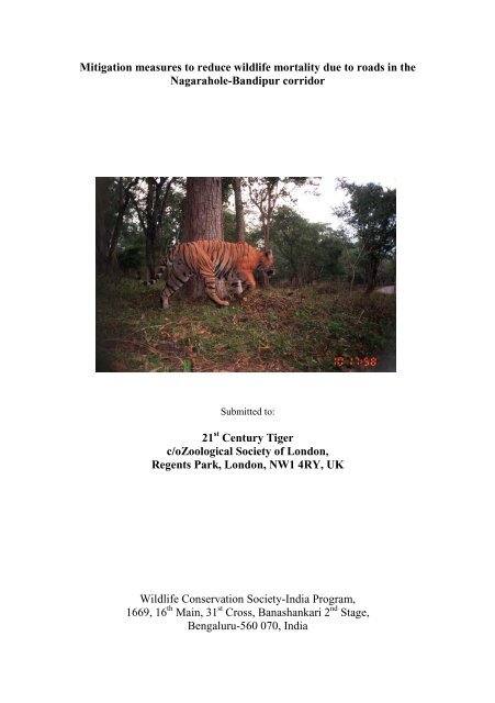
<strong>Tiger</strong>s used highway edges mostly when the traffic was non-existent during night time –<br />
©Sanjay Gubbi/<strong>WCS</strong>-India.<br />
30
Leopards showed similar patterns of highway edge avoidance as tigers - ©Sanjay Gubbi/<strong>WCS</strong>-<br />
India<br />
31
Capture rates of elephants and gaurs decreased in the highway segment where traffic density and<br />
human interference was higher - ©Sanjay Gubbi/<strong>WCS</strong>-India<br />
32
Sambar and chital were perhaps attracted to highway edges due to the higher availability of grass<br />
due to vegetation clearance carried out - ©Sanjay Gubbi/<strong>WCS</strong>-India<br />
33
Highest capture rates of domestic dog and cattle were seen in highway edges with highway<br />
human habitation/farmland interface - ©Sanjay Gubbi/<strong>WCS</strong>-India<br />
34
A tiger crosses Segment 1 of the Mysore-Mananthavadi Highway which is now closed to<br />
vehicular traffic due to the efforts of the Principal Investigator of this project - © Mahesh<br />
Mudaliyar<br />
The closed part of the Mysore-Mananthavadi Highway (segment 1) has allowed large carnivores<br />
to use the highway edges even during day time - ©H.C.Poornesha/<strong>WCS</strong>-India<br />
35
Camera trap results of the study showed higher usage of the Mysore-Mananthavadi Highway in<br />
closed part of the road (segment 1) by elephants during day time - ©Sanjay Gubbi/<strong>WCS</strong>-India<br />
A sub-adult tusker crosses the closed part of the Mysore-Mananthavadi Highway during day<br />
time - ©Vikram Nanjappa<br />
36
Young animals can be particularly susceptible to road kills due to speeding vehicles - ©Sanjay<br />
Gubbi/<strong>WCS</strong>-India<br />
37
It is important to install speed calming measures in curves, slopes and ridges - ©Vikram<br />
Nanjappa<br />
38


