Draft Town Belt Management Plan - Wellington City Council
Draft Town Belt Management Plan - Wellington City Council Draft Town Belt Management Plan - Wellington City Council
Table 9: Town Belt additions and boundary rationalisation – Mt Victoria sector Site name Legal description and area Lookout Road Pt Lots 76,77 DP 1301 open space Pt Lots 1 DP 88011 lands Pt Lots 1 DP 89011 Pt Lots 1 DP 85743 Pt Lot 1 DP 8574 Pt Lot DP 17217 Pt Lots 1 & 2 DP 17217 P t Lot 1 DP 23142 Pt Lot 1 DP 89011. Mt Victoria Lookout land Mt Victoria Radio Networks site 150 Alexandra Road The land is held in two parcels and described as: Lot 1 DP 6438, subject to s. 106 Res. & O.L.D. & P.B. Emp. Act 1922, vested in the Council in trust for road purposes, comprising 0.1555ha. Part of Mt Victoria and part of the land described in the 7 th Schedule to the Wellington Corporation and Harbour Board Streets and Lands Act 1892, CT 716/19. Held as Pleasure Ground and vested in the Council, pursuant to the Public Works Act 1928, Proclamation 5579, NZ Gazette 1956 page 917, comprising 1.8678ha. Description, location, current use Adjacent to, along the eastern side of, existing Town Belt and the Pleasure Ground land (at the Mt Victoria summit) is an area of Council owned land that is zoned open space B. This land contains, the Centennial memorial and around to the transmitter mast linking into Alexandra Road. Lookout Road was legally surveyed and gazetted in 2000. The area primarily consists of mown grass. It also has an outlook shelter and a water supply reservoir. The land described as the Mt Victoria Lookout includes the majority of the ring road, the Byrd Memorial, car parks and lookout platform on the top of Mt Victoria. This square-shaped land parcel was originally used as a signal station by the Harbour Board and subsequently vested in Wellington City Council for road and Pleasure Ground purposes. The Mt Victoria Lookout was original Town Belt land, but was allocated for public purposes or public utility before 1873. Following its use as a signal station by the Harbour Board, it was then taken for a pleasure ground and roading purposes and vested in Wellington City Council (CT 716/19). This land is located on the east side of Lookout Road along the Mt Victoria ridge, between the Mt Victoria Lookout and Centennial Memorial. This land is owned/administered by Radio Networks and the site used for telecommunications. Lot 1 DP11417 This is a Council-owned section next to Centennial Memorial land and located on the corner of Alexandra Road and Lookout Road. Previous policy Discussion, criteria assessment The land is identified in the These lands are contiguous TBMP 1995 as a potential with the Town Belt. These addition to the Town Belt. (Mt sections of land are visually Victoria Summit – the part of the Mount Victoria centennial memorial and area Lookout and ridgeline around the transmitter mast, as landscape which forms a per 11b, Figure 4 TBMP, pg. 17). strong focal point from the Central City. The Town Belt Management Plan (TBMP) 1995 states: The Council shall initiate action to reinstate the land currently held as ‘Pleasure Ground’ to its former Town Belt status and at the same time, shall initiate action to legalise the road looping the summit. (part 2, page 38) The lands were never Original Town Belt, nor included in the 1873 Deed, however it is zoned Open Space B. The site borders existing Town Belt and is a significant landscape focal point within the Town Belt and the city. Since the signal station closed, the land has been managed effectively and perceived as part of the Town Belt. It has significant historical and cultural meaning and memory associated with it – both European and Māori. This land adjoins Centennial Memorial (also proposed to become Town Belt). This section of land adds local landscape value to the Lookout Road experience. Recommendation Land covered by this TBMP It is recommended to add Yes these lands to the Town Belt. The Council should initiate action to reinstate the land currently held as ‘Pleasure Ground’ to its former Town Belt status and at the same time, take action to legalise the road looping the summit. This will involve appropriate survey work, gazetting the road, and inclusions to and exclusions from the Town Belt. If the ownership and/or use of this site changes then the Council will assess this site for possible addition to Town Belt. This land should be added to the Town Belt. Draft Town Belt Management Plan October 2012 169 Yes No Yes
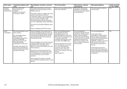
Site name Legal description and area Oriental Lots 2 & 3 DP 10507 Parade to Part CT 427/150 Palliser Road 3.7365ha Subject to the Deed of Conveyance 144970. Point Jerningham 170 The area discussed is in two parts, namely: the existing Recreation Reserve at Point Jerningham, being all the land in CT 22B/899, described as Section 167 Evans Bay District, comprising 0.7147ha, and the legal road, which is the green strip of land that lies between Carlton Gore Road and Oriental Parade. Description, location, current use This land is located between Oriental Parade, The Crescent and just south of Wilkinson Street. This land is subject to a right to the trusts and provisions set out in Deed of Conveyance 144970. Lot 3 was acquired as part of a land exchange in 1925. Lot 2 was conveyed to Council in 1883. This land is held as pleasure ground for the City of Wellington and its inhabitants. The start of the Southern Walkway starts here. There is a playground at The Crescent. Point Jerningham is the coastal area of land and escarpment that lies at the very eastern end of Oriental Parade, heading around to Evans Bay Parade. It can be accessed from Carlton Gore Road and Oriental Bay Parade. Point Jerningham is Council-owned land with Open Space B zoning. There is a building on part of the Recreation Reserve, now leased for drama, arts, and dance purposes. The land is also the firing base for the Defence Forces ceremonial salute, with two buildings and a concrete pad. It is used several times a year for these purposes. The escarpment is mainly covered by gorse with some emergent native or exotic species. Previous policy Discussion, criteria assessment This land was included as Town This land is a prominent Belt in the 1995 Plan. backdrop to Oriental Bay. Lot 2 was part of the original Town Belt (1841). The Town Belt Management Plan identifies the Point Jerningham reserve as a potential addition to the Town Belt network, management area 11, because of its visual continuity with this part of the Town Belt. The TBMP states: Undeveloped land at the tip of Point Jerningham can be seen as a small but significant extension of the Town Belt, linking the Town Belt open space to the harbour in this key location. (part 2, page 37) Draft Town Belt Management Plan October 2012 Point Jerningham is prominent visually from the central city. The Recreation Reserve and escarpment extends the green backdrop to the central city by visually linking the existing Town Belt with the harbour. The site is a natural extension to the Town Belt. Recommendation Land covered by this TBMP This land should be added to Yes the Town Belt. It is recommended that: a) the land at Point Jerningham, with Recreation Reserve status, described as Section 167 Evans Bay District, being all the land in CT 22B/899, is added to the Town Belt, because of its visual prominence and location in the city b) the longer term goal to protect the strip of open space land running between Oriental Parade and Carlton Gore Road be agreed to. Yes
- Page 121 and 122: Sector 5 - Macalister Park Landscap
- Page 123 and 124: Table 5: Town Belt additions, remov
- Page 125 and 126: 8.6 Sector 6 Golf Course/Mt Albert
- Page 127 and 128: 8.6.3 Landscape and ecological mana
- Page 129 and 130: Newtown Park in the 1890s (S C Smit
- Page 131 and 132: Table 6: Town Belt additions, remov
- Page 133 and 134: Baffin Gr Manitoba Pl Quebec St Map
- Page 135 and 136: Sector 6 - Golf Course / Mt Albert
- Page 137 and 138: Sector 6 - Golf Course / Mt Albert
- Page 139 and 140: 8.7 Sector 7 Newtown/Crawford Road
- Page 141 and 142: conditions agreed with the Crown. P
- Page 143 and 144: 140 . • the extent of building mo
- Page 145 and 146: Hanson St Tasman St Adelaide Rd Sto
- Page 147 and 148: Continuous green backdrop to the in
- Page 149 and 150: Table 7: Town Belt additions, remov
- Page 151 and 152: Site name Legal description and are
- Page 153 and 154: The sector is a highly visible ‘g
- Page 155 and 156: • Netball Wellington Centre admin
- Page 157 and 158: College St Te Aro Cambridge Tce Ell
- Page 159 and 160: Sector 8 - Hataitai Park Landscape
- Page 161 and 162: Table 8: Town Belt additions and bo
- Page 163 and 164: Town Belt between Mount Victoria an
- Page 165 and 166: 162 . • Mt Victoria lookout land
- Page 167 and 168: 8.9.4 Recreation Mt Victoria is mai
- Page 169 and 170: Herd St Roxburgh St Caroline St Bro
- Page 171: Sector 9 - Mt Victoria Management a
- Page 175 and 176: 9.2.6. Manage and maintain discreti
- Page 177 and 178: 174 • lease • licence • permi
- Page 179 and 180: 9.5.2 Signs 176 a. No signs or hoar
- Page 181 and 182: 178 (i) no practicable alternative
- Page 183 and 184: 180 Encroachments into the Town Bel
- Page 185 and 186: 182 encroachments, botanical enhanc
- Page 187 and 188: Appendix 1 Town Belt and Basin Rese
- Page 189 and 190: thereby granted which may be reason
- Page 191 and 192: Appendix 2 Land Schedules Land cove
- Page 193 and 194: Land protected under the 1873 Town
- Page 195 and 196: Name & Location Area Comprised in D
- Page 197 and 198: left to lie fallow. The garden area
- Page 199 and 200: Moera: Moe-ra (Moe-i-ra 54 or Moe-i
- Page 201 and 202: Waitangi Tribunal, Te Whanganui ā
- Page 203 and 204: iii. Best, E, Journal of the Polyne
- Page 205 and 206: 202 Draft Town Belt Management Plan
- Page 207 and 208: 204 Draft Town Belt Management Plan
- Page 209 and 210: Appendix 4 Town Belt historical out
- Page 211 and 212: 208 Figure 1: Plan of the town of W
- Page 213 and 214: aesthetic possibilities of the “r
- Page 215 and 216: uilding leases grew, prompting the
- Page 217 and 218: 214 The Wellington Zoological Garde
- Page 219 and 220: The plantation years Public agitati
- Page 221 and 222: The new balance - indigenous and ex
Site name Legal description and<br />
area<br />
Oriental Lots 2 & 3 DP 10507<br />
Parade to Part CT 427/150<br />
Palliser Road 3.7365ha<br />
Subject to the Deed of<br />
Conveyance 144970.<br />
Point<br />
Jerningham<br />
170<br />
The area discussed is in two<br />
parts, namely:<br />
the existing Recreation<br />
Reserve at Point<br />
Jerningham, being all the<br />
land in CT 22B/899,<br />
described as Section 167<br />
Evans Bay District,<br />
comprising 0.7147ha, and<br />
the legal road, which is the<br />
green strip of land that lies<br />
between Carlton Gore Road<br />
and Oriental Parade.<br />
Description, location, current<br />
use<br />
This land is located between Oriental<br />
Parade, The Crescent and just south of<br />
Wilkinson Street.<br />
This land is subject to a right to the trusts<br />
and provisions set out in Deed of<br />
Conveyance 144970. Lot 3 was acquired<br />
as part of a land exchange in 1925. Lot 2<br />
was conveyed to <strong>Council</strong> in 1883.<br />
This land is held as pleasure ground for<br />
the <strong>City</strong> of <strong>Wellington</strong> and its inhabitants.<br />
The start of the Southern Walkway starts<br />
here.<br />
There is a playground at The Crescent.<br />
Point Jerningham is the coastal area of<br />
land and escarpment that lies at the very<br />
eastern end of Oriental Parade, heading<br />
around to Evans Bay Parade. It can be<br />
accessed from Carlton Gore Road and<br />
Oriental Bay Parade.<br />
Point Jerningham is <strong>Council</strong>-owned land<br />
with Open Space B zoning. There is a<br />
building on part of the Recreation<br />
Reserve, now leased for drama, arts, and<br />
dance purposes.<br />
The land is also the firing base for the<br />
Defence Forces ceremonial salute, with<br />
two buildings and a concrete pad. It is<br />
used several times a year for these<br />
purposes.<br />
The escarpment is mainly covered by<br />
gorse with some emergent native or exotic<br />
species.<br />
Previous policy Discussion, criteria<br />
assessment<br />
This land was included as <strong>Town</strong> This land is a prominent<br />
<strong>Belt</strong> in the 1995 <strong>Plan</strong>.<br />
backdrop to Oriental Bay.<br />
Lot 2 was part of the original<br />
<strong>Town</strong> <strong>Belt</strong> (1841).<br />
The <strong>Town</strong> <strong>Belt</strong> <strong>Management</strong><br />
<strong>Plan</strong> identifies the Point<br />
Jerningham reserve as a<br />
potential addition to the <strong>Town</strong><br />
<strong>Belt</strong> network, management area<br />
11, because of its visual<br />
continuity with this part of the<br />
<strong>Town</strong> <strong>Belt</strong>. The TBMP states:<br />
Undeveloped land at the tip of<br />
Point Jerningham can be seen<br />
as a small but significant<br />
extension of the <strong>Town</strong> <strong>Belt</strong>,<br />
linking the <strong>Town</strong> <strong>Belt</strong> open<br />
space to the harbour in this key<br />
location.<br />
(part 2, page 37)<br />
<strong>Draft</strong> <strong>Town</strong> <strong>Belt</strong> <strong>Management</strong> <strong>Plan</strong> October 2012<br />
Point Jerningham is<br />
prominent visually from the<br />
central city. The Recreation<br />
Reserve and escarpment<br />
extends the green backdrop<br />
to the central city by visually<br />
linking the existing <strong>Town</strong><br />
<strong>Belt</strong> with the harbour. The<br />
site is a natural extension to<br />
the <strong>Town</strong> <strong>Belt</strong>.<br />
Recommendation Land covered<br />
by this TBMP<br />
This land should be added to Yes<br />
the <strong>Town</strong> <strong>Belt</strong>.<br />
It is recommended that:<br />
a) the land at Point<br />
Jerningham, with Recreation<br />
Reserve status, described as<br />
Section 167 Evans Bay District,<br />
being all the land in CT<br />
22B/899, is added to the <strong>Town</strong><br />
<strong>Belt</strong>, because of its visual<br />
prominence and location in<br />
the city<br />
b) the longer term goal to<br />
protect the strip of open space<br />
land running between Oriental<br />
Parade and Carlton Gore Road<br />
be agreed to.<br />
Yes


