structural geology, propagation mechanics and - Stanford School of ...
structural geology, propagation mechanics and - Stanford School of ...
structural geology, propagation mechanics and - Stanford School of ...

You also want an ePaper? Increase the reach of your titles
YUMPU automatically turns print PDFs into web optimized ePapers that Google loves.
anticipated sustainable pumping rate based on the results <strong>of</strong> simple slug tests <strong>and</strong> the<br />
assumption <strong>of</strong> homogeneous, isotropic permeability. Given any <strong>of</strong> the CB scenarios<br />
presented in Figures 7.12, 7.13 <strong>and</strong> 7.14, this approach would lead to misplaced wells,<br />
both in terms <strong>of</strong> their location relative to the effective contaminant transport direction <strong>and</strong><br />
the spacing needed for complete capture given elliptical drawdown patterns (Matthai et<br />
al., 1998). Failure to recognize the transport-distorting effects <strong>of</strong> CBs would also<br />
complicate efforts to locate the unknown source <strong>of</strong> a contaminant plume, <strong>and</strong>/or identify<br />
its extent based on limited well data.<br />
6. General discussion<br />
While the model simulation scenarios presented above in no way constitute a<br />
complete treatment <strong>of</strong> the flow <strong>and</strong> transport effects <strong>of</strong> CBs in the Aztec s<strong>and</strong>stone, the<br />
results do illustrate a clear potential for substantial impacts. Given the broad practical<br />
implications <strong>of</strong> these findings, a few key interpretations <strong>and</strong> assumptions underlying this<br />
work warrant further comment.<br />
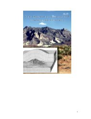
Firstly, as acknowledged in the section on mapping, limitations <strong>of</strong> outcrop exposure,<br />
image resolution <strong>and</strong> map scale prevent the final CB map (Figure 7.3) from capturing the<br />
full abundance <strong>and</strong> detail <strong>of</strong> the b<strong>and</strong> array present in the field. The map does, however,<br />
accurately represent the relative abundance, distribution, orientation <strong>and</strong> connectivity <strong>of</strong><br />
the exposed pattern <strong>of</strong> oldest CBs that dominates the area <strong>and</strong>, as such, is adequate to the<br />
purpose <strong>of</strong> modeling flow <strong>and</strong> transport effects at relatively coarse scales <strong>of</strong> practical<br />
interest. In fact, ins<strong>of</strong>ar as the true abundance, distribution <strong>and</strong> connectivity <strong>of</strong> the b<strong>and</strong>s<br />
are under-represented in the map, the substantial flow <strong>and</strong> transport effects realized here<br />
can reasonably be considered as conservative, low-end estimates.<br />
Also, our 2-D approach to an undeniably 3-D problem is dictated by the nature <strong>of</strong> the<br />
outcrop exposure, which presents a roughly horizontal slice through the CB array to<br />
reveal the detailed pattern as mapped. Given accurate 3-D data <strong>and</strong> sufficient computing<br />
power, the full spatial effects <strong>of</strong> the entire CB array could be modeled. Nonetheless,<br />
abundant field observations throughout the upper 600 m <strong>of</strong> the Aztec s<strong>and</strong>stone,<br />
particularly in areas <strong>of</strong> topographic relief, attest to the vertical persistence <strong>of</strong> the overall<br />
CB array. We suggest therefore that, to a reasonable first approximation, the<br />
anastomosing pattern <strong>of</strong> b<strong>and</strong>s in Figure 7.3 can be assumed to extend hundreds <strong>of</strong> meters<br />
196