Chart your course with GPS to navigate with confidence. - Garmin
Chart your course with GPS to navigate with confidence. - Garmin Chart your course with GPS to navigate with confidence. - Garmin
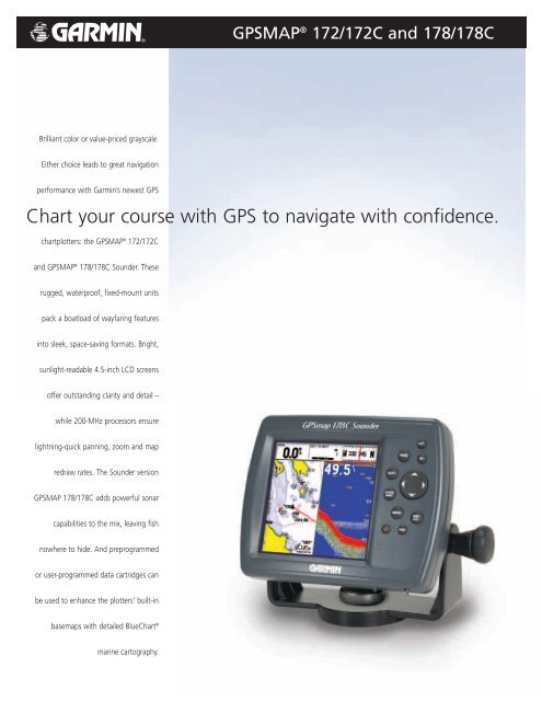
Brilliant color or value-priced grayscale. Either choice leads to great navigation performance with Garmin’s newest GPS chartplotters: the GPSMAP ® 172/172C and GPSMAP ® 178/178C Sounder. These rugged, waterproof, fixed-mount units pack a boatload of wayfaring features into sleek, space-saving formats. Bright, sunlight-readable 4.5-inch LCD screens offer outstanding clarity and detail – while 200-MHz processors ensure lightning-quick panning, zoom and map redraw rates. The Sounder version GPSMAP 178/178C adds powerful sonar capabilities to the mix, leaving fish nowhere to hide. And preprogrammed or user-programmed data cartridges can be used to enhance the plotters’ built-in basemaps with detailed BlueChart ® marine cartography. GPSMAP ® 172/172C and 178/178C Chart your course with GPS to navigate with confidence.
Brilliant color or value-priced grayscale.<br />
Either choice leads <strong>to</strong> great navigation<br />
performance <strong>with</strong> <strong>Garmin</strong>’s newest <strong>GPS</strong><br />
chartplotters: the <strong>GPS</strong>MAP ® 172/172C<br />
and <strong>GPS</strong>MAP ® 178/178C Sounder. These<br />
rugged, waterproof, fixed-mount units<br />
pack a boatload of wayfaring features<br />
in<strong>to</strong> sleek, space-saving formats. Bright,<br />
sunlight-readable 4.5-inch LCD screens<br />
offer outstanding clarity and detail –<br />
while 200-MHz processors ensure<br />
lightning-quick panning, zoom and map<br />
redraw rates. The Sounder version<br />
<strong>GPS</strong>MAP 178/178C adds powerful sonar<br />
capabilities <strong>to</strong> the mix, leaving fish<br />
nowhere <strong>to</strong> hide. And preprogrammed<br />
or user-programmed data cartridges can<br />
be used <strong>to</strong> enhance the plotters’ built-in<br />
basemaps <strong>with</strong> detailed Blue<strong>Chart</strong> ®<br />
marine car<strong>to</strong>graphy.<br />
<strong>GPS</strong>MAP ® 172/172C and 178/178C<br />
<strong>Chart</strong> <strong>your</strong> <strong>course</strong> <strong>with</strong> <strong>GPS</strong> <strong>to</strong> <strong>navigate</strong> <strong>with</strong> <strong>confidence</strong>.
Navigation features<br />
Waypoints/icons: 3,000 waypoints <strong>with</strong> name, symbol,<br />
depth and water symbols, 10 proximity<br />
Routes: 50 reversible routes <strong>with</strong> up <strong>to</strong> 50 points<br />
each, plus MOB and TracBack ® modes<br />
Tracks: 10,000 point au<strong>to</strong>matic track log; 15<br />
saved tracks (up <strong>to</strong> 700 track points each)<br />
let you retrace <strong>your</strong> path in both directions<br />
Trip computer: Trip odometer, s<strong>to</strong>pped time, moving<br />
average, moving time, <strong>to</strong>tal average,<br />
<strong>to</strong>tal time, maximum speed, odometer<br />
Alarms: Anchor drag, arrival, off-<strong>course</strong>,<br />
proximity waypoint and clock<br />
Tables: Built-in celestial tables for sun and moon<br />
by date and position<br />
Tides: Tide data (U.S.A. only)<br />
Map datums: More than 106 including user datum<br />
Position format: Lat/Lon, UTM/UPS, Maidenhead, MGRS,<br />
Loran TDs and other grids<br />
DSC Support: Yes<br />
<strong>GPS</strong> performance<br />
Receiver: WAAS enabled, 12 parallel channel <strong>GPS</strong><br />
receiver continuously tracks and uses up<br />
<strong>to</strong> 12 satellites <strong>to</strong> compute and update<br />
<strong>your</strong> position<br />
Acquisition times:<br />
Warm: Approximately 15 seconds<br />
Cold: Approximately 45 seconds<br />
Au<strong>to</strong>Locate : Approximately 5 minutes<br />
Update rate: 1/second, continuous<br />
<strong>GPS</strong> accuracy:<br />
Position: < 15 meters,(49 feet) 95% typical<br />
Velocity: 0.05 meter/sec steady state<br />
Interfaces: NMEA 0183 (2 inputs), RTCM 104 D<strong>GPS</strong><br />
corrections and outputs<br />
Antenna: Choice of Internal or External QuadHelix<br />
(GA 29 remote marine mount<br />
<strong>with</strong> 30’ cable)<br />
Plotter/moving map features<br />
Basemap: Built-in Worldwide Marine basemap <strong>to</strong><br />
32 nm <strong>with</strong> coastlines, rivers, lakes,<br />
political boundaries, tide data for the U.S.,<br />
cities, interstates, U.S. state highways and<br />
major thoroughfares<br />
Uploadable maps: Accepts preprogrammed or<br />
user-programmed <strong>Garmin</strong> data cards<br />
containing optional MapSource<br />
car<strong>to</strong>graphy<br />
Plotting scales: 20 feet <strong>to</strong> 800 nm <strong>with</strong> dedicated<br />
push-but<strong>to</strong>n zoom control<br />
<strong>GPS</strong>MAP ® 172/172C and 178/178C<br />
Power<br />
Source: 10-35 vDC<br />
compatible<br />
Usage: <strong>GPS</strong>MAP 172C/172 = 6 watts<br />
<strong>GPS</strong>MAP 178C/178 sounder = 14 watts<br />
Physical<br />
Size: 4.9”H x 6.3”W x 2.8”D<br />
(122.5 x 157.5 x 71 mm)<br />
Weight: 172C/172 = 1 lb. 1 oz.<br />
178C/178 = 1 lb. 3.5 oz.<br />
Display: 3.2" W x 3.2" H, 320 x 320 pixels<br />
<strong>with</strong> adjustable CCFL backlighting<br />
172C/178C = 256 color CSTN<br />
172/178 = 10-level FSTN<br />
Case: Fully gasketed, high impact plastic alloy,<br />
waterproof <strong>to</strong> IEC 60529 IPX7 standards<br />
Temperature range: 5ºF <strong>to</strong> 131ºF (-15ºC <strong>to</strong> 50ºC)<br />
User data s<strong>to</strong>rage: Internal backup of user settings,<br />
no memory battery required<br />
Accessories<br />
Standard: <strong>Chart</strong>plotting receiver<br />
Remote antenna <strong>with</strong> 30’ cable<br />
or internal antenna<br />
Power/data cable<br />
User’s manual<br />
Single-knob tilt & swivel bracket<br />
Quick start guide<br />
Unit cover<br />
Various transducers (178/178C only)<br />
Optional: Compatible <strong>with</strong> most <strong>Garmin</strong><br />
MapSource ® products, including<br />
Recreational Lakes <strong>with</strong> Fishing Hot<br />
Spots ® , Blue<strong>Chart</strong> ® , Recreational Lakes<br />
<strong>with</strong> Fishing Hot Spots ® , Topo. (<strong>Garmin</strong><br />
data cartridges required)<br />
<strong>GPS</strong>MAP 172/172C chartplotter is<br />
compatible <strong>with</strong> optional GSD 20 remote<br />
module <strong>to</strong> add full Sounder capabilities<br />
Depth Sounder features (<strong>GPS</strong>MAP 178/178C Sounder only)<br />
Frequency: 50/200 kHz or 200 kHz<br />
Transmit power: 500 watts (RMS), 4000 watts (peak-<strong>to</strong>peak)<br />
w/ dual frequency transducer<br />
400 watts (RMS), 3200 watts (peak-<strong>to</strong>peak)<br />
w/ single frequency transducer<br />
Performance features: Depth Control Gain (DCG ® ) for detailed<br />
bot<strong>to</strong>m and structure views; adjustable<br />
range, gain and zoom; 3-level fish ID;<br />
graphic whiteline provides clear image of<br />
bot<strong>to</strong>m hardness and structure; See-Thru ®<br />
technology separates fish returns from<br />
thermoclines and structure<br />
Alarms: Shallow water, fish by size, anchor drift,<br />
timer, temperature, and low battery<br />
voltage<br />
Transducers: Choice of single or dual frequency<br />
transom-mount transducers. Also<br />
available <strong>with</strong>out transducer<br />
1104 M01-10157-00<br />
Map Page<br />
Data cartridges provide optional MapSource<br />
data for enhanced map detail<br />
Big Numbers Option<br />
Enlarge size of data fields <strong>to</strong> make them<br />
readable from a distance<br />
Navigation page<br />
Shows distance, speed and direction <strong>to</strong><br />
waypoint, helping you stay on <strong>course</strong><br />
©2004 <strong>Garmin</strong> Ltd. or its subsidiaries<br />
<strong>Garmin</strong> International, Inc.<br />
1200 East 151st Street<br />
Olathe, Kansas 66062, U.S.A.<br />
913/397.8200 fax 913/397.8282<br />
<strong>Garmin</strong> (Europe) Ltd.<br />
Unit 5, The Quadrangle<br />
Abbey Park Industrial Estate<br />
Romsey, SO51 9DL, U.K.<br />
44/1794.519944 fax 44/1794.519222<br />
<strong>Garmin</strong> Corporation<br />
No. 68, Jangshu 2nd Rd.<br />
Shijr, Taipei County, Taiwan<br />
886/2.2642.9199 fax 886/2.2642.9099<br />
www.garmin.com<br />
Specifications are preliminary and subject <strong>to</strong> change<br />
<strong>with</strong>out notice.


