GNC 250XL/GPS 150XL - Garmin
GNC 250XL/GPS 150XL - Garmin
GNC 250XL/GPS 150XL - Garmin

You also want an ePaper? Increase the reach of your titles
YUMPU automatically turns print PDFs into web optimized ePapers that Google loves.
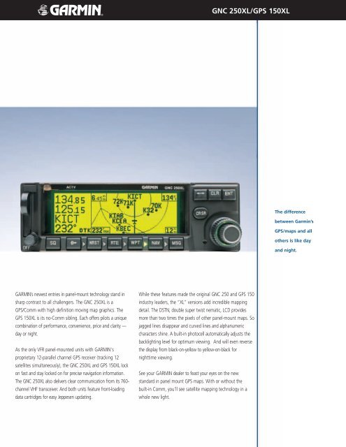
GARMIN’s newest entries in panel-mount technology stand in<br />
sharp contrast to all challengers. The <strong>GNC</strong> <strong>250XL</strong> is a<br />
<strong>GPS</strong>/Comm with high definition moving map graphics. The<br />
<strong>GPS</strong> <strong>150XL</strong> is its no-Comm sibling. Each offers pilots a unique<br />
combination of performance, convenience, price and clarity —<br />
day or night.<br />
As the only VFR panel-mounted units with GARMIN’s<br />
proprietary 12-parallel channel <strong>GPS</strong> receiver (tracking 12<br />
satellites simultaneously), the <strong>GNC</strong> <strong>250XL</strong> and <strong>GPS</strong> <strong>150XL</strong> lock<br />
on fast and stay locked on for precise navigation information.<br />
The <strong>GNC</strong> <strong>250XL</strong> also delivers clear communication from its 760channel<br />
VHF transceiver. And both units feature front-loading<br />
data cartridges for easy Jeppesen updating.<br />
<strong>GNC</strong> <strong>250XL</strong>/<strong>GPS</strong> <strong>150XL</strong><br />
While these features made the original <strong>GNC</strong> 250 and <strong>GPS</strong> 150<br />
industry leaders, the “XL” versions add incredible mapping<br />
detail. The DSTN, double super twist nematic, LCD provides<br />
more than two times the pixels of other panel-mount maps. So<br />
jagged lines disappear and curved lines and alphanumeric<br />
characters shine. A built-in photocell automatically adjusts the<br />
backlighting level for optimum viewing. And will even reverse<br />
the display from black-on-yellow to yellow-on-black for<br />
nighttime viewing.<br />
See your GARMIN dealer to feast your eyes on the new<br />
standard in panel mount <strong>GPS</strong> maps. With or without the<br />
built-in Comm, you’ll see satellite mapping technology in a<br />
whole new light.<br />
The difference<br />
between <strong>Garmin</strong>’s<br />
<strong>GPS</strong>/maps and all<br />
others is like day<br />
and night.
<strong>GNC</strong> <strong>250XL</strong>/<strong>GPS</strong> <strong>150XL</strong> specifications<br />
Jeppesen Database<br />
Coverage: Americas, International or Worldwide<br />
Airports: Identifier, city/state, country, facility name,<br />
lat/long, elevation, fuel service, control,<br />
approach information<br />
VORs: Identifier, city/state, country, facility name,<br />
lat/long, freq., co-located DME (or TACAN),<br />
magnetic variation, weather broadcast<br />
indication<br />
NDBs: Identifier, city/state, country, facility name,<br />
lat/long, freq., weather broadcast indication<br />
Intersections: Identifier, country, lat/long, nearest VOR<br />
Comm Freq.: Approach, arrival, control area, departure,<br />
Class B, Class C, CTA, TMA,<br />
TRSA with sector, altitude and text usage; also<br />
ATIS, clearance delivery, tower, ground,<br />
unicom, pre-taxi<br />
Runways: Designation, length, surface, lighting,<br />
ILS/localizer freq. and ID, pilot controlled<br />
lighting freq.<br />
FSS/ARTCC: Identifier, reference VOR (FSS only), freq.,<br />
usage<br />
MSA: Minimum safe altitude along and in proximity<br />
to user-defined flight plan<br />
SUA: US Class B & C with sectors, Int. CTA, TMA &<br />
TRSA with sectors, all SUAs, including MOAs,<br />
prohibited and restricted w/ controlling agency<br />
& airport<br />
Safety<br />
Emergency Search: 9 nearest airports, VORs, NDBs, intersections,<br />
or user waypoints; 2 nearest FSS with<br />
frequencies; 2 nearest ARTCC frequencies<br />
Power Backup: Optional NiCad battery pack automatically<br />
powers unit in case of electric power failure<br />
Alarms: Arrival, proximity, timers, SUAs less than 10<br />
minutes, 2nm and inside SUA<br />
User Customization<br />
Waypoints: 1000 user-defined<br />
Flight Plans: 20 reversible routes of up to 31 waypoints<br />
each<br />
Comments: Storage for comments on up to 250<br />
waypoints<br />
Checklists: 9 user checklists of up to 30 items each<br />
Messages: 9 scheduled user messages<br />
Physical specifications<br />
Size:<br />
Unit: 6.25 x 5.64 x 2 inches, 159 x 143 x 51 mm<br />
Rack w/connectors: 6.32 x 6.79 x 2 inches, 161 x 172 x 51 mm<br />
Weight:<br />
Unit: 2.55 lbs.* (<strong>150XL</strong> is 1.70 lbs.), 1.16 kg* (.77 kg)<br />
Rack w/connectors: .83 lbs., 0.38 kg<br />
Display:<br />
80 x 240 double super twist pneumatic with six<br />
times the contrast of typical DSTN displays.<br />
Automatic contrast adjustment with reverse<br />
mode for exceptional readability in direct sunlight<br />
or at night.<br />
Source:<br />
10-15 VDC* (<strong>150XL</strong> is 10-33VDC), optional<br />
remote rechargeable battery, 115-230 VAC<br />
with optional AC adapter for <strong>GPS</strong> simulator<br />
operation<br />
<strong>Garmin</strong> International, Inc.<br />
1200 East 151st Street, Olathe, KS 66062<br />
p: 913.397.8200 f: 913.397.8282<br />
<strong>Garmin</strong> (Europe) Ltd. Unit 5, The Quadrangle, Abbey Park Industrial Estate,<br />
Romsey, SO51 9DL, U.K. 44.1794.519944 fax 44.1794.519222<br />
<strong>Garmin</strong> Corporation, No. 68, Jangshu 2nd Road, Shijr, Taipei County,<br />
Taiwan 886.2.2642.9199 fax 886.2.2642.9099<br />
Battery Life: Up to 2 hours with screen time out enabled<br />
Data Storage: Internal battery retains stored data up to 5 years<br />
Environmental<br />
Temperature:<br />
Operating: -20ºC to +55ºC (-4ºF to +131ºF)<br />
Storage: -55ºC to +85ºC (-67ºF to +185ºF)<br />
Humidity: 95% non-condensing<br />
Performance<br />
Certification: TSO C37d Class 4 (VHF Transmitter)*<br />
TSO C38d Class C (VHF Receiver)*<br />
AC 20-138 (VFR) (<strong>GPS</strong> Receiver)<br />
VHF Transceiver*: 760-channel, aviation band 118-136.975 MHz<br />
5 watt minimum transmitter power<br />
<strong>GPS</strong> Receiver: PhaseTrac12 TM , 12 parallel channel receiver,<br />
simultaneously tracks and uses up to 12<br />
satellites<br />
Acquisition Time: 15 seconds (warm), 45 seconds (cold)<br />
Update Rate: 1/second, continuous<br />
Accuracy:<br />
Position: 15 meters (49 feet) RMS**, 1-5 m w/ D<strong>GPS</strong><br />
corrections<br />
Velocity: 0.1 knot RMS steady state<br />
Dynamics:<br />
Velocity: 999 knots<br />
Acceleration: 6G<br />
Comm. Features*: Auto squelch control, standard headset output<br />
with sidetone and audio leveling, stuck mike<br />
transmission timeout, emergency channel<br />
select, ‘autotune’ frequency selection<br />
Navigation Features: Search and Rescue Operation (ladder search),<br />
pilot-defined course selection and waypoint<br />
hold, Closest Point of Approach, dep. & arr.<br />
frequencies<br />
Moving Map Features: 14 map scales from 0.5 to 300 nm, with<br />
nearby waypoints, navaids and sectorized<br />
airspace, runway, and navigation data<br />
displayed. Autozoom feature automatically<br />
keeps present position and destination on the<br />
map, with user-selectable track up, north up or<br />
DTK up display<br />
Planning Features: True Airspeed, Density Altitude, Winds Aloft,<br />
RAIM Availability, Sunrise/Sunset Calculations,<br />
Trip, Fuel and VNAV Planning<br />
Interfaces: ARINC 429, RS 232 – Plotting (NMEA 0183<br />
v.2.0), Aviation, PC Interface, Altitude<br />
Serializer, Fuel Sensor, Fuel/Air Data Computer<br />
Map Datums: 124 and 1 user-defined (Stored on NavData ® Card)<br />
Components<br />
Standard: <strong>GNC</strong> <strong>250XL</strong> or <strong>GPS</strong> <strong>150XL</strong><br />
NavData ® Card<br />
Aviation Installation Kit — <strong>GPS</strong> Antenna, Rack<br />
and Connectors<br />
3/32" Hex Wrench<br />
Pilot‘s Guide<br />
Quick Reference Card<br />
Database Subscription Packet<br />
Optional: Remote NiCad Battery/Charger Pack<br />
115/230 VAC Adapter<br />
Personal Computer Kit<br />
User Data Card<br />
28 to 14 VDC converter*<br />
*<strong>GNC</strong> <strong>250XL</strong> Only<br />
*Specifications subject to change without notice.<br />
*Jeppensen and NavData are trademarks of Jeppesen Sanderson<br />
**Subject to accuracy degradation to 100m 2DRMS under the Unites States<br />
Department of Defense imposed Selective Availability program.<br />
www.garmin.com © 2003 <strong>Garmin</strong> Ltd. or its subsidiaries 0903<br />
M01-10079-00