gpsmap 192c - Garmin
gpsmap 192c - Garmin
gpsmap 192c - Garmin

Create successful ePaper yourself
Turn your PDF publications into a flip-book with our unique Google optimized e-Paper software.
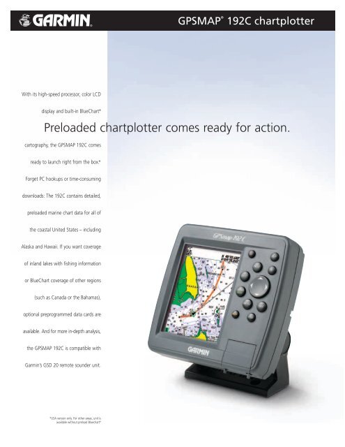
With its high-speed processor, color LCD<br />
display and built-in BlueChart ®<br />
Preloaded chartplotter comes ready for action.<br />
cartography, the GPSMAP 192C comes<br />
ready to launch right from the box.*<br />
Forget PC hookups or time-consuming<br />
downloads: The 192C contains detailed,<br />
preloaded marine chart data for all of<br />
the coastal United States – including<br />
Alaska and Hawaii. If you want coverage<br />
of inland lakes with fishing information<br />
or BlueChart coverage of other regions<br />
(such as Canada or the Bahamas),<br />
optional preprogrammed data cards are<br />
available. And for more in-depth analysis,<br />
the GPSMAP 192C is compatible with<br />
<strong>Garmin</strong>’s GSD 20 remote sounder unit.<br />
*USA version only. For other areas, unit is<br />
available without preload Bluechart ®<br />
GPSMAP ®<br />
192C chartplotter
Navigation features<br />
Waypoints/icons: 3000 with name, symbol and comments;<br />
support for proximity waypoints<br />
Routes: 50 reversible routes with up to 254 points<br />
each, plus MOB and TracBack ® modes<br />
Tracks: 2500 point automatic track log, 15 saved<br />
tracks; 500 points per saved track, lets<br />
you retrace your path in both directions<br />
Alarms: Anchor drag, arrival, off course,<br />
proximity waypoint, clock and low battery<br />
Tables: Built-in celestial tables with sun and<br />
moon rise, set and location. Tide tables<br />
for the U.S.<br />
Map datums: More than 100, plus user datum<br />
Position format: Lat/Lon, UTM/UPS, Loran TDs and other<br />
grids, including user grid<br />
Languages: 10<br />
GPS performance<br />
Receiver: WAAS enabled, 12 parallel channel GPS<br />
receiver continuously tracks and uses up<br />
to 12 satellites to compute and update<br />
your position<br />
Acquisition times:<br />
Warm: Approximately 15 seconds<br />
Cold: Approximately 45 seconds<br />
AutoLocate : Approximately 5 minutes<br />
Update rate: 1/second, continuous<br />
GPS accuracy:<br />
Position: < 15 meters, 95% typical*<br />
Velocity: 0.05 meter/sec steady state<br />
DGPS (USCG) accuracy:<br />
Position: 3-5 meters, 95% typical<br />
Velocity: 0.05 meter/sec steady state<br />
DGPS (WAAS) accuracy:<br />
Position: 3 meters, 95% typical<br />
Velocity: 0.05 meter/sec steady state<br />
Dynamics: 6g’s<br />
Interfaces: 2-RS232 with NMEA 0183, RTCM 104 DGPS<br />
data format and proprietary <strong>Garmin</strong><br />
Antenna:<br />
External: patch style, GA 29 with 30 ft. cable<br />
Internal: quad-helix<br />
Plotter/moving map features<br />
Detailed maps: Unit comes preprogrammed with detailed<br />
MapSource ® BlueChart ® marine<br />
cartography, covering all U.S. coastal<br />
waters – including Alaska and Hawaii<br />
Basemap: Built-in worldwide basemap to 32nm<br />
with coastlines, rivers, lakes, political<br />
boundaries, tide data for the U.S.,<br />
cities and interstates<br />
GPSMAP ®<br />
Power<br />
Source: 8-35v DC<br />
Usage: 4 watts max. at 13.8v DC<br />
Physical<br />
Size: 6.3" W x 6.2" H x 2.6" D<br />
Weight: 1.4 lbs. (.64 kg)<br />
Display: 5.0" diagonal (12.7 cm) 16-color TFT<br />
display with backlighting (234 x 320 pixels)<br />
Case: Fully gasketed, high impact plastic alloy,<br />
waterproof to IEC 60529 IPX7 standards<br />
Temp. range: 5ºF to 158ºF (-15ºC to 70ºC)<br />
Accessories<br />
Standard: GPSMAP 192C, external GPS antenna, unit,<br />
power/data cable, swivel/ball mount, GA<br />
29 antenna, unit cover, owner’s manual<br />
and quick reference guide<br />
GPSMAP 192C, internal GPS antenna,<br />
unit, power/data cable, swivel/ball<br />
mount, quad helix antenna, unit cover,<br />
owner’s manual and quick<br />
reference guide<br />
Optional: preprogrammed data cards with<br />
BlueChart marine cartography<br />
AC/PC adapter<br />
12-volt adapter cable<br />
bail mount antenna bracket<br />
USB data card programmer<br />
MapSource ® CDs:<br />
BlueChart ®<br />
Minnesota LakeMaster ®<br />
U.S. Recreational Lakes with<br />
Fishing Hot Spots ®<br />
REV0405 M01-10196-00<br />
192C chartplotter<br />
compatible<br />
The big numbers<br />
option makes<br />
data fields<br />
readable from<br />
a distance.<br />
The graphic<br />
pointer helps<br />
you stay on<br />
course to your<br />
destination.<br />
Tide charts<br />
display detailed<br />
tide data for<br />
the U.S.<br />
©2005 <strong>Garmin</strong> Ltd. or its subsidiaries<br />
<strong>Garmin</strong> International, Inc.<br />
1200 East 151st Street<br />
Olathe, Kansas 66062, U.S.A.<br />
913/397.8200 fax 913/397.8282<br />
<strong>Garmin</strong> (Europe) Ltd.<br />
Unit 5, The Quadrangle<br />
Abbey Park Industrial Estate<br />
Romsey, SO51 9DL, U.K.<br />
44/1794.519944 fax 44/1794.519222<br />
<strong>Garmin</strong> Corporation<br />
No. 68, Jangshu 2nd Rd.<br />
Shijr, Taipei County, Taiwan<br />
886/2.2642.9199 fax 886/2.2642.9099<br />
www.garmin.com<br />
Specifications are preliminary and subject to change<br />
without notice.<br />
* Subject to accuracy degradation to 100m<br />
2DRMS under the U.S. Department of Defense<br />
imposed Selective Availability Program.<br />
**Depth capacity is dependent on water salinity,<br />
bottom type, and other water conditions.