*GPSMAP 185 SpecSht.lyt - Garmin
*GPSMAP 185 SpecSht.lyt - Garmin
*GPSMAP 185 SpecSht.lyt - Garmin

Create successful ePaper yourself
Turn your PDF publications into a flip-book with our unique Google optimized e-Paper software.
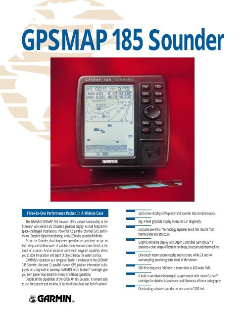
GPSMAP <strong>185</strong> Sounder<br />
Three-In-One Performance Packed In A Midsize Case Split screen displays GPS/plotter and sounder data simultaneously.<br />
The GARMIN GPSMAP <strong>185</strong> Sounder offers unique functionality to the<br />
fisherman who wants it all. It boasts a generous display. A small footprint for<br />
space-challenged installations. Powerful 12 parallel channel GPS performance.<br />
Detailed digital chartplotting. And a 200 KHz sounder/fishfinder.<br />
As for the Sounder, dual frequency operation lets you keep an eye on<br />
both deep and shallow water. A variable zoom window shows details at the<br />
touch of a button. And an exclusive underwater waypoint capability allows<br />
you to store the position and depth of objects below the water’s surface.<br />
GARMIN’s reputation as a navigation leader is evidenced in the GPSMAP<br />
<strong>185</strong> Sounder. Accurate 12 parallel channel GPS position information is displayed<br />
on a big built-in basemap. GARMIN micro G-chart TM cartridges give<br />
you even greater map details for inland or offshore operations.<br />
Despite all the capabilities of the GPSMAP <strong>185</strong> Sounder, it remains easy<br />
to use. Uncluttered and intuitive, it has the distinct look and feel of a winner.<br />
Big, 4-level grayscale display measures 5.5" diagonally.<br />
Exclusive See-Thru TM technology separates black fish returns from<br />
thermoclines and structure.<br />
Graphic whiteline display with Depth Controlled Gain (DCG)<br />
presents a clear image of bottom hardness, structure and thermoclines.<br />
One-touch instant zoom rescales entire screen, while 2X and 4X<br />
oversampling provides greater detail of the bottom.<br />
200 KHz frequency fishfinder is transmitted at 400 watts RMS.<br />
A built-in worldwide basemap is supplemented with micro G-chart TM<br />
cartridges for detailed inland water and Navionics offshore cartography.<br />
Outstanding saltwater sounder performance to 1200 feet.
0698<br />
GPSMAP <strong>185</strong> Sounder<br />
Navigation Features<br />
Waypoints:<br />
Total: 250 alphanumeric<br />
Nearest: 9 (automatic)<br />
Proximity: 9 (definable)<br />
Routes: 20 reversible routes with<br />
up to 30 waypoints each, plus<br />
MOB and TracBack TM modes<br />
Track Log: Approx. 2,000 points<br />
Map Datums: 106<br />
Coordinates: Lat/lon, UTM/UPS, plus<br />
7 grids, including Maidenhead<br />
Performance<br />
GPS Receiver: Differential-ready 12 parallel<br />
channel receiver tracks all<br />
satellites in view<br />
Depth Sounder:<br />
Frequency: 200 KHz<br />
Transmit Power: 400 watts (RMS)<br />
3200 watts (peak to peak)<br />
GPS Acquisition Times:<br />
Warm: Approx. 15 seconds<br />
Cold: Approx. 45 seconds<br />
AutoLocate TM : Approx. 5 minutes<br />
Update Rate: 1/second, continuous<br />
Accuracy:<br />
Position: 15 meters (49 feet) RMS*<br />
1-5 meters (3-15 feet) RMS<br />
with GARMIN GBR 21<br />
DGPS receiver (optional)<br />
Velocity: 0.1 knot RMS steady state<br />
Dynamics: 6g’s<br />
Interfaces: NMEA 0180, 0182, 0183 and<br />
RTCM 104 DGPS corrections<br />
Antenna: GA 28 Remote Marine Mount<br />
with 30' cable<br />
Plotter/Moving Map Features<br />
Database: Built-in basemap to 64 nm<br />
(32 nm U.S.) with coasts, rivers,<br />
lakes, political boundaries, plus<br />
major cities and highways<br />
Data Cartridges: Micro G-chart TM cartridges with<br />
inland water and Navionics<br />
offshore cartography for<br />
seamless, detailed mapping<br />
and worldwide coverage<br />
(optional)<br />
Plotting Scales: 1/8 to 4096 nm with dedicated<br />
push-button zoom control<br />
Power<br />
Source: 10-40 volts DC<br />
Usage: 15 watts (max)<br />
Depth Sounder Features<br />
Display Options: Auto bottom tracking, auto ranging,<br />
4 zoom levels, split screen feature,<br />
and 3-level fish ID<br />
Alarms: Fish and shallow/deep water<br />
Physical<br />
Size: 6.18"H x 6.30"W x 2.64"D<br />
(157mm x 160mm x 67mm)<br />
Weight: 28.8 oz. (.816 kg)<br />
Display: 5.5" diagonal (141mm)<br />
high-contrast, 4-level gray LCD<br />
with backlighting (160 x 240 pixels)<br />
Case: Fully gasketed, high-impact plastic alloy,<br />
waterproof to IEC 529-IPX-7<br />
Temp. Range: 5ºF to 158ºF (-15ºC to 70ºC)<br />
Accessories<br />
Standard: GPSMAP <strong>185</strong> Chartplotting Depth Sounder<br />
Standard Transom-Mount Transducer**<br />
Remote Antenna with 30' Cable<br />
Power/Data Cable<br />
Surface/Flush Mount Bracket with Knobs<br />
User’s Manual<br />
Quick Reference Guide<br />
Optional: PC Kit<br />
Micro G-chart TM Cartography Cartridges<br />
Transducers in a Wide Variety of<br />
Transom and Through-Hull Mounts<br />
Specifications are preliminary and subject to change without notice.<br />
* Subject to accuracy degradation to 100m 2DRMS under the United<br />
States Department of Defense imposed Selective Availability Program.<br />
** Also available without a transducer.<br />
GARMIN International<br />
1200 East 151st Street<br />
Olathe, Kansas 66062, U.S.A.<br />
913/397.8200 FAX 913/397.8282<br />
GARMIN (Europe) Ltd.<br />
Unit 5, The Quadrangle, Abbey Park Industrial Estate<br />
Romsey, SO51 9AQ, U.K.<br />
44/1794.519944 FAX 44/1794.519222<br />
GARMIN (Asia) Corporation<br />
3rd Floor, No. 1, Lane 45, Pao-Hsing Road<br />
Hsin Tien, Taipei, Taiwan<br />
886/2.2917.3773 FAX 886/2.2917.1758<br />
www.garmin.com<br />
© 1998 GARMIN Corporation<br />
GPSMAP <strong>185</strong> SOUNDER<br />
M01-10078-00