GDL 69/69A satellite data link receiver - Garmin
GDL 69/69A satellite data link receiver - Garmin GDL 69/69A satellite data link receiver - Garmin
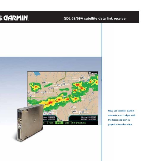
GDL 69/69A satellite data link receiver Now, via satellite, Garmin connects your cockpit with the latest and best in graphical weather data.
<strong>GDL</strong> <strong>69</strong>/<strong>69</strong>A <strong>satellite</strong> <strong>data</strong> <strong>link</strong> <strong>receiver</strong><br />
Now, via <strong>satellite</strong>, <strong>Garmin</strong><br />
connects your cockpit with<br />
the latest and best in<br />
graphical weather <strong>data</strong>.
A breakthrough in inflight weather <strong>data</strong> delivery, the remote<br />
<strong>GDL</strong> <strong>69</strong> <strong>satellite</strong> <strong>receiver</strong> teams with a variety of <strong>Garmin</strong><br />
navigation displays to bring reliable, continuous weather<br />
updates directly into the cockpit.<br />
Through a partnership with XM<br />
Satellite Radio and their XM WX Satellite Weather service, <strong>Garmin</strong><br />
now makes it possible for near<br />
real-time graphical weather <strong>data</strong><br />
to be accessed directly on the<br />
popular GNS 400 and 500 series<br />
navigators, the MX20 Multifunction<br />
display, and the fully<br />
integrated G1000 “glass<br />
cockpit” system,<br />
Using the <strong>GDL</strong> <strong>69</strong>, pilots<br />
who subscribe to the XM<br />
WX aviation service can have<br />
instant access to a wide array<br />
of North American weather<br />
reports and outputs, including*:<br />
• High-resolution<br />
NEXRAD<br />
weather <strong>data</strong>**<br />
• METARS (in<br />
textual or<br />
graphical form)*<br />
• TAFs<br />
• TFRs<br />
• Winds aloft<br />
• Echo tops<br />
• Precipitation<br />
type (at surface)<br />
• Lightning<br />
Physical<br />
Dimensions: 7.20” D x 6.15” W x 1.05” H<br />
Mounting: Mounting rack and hardware supplied<br />
Weight: 1.86 lbs. unit, 2.81 lbs. unit and rack<br />
Environmental<br />
Temperature: -55° C to +70° C (Operating)<br />
-55° C to +85° C (Storage)<br />
Humidity: 95% non-condensing<br />
Altitude range: -15,000 ft. to +55,000 ft.<br />
Power requirements: 9 to 33 VDC input<br />
4.2 watts maximum<br />
<strong>GDL</strong> <strong>69</strong> and <strong>69</strong>A specifications<br />
GNS 530<br />
MX 20<br />
G1000<br />
• Storm cell size,<br />
speed and<br />
direction<br />
• SIGMETs<br />
• AIRMETs<br />
• and much more.<br />
XM WX and logo are trademarks of XM Satellite Radio Inc. © 2004 XM Satellite Radio Inc. All rights reserved<br />
<strong>Garmin</strong> International, Inc.<br />
1200 East 151st Street, Olathe, KS 66062<br />
p: 913.397.8200 f: 913.397.8282<br />
The XM WX Satellite Weather suite is powered by WxWorx.<br />
This location-specific WxWorx <strong>data</strong>, which is collected from<br />
multiple government agencies (including the National Weather<br />
Service and U.S. Navy) as well as private sources, is analyzed<br />
and delivered to XM WX Weather subscribers, using<br />
proprietary methods and technology.<br />
XM Satellite Radio’s two powerful S-band geostationary<br />
<strong>satellite</strong>s, positioned over the east and west coasts, provide<br />
seamless, redundant coverage across the continental U.S.<br />
and its coastal waters. The up<strong>link</strong> is continuous. There’s no<br />
request/reply sequence – and no waiting. XM WX offers<br />
unparalleled reliability at any altitude. So, you fly with a<br />
whole new level of confidence, comfort and security.<br />
In addition, you can also fly with the latest news, sports,<br />
music and entertainment via XM Satellite Radio and the<br />
<strong>GDL</strong> <strong>69</strong>A model <strong>receiver</strong>.<br />
For an additional monthly subscription fee, XM WX users can add<br />
and enjoy over 120 channels of continuous broadcast music or<br />
information – with an industry-leading play list of over 2 million<br />
titles and digital quality audio that is free from interference. To<br />
bring the great sound onboard, the <strong>GDL</strong> <strong>69</strong>A interfaces with your<br />
cockpit audio panel control to play through the aircraft’s audio<br />
system. The sound-enabled <strong>GDL</strong> <strong>69</strong>A is compatible with the<br />
<strong>Garmin</strong> G1000 and MX20 systems – as well as factory upgraded,<br />
WAAS-enabled <strong>Garmin</strong> GNS 430 and 530 integrated GPS/<br />
COMM/NAV units.<br />
Other Specifications<br />
Satellite <strong>receiver</strong><br />
frequency: 2332.5 to 2345 MHz<br />
Down<strong>link</strong> <strong>data</strong> rate: 38.4K bits per second<br />
Software<br />
Certification: RTCA DO-178B Level D<br />
Environmental<br />
Certification: RTCA DO-160D<br />
<strong>Garmin</strong> (Europe) Ltd. Unit 5, The Quadrangle, Abbey Park Industrial Estate,<br />
Romsey, SO51 9DL, U.K. 44.1794.519944 fax 44.1794.519222<br />
<strong>Garmin</strong> Corporation, No. 68, Jangshu 2nd Road, Shijr, Taipei County,<br />
Taiwan 886.2.2642.9199 fax 886.2.2642.9099<br />
GNS 530 - NEXRAD image overlaid on<br />
moving map improves safety with early<br />
deviation planning<br />
GNS 530 - Textual METARS keep you up to<br />
date with destination weather<br />
GNS 530 - Graphic METARS provide weather<br />
at a glance capability along your route<br />
MX 20 - Visual cloud top graphic gives excellent<br />
overview of cloud coverage and areas to avoid<br />
G1000 - Precipitation types along with winds<br />
aloft allows pilot to avoid hazardous conditions<br />
and forecast future movement along the route<br />
of flight<br />
Specifications are preliminary and subject to<br />
change without notice.<br />
* For information about XM subscriptions<br />
go to www.XMWXweather.com<br />
**NEXRAD, Graphic METARs, and Textual METARs<br />
are the only weather products available on GNS<br />
400/500 series non-WAAS units.<br />
www.garmin.com © 2004 <strong>Garmin</strong> Ltd. or its subsidiaries 1104<br />
M02-10112-00


