Schmucker, 1970 (Scripps) - MTNet
Schmucker, 1970 (Scripps) - MTNet
Schmucker, 1970 (Scripps) - MTNet

You also want an ePaper? Increase the reach of your titles
YUMPU automatically turns print PDFs into web optimized ePapers that Google loves.
40<br />
It<br />
SAC<br />
LAJ<br />
ELA<br />
ALP<br />
TU<br />
C<br />
Bulletin. <strong>Scripps</strong> Institution of Oceanography<br />
D H Z<br />
22 19 22<br />
"<br />
SAC<br />
SAC<br />
LA)<br />
ELA<br />
ALP<br />
LA)<br />
ELA<br />
ALP<br />
C»I CA<br />
..<br />
TU TU<br />
Ava.2I. 19611<br />
ALl.l.<br />
",<br />
TV<br />
Q),ommGs<br />
'-- III OHZ<br />
,,,.<br />
D H Z<br />
SAC<br />
LA)<br />
ELA<br />
AUIlJO.IHD<br />
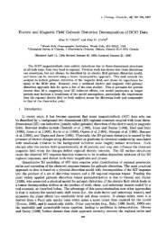
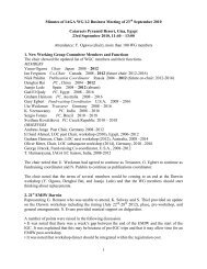
Fig. 13. Two bays as recorded on the profile San Clemente Island-Tucson through<br />
southern California. Prominent Z-variations a t the coastal station La Jolla gradually<br />
diminish toward the open ocean and toward inland. Slight reduction"of the D-amplitude<br />
near the coast in comparison to the D-amplitude at Tucson.<br />
As already stated by Parkinson, coastal anomalies could arise from different<br />
mantle conductivities under continents and oceans. It would imply that<br />
a steep uplift of highly conductive material occurs along the continental slope,<br />
bringing deep induction currents near to the surface below the sea floor. On<br />
the other hand, these anomalies coincide with an outstanding superficial conductivity<br />
contrast and they could be "edge effects" of oceanic eddy currents<br />
which cannot penetrate into the less conducting continental surface layers and<br />
are forced to flow parallel to the coastlines.<br />
Because of the complicated coastal structure in southern California it was<br />
decided to conduct similar observations in central California, where the continental<br />
shelf is just 100 km wide. The station on the Farallon Islands offshore<br />
San Francisco was even within 40 km of the continental slope. Three<br />
lines of field stations were set up perpendicular to the coast and extending<br />
about 400 km inland. These profiles crossed three geological structures,<br />
(a) the California coast range, (b) the San Joaquin valley, (c) the Sierra<br />
Nevada (fig. 21). It should be noted that the San Joaquin valley is a young<br />
embayment, filled with unconsolidated sediments of presumably high conductivity,<br />
in contrast to the poorly conducting granitic bloc of the Sierra<br />
n