You also want an ePaper? Increase the reach of your titles
YUMPU automatically turns print PDFs into web optimized ePapers that Google loves.
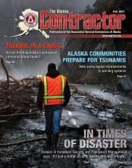
Crooked Creek<br />
Flooding Response<br />
By Jeremy Zidek, DHS&EM Public Affairs<br />
CAMP DENALI, Alaska ... Every<br />
spring, as temperatures rise, the ice along<br />
Alaska’s river systems begins to crack, break<br />
up and move downstream. All too often the<br />
ice stops moving, pinched by a curve in the<br />
river, grounded by a low spot along the<br />
river bed or stacked up on other ice, and<br />
an ice jam results.<br />
In May, an ice jam developed above and<br />
below the community of Crooked Creek on<br />
the Kuskokwim River. Crooked Creek’s 107<br />
full-time residents, survivors of the 2009<br />
spring floods, had taken usual pro active<br />
measures, such as moving vehicles to higher<br />
ground and storing water. However, the<br />
combined ice jams blocked water flow<br />
downstream and water levels in Crooked<br />
Creek began to rise.<br />
Ice and water rushed over the banks,<br />
crushing vehicles, smashing homes and<br />
depositing a field of ice 10 feet thick in the<br />
18<br />
village. Water levels reached 30 feet above<br />
the normal levels, far exceeding flood water<br />
levels current Crooked Creek residents<br />
had ever experienced. The event happened<br />
so quickly that residents fled to higher<br />
ground with nothing more than the clothes<br />
they were wearing.<br />
When Evelyn Thomas, Crooked Creek<br />
tribal president, determined an evacuation<br />
was necessary, she contacted Donlin Creek<br />
Mine. The mine flew 53 evacuees by helicopter<br />
and plane to its facility, with the<br />
youngest being a four-month-old infant.<br />
“Many Crooked Creek residents work<br />
at the mine and it is their closest neighbor.<br />
Like any good neighbor, Donlin Creek<br />
Mine was there to help when called upon,”<br />
said John Madden, director of DHS&EM.<br />
“During any disaster event, the state’s top<br />
priority is the safety of the people affected<br />
by the event. It is heartening to see the mine<br />
has that same priority for its neighbors.”<br />
Before the ice jam occurred, a River<br />
Watch team had flown over the area and<br />
reported that the most dangerous looking<br />
ice on the Kuskokwim was near Crooked<br />
Creek. The River Watch team, a partnership<br />
between DHS&EM and the National<br />
Weather Service River Forecast Center,<br />
provide advanced emergency notification.<br />
“Time and time again, we have seen<br />
that having a hydrologist and an emergency<br />
manager in the area to evaluate river<br />
conditions and provide timely emergency<br />
response assistance is extremely valuable,”<br />
said Claude Denver, DHS&EM incident<br />
commander. “The ability to land in a<br />
community as flood waters rise gives<br />
DHS&EM the opportunity to help an<br />
impacted community make key decisions<br />
early on in the event. That guidance and<br />
decisions have a major impact on the entire<br />
response effort.”<br />
Once flooding began, the Kuskokwim<br />
River Watch team started communicating<br />
with the State Emergency Coordination<br />
Securing the State, Defending the Nation WARRIORS • <strong>Summer</strong> <strong>2011</strong>