Download - Stanford School of Earth Sciences - Stanford University
Download - Stanford School of Earth Sciences - Stanford University
Download - Stanford School of Earth Sciences - Stanford University

Create successful ePaper yourself
Turn your PDF publications into a flip-book with our unique Google optimized e-Paper software.
3D CHARACTERIZATION AND MECHANICS OF BRITTLE DEFORMATION IN<br />
THRUST FAULT RELATED FOLDS<br />
A DISSERTATION<br />
SUBMITTED TO THE DEPARTMENT<br />
OF GEOLOGICAL AND ENVIRONMENTAL SCIENCES<br />
AND THE COMMITTEE ON GRADUATE STUDIES<br />
OF STANFORD UNIVERSITY<br />
IN PARTIAL FULFILLMENT OF THE REQUIREMENTS<br />
FOR THE DEGREE OF<br />
DOCTOR OF PHILOSOPHY<br />
Patricia E. Fiore<br />
November 2006
© Copyright by Patricia E. Fiore 2007<br />
All Rights Reserved<br />
ii
iii
Abstract<br />
This thesis addresses the proposition that a better understanding <strong>of</strong> fractures<br />
will aid in the optimization <strong>of</strong> hydrocarbon recovery in thrust fault related folds.<br />
Fault planes, stratigraphic layers, and stratigraphic growth features interpreted<br />
within a three-dimensional volume <strong>of</strong> seismic reflection data collected over the Elk<br />
Hills Oil Field, Kern County, CA are integrated with mechanical models to develop a<br />
four-dimensional fault evolution history that is structurally, stratigraphically, and<br />
mechanically consistent. The developed fault chronology has direct implications for<br />
the migration and emplacement <strong>of</strong> hydrocarbons. The method introduced here, by<br />
which structural and stratigraphic interpretations are incorporated into a sequence <strong>of</strong><br />
forward mechanical models, represents an effective means <strong>of</strong> constraining the<br />
structural evolution <strong>of</strong> a fault network that developed within a syn-depositional<br />
tectonic setting.<br />
The development <strong>of</strong> fractures in the sedimentary layers <strong>of</strong> Sheep Mountain<br />
anticline, a Laramide asymmetric fault-cored fold <strong>of</strong> the Bighorn Basin <strong>of</strong> Wyoming,<br />
is documented and interpreted as a method <strong>of</strong> constraining the kinematic evolution <strong>of</strong><br />
the fold. The relative chronology, mode <strong>of</strong> formation (opening vs. shearing), and<br />
structural locations <strong>of</strong> these fractures provide the following constraints interpretations<br />
<strong>of</strong> fold kinematics: there was little or no lateral fold propagation and no hinge<br />
migration; limb rotation or limb flexure and stretching operated at different structural<br />
locations during folding.<br />
Field observations <strong>of</strong> sheared fractures in various structural locations across<br />
Sheep Mountain document the role <strong>of</strong> fracture reactivation. Differences in<br />
observations <strong>of</strong> shearing constrain spatial and temporal variations <strong>of</strong> the stress state<br />
across the anticline during folding. Differences in both the formation and reactivation<br />
<strong>of</strong> fracture sets in the forelimb and backlimb indicate that the stress state in the<br />
forelimb was significantly influenced by the underlying fault.<br />
The coupling <strong>of</strong> fracture mapping with analysis <strong>of</strong> high precision GPS<br />
positions collected across patches <strong>of</strong> bedding surfaces at Sheep Mountain provides<br />
insight into the curvature-fracture relationship. Comparison <strong>of</strong> principal curvature<br />
v
magnitudes with fracture measurements indicates that greater curvature correlates with<br />
greater spherical variance <strong>of</strong> fracture sets. Fracture intensities, however, correlate only<br />
loosely with curvature, so fracturing mechanisms other than flexure must be taken into<br />
account.<br />
vi
Preface<br />
Small scale structural heterogeneities (joints, faults, sheared joints) affect the<br />
flow properties <strong>of</strong> reservoirs as discontinuities in the permeability <strong>of</strong> the rock volume,<br />
disrupting both the vertical and lateral transport <strong>of</strong> fluids. Accurate characterization <strong>of</strong><br />
these structures within reservoirs is thus sought for economic purposes. Typically,<br />
these structures are below seismic resolution and direct observation <strong>of</strong> their patterns is<br />
unfeasible, except within boreholes, where spatial coverage is limited. Fracture<br />
clusters <strong>of</strong>ten localize near faults or on folds. Thus, new multi-scale methods for<br />
predicting fracture patterns from subsurface data in which faults and folds are imaged<br />
would play a crucial role in the development <strong>of</strong> hydrocarbon reservoirs.<br />
Additionally, it is <strong>of</strong>ten beneficial from a geological point <strong>of</strong> view to reverse<br />
this relationship and consider faulting and folding with respect to observed fracturing.<br />
In this way, insight into the tectonic forces existing within the crust may be gained.<br />
The establishment <strong>of</strong> a link between faulting, folding, and fracturing would aid<br />
geologists in deducing the deformational history <strong>of</strong> a rock mass based on field<br />
interpretation <strong>of</strong> fractures present within thrust fault related folds. A complete<br />
understanding <strong>of</strong> the mechanics <strong>of</strong> faulting, folding and fracturing is a prerequisite for<br />
this process.<br />
This thesis consists <strong>of</strong> four chapters that are focused on relating common<br />
geological structures, namely faults, folds, and fractures. Elk Hills Anticline, a thrust<br />
fault related growth fold in Kern County, California, and Sheep Mountain Anticline, a<br />
Laramide thrust fault related fold in the Bighorn Basin <strong>of</strong> Wyoming, are two field sites<br />
that provide, respectively, the subsurface and the outcrop data that form the basis for<br />
the analyses included in this work. Three chapters provide insight into the link<br />
between fault and fold evolutions (chapters one, two, and three), two chapters have<br />
implications linking faulting and fracturing (chapters two and three), and three<br />
chapters link folding and fracturing (chapters two, three, and four).<br />
In chapter one, I use elastic models to investigate the evolution <strong>of</strong> the fault<br />
system beneath the Elk Hills anticline. My coauthors for this work are David Pollard,<br />
Bill Currin, and David Miner. Currin and Miner were employees at Occidental <strong>of</strong> Elk<br />
vii
Hills, Inc. at the time <strong>of</strong> the study. They provided the fault and horizon interpretations<br />
that served as input (fault surfaces) and calibration (structure contour maps <strong>of</strong> specific<br />
horizons) for the modeling effort. I interpreted growth structures within the seismic<br />
reflection data and worked with David Pollard to develop a method <strong>of</strong> forward<br />
modeling for observed deformation within a growth faulting environment through a<br />
series <strong>of</strong> iterative steps in which fault geometry evolves. I drafted the manuscript and<br />
all included figures with significant edits suggested by David Pollard. This manuscript<br />
has been accepted for publication in American Association <strong>of</strong> Petroleum Geologists<br />
Bulletin and is currently in press.<br />
The work presented in chapter two represents the initial results <strong>of</strong> a fruitful<br />
collaboration with Nicolas Bellahsen, who, at the time, was a post-doctorate fellow<br />
with David Pollard. Bellahsen spearheaded field efforts in which we collected fracture<br />
measurements at outcrops around Sheep Mountain Anticline. By considering fracture<br />
orientations, modes <strong>of</strong> deformation, and abutting relations, we developed a<br />
chronological fracturing story and were able to use this story to investigate the<br />
kinematics <strong>of</strong> folding at Sheep Mountain. I am second author on this paper after<br />
Bellahsen. I led the thin section interpretation and curvature analysis work, generating<br />
the corresponding figures. I also worked side-by-side with Bellahsen during the<br />
development <strong>of</strong> many <strong>of</strong> the concepts presented in the paper and through the drafting<br />
<strong>of</strong> the paper. David Pollard provided significant conceptual direction during the project<br />
and suggested significant reorganization and edits <strong>of</strong> the paper. This manuscript was<br />
published in the May 2006 issue <strong>of</strong> Journal <strong>of</strong> Structural Geology (v. 28, n.5).<br />
[Reprinted from Journal <strong>of</strong> Structural Geology, v. 28, Bellahsen, N., P. E. Fiore, and<br />
D. D. Pollard, The role <strong>of</strong> fractures in the structural interpretation <strong>of</strong> Sheep Mountain<br />
Anticline, Wyoming, p. 850-867, Copyright 2006, with permission from Elsevier.]<br />
In chapter three, I document the reactivation <strong>of</strong> fractures observed throughout<br />
Sheep Mountain Anticline. This work is coauthored with Nicolas Bellahsen and David<br />
Pollard. To dispel the notion that reactivation <strong>of</strong> fractures at Sheep Mountain may be<br />
lithology dependent, we first present fracture measurements in four different<br />
lithologies. We then discuss how differences observed in shearing at locations across<br />
the fold may constrain the state <strong>of</strong> stress at the time <strong>of</strong> deformation. Nicolas Bellahsen<br />
viii
worked with me in the field, identifying sheared fractures and investigating the spatial<br />
extent <strong>of</strong> shearing for different fracture sets. David Pollard also contributed to field<br />
work and provided invaluable direction and editing for a manuscript resulting from<br />
this work. Submission <strong>of</strong> this manuscript to Journal <strong>of</strong> Structural Geology is<br />
anticipated.<br />
In chapter four I compare characteristics <strong>of</strong> the fracture pattern mapped across<br />
patches <strong>of</strong> bedding surfaces with the magnitude <strong>of</strong> curvature <strong>of</strong> those surfaces.<br />
Although this was the last chapter completed, it was the first concept proposed to me<br />
by David Pollard upon my arrival at <strong>Stanford</strong> – that we should work toward a better<br />
understanding <strong>of</strong> how the shapes <strong>of</strong> surfaces relate to the fractures developed across<br />
those surfaces. I carried out all <strong>of</strong> the field work and analysis involved in this study<br />
and drafted the manuscript. Nicolas Bellahsen and David Pollard are coauthors on this<br />
paper. Work with Nicolas Bellahsen provided a foundation for the fracture<br />
characterization included in this project. David Pollard provided conceptual advice<br />
central to the development <strong>of</strong> the project. The manuscript is currently in preparation<br />
for submission to Journal <strong>of</strong> Structural Geology.<br />
Appendix one took shape while I was considering tectonic boundary conditions<br />
for the modeling included in chapter 1. During an internship at Occidental <strong>of</strong> Elk Hills,<br />
it became clear to me that geoscientists are still in debate over the tectonic setting in<br />
which the anticline formed. In part to justify my work at Elk Hills to Occidental<br />
employees, I felt it necessary to defend our view <strong>of</strong> Elk Hills as developing in response<br />
to a thrusting mechanism. David Pollard, my coauthor for this paper, suggested that we<br />
carry out kinematic calculations for suggested wrenching scenarios. The completion <strong>of</strong><br />
this task, and the results <strong>of</strong> a mechanical modeling effort in which wrenching drives<br />
the deformation, is summed up in a manuscript that has not yet been placed for<br />
publication.<br />
Appendix two is a field guide for Sheep Mountain anticline that I compiled with<br />
assistance from Nicolas Bellahsen and David Pollard for the June 2006 Rock Fracture<br />
Project field trip. It consists <strong>of</strong> a lengthy background section that includes excerpts<br />
from many previous studies at the anticline and then discusses much <strong>of</strong> the work<br />
conducted by Nicolas Bellahsen, David Pollard and me. Much <strong>of</strong> chapter two <strong>of</strong> this<br />
ix
thesis is included in the field guide. Some <strong>of</strong> the concepts developed in chapter three<br />
are included as well, although many <strong>of</strong> these concepts are in their infancy. Since<br />
publication is not intended, I have included the field guide as an appendix for archival<br />
purposes.<br />
x
Acknowledgements<br />
I am grateful to the many people who have contributed to the research presented<br />
in this thesis. Foremost, I thank Dave Pollard for his guidance over the past five years.<br />
He has been an excellent advisor and I truly appreciate the countless hours he has<br />
dedicated to helping me develop both my research and the ability to communicate it to<br />
others. In particular, I thank Dave for thinking <strong>of</strong> my future career when helping me to<br />
consider projects and internships. I also thank my committee members: Atilla Aydin,<br />
Mark Zoback, Steve Graham, and Ronnie Borja for invaluable suggestions and<br />
feedback over the years. I am appreciative <strong>of</strong> the GPS support provided by George<br />
Hilley and Trevor Hebert.<br />
Thanks to my fellow colleagues within the geomechanics research group who<br />
have engaged me in interesting research discussions and enlivened day to day tasks.<br />
Through the years, I have greatly benefited from the field assistance, technical<br />
discussion, and supportive working environment provided by Stephan Bergbauer, Phil<br />
Resor, Kurt Sternl<strong>of</strong>, Ian Mynatt, Ashley Griffith, Ole Kaven, Pete Lovely, Nico<br />
Bellahsen, Frantz Maerten, Laurent Maerten, Eric Flodin, Nick Davatzes, Brita<br />
Graham, Jordan Muller, Fabrizio Agosta, Laura Chiaramonte, Joe Gonzales, and Chris<br />
Wilson. In particular, Nico Bellahsen has been a great field partner and collaborator. I<br />
have learned a vast amount through interactions with Nico in both the field and the<br />
<strong>of</strong>fice, and much <strong>of</strong> my Sheep Mountain work would not have been possible without<br />
his efforts and enthusiasm.<br />
Beyond the <strong>Stanford</strong> community, I owe thanks to Stan Stearns and Radu<br />
Girbacea for helping turn a summer internship project with Occidental Oil and Gas<br />
into a true research project and to Peter Hennings for introducing me to Sheep<br />
Mountain six years ago during an internship at Phillips Petroleum Co.<br />
Financial support for my studies came from many sources. Project specific funds<br />
were provided by an NSF Tectonics Program Grant No. EAR-0125935 and an NSF<br />
Collaboration in Mathematical Geosciences Program Grant No. EAR-04177521.<br />
Additional funds were provided by the <strong>Stanford</strong> Rock Fracture Project, the <strong>Stanford</strong><br />
xi
<strong>University</strong> Department <strong>of</strong> Geological and Environmental <strong>Sciences</strong>, and the <strong>Stanford</strong><br />
McGee Grant.<br />
My family has provided endless support throughout my education. From an<br />
early age, my parents fueled my curiosity and encouraged my learning. I owe the<br />
dedication required to complete this thesis to them. My three sisters have been a<br />
constant source <strong>of</strong> personal support, providing prospective and a fun outlet from the<br />
geological world. Finally, I am indebted to my husband, Jeff, for his unwavering love,<br />
support, and patience during my final months at <strong>Stanford</strong>, despite the many miles<br />
between us.<br />
xii<br />
PEF, November 20 th , 2006
Table <strong>of</strong> Contents<br />
Abstract ………………………………...………………………………………….…. v<br />
Preface ………………………………………………………………………………. vii<br />
Acknowledgements ………………………………………………………………….. xi<br />
Table <strong>of</strong> Contents …………………………………………………………………... xiii<br />
List <strong>of</strong> Tables …………………………………………………………...………… xviii<br />
List <strong>of</strong> Illustrations …………………………………………………………………. xix<br />
Chapter 1: Mechanical and stratigraphic constraints on the evolution <strong>of</strong> faulting<br />
at Elk Hills, CA …………………………………………………………………. 1<br />
Abstract ....................................................................................................................1<br />
Introduction ..............................................................................................................1<br />
Regional geological setting ......................................................................................4<br />
Elk Hills Field .......................................................................................................... 6<br />
Structural interpretation............................................................................................7<br />
Velocity model .........................................................................................................9<br />
Stratigraphy ............................................................................................................10<br />
Stratigraphic constraints .........................................................................................10<br />
Pseudowells ........................................................................................................ 10<br />
Pseudowell interpretations: Western Elk Hills................................................ 12<br />
Pseudowell interpretations: Eastern Elk Hills ................................................. 15<br />
Bedding relationships ......................................................................................... 15<br />
Bedding relationship interpretations................................................................ 15<br />
Isochores............................................................................................................. 17<br />
Isochore interpretations: McDonald to Base Reef Ridge................................ 19<br />
Isochore interpretations: Base Reef Ridge to Calitroleum.............................. 21<br />
Isochore interpretations: Calitroleum to Wilhelm........................................... 23<br />
Isochore interpretations: Wilhelm to MYA 4-A ............................................. 24<br />
Stratigraphic constraints on fault evolution............................................................24<br />
Mechanical modeling ............................................................................................. 24<br />
Boundary conditions........................................................................................... 26<br />
Model increments................................................................................................ 30<br />
Model calibration ............................................................................................... 32<br />
Model results....................................................................................................... 33<br />
Discussion ..............................................................................................................35<br />
Modeled and interpreted discrepancies.............................................................. 36<br />
Tectonic strain analysis ...................................................................................... 37<br />
Implications for hydrocarbon migration ............................................................ 39<br />
Conclusions ............................................................................................................41<br />
Acknowledgements ................................................................................................42<br />
References ..............................................................................................................42<br />
xiii
Chapter 2: The role <strong>of</strong> fractures in the structural interpretation <strong>of</strong> Sheep<br />
Mountain anticline, Wyoming ………………………………………………… 49<br />
Abstract ..................................................................................................................49<br />
Introduction ............................................................................................................49<br />
Geological and tectonic setting ..............................................................................53<br />
Methods ..................................................................................................................56<br />
Fracture sampling .............................................................................................. 56<br />
Data processing .................................................................................................. 59<br />
Curvature calculation......................................................................................... 61<br />
Structural data ........................................................................................................63<br />
Northeastern forelimb ........................................................................................ 63<br />
Southwestern backlimb ...................................................................................... 68<br />
Hinge................................................................................................................... 71<br />
Northern nose ..................................................................................................... 75<br />
Interpretation .......................................................................................................... 76<br />
Pre-existing fractures ......................................................................................... 76<br />
Early Laramide compression: onset <strong>of</strong> faulting and folding .............................. 78<br />
Fold growth: intermediate stage......................................................................... 81<br />
Fold growth: late stage....................................................................................... 82<br />
Conclusions ............................................................................................................83<br />
Acknowledgements ................................................................................................84<br />
References ..............................................................................................................84<br />
Chapter 3: Fracture reactivation at Sheep Mountain anticline: insight on the<br />
mechanics <strong>of</strong> folding and constraints on the stress field …………………….. 91<br />
Abstract ..................................................................................................................91<br />
Introduction ............................................................................................................92<br />
Geological background...........................................................................................93<br />
Field data ................................................................................................................99<br />
Systematic fracture sets ...................................................................................... 99<br />
Forelimb ........................................................................................................ 102<br />
Backlimb........................................................................................................ 102<br />
Hinge ............................................................................................................. 104<br />
Shearing datas .................................................................................................. 104<br />
Forelimb ........................................................................................................ 106<br />
Backlimb........................................................................................................ 110<br />
Hinge ............................................................................................................. 113<br />
Analysis <strong>of</strong> field data............................................................................................113<br />
Interpretation <strong>of</strong> shearing................................................................................. 113<br />
Forelimb ........................................................................................................ 113<br />
Backlimb........................................................................................................ 115<br />
Lithological control on fracturing .................................................................... 115<br />
Set V fractures................................................................................................... 118<br />
Stress field constraints...................................................................................... 120<br />
Constraints on spatial variation in stress orientation: conjugate shearing..... 121<br />
xiv
Spatial variation in stress orientation: opposite senses <strong>of</strong> shearing............... 121<br />
Constraints on spatial variation in stress field magnitude: set I fractures ..... 128<br />
Discussion ............................................................................................................134<br />
Kinematics <strong>of</strong> shearing and folding.................................................................. 134<br />
Implications for the mechanics <strong>of</strong> fracturing in a thrust fault related folds..... 134<br />
Acknowledgements ..............................................................................................136<br />
References ............................................................................................................ 136<br />
Chapter 4: Curvature and fracturing based on GPS data collected at Sheep<br />
Mountain anticline, WY ……………………………………………………… 141<br />
Abstract ................................................................................................................141<br />
Introduction ..........................................................................................................141<br />
Geological setting.................................................................................................142<br />
Methodology ........................................................................................................143<br />
GPS data collection .......................................................................................... 143<br />
GPS data filtering ............................................................................................. 147<br />
Curvature calculation....................................................................................... 148<br />
Fracture data collection ................................................................................... 148<br />
Fracture data analysis...................................................................................... 148<br />
Field data ..............................................................................................................149<br />
GPS data........................................................................................................... 149<br />
Fracture data .................................................................................................... 151<br />
Curvature analysis ................................................................................................158<br />
Discussion ............................................................................................................ 163<br />
Curvature analyses ........................................................................................... 163<br />
Relating curvature analysis to fracture measurements .................................... 163<br />
Conclusions ..........................................................................................................167<br />
Acknowledgements .............................................................................................. 167<br />
References ............................................................................................................ 167<br />
Appendix 1: Tectonic shortening style in the Southern San Joaquin Valley,<br />
Revisited ………………………………………………………………………. 171<br />
Abstract ................................................................................................................171<br />
Introduction ..........................................................................................................172<br />
Previous work.......................................................................................................175<br />
Shearing calculations............................................................................................177<br />
Pure shear ...................................................................................................... 178<br />
Simple shear................................................................................................... 178<br />
Implications <strong>of</strong> shearing-related rotation on relative plate velocities........... 179<br />
Discussion ............................................................................................................180<br />
Analysis <strong>of</strong> shearing calculations................................................................... 180<br />
Variation in isochore trends at Elk Hills ....................................................... 184<br />
Analysis <strong>of</strong> a wrenching growth mechanism at Elk Hills............................... 184<br />
Conclusions ..........................................................................................................186<br />
Acknowledgements ..............................................................................................188<br />
References ............................................................................................................188<br />
xv
Appendix 2: The Rock Fracture Project field trip, Sheep Mountain Anticline,<br />
WY, 2006………………………………………………………………………. 193<br />
Introduction ..........................................................................................................194<br />
Themes: ................................................................................................................194<br />
Fracture characterization at the outcrop ......................................................... 194<br />
Fracture characterization over the fold............................................................ 195<br />
Fold-thrust fault relationships based on fracture patterns............................... 195<br />
Tectonic history revealed by fracture patterns................................................. 195<br />
Field Trip Stops:...................................................................................................196<br />
First Day ........................................................................................................ 196<br />
Second Day.................................................................................................... 196<br />
DAY 1 ..................................................................................................................199<br />
Stop 1: Geology <strong>of</strong> the greater region ..................................................................200<br />
Objectives.......................................................................................................... 200<br />
Key Points......................................................................................................... 200<br />
Tectonic setting <strong>of</strong> Laramide Orogeny ............................................................. 200<br />
Structural styles <strong>of</strong> Laramide folds and thrust faults........................................ 202<br />
Stratigraphy <strong>of</strong> the Bighorn Basin.................................................................... 204<br />
Structures surrounding Sheep Mountain .......................................................... 207<br />
Structural interpretations for Sheep Mountain anticline.................................. 213<br />
Stop 2: Fold shape ................................................................................................222<br />
Objectives.......................................................................................................... 222<br />
Key Points......................................................................................................... 222<br />
Stop 3: Fracture introduction; nose fractures .......................................................224<br />
Objectives.......................................................................................................... 224<br />
Key Points......................................................................................................... 224<br />
Previous fracture studies at Sheep Mountain................................................... 224<br />
Methods <strong>of</strong> fracture characterization ............................................................... 229<br />
Fracture interpretation..................................................................................... 231<br />
Fracture characterization in the nose .............................................................. 233<br />
DAY 2 ..................................................................................................................237<br />
Stop 4: Backlimb fractures ...................................................................................238<br />
Objectives.......................................................................................................... 238<br />
Key Points......................................................................................................... 238<br />
Overview ........................................................................................................... 239<br />
Kinematic Indicators ........................................................................................ 241<br />
Fracture characterization in the backlimb ....................................................... 242<br />
Stop 5: Backlimb fractures and shearing <strong>of</strong> Set I.................................................248<br />
Objectives.......................................................................................................... 248<br />
Key Points......................................................................................................... 248<br />
Shearing <strong>of</strong> Set I fractures in the backlimb....................................................... 249<br />
Stop 6: Backlimb fractures ...................................................................................253<br />
Objectives.......................................................................................................... 253<br />
Key Points......................................................................................................... 253<br />
Fracture characterization................................................................................. 254<br />
Shearing at site ................................................................................................. 258<br />
xvi
Role <strong>of</strong> thumb in fracture variation .................................................................. 264<br />
Stop 7: Forelimb and hinge fractures ...................................................................267<br />
Objectives.......................................................................................................... 267<br />
Key Points......................................................................................................... 267<br />
Fracture characterization in the forelimb ........................................................ 268<br />
Shearing (reactivation) <strong>of</strong> Set I fractures in the forelimb................................. 271<br />
Bedding plane slip in the forelimb.................................................................... 272<br />
Fracture characterization at site ...................................................................... 275<br />
Fracture characterization in the hinge............................................................. 281<br />
Shearing in the hinge ........................................................................................ 285<br />
Stop 8: Fracture synthesis..................................................................................... 286<br />
Objectives.......................................................................................................... 286<br />
Key Points......................................................................................................... 286<br />
Stages <strong>of</strong> fracturing........................................................................................... 288<br />
Pre-existing fractures..................................................................................... 288<br />
Early Laramide compression: onset <strong>of</strong> faulting and folding ......................... 288<br />
Fold growth: intermediate stage .................................................................... 289<br />
Fold growth: late stage .................................................................................. 289<br />
Constraints on fold kinematics ......................................................................... 292<br />
Fixed hinge .................................................................................................... 292<br />
Understanding spatial variations .................................................................... 293<br />
Set III fractures.............................................................................................. 293<br />
Set II fractures ............................................................................................... 295<br />
Role <strong>of</strong> shearing <strong>of</strong> set I fractures..................................................................... 299<br />
References ............................................................................................................ 302<br />
xvii
List <strong>of</strong> Tables<br />
Table 1.1. Ages <strong>of</strong> stratigraphic horizons; model increments; applied strains.............31<br />
Table 4.1. Fisher statistics for fracture sets at surveyed pavements...........................155<br />
Table 4.2. Extreme values <strong>of</strong> principal normal curvatures.........................................159<br />
xviii
List <strong>of</strong> Illustrations<br />
Figure 1.1. Location <strong>of</strong> the Elk Hills Oil Field...............................................................5<br />
Figure 1.2. Structure <strong>of</strong> the Elk Hills Oil Field ..............................................................8<br />
Figure 1.3. Tertiary stratigraphic column for the Elk Hills Oil Field...........................11<br />
Figure 1.4. Cross sections and pseudowells .................................................................13<br />
Figure 1.5. Stratigraphic bedding relationships............................................................16<br />
Figure 1.6. Tracing <strong>of</strong> seismic line exhibiting stratigraphic bedding relationships......18<br />
Figure 1.7 Interpreted and modeled isochore maps.....................................................20<br />
Figure 1.8. Isochore signatures related to fault activity................................................22<br />
Figure 1.9. Conceptual model <strong>of</strong> fault evolution..........................................................25<br />
Figure 1.10. Remote boundary conditions applied to one step models ........................29<br />
Figure 1.11. Interpreted and modeled structure contour maps .....................................34<br />
Figure 1.12. Remote boundary conditions applied to iterative models ........................38<br />
Figure 2.1. Geology <strong>of</strong> Sheep Mt. ................................................................................52<br />
Figure 2.2. Cross section through Sheep Mt.................................................................54<br />
Figure 2.3. Stratigraphic column for Sheep Mt. ...........................................................54<br />
Figure 2.4. Fracture measurements in the limbs and hinge at Sheep Mt......................57<br />
Figure 2.5. Fracture measurements in the nose at Sheep Mt. .......................................58<br />
Figure 2.6. Sample sites for microscope analysis.........................................................60<br />
Figure 2.7. Curvature map <strong>of</strong> Sheep Mt. ......................................................................62<br />
Figure 2.8. Fracture patterns in the forelimb ................................................................64<br />
Figure 2.9. Thin section <strong>of</strong> a set I fracture in the forelimb...........................................65<br />
Figure 2.10. Reactivated set I fractures in the forelimb................................................66<br />
Figure 2.11. Fracture pattern in the backlimb...............................................................67<br />
Figure 2.12. Thin section <strong>of</strong> a set I fracture in the backlimb........................................67<br />
Figure 2.13. Thin sections <strong>of</strong> set II, III, and IV fractures in the backlimb ...................69<br />
Figure 2.14. Set IV fractures in the backlimb...............................................................70<br />
Figure 2.15. Thin sections <strong>of</strong> set I and II fractures in the hinge ...................................70<br />
Figure 2.16. Fracture pattern in the hinge.....................................................................72<br />
Figure 2.17. Fracture pattern in the hinge <strong>of</strong> the nose ..................................................73<br />
Figure 2.18. Fracture pattern in the backlimb <strong>of</strong> the nose ............................................74<br />
Figure 2.19. Stages <strong>of</strong> fracturing at Sheep Mt..............................................................77<br />
Figure 3.1. Geology <strong>of</strong> the Bighorn Mts./Bighorn Basin area......................................94<br />
Figure 3.2. Geological map <strong>of</strong> Sheep Mt......................................................................96<br />
Figure 3.3. Stratigraphic column for the Bighorn Basin ..............................................97<br />
Figure 3.4. Schematic drawing <strong>of</strong> Sheep Mt. fracture pattern .....................................98<br />
Figure 3.5. Forelimb, backlimb, and hinge fracture measurements ...........................100<br />
Figure 3.6. Abutting relationships for set V joints .....................................................103<br />
Figure 3.7. Locations and types <strong>of</strong> shearing observations at Sheep Mt. ....................105<br />
Figure 3.8. Set I reactivated fractures in the forelimb ................................................107<br />
Figure 3.9. Sheared set I fracture in the forelimb .......................................................108<br />
Figure 3.10. Sheared set I fractures and set II joints in the backlimb.........................109<br />
Figure 3.11. Sheared set V joints in the backlimb......................................................111<br />
Figure 3.12. Sheared set I fractures in the backlimb ..................................................112<br />
Figure 3.13. Fracture pattern in the hinge...................................................................112<br />
xix
Figure 3.14. Shearing domains ...................................................................................114<br />
Figure 3.15. Conceptual model <strong>of</strong> fracture, fold, and shearing development ............116<br />
Figure 3.16. Sets II and V abutting relationship.........................................................119<br />
Figure 3.17. Conjugate shearing along sets II and V..................................................122<br />
Figure 3.18. Spatial constraints on local principal stress directions...........................123<br />
Figure 3.19. Conceptual drawing <strong>of</strong> opposite senses <strong>of</strong> shear along parallel joints...123<br />
Figure 3.20. Stress states for which pre-existing fractures will slip...........................126<br />
Figure 3.21. Remote strains consistent with shearing observations ...........................129<br />
Figure 3.22. Mohr-Coulomb analysis investigating mechanics <strong>of</strong> set I reactivation 131<br />
Figure 3.23. Thin sections <strong>of</strong> set I fractures in the hinge and backlimb.....................133<br />
Figure 3.24. Kinematics <strong>of</strong> shearing at Sheep Mt. .....................................................135<br />
Figure 4.1. Geological map <strong>of</strong> Sheep Mt....................................................................144<br />
Figure 4.2. Various methods <strong>of</strong> post-processing GPS data ........................................146<br />
Figure 4.3. GPS data collected at Sheep Mt. ..............................................................150<br />
Figure 4.4. Fracture orientation data...........................................................................152<br />
Figure 4.5. Fracture sets present at studied pavements ..............................................154<br />
Figure 4.6. Intensity mesurements..............................................................................157<br />
Figure 4.7. Relative elevations <strong>of</strong> collected GPS data................................................160<br />
Figure 4.8. Filtered GPS data .....................................................................................161<br />
Figure 4.9. Maximum and minimum normal curvatures across GPS6 and GPS7 .....162<br />
Figure 4.10. Photographs <strong>of</strong> GPS6 and GPS7 ............................................................164<br />
Figure 4.11. Spherical variance <strong>of</strong> fracture sets at study sites....................................165<br />
Figure A1.1. Location <strong>of</strong> Elk Hills .............................................................................173<br />
Figure A1.2. Schematic model <strong>of</strong> a compressional flower structure..........................174<br />
Figure A1.3. Structure <strong>of</strong> Elk Hills.............................................................................181<br />
Figure A1.4. Isochore maps at Elk Hills.....................................................................183<br />
Figure A1.5. Elastic displacement field for a flower structure model <strong>of</strong> Elk Hills ... 187<br />
Figure A2.0. Aerial photograph <strong>of</strong> Sheep Mt.............................................................193<br />
Figure A2.1. Tectonic map <strong>of</strong> Wyoming....................................................................194<br />
Figure A2.2. Sheep Mt. field trip stops ......................................................................196<br />
Figure A2.3. Geological map <strong>of</strong> Sheep Mt.................................................................197<br />
Figure A2.4. Structural map <strong>of</strong> Sheep Mt...................................................................198<br />
Figure A2.5. Road map to Sheep Mt. .........................................................................199<br />
Figure A2.6. Day 1 field trip stops .............................................................................199<br />
Figure A2.7. Two modes <strong>of</strong> subduction .....................................................................201<br />
Figure A2.8. Thrust fault interpretation <strong>of</strong> Laramide deformation ............................202<br />
Figure A2.9. Drape fold interpretation <strong>of</strong> Laramide deformation ..............................203<br />
Figure A2.10. Stratigraphic column <strong>of</strong> Bighorn Basin...............................................205<br />
Figure A2.11. Photograph <strong>of</strong> stratigraphy at the NW nose <strong>of</strong> Sheep Mt....................206<br />
Figure A2.12. Stratigraphic column <strong>of</strong> Sheep Mt.......................................................206<br />
Figure A2.13. Geological map <strong>of</strong> the NE Bighorn Basin...........................................207<br />
Figure A2.14. Major folds within the NE Bighorn Basin...........................................208<br />
Figure A2.15. Synthetic structure contour map <strong>of</strong> the NE Bighorn Basin .................209<br />
Figure A2.16. Strain energy density models <strong>of</strong> the NE Bighorn Basin......................211<br />
Figure A2.17. Cross section through the Bighorn Mts. and NE Bighorn Basin.........212<br />
Figure A2.18. Interpretation <strong>of</strong> Sheep Mt. structure: Hennier and Spang, 1983........313<br />
xx
Figure A2.19. Interpretation <strong>of</strong> Sheep Mt. structure: Forster et al., 1996 ..................214<br />
Figure A2.20. Interpretation <strong>of</strong> Sheep Mt. structure: Brown, 1984 ...........................214<br />
Figure A2.21. Relationship btwn Sheep Mt. and Bighorn Mts.: Forster et al., 1996 .215<br />
Figure A2.22. Interpretation <strong>of</strong> Sheep Mt. structure: Stanton and Erslev, 2002 ........215<br />
Figure A2.23. Structure <strong>of</strong> the Torchlight Field ........................................................216<br />
Figure A2.24. Tectonic map <strong>of</strong> the NE Bighorn Basin ..............................................217<br />
Figure A2.25. Structure contour map <strong>of</strong> Sheep Mt. ...................................................218<br />
Figure A2.26. Model setup to test fault geometry at Sheep Mt..................................219<br />
Figure A2.27. Results <strong>of</strong> heuristic tests <strong>of</strong> fault geometry at Sheep Mt.....................220<br />
Figure A2.28. Basemap for 2D seismic reflection pr<strong>of</strong>iles near Sheep Mt................221<br />
Figure A2.29. Photographs <strong>of</strong> hinge...........................................................................222<br />
Figure A2.30. Photograph showing topographic high................................................223<br />
Figure A2.31. Fracture pattern map: Harris et al., 1960.............................................225<br />
Figure A2.32. Iso-fracture map: Harris et al., 1960....................................................226<br />
Figure A2.33. Joint frequencies: Johnson et al., 1965................................................228<br />
Figure A2.34. Characterizing fracture orientations ....................................................229<br />
Figure A2.35. Characterizing mode <strong>of</strong> deformation...................................................229<br />
Figure A2.36. Characterizing abutting relationships..................................................230<br />
Figure A2.37. Fracture pattern in the hinge <strong>of</strong> the nose .............................................231<br />
Figure A2.38. Stereonets for fracture measurements at site 2....................................231<br />
Figure A2.39. Photo and interpretation <strong>of</strong> fractures at site 2......................................232<br />
Figure A2.40. Photo and interpretation <strong>of</strong> fractures at site 2......................................232<br />
Figure A2.41. Rose diagrams <strong>of</strong> fracture measurements in the nose ........................ 234<br />
Figure A2.42. Fracture pattern in the hinge <strong>of</strong> the nose .............................................235<br />
Figure A2.43. Fracture pattern in the backlimb <strong>of</strong> the nose .......................................236<br />
Figure A2.44. Field trip driving route ........................................................................237<br />
Figure A2.45. Stop 4 location.....................................................................................238<br />
Figure A2.46. Pavement at site 8................................................................................239<br />
Figure A2.47. Fracture pattern at site 8 ......................................................................240<br />
Figure A2.48. Rib marks and hackle along joint surface at site 8..............................241<br />
Figure A2.49. Shear along a set II fracture at site 8 ...................................................241<br />
Figure A2.50. Aerial photograph <strong>of</strong> backlimb <strong>of</strong> Sheep Mt.......................................242<br />
Figure A2.51. Backlimb stereonet..............................................................................243<br />
Figure A2.52. Backlimb fracture measurements ........................................................244<br />
Figure A2.53. Thin section <strong>of</strong> a set I fracture in the backlimb...................................245<br />
Figure A2.54. Thin section <strong>of</strong> a set II fracture in the backlimb..................................245<br />
Figure A2.55. Thin section <strong>of</strong> a set III fracture in the backlimb ................................246<br />
Figure A2.56. Thin section <strong>of</strong> a set IV fracture in the backlimb .............................. 246<br />
Figure A2.57. Photographs <strong>of</strong> set IV fractures in the backlimb .................................247<br />
Figure A2.58. Fractured pavement at site 72 in the backlimb....................................248<br />
Figure A2.59. Left-lateral shear along set I fractures at site 72 in the backlimb........249<br />
Figure A2.60. Left-lateral shear along a set I fracture at site 72 in the backlimb ......250<br />
Figure A2.61. Left-lateral shear along a set I fracture at site 72 in the backlimb ......250<br />
Figure A2.62. Left-lateral shear along set I fractures at site 74 in the backlimb........251<br />
Figure A2.63. Interpretation <strong>of</strong> fractured pavement at site 72....................................252<br />
Figure A2.64. Photograph <strong>of</strong> stop 6 sites ...................................................................253<br />
xxi
Figure A2.65. Stereonets <strong>of</strong> fracture measurements at stop 6 sites ............................254<br />
Figure A2.66. Interpretation <strong>of</strong> fractured pavement at site 81....................................255<br />
Figure A2.67. Set IV fractures at site 81 ....................................................................255<br />
Figure A2.68. Photograph and interpretation <strong>of</strong> site 22 pavement.............................256<br />
Figure A2.69. Photograph and interpretation <strong>of</strong> fractures at site 22 ..........................257<br />
Figure A2.70. Interpretation <strong>of</strong> stages <strong>of</strong> fracture formation at site 22 ......................257<br />
Figure A2.71. Photograph and interpretation <strong>of</strong> conjugate shearing at site 22 ..........258<br />
Figure A2.72. Left-lateral shear along a set V fracture at site 22...............................259<br />
Figure A2.73. Right-lateral shear along a set II fracture at site 22.............................259<br />
Figure A2.74. Interpretation <strong>of</strong> a sheared set V fracture at site 22.............................260<br />
Figure A2.75. Left-lateral shear along a set V fracture at site 22...............................261<br />
Figure A2.76. Right-lateral shear along a set II fracture at site 15............................ 262<br />
Figure A2.77. Bedding plane slip at site 22 in the backlimb......................................263<br />
Figure A2.78. Backlimb fracture data highlighting set V fractures ...........................264<br />
Figure A2.79. Left-lateral shear along a set V fracture in the backlimb ....................265<br />
Figure A2.80. Elastic model setup with idealized main and thumb thrust faults .......266<br />
Figure A2.81. Most tensile stress field resulting from slip along underlying faults...266<br />
Figure A2.82. Photograph <strong>of</strong> the forelimb <strong>of</strong> Sheep Mt.............................................267<br />
Figure A2.83. Forelimb fracture measurements.........................................................268<br />
Figure A2.84. Forelimb fracture patterns ...................................................................269<br />
Figure A2.85. Thin section <strong>of</strong> a set I fracture in the forelimb ....................................270<br />
Figure A2.86. Reactivated set I fractures in the forelimb...........................................271<br />
Figure A2.87. Splay fractures indicating bedding plane slip in the forelimb.............272<br />
Figure A2.88. Polished underside <strong>of</strong> a bedding plane in the forelimb .......................273<br />
Figure A2.89. Slickenlines along a bedding plane in the forelimb ............................273<br />
Figure A2.90. Conceptual model <strong>of</strong> flexural slip: Twiss and Moores, 1992..............274<br />
Figure A2.91. Interpretation <strong>of</strong> bedding plane slip along the rivercut at Sheep Mt. ..274<br />
Figure A2.92. Photograph <strong>of</strong> the forelimb; location <strong>of</strong> site 12...................................275<br />
Figure A2.93. Stratigraphy at site 12..........................................................................276<br />
Figure A2.94. Tensleep pavement at site 12...............................................................276<br />
Figure A2.95. Stereonets <strong>of</strong> measurements in the Tensleep at site 12. ......................277<br />
Figure A2.96. Set I reactivated fractures at site 12.....................................................277<br />
Figure A2.97. Slickenlines along set I reactivated fracture surfaces at site 12 ..........278<br />
Figure A2.98. Limey sandstone pavement at site 12..................................................279<br />
Figure A2.99. Stereonets <strong>of</strong> measurements in the limey sandstone at site 12............279<br />
Figure A2.100. Phosphoria pavement SE <strong>of</strong> site 11...................................................280<br />
Figure A2.101. Stereonets <strong>of</strong> measurements in the Phosphoria at site 12..................280<br />
Figure A2.102. Photograph <strong>of</strong> the hinge ....................................................................281<br />
Figure A2.103. Hinge fracture measurements............................................................282<br />
Figure A2.104. Thin sections <strong>of</strong> set I and set II fractures in the hinge.......................283<br />
Figure A2.105. Fracture pattern in the hinge..............................................................284<br />
Figure A2.106. Dispersion in orientation <strong>of</strong> hinge fracture sets.................................285<br />
Figure A2.107. Intense fracturing within the Madison Fm. in the hinge ...................285<br />
Figure A2.108. Photograph <strong>of</strong> site 10.........................................................................286<br />
Figure A2.109. Sandstone fracture measurements in the limbs and hinge.................287<br />
Figure A2.110. Stages <strong>of</strong> fracture and fold development...........................................291<br />
xxii
Figure A2.111. Mechanism <strong>of</strong> hinge perpendicular jointing: Gross et al., 1998 .......292<br />
Figure A2.112. Curvature map <strong>of</strong> Sheep Mt. .............................................................293<br />
Figure A2.113. Geometry for elastic model investigating set II development...........295<br />
Figure A2.114. Modeled elastic displacements and most tensile stress field.............296<br />
Figure A2.115. Correlation <strong>of</strong> model results and field observations..........................297<br />
Figure A2.116. Conceptual model <strong>of</strong> folding at Sheep Mt.........................................298<br />
Figure A2.117. Conceptual model <strong>of</strong> set IR fractures formed in the forelimb...........299<br />
Figure A2.118. Stages <strong>of</strong> fracturing and shearing <strong>of</strong> set I fractures ...........................300<br />
Figure A2.119. Proximity <strong>of</strong> a stress state to brittle failure........................................301<br />
xxiii
xxiv
Chapter 1<br />
Mechanical and stratigraphic constraints on the evolution <strong>of</strong> faulting<br />
at Elk Hills, CA<br />
Abstract<br />
To unravel the four-dimensional evolution <strong>of</strong> the Elk Hills Oil Field, Kern<br />
County, CA we integrate seismically interpreted fault surfaces, stratigraphic units, and<br />
stratigraphic features with mechanical models. Correspondence <strong>of</strong> synthetic<br />
stratigraphic surfaces, deformed by modeled vertical displacement fields, to<br />
seismically interpreted stratigraphic surfaces represented on structure contour maps<br />
suggests that the tectonic history described here is structurally, stratigraphically, and<br />
mechanically consistent, placing constraints on the regional deformation mechanism<br />
and local structure. During the time period investigated, Middle Miocene to present,<br />
the eastern and the western parts <strong>of</strong> the Elk Hills Anticline developed in response to a<br />
regional horizontal shortening oriented at about 035°. The apparent bend in the trend<br />
<strong>of</strong> the anticline, from northwest-southeast in the western part <strong>of</strong> the field, to east-west<br />
in the eastern part <strong>of</strong> the field is generated by the intersection <strong>of</strong> two distinct fault<br />
systems. In both fault systems, north dipping fault surfaces are backthrusts <strong>of</strong> older<br />
south dipping faults. These results have direct implications for the migration and<br />
emplacement <strong>of</strong> hydrocarbons at Elk Hills, suggesting that Upper Miocene Stevens<br />
turbidite oil pools were derived from sources to the south. Additionally, this study<br />
indicates that the method by which stratigraphic and structural interpretations are<br />
incorporated into a sequence <strong>of</strong> forward mechanical models represents an effective<br />
means <strong>of</strong> constraining the structural evolution <strong>of</strong> a fault network that developed within<br />
a syn-depositional tectonic setting.<br />
Introduction<br />
At Elk Hills Oil Field, Kern County, CA better knowledge <strong>of</strong> the present day and<br />
evolutionary structure <strong>of</strong> the underlying faults would improve recovery efforts. Gross<br />
fault geometry has implications for the existence <strong>of</strong> hydrocarbon traps and the<br />
trajectories <strong>of</strong> wellbores, while evolutionary structure has implications for the timing<br />
1
<strong>of</strong> hydrocarbon migration and entrapment. Previous studies have considered the<br />
current day fault geometry at Elk Hills (Nicholson, 1990; Imperato, 1995), and a<br />
recently published geochemical analysis <strong>of</strong> various oils constrains the timing <strong>of</strong><br />
emplacement <strong>of</strong> specific oil pools (Zumberge et al., 2005). To date, however, there has<br />
not been a well documented study <strong>of</strong> the growth <strong>of</strong> the subsurface faults at Elk Hills<br />
through time.<br />
A three-dimensional seismic reflection volume acquired over the field in 1999<br />
images the shallow fold and fault geometry, for the first time making such a study<br />
feasible. Although the existence <strong>of</strong> this seismic reflection volume greatly enhances<br />
efforts to determine the history <strong>of</strong> faulting at Elk Hills, two issues require further<br />
attention. As in many cases, the resolution <strong>of</strong> the data at Elk Hills decreases with<br />
depth, and so the deep fault geometry, specifically how faults intersect at depth,<br />
remains debatable. Additionally, evolutionary structure is not directly observable<br />
within the three-dimensional seismic reflection data volume, as time is not<br />
represented.<br />
Recent literature <strong>of</strong>fers a methodology to help constrain fault geometry and<br />
timing using mechanical models. Savage and Cooke (2004) present the displacement<br />
fields resulting from heuristic models with simple fault geometries for a field area<br />
where no faults are directly observable, asserting that the geometry <strong>of</strong> mechanically<br />
interacting faults can be constrained by the distributions <strong>of</strong> their displacement fields.<br />
Muller and Aydin (2005) and Resor et al. (2005) use mechanical models to investigate<br />
recent earthquakes where fault geometry is obscure, citing plausible fault geometries<br />
as those that produce modeled elastic displacement fields closely resembling observed<br />
displacements. These studies represent one episode <strong>of</strong> deformation, wherein fault<br />
geometry is static. Elk Hills is a growth fold, and the seismic reflection data reveal that<br />
not all faults have the same history <strong>of</strong> activity, so this modeling approach must be<br />
tailored to incorporate the different stages <strong>of</strong> fault evolution.<br />
Prior structural studies document how various geological and geophysical<br />
observations can be integrated to constrain the growth history <strong>of</strong> faults in cases where<br />
faults and folds are imaged adequately. For example, Medwedeff (1989), Suppe et al.<br />
(1992), Bloch et al. (1993), Shaw and Suppe (1996), and Shaw et al. (2002) show that<br />
2
growth wedges can be analyzed to determine intervals <strong>of</strong> fault movement along a<br />
single fault plane and to distinguish pre-, syn-, and post-faulting strata. Stratigraphic<br />
signatures present within the seismic reflection data at the Elk Hills Oil Field indicate<br />
that structural development and deposition were coeval, thus motivating a similar<br />
analysis. At Elk Hills, however, activity along multiple intersecting faults presents a<br />
complex history, requiring that numerous growth signatures be interpreted.<br />
In our study <strong>of</strong> Elk Hills, we show how these two previously published<br />
techniques can be combined to develop a fault history that is structurally,<br />
stratigraphically, and mechanically consistent. In light <strong>of</strong> pr<strong>of</strong>iles <strong>of</strong> interval<br />
thicknesses, stratigraphic bedding relationships, and isochore maps, we constrain the<br />
sequence <strong>of</strong> faulting. This interpreted growth sequence is then tested by comparing the<br />
displacement field inferred from structure contour maps to model displacement fields.<br />
The structure contour maps are taken as a cumulative representation <strong>of</strong> the elastic<br />
displacement fields modeled through each stage <strong>of</strong> fault evolution. It is tacitly<br />
assumed that the elastic stress perturbations due to individual slip events relax<br />
between events in such a way that the displacement fields for multiple events over ten<br />
million years are simply additive.<br />
Where stratigraphic signatures are not adequate to determine the activity <strong>of</strong> a<br />
specific fault during a given period, or the resolution <strong>of</strong> the data does not permit a<br />
complete understanding <strong>of</strong> fault geometry with depth, alternate fault geometries and<br />
faulting histories were considered. A series <strong>of</strong> forward mechanical models was<br />
constructed to test each possible fault network evolution. In this paper, we focus on<br />
the growth sequence that led to the best correlation between modeled and interpreted<br />
displacement fields. We note in the sections on structural interpretation and<br />
stratigraphic constraints on fault evolution where certain interpretations required<br />
additional testing.<br />
This study uses stratigraphic and mechanical principles to constrain the four-<br />
dimensional evolution <strong>of</strong> the fault system beneath the Elk Hills Anticline. It provides<br />
insight into the tectonic framework in which the field developed and the geometry and<br />
timing <strong>of</strong> faulting, thus having significant implications for hydrocarbon migration.<br />
Additionally, this study represents an extension <strong>of</strong> previous work on mechanical<br />
3
forward modeling <strong>of</strong> deformation in compressional tectonic settings (Shamir and Eyal,<br />
1995; Savage and Cooke, 2004), developing a methodology to consider both multiple<br />
faults and multiple time steps in an analysis that combines faulting kinematics and<br />
mechanics.<br />
Regional Geological Setting<br />
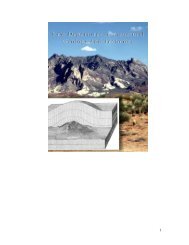
Elk Hills is located 25 km (15.5 mi) north <strong>of</strong> the bend in the San Andreas Fault<br />
(Fig. 1.1) in the southern San Joaquin Valley within the fold and thrust belt that lines<br />
the west side <strong>of</strong> the valley (Nicholson, 1990). Deformation within this belt is linked to<br />
tectonism along the San Andreas Fault, which lies just west <strong>of</strong> the Temblor Range that<br />
bounds the western limit <strong>of</strong> the valley. Coalinga, Kettleman Hills, and Lost Hills are<br />
similarly oriented antiforms proximal to Elk Hills. Interpretation <strong>of</strong> the causal tectonic<br />
mechanism for these folds has varied. In the 1970s, Wilcox et al. (1973) and Harding<br />
(1974, 1976) suggested that these echelon folds are the result <strong>of</strong> a wrenching<br />
mechanism related to slip along the San Andreas Fault. In the following decade,<br />
interpretation <strong>of</strong> a seismic reflection pr<strong>of</strong>ile across Kettleman Hills (Wentworth et al.,<br />
1984) led to the reclassification <strong>of</strong> these anticlines as thrust related. This interpretation<br />
was later strengthened by the analysis <strong>of</strong> earthquakes near New Idria in 1982 (M=5.5),<br />
Coalinga in 1983 (M=6.5) and Kettleman Hills North Dome in 1985 (M=6.1), which<br />
indicated the activity <strong>of</strong> thrust faults striking subparallel to the trend <strong>of</strong> these folds<br />
(e.g. Namson and Davis, 1988; Ekstrom et al., 1992; Stein and Ekstrom, 1992). In situ<br />
borehole studies that estimated the regional maximum horizontal compression<br />
direction as northeast-southwest (e.g. Mount and Suppe, 1987; Zoback et al., 1987;<br />
Castillo and Zoback, 1994), when combined with the northwest-southeast trend <strong>of</strong> the<br />
anticlinal hinges, are also consistent with the thrust related hypothesis.<br />
A proposition that the folds formed initially with trends oblique to the San<br />
Andreas Fault and subsequently were rotated to their subparallel orientations, with<br />
deformation style transitioning from wrench-related shearing to fault-perpendicular<br />
shortening (Miller, 1998). In this paper, we show that mechanical models do not<br />
generate representative uplift at Elk Hills when the slip along the underlying faults is<br />
4
36 0 00’<br />
Diablo Range<br />
New Idria<br />
Coalinga<br />
Coalinga<br />
120 0 00’<br />
San Andreas Fault<br />
N<br />
Kettleman Hills<br />
Temblor Range<br />
0 mile 20<br />
0 km 30<br />
120 0 00’<br />
San Joaquin<br />
Valley<br />
Lost Hills<br />
Elk Hills<br />
Buena Vista<br />
119 0 00’<br />
Taft<br />
Midway Sunset<br />
Sierra Nevada Range<br />
Bakersfield<br />
San Emigdio Mtns<br />
119 0 00’<br />
Figure 1.1. Location <strong>of</strong> the Elk Hills Oil Field within the southwestern San Joaquin<br />
Valley <strong>of</strong> California.<br />
5<br />
36 0 00’<br />
35 0 00’
predominantly strike-slip; and we present mechanical model results for the data<br />
included in this study that are consistent with a thrust fault related growth mechanism.<br />
Elk Hills Field<br />
Elk Hills was first classified as oil land based on field work by Arnold and<br />
Johnson (1910) that correlated surface morphology and lithologies at Elk Hills to that<br />
<strong>of</strong> other known oil fields in the San Joaquin Valley. Shallow tests proved the existence<br />
<strong>of</strong> oil in 1911 (Maher et al., 1975). In 1912, Elk Hills was set aside as Naval<br />
Petroleum Reserve No. 1 and remained largely shut-in until 1976 (Reid and McIntyre,<br />
2001). During this time, several geological studies, based on field data and<br />
increasingly deeper subsurface data, were conducted at Elk Hills (e.g. Thoms and<br />
Smith, 1922; Pemberton, 1929; Woodring et al., 1932; Maher et al., 1975).<br />
As a result <strong>of</strong> the multitude <strong>of</strong> wells drilled on site since the discovery <strong>of</strong> oil and<br />
field studies carried out within the greater San Joaquin Valley, the upper Tertiary<br />
stratigraphy at Elk Hills is well documented (e.g. Maher et al., 1975; Sarna-Wojcicki<br />
et al., 1979; Loomis, 1990; Sarna-Wojcicki et al., 1990; Bloch, 1992; Miller, 1999).<br />
The Monterey Formation, comprising the mid to late Miocene interval, is the best<br />
known stratigraphic sequence at Elk Hills. It has been the subject <strong>of</strong> much study in the<br />
past few decades due to its function as both source rock and reservoir for<br />
hydrocarbons, with the diagenesis <strong>of</strong> its constituent porcelanites (e.g. Graham and<br />
Williams, 1985; Eichhubl and Behl, 1998; Reid and McIntyre, 2001) and the<br />
deposition and trapping mechanisms <strong>of</strong> its constituent turbidites (e.g. MacPherson,<br />
1978; Webb, 1981; Reid, 1990; Reid, 1995; Shultz, 2003) receiving specific attention.<br />
These studies combined with investigations into the larger San Joaquin Valley<br />
petroleum system (e.g. Peters et al., 1994), have bolstered recovery efforts at Elk Hills.<br />
Today, over 2,000 wells are producing from four petroleum zones. As <strong>of</strong> 2004,<br />
cumulative production at Elk Hills exceeded 1.2 billion barrels <strong>of</strong> oil and 1.8 trillion<br />
cubic feet <strong>of</strong> natural gas, making it the seventh largest oil field in the continental U.S<br />
(California Division <strong>of</strong> Oil and Gas, 2005).<br />
6
Structural Interpretation<br />
The Elk Hills structure has an overall northwest-southeast anticlinal trend (Fig.<br />
1.2a, 1.2b). At shallow depths, Elk Hills is a broad structure with two slight highs<br />
representing left stepping echelon anticlines called 29R and 31S (Fig. 1.2a). At depth,<br />
these anticlines are distinct and a much lower amplitude fold called the Northwest<br />
Stevens structure lies to the northwest <strong>of</strong> the echelon folds (Fig. 1.2b). Collectively,<br />
these three structures constitute the Elk Hills Anticline and Oil Field.<br />
The fault interpretation at Elk Hills is based primarily upon the three-<br />
dimensional volume <strong>of</strong> seismic reflection data that was collected over the field from<br />
1999 to 2000. Along with borehole data from over 700 wells, the seismic data place<br />
constraints on the large scale faulting in the field. In the western part <strong>of</strong> the field, four<br />
main structure bounding faults have been identified, all <strong>of</strong> which strike northwest-<br />
southeast (Fig. 1.2a and 1.2b). Three <strong>of</strong> these faults, 1R, 2R, and 3R, are thrust faults<br />
with dips that decrease with depth (Fig. 1.2c). The decollement surface for the 1R fault<br />
is placed within the Late Oligocene Lower Santos shale, approximately 1 km above<br />
that inferred for the 2R and 3R faults, which sole into the Early Oligocene Tumey<br />
shale. These decollement levels are somewhat ambiguous within the seismic reflection<br />
data, and have been located with the help <strong>of</strong> mechanical models. Mechanical models<br />
have also helped to interpret the fourth fault, 5R, as a backthrust <strong>of</strong> the 1R fault.<br />
Correlating the spatial location <strong>of</strong> these faults with the shape <strong>of</strong> deformed seismic<br />
reflectors as displayed on structure contour maps, we associate the 2R fault with the<br />
Northwest Stevens anticline, the 3R fault with the 31S anticline, and the 1R and 5R<br />
faults with the 29R anticline (Fig. 1.2).<br />
Cross sections through the eastern part <strong>of</strong> the field reveal a different structural<br />
configuration (Fig. 1.2d). Here, the 7 fault is a steep and nearly planar fault dipping to<br />
the south. It trends east-west, as does the 6R fault, which dips to the north.<br />
Stratigraphic features within the seismic data imply that the 6R fault is much younger<br />
than the 7 fault (Fig. 1.2c). An anticlinal crest comparable to the anticlinal crest<br />
located slightly to the south <strong>of</strong> the 7 fault has not developed adjacent to the 6R fault at<br />
depth, suggesting that early in the structural history <strong>of</strong> Elk Hills, the 7 fault was the<br />
only fold forming fault present in the eastern part <strong>of</strong> the field. Mechanical<br />
7
SW NE<br />
S N<br />
8<br />
8<br />
0 km 2<br />
0 km 2<br />
7<br />
0 mile 1<br />
7<br />
0 mile 1<br />
6<br />
6<br />
5<br />
5<br />
depth (km) 0<br />
McDONALD<br />
3R<br />
2R<br />
1R<br />
4<br />
BASE REEF RIDGE<br />
3<br />
5R<br />
CALITROLEUM<br />
2<br />
NWS<br />
anticline<br />
WILHELM<br />
31S<br />
anticline<br />
MYA4-A<br />
1<br />
29R<br />
anticline<br />
depth (km) 0<br />
6R<br />
4<br />
McDONALD<br />
7<br />
BASEREEFRIDGE<br />
3<br />
2<br />
CALITROLEUM<br />
31S<br />
anticline<br />
WILHELM<br />
1<br />
MYA4-A<br />
(c) (d)<br />
A A’<br />
B B’<br />
NE<br />
119 0 32’00”<br />
119 0 26’00”<br />
119 0 20’00”<br />
119 0 32’00”<br />
119 0 26’00”<br />
119 0 20’00”<br />
0 km 2<br />
8<br />
B<br />
0 km 2<br />
B<br />
0mile1 6R<br />
1829<br />
305<br />
0mile 1<br />
N<br />
2438<br />
A<br />
N<br />
6R<br />
1R<br />
610<br />
A<br />
1R<br />
5R<br />
3048<br />
35 0 16’00” 35 0 20’00”<br />
914<br />
3658<br />
7<br />
5R<br />
31S anticline<br />
31S anticline<br />
29R anticline<br />
1219<br />
4267<br />
7<br />
1524<br />
29R anticline<br />
4877<br />
3R<br />
depth (m)<br />
3R<br />
depth (m)<br />
NWS anticline<br />
B’<br />
NWS anticline<br />
B’<br />
2R<br />
A’<br />
35 0 20’00”<br />
35 0 16’00” 35 0 20’00”<br />
2R<br />
A’<br />
35 0 20’00”<br />
C.I. = 76 m (250 ft)<br />
C.I. = 152 m (500 ft)<br />
(a) (b)<br />
119 0 32’00”<br />
119 0 26’00”<br />
119 0 20’00”<br />
119 0 32’00”<br />
119 0 26’00”<br />
119 0 20’00”
Figure 1.2 (opposite page). (a) Structure contour map <strong>of</strong> a Late Pliocene stratigraphic<br />
unit. The traces <strong>of</strong> the six seismically interpreted, structure bounding faults are drawn<br />
on the map and labeled. Dashed lines represent faults that are below the contoured<br />
surface. (b) Structure contour map <strong>of</strong> a Middle Miocene stratigraphic unit. At this<br />
depth, the slight highs seen in figure 1.2a, the 31S and the 29R anticlines, are clearly<br />
two distinct anticlines. A fold <strong>of</strong> much lower amplitude, the Northwest Stevens<br />
structure, lies to the north. (c) A cross section through the western part <strong>of</strong> the field<br />
running along the line A to A’ in (a) and (b). (d) A cross section through the eastern<br />
part <strong>of</strong> the field running along the line B to B’ in (a) and (b). Labeled anticlinal crests,<br />
faults, and marker horizons are the structural and stratigraphic elements factoring into<br />
this study.<br />
modeling has indicated that the 6R fault is a backthrust <strong>of</strong> the 7 fault and does not<br />
cross-cut the 7 fault.<br />
Velocity Model<br />
We created a three-dimensional velocity model to convert surfaces interpreted<br />
within the seismic data volume from the time domain to the depth domain. The three<br />
dimensionality <strong>of</strong> this model is very important to the preservation <strong>of</strong> the shapes <strong>of</strong> the<br />
faults as they are interpreted, and these shapes provide the input geometry for the<br />
mechanical models. As noted, the majority <strong>of</strong> faults at Elk Hills are not planar. Thus,<br />
the two-dimensional method, commonly applied within fields where planar faults<br />
exist, <strong>of</strong> converting fault polygons (hanging wall and footwall cuts) from time to depth<br />
at various horizons and then extending a planar surface between these polygons to<br />
generate a three-dimensional fault surface, is not adequate for the Elk Hills field.<br />
The velocity model was calibrated with the Base Reef Ridge horizon (see<br />
below). This horizon was selected as a calibration surface based primarily on the<br />
exceptional well control <strong>of</strong> 704 data points. It was chosen over other surfaces <strong>of</strong><br />
comparable well control due to its position lower in the stratigraphic column, thus<br />
providing calibration to deeper levels. The velocities within the model range from<br />
1,400 m/sec (4,600 ft/sec) near the surface to 6,000 m/sec (19,700 ft/sec) at depth.<br />
This velocity pr<strong>of</strong>ile corresponds to the two-way travel time interval extending from 0<br />
to 5 seconds, the lower limit <strong>of</strong> the seismic volume.<br />
9
Stratigraphy<br />
Five stratigraphic markers were selected for use in this study: the Middle<br />
Miocene McDonald horizon, the Early Pliocene Base Reef Ridge horizon (BRR), the<br />
Early Pliocene Calitroleum horizon, the Middle Pliocene Wilhelm horizon, and the<br />
Late Pliocene Mya 4-A horizon (Fig. 1.3). Due to strong seismic reflections (large<br />
impedance contrasts), each horizon can be correlated throughout the three-dimensional<br />
volume. Well picks, numbering into the hundreds for each <strong>of</strong> these horizons, serve as<br />
calibration for the geophysical seismic reflection volume. No horizons older than the<br />
mid Miocene McDonald horizon are included in this study because both well control<br />
and clarity <strong>of</strong> the seismic reflection imaging diminish greatly below the McDonald<br />
marker. The results <strong>of</strong> this study therefore have implications for the development <strong>of</strong><br />
Elk Hills during the time period extending from the Middle Miocene to the present.<br />
Stratigraphic constraints<br />
Stratigraphic analyses contribute significantly to the interpretation <strong>of</strong> fault<br />
evolution at Elk Hills because the faulting is syn-depositional growth faulting. As<br />
evident in cross sectional views (Fig. 1.2c and 1.2d), stratigraphic intervals thin<br />
toward faults within their hanging wall and thicken discontinuously across the fault<br />
planes into the footwall. These and similar stratigraphic features can be identified and<br />
used to interpret the timing <strong>of</strong> relative motion. These techniques provide sufficient<br />
constraints on fault evolution so particular fault initiations can be bracketed between<br />
the deposition times <strong>of</strong> different stratigraphic layers.<br />
Pseudowells<br />
We term the first method <strong>of</strong> stratigraphic analysis pseudowells because they are<br />
artificial pr<strong>of</strong>iles <strong>of</strong> interval thicknesses. To construct pseudowells, we generated<br />
depth converted cross-sections running perpendicular to the strike <strong>of</strong> the faults. We<br />
then drew two well-path trajectories for each fault, one in the hanging wall and the<br />
other in the footwall, both parallel to and equidistant from the fault (Fig. 1.4a). Where<br />
a trajectory intersects with the center <strong>of</strong> an interval, a bedding perpendicular<br />
10
PERIOD<br />
QUAT.<br />
NEOGENE<br />
PALEOGENE<br />
EPOCH<br />
PLEIST.<br />
PLIOCENE<br />
MIOCENE<br />
OLIGOCENE<br />
EOCENE<br />
FORMATION MEMBER / ZONE<br />
SAN JOAQUIN<br />
ETCHEGOIN<br />
MONTEREY<br />
TEMBLOR<br />
sandstone<br />
pebbly sand<br />
clay shale<br />
silty shale<br />
TULARE<br />
DRY GAS ZONE<br />
SHALLOW OIL ZONE<br />
REEF RIDGE<br />
ANTELOPE SHALE /<br />
MCDONALD<br />
DEVILWATER / GOULD<br />
MEDIA<br />
CARNEROS<br />
UPPER SANTOS<br />
CASTLEROCK<br />
LOWER SANTOS<br />
SALT CREEK / CYMRIC<br />
OCEANIC<br />
TUMEY<br />
STEVENS<br />
PHACOIDES<br />
KREYENHAGEN<br />
siliceous shale<br />
dolomitic shale<br />
LITH.<br />
interbedded sandstone<br />
and siltstone<br />
sandstone lens<br />
Mya 4-A<br />
Wilhelm<br />
Calitroleum<br />
Base Reef<br />
Ridge<br />
(BRR)<br />
McDonald<br />
Figure 1.3. Stratigraphic column <strong>of</strong> the mid to upper tertiary sediments at Elk Hills<br />
based on Maher et al. (1975). The stratigraphic positions <strong>of</strong> the five markers used in<br />
this study are noted to the right <strong>of</strong> the column. The lithology column is highly<br />
simplified.<br />
11
thickness was measured and plotted. The thickness <strong>of</strong> each interval is hung on the top<br />
horizon <strong>of</strong> that interval (Fig. 1.4b). Because the strike <strong>of</strong> the faults in the eastern part<br />
<strong>of</strong> the Elk Hills field is much different from that in the western part, we consider these<br />
parts separately.<br />
Pseudowell interpretation relied heavily upon cross-sections. For instance, the<br />
cross section in figure 1.4a shows a regional thickening <strong>of</strong> sediments toward the<br />
southwest during McDonald to BRR time <strong>of</strong> depostion. For the other three time<br />
intervals considered, the regional thickening direction is reversed, with thickening<br />
toward the northeast. When looking at the pseudowell plot (Fig. 1.4b), we note<br />
interruptions in the regional trends. Fault activity is identified based on both<br />
stratigraphic thinning and sharp changes in thickness across faults. An anomalously<br />
thin interval is correlated with the location <strong>of</strong> a structural high, where thinning is<br />
interpreted as the result <strong>of</strong> erosion (or lesser deposition) <strong>of</strong> sediments caused by uplift<br />
associated with slip on the underlying fault. Eroded sediments from the uplifted<br />
hanging walls are subsequently deposited on the footwalls, creating a difference in<br />
thickness <strong>of</strong> the interval from one side <strong>of</strong> the fault to the other.<br />
Pseudowell interpretations: Western Elk Hills<br />
Figure 1.4b shows that during the period from McDonald to BRR time, there is a<br />
departure from the trend <strong>of</strong> thickening toward the southwest at pseudowells H2R and<br />
H3R. These pseudowells are positioned in the hanging walls <strong>of</strong> the 2R and 3R faults,<br />
respectively. The cross section in figure 1.4a shows a change in thickness across the<br />
2R fault and a larger change across the 3R fault, suggesting that both faults were<br />
active during this interval. The thickness <strong>of</strong> the McDonald to BRR interval in figure<br />
1.4a is slightly different across the 1R fault. We tentatively infer that 1R was less<br />
active (or inactive) during this time relative to 2R and 3R, but reexamine this activity<br />
more closely in subsequent examples. There is no thinning <strong>of</strong> the McDonald to BRR<br />
interval in the 29R anticline during this time, and the hanging wall and footwall<br />
thicknesses across the 5R fault are constant, indicating that the 5R fault was inactive.<br />
12
(a)<br />
depth (km)<br />
0<br />
1<br />
2<br />
3<br />
4<br />
5<br />
6<br />
7<br />
8<br />
(c)<br />
1<br />
2<br />
3<br />
4<br />
5<br />
depth (km) 0<br />
6<br />
7<br />
8<br />
0 mile 1<br />
0 km 2<br />
SW NE<br />
H6R<br />
F6R<br />
0 mile 1<br />
0 km 2<br />
F5R H5R<br />
1R<br />
31S<br />
anticline<br />
6R<br />
29R<br />
anticline<br />
7<br />
5R<br />
H1R F1R H3R F3R<br />
3R<br />
H7 F7<br />
31S<br />
anticline<br />
2R<br />
NWS<br />
anticline<br />
MYA4- A<br />
S N<br />
H2R F2R<br />
NE<br />
MYA4-A<br />
(b)<br />
(d)<br />
m<br />
0<br />
400<br />
0<br />
400<br />
800<br />
0<br />
400<br />
800<br />
1200<br />
0<br />
400<br />
800<br />
F5R H5R H1R F1R H3R F3R H2R F2R<br />
MYA4-A<br />
WILHELM<br />
CALITROLEUM<br />
BRR<br />
1200<br />
SW NE<br />
m<br />
0<br />
400<br />
0<br />
400<br />
0<br />
400<br />
0<br />
400<br />
800<br />
F6R H6R H7 F7<br />
MYA4-A<br />
WILHELM<br />
CALITROLEUM<br />
BRR<br />
S N<br />
Figure 1.4. Cross sections through the (a) western and (c) eastern parts <strong>of</strong> the field<br />
showing the locations <strong>of</strong> pseudowells used for stratigraphic analysis. The orientation<br />
<strong>of</strong> the cross sections run from A to A’ and B to B’ in figure 1.2a. Dashed gray lines<br />
represent pseudowell paths and white dots represent the intersection points <strong>of</strong> these<br />
wellpaths with the centers <strong>of</strong> stratigraphic intervals. White lines represent the bedding<br />
perpendicular thickness measurements made for each interval along wellpaths.<br />
Pseudowell plot <strong>of</strong> the thicknesses in meters <strong>of</strong> the four stratigraphic intervals in each<br />
well location for the (b) western and (d) eastern parts <strong>of</strong> the field.<br />
13
The most notable feature in the interval from BRR to Calitroleum time is the<br />
large contrast in hanging wall and footwall thickness across the 2R fault (Fig. 1.4a).<br />
This observation is mirrored in the pseudowell plot at well F2R, where the thickness is<br />
much greater than in well H2R, departing from the slight thickening trend. We infer<br />
that the 2R fault was very active during this period. Similarly, this interval in well<br />
H3R in the hanging wall <strong>of</strong> the 3R fault is thin compared to that in well F3R in the<br />
footwall, suggesting continued slip along 3R. Little can be deduced about the activity<br />
<strong>of</strong> the 1R fault from these plots. As in the earlier interval, the hanging wall and<br />
footwall thicknesses across the 5R fault are constant, suggesting that no slip occurred<br />
from BRR to Calitroleum time.<br />
The Calitroleum to Wilhelm interval is thin in pseudowell H5R compared to<br />
both F5R and H1R (Fig. 1.4b). This suggests that the area near H5R was a structural<br />
high, and implies the presence <strong>of</strong> an active fault beneath the interval. Slip along either<br />
or both the 1R and 5R faults could produce uplift at H5R. A disparity in the<br />
thicknesses <strong>of</strong> the Calitroleum to Wilhelm interval between the hanging wall and<br />
footwall <strong>of</strong> the 5R fault indicates that it was active during this period. It is not possible<br />
to determine from the cross section and pseudowell plots (Fig. 1.4) how large a role, if<br />
any, fault 1R played in the development <strong>of</strong> the structural high near well H5R. There is<br />
no diagnostic evidence for slip on the 2R fault from Calitroleum to Wilhelm time<br />
based on figure 1.5.<br />
In the final interval, Wilhelm to Mya 4-A, the structure was apparently<br />
composed <strong>of</strong> a single broad anticline. The pseudowells on the flanks <strong>of</strong> the structure,<br />
wells F5R, H2R, and F2R, are thick compared with other wells. Based on the thin<br />
intervals in the H1R, F1R, and F3R pseudowells, we deduce that uplift was still<br />
occurring due to slip on faults in both the northeast and the southwest parts <strong>of</strong> the<br />
field.<br />
Through this analysis, we recognize that slip along the northeastern faults, 2R<br />
and 3R, affected depositional patterns during the Late Miocene, whereas Pliocene<br />
depositional patterns suggest slip along all <strong>of</strong> the major faults. We conclude that slip<br />
along the 2R and 3R faults initiated before slip along the 1R and 5R faults, but that<br />
motion along the earlier faults continued as slip along the 1R and 5R faults initiated.<br />
14
Pseudowell interpretations: Eastern Elk Hills<br />
The most interesting stratigraphic constraints on faulting in the eastern part <strong>of</strong><br />
the Elk Hills Oil Field pertain to the 7 fault and can be seen in both cross-section (Fig.<br />
1.4c) and pseudowell analysis (Fig. 1.4d). The differences in interval thickness across<br />
the 7 fault from well H7 to well F7, as well as the differences in interval thickness<br />
across the anticline from well H7 to well H6R, indicate that activity along the 7 fault<br />
decreased after the deposition <strong>of</strong> the Base Reef Ridge to Calitroleum interval.<br />
Pseudowell analysis indicates that wells located in the hanging wall and footwall <strong>of</strong><br />
the 6R fault, wells H6R and F6R, have equivalent thickness for each <strong>of</strong> the studied<br />
intervals. The 6R fault was not active during these intervals.<br />
Bedding relationships<br />
The second technique for constraining fault timing is the examination <strong>of</strong><br />
stratigraphic bedding relationships that are indicators <strong>of</strong> fault movement. Figure 1.5<br />
provides schematic drawings <strong>of</strong> the five relationships considered: divergent fill,<br />
disrupted reflectors, onlap fill, divergent reflectors, and disrupted fill (Mitchum et al.,<br />
1977). Interpretation <strong>of</strong> these relationships is based upon the interaction <strong>of</strong> structure<br />
and stratigraphy. Divergent fill indicates syn-faulting strata, disrupted reflectors<br />
indicate pre-faulting strata, onlap fill indicates post-faulting strata, divergent reflectors<br />
indicate syn- to post-faulting strata, and disrupted fill indicates syn-faulting strata<br />
relative to one fault and pre-faulting strata relative to the second fault. Many such<br />
bedding relationships are imaged within the Elk Hills seismic reflection dataset and<br />
these provide important constraints on fault activity (Fig. 1.6).<br />
Bedding relationship interpretations<br />
Divergent fill is shown in figure 1.6, where beds thin onto, and truncate against,<br />
the anticlinal crest in the hanging wall <strong>of</strong> the 3R fault within the McDonald to BRR<br />
interval. The 3R fault was thus active during the deposition <strong>of</strong> this interval. The 1R<br />
fault <strong>of</strong>fsets this same stratigraphic package with no apparent across fault thickness<br />
change. Consideration <strong>of</strong> the kinematics involved in the process <strong>of</strong> <strong>of</strong>fsetting divergent<br />
15
(a) (d)<br />
(b)<br />
(c)<br />
(e)<br />
2 1<br />
Figure 1.5. The five stratigraphic bedding relationships considered in this study. Each<br />
suggests a timing relationship between faulting and the deposition <strong>of</strong> sediments. (a)<br />
Divergent fill indicating syn-faulting strata. (b) Disrupted reflectors <strong>of</strong> equal thickness<br />
indicating pre-faulting strata. (c) Onlap fill indicating post faulting strata. (d) Divergent<br />
reflectors indicating syn-faulting to post faulting strata. (e) Disrupted fill indicating that<br />
the strata are syn-faulting relative to fault 1 and pre-faulting relative to fault 2<br />
(Mitchum et al., 1977). This figure also suggests a timing relationship between the<br />
two faults, with fault 1 being older than fault 2.<br />
16
fill leads to the following conclusions: (1) the 3R fault is older than the 1R fault; (2)<br />
stratigraphic layers above the base <strong>of</strong> the divergent fill post-date the initiation <strong>of</strong> slip<br />
along the 3R fault; (3) the entire divergent fill package is older than slip along the 1R<br />
fault that <strong>of</strong>fsets it.<br />
Onlap fill and divergent reflectors are seen in figure 1.6 as sags in the BRR,<br />
Calitroleum, and Wilhelm horizons above the 1R fault. These features reflect a<br />
slowing or termination <strong>of</strong> slip along the 1R fault at the time <strong>of</strong> deposition <strong>of</strong> the<br />
deformed horizons. Just above the Wilhelm horizon, however, the next resolvable<br />
reflector is fairly straight, with no kink above the 1R fault. This geometry leads to the<br />
deduction that 1R fault activity slowed after the deposition <strong>of</strong> the Wilhelm horizon.<br />
The interval <strong>of</strong> rock between the bent and straight reflectors consists <strong>of</strong> post faulting<br />
strata that leveled out the paleotopography that was generated by previous slip along<br />
the 1R fault.<br />
At the northeast end <strong>of</strong> the cross section shown in figure 1.6, divergent<br />
reflectors are labeled above the 2R fault. These reflectors document an incremental<br />
infilling <strong>of</strong> paleotopography. Reflectors one through four are sequentially less<br />
divergent, indicating that each layer was subjected to less deformation subsequent to<br />
its deposition than the previous layer. The degree to which these reflectors are<br />
divergent indicates that slip along the 2R fault slowed during Calitroleum to Wilhelm<br />
time and may have ceased shortly after Wilhelm time.<br />
Disrupted reflectors <strong>of</strong> equal thickness occur across the 5R fault just above the<br />
Calitroleum horizon. Because there is no discrepancy in the thickness <strong>of</strong> hanging wall<br />
and footwall beds, it is inferred that movement along the 5R fault postdates the<br />
deposition <strong>of</strong> the Calitroleum horizon.<br />
Isochores<br />
The final technique for stratigraphic analysis constrains both fault height and the<br />
timing between deposition and faulting using isochore maps that provide contours <strong>of</strong><br />
the vertical thickness <strong>of</strong> a given interval. We have removed overthickening effects due<br />
to repeated sections across thrust faults from the isochore maps. Four isochore maps<br />
17
two-way time (s)<br />
1.0<br />
2.0<br />
3.0<br />
4.0<br />
5R<br />
29R<br />
anticline<br />
onlap fill<br />
1R<br />
divergent fill<br />
0 mile 1<br />
31S<br />
anticline<br />
0 km 2<br />
3R<br />
2R<br />
1<br />
4<br />
3<br />
2<br />
divergent<br />
reflectors<br />
SW NE<br />
Figure 1.6. Line drawing <strong>of</strong> a seismic line exhibiting each <strong>of</strong> the stratigraphic bedding<br />
relationships shown in figure 1.5. Timing relationships can be deduced from analysis<br />
<strong>of</strong> these indicators.<br />
18<br />
1<br />
2<br />
3<br />
4<br />
5<br />
approximate depth (km)
were interpreted, representing each <strong>of</strong> the studied time intervals (Fig. 1.7a, 1.7c, 1.7e,<br />
1.7g). In analyzing these maps, we focused on two fault-related signatures, contour<br />
merging and bed thinning. Closely spaced and merging contours (Fig. 1.8a) may<br />
indicate that a fault cut the interval at the time <strong>of</strong> deposition (Fig. 1.8b). Sediments<br />
eroded <strong>of</strong>f the hanging wall may be deposited on the footwall side <strong>of</strong> the fault,<br />
resulting in a sharp thickness contrast across the fault. The thinning <strong>of</strong> beds may<br />
indicate a structural high (Fig. 1.8c). Isochore maps do not contain information about<br />
the relative depths <strong>of</strong> any two points within a layer. Thus, thinning intervals could<br />
result from syn-depositional faulting below the interval, so the beds <strong>of</strong> interest are<br />
uplifted (Fig. 1.8di), or post-tectonic infilling by sediments <strong>of</strong> paleotopography (Fig.<br />
1.8dii). We use the seismic character <strong>of</strong> divergent reflectors, as previously illustrated<br />
in figure 1.6, to determine which interpretation is more representative <strong>of</strong> the faulting in<br />
question.<br />
Isochore interpretations: McDonald to Base Reef Ridge<br />
Isochores <strong>of</strong> vertical thickness between the McDonald and the Base Reef Ridge<br />
markers (Fig. 1.7a) show that a structural high is present along the trace <strong>of</strong> the 2R<br />
fault, indicating an active fault beneath the interval at the time <strong>of</strong> deposition. The<br />
structural high and close contours along the trace <strong>of</strong> the 3R fault indicate that it cut the<br />
interval during the time <strong>of</strong> deposition. Both <strong>of</strong> these faults were previously determined<br />
to be active prior to McDonald deposition, based on fault movement indicators.<br />
Isochore interpretation presents an additional conclusion in terms <strong>of</strong> the relative ages<br />
<strong>of</strong> these faults. Because the 3R fault cut further up section than the 2R fault during this<br />
time interval and the two faults sole to the same decollement level (Fig. 1.2b and<br />
1.4a), we infer that the 3R fault is older than the 2R fault.<br />
A few small isolated structural highs exist along the trace <strong>of</strong> the 1R fault,<br />
indicating that it was not slipping along its entire present day length. We infer that this<br />
isochore map captures the very early stages <strong>of</strong> growth <strong>of</strong> the 1R fault. Because the<br />
thickness <strong>of</strong> the McDonald to BRR interval remains roughly constant across the<br />
location <strong>of</strong> the trace <strong>of</strong> the 5R fault, we infer that the 5R fault was inactive during this<br />
time interval.<br />
19
(a)<br />
35 0 16’00” 35 0 20’00”<br />
(c)<br />
35 0 16’00” 35 0 20’00”<br />
(e)<br />
35 0 16’00” 35 0 20’00”<br />
(g)<br />
35 0 16’00” 35 0 20’00”<br />
N<br />
0mile1 0 km 2<br />
N<br />
0mile1 0 km 2<br />
N<br />
0mile1 0 km 2<br />
N<br />
0mile1 0 km 2<br />
119 0 32’00”<br />
2R<br />
2R<br />
2R<br />
2R<br />
119 0 32’00”<br />
5R<br />
5R<br />
5R<br />
5R<br />
3R<br />
1R<br />
119 0 26’00”<br />
3R<br />
1R<br />
1R<br />
3R<br />
3R<br />
1R<br />
119 0 26’00”<br />
C.I. = 76 m (250 ft)<br />
7<br />
6R<br />
119 0 20’00”<br />
C.I. = 76 m (250 ft)<br />
7<br />
C.I. = 15 m (50 ft)<br />
7<br />
6R<br />
6R<br />
C.I. = 15 m (50 ft)<br />
7<br />
6R<br />
119 0 20’00”<br />
35 0 20’00”<br />
thickness<br />
(m)<br />
1524<br />
1219<br />
914<br />
610<br />
305<br />
35 0 20’00” thickness<br />
(m)<br />
35 0 20’00”<br />
thickness<br />
(m)<br />
35 0 20’00”<br />
1829<br />
1524<br />
1219<br />
914<br />
610<br />
305<br />
427<br />
366<br />
305<br />
244<br />
183<br />
122<br />
thickness<br />
(m)<br />
366<br />
305<br />
244<br />
183<br />
122<br />
(b)<br />
35 0 16’00” 35 0 20’00”<br />
(d)<br />
35 0 16’00” 35 0 20’00”<br />
(f)<br />
35 0 16’00” 35 0 20’00”<br />
(h)<br />
35 0 16’00” 35 0 20’00”<br />
20<br />
119 0 32’00”<br />
119 0 32’00”<br />
119 0 32’00”<br />
119 0 32’00”<br />
119 0 26’00”<br />
119 0 26’00”<br />
119 0 26’00”<br />
119 0 26’00”<br />
119 0 20’00”<br />
N<br />
0 km 2<br />
119 0 20’00”<br />
N<br />
0 km 2<br />
119 0 20’00”<br />
N<br />
0 km 2<br />
119 0 20’00”<br />
N<br />
0 km 2<br />
35 0 20’00”<br />
35 0 20’00”<br />
35 0 20’00”<br />
35 0 20’00”<br />
1<br />
0.95<br />
0.9<br />
0.85<br />
0.8<br />
0.75<br />
0.7<br />
0.65<br />
0.6<br />
0.55<br />
1<br />
0.95<br />
0.9<br />
0.85<br />
0.8<br />
0.75<br />
0.7<br />
0.65<br />
0.6<br />
1<br />
0.95<br />
0.9<br />
0.85<br />
0.8<br />
0.75<br />
0.7<br />
1<br />
0.95<br />
0.9<br />
0.85<br />
0.8<br />
0.75<br />
0.7<br />
normalized thickness normalized thickness normalized thickness normalized thickness
Figure 1.7 (opposite page). Isochore maps <strong>of</strong> the intervals: McDonald to Base Reef<br />
Ridge (a) as interpreted, (b) as modeled; Base Reef Ridge to Calitroleum (c) as<br />
interpreted, (d) as modeled; Calitroleum to Wilhelm, (e) as interpreted, (f) as modeled;<br />
Wilhelm to Mya 4-A (g) as interpreted, (h) as modeled. Fault traces have been plotted<br />
and labeled on the interpreted isochore maps with solid lines representing faults that<br />
cut through the interval at the time <strong>of</strong> deposition, dashed lines representing faults that<br />
were below the interval at the time <strong>of</strong> deposition, and dotted line representing faults<br />
that had not yet begun to slip at the time <strong>of</strong> deposition <strong>of</strong> the interval. The thickness<br />
colorbar and contours for the interpreted isochores have been converted from feet<br />
into meters. Modeled isochores show normalized thicknesses with a 0.1 contour<br />
interval. For location referencing, an index map outlining the production blocks <strong>of</strong> the<br />
field has been plotted on both interpreted and modeled isochore maps.<br />
In the eastern part <strong>of</strong> the field, the structural high and close contours along the<br />
trace <strong>of</strong> the 7 fault indicate that it was active and cut up through the McDonald to Base<br />
Reef Ridge interval during the time <strong>of</strong> its deposition. Further to the south, along the<br />
present day trace <strong>of</strong> the 6R fault, there is no evidence <strong>of</strong> fault activity. The 6R fault<br />
trace lays in a low that is most likely an expression <strong>of</strong> the hanging wall subsidence that<br />
occurs well behind the tipline <strong>of</strong> a thrust fault as a result <strong>of</strong> displacement <strong>of</strong> material<br />
up the fault plane (Savage and Cooke, 2004).<br />
Isochore interpretations: Base Reef Ridge to Calitroleum<br />
The isochore map representing the time interval from Base Reef Ridge to<br />
Calitroleum deposition (Fig. 1.7b), highlights a few changes in fault activity from the<br />
previous interval. The very close contours and large difference in contour values<br />
across the 2R fault (about 1000 feet), indicate that this fault was active and cut up<br />
through the section, uplifting Base Reef Ridge to Calitroleum sediments in the<br />
hanging wall, much <strong>of</strong> which were eroded <strong>of</strong>f to create the large disparity in thickness<br />
<strong>of</strong> this interval across the 2R fault. The 3R fault apparently was still active during this<br />
interval based on the adjacent structural high, and the fact that it cut through this<br />
interval. If we compare the extent <strong>of</strong> the expression <strong>of</strong> the 3R fault in the Base Reef<br />
Ridge to Calitroleum interval with the previous interval, we see that slip migrated<br />
toward the southeastern end <strong>of</strong> the fault, which cuts through the interval, as indicated<br />
by the pattern <strong>of</strong> thinning across the crest <strong>of</strong> the 31S anticline. The east-west portion<br />
<strong>of</strong> the 31S anticline is thin during this interval, indicating that uplift along the 7 fault<br />
21
Figure 1.8. Fault related signatures seen within isochore maps. (a) Close contours<br />
are indicative <strong>of</strong> a fault cutting the interval during deposition. (b) A cross sectional<br />
view through the anticline along line C to C’ shown in (a). (c) Thin beds are indicative<br />
<strong>of</strong> a structural high. The line D to D’ shows the location <strong>of</strong> a cross-section through the<br />
anticline that can have two possible configurations: (di) thinning beds can result from<br />
an active fault beneath the interval, causing syn-depositional uplift, (dii) thinning beds<br />
can result from infill <strong>of</strong> paleotopography after fault slip.<br />
22
continued into Base Reef Ridge to Calitroleum time. In contrast with the previous<br />
interval, however, there is not a jump in the contour values along the trace <strong>of</strong> the fault,<br />
so it did not cut through the interval. The highly asymmetric shape <strong>of</strong> the thinning<br />
pattern, with a much steeper gradient on the northern side <strong>of</strong> the structural high,<br />
suggests that the sediments <strong>of</strong> this interval were draped over the tip <strong>of</strong> an active fault.<br />
To the south, in the vicinity <strong>of</strong> the 6R fault trace, the absence <strong>of</strong> a structural high, and<br />
<strong>of</strong> close contours, reveal that the fault had not yet developed at the time the<br />
Calitroleum was deposited.<br />
During this interval, the 1R fault was slipping along the entire length <strong>of</strong> the<br />
present day fault, as indicated by the extent <strong>of</strong> the structural high. To the southwest <strong>of</strong><br />
this structural high, where the thickness <strong>of</strong> the interval is fairly constant, there are no<br />
signs <strong>of</strong> activity along the 5R fault. We interpret the structural highs to the southeast<br />
<strong>of</strong> the 29R anticline as being related to uplift along faults associated with the Buena<br />
Vista and Midway-Sunset fields (Fig. 1.1).<br />
Isochore interpretations: Calitroleum to Wilhelm<br />
Isochore thickness patterns and fault activity change drastically after Calitroleum<br />
time. In the Calitroleum to Wilhelm isochore map (Fig. 1.7c), there is little<br />
disturbance <strong>of</strong> contours in the area <strong>of</strong> the 2R fault. During this interval, the 2R fault<br />
slipped much less than in the previous time interval, if at all. Similarly, slip along the 7<br />
fault virtually shut <strong>of</strong>f, as the average strike <strong>of</strong> the 31S anticline in this isochore map is<br />
oriented more northwest-southeast than previously, with the east-west section not as<br />
well-defined. The 3R fault was still active from Calitroleum to Wilhelm time, as the<br />
northwest-southeast part <strong>of</strong> the 31S anticline remained thin. In the southwestern part<br />
<strong>of</strong> the study area, a northwest-southeast striking depression bounded on the northeast<br />
by close contours appears along the trace <strong>of</strong> the 5R fault. This marks the beginning <strong>of</strong><br />
slip along the 5R fault and expresses the uplift and erosion <strong>of</strong> hanging wall sediments.<br />
Judging from the pattern <strong>of</strong> thinning over the 29R structure, where the gradient along<br />
the northern limb is steep, the 1R fault also was active during the Calitroleum to<br />
Wilhelm interval.<br />
23
Isochore interpretations: Wilhelm to Mya 4-A<br />
The isochore map (Fig. 1.7d) <strong>of</strong> the time from Wilhelm deposition to Mya 4-A<br />
deposition, depicts a relatively thin stratigraphic interval. The difference between the<br />
thickest and thinnest sections is small, and thus the contour map appears very noisy<br />
and is more difficult to interpret, but trends are noticeable. The 31S and 29R anticline<br />
locations remain thin through this time period, indicating that the 3R, 1R, and 5R<br />
faults were still active. As in the previous interval, little evidence for motion along the<br />
2R fault exists. Examination <strong>of</strong> the southern part <strong>of</strong> the isochore map indicates that the<br />
5R fault remained active beneath the interval while the 6R fault had not yet begun to<br />
slip.<br />
Stratigraphic Constraints on Fault Evolution<br />
The pseudowell, bedding relationship, and isochore interpretations made at Elk<br />
Hills allow us to place constraints on the evolution <strong>of</strong> the fault system beneath the<br />
anticline (Fig. 1.9). These stratigraphic interpretations indicate that in the western part<br />
<strong>of</strong> Elk Hills, both the 2R and 3R faults were active prior to deposition <strong>of</strong> the<br />
McDonald horizon. Initiation <strong>of</strong> slip along isolated segments <strong>of</strong> the 1R fault occurred<br />
at some time after McDonald deposition, but before Base Reef Ridge deposition and<br />
the 1R fault began slipping as a whole after Base Reef Ridge deposition. The 5R fault<br />
formed during the interval between Calitroleum and Wilhelm deposition.<br />
Interpretations for the eastern part <strong>of</strong> the field indicate that the 7 fault was active prior<br />
to McDonald deposition and slowed greatly after Calitroleum deposition and that the<br />
6R fault formed very late in the evolution <strong>of</strong> the anticline.<br />
Mechanical Modeling<br />
To test the mechanical viability <strong>of</strong> the stratigraphically interpreted fault<br />
chronology, and to further refine the evolution (both timing and geometry) <strong>of</strong> the fault<br />
network at Elk Hills, we turn to forward numerical models. The remainder <strong>of</strong> this<br />
paper focuses on the method involved in developing a mechanical model to apply to<br />
growth faulting. We do not show the results <strong>of</strong> all the scenarios tested, but only the<br />
model that provided the best fit for the data at Elk Hills. From this model, we<br />
24
(a)<br />
A A’<br />
3R<br />
pre-McDonald<br />
(Middle Miocene)<br />
A A‘<br />
A A‘<br />
1R<br />
5R<br />
3R<br />
2R<br />
pre-Base Reef Ridge<br />
(Early Pliocene)<br />
A A‘<br />
1R<br />
3R<br />
3R<br />
2R<br />
pre-McDonald<br />
(Middle Miocene)<br />
2R<br />
pre-Wilhlem<br />
(Middle Pliocene)<br />
(b)<br />
B B’<br />
7<br />
pre-McDonald<br />
(Middle Miocene)<br />
B B’<br />
6R<br />
7<br />
post Mya-4A<br />
(Late Pliocene)<br />
Figure 1.9. Conceptual model <strong>of</strong> fault evolution in (a) the western part and (b) the<br />
eastern part <strong>of</strong> the Elk Hills oil field. Each box represents a distinct stage in the<br />
faulting history in which a new fault, shown in black, begins to slip. Faults shown in<br />
gray have been active during a prior stage <strong>of</strong> evolution. These schematic fault crosssections<br />
are located along lines A to A’ and B to B’ in figures 1.2a and 1.2b.<br />
25
determined: (1) the 6R fault formed as a backthrust <strong>of</strong> the 7 fault sometime after Mya<br />
4-A deposition; (2) the 5R fault is a backthrust <strong>of</strong> the 1R fault; (3) the 1R fault has a<br />
different decollement surface than the 2R and 3R faults, which sole at a deeper<br />
stratigraphic level; and (4) <strong>of</strong> the major faults included in this study, only the 7 and 2R<br />
faults are inactive today. For all <strong>of</strong> the remaining faults, additional increments <strong>of</strong> slip<br />
accumulated in each successive stage <strong>of</strong> deformation once the fault initiated.<br />
For the mechanical modeling involved in this study, we use Poly3D (Thomas,<br />
1993), a boundary element computer program based on the deformation <strong>of</strong> a linear<br />
elastic, homogeneous, and isotropic solid. It is a three-dimensional displacement<br />
discontinuity program that solves for the elastic stress, strain, and displacement fields<br />
resulting from fault slip. Complex fault geometries can be investigated because the<br />
program models faults as assemblages <strong>of</strong> triangular elements <strong>of</strong> displacecment<br />
discontinuity. Each element is constructed by the superposition <strong>of</strong> angular dislocations<br />
(Comninou and Dunders, 1975; Jeyakumaran et al., 1992). Previous investigators have<br />
documented agreement between numerical approximations resulting from Poly3D and<br />
related analytical solutions (Thomas, 1993; Willemse et al., 1996; Crider and Pollard,<br />
1998); thus validating the reliability <strong>of</strong> the code.<br />
Our hypothesis for Elk Hills is that the faults are first order heterogeneities and<br />
that heterogeneity in mechanical properties <strong>of</strong> the stratigraphic layering contributed to<br />
a lesser degree to the shape <strong>of</strong> the folds. Dealing with a homogeneous model space<br />
allows us to investigate deformation related to fault heterogeneity in an otherwise<br />
simple and well-constrained setting. We show that significant insight can be gained<br />
from this approach which has the advantage <strong>of</strong> being more efficient to implement than<br />
approaches that could address the material heterogeneities.<br />
Boundary Conditions<br />
Local boundary conditions are specified on each triangular element as three<br />
components <strong>of</strong> a uniform displacement discontinuity or <strong>of</strong> the traction at the midpoint.<br />
We prescribe local zero traction in the strike and dip directions and zero displacement<br />
discontinuity in the direction perpendicular to the elements. These conditions allow<br />
26
the two surfaces <strong>of</strong> each element to slip freely in a strike-slip and dip-slip sense, but<br />
restrict the element surfaces from opening or interpenetrating.<br />
We consider several different remote (tectonic) strain boundary conditions,<br />
depicted in the insets in figures 1.10a – 1.10f, and observe how points along an<br />
originally flat observation grid are displaced as the Elk Hills faults respond to the<br />
remote loading. For this analysis <strong>of</strong> the remote boundary conditions, we simplify the<br />
model to the application <strong>of</strong> one strain step to build a basic intuition as to how variation<br />
in remote strain direction affects the deformation. We observe the pattern <strong>of</strong> uplift,<br />
noting where it has the same general trends as those seen in the interpreted structure<br />
contour maps (e.g. Fig. 1.2a). The following discussion examines these correlations<br />
for each <strong>of</strong> the boundary conditions. We disregard slip along the 6R fault because<br />
stratigraphic analysis has shown it to be very recent.<br />
The first loading condition tests whether slip along the San Andreas Fault could<br />
be wholly responsible for the deformation at Elk Hills. We specify a zero remote stress<br />
field and apply a right lateral displacement discontinuity <strong>of</strong> 33 mm, representing the<br />
slip accrued in one year (Toda and Stein, 2002), on a model San Andreas Fault that<br />
extends to 1000 km depth. The use <strong>of</strong> this deep dislocation is based on studies <strong>of</strong><br />
transform plate boundaries using GPS data that indicate such a dislocation embedded<br />
in an elastic half-space produces a displacement field at the free surface that is<br />
comparable with the measured displacement field (e.g. Savage, 1990; Muller et al.,<br />
2003). The uplift pattern mapped within the seismic volume (Fig. 1.2a) is not similar<br />
to the computed displacement field (Fig. 1.10a), so we conclude that slip on the plate<br />
boundary is unlikely to generate the Elk Hills uplift.<br />
In an Elk Hills structural overview paper, Nicholson (1990) suggested that the<br />
slip <strong>of</strong> the Elk Hills faults that generated the uplift we see today was driven by a deep<br />
seated left lateral strike-slip fault into which the shallower faults converge. In a<br />
representative mechanical model (Fig. 1.10b), left lateral motion along such a deep<br />
seated fault serves as the loading for the shallower, Elk Hills faults. At shallow depths,<br />
the model fault geometry is similar to that shown in figures 1.2, 1.4a, 1.6, and 1.9. At<br />
depth, however, where the seismic data do not resolve the faults well, we take the<br />
liberty <strong>of</strong> converging the faults into the proposed strike slip fault. The interpreted<br />
27
shallow fault geometry does not converge simply into one deep strike slip fault, so two<br />
distinct, <strong>of</strong>fset, vertical fault segments are used (Fig. 1.10b). A left-lateral<br />
displacement discontinuity <strong>of</strong> 33 mm is applied along these faults within a zero remote<br />
stress field. A map view representation <strong>of</strong> the vertical displacement field at a<br />
stratigraphic level comparable to the level <strong>of</strong> the Mya 4-A horizon is shown in figure<br />
4b. No uplift is generated in the area <strong>of</strong> the 31S and 29R anticlines. Based on these<br />
results, it seems improbable that the uplift at Elk Hills was generated by strike-slip<br />
motion along a deep-seated left-lateral fault.<br />
The displacement fields in figures 1.10c through 1.10f assess the orientation <strong>of</strong><br />
the maximum horizontal tectonic contraction on the pattern <strong>of</strong> uplift. In the first two<br />
examples, applied remote contractions <strong>of</strong> one percent at 110° (Fig. 1.10c) and<br />
140° (Fig. 1.10d), have only small components normal to the western faults. These<br />
cases resolve predominantly left-lateral and right-lateral motion along the Elk Hills<br />
faults, respectively. Neither <strong>of</strong> these examples produce results that correlate well with<br />
the interpreted displacement fields.<br />
Concluding that the greatest uplift is generated by a horizontal tectonic<br />
contraction oriented perpendicular to the strike <strong>of</strong> the dipping faults, we consider<br />
strain fields in which the maximum contraction is at 035° and 000°, perpendicular to<br />
the average strike <strong>of</strong> the western faults (125°) and that <strong>of</strong> the eastern faults (090°),<br />
respectively. Both displacement fields (Fig. 1.10e and 1.10f) replicate the northwest-<br />
southeast anticlinal trend in the western part <strong>of</strong> the field and the east-west trend in the<br />
eastern part <strong>of</strong> the field. The displacement associated with the north-south contraction<br />
correlates better in the eastern part <strong>of</strong> the field as a larger east-west trending high<br />
develops at the eastern end <strong>of</strong> the 31S anticline. In the western part <strong>of</strong> the field,<br />
however, this model correlates more poorly because a localized high is generated far<br />
to the northwest, at the tip <strong>of</strong> the 2R fault. As in figure 10d, this is a reflection <strong>of</strong> the<br />
right lateral strike-slip that occurs along the western faults. The best correlations are<br />
found for a tectonic strain field in which the horizontal contraction is perpendicular to<br />
the majority <strong>of</strong> the structures. We proceed by applying a 035° contraction to the<br />
models. To ensure that our models replicate deformation in a thrust<br />
28
35 0 16’00” 35 0 20’00”<br />
35 0 16’00” 35 0 20’00”<br />
35 0 16’00” 35 0 20’00”<br />
(a) (b)<br />
N<br />
0 km 2<br />
(c) (d)<br />
N<br />
0 km 2<br />
(e) (f)<br />
N<br />
0 km 2<br />
119 0 32’00”<br />
119 0 32’00”<br />
119 0 26’00”<br />
119 0 26’00”<br />
SAF<br />
119 0 20’00”<br />
119 0 20’00”<br />
35 0 20’00”<br />
35 0 16’00”<br />
35 0 20’00”<br />
35 0 16’00”<br />
35 0 20’00”<br />
35 0 16’00”<br />
35 0 16’00” 35 0 20’00”<br />
35 0 16’00” 35 0 20’00”<br />
N<br />
0 km 2<br />
N<br />
0 km 2<br />
N<br />
0 km 2<br />
normalized displacement<br />
Figure 1.10. Model results <strong>of</strong> test cases in which one step models were run under<br />
various remote boundary conditions. Plotted are the normalized vertical displacement<br />
fields resulting from driving mechanisms <strong>of</strong> (a) right-lateral slip along the San Andreas<br />
Fault; (b) slip along deep seated left-lateral strike-slip faults; (c) remote horizontal<br />
contraction oriented at 110°; (d) remote horizontal contraction oriented at 140°; (e)<br />
remote horizontal contraction oriented at 035°; (f) remote horizontal contraction<br />
oriented at 000°. Insets show the geometry <strong>of</strong> the model setup with red arrows<br />
indicating the driving mechanism for each scenario. With the exception <strong>of</strong> (b), all<br />
insets are in map view with the Elk Hills index map shown in blue for reference. The<br />
inset for model (b) is a three-dimensional view with the geometry <strong>of</strong> the hypothetical<br />
deep vertical strike-slip faults drawn in dashed lines.<br />
29<br />
35 0 16’00” 35 0 20’00”<br />
119 0 32’00”<br />
119 0 32’00”<br />
119 0 26’00”<br />
119 0 26’00”<br />
119 0 20’00”<br />
119 0 20’00”<br />
35 0 20’00”<br />
35 0 16’00”<br />
35 0 20’00”<br />
35 0 16’00”<br />
35 0 20’00”<br />
35 0 16’00”
environment, where the minimum principal compressive stress is vertical, we apply a<br />
small contraction <strong>of</strong> 0.1 percent in the minimum horizontal strain direction.<br />
Model Increments<br />
A fault chronology relative to specific stratigraphic horizons has been<br />
constrained above. Each interval bracketed by two horizons can be represented by an<br />
individual model step. Because certain faults are active only during the deposition <strong>of</strong><br />
specific stratigraphic intervals, we begin by prescribing an appropriate amount <strong>of</strong><br />
strain for each interval. To stay within the elastic limit <strong>of</strong> a few percent, we set a total<br />
maximum horizontal strain <strong>of</strong> one percent from McDonald time <strong>of</strong> deposition through<br />
the present day. We then partition this strain into increments proportional to the length<br />
<strong>of</strong> time represented by each interval (Table 1.1a). We further partition increments<br />
during which new faults begin to slip by assigning half <strong>of</strong> the allotted strain to a step<br />
in which the new fault is not yet active and the remaining half <strong>of</strong> the allotted strain to a<br />
step in which the new fault is allowed to slip. Increments 9 and 10 are an exception<br />
because fault 6R has been found to be much younger than the Mya 4-A horizon, and<br />
so it is allowed to slip for only one quarter <strong>of</strong> the time represented by the Mya 4-A to<br />
surface interval.<br />
Although a constant strain rate is questionable, it provides a basis from which to<br />
make first order evaluations <strong>of</strong> similarities between modeled and mapped deformation.<br />
Table 1.1a documents the ages selected for each <strong>of</strong> the horizons and the corresponding<br />
strains applied to each stratigraphic interval. Table 1.1b documents the strains applied<br />
to model increments that have been defined based on fault activity. Because the total<br />
strain is less than the actual tectonic strain, the models cannot reproduce the<br />
magnitudes <strong>of</strong> uplift. However, we postulate that the patterns <strong>of</strong> uplift are set by the<br />
geometry and sequence <strong>of</strong> faulting and the relative magnitudes <strong>of</strong> uplift are set by the<br />
relative magnitude <strong>of</strong> applied strain.<br />
To address the fact that some paleotopography may have been present at the time<br />
<strong>of</strong> deposition <strong>of</strong> each layer, we apply a pre-deformation step. An undeformed<br />
observation grid, representing the newly deposited, undeformed horizon, is given ten<br />
percent <strong>of</strong> the deformation that occurred across the next oldest surface during the<br />
30
Table 1.1. (a) Documentation <strong>of</strong> the ages assigned to each horizon (approximate<br />
error bars are given), the time period represented by each stratigraphic interval (∆t),<br />
and the corresponding applied strains. Ages gathered from Sarna-Wojcicki et al.,<br />
1979; Loomis, 1990; Sarna-Wojcicki et al., 1990; Bloch, 1992; Miller, 1999. Refer to<br />
the stratigraphic column shown in figure 1.3. (b) Documentation <strong>of</strong> the model<br />
increments defined based on fault activity, and the corresponding applied remote<br />
strain in the maximum contraction direction, active faults, and stratigraphic interval.<br />
Abbreviations: McD = McDonald, BRR = Base Reef Ridge, CLLM = Calitroleum,<br />
WILM = Wilhelm.<br />
31
previous interval to account for paleotopography. The figure <strong>of</strong> ten percent is not well<br />
constrained, but was applied to the Base Reef Ridge, Calitroleum, Wilhelm, and Mya<br />
4-A horizons. The McDonald horizon required special attention, as cross sections<br />
showing the geometries <strong>of</strong> the faults (Fig. 1.2c and 1.2d) indicate that its topography<br />
was influenced by slip prior to McDonald deposition along the 7 fault for a greater<br />
period <strong>of</strong> time than by slip along the 2R and 3R faults. We ran a pre-deformation step<br />
as discussed above for an interval in which the 7, 2R, and 3R faults were all active.<br />
The amount <strong>of</strong> strain applied to this increment was a small percentage <strong>of</strong> the total<br />
strain applied to the model from McDonald time <strong>of</strong> deposition to the present time<br />
(Table 1.1). Before this step, we applied a deformation step in which the McDonald<br />
horizon was at the surface, but only the 7 fault was active. We tested how differing<br />
amounts <strong>of</strong> strain applied in this step affected the overall deformation <strong>of</strong> the<br />
McDonald horizon.<br />
Model Calibration<br />
The deformed shapes <strong>of</strong> stratigraphic horizons as interpreted in the seismic data<br />
volume were used to calibrate the model. A planar observation grid represents an<br />
undeformed stratigraphic horizon. After the grid is slightly deformed to account for<br />
the paleotopography at its time <strong>of</strong> deposition, the locations <strong>of</strong> points across this grid<br />
are tracked in three dimensions through the deformation stages as faults are generated<br />
and slip. After the final stage <strong>of</strong> deformation, the shape <strong>of</strong> the modeled horizon is<br />
compared with the shape <strong>of</strong> a horizon at a similar stratigraphic level as interpreted<br />
within the seismic volume. A representative model should reproduce comparable<br />
trends and relative magnitudes <strong>of</strong> uplift in the areas <strong>of</strong> the 31S and 29R anticlines.<br />
Depending on the depth <strong>of</strong> the specific horizon, various fault cuts should also be<br />
reproduced. The sequence <strong>of</strong> steps that most closely reproduces the shape <strong>of</strong> the<br />
interpreted horizon is considered to be the best model to fit the fault evolution at Elk<br />
Hills.<br />
Because the faults at Elk Hills developed in a syn-depositional setting, the<br />
horizons interpreted within the seismic data volume record deformation due<br />
32
predominantly to slip on faults during the time period since deposition <strong>of</strong> the horizon,<br />
with a small amount <strong>of</strong> recorded deformation attributed to the existing topography at<br />
the time <strong>of</strong> deposition <strong>of</strong> the surface. Thus, the deformation <strong>of</strong> several surfaces can be<br />
modeled, and the results compared with the interpreted deformation <strong>of</strong> the surfaces, to<br />
ensure that the fault system evolution through time is consistent. Therefore, we<br />
include all five <strong>of</strong> the horizons considered within the stratigraphic analysis in the<br />
model.<br />
Model Results<br />
The forward modeled deformation <strong>of</strong> the McDonald, Base Reef Ridge, and<br />
Wilhelm surfaces (Fig. 1.11a, 1.11c, and 1.11e) and the corresponding interpreted<br />
surfaces (Fig. 1.11b, 1.11d, and 1.11f) show that the long wavelength deformation <strong>of</strong><br />
Elk Hills is well represented by the models. At each <strong>of</strong> the tested levels, there is<br />
correlation in the general trend <strong>of</strong> the Elk Hills field, with the structure trending<br />
northwest-southeast in the western part <strong>of</strong> the field and transitioning in the middle <strong>of</strong><br />
the field to trending east-west in the eastern part <strong>of</strong> the field. The Calitroleum and Mya<br />
4-A surfaces have similar deformational features as the Wilhelm surface, respectively<br />
more and less pronounced. We omit the analysis <strong>of</strong> these results in favor <strong>of</strong> focusing<br />
on the deeper horizons with more complicated deformation patterns.<br />
The McDonald surface, cut by all faults included in this study and subjected to the<br />
largest amount <strong>of</strong> cumulative strain, is expected to be the most difficult to reproduce.<br />
Regardless, model results (Fig. 1.11a) indicate that we have accounted for all <strong>of</strong> the<br />
major deformational features noticeable across the interpreted surface (Fig. 1.11b).<br />
Fault cuts <strong>of</strong> the 2R, 3R, 1R, 5R, 6R, and 7 faults can be seen on the modeled surface.<br />
The 31S, 29R, and Northwest Stevens anticlines are present, are located at reasonable<br />
spatial positions, and are <strong>of</strong> similar relative magnitudes as in the interpreted surface.<br />
31S is slightly more uplifted than 29R, and both <strong>of</strong> these structures are much higher<br />
than the Northwest Stevens anticline. The east-west trending portion <strong>of</strong> the 31S<br />
anticline also is present. The asymmetry <strong>of</strong> the 31S and Northwest Stevens anticlines<br />
are well represented in the model results, with the steeper limb <strong>of</strong> the 31S being that<br />
33
(a)<br />
35 0 16’00” 35 0 20’00”<br />
(c)<br />
35 0 16’00” 35 0 20’00”<br />
(e)<br />
35 0 16’00” 35 0 20’00”<br />
N<br />
0mile1 0<br />
0<br />
0 km 2<br />
N<br />
mile1<br />
km 2<br />
N<br />
0mile1 0 km 2<br />
119 0 32’00”<br />
24Z sand body<br />
2R<br />
119 0 32’00”<br />
119 0 32’00”<br />
2R<br />
119 0 32’00”<br />
119 0 32’00”<br />
2R<br />
119 0 32’00”<br />
26R sand body<br />
5R<br />
5R<br />
5R<br />
1R<br />
3R<br />
3R<br />
1R<br />
119 0 26’00”<br />
1R<br />
119 0 26’00”<br />
119 0 26’00”<br />
119 0 26’00”<br />
119 0 26’00”<br />
3R<br />
119 0 26’00”<br />
C.I. = 152 m (500 ft)<br />
7<br />
6R<br />
C.I. = 152 m (500 ft)<br />
7<br />
6R<br />
C.I. = 76 m (250 ft)<br />
7<br />
119 0 20’00”<br />
119 0 20’00”<br />
119 0 20’00”<br />
119 0 20’00”<br />
119 0 20’00”<br />
6R<br />
119 0 20’00”<br />
35 0 20’00”<br />
depth (m)<br />
35 0 20’00”<br />
depth (m)<br />
35 0 20’00”<br />
4877<br />
4267<br />
3658<br />
3048<br />
2438<br />
1829<br />
3658<br />
3048<br />
2438<br />
1829<br />
1219<br />
depth (m)<br />
1829<br />
1524<br />
1219<br />
914<br />
607<br />
305<br />
(b)<br />
(d)<br />
(f)<br />
35 0 16’00” 35 0 20’00”<br />
35 0 16’00” 35 0 20’00”<br />
119 0 32’00”<br />
119 0 32’00”<br />
119 0 32’00”<br />
119 0 32’00”<br />
119 0 26’00”<br />
119 0 26’00”<br />
119 0 26’00”<br />
119 0 26’00”<br />
119 0 20’00”<br />
N<br />
0 km 2<br />
119 0 20’00”<br />
119 0 20’00”<br />
N<br />
0 km 2<br />
119 0 20’00”<br />
N<br />
0 km 2<br />
Figure 1.11. Interpreted and modeled vertical displacement fields for three stratigraphic<br />
horizons: McDonald (a) as interpreted, (b) as modeled; Base Reef Ridge (c)<br />
as interpreted, (d) as modeled; Wilhelm (e) as interpreted, (f) as modeled. The<br />
colorbars and contours for the interpreted maps have been converted from feet into<br />
meters. The traces <strong>of</strong> the six seismically interpreted, structure bounding faults are<br />
plotted on the interpreted map with dashed lines representing faults that are below<br />
the stratigraphic surface. For location referencing, an index map outlining the<br />
production blocks <strong>of</strong> the field has been plotted on all vertical displacement fields. In<br />
(a), the locations <strong>of</strong> the Stevens sands reservoirs <strong>of</strong> the 31S anticline, the 2B<br />
reservoir at the western nose <strong>of</strong> the 29R anticline, and the Asphalto field to the<br />
southwest <strong>of</strong> the 29R anticline are outlined in solid white, while turbidite sand bodies<br />
are outlined in dashed white (after Zumberge et al., 2005). See text for a discussion<br />
<strong>of</strong> how fault evolution may have played a role in the charging <strong>of</strong> Stevens reservoirs.<br />
35 0 16’00” 35 0 20’00”<br />
34<br />
119 0 32’00”<br />
119 0 32’00”<br />
119 0 26’00”<br />
119 0 26’00”<br />
119 0 20’00”<br />
119 0 20’00”<br />
35 0 20’00”<br />
35 0 20’00”<br />
35 0 20’00”<br />
0<br />
0.1<br />
0.2<br />
0.3<br />
0.4<br />
0.5<br />
0.6<br />
0.7<br />
0.8<br />
0.9<br />
1<br />
0<br />
0.1<br />
0.2<br />
0.3<br />
0.4<br />
0.5<br />
0.6<br />
0.7<br />
0.8<br />
0.9<br />
1<br />
0<br />
0.1<br />
0.2<br />
0.3<br />
0.4<br />
0.5<br />
0.6<br />
0.7<br />
0.8<br />
0.9<br />
1<br />
normalized displacement normalized displacement normalized displacement
which lies along the 3R and 7 faults, and the steeper limb <strong>of</strong> the Northwest Stevens<br />
anticline being the limb that lies along the 2R fault.<br />
At the Base Reef Ridge level, the model outputs a surface that is cut by faults<br />
2R, 3R, 1R, 5R, and 6R (Fig. 1.11c). The uplift <strong>of</strong> the 31S and 29R anticlines is <strong>of</strong><br />
virtually the same magnitude, and the Northwest Stevens anticline is a lower<br />
amplitude feature. Although the east-west portion <strong>of</strong> the 31S anticline is present in the<br />
modeled surface, the model has not produced sufficient uplift at this location. A<br />
structure that the model has reproduced nicely is the 29R anticline. If we compare the<br />
modeled surface (Fig. 1.11c) with the interpreted surface (Fig. 1.11d), we see that in<br />
both cases, the steeper anticlinal limb is along the 1R fault at the northwestern extent<br />
<strong>of</strong> the structure, but that at the southeastern extent <strong>of</strong> the structure, the steeper<br />
anticlinal limb is along the 5R fault.<br />
At the shallow level <strong>of</strong> the Wilhelm surface, the three distinct anticlines <strong>of</strong> the<br />
Elk Hills field have coalesced into one broad structure (Fig. 1.11e and 1.11f). The<br />
model shows two localized highs in positions corresponding to the 31S and 29R<br />
anticlines. The magnitude <strong>of</strong> uplift at the location <strong>of</strong> the 29R anticline is slightly<br />
greater than that at the 31S anticline. The Northwest Stevens structure cannot be<br />
distinguished as a separate feature. The east-west portion <strong>of</strong> the 31S anticline, again, is<br />
not reproduced with sufficient uplift.<br />
Discussion<br />
The mechanical modeling undertaken in this study has refined the interpreted<br />
fault activity and geometric constraints at Elk Hills. If the deformation at Elk Hills<br />
occurred in a manner that can be approximated by linear elastic behavior during<br />
faulting with stress relaxation between events, then the suggested fault evolution is<br />
physically realistic. We acknowledge, however, that if the deformation at Elk Hills<br />
occurred in a manner that differs significantly from the postulated behavior, then<br />
faulting scenarios that our modeling efforts have deemed physically impossible, such<br />
as continued slip along the 2R fault to present, or a common decollement surface for<br />
the 1R and 3R faults, may in fact be possible. Correspondence between interpreted and<br />
modeled displacement fields indicates that the models presented here do approximate<br />
35
the deformation at Elk Hills. This method <strong>of</strong> sequential forward modeling for the total<br />
observed deformation therefore provides an opportunity to investigate deformational<br />
processes in an environment wherein fault geometry evolves.<br />
Modeled and Interpreted Discrepancies<br />
The most noticeable difference between the modeled and mapped surfaces is to<br />
the southwest <strong>of</strong> the Elk Hills structure, where all model results show a pronounced<br />
depression and the interpreted structure maps do not. Figures 1.11b, 1.11d, and 1.11f<br />
show highs in this corner <strong>of</strong> the maps, related to uplift within the Midway Sunset field<br />
(Fig. 1.1). We would not expect our models to replicate these features because we<br />
have not included faults outside the Elk Hills field.<br />
A discontinuity in the uplift <strong>of</strong> the 31S anticline is seen in all <strong>of</strong> the model<br />
results where the strike <strong>of</strong> the anticline changes from northwest-southeast to east-west.<br />
We suggest that this is a result <strong>of</strong> the limits <strong>of</strong> seismic resolution, because the data are<br />
very noisy at this location. A complete understanding <strong>of</strong> how the northwest-southeast<br />
and east-west fault systems intersect cannot be gained from examination <strong>of</strong> the seismic<br />
data. The faults were extrapolated across this data gap, but the resulting geometry is<br />
awkward and may not accurately represent the intersection <strong>of</strong> the two fault systems.<br />
The final noteworthy difference between the modeled and interpreted<br />
deformation for each surface is the inability <strong>of</strong> the model to reproduce the east-west<br />
trending portion <strong>of</strong> the 31S uplift. Varying fault frictional properties and the extent <strong>of</strong><br />
pre-McDonald uplift are two possible explanations that we do not address in this<br />
study. Modeling a more pronounced eastern section <strong>of</strong> the 31S anticline through time<br />
could also be accomplished by applying a remote strain oriented more normal to the<br />
eastern faults. We assess this possibility in the following section.<br />
To further assess the correspondence between modeled and interpreted<br />
deformation, we present modeled isochores <strong>of</strong> the four intervals that were<br />
stratigraphically analyzed (Fig. 1.7b, 1.7d, 1.7f, 1.7h). These synthetic isochores have<br />
been edited to remove overthickening effects along fault traces and thus can be<br />
directly compared with the interpreted isochores (Fig. 1.7a, 1.7c, 1.7e, 1.7f). Many <strong>of</strong><br />
36
the features within the interpreted isochore maps are also present in the synthetic<br />
isochore maps.<br />
Tectonic Strain Analysis<br />
We explore the effects <strong>of</strong> a clockwise rotation in relative plate motion between<br />
the North American and Pacific plates that occurred between 5 and 8 Ma (Atwater,<br />
1970; Engebretson et al., 1985). If the tectonic strain direction had rotated along with<br />
this plate motion rotation, then the remote contraction direction during the early stages<br />
<strong>of</strong> structural evolution at Elk Hills would have been oriented more N-S than the<br />
applied 035° remote contraction. The cumulative deformation field <strong>of</strong> the McDonald<br />
surface is shown in figure 1.12a. For this modeling scenario a remote contraction at<br />
000° was applied for steps 1-5 (Table 1.1b), representing growth prior to 5 Ma, and a<br />
remote contraction at 035° was applied for steps 6-10 (Table 1.1b), representing<br />
growth after 5 Ma. As compared with figure 1.11a, figure 1.12a shows greater uplift<br />
along the 7 fault, the oldest fault in the field that strikes sub-perpendicular to this early<br />
contraction direction. This comparison indicates that the 7 fault accrued significant<br />
slip during the period <strong>of</strong> structural development represented by model steps 1-5. By<br />
applying a two step deformation pathway, we may more closely replicate the<br />
interpreted deformation fields.<br />
Noting that a change in remote strain applied to half <strong>of</strong> the modeling steps does<br />
not drastically change the uplift modeled along the western faults, we revisited the<br />
possibility <strong>of</strong> having a remote contraction oriented at 000° throughout the period <strong>of</strong><br />
Elk Hills growth investigated by this study using the full ten step model and observing<br />
the modeled deformation <strong>of</strong> the McDonald surface. Figure 1.12b shows the resulting<br />
cumulative deformation field. In comparing figure 1.12b with the interpreted<br />
McDonald surface in figure 1.11b, we suggest that this constant 000° remote strain<br />
results in an east-west trending uplift that is too high relative to the northwest-<br />
southeast trending portion <strong>of</strong> the 31S anticline. This discrepancy could be reconciled<br />
by readjusting the amount <strong>of</strong> strain applied to model increments representing<br />
deformation occurring prior to McDonald deposition. A second discrepancy that we<br />
37
(a) (b)<br />
35 0 16’00” 35 0 20’00”<br />
119 0 32’00”<br />
119 0 32’00”<br />
119 0 26’00”<br />
119 0 26’00”<br />
119 0 20’00”<br />
N<br />
0 km 2<br />
119 0 20’00”<br />
35 0 20’00”<br />
35 0 16’00”<br />
35 0 16’00” 35 0 20’00”<br />
normalized displacement<br />
119 0 32’00”<br />
119 0 32’00”<br />
119 0 26’00”<br />
119 0 26’00”<br />
119 0 20’00”<br />
N<br />
0 km 2<br />
Figure 1.12. Normalized modeled vertical displacement fields for the McDonald<br />
surface resulting from: (a) a two step remote strain history in which a change from a<br />
remote contraction oriented at 000° to one oriented at 035° replicates the change in<br />
relative plate motion that occurred 5 Ma., and (b) a constant remote strain oriented at<br />
000°. For location referencing, an index map outlining the production blocks <strong>of</strong> the<br />
field has been plotted on the vertical displacement fields.<br />
38<br />
119 0 20’00”<br />
35 0 20’00”<br />
35 0 16’00”
cannot explain away is the location <strong>of</strong> the northwest-southeast trending portion <strong>of</strong> the<br />
31S anticline. As referenced by the index map shown in black in figure 1.12b, the<br />
mapped location <strong>of</strong> the maximum uplift has been translated to the northwest as<br />
compared with figures 1.11a and 1.11b. Although this tectonic strain sensitivity<br />
analysis has indicated that changes in the orientation <strong>of</strong> the contraction between 000°<br />
and 035° do not drastically affect the resulting deformation, we suggest that the small<br />
change in location <strong>of</strong> the 31S anticline when modeled with a tectonic contraction at<br />
000° provides justification for using the 035° direction.<br />
Additional support for a remote strain oriented perpendicularly to the western<br />
faults is derived from consideration <strong>of</strong> the relative ages <strong>of</strong> the eastern and western<br />
faults and the mechanics <strong>of</strong> fault formation. The 7 fault (in the east <strong>of</strong> the field) strikes<br />
E-W and is a steeply dipping planar feature. It is the oldest fault in the model and<br />
could be a remnant <strong>of</strong> an older structural fabric. Extensional basins formed throughout<br />
Southern California beginning around 18Ma as the triple junction passed through the<br />
area. Maps from Tennyson (1989) show that some <strong>of</strong> these basins were oriented E-W.<br />
Thus, it is possible that the 7 fault is a remnant <strong>of</strong> one <strong>of</strong> these basins linked to the<br />
formation <strong>of</strong> the San Andreas Fault. With the change in the tectonic regime to<br />
contraction after the migration <strong>of</strong> the triple junction, strain could have first localized<br />
along this normal fault, reactivating it in reverse motion. As contraction continued, the<br />
deformation was too great to be accommodated by this fault alone, so the fault system<br />
in the western part <strong>of</strong> the field developed, striking perpendicular to the remote<br />
contraction. The later development <strong>of</strong> the 6R fault in an E-W orientation could also be<br />
attributed to the older structural fabric. Although the 035° orientation <strong>of</strong> the tectonic<br />
contraction does not produce the optimal deformation pattern in the eastern part <strong>of</strong> the<br />
Elk Hills field, it is the most sound orientation mechanically when we consider the<br />
development <strong>of</strong> the thrust faults in the western part <strong>of</strong> the field.<br />
Implications for Hydrocarbon Migration<br />
When integrated with results from a recent geochemical study investigating<br />
reservoir charging at Elk Hills (Zumberge et al., 2005), the structural history presented<br />
here may constrain the direction from which hydrocarbons charged the 31S Stevens<br />
39
turbidite oil pools. The 31S anticline is located updip from subbasins both to the north<br />
and to the south, making migration pathways from either direction a possibility<br />
(Zumberge et al., 2005). Biomarker maturity indicators for the 31S reservoirs show<br />
very little thermal-maturity variation, indicating quick flooding <strong>of</strong> the reservoirs in the<br />
Late Pliocene or Pleistocene that was possibly due to the development <strong>of</strong> a fault<br />
system on the flanks <strong>of</strong> the anticline (Zumberge et al., 2005). Our structural study<br />
suggests that the 7 fault on the northern flank <strong>of</strong> the anticline developed very little past<br />
the Early Pliocene, while the 6R fault on the southern flank <strong>of</strong> the anticline began to<br />
form during the Pleistocene. We therefore hypothesize that the oil pools residing<br />
within the 31S Stevens turbidite sands migrated from the south.<br />
The structural evolution <strong>of</strong> the fault system beneath Elk Hills may also explain<br />
the existence <strong>of</strong> the oil pool within the Stevens turbidite sands at the Asphalto field,<br />
located to the southwest <strong>of</strong> the 29R anticline (Fig. 1.11a). The geochemistry <strong>of</strong> this oil<br />
pool matches the geochemistry <strong>of</strong> the oil pools found within the Stevens sands in the<br />
2B reservoir at the southeast nose <strong>of</strong> the 29R anticline and across the 31S anticline<br />
(Fig. 1.11a). The 2B reservoir was most likely charged by spillage from the 31S oil<br />
pool. As Zumberge et al. (2005) explain, however, the existence <strong>of</strong> the Asphalto oil<br />
pool in the Stevens turbidite sands is enigmatic. Geochemical data imply that this<br />
reservoir was not charged by the same oils that exist in the other reservoirs in the<br />
western part <strong>of</strong> the field, and the low permeability porcelanite within the crest <strong>of</strong> the<br />
29R anticline should have impeded migration <strong>of</strong> oils within the 2B pool to the<br />
Asphalto field (Zumberge et al., 2005). The 2B reservoir lies near the southeast lateral<br />
termination <strong>of</strong> the 5R fault and the Asphalto oil field lies near the northwest lateral<br />
termination <strong>of</strong> the 5R fault (Fig. 1.11a). Perhaps motion along the 5R fault allowed the<br />
fault to act as a conduit (Antonellini and Aydin, 1994; Barton et al., 1995; Caine et al.,<br />
1996; Huang et al., 1998; Aydin, 2000; Wiprut and Zoback, 2000), transporting oil<br />
from the turbidite sands within the 2B reservoir through the porcelanite along the<br />
length <strong>of</strong> the 29R anticline and depositing it in the turbidite sands to the southwest <strong>of</strong><br />
the 29R anticline. In this case, the migration <strong>of</strong> these oils would have been during<br />
Pleistocene time, as the sequence <strong>of</strong> events would have been: (1) development <strong>of</strong> the<br />
6R fault and charging <strong>of</strong> the 31S Stevens reservoirs; (2) spillage <strong>of</strong> oil into the 2B<br />
40
eservoir; (3) migration <strong>of</strong> oil along the 5R fault from the 2B reservoir to the Asphalto<br />
field.<br />
Pleistocene migration <strong>of</strong> hydrocarbons into the 31S turbidites is feasible as long<br />
as two conditions are met: the migration preceded the increase in Monterey<br />
porcelanite permeability resulting from the diagenetic conversion <strong>of</strong> opal CT to quartz;<br />
and either no other migration pathways into the 31S sands were established, or no trap<br />
existed, prior to development <strong>of</strong> the 6R fault (S. A. Reid, 2006, personal<br />
communication). Migration <strong>of</strong> hydrocarbons along the 5R fault into the Asphalto field<br />
rather than the updip 24Z field is feasible as the migrating oil would not have been<br />
able to displace oil out <strong>of</strong> the steep 24Z structure but could flood and displace oil from<br />
Asphalto (S. A. Reid, 2006, personal communication). Although further work is<br />
required to asses the soundness <strong>of</strong> the suggested migration constraints, the charging <strong>of</strong><br />
reservoirs at Elk Hills was most likely influenced by the evolving fault system.<br />
Conclusions<br />
The integration <strong>of</strong> numerical modeling with stratigraphic interpretation <strong>of</strong><br />
seismic data has refined our understanding <strong>of</strong> the fault evolution at Elk Hills, placing<br />
constraints on decollement levels, the chronology <strong>of</strong> faulting, and the timing <strong>of</strong><br />
faulting relative to reference horizons. These constraints have important implications<br />
for oil migration routes and reservoir charging histories. North dipping faults 5R and<br />
6R are backthrusts <strong>of</strong> older south dipping faults. Consideration <strong>of</strong> the locations and<br />
timing <strong>of</strong> these faults indicates that they have likely played a significant role in the<br />
migration <strong>of</strong> oil from a source south <strong>of</strong> the Elk Hills oil field into Pleistocene age traps<br />
within the Stevens sands <strong>of</strong> the Monterey Formation on the 31S anticline and, in<br />
limited locations, the 29R anticline.<br />
Consideration <strong>of</strong> the driving mechanism for the deformation at Elk Hills<br />
suggests that since ~ 10 Ma, Elk Hills has been subjected to thrusting related,<br />
predominantly northeast-southwest directed compressional tectonics. Within this<br />
compressional setting, the apparent bend in the trend <strong>of</strong> the Elk Hills Oil Field has<br />
developed due to the intersection <strong>of</strong> two distinct fault systems. Modeling indicates that<br />
the faults in the east <strong>of</strong> the field are most likely the remnants <strong>of</strong> an older structural<br />
41
fabric trending east-west, whereas the northwest-southeast trending faults to the west<br />
are oriented perpendicularly to the tectonic compression.<br />
Iterative mechanical models adequately approximate the deformation <strong>of</strong><br />
stratigraphic horizons interpreted within the seismic volume. This correlation has<br />
provided constraints on the fault evolution at Elk Hills. More generally, the correlation<br />
indicates that sequences <strong>of</strong> mechanical models can be used to better understand<br />
deformation within growth-faulting settings.<br />
Acknowledgements<br />
This study was supported by <strong>Stanford</strong> Rock Fracture Project funds as well as<br />
grant EAR-0125935 from the National Science Foundation Tectonics Program.<br />
Fiore’s research was supported by an internship at Occidental Oil and Gas. The<br />
authors thank Bill Long for obtaining permission from Occidental Oil and Gas to work<br />
with and present results from the Elk Hills seismic data set. Discussions with Steve<br />
Graham, Radu Girbacea, Stan Stearns, and Tony Reid significantly contributed to this<br />
study. Critical reviews by Russell Davies, Raymond Sorenson, Laird Thompson, and<br />
Bruce Trudgill improved earlier versions <strong>of</strong> the manuscript.<br />
References<br />
Antonellini, M. A., and A. Aydin, 1994, Effect <strong>of</strong> faulting on fluid flow in porous<br />
sandstones: petrophysical properties: AAPG Bulletin, v. 78, p. 355-377.<br />
Arnold, R., and H. R. Johnson, 1910, Preliminary report on the McKittrick-Sunset oil<br />
region, Kern and San Luis Obispo Counties, California: U.S. Geological<br />
Survey Bulletin 406, 225 p.<br />
Atwater, T., 1970, Implications <strong>of</strong> plate tectonics for the Cenozoic tectonic evolution<br />
<strong>of</strong> western North America: Geological Society <strong>of</strong> America Bulletin, v. 81, p.<br />
3513-3535.<br />
Aydin, A., 2000, Fractures, faults, and hydrocarbon entrapment, migration and flow:<br />
Marine and Petroleum Geology, v. 17, p. 797-814.<br />
Barton, C. A., M. D. Zoback, and D. Moos, 1995, Fluid flow along potentially active<br />
faults in crystalline rock: Geology, v. 23, p. 683-686.<br />
Bloch, R. B., 1992, Studies <strong>of</strong> the stratigraphy and structure <strong>of</strong> the San Joaquin Basin,<br />
California: PhD dissertation, <strong>Stanford</strong> <strong>University</strong>, <strong>Stanford</strong>, CA, 480 p.<br />
42
Bloch, R. B., R. Von Huene, P. E. Hart, and C. M. Wentworth, 1993, Style and<br />
magnitude <strong>of</strong> tectonic shortening normal to the San Andreas fault across<br />
Pyramid Hills and Kettleman Hills South Dome, California: Geological<br />
Society <strong>of</strong> America Bulletin, v. 105, p. 464-478.<br />
Caine, J. S., J. P. Evans, and F. C. B., 1996, Fault zone architecture and permeability<br />
structure: Geology, v. 24, p. 1025-1028.<br />
California Division <strong>of</strong> Oil and Gas, 2005, 2004 annual report <strong>of</strong> the State Oil and Gas<br />
Supervisor: Sacramento, California, California Department <strong>of</strong> Conservation<br />
publication no. PR06, 270 p.<br />
Castillo, D. A., and M. D. Zoback, 1994, Systematic variations in stress state in the<br />
Southern San Joaquin Valley: inferences based on well-bore data and<br />
comtemporary seismicity: AAPG Bulletin, v. 78, p. 1257-1275.<br />
Comninou, M. A., and J. Dunders, 1975, The angular dislocation in a half-space:<br />
Journal <strong>of</strong> Elasticity, v. 5, p. 203-216.<br />
Crider, J. G., and D. D. Pollard, 1998, Fault linkage: Three-dimensional mechanical<br />
interaction between echelon normal faults: Journal <strong>of</strong> Geophysical Research, v.<br />
103, p. 24,373-24,391.<br />
Eichhubl, P., and R. J. Behl, 1998, Diagenesis, deformation, and fluid flow in the<br />
Miocene Monterey Formation, in P. Eichhubl, ed., Diagenesis, deformation,<br />
and fluid flow in the Miocene Monterey Formation: Pacific Section SEPM,<br />
book 83, p. 5-13.<br />
Ekstrom, G., R. S. Stein, J. P. Eaton, and D. Eberhart-Phillips, 1992, Seismicity and<br />
geometry <strong>of</strong> a 110-km-long blind thrust fault; 1. The 1985 Kettleman Hills,<br />
California, earthquake: Journal <strong>of</strong> Geophysical Research, v. 97, p. 4843-4864.<br />
Engebretson, D. C., A. Cox, and R. G. Gordon, 1985, Relative motion between<br />
oceanic and continental plates in the Pacific basin: Geological Society <strong>of</strong><br />
America Special Paper 206, 59 p.<br />
Graham, S. A., and L. A. Williams, 1985, Tectonic, depositional, and diagenetic<br />
history <strong>of</strong> Monterey Formation (Miocene), central San Joaquin basin,<br />
California: AAPG Bulletin, v. 69, p. 365-411.<br />
Harding, T. P., 1974, Petroleum traps associated with wrench faults: AAPG Bulletin,<br />
v. 58, p. 1290-1304.<br />
Harding, T. P., 1976, Tectonic significance and hydrocarbon trapping consequences <strong>of</strong><br />
sequential folding synchronous with San Andreas faulting, San Joaquin Valley,<br />
California: AAPG Bulletin, v. 60, p. 356-378.<br />
43
Huang, J. J., P. J. Hicks Jr., J. P. Ashbaush, and P. B. Flemmings, 1998, Coupling <strong>of</strong><br />
along-fault migration and hydrocarbon entrapment in stacked reservoirs (abs.):<br />
AAPG and SEPM Annual Convention Abstract.<br />
Imperato, D. P., 1995, Studies <strong>of</strong> the stratigraphy and structure <strong>of</strong> the Great Valley <strong>of</strong><br />
California and implications for plate tectonics: Ph.D. dissertation, <strong>University</strong><br />
<strong>of</strong> California at Santa Barbara, Santa Barbara, California, 271 p.<br />
Jeyakumaran, M., J. W. Rudnicki, and L. M. Keer, 1992, Modeling <strong>of</strong> slip zones with<br />
triangular dislocation elements: Bulletin <strong>of</strong> the Seismological Society <strong>of</strong><br />
America, v. 82, p. 2,153-2,169.<br />
Loomis, K. B., ed., 1990, Depositional environments and sedimentary history <strong>of</strong> the<br />
Etchegoin Group, west-central San Joaquin Valley, California: Studies <strong>of</strong> the<br />
Geology <strong>of</strong> the San Joaquin Basin,, in J. G. Kuespert and S. A. Reid, eds.,<br />
Structure, stratigraphy and hydrocarbon occurrences <strong>of</strong> the San Joaquin Basin,<br />
California: Pacific Section AAPG, guidebook, v. 64, p. 231-247.<br />
MacPherson, B. A., 1978, Sedimentation and trapping mechanism in upper Miocene<br />
Stevens and older turbidite fans <strong>of</strong> southeastern San Joaquin Valley,<br />
California: AAPG Bulletin, v. 62, p. 2243-2278.<br />
Maher, J. C., R. D. Carter, and R. J. Lantz, 1975, Petroleum geology <strong>of</strong> Naval<br />
Petroleum Reserve No. 1, Elk Hills, Kern County, California: U.S. Geological<br />
Survey Pr<strong>of</strong>essional Paper 912,109 p.<br />
Medwedeff, D. A., 1989, Growth fault-bend folding at southeast Lost Hills, San<br />
Joaquin Valley, California: AAPG Bulletin, v. 73, p. 54-67.<br />
Miller, D. D., 1998, Distributed shear, rotation, and partitioned strain along the San<br />
Andreas fault, central California: Geology, v. 26, p. 867-870.<br />
Miller, D. D., 1999, Sequence stratigraphy and controls on deposition <strong>of</strong> the Upper<br />
Cenozoic Tulare Formation, San Joaquin Valley, California: PhD dissertation,<br />
<strong>Stanford</strong> <strong>University</strong>, <strong>Stanford</strong>, CA, 170 p.<br />
Mitchum, R. M., P. R. Vail, and J. B. Sangree, 1977, Seismic stratigraphy and global<br />
changes <strong>of</strong> sea level, part 6: Stratigraphic interpretation <strong>of</strong> seismic reflection<br />
patterns in depositional sequences, in C. E. Payton, ed., Seismic stratigraphy -<br />
applications to hydrocarbon exploration: AAPG Memoir, 26, p. 117-133.<br />
Mount, V. S., and J. Suppe, 1987, State <strong>of</strong> stress near the San Andreas fault:<br />
Implications for wrench tectonics: Geology, v. 15, p. 1143 - 1146.<br />
44
Muller, J. R., and A. Aydin, 2005, Using mechanical modeling to constrain fault<br />
geometries proposed for the northern Marmara Sea: Journal <strong>of</strong> Geophysical<br />
Research, v. 110, B03407, doi: 10.1029/2004JB003226.<br />
Muller, J. R., A. Aydin, and F. Maerten, 2003, Investigating the transition between the<br />
1967 Mudurnu Valley and 1999 Izmit earthquakes along the North Anatolian<br />
fault with static stress changes: Geophysics Journal International, v. 154, p.<br />
471-482.<br />
Namson, J. S., and T. L. Davis, 1988, Seismically active fold and thrust belt in the San<br />
Joaquin Valley, central California: Geological Society <strong>of</strong> America Bulletin, v.<br />
100, p. 257-273.<br />
Nicholson, G. E., 1990, Structural overview <strong>of</strong> Elk Hills, in J. G. Kuespert and S. A.<br />
Reid, eds., Structure, stratigraphy and hydrocarbon occurrences <strong>of</strong> the San<br />
Joaquin Basin, CA: Pacific Section AAPG, guidebook, v. 64, p. 133-140.<br />
Pemberton, J. R., 1929, Kern County, California, in Structure <strong>of</strong> typical American oil<br />
fields: AAPG Sidney Powers memorial Volume 2, v. A003, p. 44-61.<br />
Peters, K. E., M. H. Pytte, T. D. Elam, and P. Sundararaman, 1994, Identification <strong>of</strong><br />
petroleum systems adjacent to the San Andreas fault, California, U.S.A., in L.<br />
B. Magoon and W. G. Dow, eds., The petroleum system - From source to trap:<br />
AAPG Memoir 60, p. 423-436.<br />
Reid, S. A., 1990, Trapping characteristics <strong>of</strong> upper Miocene turbidite deposits, Elk<br />
Hills field, Kern County, California, in J. G. Kuespert and S. A. Reid, eds.,<br />
Structure, stratigraphy, and hydrocarbon occurrences <strong>of</strong> the San Joaquin basin,<br />
California: Pacific Section AAPG, guidebook, v. 64, p. 319-329.<br />
Reid, S. A., 1995, Miocene and Pliocene depositional systems <strong>of</strong> the southern San<br />
Joaquin basin and formation <strong>of</strong> sandstone reservoirs in the Elk Hills area,<br />
California, in A. E. Fritsche, ed., Cenozoic paleogeography <strong>of</strong> the western<br />
United States-II: Pacific Section SEPM, book 75, p. 131-150.<br />
Reid, S. A., and J. L. McIntyre, 2001, Monterey Formation porcelanite reservoirs <strong>of</strong><br />
the Elk Hills field, Kern County, California: AAPG Bulletin, v. 85, p.169-189.<br />
Resor, P. G., D. D. Pollard, T. J. Wright, T. J., and G. C. Beroza, 2005, Integrating<br />
high-precision aftershock locations and geodetic observations to model<br />
coseismic deformation associated with the 1995 Kozani-Grevena earthquake,<br />
Greece: Journal <strong>of</strong> Geophysical Research, v. 110, doi: 10.1029/2004JB003263.<br />
Sarna-Wojcicki, A. M., H. W. Bowman, and P. C. Russell, 1979, Chemical correlation<br />
<strong>of</strong> some Late Cenozoic tuffs <strong>of</strong> northern and central California by neutron<br />
45
activation analysis <strong>of</strong> glass and comparison with x-ray fluorescence analysis:<br />
U. S. Geological Survey Pr<strong>of</strong>essional Paper P1147, 15 p.<br />
Sarna-Wojcicki, A. M., K. R. Lajoie, C. E. Meyer, D. P. Adam, and H. J. Rieck, 1990,<br />
Tephrochronologic correlation <strong>of</strong> upper Miocene sediments along the Pacific<br />
margin, coterminous United States, in R. M. Morrison, ed., Quaternary <strong>of</strong> the<br />
Non-Glacial United States, Decade <strong>of</strong> North American Geology, v. K-2.<br />
Savage, H., and M. L. Cooke, 2004, The effect <strong>of</strong> non-parallel fault interaction on fold<br />
patterns: Journal <strong>of</strong> Structural Geology, v. 26, p. 905-917.<br />
Savage, J. C., 1990, Equivalent strike-slip earthquake cycles in half-space and<br />
lithosphere-asthenosphere <strong>Earth</strong> models: Journal <strong>of</strong> Geophysical Research, v.<br />
95, p. 4873-4879.<br />
Shamir, G., and Y. Eyal, 1995, Elastic modeling <strong>of</strong> fault-driven monoclinal fold<br />
patterns: Tectonophysics, v. 245, p. 13-24.<br />
Shaw, J. H., A. Plesch, J. F. Dolan, T. L. Pratt, and P. Fiore, 2002, Puente Hills blindthrust<br />
system, Los Angeles, California: Bulletin <strong>of</strong> the Seismological Society<br />
<strong>of</strong> America, v. 92, p. 2946-2960.<br />
Shaw, J. H., and J. Suppe, 1996, Earhquake hazards <strong>of</strong> active blind-thrust faults under<br />
the central Los Angeles basin, California: Journal <strong>of</strong> Geophysical Research, v.<br />
101, p. 8623-8642.<br />
Shultz, M. R., 2004, Stratigraphic architecture <strong>of</strong> two deep-water depositional<br />
systems: The Tres Pasos formation, Chilean Patagonia, and the Stevens<br />
Sandstone, Elk Hills: PhD dissertation, <strong>Stanford</strong> <strong>University</strong>, <strong>Stanford</strong>,<br />
California, 284 p.<br />
Stein, R. S., and G. Ekstrom, 1992, Seismicity and geometry <strong>of</strong> a 110-km-long blind<br />
thrust fault, 2. synthesis <strong>of</strong> the 1982-1985 California earthquake sequence:<br />
Journal <strong>of</strong> Geophysical Research, v. 97, p. 4865-4883.<br />
Suppe, J., G. T. Chou, and S. C. Hook, 1992, Rates <strong>of</strong> folding and faulting determined<br />
from growth strata, in K. R. McClay, ed., Thrust Tectonics: New York,<br />
Chapman & Hall, p. 105-122.<br />
Tennyson, M., 1989, Pre-transform early Miocene extension in western California:<br />
Geology, v. 17, p. 792-796.<br />
Thomas, A. L., 1993, Poly3D: a three-dimensional, polygonal element, displacement<br />
discontinuity boundary element computer program with applications to<br />
fractures, faults, and cavities in the <strong>Earth</strong>'s crust: MS thesis, <strong>Stanford</strong><br />
<strong>University</strong>, <strong>Stanford</strong>, CA, 97 p.<br />
46
Thoms, C. C., and F. M. Smith, 1922, Notes on Elk Hills oil field: California State<br />
Mining Bureau, 7 th State Mineralogists Report, 1921, p. 7-19.<br />
Toda, S., and R. S. Stein, 2002, Response <strong>of</strong> the San Andreas Fault to the 1983<br />
Coalinga-Nunez earthquakes; an application <strong>of</strong> interaction-based probabilities<br />
for Parkfield: Journal <strong>of</strong> Geophysical Research, v. 107, B6, doi:<br />
10.1029/2001JB000172.<br />
Webb, G. W., 1981, Stevens and earlier Miocene turbidite sandstone, southern San<br />
Joaquin Valley, California: AAPG Bulletin, v. 65, p. 438-465.<br />
Wentworth, C. M., M. C. Blake, Jr., D. L. Jones, A. W. Walter, and M. D. Zoback,<br />
1984, Tectonic wedging associated with emplacement <strong>of</strong> the Franciscan<br />
assemblage, California Coast Ranges, in, M. C. Blake, ed., Franciscan geology<br />
<strong>of</strong> northern California: Pacific Section SEPM, book 43, p. 163-173.<br />
White, R. E., 1987, Paleomagnetism <strong>of</strong> the Tulare Formation from cores and surface<br />
exposures west-central and southwestern San Joaquin Valley, California: MS<br />
thesis, Long Beach State <strong>University</strong>, Long Beach, California, 272 p.<br />
Wilcox, R. E., T. P. Harding, and D. R. Seely, 1973, Basic wrench tectonics: AAPG<br />
Bulletin, v. 57, p. 74-96.<br />
Willemse, E. J. M., D. D. Pollard, and A. Aydin, 1996, Three-dimensional analyses <strong>of</strong><br />
slip distributions on normal fault arrays with consequences for fault scaling:<br />
Journal <strong>of</strong> Structural Geology, v. 18, p. 295-309.<br />
Wiprut, D., and M. D. Zoback, 2000, Fault reactivation and fluid flow along a<br />
previously dormant normal fault in the northern North Sea: Geology, v. 28, p.<br />
595-598.<br />
Woodring, W. P., P. V. Roundy, and H. R. Farnsworth, 1932, Geology and oil<br />
resources <strong>of</strong> the Elk Hills, California, including Naval Petroleum Reserve No.<br />
1: U. S. Geological Survey Bulletin 835, 82 p.<br />
Zoback, M. D., M. L. Zoback, V. S. Mount, J. Suppe, J. P. Eaton, J. H. Healy, D.<br />
Oppenheimer, P. Reasenberg, L. M. Jones, C. B. Raleigh, I. G. Wong, O.<br />
Scotti, and C. M. Wentworth, 1987, New evidence on the state <strong>of</strong> stress <strong>of</strong> the<br />
San Andreas fault system: Science, v. 238, p. 1105-1111.<br />
Zumberge, J. E., J. A. Russell, and S. A. Reid, 2005, Charging <strong>of</strong> Elk Hills reservoirs<br />
as determined by oil geochemistry: AAPG Bulletin, v. 89, p. 1347-1371.<br />
47
Abstract<br />
Chapter 2<br />
The role <strong>of</strong> fractures in the structural interpretation <strong>of</strong> Sheep<br />
Mountain anticline, Wyoming<br />
The development <strong>of</strong> fractures in the sedimentary layers <strong>of</strong> Sheep Mountain<br />
anticline, a Laramide asymmetric fault-cored fold <strong>of</strong> the Bighorn Basin, is documented<br />
and interpreted as a method <strong>of</strong> constraining the kinematic evolution <strong>of</strong> the fold. This<br />
study suggests the existence <strong>of</strong> a regional fracture set (set I) predating the Laramide<br />
compression, and striking 110°, oblique to the future fold trend. A joint set (set II),<br />
striking 045° and present in the hinge and backlimb, is associated with the NE-<br />
oriented Laramide compression. Joints striking 135° (set III; fold parallel) are found<br />
within the hinge and are interpreted to have developed in response to the bending <strong>of</strong><br />
stratigraphic layers. The two youngest fracture sets are attributed to a late stage <strong>of</strong> fold<br />
growth: a joint set (set IV) in the backlimb striking parallel to the set I fractures, but<br />
vertical; and a fracture set in the forelimb consisting <strong>of</strong> set I fractures reactivated as<br />
reverse faults. The relative chronology, mode <strong>of</strong> formation (opening vs. shearing), and<br />
structural locations <strong>of</strong> these fractures provide the following constraints on fold<br />
kinematics: there was little or no lateral fold propagation and no hinge migration; limb<br />
rotation or limb flexure and stretching operated at different structural locations during<br />
folding.<br />
Introduction<br />
Fold-fracture relationships were conceptualized in the late 1960s and 1970s by<br />
Price (1967), Stearns (1968), Friedman (1969), and Stearns and Friedman (1972).<br />
These conceptual models have three shortcomings, which have been addressed in<br />
recent investigations. First, they do not consider the temporal evolution <strong>of</strong> the fold.<br />
The fractures described in these models are correlated with final fold geometry,<br />
without consideration <strong>of</strong> either the effect <strong>of</strong> the initial and transitional fold shapes on<br />
fracture development, or fracture evolution during fold growth (Fischer and<br />
Wilkerson, 2000). Second, they neglect to account for the influence <strong>of</strong> pre-existing<br />
49
fractures (Guiton et al., 2003a; 2003b; Bergbauer and Pollard, 2004). Third, they<br />
disregard the effect <strong>of</strong> primary faults, which are <strong>of</strong>ten associated with fold formation<br />
(Johnson and Johnson, 2002; Savage and Cooke, 2004). Fault slip perturbs the<br />
surrounding stress field on the scale <strong>of</strong> fault length and can affect fracture formation<br />
within this zone <strong>of</strong> influence. In this paper, we document the distribution and<br />
characteristics <strong>of</strong> fractures at Sheep Mountain anticline and use these data to interpret<br />
the evolution <strong>of</strong> the fold.<br />
Kinematic models attempt to unravel the evolution <strong>of</strong> a fold with time through<br />
both backward and forward modeling, with the present-day shape <strong>of</strong> the fold as<br />
calibration (Suppe, 1985; Jamison, 1987; Mitra, 1990; Erslev, 1991; Cristallini and<br />
Allmendinger, 2002; Bump, 2003). These models are based on kinematic assumptions<br />
such as hinge migration (Suppe, 1983; Beutner and Diegel, 1985; Allmendinger,<br />
1998) or fixed hinge (Erslev, 1991; McConnell, 1994; Spang and McConnell, 1997),<br />
rotating limbs (Erslev, 1991) or fixed limb dip (Suppe, 1983; Suppe and Medwedeff,<br />
1990). Recent studies have suggested that a fold may attain its maximum (along<br />
strike) length very early during its evolution (Armstrong and Bartley, 1993; Cristallini<br />
and Allmendinger, 2001; Bernal and Hardy, 2002; Fischer and Christensen, 2004). In<br />
contrast, other workers have inferred that fold tips propagate laterally through time<br />
(Fischer and Wilkerson, 2000), maintaining that vertical displacement on a fault is<br />
accompanied by increasing length (Cowie and Scholz, 1992; Dawers et al., 1993;<br />
Peacock and Sanderson, 1996). We propose that the kinematics <strong>of</strong> a thrust fault related<br />
fold can be constrained through an examination <strong>of</strong> the deformation recorded within the<br />
folded layers. This deformation includes the brittle fracturing <strong>of</strong> sedimentary layers as<br />
recorded by joints, faults, and deformation bands. The chronology <strong>of</strong> these structural<br />
features, when combined with their geometry and modes <strong>of</strong> deformation, provide<br />
insight into the structural setting at the time <strong>of</strong> their formation. We show how<br />
inferences can be made that associate each fracture set with a particular stage <strong>of</strong> fold<br />
evolution (pre-, early-, syn-, late, or post-folding). The timing and locations <strong>of</strong> these<br />
fractures, thereby help to inform an improved kinematic model.<br />
Recent studies have attempted to constrain the unknown parameters <strong>of</strong> folding at<br />
various field sites, making use <strong>of</strong> mechanical models, for which the present-day fold<br />
50
shape and fracture distributions serve as calibration (e.g. Shamir and Eyal, 1995; Nino<br />
et al., 1998; Zhang et al., 2000; Johnson and Johnson, 2002; Savage and Cooke, 2004,<br />
and references therein). For example, Nino et al. (1998) examined the role <strong>of</strong> fault dip,<br />
layer thickness, and bedding-parallel slip with elasto-plastic models that replicate the<br />
shape <strong>of</strong> the Jabal Mquebra anticline in Syria. Johnson and Johnson (2002) showed<br />
that viscous models reproduce the shape <strong>of</strong> some <strong>of</strong> the Rocky Mountain foreland<br />
basement-involved folds when the appropriate underlying fault geometry, magnitude<br />
<strong>of</strong> cover anisotropy, and nature <strong>of</strong> the basement-cover contact are prescribed. Savage<br />
and Cooke (2004) showed how the geometry <strong>of</strong> a parasitic fault at Sheep Mountain,<br />
Wyoming can be developed using elastic models. The mechanical models also provide<br />
the opportunity to investigate fold-fracture relationships that may constrain fold<br />
evolution. Theoretical fracture patterns derived from the stress fields computed in a<br />
mechanical analysis can be compared with fracture data collected in the field to test<br />
hypotheses about fold evolution (Guiton et al., 2003a, 2003b).<br />
Sheep Mountain anticline, Wyoming (Fig. 2.1) is widely known for its<br />
exceptional outcrops, most notably in the canyon cut by the Bighorn River,<br />
approximately perpendicular to the axial trend <strong>of</strong> the anticline. Studies over the past<br />
two decades have contributed to an understanding <strong>of</strong> the large scale deformation at<br />
Sheep Mountain (Gries, 1983; Hennier and Spang, 1983; Stone, 1993; Brown, 1993;<br />
Forster et al., 1996; Savage and Cooke, 2002), particularly the underlying fault<br />
geometry. Recently, a new geometric model was developed for the subsurface<br />
structure <strong>of</strong> the anticline (Stanton and Erslev, 2004). From the interpretation <strong>of</strong> a few<br />
2D seismic reflection lines, as well as surface maps from previous studies (Rioux,<br />
1958; Hennier 1984; Rioux, 1995) and stratigraphic picks within exploration wells,<br />
Stanton and Erslev (2004) interpreted the fold to have resulted from slip along a<br />
basement fault dipping SW that was followed by slip on a NE-dipping fault (Fig. 2.2).<br />
Although the underlying fault geometry at Sheep Mountain has received<br />
attention, knowledge <strong>of</strong> the fracture patterns is limited. Harris et al. (1960) described<br />
several fracture sets in the Sheep Mountain area and related these to bed thickness and<br />
lithology. They interpreted the systematic (planar, parallel, repetitious) fracture sets as<br />
“<strong>of</strong> compressional deformational origin” and “related to shear stresses”. However,<br />
51
N<br />
(b)<br />
108°12'<br />
subsidiary<br />
structure<br />
Quaternary<br />
Cretaceous<br />
Jurassic<br />
Triassic<br />
A<br />
108°10'<br />
Permian (Phosphoria Fm)<br />
Carboniferous (Pennsylvanian, Tensleep Fm)<br />
Carboniferous (Pennsylvanian, Amsden Fm)<br />
Carboniferous (Mississipian, Madison Fm)<br />
Anticlinal axis Synclinal axis<br />
108°08'<br />
A'<br />
Big Horn River<br />
Sheep<br />
Mountain<br />
anticline<br />
1 km<br />
(a)<br />
44°<br />
43°<br />
45°<br />
110°<br />
Absaroka Mnts<br />
WIND RIVER<br />
RANGE<br />
108°04'<br />
109°<br />
BIG<br />
HORN<br />
WIND RIVER<br />
108°02'<br />
BASIN<br />
BASIN<br />
Owl Creek Mnts<br />
108°<br />
Big Horn Mnts<br />
107°<br />
100 km<br />
POWDER<br />
Figure 2.1. Geologic and tectonic maps <strong>of</strong> the Sheep Mountain anticline. (a) Detail <strong>of</strong><br />
the Wyoming tectonic map, with a square outlining the location <strong>of</strong> the anticline. (b)<br />
Geological map <strong>of</strong> the anticline from Rioux (1994). The line A-A’ is the location <strong>of</strong> the<br />
cross-section shown in figure 2.2.<br />
52<br />
44°36'<br />
44°34'<br />
Casper Arch<br />
RIVER<br />
BASIN
diagnostic evidence for such an interpretation (see Pollard and Aydin, 1988) was not<br />
obtained. Furthermore, the fracture orientations were not recorded, nor were they<br />
rotated to remove the effect <strong>of</strong> bedding orientation, and the relative age relationships<br />
<strong>of</strong> the fracture sets were not deduced from the field observations. Johnson et al. (1965)<br />
studied fracture geometries within two formations <strong>of</strong> significantly different ages, one<br />
pre-Laramide and one post-Laramide, in the Bighorn Basin. The study was designed<br />
to test the premise that differences between the fracture patterns within the two<br />
lithologies would suggest that a pre-Laramide orogeny had occurred in the Bighorn<br />
Basin. Although the study was inconclusive, fracture orientation (strike and dip) and<br />
length data were collected and interpreted to suggest the mechanism by which each<br />
fracture set formed. Two major joint sets were recorded: one trending east-west and<br />
one trending between 105° and 155°; two minor joint sets were recorded: one trending<br />
north-south and one trending between 025° and 065°. The modes <strong>of</strong> deformation <strong>of</strong><br />
these fracture sets were not observed in the field, but were instead suggested based on<br />
angular relationships between fracture sets and fold axes.<br />
In this paper, we present new field data collected at 60 sites across the<br />
northwestern half <strong>of</strong> the anticline that consist <strong>of</strong> fracture mode (opening or shear) and<br />
geometry (orientation, size, and spacing) at the macro- and microscale, along with the<br />
chronological relationships among the fracture sets. We focus on the interpretation <strong>of</strong><br />
these data as an indicator <strong>of</strong> fold kinematics.<br />
Geological and tectonic setting<br />
Sheep Mountain anticline is located along the eastern flank <strong>of</strong> the Bighorn basin,<br />
which trends NW/SE and is bounded to the east by the Bighorn Mountains, to the<br />
south by the Owl Creek Mountains, to the west by the Absaroka and Beartooth<br />
Mountains, and to the north by the Nye-Bowler Lineament (Fig. 2.1). During the<br />
Paleozoic and Mesozoic, this basin filled with approximately 3000 m <strong>of</strong> sediments<br />
(Thomas, 1965; Ladd, 1979). The oldest formation exposed at Sheep Mountain is the<br />
Lower Carboniferous Madison limestone (Fig. 2.3), which is about 200m thick, and is<br />
topped by a paleokarst surface. The Madison Formation is unconformably overlain by<br />
the Upper Carboniferous Amsden Formation. The base <strong>of</strong> the Amsden Formation is<br />
53
SW<br />
0 m<br />
2000 m<br />
4000 m<br />
T. P. P.<br />
Bighorn basin<br />
Cambrian<br />
pre-Cambrian basement<br />
Sheep Mountain<br />
Figure 2.2. Cross section through Sheep Mountain (see Fig. 1b for location) as<br />
interpreted by Stanton and Erslev (2004). The fold is asymmetric and underlain by a<br />
basement (gray shading) thrust fault verging toward the northeast and cross cutting<br />
only the lower sedimentary layers. Stanton and Erslev (2004) interpreted this fault to<br />
be later cut by a southwest-verging thrust fault. The formation above the Cambrian<br />
formation is the Madison Fm. T.P.P. is for the Amsden (Pennsylvanian), Tensleep<br />
(Pennsylvanian), Phosphoria (Permian) and Chugwater (Triassic) Fm.<br />
Perimian Trias<br />
Carb.<br />
(Penn.)<br />
Carboniferous (Miss.)<br />
250 Ma<br />
292 Ma<br />
320 Ma<br />
Chugwater<br />
174m<br />
Phosphoria<br />
68m<br />
Tens<br />
29m<br />
Ams<br />
35m<br />
Madison<br />
230m<br />
Figure 2.3. Stratigraphic section for formations that outcrop at Sheep Mountain after<br />
Ladd (1979). Miss. is for Mississipian. Penn. is for Pennsylvanian.<br />
54<br />
NE
marked by a crossbedded, light gray fine grained quartz arenite (Ladd, 1979). The<br />
remainder <strong>of</strong> the formation consists <strong>of</strong> thick siltstones, sandstones, shales and<br />
carbonates. Above the Amsden formation, the Tensleep Formation (also Upper<br />
Carboniferous in age) is composed <strong>of</strong> interbedded thin sandstones, shales, and<br />
carbonates in its lower part and thicker beds <strong>of</strong> crossbedded quartz arenite in its upper<br />
part. Above the Carboniferous section is the Phosphoria Formation, Permain in age.<br />
The lower beds <strong>of</strong> the Phosphoria Fm. are predominantly siltstones and shales, with a<br />
thin interbedded gypsum layer (Ladd, 1979). Higher in section, the formation is<br />
composed <strong>of</strong> thick carbonates (biolithite, micrite and biosparite). Due to minor<br />
Ancestral Rocky Mountains uplift, the Tensleep Fm. and Phosphoria Fm. are thinned<br />
at Sheep Mountain (Simmons and Scholle, 1990). Above these units, the base <strong>of</strong> the<br />
Mesozoic rocks is defined by the Triassic Chugwater Formation, distinctive due to its<br />
red color. The overlying sediments are composed <strong>of</strong> sandstones and shales that have<br />
been eroded in the Sheep Mountain area.<br />
At the end <strong>of</strong> the Maastrichtian and during Paleocene times, the Laramide<br />
orogeny produced a NE-trending compression (Dickinson and Snyder, 1978;<br />
Engebretson et al., 1985; Bird, 1998; Bird, 2002). Sheep Mountain anticline formed<br />
during the Laramide orogeny as a basement cored, doubly-plunging, asymmetric fold<br />
(Fig. 2.1 and 2.2). Given its orientation (NW-SE), the fold formed perpendicular to the<br />
Laramide direction <strong>of</strong> compression (NE-SW). This orientation is similar to the<br />
orientation <strong>of</strong> many folds within the Rocky Mountains, although others formed at<br />
acute angles to the regional compression (Erslev, 1993). At Sheep Mountain, the steep<br />
northeastern limb (forelimb) dips between 40° and 90° northeast. This dip is shallower<br />
near the fold noses and steeper in the central part <strong>of</strong> the fold. In the southwestern<br />
backlimb, bedding dips are between 10° and 40° southwest. The shape <strong>of</strong> Sheep<br />
Mountain anticline changes along the fold axis. Near the northern termination, the fold<br />
plunges approximately 20° northwest and the pr<strong>of</strong>ile is very tight (Twiss and Moores,<br />
1992, p.228). Toward the south, the asymmetry increases while the fold hinge<br />
becomes rounder. At the southern termination, the plunge <strong>of</strong> the fold axis is<br />
approximately 10° southwest.<br />
55
The fold overlies a fault that has been interpreted as a southwest-dipping thrust<br />
(Hennier and Spang, 1983; Forster et al., 1996; Stanton and Erslev, 2004). Stanton and<br />
Erslev (2004) suggest the displacement along this fault reaches a maximum beneath<br />
the central section <strong>of</strong> the anticline and decreases toward the north and south noses.<br />
They conclude that this southwest-dipping thrust was later cut by a northeast-dipping<br />
thrust (Fig. 2). This faulting chronology is in opposition to the studies <strong>of</strong> Hennier and<br />
Spang (1983) and Forster et al. (1996), which suggest that the fault responsible for the<br />
formation <strong>of</strong> Sheep Mountain Anticline is a SW dipping backthrust <strong>of</strong> an older NE<br />
dipping thrust, and Stone (2004), which suggests that the SW and NE dipping thrusts<br />
developed contemporaneously in early Laramide time.<br />
Smaller scale faults are present at Sheep Mountain Anticline. Slickensides are<br />
present on bedding (Hennier and Spang, 1983), indicating a component <strong>of</strong> flexural-slip<br />
folding with slip directions approximately normal to the fold axis. Additionally, some<br />
small reverse faults are present in the hinge and the backlimb <strong>of</strong> the anticline (Hennier<br />
and Spang, 1983; Forster et al., 1996). In the backlimb, a smaller fold branches from<br />
the main anticline and has an axis trending NNW-SSE. This structure apparently is<br />
associated with a shallower thrust fault that is not linked to any basement fault<br />
(Hennier and Spang, 1983; Forster, 1996; Savage and Cooke, 2004; Stanton and<br />
Erslev, 2004).<br />
Methods<br />
Fracture sampling<br />
Fracture populations were sampled only in the part <strong>of</strong> the anticline north <strong>of</strong> the<br />
Bighorn River (Fig. 2.4, 2.5, 2.6). Sandstones were sampled from the Tensleep Fm. in<br />
the anticlinal limbs and from the Amsden Fm. in the hinge. The limestone <strong>of</strong> the<br />
Phosphoria Fm. was sampled in the fold nose to increase data coverage and to assess<br />
fracture formation as a function <strong>of</strong> lithology. The fracture orientation data, mode <strong>of</strong><br />
deformation (opening or shearing), termination relationships, and evidence for<br />
reactivation are the key data sets incorporated into our analysis <strong>of</strong> fracture evolution.<br />
Fracture infilling, length, and spacing also were studied. Spacing measurements are<br />
56
Site 27<br />
N<br />
31<br />
Site 36<br />
N<br />
31<br />
Site 08<br />
N<br />
NOSE<br />
Site 28<br />
N<br />
Site 02<br />
N<br />
Site 07<br />
N<br />
36<br />
116<br />
78<br />
57<br />
N<br />
Site 23<br />
N<br />
HINGE<br />
86<br />
Site 39<br />
N<br />
108°10'<br />
Site 18<br />
N<br />
42<br />
Site 40<br />
N<br />
27<br />
02 36<br />
28<br />
29<br />
39<br />
41<br />
07<br />
40<br />
30<br />
14<br />
43<br />
08<br />
44<br />
51 Site 17<br />
N<br />
BACKLIMB<br />
62<br />
42<br />
Site 29<br />
N<br />
Site 41<br />
N<br />
12<br />
23<br />
44°39'<br />
Site 16<br />
N<br />
35<br />
Site 43<br />
N<br />
13<br />
18<br />
44<br />
45<br />
Site 30<br />
N<br />
53<br />
12<br />
17<br />
16<br />
Site 01<br />
N<br />
Site 44<br />
N<br />
37<br />
01<br />
26<br />
19<br />
Site 45<br />
N<br />
Site 19<br />
N<br />
20<br />
47<br />
49<br />
Site 46<br />
N<br />
21<br />
Site 20<br />
N<br />
19<br />
44<br />
FORELIMB<br />
Figure 2.4. Aerial photograph <strong>of</strong> Sheep Mountain with the backlimb, forelimb, and<br />
hinge fracture measurement sites and the corresponding polar stereonets shown.<br />
Great circles represent the average bedding corrected orientations <strong>of</strong> fracture sets<br />
measured within the sandstones <strong>of</strong> the Tensleep and Amsden Formations. Black<br />
great circles correspond to the major fracture sets that are used in the analysis <strong>of</strong> fold<br />
kinematics. Gray great circles correspond to minor fracture sets that are most likely<br />
due to local deformation. These minor fracture sets are not considered in the present<br />
analysis <strong>of</strong> fold evolution. The backlimb contains four fracture sets: striking 110° and<br />
bedding perpendicular (set I), striking 045° and bedding perpendicular (set II), striking<br />
135° and bedding perpendicular (set III), and striking 110° and oblique to bedding (set<br />
IV). The forelimb contains one abundant systematic set that strikes 110° and is<br />
perpendicular to bedding (set I). Other fracture sets (are much less numerous and<br />
predominantly trend N-S. In the hinge, three fracture sets are found: striking 110° and<br />
bedding perpendicular (set I), striking 045° and bedding perpendicular (set II), and<br />
striking 135° and bedding perpendicular (set III). The fractures <strong>of</strong> set III are largely<br />
restricted to the hinge.<br />
22<br />
57<br />
108°10'<br />
Site 14<br />
N<br />
11<br />
46<br />
63<br />
Site 13<br />
N<br />
51<br />
35<br />
50<br />
Site 12<br />
N<br />
44°38'<br />
101<br />
10<br />
1 km<br />
Site 50<br />
N<br />
Site 11<br />
N<br />
24<br />
31<br />
32<br />
Site 21<br />
N<br />
63<br />
24<br />
Site 51<br />
N<br />
Site 10<br />
N<br />
47, 48<br />
26<br />
108°08'<br />
37<br />
Site 31<br />
N<br />
Site 47<br />
N<br />
38<br />
44°37'<br />
39<br />
Site 32<br />
N<br />
Site 48<br />
N<br />
49<br />
37
Jurassic<br />
Trias<br />
Permian (Phospphoria Fm)<br />
Carboniferous<br />
(Pennsylvanien, Tensleep Fm)<br />
Carboniferous<br />
(Pennsylvanian, Amsden Fm)<br />
Carboniferous<br />
(Mississipian, Madison Fm)<br />
Anticlinal axis<br />
Hinge<br />
site 66<br />
N<br />
site 65<br />
N<br />
46<br />
50<br />
site 57<br />
site 64<br />
N<br />
N<br />
Backlimb<br />
N<br />
37<br />
250 m<br />
54<br />
site 56<br />
site 63<br />
N<br />
N<br />
site 67<br />
site 55<br />
57<br />
66 56<br />
55 67<br />
65 68<br />
26<br />
64<br />
54<br />
63 53<br />
62<br />
N<br />
N<br />
61<br />
60<br />
2<br />
site 68<br />
site 54<br />
Forelimb<br />
site 26<br />
site 53<br />
site 02<br />
site 62 site 61 site 60<br />
Figure 2.5. Geologic map from Rioux (1995) <strong>of</strong> the nose <strong>of</strong> Sheep Mountain with the<br />
nose fracture measurement sites and the corresponding polar stereonets shown.<br />
Great circles represent the average bedding corrected orientations <strong>of</strong> fracture sets<br />
measured within the limestone <strong>of</strong> the Phosphoria Fm. Black great circles correspond<br />
to the major fracture sets that are used in the analysis <strong>of</strong> fold kinematics. Gray great<br />
circles correspond to minor fracture sets not used in the analysis.<br />
58<br />
52<br />
46<br />
N<br />
58<br />
56<br />
36<br />
N<br />
N<br />
N<br />
31<br />
53<br />
57<br />
N<br />
N<br />
N<br />
N<br />
31<br />
78<br />
61<br />
79
parallel to the bedding and are not normalized to bed thickness. At each outcrop,<br />
fractures were sampled in areas typically a few tens <strong>of</strong> meters on a side.<br />
The data presented here include evidence from thin sections cut perpendicular to<br />
fracture strike (Fig. 2.6). The samples were collected at the same sites at which<br />
fracture orientations were measured. The samples were collected to confirm, at the<br />
microscale, the macroscopic determination <strong>of</strong> deformation mode. When the mode is<br />
ambiguous, the structures are called fractures, where confirmed they are referred to as<br />
joints or shear fractures. We collected several samples for each set <strong>of</strong> fractures in each<br />
structural position. Thus, we believe that the samples are representative <strong>of</strong> the<br />
deformation modes observed throughout the northern part <strong>of</strong> the anticline. For brevity,<br />
we show only a few typical thin sections (Fig. 2.6).<br />
Data processing<br />
Four fracture sets are defined based on both orientation data and mode <strong>of</strong><br />
deformation. Members <strong>of</strong> a fracture set share both a common range <strong>of</strong> strike and dip<br />
orientation, and, with the exception <strong>of</strong> set I, a common deformation mode. With one<br />
exception, common orientation can be identified only after removal <strong>of</strong> bedding dip by<br />
stereographic rotation. Fold plunge was not removed because it is less than 20° and it<br />
does not significantly impact the determination <strong>of</strong> prefolding fracture orientation.<br />
Commonality <strong>of</strong> fracture orientation after removal <strong>of</strong> bedding dip is taken as<br />
supportive <strong>of</strong> a prefolding origin (Hancock, 1985). Fracture strikes either<br />
perpendicular or parallel to bedding strike are not affected by rotation <strong>of</strong> bedding to<br />
remove the dip and may be interpreted as occurring during any stage <strong>of</strong> fold growth.<br />
We present stereonets <strong>of</strong> the orientation data at each measurement site that are not<br />
weighted by abundance, as we believe that this can be biased by outcrop conditions.<br />
However, we note when a fracture set is less systematic and abundant than others.<br />
The stereonets presented in this paper have been produced with a prototype<br />
computer code developed in the Structural Geology Department <strong>of</strong> the Institut<br />
Français du Pétrole, using an original method for the automatic definition <strong>of</strong> fracture<br />
clusters. As a standard represention, each fracture is represented locally as a plane<br />
with an orientation given by the unit normal vector as a point (pole) on the unit sphere.<br />
59
N<br />
108°10'<br />
SM 41, 41b<br />
44°39'<br />
SM 44<br />
SM 13<br />
SM 08 SM 44b<br />
SM 23<br />
SM 45<br />
SM 18<br />
SM 16<br />
108°10'<br />
44°38'<br />
1 km<br />
108°08'<br />
Figure 2.6. Sample sites for microscale analysis. Samples SM08, SM13, SM16,<br />
SM18, and SM23 are within the Tensleep Formation. Samples SM41, SM44, and<br />
SM45 are within the Amsden Formation. All sites relate to sites shown in figure 2.4<br />
where fracture data were collected.<br />
60<br />
44°37
The density <strong>of</strong> fractures is estimated at each point on this sphere using an<br />
Epanechnikov kernel (see Diggle and Fisher, 1985 for examples with other kernels).<br />
Outliers (fractures associated with a small density) are removed by filtering and the<br />
density distribution is smoothed manually changing the variance <strong>of</strong> the kernel<br />
(Wollmer, 1995). In a first step, cluster centers are identified by searching for local<br />
maxima <strong>of</strong> the density map using the method introduced by Kittler (1976). This step<br />
results in the definition <strong>of</strong> number <strong>of</strong> sets and a guess for the mean pole <strong>of</strong> each set.<br />
This guess allows each fracture to be classified probabilistically using its distance<br />
from each cluster center. Then the algorithm presented by Marcotte and Henry (2002)<br />
is used to finalize the fracture classification. This method is based on the assumption<br />
<strong>of</strong> a bivariate normal distribution <strong>of</strong> fractures within a set. The results <strong>of</strong> this analysis<br />
are presented in a polar stereonet using the Lambert projection on the lower<br />
hemisphere with great circles representing the mean plane <strong>of</strong> each fracture set (Fig.<br />
2.4, 2.5, 2.7, 2.9, 2.10, 2.13, 2.15, 2.16, and 2.17). In these figures, the polar stereonets<br />
depict, from left to right: fractures in present-day orientations, fractures in pre-folding<br />
orientations, and the great circle <strong>of</strong> the calculated mean orientation <strong>of</strong> the fracture sets.<br />
Curvature calculation<br />
We computed a curvature map (Fig. 2.7) to assess the relative curvature <strong>of</strong><br />
various fold locations. Forster et al. (1996) published a structure contour map <strong>of</strong> a<br />
reference horizon at the base <strong>of</strong> a Jurassic formation (Sundance Fm.). This map was<br />
generated through field mapping and the construction <strong>of</strong> serial cross sections that<br />
predict the elevation <strong>of</strong> the formation in areas where it has been eroded. We digitized<br />
the structure contour map and calculated the maximum curvature across the resulting<br />
three dimensional surface. The curvature was calculated using gOcad, a 3D<br />
geomodeling s<strong>of</strong>tware program (Mallet, 2002). The algorithm for maximum curvature<br />
selects the prinicipal curvature with the greater absolute value and plots that curvature.<br />
Thus, positive curvature, representative <strong>of</strong> synclinal features, may be differentiated<br />
from negative curvature, representative <strong>of</strong> anticlinal features. In figure 2.7, areas <strong>of</strong><br />
lighter shades <strong>of</strong> gray have positive curvature and areas <strong>of</strong> darker shades <strong>of</strong> gray have<br />
negative curvature.<br />
61
Hinge<br />
Backlimb<br />
curvature (m -1 )<br />
x10 -3<br />
6<br />
4<br />
2<br />
0<br />
-2<br />
-4<br />
-6<br />
Hinge<br />
Subsidiary fold<br />
Forelimb<br />
Syncline<br />
Figure 2.7. Curvature map <strong>of</strong> Sheep Mountain anticline calculated from the map in<br />
Forster et al. (1996). See text for calculation details. Light colors represent synclinal<br />
folding and dark colors represent anticlinal folding.<br />
62
Structural Data<br />
Northeastern forelimb<br />
In the forelimb, we observe one systematic fracture set within the Tensleep<br />
sandstone, trending 110° (Fig. 2.4, sites 10 to 14 and 29 to 32). From abutting<br />
relationships in other structural positions <strong>of</strong> the fold, this set is interpreted as the first<br />
formed in the area, and is thus called set I. Additionally, non-systematic sets are<br />
locally developed (striking primarily 070° and 180°, Fig. 2.4) and are interpreted to<br />
reflect more local rather than fold-scale or regional deformation, and so are not further<br />
considered (Fig. 2.4).<br />
Set I fractures are linear and several meters long (Fig. 2.8). Their spacing is on<br />
the order <strong>of</strong> a few tens <strong>of</strong> cm. In the field, their mode <strong>of</strong> deformation is difficult to<br />
determine, as different fractures within the set exhibit characteristics <strong>of</strong> either joint or<br />
shear band morphology. In some cases, the fractures are open with or without mineral<br />
fill, and in other cases, they have small positive relief. This latter attribute may be<br />
related to either cementing (for the case <strong>of</strong> joints or dilational bands) or tighter<br />
packing <strong>of</strong> grains within the fracture (for the case <strong>of</strong> deformation bands). At the<br />
microscale, the fractures are defined by zones that contain smaller quartz grains with<br />
more angular shapes, poorer sorting, less porosity, and smaller calcite cement crystals<br />
than the surrounding rock (Fig. 2.9). These features are characteristic <strong>of</strong> deformation<br />
bands (Aydin, 1978; Antonellini et al. 1994), and we interpret set I fractures to be such<br />
brittle structures. However, no <strong>of</strong>fset or sense <strong>of</strong> shearing was obvious either in thin<br />
sections or in the field. Thus, we are unable to suggest a mode <strong>of</strong> deformation for<br />
these fractures.<br />
Bed-normal reverse faults that strike 110° and dip 30° south are present along<br />
the forelimb (at sites 11, 13, 14, and 30 to 32 on Fig. 2.4. and see Fig. 2.10). The faults<br />
are oblique to the fold axis and the Laramide regional compression. The oblique<br />
striations noticeable along the fault planes indicate oblique slip, consistent with the<br />
resolution <strong>of</strong> shear stress from the NE directed compression onto these planes (Fig.<br />
2.10).<br />
63
S N<br />
a)<br />
Nb planes 94<br />
SE<br />
b)<br />
Nb planes 35<br />
N<br />
N<br />
N<br />
Figure 2.8. Field photographs <strong>of</strong> fracture patterns on a tilted bedding surface taken<br />
at forelimb sites 12 (a) and 32 (b). Note the abundance and small spacing <strong>of</strong> set I<br />
fractures (striking 110°). Numerous fractures <strong>of</strong> different orientations can be observed<br />
but are non-systematic and are not considered in this paper.<br />
N<br />
set I<br />
64<br />
set I<br />
N<br />
N<br />
1 m<br />
1 m<br />
NW
zone <strong>of</strong> def.<br />
0.5 mm<br />
Figure 2.9. Microscopic detail <strong>of</strong> a set I fracture in the forelimb from site SM13. This<br />
fracture strikes 110° and dips perpendicular to bedding. In the deformed zone, there<br />
is less porosity than in the surrounding matrix. There are also more angular quartz<br />
grains, that are, for the most part, smaller in size than those within the matrix. There<br />
is also a larger amount <strong>of</strong> calcitic cement within the deformed zone.<br />
65
SE NW<br />
a)<br />
d)<br />
SE<br />
c)<br />
S 0<br />
N<br />
Nb planes34<br />
1 m<br />
N<br />
b)<br />
N<br />
10 cm<br />
N<br />
NW<br />
10 cm<br />
Figure 2.10. Reactivated set I fractures in the forelimb. (a) Field photograph <strong>of</strong> set I<br />
(110°) small reverse faults within the sandstone <strong>of</strong> the Tensleep Fm. at site 13 that<br />
cut a bedding surface. (b) Cross sectional view <strong>of</strong> the photograph in (a) showing<br />
<strong>of</strong>fset bedding. (c) Close up <strong>of</strong> one fault: the slip decreases toward fault tips. (d)<br />
Striation data (thin arrows on the fault planes) that indicate an oblique reverse slip<br />
along the faults. The large arrows are inferred direction <strong>of</strong> compression that is<br />
compatible with the striations.<br />
66
a)<br />
NW SE<br />
b)<br />
Nb planes116<br />
set I<br />
N<br />
set II<br />
Figure 2.11. Fracture pattern in the backlimb. (a) Field photograph <strong>of</strong> the fracture<br />
pattern at site 8 within the Tensleep sandstone on the backlimb. (b) Line drawing <strong>of</strong><br />
the outcrop in (a) that shows set II fractures (strike <strong>of</strong> 045°) terminating at set I<br />
fractures (strike <strong>of</strong> 110°).<br />
zone <strong>of</strong> def.<br />
N<br />
N<br />
0.5 mm<br />
Figure 2.12. Microscopic details <strong>of</strong> a set I (110°) fracture in the Tensleep sandstone<br />
<strong>of</strong> the backlimb at site SM16. The fracture is characterized by a zone with less<br />
porosity, smaller quartz grains and a larger amount <strong>of</strong> calcite cement as compared to<br />
the host rock.<br />
67<br />
3 m
Southwestern backlimb<br />
In the backlimb, four fracture sets are observed in the Tensleep sandstone (Fig.<br />
2.4, site 1, 7-8, 16-21, 23). These sets strike 110°, 045°, 135°, and 110° again.<br />
Set I fractures trend 110° (Fig. 2.4 and 2.11) and are bed-normal. These fractures<br />
are 10-20 m long as compared to a height <strong>of</strong> a few meters that equals bed thickness.<br />
The fractures are linear and their spacing varies from 1 to 3 m. They lack tail cracks,<br />
riedel fractures, or other shearing-related secondary structures. As in the forelimb,<br />
their mode <strong>of</strong> deformation is difficult to determine in the field. They sometimes<br />
ressemble joints and other times ressemble deformation bands. Microscopically, set I<br />
fractures are characterized by a decrease <strong>of</strong> grain size, a decrease <strong>of</strong> porosity, and an<br />
increase in amount <strong>of</strong> cement (calcite) as compared to the surrounding host rock (Fig.<br />
2.12). Again, these fractures show no kinematic evidence <strong>of</strong> shearing.<br />
Set II fractures trend 045° (Fig. 2.4 and 2.11) and are bed-normal. They<br />
terminate against set I fractures (Fig. 2.11) and, as a result, are only a few meters in<br />
length. They are quite linear and their spacing is approximately 1 meter. In the field,<br />
they have a joint morphology and a cement-filling indicating an opening mode <strong>of</strong><br />
deformation. As seen in thin section, the fill typically consists <strong>of</strong> large calcite crystals<br />
without evidence <strong>of</strong> fracturing or crushing, which supports a strictly dilational origin<br />
(Fig. 2.13a).<br />
Set III fractures have a more restricted occurrence than sets I and II (Fig. 2.4, site<br />
18-20, 52). They trend 135°, are bed-normal, and contain a coarse calcite mineral fill<br />
(Fig. 2.13b) that is indicative <strong>of</strong> opening mode. The length <strong>of</strong> these fractures is on the<br />
order <strong>of</strong> a few meters. The termination relationships with other fracture sets are<br />
difficult to determine because <strong>of</strong> the small number <strong>of</strong> these fractures. Age<br />
relationships are more easily determined from observations within the fold hinge,<br />
where these fractures are more numerous.<br />
Set IV fractures trend 110° and are parallel to set I fractures but are vertical and<br />
not bed-normal (Fig. 2.4 and 2.14). Abutting relationships are difficult to establish<br />
because they have been observed mainly in cross-section, which reveals only their<br />
vertical dip. These fractures are several meters long with an approximate spacing <strong>of</strong><br />
one meter. In the field, most set IV fractures are open, and all lack evidence <strong>of</strong><br />
68
a)<br />
b)<br />
c)<br />
0.5 mm<br />
0.5 mm<br />
0.5 mm<br />
Figure 2.13. Microscopic detail <strong>of</strong> fractures in the Tensleep sandstone <strong>of</strong> the<br />
backlimb. These photomicrographs all show features with distinct fracture walls and a<br />
large crystal calcite fill. (a) Microscopic structure <strong>of</strong> a set II (045°) fracture at SM8. (b)<br />
Microscopic structure <strong>of</strong> a set III (135°) fracture at SM23. (c) Microscopic structure <strong>of</strong><br />
a set IV (110°) fracture at SM18. In addition to the characteristics seen in the previous<br />
two photomicrographs, this photomicrograph has crushed grains along the walls <strong>of</strong><br />
the fracture.<br />
69
)<br />
Nb planes 22<br />
N<br />
NE SW<br />
1 m<br />
Figure 2.14. Vertical set IV fractures in the backlimb. (a) and (b) Field photographs<br />
<strong>of</strong> set IV (110°) fractures at site 23 in the Tensleep sandstone. (b) is a close-up<br />
photograph. These fractures do not show any evidence <strong>of</strong> shearing.<br />
a)<br />
b)<br />
N<br />
N<br />
0.5 mm<br />
0.5 mm<br />
Figure 2.15. (a) Microstructure <strong>of</strong> a set I (110°) fracture in the sandstone <strong>of</strong> the<br />
Amsden Fm. in the hinge at site SM44. The fracture is composed <strong>of</strong> crushed matrix<br />
grains surrounded by quartz cement. (b) Microstructure <strong>of</strong> a set II (045°) fracture in<br />
the sandstone <strong>of</strong> the Amsden Fm. in hinge at site SM41. The fracture has distinct<br />
walls and is filled with large crystals <strong>of</strong> calcite cement.<br />
70<br />
a)
shearing. Microstructural examination <strong>of</strong> preserved calcite fill shows a difference from<br />
set II and set III morphology (Fig. 2.13c). Matrix grains at joint walls are crushed and<br />
display an elongation direction, suggesting a shearing event prior to vein filling.<br />
Hinge<br />
In the hinge, fracture measurements were made in the Amsden Fm. sandstone<br />
beds (Fig. 2.4). We observed three sets <strong>of</strong> fractures with orientations: 110°, 045°, 135°<br />
(Fig. 2.4, sites 39 to 41, 43 to 48, and 50 and 51).<br />
Set I fractures trend 110° and are bed-normal. They are less numerous in the<br />
hinge than in the limbs, and their spacing is greater. In thin section (Fig. 2.15a and b),<br />
these fractures are marked by reduced grain size and porosity as compared to the host<br />
rock, similar to the set I fractures in the forelimb (Fig. 2.8). The alignment <strong>of</strong> elongate<br />
grains seen in thin section (Fig. 2.15b) may be indicative <strong>of</strong> shearing during<br />
deformation. As can be noted from figure 2.4 and 2.5, this set is not visible at many<br />
locations. Looking at the data (Fig. 2.16), we see that the fracture set striking SE (see<br />
below, set III) is actually composed <strong>of</strong> fractures striking from ESE to SE. The set I<br />
fractures are thus <strong>of</strong>ten clustered with set III, because their strike is similar. This<br />
observation is also valid for most <strong>of</strong> the sites <strong>of</strong> measurements in the hinge. This<br />
explains why there seem to be fewer set I fractures in the hinge. It is actually only due<br />
to the automatic cluster analysis. However, as is represented in figure 2.16, we will<br />
consider set I fractures to be as numerous in the hinge as in the limbs.<br />
Set II fractures trend 45°, are bed-normal, and have a coarse calcite fill similar to<br />
that seen in the backlimb (Fig. 2.4, 2.15c, and 2.15). These fractures are joints, with<br />
lengths <strong>of</strong> a few meters and 1 meter spacing.<br />
Set III fractures trend 135° (parallel to the fold axis), are bed-normal, and are<br />
observed mainly in the hinge. Set III fractures abut set II fractures in the hinge and<br />
thus postdate set II (Fig. 2.16). Set II fractures abut set I fractures in the backlimb, so<br />
we infer that set III fractures also postdate set I fractures.<br />
71
a)<br />
Nb planes 42<br />
b)<br />
N<br />
N N<br />
10 cm<br />
Set II<br />
N<br />
Set III<br />
Figure 2.16. Fracture pattern in the hinge. (a) Field photograph showing the<br />
termination relationships between set II (045°) and III (135°) at site 39 in the<br />
sandstone <strong>of</strong> the Amsden Fm. (b) Line drawing <strong>of</strong> the outcrop in (a) showing that 8 <strong>of</strong><br />
13 set III fractures terminate at set II fractures and no set II fractures terminate at set<br />
III.<br />
72
a)<br />
NW<br />
b)<br />
Nb planes 77<br />
Set III<br />
N N<br />
Set II<br />
N<br />
SE<br />
10 cm<br />
Figure 2.17. Fracture pattern in the hinge <strong>of</strong> the fold nose. (a) Field photograph<br />
showing the fracture pattern in the sandstone <strong>of</strong> the Tensleep Fm. at site 2. (b) Line<br />
drawing <strong>of</strong> the outcrop in (a) showing that set III (135°) fractures terminate at set II<br />
(045°) fractures more times than set II fractures terminate at set II fractures.<br />
73
a)<br />
NW SE<br />
b)<br />
Set II<br />
Nb planes 61<br />
Set III<br />
N N<br />
N<br />
10 cm<br />
Figure 2.18. Fracture pattern in the backlimb <strong>of</strong> the fold nose. (a) Field photograph<br />
showing the fracture pattern in the Phosphoria Formation at site 2. (b) Line drawing <strong>of</strong><br />
the outcrop in (a) showing that the chronology <strong>of</strong> fracture sets II (045°) and III (135°)<br />
is hard to determine from abutting relationships at this location.<br />
74
Northern nose<br />
The fold nose is defined as the area NW <strong>of</strong> the position in the backlimb where,<br />
due to the fold shape, bedding strike has rotated to 150° from the typical value <strong>of</strong> 135°<br />
along the limbs (Fig. 2.4). In the nose, fracture data were collected primarily from<br />
limestones within the Phosphoria Formation because the Tensleep Formation crops<br />
out in limited locations (Fig. 2.4 and 2.5). Outcrops <strong>of</strong> both the Tensleep and<br />
Phosphoria Formations are present at the southern extent <strong>of</strong> the nose, and we compare<br />
measurements from these two formations to determine similarities and differences<br />
between fractures within the two lithologies. The comparison was done at sites 2, 27,<br />
and 36 in the Tensleep Fm. (Fig. 2.4) and sites 2 and 60 in the Phosphoria Fm. (Fig.<br />
2.5).<br />
Close to the nose hinge, in the Tensleep Fm., as described earlier, the fractures<br />
consist <strong>of</strong> two main joint sets trending 045° (set II) and 135° (set III) (Fig. 2.4, sites 2,<br />
27, and 36 and Fig. 2.17). From abutting relationships, the set II joints predate set III<br />
joints (Fig. 2.16). In the Phosphoria Fm., in the nose hinge, we also observe two main<br />
fracture sets (Fig. 2.5, site 2). One set is NE-trending and composed <strong>of</strong> joints (Fig. 2.5,<br />
site 2 and Fig. 2.18). Another set is SE-trending (Fig. 2.5, site 2 and Fig. 2.18) and<br />
also composed <strong>of</strong> joints. The chronology is difficult to determine (Fig. 2.18) as the<br />
abutting relationships are not entirely consistent. However, based on strike and mode<br />
<strong>of</strong> deformation, we suggest that theses two joint sets are similar to set II and III<br />
described throughout the fold.The fracture pattern in the backlimb (Fig. 2.4, site 7) is<br />
similar to the fracture pattern in the nose backlimb (Fig. 2.5, site 60). The fracture<br />
pattern in the forelimb (Fig. 2.4, site 29) also is similar to the fracture pattern in the<br />
nose forelimb (Fig. 2.5, site 26). The common occurrence <strong>of</strong> both set II and set III in<br />
the sandstones and limestones at the selected sites is used to infer that fracture data<br />
recorded within the limestones is a reasonable proxy for the fracture pattern that<br />
existed within the eroded sandstone beds <strong>of</strong> the fold nose.<br />
Throughout the nose, we observe that the NE-trending set II joints vary in<br />
orientation from 045° to 070° toward the nose (Fig. 2.5). Fractures trend 045°at sites<br />
2, 26, 53, and 60 and 070° at all but one <strong>of</strong> the remaining sites. The SE-trending set III<br />
joints also vary in orientation throughout the nose, but to the largest extent within the<br />
75
nose backlimb (Fig. 2.5). They trend 135° at sites 60, 61, and 62, and trend 160° at<br />
sites 64, 65, and 66. In the nose hinge, these SE-trending joints maintain an average<br />
orientation <strong>of</strong> 140° at all sites except site 57 (Fig. 2.5).<br />
Interpretation<br />
The four fracture sets found at Sheep Mountain anticline provide qualitative<br />
constraints for the temporal and spatial evolution <strong>of</strong> deformation <strong>of</strong> the sedimentary<br />
layers within the anticline. The following discussion synthesizes field and thin-section<br />
observations to first present an interpretive chronological history <strong>of</strong> fracture<br />
development and to then make inferences about fold kinematics.<br />
Pre-existing fractures<br />
Set I fractures are observed in most <strong>of</strong> the locations across the fold and are<br />
systematically perpendicular to bedding. The exact nature <strong>of</strong> these fractures remains<br />
uncertain (see previous sections and Fig. 2.9, 2.12, 2.15a and b) because we do not<br />
know if they initiated in a shearing mode (e.g. as deformation bands) or in an opening<br />
mode (as joints) and subsequently were sheared.<br />
Fracture set I is oblique to the fold, striking approximately 25° counterclockwise<br />
from the fold axis. Additionally, abutting relationships indicate that set I predates all<br />
other fracture sets. Thus, we interpret set I as the oldest set and as having initiated<br />
prior to the Laramide orogeny (Fig. 2.19). A similar interpretation was made by<br />
Silliphant et al. (2002) at Split Mountain in Utah and Hennings et al. (2000) at Oil<br />
Mountain in Wyoming, where a fracture set <strong>of</strong> similar strike (WNW-trending) was<br />
present at nearby locations where bed dips are approximately horizontal, as well as in<br />
each position <strong>of</strong> the fold after rotation <strong>of</strong> the bedding to horizontal.<br />
Fractures, striking 110° when bedding is restored to horizontal, and dipping<br />
perpendicular to bedding, also are found regionally near Sheep Mountain in the Black<br />
Hills <strong>of</strong> western South Dakota and northeastern Wyoming (Wicks et al., 2000). In this<br />
location, the fracture set was interpreted to predate Laramide compression.<br />
Conversely, a set <strong>of</strong> fractures <strong>of</strong> this orientation was found near the Tensleep fault in<br />
the Southeast Bighorn basin (Allison, 1983) and was interpreted as a late joint set. The<br />
76
(c)<br />
Set I<br />
(d)<br />
(a)<br />
(b)<br />
Set I<br />
Set III<br />
Set III<br />
Set II<br />
Set II<br />
N E<br />
Set IV<br />
Figure 2.19. Schematic representation <strong>of</strong> the fracturing history at Sheep Mountain<br />
anticline. (a) Set I (110°) fractures form prior to the Laramide compression in<br />
horizontal beds. (b) Set II (045°) joints are initiated as early compression-parallel<br />
fractures. (c) Set III (135°) joints develop in the hinge during folding. (d) Vertical set IV<br />
(110°) joints initiate parallel to set I fractures in the backlimb, while in the forelimb, set<br />
I fractures are reactivated as reverse faults during a late stage <strong>of</strong> (or posterior to)<br />
folding.<br />
77
chronology, however, was deduced from a statistical analysis <strong>of</strong> the number and<br />
scatter <strong>of</strong> joint measurements and not from abutting relationships observed in the field.<br />
In other places in Wyoming and Montana, fractures sub-parallel to set I have not been<br />
observed: for example at Elk Basin in Montana (Engelder et al., 1997), at Garland and<br />
Little Sand Draw in the southeast Bighorn basin (Garfield et al., 1992), and at Teapot<br />
Dome (Allison, 1983; Cooper et al., 1998). This suggests that set I did not develop<br />
uniformly across the region. Similarly, at Sheep Mountain, set I fractures are present<br />
primarily within the limbs, are less abundant within the hinge and the nose. One<br />
explanation is that this fracture population did not form homogeneously but left<br />
undisturbed patches in a given layer, due to subtle differences in diagenesis or stress<br />
state. Another explanation is that this fracture set is not well expressed in limestone<br />
(the dominant formation cropping out in the nose) due to material properties differing<br />
from those <strong>of</strong> the sandstone and/or the higher position in the stratigraphic column. Set<br />
II and III however are expressed both in the Tensleep Fm. and in the Phosphoria Fm.<br />
Lastly, these fractures may be fold-related, which would explain the heterogenous<br />
distribution. However, we have documented that these fractures are older than those<br />
interpreted as the Laramide compression-related fractures and other studies have<br />
shown that they are present in places where no fold formed (Allison, 1983; Hennings<br />
et al., 2000; Wicks et al., 2000). Thus, in the following, we consider these fractures to<br />
be pre-Laramide in age.<br />
If the set I fractures formed as shear fractures, they would have formed oblique<br />
to the direction <strong>of</strong> greatest compression. Taking an estimated 30° angle, the tectonic<br />
compression would have been in a direction <strong>of</strong> either 080° or 140°. If they formed as<br />
joints, they would be associated with a 110°E directed compression. Further study is<br />
needed to constrain the nature and origin <strong>of</strong> this fracture set, but this is not crucial for<br />
constraining the fold growth as we view set I as having formed before folding.<br />
Early Laramide compression: onset <strong>of</strong> faulting and folding<br />
Set II joints strike parallel to the NE-SW direction <strong>of</strong> Laramide compression<br />
(Dickinson and Snyder, 1978; Engebretson et al., 1985; Bird, 2002) and are<br />
78
perpendicular to bedding. We showed that set II joints predate the fold-parallel hinge-<br />
restricted set III joints. Thus, we interpret the set II joints as having formed in response<br />
to early Laramide compression, prior to significant development <strong>of</strong> the fold (Fig.<br />
2.19).<br />
Joints initiating parallel to an early compressive event are documented in the<br />
literature (Engelder and Geiser, 1980; Engelder et al., 1997). Joints with the same<br />
orientation as set II are found in several locations in proximity to Sheep Mountain: at<br />
Garland and Little Sand Draw in the southeast Bighorn basin (Garfield et al., 1992), at<br />
Teapot Dome in Wyoming (Allison, 1983; Cooper et al., 1998) and in the southeast<br />
Bighorn basin near the Tensleep fault (Allison, 1983), confirming their regional status.<br />
Additionally, through pressure-interference tests in seven reservoirs throughout the<br />
Bighorn basin, Haws and Hurley (1992) found a consistent permeability anisotropy in<br />
the NE direction, supporting our interpretation <strong>of</strong> set II as a regional fracture set. At<br />
Sheep Mountain, we find set II joints in the backlimb, the hinge, and the nose (Fig.<br />
2.4, 2.5, and 2.19). Fractures <strong>of</strong> this set are notably absent in the forelimb, however,<br />
suggesting that an early structure, most likely the incipient fold or the underlying<br />
thrust fault, may have influenced their formation (Fig. 2.19).<br />
Sheep Mountain is interpreted as a fault-related fold, and the thrust fault causing<br />
the uplift <strong>of</strong> the anticline dips around 50° SW (Stanton and Erslev, 2004). Slip along<br />
the thrust fault may induce a zone <strong>of</strong> enhanced compression above the fault tip<br />
(compressive quadrant <strong>of</strong> a shearing mode discontinuity; Pollard and Segall, 1987).<br />
We suggest that such a stress perturbation inhibited the formation <strong>of</strong> the set II<br />
fractures in the overlying layers at a location corresponding to the forelimb during and<br />
after folding. Set II can thus be considered a regional fracture set with local zones<br />
where its formation was inhibited. Other studies have documented the influence <strong>of</strong><br />
perturbed stress fields on fracture orientation and location in extensional (Kattenhorn<br />
et al., 2000; Maerten et al., 2002) or strike slip (Bourne and Willemse, 2001)<br />
environments, as well as in salt tectonics settings (Cruikshank and Aydin, 1995).<br />
We have shown that field evidence supports the interpretation that set II fractures<br />
predate all fracture sets except set I, and thus they predate the hinge parallel set III<br />
joints that are inferred to be fold related. Yet, these timing relationships do not require<br />
79
set II to be pre-folding. Set III may have initiated during a later stage <strong>of</strong> the fold<br />
evolution rather than at the onset <strong>of</strong> folding. In this case, set II joints could have<br />
formed after the beginning <strong>of</strong> fold evolution but before the formation <strong>of</strong> set III, and<br />
would thus be fold-related.<br />
At Elk Basin Anticline, a basement-cored fold in Montana and Wyoming, fold<br />
perpendicular fractures comprise only a minor fracture set, and they are interpreted as<br />
a late set formed in response to an axis-parallel stretching (Gross and Engelder, 1995).<br />
A mechanism for this type <strong>of</strong> joint formation is curvature related to a doubly-plunging,<br />
non cylindrical fold geometry (Fischer and Wilkerson, 2000). For such a mechanism,<br />
rather than a regional deformation, to be an explanation for set II fractures at Sheep<br />
Mountain anticline, the present-day fold shape (quite cylindrical in its central part)<br />
would have had to have evolved from a more non-cylindrical shape. However, a<br />
perturbation in the strike <strong>of</strong> set II fractures occurs only in the present-day fold nose,<br />
and similar perturbations, which would represent previous locations <strong>of</strong> the fold nose,<br />
are not found. Therefore, we infer that the fold nose did not migrate laterally, and the<br />
early fold length was very similar to the current fold length.<br />
We consider a regional deformation as the most likely formation mechanism for<br />
set II fractures and suggest that the paucity <strong>of</strong> set II joints in the forelimb is due to a<br />
stress perturbation resulting from slip on the underlying basement thrust fault. The<br />
rotation in strike <strong>of</strong> set II fractures in the nose is then most likely also related to stress<br />
perturbations from the underlying fault. In such a case, the underlying fault would<br />
have established its horizontal dimension prior to significant slip. This concept has<br />
been documented for faults in extensional domains (Walsh et al., 2002) and inferred<br />
for faults in compressional domains (Julian and Wiltschko, 1983; Armstrong and<br />
Bartley, 1993; Fischer and Christensen, 2004). Such a mechanism is usually explained<br />
by invoking fault reactivation (Walsh et al., 2002). Reactivated faults do not grow<br />
laterally until their slip reaches a great enough value in comparison to length to trigger<br />
lateral propagation. At Sheep Mountain, the view <strong>of</strong> the underlying basement fault as a<br />
reactivated fault is consistent with previous studies (Simmons and Scholle, 1990; Ye<br />
et al., 1996).<br />
80
Fold growth: intermediate stage<br />
In the hinge, joints striking parallel to the fold axis and dipping perpendicular to<br />
bedding are classified as fracture set III. As previously noted, they could have formed<br />
at any time during folding (Fig. 2.19). Despite this ambiguity, the localized occurence<br />
<strong>of</strong> these joints is consistent with a fixed-hinge model <strong>of</strong> fold evolution (Allmendinger,<br />
1982; Fischer et al., 1992; Fisher and Anastasio, 1994; McConnell, 1994). Had the<br />
hinge migrated, we would expect to find fold-parallel joints elsewhere. The hinge is<br />
very tight, so it is unlikely that the observed hinge curvature could have been<br />
accommodated without joint formation.<br />
We do find some fold-parallel joints in the backlimb (Fig. 2.4, sites 18 to 20).<br />
These joints might be related to areas where layer curvature is greater (Fig. 2.7). The<br />
darkening <strong>of</strong> the curvature plot toward the north along the fold axis reflects the<br />
tightening <strong>of</strong> the fold in this direction. As we look along lines perpendicular to the fold<br />
axis, we see that in the north, zero or near zero curvature values are reached just a<br />
short distance from the fold axis, whereas further south, this distance is greater. The<br />
number <strong>of</strong> set II joints increases toward the south, the direction in which the fold<br />
shape changes from a tight to a more rounded pr<strong>of</strong>ile (Fig. 2.7). This supports our<br />
hypothesis that there is a link between curvature and the existence <strong>of</strong> set III joints.<br />
Where the hinge is tight in the north, the limbs are virtually planar with near zero<br />
curvature and set III is confined to the hinge.<br />
Set III joints also are found in the fold nose. In the backlimb <strong>of</strong> the nose, the<br />
joint strike changes along the fold from 135° to 160° (Fig. 2.5). This change roughly<br />
coincides with the change in fold limb orientation, as the strike <strong>of</strong> the layers changes<br />
from 130° to 150°, south to north (Fig. 2.5). The layers in this area are curved and this<br />
layer bending can explain the rotation <strong>of</strong> the set III joints. In the nose hinge zone, set<br />
III is the main joint set, where it most likely initiated due to layer curvature. The<br />
variation in orientation <strong>of</strong> fractures within this set also suggests that there was no fold<br />
propagation, as we do not observe any analogous change <strong>of</strong> set III joint strike along<br />
the cylindrical part <strong>of</strong> the fold.<br />
81
Fold growth: late stage<br />
During the late stage <strong>of</strong> fold growth, the fracture patterns in the hinge and in the<br />
nose did not change, although some fold-parallel joints may have continued to form.<br />
In the limbs, however, new fractures initiated and others were reactivated (Fig. 2.19).<br />
In the forelimb, we observe small thrust faults with oblique slip (Fig. 2.10 and<br />
2.19). Given the geometric similarities to set I fractures, these structures are<br />
interpreted as reactivated set I fractures. The present orientation <strong>of</strong> the faults is in<br />
agreement with Andersonian theory: they are reverse faults that dip approximately 30°<br />
from the horizontal, perpendicular to bedding. Thus, we infer that the reactivation<br />
occurred late in the fold evolution. Incorporated into this interpretation is the<br />
assumption that the set I fractures rotated passively with the strata and were<br />
reactivated when their dip reached a value low enough to allow a thrust <strong>of</strong>fset along<br />
them. This mechanism implies a horizontal greatest compressive stress striking<br />
perpendicular to the fold and a vertical least compressive stress.<br />
The set I fractures also could have been reactivated earlier during the fold<br />
growth. In some kinematic models <strong>of</strong> fault propagation folding, it is suggested that<br />
thickening and thinning <strong>of</strong> the forelimb occurs (Jamison, 1987; Chester and Chester,<br />
1990, Erslev, 1991, McConnell, 1994, Hardy and Ford, 1997, Allmendinger, 1998).<br />
This thinning is apparent on cross-sections shown by Frizon de Lamotte et al. (1997),<br />
Storti et al. (1997), and Grelaud et al. (2000). The presence <strong>of</strong> the reverse faults in the<br />
forelimb <strong>of</strong> Sheep Mountain may be consistent with shearing <strong>of</strong> the layer<br />
contemporaneous with this forelimb rotation and deformation.<br />
The present orientation <strong>of</strong> set I fractures suggests that they sheared after the beds<br />
were tilted. Reches (1978) and Allmendinger (1982) showed that compression at high<br />
angle to fold limbs is generally characterized by conjugate reverse faults whose<br />
bisector angle is horizontal and perpendicular to the fold. This compression is linked<br />
to a late stage <strong>of</strong> fold evolution when the forelimb is steep and the upper fault tip is<br />
locked such that additional slip events generate compressive stresses that could<br />
reactivate older fractures.<br />
Stanton and Erslev (2004) suggested that the thrust fault that created Sheep<br />
Mountain anticline was cut by a later NE-dippping thrust fault. This event may have<br />
82
occurred when the Sheep Mountain fault was locked and unable to propagate.<br />
Moreover, this younger fault would uplift the anticline. In the backlimb, we observed<br />
a second late fracture set, set IV, which is composed <strong>of</strong> vertical joints striking 110°<br />
(Fig. 2.14 and 2.19). They are interpreted as late due to their vertical dip that is<br />
oblique to bedding. These joints may be related to the uplift. We suggest that this joint<br />
set was influenced by the presence <strong>of</strong> the earlier set I fractures, because they strike<br />
oblique to the fold axis and parallel to the set I fractures. Such influence by pre-<br />
existing fractures has been suggested recently in Guiton et al. (2003a, 2003b) and<br />
Bergbauer and Pollard (2004).<br />
Conclusions<br />
The field data collected at Sheep Mountain anticline on fracture chronology and<br />
mode <strong>of</strong> formation (opening vs. shearing) help us to constrain the deformation and<br />
structural evolution <strong>of</strong> this anticline. We interpret these data to show that: (i) A<br />
fracture set (set I, 110°) was present before the onset <strong>of</strong> the Laramide compression. (ii)<br />
An early joint set (set II, 045°) initiated during the beginning <strong>of</strong> the Laramide<br />
compression, however, the formation <strong>of</strong> this set may be influenced by the onset <strong>of</strong><br />
faulting and/or folding. (iii) Set III joints (135°) localized in the hinge during layer<br />
bending related to fold evolution. Such joints also formed in the limbs where<br />
significant limb curvature developed (south part <strong>of</strong> the fold). (iv) In the forelimb,<br />
during late fold evolution, set I fractures were reactivated as reverse faults. (v) Also<br />
during this late stage, vertical joints (set IV, 110°) oblique to the fold axis initiated in<br />
the backlimb. Their strike direction was controlled by the pre-existing fractures <strong>of</strong> set<br />
I. These fracture data provide constraints on the folding kinematics. They suggest a<br />
fixed-hinge mechanism <strong>of</strong> folding in which little lateral propagation <strong>of</strong> the thrust fault<br />
and fold occurred. The data also indicate that little deformation <strong>of</strong> fold limbs occurred<br />
during fold growth, except where the curvature is significant, and during late stages <strong>of</strong><br />
fold growth.<br />
83
Aknowledgements<br />
This paper benefited from discussions with M. Cooke, J.M. Daniel, M. Guiton,<br />
and Y. Leroy. We thank E. Erslev and H. Stanton for providing a pre-print <strong>of</strong> their<br />
paper and I. Mynatt and Y. Fujii for assistance in the collection <strong>of</strong> fracture data in the<br />
field. J.M. Daniel and M. Guiton (Institut Français du Pétrole) are thanked for their<br />
help and for providing the s<strong>of</strong>tware used to calculate mean fracture orientations and<br />
plot the data. The manuscript greatly benefited from the reviews <strong>of</strong> W. Dunne and C.<br />
Zahm. This work was supported by the National Science Foundation Tectonics<br />
Program Grant No. EAR-012935 and the Collaboration in Mathematical Geosciences<br />
Program Grant No. EAR-04177521, the <strong>Stanford</strong> Rock Fracture Project, and the<br />
Institut Français du Pétrole.<br />
References<br />
Allison, M. L., 1983, Deformation styles along the Tensleep fault, Bighorn Basin,<br />
Wyoming: Wyoming Geol. Assoc. Guidebook Thirty-Fourth Annual Field<br />
Conference.<br />
Allmendinger, R. W., 1982, Analysis <strong>of</strong> microstructures in the Meade plate <strong>of</strong> the<br />
Idaho-Wyoming foreland thrust belt: Tectonophysics, v. 85, p. 221-251.<br />
Allmendinger, R. W., 1998, Inverse and forward numerical modeling <strong>of</strong> trishear faultpropagation<br />
folds: Tectonics, v. 17, p. 640-656.<br />
Armstrong, P.A., and J. M. Bartley, 1993, Displacement and deformation associated<br />
with a lateral thrust termination, southern Golden Gate Range, southern<br />
Nevada, U.S.A: Journal <strong>of</strong> Structural Geology, v. 15, p. 721-735.<br />
Antonellini, M.A., Aydin, A., and D. D. Pollard, 1994, Microstructure <strong>of</strong> deformation<br />
bands in porous sandstones at Arches National Park, Utah: Journal <strong>of</strong><br />
Structural Geology, v. 16, p. 941-959.<br />
Aydin, A., 1978, Small faults formed as deformation bands in sandstone: Pure and<br />
Applied Geophysics, v. 116, p. 913-930.<br />
Bergbauer, S. and D. D. Pollard, 2004, A new conceptual fold-fracture model<br />
including prefolding joints, based on field data from the Emigrant Gap<br />
anticline, Wyoming: GSA Bulletin, v. 116, p. 294-307<br />
Bernal, A. and S. Hardy, 2002, Syn-tectonic sedimentation associated with threedimensional<br />
fault-bend fold structures; a numerical approach: Journal <strong>of</strong><br />
Structural Geology, v. 24, p. 609-635.<br />
84
Beutner, E.C. and F. A. Diegel, 1985, Determination <strong>of</strong> fold kinematics from<br />
syntectonic fibers in pressure shadows, Marinsburg Slate, New Jersey:<br />
American Journal <strong>of</strong> Science v. 285, p. 16-50.<br />
Bird, P., 1998, Kinematic history <strong>of</strong> the Laramide orogeny in latitudes 35°-49°N,<br />
western United States: Tectonics, v. 17, p.780-801.<br />
Bird, P., 2002, Stress direction history <strong>of</strong> the Western United States and Mexico since<br />
85 Ma: Tectonics, v. 21, p. 1014, doi:10.1019/2001TC001319.<br />
Bourne, S. J. and E. J. M. Willemse, 2001, Elastic stress control on the pattern <strong>of</strong><br />
tensile fracturing around a small fault network at Nash Point, UK: Journal <strong>of</strong><br />
Structural Geology, v. 23, p. 1753-1770.<br />
Bump, A. P., 2003, Reactivation, trishear modeling, and folded basement in Laramide<br />
uplifts; implications for the origins <strong>of</strong> intra-continental faults: GSA Today, v.<br />
13, p. 4-10.<br />
Chester, J. and F. Chester, 1990, Fault-propagation folds above thrusts with constant<br />
dip: Journal <strong>of</strong> Structural Geology, v. 12, p. 903-910.<br />
Cooper, S. P., Goodwin, L. B., Lorenz, J. C., Teufel, L. W., and B. S. Hart, 1998,<br />
Geometric and genetic relationships between fractures, normal faults, and a<br />
doubly plunging anticline; Teapot Dome, Wyoming:. Geological Society <strong>of</strong><br />
America, Abstracts with Programs, v. 30, p. 62.<br />
Cowie, P. A. and C. H. Scholz, 1992, Physical explanation for the displacement-length<br />
relationship <strong>of</strong> faults using a post-yield fracture mechanics model: Journal <strong>of</strong><br />
Structural Geology, v. 14, p. 1113-1148.<br />
Cristallini, E. O. and R. W. Allmendinger, 2001, Pseudo 3-D modelling <strong>of</strong> trishear<br />
fault-propagation folding: Journal <strong>of</strong> Structural Geology, v. 23, p. 1883-1899.<br />
Cristallini, E. O. and R. W. Allmendinger, 2002, Backlimb trishear; a kinematic model<br />
for curved folds developed over angular fault bends: Journal <strong>of</strong> Structural<br />
Geology, v. 24, p. 289-295.<br />
Cruikshank, K.M. and A. Aydin, 1995, Unweaving the joints in Entrada Sandstone,<br />
southwest limb <strong>of</strong> the Salt Valley anticline, Arches National Park, Utah,<br />
U.S.A.: Journal <strong>of</strong> Structural Geology, v. 17, p. 409-421.<br />
Dawers, N. H., Anders, M. H., and C. H. Scholz, 1993, Growth <strong>of</strong> normal faults:<br />
displacement-length scaling: Geology, v. 21, p. 1107-1110.<br />
Dickinson, W. R. and W. S. Snyder, 1978, Plate tectonics <strong>of</strong> the Laramide orogeny:<br />
Geological Society <strong>of</strong> America Memoir 151, p. 355-366.<br />
85
Engebretson, D. C., A. Cox, and R. G. Gordon, 1985, Relative motion between<br />
oceanic and continental plates in the Pacific basin: Geological Society <strong>of</strong><br />
America Special Paper 206, 59 pp.<br />
Engelder, T. and P. Geiser, 1980, On the use <strong>of</strong> regional joint sets as trajectories <strong>of</strong><br />
paleostress fields during the development <strong>of</strong> the Appalachian Plateau, New<br />
York: Journal <strong>of</strong> Geophysical Research, v. 85, p. 6,319-6,341.<br />
Engelder, T., M. R. Gross, and P. Pinkerton, 1997, An analysis <strong>of</strong> joint development<br />
in thick sandstone beds <strong>of</strong> the Elk Basin Anticline, Montana-Wyoming: Rocky<br />
Mountain Association <strong>of</strong> Geologists 1997 Guidebook, p. 1-18.<br />
Erslev, E. A., 1991, Trishear fault-propagation folding: Geology, v. 19, p. 617-620.<br />
Erslev, E. A., 1993, Thrusts, back-thrusts, and detachments <strong>of</strong> Rocky Mountain<br />
foreland arches, in Schmidt, C.J., Chase, R.B., and Erslev, E.A., eds.,<br />
Laramide Basement Deformation in the Rocky Mountain Foreland <strong>of</strong> the<br />
Western United States: Boulder, Colorado, Geological Society <strong>of</strong> America<br />
Special Paper 280, p. 339-358.<br />
Fisher, D. and D. Anastasio, 1994, Kinematic analysis <strong>of</strong> a large-scale leading-edge<br />
fold, Lost River range, Idaho: Journal <strong>of</strong> Structural Geology, v. 16, p. 337-354.<br />
Fischer, M. P., and M. S. Wilkerson, 2000, Predicting the orientation <strong>of</strong> joints from<br />
fold shape: Results <strong>of</strong> pseudo-three-dimensional modeling and curvature<br />
analysis: Geology, v. 28, p. 15-18.<br />
Fischer, M., N. Woodward, and M. Mitchell, 1992, The kinematics <strong>of</strong> break-thrust<br />
folds: Journal <strong>of</strong> Structural Geology, v. 14, p. 451-460.<br />
Fischer, M. P. and R. D. Christensen, 2004, Insights into the growth <strong>of</strong> basement<br />
uplifts deduced from a study <strong>of</strong> fracture systems in the San Rafael monocline,<br />
east central Utah: Tectonics, v. 23, TC1018, doi:10.1029/2002TC001470.<br />
Forster, A., A. P. Irmen, and C. Vondra, 1996, Structural interpretation <strong>of</strong> Sheep<br />
Mountain Anticline, Bighorn Basin, Wyoming: Wyoming Geological<br />
Association Guidebook, v. 47, p. 239-251.<br />
Friedman, M., 1969, Structural analysis <strong>of</strong> fractures in cores from the Saticoy Field,<br />
Ventura Co., California: Am. Soc. Pet. Geol. Bulletin., v. 53, p. 367-389.<br />
Frizon de Lamotte, D., E. Mercier, A. Dupre de la Tour, and O. Averbuch, 1997,<br />
Cinématique du Plissement et Déformation Interne des Roches; l'exemple du<br />
pli de Lagrasse (Aude, France) : C. R. Acad. <strong>Sciences</strong>, v. 324, p. 591-598.<br />
86
Garfield, T. R., N. F. Hurley, and D. A. Budd, 1992, Little Sand Draw File, Big Horn<br />
Basin, Wyoming: a hybrid dual-porosity and single-porosity reservoir in the<br />
Phosphoria Formation: AAPG Bulletin, v. 76, p. 371-391.<br />
Grelaud, S., D. Buil, S. Hardy, and D. Frizon de Lamotte, 2000, Trishear kinematic<br />
model <strong>of</strong> fault-propagation folding and sequential development <strong>of</strong> minor<br />
structures: the Oupia anticline (NE Pyrenees, France) case study: Bulletin de la<br />
Société Géologique de France, v. 171, p. 441-449.<br />
Gross, M. R. and T. Engelder, 1995, Strain accommodated by brittle failure in<br />
adjacent units <strong>of</strong> the Monterey Formation, U.S.A.; scale effects and evidence<br />
for uniform displacement boundary conditions: Journal <strong>of</strong> Structural Geology,<br />
v. 17, p. 1303-1318.<br />
Guiton, M., Y. Leroy, W. and Sassi, 2003, Activation <strong>of</strong> diffuse discontinuities and<br />
folding <strong>of</strong> the sedimentary layers: Journal <strong>of</strong> Geophysical Research, v. 108, p.<br />
2183, doi:10.1029/2002JB001770.<br />
Guiton, M., W. Sassi, Y. Leroy, and B. Gauthier, 2003, Mechanical constraints on the<br />
chronology <strong>of</strong> fracture activation in the folded Devonian sandstone <strong>of</strong> the<br />
western Moroccan Anti-Atlas: Journal <strong>of</strong> Structural Geology, v. 25, p.1317-<br />
1330.<br />
Hancock, P. L., 1985, Brittle microtectonics; principles and practice: Journal <strong>of</strong><br />
Structural Geology, v. 7, p. 437-457.<br />
Harris, J. F., G. L. Taylor, and J. L. Walper, 1960, Relation <strong>of</strong> deformational fractures<br />
in sedimentary rocks to regional and local structures: AAPG Bulletin v. 44, p.<br />
1853-1873.<br />
Hardy, S. and M. Ford, 1997, Numerical modeling <strong>of</strong> trishear fault propagation<br />
folding: Tectonics, v. 16, p. 841-854.<br />
Haws, G. W. and N. F. Hurley, 1992. Applications <strong>of</strong> pressure-interference data in<br />
reservoir characterization studies, Big Horn basin, Wyoming: SPE 24668,<br />
1992 Annual Conference and Exhibition, p. 53- 62.<br />
Hennier, J., 1984, Sheep Mountain Anticline, Bighorn Basin, Wyoming: Unpublished<br />
MS thesis, Texas A&M <strong>University</strong>, 118 p.<br />
Hennier, J., and J. Spang, 1983, Mechanisms for deformation <strong>of</strong> sedimentary strata at<br />
Sheep Mountain anticline, Big Horn Basin, Wyoming: Wyoming Geological<br />
Association Guidebook, v. 34, p. 97-111.<br />
Hennings, P. H., J. E. Olson, and L. B. Thompson, 2000, Combining outcrop data and<br />
three-dimensional structural models to characterize fractured reservoirs; an<br />
example from Wyoming: AAPG Bulletin, v. 84, p. 830-849.<br />
87
Hyett, A. J., 1990, Deformation around a thrust tip in Carboniferous limestone at Tutt<br />
Head, near Swansea, South Wales: Journal <strong>of</strong> Structural Geology, v. 12, p. 47-<br />
58.<br />
Johnson G. D., L. J. Garside, and A. J. Warner, 1965, A study <strong>of</strong> the structure and<br />
associated features <strong>of</strong> Sheep Mountain Anticline, Big Horn County, Wyoming:<br />
Iowa Academy <strong>of</strong> Science, v. 72, p. 332-342.<br />
Johnson, K. M., and A. M. Johnson, 2002, Mechanical analysis <strong>of</strong> the geometry <strong>of</strong><br />
forced-folds: Journal <strong>of</strong> Structural Geology, v. 24, p. 401-410.<br />
Jamison, W. R., 1987, Geometric analysis <strong>of</strong> fold development in overthrust terranes:<br />
Journal <strong>of</strong> Structural Geology, v. 9, p. 207-220.<br />
Julian, F. E., and D. V. Wiltschko, 1983, Deformation mechanism in a terminating<br />
thrust anticline: GSA Program with abstract, v. 15, p. 606.<br />
Kattenhorn, S. A., A. Aydin, and D. D. Pollard, 2000, Joints at high angles to normal<br />
fault strike; an explanation using 3-D numerical models <strong>of</strong> fault-perturbed<br />
stress fields: Journal <strong>of</strong> Structural Geology, v. 22, p. 1-23.<br />
Kittler, J., 1976, A locally sensitive method for cluster analysis: Pattern Recognition,<br />
v. 8, p. 23-33.<br />
Ladd, R. E., 1979, The geology <strong>of</strong> Sheep Canyon Quadrangle: Wyoming: PhD<br />
dissertation. Ames, Iowa State <strong>University</strong>, 124 p.<br />
Maerten, L., P. Gillespie, and D. D. Pollard, 2002, Effects <strong>of</strong> local stress perturbation<br />
on secondary fault development. Journal <strong>of</strong> Structural Geology, v. 24, p. 145-<br />
153.<br />
Mallet, J. L., 2002, Geomodeling: Oxford <strong>University</strong> Press, New York, 599 p.<br />
Marcotte, D. and E. Henry, 2002, Automatic joint set clustering using a mixture <strong>of</strong><br />
bivariate normal distributions: International Journal <strong>of</strong> Rock Mechanics &<br />
Mining <strong>Sciences</strong>, v. 39, p. 323-334.<br />
McConnell, D.A., 1994, Fixed-hinge, basement-involved fault-propagation folds,<br />
Wyoming: Geological Society <strong>of</strong> America Bulletin, v. 106, p. 1583-1593.<br />
Mitra, S., 1990, Fault-propagation folds: Geometry, kinematic evolution, and<br />
hydrocarbon traps. AAPG Bulletin, v. 74, p. 921-045.<br />
Nino, F, H. Philip, and J. Chery, 1998, The role <strong>of</strong> bed-parallel slip in the formation <strong>of</strong><br />
blind thrust faults: Journal <strong>of</strong> Structural Geology, v. 20, p. 503-516.<br />
88
Peacock, D.C.P. and D. J. Sanderson, 1991, Displacements, segment linkage and relay<br />
ramps in normal fault zones: Journal <strong>of</strong> Structural Geology, v. 13, p. 721-733.<br />
Pollard, D. D. and P. Segall, 1987, Theoretical displacements and stresses near<br />
fractures in rocks: with applications to faults, joints, veins, dikes, and solution<br />
surfaces, in: B.K. Atkinson, ed., Fracture Mechanics <strong>of</strong> Rock: Academic Press,<br />
London, p. 277-349.<br />
Price, R. A., 1967, The tectonic significance <strong>of</strong> mesoscopic fabrics in the southern<br />
Rocky Mountains <strong>of</strong> Alberta and British Columbia: Canadian Journal <strong>of</strong> <strong>Earth</strong><br />
<strong>Sciences</strong>, v. 4, p. 39-70.<br />
Reches, Z., 1978, Development <strong>of</strong> monoclines: Part I. Structure <strong>of</strong> the Palisades Creek<br />
branch <strong>of</strong> the East Kaibab monocline, Grand Canyon, Arizona: Geological<br />
Society <strong>of</strong> America Memoir 151, p. 235-271.<br />
Renshaw, C. E., T. A., Myse, and S. R. Brown, 2003, Role <strong>of</strong> heterogeneity in elastic<br />
properties and layer thickness in the jointing <strong>of</strong> layered sedimentary rocks,<br />
Geophysical Research Letters, v. 30, p. 2295.<br />
Rioux, R. L., 1958, Geology <strong>of</strong> the Spence-Kane area, Bighorn County, Wyoming:<br />
Ph.D. thesis, <strong>University</strong> <strong>of</strong> Illinois, 182 p.<br />
Rioux, R. L., 1994, Geologic map <strong>of</strong> the Sheep Mountain-Little Sheep Mountain area,<br />
Big Horn County, Wyoming. Scale 1:31,680: USGS open-file report 94-191.<br />
Savage, H. M. and M. L. Cooke, 2004, The effect <strong>of</strong> non-parallel thrust fault<br />
interaction on fold pattern: Journal <strong>of</strong> Structural Geology, v. 26, p. 905-917.<br />
Silliphant, L. J., T. Engelder, and M. R. Gross, 2002, The state <strong>of</strong> stress in the limb <strong>of</strong><br />
the Split Mountain anticline, Utah: constraints placed by transected joints:<br />
Journal <strong>of</strong> Structural Geology, v. 24, p. 155-172.<br />
Simmons, S. P. and P. A. Scholle, 1990, Late Paleozoic uplift and sedimentation,<br />
Northeast Bighorn Basin, Wyoming: Wyoming Geological Association,<br />
Guidebook, v. 41, p. 39-55.<br />
Shamir, G. and Y. Eyal, 1995, Elastic modeling <strong>of</strong> fault-driven monoclinal fold<br />
patterns: Tectonophysics, v. 245, p. 13-24.<br />
Spang, J. H. and D. A. McConnell, 1997, Effect <strong>of</strong> initial fault geometry on the<br />
development <strong>of</strong> fixed-hinge, fault-propagation folds: Journal <strong>of</strong> Structural<br />
Geology, v. 19, p. 1537-1541.<br />
Stanton, H. I. and E. A. Erslev, 2004, Sheep Mountain Anticline: Backlimb<br />
Tightening and Sequential Deformation in the Bighorn Basin, Wyoming:<br />
Wyoming Geological Association Guidebook, v. 53, p. 75-87.<br />
89
Stearns, D. W., 1968, Certain aspects <strong>of</strong> fractures in naturally deformed rocks. Rock<br />
mechanics seminar: Bedford, Terrestrial <strong>Sciences</strong> Laboratory, p. 97-118.<br />
Stearns, D. W., and M. Friedman, 1972, Reservoirs in fractured rocks: AAPG Memoir<br />
16, p. 82-100.<br />
Stone, D. S., 1993, Basement-involved thrust generated folds as seismically imaged in<br />
sub-surface <strong>of</strong> the central Rocky Mountain foreland, in Schmidt, C.J., Chase,<br />
R. B., and E. A. Erslev, eds. Laramide basement deformation in the Rocky<br />
Mountain foreland <strong>of</strong> the Western United States: GSA SP 280, p. 271-318.<br />
Stone, D. S., 2004, Rio thrusting, multi-stage migration, and formation <strong>of</strong> vertically<br />
segregated Paleozoic oil pools at Torchlight Field on the Greybull Platform:<br />
Implications for exploration. The Mountain Geologist v. 41, p. 119-138.<br />
Storti, F., Salvini, F., and K. McClay, 1997, Fault-related folding in sandbox analogue<br />
models <strong>of</strong> thrust wedges. Journal <strong>of</strong> Structural Geology, v. 19, p. 583-602.<br />
Suppe, J., 1983, Geometry and kinematics <strong>of</strong> fault-bend folding. American Journal <strong>of</strong><br />
Science, v. 283, p. 684-721.<br />
Suppe, J., 1985, Principles <strong>of</strong> Structural Geology: Prentice-Hall, New Jersey, 537 p.<br />
Suppe, J., D. A. and Medwedeff, 1990, Geometry and kinematics <strong>of</strong> fault-propagation<br />
folding: Ecologae Geol. Helv., v. 83, p. 409-454.<br />
Thomas, L. E. 1965, Sedimentation and structural development <strong>of</strong> the Bighorn Basin:<br />
AAPG Bulletin, v. 49, p. 1867-1877.<br />
Twiss, R. J., and Moore, E. M., 1992, Structural Geology: Freeman, New York, 532 p.<br />
Walsh, J. J., A. Nicol, and C. Childs, 2002, An alternative model for the growth <strong>of</strong><br />
faults: Journal <strong>of</strong> Structural Geology, v. 24, p. 1669-1675.<br />
Wicks, J. L., S. L. Dean, and B. R. Kulander, 2000, Regional tectonics and fracture<br />
patterns in the Fall River Formation (Lower Cretaceous) around the Black<br />
Hills foreland uplifts, western South Dakota and northeastern Wyoming, in<br />
Cosgrove, J. W., and M. S. Ameen, eds., Forced Folds and Fractures:<br />
Geological Society <strong>of</strong> London Special Publication 169, p. 145-165.<br />
Wollmer F. W., 1995, C Program for automatic contouring <strong>of</strong> spherical orientation<br />
data using a modified Kamb method: Computers & Geosciences v.21, p.31-49.<br />
Ye, H., L. Royden, C. Burchfiel, and M. Schuepbach, 1996, Late Paleozoic<br />
deformation <strong>of</strong> interior North America: the Greater Ancestral Rocky<br />
Mountains: AAPG Bulletin, v. 80, p. 1397-1432.<br />
Zhang, Y., N. S. Mancktelow, B. E. Hobbs, A. Ord, and H. B. Mühlhaus, 2000,<br />
Numerical modelling <strong>of</strong> single-layer folding: clarification <strong>of</strong> an issue regarding<br />
the effect <strong>of</strong> computer codes and the influence <strong>of</strong> initial irregularities: Journal<br />
<strong>of</strong> Structural Geology, v. 22, p. 1511-1522.<br />
90
Chapter 3<br />
Fracture reactivation at Sheep Mountain Anticline: insight on the<br />
mechanics <strong>of</strong> folding and constraints on the stress field<br />
Abstract<br />
Field observations <strong>of</strong> sheared fractures in various structural locations across<br />
Sheep Mountain Anticline, Wyoming, document the role <strong>of</strong> fracture reactivation in<br />
folding related deformation. Most <strong>of</strong> the observed shearing is kinematically consistent.<br />
Differences in both the formation and reactivation <strong>of</strong> fracture sets in the forelimb and<br />
backlimb indicate that the stress state in the forelimb was highly influenced by the<br />
underlying fault.<br />
Differences in observations <strong>of</strong> shearing also constrain spatial and temporal<br />
variations <strong>of</strong> the stress state across the anticline during folding. At some locations,<br />
conjugate shearing has occurred along a set <strong>of</strong> joints (striking 045°) that formed early<br />
in the folding process and a set <strong>of</strong> joints (striking 075°) that formed during the<br />
development <strong>of</strong> a secondary fold at Sheep Mountain. These observations constrain the<br />
local principal stress directions if both sets sheared at the same time. The local σ1<br />
direction (maximum compression) is further constrained at locations where we have<br />
recorded left-lateral and right-lateral conjugate shearing <strong>of</strong> selected members <strong>of</strong> single<br />
sets <strong>of</strong> joints. Temporally, the σ1 direction apparently varied enough to resolve shear<br />
stress with opposite senses on these sub parallel joints. Frictional faulting analysis<br />
allows constraints to be placed on the state <strong>of</strong> stress prevailing during the reactivation<br />
<strong>of</strong> these joints. A fracture set that pre-dates the folding has sheared in the limbs in a<br />
sense that is consistent with the kinematics <strong>of</strong> folding, but no shearing <strong>of</strong> this fracture<br />
set has been recorded in the hinge. Again, frictional faulting theory is implemented to<br />
understand what physical conditions may allow for this variation in deformation. We<br />
determine that the pre-existing fracture set must have been infilled at the time <strong>of</strong><br />
reactivation.<br />
91
Introduction<br />
Multi-scale problems in which patterns <strong>of</strong> secondary deformation are derived<br />
from knowledge <strong>of</strong> a larger scale <strong>of</strong> deformation have gained attention over the last<br />
decade (e.g. Sassi and Faure, 1996; Allmendinger, 1998; Fischer and Wilkerson, 2000;<br />
Hart, 2006; 2006 AGU Fall Meeting session entitled: Fracturing and Faulting During<br />
Folding <strong>of</strong> Sedimentary Strata: Field Observations and Mechanical Models), in part<br />
due to economic motivations to better understand poorly observed fractured reservoirs.<br />
Ultimately, mechanical models, which track stress, strain, and displacement fields<br />
related to an imposed deformation, have the ability to predict physically plausible<br />
fracture patterns relating to observable deformations. The use <strong>of</strong> mechanical models is<br />
becoming more prevalent, but as indicated by sensitivity analyses carried out in prior<br />
studies (e.g. Kattenhorn et al., 2000; Bourne and Willemse, 2001; Maerten et al.,<br />
2002; Maerten et al., 2006), boundary conditions have a significant effect on the<br />
resulting stress calculations. For problems in which few data are available for<br />
calibration, methods <strong>of</strong> constraining boundary conditions with these small quantities<br />
<strong>of</strong> data become crucial. We suggest that observations <strong>of</strong> reactivated fractures can be<br />
used to constrain plausible boundary conditions.<br />
Two types <strong>of</strong> fractures exhibit slip (displacement discontinuity parallel to the<br />
fracture surfaces), but have formed under different circumstances. Shear fractures (e.g.<br />
Griggs and Handin, 1960; Stearns, 1968; Bergbauer and Pollard, 2004) initiate and<br />
propagate while slipping within the same remote stress field. Shear fractures are<br />
interpreted to contain the intermediate principal stress (σ2) and are inclined at an angle<br />
<strong>of</strong> less than 45° to the most compressive principal stress (σ1) based on analogous<br />
relationships documented in lab rock mechanics experiments (e.g. Griggs and Handin,<br />
1960). In contrast, sheared joints (e.g. Peacock, 2001; Bergbauer and Pollard, 2004;<br />
Myers and Aydin, 2004; Davatzes et al., 2005) or faulted joints (e.g. Segall and<br />
Pollard, 1983; Cruikshank et al., 1991; Willemse and Pollard, 1998; Wilkins et al.,<br />
2001; Silliphant et al., 2002) initiate and propagate while opening and later are sheared<br />
under different remote stress conditions. Sheared joints form as dominantly opening<br />
mode fractures, with surfaces normal to the least compressive principal stress (σ3;<br />
Pollard and Segall, 1987; Renshaw and Pollard, 1994). At some later time, the joints<br />
92
close and become misaligned with the principal stress axes due to either a material or<br />
stress field rotation, so shear traction is resolved along joint surfaces. Under suitable<br />
combinations <strong>of</strong> shear and normal (compressive) tractions, a slip event initiates and<br />
propagates along these surfaces and a sheared joint is born. We refer to this<br />
phenomenon as “fracture reactivation”. Clarification <strong>of</strong> the class <strong>of</strong> fracture studied at<br />
a field site is essential to understanding the evolution <strong>of</strong> the stress field through time,<br />
as shear fractures and sheared joints imply different alignment <strong>of</strong> fracture planes with<br />
the principal stresses.<br />
In this study, we investigate fracture reactivation at Sheep Mountain anticline<br />
(SMA) and, more generally, demonstrate how shearing observations can be used to (1)<br />
place quantitative constraints on the principal stresses and strains active within a fold<br />
at the time <strong>of</strong> deformation, and (2) identify the mechanical processes involved in the<br />
development <strong>of</strong> the fracture pattern. We present fracture data collected from different<br />
lithologies within the same structural locations, documenting the location, orientation,<br />
and sense <strong>of</strong> motion <strong>of</strong> sheared fractures. With these data we are able to investigate<br />
what effect, if any, lithological differences have on the formation and reactivation <strong>of</strong><br />
systematic fracture sets and to interpret spatial and temporal variations in shearing<br />
directions and magnitudes. Analyses implementing frictional faulting theory place<br />
constraints on the relative magnitudes <strong>of</strong> principal strains active during the Laramide.<br />
Geological background<br />
SMA is a northwest-southeast trending anticline located west <strong>of</strong> the Bighorn<br />
Mountains on the eastern flank <strong>of</strong> the Bighorn Basin within the Laramide Rocky<br />
Mountain foreland <strong>of</strong> Wyoming (Fig. 3.1a). Structurally, the fold is interpreted as a<br />
third order feature. Gravity magnetic pr<strong>of</strong>iles, seismic reflection pr<strong>of</strong>iles, and borehole<br />
data indicate that the eastern thrust <strong>of</strong> the Bighorn Mountains is a basin boundary fault<br />
that thrusts the Bighorn Mountains over the Powder River Basin to the northeast and<br />
triggers deformation distributed throughout the Bighorn Basin to the southwest (Fig.<br />
3.1b; Robbins and Grow, 1992; Stone, 1993). At the latitude <strong>of</strong> Sheep Mountain, this<br />
deformation is linked to slip along a northeast dipping backthrust, the Rio thrust<br />
(Gries, 1983; Stone 2004). Based on cross sections drawn through the<br />
93
(a)<br />
(b)<br />
(c)<br />
43°<br />
45°<br />
44°<br />
110°<br />
Absaroka Mnts<br />
A<br />
WIND RIVER<br />
RANGE<br />
Bighorn Basin<br />
A<br />
109°<br />
BIGHORN<br />
WIND RIVER<br />
BASIN<br />
Sheep Mt.<br />
BASIN<br />
Owl Creek Mnts<br />
108°<br />
Bighorn Mnts<br />
107°<br />
100 km<br />
Rio<br />
Thrust<br />
POWDER<br />
Casper Arch<br />
RIVER<br />
BASIN<br />
SMA<br />
Thrust<br />
Bighorn Mts.<br />
Western Thrus t<br />
Bighorn<br />
Mountains<br />
Bighorn Mts.<br />
Eastern Thrust<br />
Powder<br />
River<br />
Basin<br />
N<br />
10 km<br />
Figure 3.1. (a) Tectonic map <strong>of</strong> Wyoming showing the location <strong>of</strong> SMA as the doubly<br />
plunging fold represented by the thick black line and the area <strong>of</strong> (b) in gray. Modified<br />
from Bellahsen et al., 2006a. (b) Digital Orthophoto Quarter Quadrangles (DOQQs) <strong>of</strong><br />
the Bighorn Mt. and Bighorn Basin area. Quadrangles downloaded from<br />
http://wgiac.state.wy.us/. Black line shows the location <strong>of</strong> SMA. Dashed white lines<br />
trace the surface projections <strong>of</strong> major thrust faults. Light gray line shows the location<br />
<strong>of</strong> the cross-section in (c). (c) Schematic cross section through the Bighorn Basin and<br />
Bighorn Mountains. The SMA thrust can be considered a third order structure related<br />
to the Rio thrust fault and the eastern thrust <strong>of</strong> the Bighorn Mts.<br />
94<br />
A‘<br />
A‘
Bighorn Mountain eastern thrust fault and the Rio thrust fault to the south (Stone,<br />
1993; Stone 2004), we interpret the Sheep Mountain thrust fault to be a southwest<br />
dipping backthrust <strong>of</strong> the Rio thrust fault (Fig. 3.1c).<br />
Uplift at SMA is measured by more than 1 km <strong>of</strong> structural relief across pre-<br />
Laramide bedding that is accommodated primarily through folding. Three hundred<br />
meters <strong>of</strong> this structural relief can be viewed in cross-section where the Bighorn River<br />
transects the fold almost perpendicular to the hinge (Fig. 3.2), which strikes<br />
approximately 135°. The steeply dipping (40° to 90° NE) forelimb <strong>of</strong> SMA lies to the<br />
northeast <strong>of</strong> the hinge, and the more gently dipping (10° to 40° SW) backlimb lies to<br />
the southwest <strong>of</strong> the hinge. Approximately 2 km northwest <strong>of</strong> the river cut, a<br />
secondary fold intersects the backlimb <strong>of</strong> SMA with a trend that is rotated 20°<br />
clockwise from that <strong>of</strong> the main fold. After Savage and Cooke (2004), we call this<br />
secondary fold the thumb.<br />
At SMA, Paleozoic and Mesozoic marginal marine sedimentary rocks overlay<br />
granitic PreCambrian basement (Thomas, 1965; Fig. 3.3). The Cambrian, Ordovician,<br />
and Devonian sequence consists <strong>of</strong> about 500 meters <strong>of</strong> shale, limestone, and dolomite<br />
that are not exposed at SMA. The Mississippian Madison Fm. is comprised <strong>of</strong> massive<br />
limestone and interbedded dolomite and represents the oldest formation that outcrops<br />
at Sheep Mountain, as well as the oldest lithology examined in this study (Fig. 3.2).<br />
Above the Madison Fm., the Pennsylvanian Amsden and Tensleep Fms. consist <strong>of</strong><br />
interbedded sandstones, shales, and limestones. The sandstone beds provide many <strong>of</strong><br />
the outcrops where fractures that form the basis for this study were measured. The<br />
Permian Phosphoria limestone forms the resistant, outermost beds on both the<br />
forelimb and backlimb <strong>of</strong> the anticlinal edifice. The Triassic Chugwater Formation lies<br />
stratigraphically above the Phosphoria. At SMA, the Chugwater shales and younger<br />
Triassic, Jurassic, and Cretaceous Bighorn Basin sediments have all been eroded <strong>of</strong>f<br />
the topographic high.<br />
95
N<br />
108°12'<br />
Quaternary<br />
Cretaceous<br />
Jurassic<br />
Backlimb<br />
Thumb<br />
Forelimb<br />
108°10'<br />
Triassic (Chugwater Fm)<br />
Permian (Phosphoria Fm)<br />
Carboniferous (Pennsylvanian, Tensleep Fm)<br />
Carboniferous (Pennsylvanian, Amsden Fm)<br />
Carboniferous (Mississipian, Madison Fm)<br />
Anticlinal axis Synclinal axis<br />
Bighorn River<br />
108°08'<br />
44°38'<br />
108°06'<br />
1 km<br />
108°04'<br />
44°36'<br />
Figure 3.2. (a) Geological map <strong>of</strong> SMA after Rioux, 1994 and modified from<br />
Bellahsen et al., 2006a. Fracture data were collected from outcrops northwest <strong>of</strong> the<br />
river cut.<br />
96
K<br />
J<br />
TR<br />
P<br />
P<br />
M<br />
D<br />
O<br />
C<br />
pC<br />
Mesa Verde<br />
Cody<br />
Frontier<br />
Mowry<br />
Thermopolis<br />
Cloverly<br />
Morrison<br />
Sundance<br />
Gypsum Springs<br />
Chugwater<br />
Phosphoria<br />
Tensleep<br />
Amsden<br />
Madison<br />
Jefferson -<br />
Three Forks<br />
Bighorn<br />
Gallatin<br />
Gros Ventre<br />
Flathead<br />
Granite<br />
Shale<br />
Sandstone<br />
Limestone<br />
Dolomite<br />
Gypsum<br />
Granite<br />
Figure 3.3. Stratigraphic column for the Bighorn Basin. After Hennier, 1984.<br />
97
Set II<br />
Set IV<br />
Set III<br />
Set I<br />
Set I<br />
reactivated<br />
Figure 3.4. Schematic cross-section for SMA depicting the orientations <strong>of</strong> four<br />
previously interpreted fracture sets. The hinge <strong>of</strong> the fold trends approximately 135°.<br />
From Bellahsen et al., 2006a.<br />
98
Field data<br />
Systematic fracture sets<br />
Previous work at SMA based on sandstone outcrops <strong>of</strong> both the Tensleep and<br />
Amsden Fms. has defined four systematic fracture sets (Fig. 3.4; Bellahsen et al,<br />
2006a). Set I is found in all structural locations on the fold, strikes 110° when bedding<br />
is rotated to horizontal, is perpendicular to bedding, and is interpreted as forming<br />
before the folding event. Set II strikes 045°, is perpendicular to bedding, and formed<br />
early in the folding process, parallel to the inferred maximum regional compression<br />
direction. This set is sparse in the fold forelimb. Set III, striking 130°, is parallel to the<br />
fold hinge and perpendicular to bedding. It is interpreted as the primary folding-related<br />
fracture set and is localized in areas <strong>of</strong> greatest curvature. Set IV is interpreted as a<br />
late-folding fracture set that strikes 110°, parallel to set I fractures, but dips obliquely<br />
to bedding and is vertical as observed in the field. Both field observations <strong>of</strong> hackle<br />
along fracture walls and thin section identification <strong>of</strong> distinct vein boundaries support<br />
the interpretation <strong>of</strong> sets II, III, and IV initiating as joints with purely opening mode<br />
<strong>of</strong>fset between adjacent fracture surfaces (Bellahsen et al, 2006a). Field and<br />
microscopic observations <strong>of</strong> set I fractures have been inconclusive: they may have<br />
formed either in a shearing mode or in an opening mode and then were sheared.<br />
For this study, we highlight an additional set <strong>of</strong> systematic joints striking 075°<br />
and perpendicular to bedding. This was noted as minor in the Bellahsen et al. (2006a)<br />
study because it was found in limited locations. We refer to these joints as set V.<br />
Evidence for reactivation was collected within the Tensleep sandstone and Phosphoria<br />
limestone along the limbs, and in the Madison limestone and Amsden sandstone along<br />
the hinge. An understanding <strong>of</strong> the distribution <strong>of</strong> systematic joint sets in the different<br />
lithologies at SMA required additional data relative to those previously studied.<br />
In figure 3.5, we provide data documenting the locations and orientations <strong>of</strong><br />
systematic joint sets in four stratigraphic units: Madison Fm. limestone, Amsden Fm.<br />
sandstone, Tensleep Fm. sandstone, and Phosphoria Fm. limestone. Study sites were<br />
exposures <strong>of</strong> dimensions typically tens <strong>of</strong> meters on a side. At each study site, fracture<br />
sets were distinguished based on orientation data, abutting relations, and deformation<br />
mode. The average orientations <strong>of</strong> the sets at each site are represented by great circles<br />
99
(a)<br />
(b)<br />
Site 7-8<br />
N<br />
Site 18<br />
N<br />
40<br />
20<br />
N<br />
Site 58<br />
N<br />
N<br />
91<br />
108°10'<br />
Site 25<br />
N<br />
Site 72<br />
N<br />
108°10'<br />
38<br />
Site 77a<br />
N<br />
Site 12<br />
N<br />
15<br />
40<br />
21<br />
Site 71<br />
N<br />
Site 80<br />
N<br />
Site 84<br />
N<br />
Site 14<br />
N<br />
Fracture Sets<br />
Set I<br />
Set II<br />
Set III<br />
Set IV<br />
Set V<br />
minor set<br />
7-8<br />
26<br />
24<br />
07<br />
37<br />
25<br />
Site 78<br />
N<br />
Site 22<br />
N<br />
08<br />
26<br />
Site 07<br />
25<br />
N<br />
23<br />
44°39'<br />
29<br />
58<br />
30<br />
14<br />
14<br />
13<br />
13<br />
17<br />
Site 13<br />
N<br />
Site 29<br />
N<br />
25<br />
44°39'<br />
36<br />
35<br />
Site 08<br />
N<br />
116<br />
108°09'<br />
Site 23<br />
N<br />
18 18<br />
71 17<br />
72 16<br />
80<br />
01<br />
78<br />
19<br />
20<br />
81<br />
15<br />
22<br />
22<br />
Site 81<br />
N<br />
Site 76<br />
N<br />
Site11<br />
N<br />
35<br />
32<br />
Site 30<br />
N<br />
40<br />
Site 77b<br />
N<br />
22<br />
12<br />
12<br />
108°09'<br />
Site 10<br />
N<br />
N<br />
77<br />
76<br />
30<br />
Site 85<br />
100<br />
Site 14<br />
N<br />
63<br />
84<br />
25<br />
63<br />
11<br />
11<br />
86<br />
85<br />
Site 13<br />
N<br />
Site 18<br />
N<br />
N<br />
Site 83<br />
N<br />
51<br />
Site 17<br />
83<br />
21<br />
29<br />
35<br />
Site 33<br />
N<br />
42<br />
59<br />
Site11<br />
N<br />
Site 12<br />
N<br />
16<br />
44°38'<br />
Site 16<br />
N<br />
Site 15<br />
N<br />
24<br />
74<br />
1 km<br />
Site 59<br />
N<br />
101<br />
10<br />
10<br />
44<br />
48<br />
139<br />
73<br />
Site 31<br />
N<br />
Site 70<br />
N<br />
75<br />
31<br />
33<br />
32<br />
Site 01<br />
N<br />
N<br />
37<br />
Site 22<br />
Site 74<br />
N<br />
39<br />
Site 10<br />
N<br />
10<br />
37<br />
Site 69<br />
N<br />
44<br />
Site 19<br />
36<br />
Site 32<br />
N<br />
108°08'<br />
70<br />
69<br />
N<br />
108°08'<br />
N<br />
56<br />
37<br />
47<br />
Site 20<br />
N<br />
44<br />
Site 73<br />
44°37'<br />
Site 21<br />
N<br />
44°37'<br />
35<br />
N<br />
63<br />
Site 75<br />
22
(c)<br />
Site 39<br />
N<br />
Site 40<br />
N<br />
62<br />
42<br />
N<br />
108°10'<br />
Site 41<br />
N<br />
Site 43<br />
N<br />
53<br />
12<br />
Site 44<br />
N<br />
Site 45<br />
N<br />
49<br />
26<br />
Site 46<br />
N<br />
Site 51<br />
N<br />
26<br />
19<br />
Site 37<br />
N<br />
44°39'<br />
Site 50<br />
N<br />
Site 47<br />
N<br />
38<br />
21<br />
24<br />
Site 38<br />
N<br />
Site 48<br />
N<br />
Figure 3.5. DOQQs showing locations <strong>of</strong> fracture measurements and their<br />
orientations. (a) Forelimb and (b) backlimb fracture measurements. Phosphoria sites<br />
are labeled with white numbers and dots with the corresponding stereonets to the<br />
lower left <strong>of</strong> the DOQQs. Tensleep sites are labeled in black numbers and dots with<br />
the corresponding stereonets to the upper right <strong>of</strong> the DOQQs. (c) Hinge fracture<br />
measurements. Amsden sites are labeled with white numbers and dots with the<br />
corresponding stereonets to the lower left <strong>of</strong> the DOQQs. Madison sites are labeled in<br />
black numbers and dots with the corresponding stereonets to the upper right <strong>of</strong> the<br />
DOQQs.<br />
101<br />
108°09'<br />
49<br />
35<br />
Site 42<br />
N<br />
36<br />
Site 25<br />
N<br />
44°38'<br />
40<br />
1 km<br />
Site 49<br />
N<br />
43<br />
108°08'<br />
44°37'
in lower hemisphere stereonets. The number <strong>of</strong> fracture measurements represented is<br />
at the lower right <strong>of</strong> the stereonet and a total <strong>of</strong> nine orientations (five major, four<br />
minor) are represented in this data set from 150 measurement sites. All orientations<br />
have been unfolded before plotting on these stereonets so they are shown as relative to<br />
horizontal bedding. For analysis purposes, we present data for the forelimb, backlimb,<br />
and hinge separately.<br />
Forelimb<br />
Fracture data in the forelimb are taken from the Tensleep sandstone and<br />
Phosphoria limestone (Fig. 3.5a). In the Tensleep, set I is the dominant fracture set,<br />
found at nine <strong>of</strong> the ten observations sites; sets II and III are sparse; a minor north-<br />
south fracture set is present at seven sites; and fracture set V is present at six sites. The<br />
characteristics <strong>of</strong> set V are most evident in the backlimb and are discussed below. In<br />
the Phosphoria, set V is the only consistent fracture set present, occurring in five <strong>of</strong><br />
eight measurement sites. Set I, set II and the minor north-south set are found locally.<br />
Backlimb<br />
Tensleep sandstone and Phosphoria limestone units provide outcrops for study<br />
and data collection in the backlimb (Fig. 3.5b). Set V fractures are found in both<br />
lithologies, and are perpendicular to bedding and several meters long, with an average<br />
spacing on the order <strong>of</strong> meters. These fractures are typically joints with weathered<br />
surfaces and apertures <strong>of</strong> a few centimeters in the Phosphoria Fm. and veins filled with<br />
calcite in the Tensleep Fm.. Data collected from sites 16, 81, 101, 109, and 110 in the<br />
backlimb (Fig. 3.5) provide the clearest abutting relationships for set V fractures (Fig.<br />
3.6). There, set V abuts consistently against set I fractures and is abutted consistently<br />
by set III fractures. Set V and set II termination relationships alternate, although set V<br />
abuts against set II for seventy percent <strong>of</strong> the observed occurrences. Set V is found in<br />
nine <strong>of</strong> the thirteen Tensleep sites, with most occurrences in the area where the thumb<br />
intersects the main fold. In the Phosphoria, set V is found in seven <strong>of</strong> eighteen sites.<br />
Fracture sets I, II, III, and IV also are found in the backlimb. Set I is found in<br />
eight <strong>of</strong> thirteen sites in the Tensleep; but in only eight <strong>of</strong> eighteen sites in the<br />
102
N S<br />
0.5 m<br />
N S<br />
0.5 m<br />
set I<br />
set II<br />
set III<br />
set V<br />
N-S set<br />
Figure 3.6. Field photograph and interpretation <strong>of</strong> set III (heavy gray lines) and set V<br />
(heavy black lines) abutting relationships at site 15 in the backlimb.<br />
103
Phosphoria, and is absent in many <strong>of</strong> the sites along the thumb. Set II is found in<br />
eleven <strong>of</strong> the thirteen Tensleep sites and ten <strong>of</strong> the eighteen Phosphoria sites.<br />
Occurrences <strong>of</strong> set III fractures increase toward the southeast in the Tensleep. In the<br />
Phosphoria set III is more widespread, and is present at all but one <strong>of</strong> the sites to the<br />
southeast <strong>of</strong> the thumb intersection. Set IV is found in sparse locations in both the<br />
Tensleep (at six sites) and the Phosphoria (at two sites); all but one are in the area near<br />
the intersection <strong>of</strong> the thumb with the main fold.<br />
Hinge<br />
In the hinge, fracture data were collected in the Madison limestone and Amsden<br />
sandstone (Fig. 3.5c). Amsden measurement sites are spread along the length <strong>of</strong> the<br />
anticline. For exposure reasons, Madison sites are absent for over one kilometer<br />
northwest and two kilometers southeast <strong>of</strong> the thumb intersection with the main fold.<br />
Set I is found at three <strong>of</strong> five measurement sites in the Madison and four <strong>of</strong> eleven<br />
sites in the Amsden. Set II is found at all five sites in the Madison and eight <strong>of</strong> eleven<br />
sites in the Amsden. Set III is found at four <strong>of</strong> five sites in the Madison and eight <strong>of</strong><br />
eleven sites in the Amsden. Set IV is present in just one site in the hinge, Amsden<br />
measurement site 48 (Fig. 3.5). Set V is present at two sites in the Madison and three<br />
sites in the Amsden.<br />
Shearing data<br />
Fractures were classified as having sheared where distinct and consistent <strong>of</strong>fsets<br />
<strong>of</strong> markers and splay cracks were found. Sheared fractures were documented at just<br />
over fifty <strong>of</strong> the one hundred fifty visited sites. Admittedly, numerous outcrops in the<br />
nose, hinge, and forelimb are so intensely fractured that shearing-related features may<br />
be present but are impossible to distinguish. Alone, apparent <strong>of</strong>fset <strong>of</strong> one fracture<br />
along another fracture was commonly not diagnostic <strong>of</strong> shear, as the direction <strong>of</strong> <strong>of</strong>fset<br />
<strong>of</strong> different fractures within the same set varied along the length <strong>of</strong> the fracture in<br />
question. The interpretation in these cases was that the apparently <strong>of</strong>fset fractures<br />
actually are the terminations <strong>of</strong> two different fractures within that set, rather than a<br />
through-going fracture that was later <strong>of</strong>fset. Along the same lines, at certain outcrops,<br />
104
Set I - thrust Phosphoria<br />
Set I - LL Tensleep<br />
Set II - RL<br />
Set II - LL<br />
Set V - RL<br />
Set V - LL<br />
km<br />
0 0.25 0.5 1<br />
Figure 3.7. DOQQs <strong>of</strong> the NW part <strong>of</strong> SMA. Locations and types <strong>of</strong> shearing<br />
observations in the Tensleep sandstone are shown in black and in the Phosphoria<br />
limestone are shown in white.<br />
105
fractures one might identify as splay cracks are subparallel to minor fracture sets, and<br />
thus are interpreted to be fractures <strong>of</strong> a later set abutting obliquely against earlier<br />
formed fractures. As a result, few fractures were identified as sheared based on <strong>of</strong>fset<br />
alone. The most diagnostic evidence for shear was derived from observations <strong>of</strong><br />
isolated fractures with distinct splay cracks. In figure 3.7, the location, sense <strong>of</strong><br />
shearing (RL = right lateral, LL = left lateral), lithology, and set classification <strong>of</strong><br />
sheared fractures are plotted on the Digital Orthophoto Quarter Quadrangles (DOQQs)<br />
that span the field area. Shear has been detected along fractures <strong>of</strong> sets I, II, and V.<br />
Forelimb<br />
In the forelimb, the most prevalent form <strong>of</strong> <strong>of</strong>fset is thrusting along set I<br />
fractures (Fig. 3.8). Where this thrusting occurs, with <strong>of</strong>fset on the order <strong>of</strong><br />
centimeters, it is distributed along most, if not all, <strong>of</strong> the fractures within that set.<br />
Small thrust faults were noted at six measurement sites along the length <strong>of</strong> the fold,<br />
primarily in the Tensleep Formation (Fig. 3.8b). Morphologies <strong>of</strong> Madison outcrops in<br />
the forelimb (Fig. 3.8a) suggest the existence <strong>of</strong> thrust faults as well. Where outcrops<br />
are accessible, however, weathering has smoothed fracture walls, eliminating the<br />
prospect <strong>of</strong> finding kinematic indicators.<br />
Strike-slip shearing in the forelimb has been found only within Tensleep<br />
outcrops. Field evidence suggests this shearing is not widespread. Where found, it<br />
exists along a few members <strong>of</strong> the fracture set at most. The only consistent sense <strong>of</strong><br />
strike-slip shearing found in the forelimb is left-lateral slip along set I fractures. Splays<br />
emanating from set I fractures were found at sites 145, 13, 12, 11, 10, and 146 (Fig.<br />
3.9). These sites are northwest <strong>of</strong>, southeast <strong>of</strong>, and at the thumb intersection; and they<br />
span a distance <strong>of</strong> three kilometers along the fold. Shear along set II fractures has been<br />
recorded at three sites, all more than a kilometer northwest <strong>of</strong> the thumb intersection.<br />
Right-lateral motion is found along set II at sites 131 and 145, whereas left-lateral<br />
motion is found along set II at site 13. Instances <strong>of</strong> shear along set V are also recorded.<br />
The sense <strong>of</strong> motion along this set is in some cases inconsistent within the same<br />
measurement site. Right-lateral motion along set V is found at sites 10, 11, 12, and<br />
150, and left-lateral motion is found at sites 10, 12, 13, 145 (Fig. 3.7).<br />
106
E W SE NW<br />
(b)<br />
(a) 5 m (c)<br />
0.5 m<br />
SE NW<br />
Figure 3.8. (a) Madison limestone; (b) Tensleep sandstone; (c) Phosphoria<br />
limestone outcrops with set I fractures reactivated as small thrust faults. The<br />
orientation and thrust direction <strong>of</strong> these fractures are shown in white lines and barbs.<br />
Black traces in (a) represent bedding planes.<br />
107<br />
5 m
SE NW<br />
0.5 m<br />
SE NW<br />
0.5 m<br />
Figure 3.9. Field photograph and interpretation <strong>of</strong> a set I fracture sheared leftlaterally<br />
in the Tensleep sandstone <strong>of</strong> site 10.<br />
108
N<br />
N<br />
(a)<br />
10 cm<br />
10 cm<br />
N<br />
10 cm<br />
N<br />
10 cm<br />
(b)<br />
N<br />
N<br />
(c)<br />
10 cm<br />
10 cm<br />
Figure 3.10. Field photographs and line interpretations <strong>of</strong> sheared fractures in the<br />
backlimb. (a) Left-lateral shear along a set I fracture at site 72 in the Phosphoria Fm.<br />
(b) Left-lateral shear along a set II fracture at site 8 in the Tensleep Fm. (c) Rightlateral<br />
shear along a set II fracture at site 16 in the Tensleep Fm.<br />
109
Backlimb<br />
Sheared set I fractures consistently display left-lateral motion in the backlimb.<br />
This shearing is found throughout the backlimb: in the area around sites 141 and 142<br />
near the nose; in the area around sites 8, 135, and 124 along the backlimb <strong>of</strong> the main<br />
fold northwest <strong>of</strong> the thumb intersection; along the thumb at sites 101, 81, and 115; at<br />
the intersection <strong>of</strong> the thumb with the main fold around site 122; and east <strong>of</strong> the thumb<br />
along the backlimb <strong>of</strong> the main fold around sites 130 and 114 (Fig. 3.10a). Set I<br />
fractures are sheared in both Tensleep and Phosphoria outcrops.<br />
Left-lateral shearing along set II (Fig. 3.10b) is found at five locations, all<br />
northwest <strong>of</strong> the thumb intersection. Three <strong>of</strong> the sites where left-lateral shear is<br />
recorded also contain or are within tens <strong>of</strong> meters <strong>of</strong> right-lateral shearing along set II<br />
(Fig. 3.10c). Additional observations <strong>of</strong> right-lateral shearing along set II in the<br />
backlimb were made in the nose area, along the thumb, at the thumb intersection, and<br />
along the main fold southeast <strong>of</strong> this intersection. Like set I, set II fractures are sheared<br />
in both the Tensleep Fm. and the Phosphoria Fm.<br />
Set V also is sheared in opposite senses in the backlimb, <strong>of</strong>ten along members <strong>of</strong><br />
the set that are meters, or even decimeters (Fig. 3.11a), apart. These opposite<br />
directions <strong>of</strong> shearing along set V are found in the nose area, at the intersection <strong>of</strong> the<br />
thumb with the main fold, and along the backlimb <strong>of</strong> the main fold southeast <strong>of</strong> the<br />
thumb intersection. Set V is sheared in an exclusively left-lateral sense (Fig. 3.11b) in<br />
the area immediately northwest <strong>of</strong> the thumb intersection. Exclusively right-lateral<br />
shearing along set V (Fig. 3.11c) has been recorded along the thumb and northwest <strong>of</strong><br />
the thumb intersection in the area around site 8 for a stretch <strong>of</strong> one kilometer along the<br />
backlimb. Set V shearing occurs in left-lateral and right-lateral senses at both Tensleep<br />
and Phosphoria outcrops, although the occurrence <strong>of</strong> opposite senses <strong>of</strong> shearing at the<br />
same site has been noted only at Tensleep outcrops.<br />
In most locations where shearing is recorded in the backlimb, it is detected along<br />
just a handful <strong>of</strong> fractures within the set. Exceptions occur at sites 72, 144, 74, 16, and<br />
22, where more than half <strong>of</strong> the fractures <strong>of</strong> a given set sheared: set I at sites 72, 114,<br />
and 74, set II at site 16, and sets II and V at site 22 (Fig. 3.12).<br />
110
N<br />
N<br />
(a)<br />
10 cm<br />
10 cm<br />
N<br />
N<br />
N<br />
N<br />
(b)<br />
10 cm<br />
10 cm<br />
(c)<br />
10 cm<br />
10 cm<br />
Figure 3.11. Field photographs and line interpretations <strong>of</strong> sheared set V fractures in<br />
the Tensleep Fm. at site 130 in the backlimb. (a) Opposite directions <strong>of</strong> shear along<br />
set V fractures that are within decimeters <strong>of</strong> each other. (b) Left-lateral motion along<br />
an isolated set V fracture. (c) Right-lateral motion along an isolated set V fracture.<br />
111
N<br />
10 cm<br />
Figure 3.12. Field photograph and interpretation <strong>of</strong> a number <strong>of</strong> set I fractures<br />
reactivated in left-lateral motion in the Phosphoria Fm. at site 74 in the backlimb.<br />
10 cm<br />
Figure 3.13. Field photograph and interpretation <strong>of</strong> fractures at site 44 in the<br />
Madison Fm. in the hinge. Gray areas are rubble zones where it is difficult to view or<br />
interpret fractures.<br />
112<br />
N<br />
N<br />
10 cm
Hinge<br />
No evidence for shearing was found along the hinge (Fig. 3.7). The major<br />
notable observation within the hinge is the occurrence <strong>of</strong> set III fold parallel joints.<br />
Where found, set III is a regularly formed set with individual fractures spaced on the<br />
order <strong>of</strong> ten centimeters apart (Fig. 3.13).<br />
Analysis <strong>of</strong> field data<br />
Interpretations <strong>of</strong> shearing<br />
To interpret the shearing <strong>of</strong> fractures at Sheep Mountain, we divide the fold into<br />
six domains, discussing the shearing specific to each domain (Fig. 3.14). Because no<br />
shearing has been documented in the hinge (Fig. 3.14, domain 6) we do not discuss it<br />
here. The forelimb is referred to as domain one. The backlimb, because the thumb<br />
creates distinct, second order structural units, is subdivided into four different<br />
structural domains. Domain two represents the backlimb <strong>of</strong> the nose, defined to be the<br />
area northwest <strong>of</strong> where backlimb bedding strike changes from 135° to 150°<br />
(Bellahsen et al., 2006a). Domain three represents the area along the backlimb <strong>of</strong> the<br />
main fold to the northwest <strong>of</strong>, and removed from, the thumb intersection. Domain four<br />
includes the areas <strong>of</strong> both the main fold backlimb in the vicinity <strong>of</strong> the intersection <strong>of</strong><br />
the thumb and the thumb structure itself. The boundary between domains three and<br />
four is drawn about a half kilometer northwest <strong>of</strong> the thumb intersection. Domain five<br />
is the area <strong>of</strong> the main fold backlimb at and to the southeast <strong>of</strong> the thumb intersection.<br />
Forelimb<br />
In the forelimb, two forms <strong>of</strong> reactivation in shear are observed, both occurring<br />
along the set <strong>of</strong> fractures that pre-dates the fold, set I (Fig. 3.14). A small number <strong>of</strong><br />
these fractures have slipped in a left-lateral sense (note apparent RL sense on view <strong>of</strong><br />
underside <strong>of</strong> bedding in Fig. 3.16). We interpret this shearing to have occurred during<br />
folding, while set I fractures were subjected to Laramide compression (Fig. 3.15c,<br />
3.15d, 3.15e). Other set I fractures now are small thrust faults, having been reactivated<br />
during folding. A previous study has suggested that this motion occurred late in the<br />
folding history, when the fractures had achieved dips shallow enough to promote<br />
113
V<br />
III<br />
I<br />
II<br />
II<br />
V<br />
V<br />
III<br />
V<br />
I<br />
III<br />
III<br />
I<br />
I<br />
II<br />
II<br />
III<br />
V<br />
2<br />
I<br />
II<br />
3<br />
6<br />
Figure 3.14. Six shearing related structural domains at SMA: one in the forelimb,<br />
four in the backlimb, where the shearing pattern is complex due to the existence <strong>of</strong><br />
the thumb, and one in the hinge. Gray ellipses represent centers <strong>of</strong> domains and<br />
block diagrams illustrate the fracture sets and shearing directions observed in each<br />
domain.<br />
4<br />
114<br />
I<br />
II<br />
1<br />
5<br />
III<br />
I<br />
IR
thrust <strong>of</strong>fset (Fig. 3.15f; Bellahsen et al., 2006a). Evidence for shearing along the other<br />
fracture sets in the forelimb is both sparse and inconsistent (Fig. 3.7). Perturbations in<br />
fold shape are common in the forelimb, where bedding approaches vertical, leading to<br />
the interpretation <strong>of</strong> the rare instances <strong>of</strong> shear along set II and V fractures as resulting<br />
from local phenomena.<br />
Backlimb<br />
Throughout the backlimb, left-lateral shearing along set I fractures is attributed to the<br />
same mechanism as in the forelimb: oblique Laramide compression during folding<br />
(Fig. 3.15c, 3.15d, 3.15e). In domain three, set II fractures show mixed directions <strong>of</strong><br />
shearing, sometimes within the same site (Fig. 3.7). We suggest that this represents<br />
minor changes in a stress field in which the local maximum principal compressive<br />
stress (σ1) was oriented subparallel to set II fractures, but varied enough temporally to<br />
resolve shearing in different directions along the fractures. Set V is sheared in a left-<br />
lateral sense, most likely the result <strong>of</strong> a northeast directed compression resolved along<br />
the fracture planes (Fig. 3.15e). In domain four, the lack or degradation <strong>of</strong> outcrops<br />
near the thumb intersection has limited the number <strong>of</strong> observation sites. To the<br />
northwest <strong>of</strong> this domain, we see left-lateral slip along set II fractures and right-lateral<br />
slip along set V fractures. These slip directions reverse toward the southeast <strong>of</strong> the<br />
domain (Fig. 3.7; Fig. 3.14). An explanation for the shearing observed within this<br />
domain will be investigated below. Domain five contains set II fractures that have<br />
sheared in a right-lateral sense and set V fractures that have sheared in opposite senses<br />
(Fig. 3.14). We interpret the observed shearing as a result <strong>of</strong> a local clockwise rotation<br />
in the σ1 direction: set II sheared as σ1 rotated away from the northeast direction and,<br />
just as in domain three, set V sheared in the opposite sense when σ1 was oriented<br />
subparallel to set V fractures, but varied slightly temporally.<br />
Lithological control on fracturing<br />
Analysis <strong>of</strong> stereonets for sites within the Madison, Amsden, Tensleep, and<br />
Phosphoria Fms. at SMA (Fig. 3.5) leads to the deduction that lithological differences<br />
account for little variation in the average orientations <strong>of</strong> the main fracture sets at SMA.<br />
115
(a)<br />
(b)<br />
(c)<br />
Set II<br />
Set III<br />
Set I<br />
(d)<br />
(e)<br />
(f)<br />
Set IV<br />
thumb thrust<br />
Set V<br />
1<br />
thumb thrust<br />
3<br />
thumb thrust<br />
2<br />
SMA thrust<br />
SMA thrust<br />
SMA thrust<br />
Set I<br />
reactivated<br />
Figure 3.15. Conceptual model <strong>of</strong> fracture, fold, and shearing development modified<br />
from that for folding and fracturing presented in Bellahsen et al. (2006a) to include the<br />
initiation <strong>of</strong> set V fractures, the development <strong>of</strong> the thumb, and shearing along set I, II,<br />
and V fractures. (a) Set I fractures in undeformed rock. (b) Set II forms as Laramide<br />
contraction and slip along the SMA thrust begin. (c) Set I shears in a left-lateral sense<br />
in the backlimb and forelimb; set III forms in the hinge; additional set II fractures form<br />
as contraction continues and sedimentary layers begin to bend. (d) The thumb thrust<br />
begins to slip, accommodating some <strong>of</strong> the strain at SMA, causing slip along the SMA<br />
thrust to decrease; set V forms as either local or remote maximum principal<br />
compressive stress rotates; set II shears in a right-lateral sense; set I continues to<br />
shear in a left-lateral sense; additional set III fractures form. (e) Continued folding <strong>of</strong><br />
both the thumb and main fold lead to the formation <strong>of</strong> additional set II, III, and V<br />
fractures and increased shearing along sets I, II, and V. At this late stage <strong>of</strong> fold<br />
development, several shearing signatures constrain the stress field, including: (1)<br />
conjugate shearing along sets II and V (1); (2 & 3) opposite senses <strong>of</strong> shear along<br />
fractures <strong>of</strong> the same set. (f) A late stage <strong>of</strong> fold growth in which set I fractures in the<br />
forelimb reactivate with small thrust <strong>of</strong>fset and set IV fractures form in the backlimb,<br />
with the same strike as set I fractures, but oblique to bedding.<br />
116
Observations <strong>of</strong> reactivation further discredit a large lithological influence, as sets I, II,<br />
and V have sheared in both limestone and sandstone layers (Fig. 3.7).<br />
In the backlimb, set I may appear to be influenced by lithology. In the<br />
Phosphoria Fm., set I is present at notably fewer sites than in the Tensleep Fm. The<br />
majority <strong>of</strong> these Phosphoria sites are in the thumb, however. The two Tensleep sites<br />
in the thumb, site 15 and site 22, also lack set I fractures. This variation in the spatial<br />
location <strong>of</strong> set I fractures is attributed to a heterogeneity in the stress field in the future<br />
location <strong>of</strong> the thumb while set I was forming, and not a lithological difference.<br />
Furthermore, it cannot be attributed to any structural phenomena as the thumb<br />
uplifted, because set II also is interpreted to pre-date the thumb, and it is found in both<br />
Tensleep and Phosphoria sites throughout the thumb with the same orientation as at<br />
other locations on the fold.<br />
Trends in the occurrence <strong>of</strong> sets III and IV in the backlimb also suggest a lack <strong>of</strong><br />
lithological control on fracturing. Set III exists primarily in the area around and to the<br />
southeast <strong>of</strong> the thumb intersection. Set IV exists primarily in the area surrounding the<br />
thumb intersection. The spatial locations in which these fractures formed imply that<br />
the development <strong>of</strong> these two sets is related to localized structure-related stress<br />
perturbations. Because the sets formed in both the Tensleep sandstone and Phosphoria<br />
limestone, one may deduce that the two lithologies respond similarly to stress<br />
perturbations.<br />
No significant differences are noticeable in the orientation <strong>of</strong> fracture sets<br />
formed in the Madison and Amsden Fms. in the hinge. Joints <strong>of</strong> set II and III are the<br />
most commonly formed fractures in sites within both layers. Neither lithology<br />
provides evidence for fracture reactivation.<br />
As noted at other field locations, the forelimb <strong>of</strong> the fold shows more variability<br />
in fracture orientations than other structural positions (Jamison, 1997; Wennberg et al.,<br />
2007). One apparent difference based on lithology is that set I fractures are more<br />
populous in the Tensleep sandstone than the Phosphoria limestone. We argue that set I<br />
fractures do exist in many Phosphoria sites in the forelimb, but are underrepresented in<br />
figure 3.5a due to geometric complications. The Phosphoria Fm. forms the uppermost<br />
layer exposed in the steeply dipping forelimb, and thus access is limited. In these<br />
117
steeply dipping beds striking approximately 320°, not many set I fractures extend to<br />
the bottom <strong>of</strong> the exposed pavement where measurement is possible. As an example<br />
set I fractures are visible in figure 3.8c, but most cannot be measured. Sets that are<br />
found at numerous sites, set V and a minor N-S set, are present in both the Tensleep<br />
Fm. and the Phosphoria Fm., while the set that is sparse, set II, is sparse in both<br />
lithologies. Although at the microscale, mechanisms <strong>of</strong> deformation within sandstone<br />
and limestone are different, field observations indicate that at SMA, macroscale<br />
deformation is consistent from one lithology to another.<br />
Set V fractures<br />
Based on abutting relationships, we interpret set V to be composed <strong>of</strong> early syn-<br />
folding joints that formed after set II joints and before set III joints. Although most<br />
field observations suggest that set II predates set V, alternating termination<br />
relationships exist at specific locations (e.g. sites 1, 16, 8). These few abutments <strong>of</strong> set<br />
II on set V do not explicitly imply that the local principal stresses rotated back and<br />
forth. As illustrated in figure 3.16, set II joints in some locations formed as echelon<br />
<strong>of</strong>fset segments. With a change in direction <strong>of</strong> the least principal stress (σ3), set V<br />
fractures initiated and propagated, in some cases through the gaps between echelon set<br />
II segments (location (a) in Fig. 3.16). The sigmoidal shape <strong>of</strong> the segment marked (b)<br />
in figure 3.16 may record the transition <strong>of</strong> σ1 from 045 o to 075 o . The segment initiated<br />
as a set II joint. With the transition in direction <strong>of</strong> σ1, the tips <strong>of</strong> the original segment<br />
propagated along curved paths, becoming aligned with the newly forming set V joints<br />
and propagating further in this orientation.<br />
Set V apparently formed during a syn-folding stage before much bedding<br />
curvature (and thus before set III joints) accumulated in the backlimb. In this case,<br />
there are two scenarios that could lead to a rotation in local principal stress directions<br />
allowing new joints to form at 075°. Both scenarios are linked to the development <strong>of</strong><br />
the thumb, a secondary fold on the backlimb <strong>of</strong> SMA with a fold axis rotated 20° –30°<br />
clockwise from that <strong>of</strong> the main fold. In the first scenario, a clockwise reorientation <strong>of</strong><br />
the remote greatest compressive stress (σ1) could have occurred. A clockwise rotation<br />
<strong>of</strong> the maximum contraction during the Laramide is supported by a study <strong>of</strong> the<br />
118
N<br />
10 cm<br />
N<br />
set V<br />
(b)<br />
(a)<br />
set III<br />
set II<br />
10 cm<br />
Figure 3.16. Field photograph and interpretation <strong>of</strong> set II and set V joints that grew<br />
together. In most cases, set V joints truncate against set II joints, but as seen at<br />
location (a) above, some set V joints grew through gaps in echelon set II joints. The<br />
sigmoidal shape <strong>of</strong> the segment at location (b) records a rotation in the σ1 direction.<br />
The part <strong>of</strong> the segment shown in bold formed first as a set II joint. As the σ1 direction<br />
rotated, both tips <strong>of</strong> this original segment propagated along a curved path, realigning<br />
with a σ1 direction parallel to the average set V joint strike.<br />
119
kinematic history <strong>of</strong> the Rocky Mountain foreland that is based on existing structural,<br />
paleomagnetic, and stress data (Bird, 1998). This rotation would have decreased the<br />
potential for slip along the main SMA fault, while at the same time enhancing the<br />
potential for slip along faults <strong>of</strong> a more north-south orientation, such as the one<br />
proposed to exist beneath the thumb (Savage and Cooke, 2004). Slip along such a fault<br />
would lead to the uplift <strong>of</strong> the thumb and, if tensile stresses exceeded rock strength, a<br />
set <strong>of</strong> joints aligned with the direction <strong>of</strong> σ1. In the second scenario, the remote σ1<br />
could have remained in the same orientation. As some <strong>of</strong> the applied remote load was<br />
relieved by oblique slip along the fault beneath the thumb, the thumb fold developed,<br />
and the potential for further slip along the main fault decreased. Formation <strong>of</strong> set V<br />
fractures would then be linked to local perturbations in the stress field caused by the<br />
interaction <strong>of</strong> the faults beneath the folds, pre-existing heterogeneities, bending <strong>of</strong><br />
bedding within the thumb, or any other mechanism by which the local stress field is<br />
perturbed.<br />
For either principal stress rotation scenario, we must justify the presence <strong>of</strong> set V<br />
in the forelimb, where the paucity <strong>of</strong> set II has been attributed to elevated compressive<br />
stresses in the hanging wall <strong>of</strong> the thrust fault beneath SMA as slip accrued during<br />
early folding (Bellahsen et al., 2006b). The state <strong>of</strong> stress in the forelimb must have<br />
differed during formation <strong>of</strong> the two fracture sets. In both scenarios for the formation<br />
<strong>of</strong> set V fractures discussed above, the decrease in activity along the main thrust fault<br />
and the accompanying relaxation in compressive stresses near the tip <strong>of</strong> that fault, is<br />
consistent with the development <strong>of</strong> set V in the forelimb.<br />
Stress field constraints<br />
Field observations at SMA constrain the stress state throughout the fold at the<br />
time <strong>of</strong> fracture reactivation. As illustrated through the failure analyses carried out<br />
within this section, the presence or absence <strong>of</strong> shear along specific fracture sets<br />
provides estimates <strong>of</strong> local principal stress magnitudes. The direction(s) <strong>of</strong> shearing<br />
along fracture sets constrains the orientation <strong>of</strong> the local principal stresses.<br />
120
Constraints on spatial variation in stress orientation: conjugate shearing<br />
Conjugate shearing along set II and V joints places constraints on the direction<br />
<strong>of</strong> the local principal stresses during joint reactivation, assuming that the recorded slip<br />
occurred concurrently. In the second backlimb domain, at site 22 in the Tensleep<br />
sandstone, set V, with an average local strike <strong>of</strong> 080°, has sheared in a left lateral<br />
sense (Fig. 3.17a, 3.17b). Set II, composed <strong>of</strong> joints that are less pronounced than<br />
those <strong>of</strong> set V, has an average strike <strong>of</strong> 050° and has sheared in a right lateral sense<br />
(Fig. 3.17a, 3.17b). Although joint orientations within sets II and V are dispersed (Fig.<br />
3.17c), a distinct cut<strong>of</strong>f for shearing direction is observed. Fractures <strong>of</strong> strike direction<br />
066° and less shear in a right-lateral sense; fractures <strong>of</strong> strike direction 078° and<br />
greater shear in a left-lateral sense. Assuming that σ2 is parallel to the intersection <strong>of</strong><br />
sets II and V, then the conjugate slip along these fracture sets constrains the σ1<br />
direction during shearing to an orientation within this twelve degree range (Fig. 3.18).<br />
Spatial variation in stress orientation: opposite senses <strong>of</strong> shearing<br />
Where two sub-parallel joints within close proximity to one another are sheared in<br />
opposite directions, the local stress direction may be constrained. Data from the<br />
backlimb suggest that opposite senses <strong>of</strong> shearing are a result <strong>of</strong> temporal, rather than<br />
spatial, variations in the stress field. Opposite senses <strong>of</strong> shearing along approximately<br />
parallel joints are observed at site 8 within set II and at sites 127, 128, and 130 within<br />
set V. Although the joints initiated and slipped within folding stages where spatial<br />
heterogeneities in the stress field due to bedding plane slip and faulting were present<br />
(Fig. 3.15d, 3.15e), sub-parallel fractures would be expected to shear with a similar<br />
sense. The proximity <strong>of</strong> these features suggests that the shearing is not spatially<br />
dependent: at site 130, the oppositely sheared set V fractures are decimeters apart (Fig.<br />
3.11a). Instead, we suggest that the joint set has been subjected to a temporal stress<br />
field rotation in which the σ1 direction varied around the mean strike direction (Fig.<br />
3.19).<br />
To analyze this interpretation, we refer to frictional faulting theory (Coulomb,<br />
1773; Anderson, 1951) as applied to pre-existing fractures (Jaeger, 1958). Assuming<br />
that σ1 (maximum compressive stress) and σ3 are in the horizontal plane and the<br />
121
NNW SSE NNW SSE<br />
(a)<br />
1 m (b)<br />
050 o<br />
010 o<br />
150 o<br />
092 o<br />
075 o<br />
045 o<br />
1 m<br />
(c)<br />
N<br />
measured<br />
N<br />
set V<br />
set II<br />
unfolded<br />
Figure 3.17. Fractures at backlimb site 22 in the Tensleep sandstone. (a) Field<br />
photograph and (b) line interpretation <strong>of</strong> sheared fractures at the site. (c) Stereonets<br />
<strong>of</strong> poles to fractures as observed in the field and unfolded.<br />
122
4<br />
5<br />
Figure 3.18. Spatial constraints on local principal stress directions. Gray areas<br />
represent different shearing domains. Tick marks represent σ1 directions as<br />
constrained by shearing observations. Joints would form parallel to the orientations <strong>of</strong><br />
these tick marks.<br />
(a)<br />
(b)<br />
(c)<br />
Figure 3.19. Conceptual depiction <strong>of</strong> how opposite shearing may be resolved along<br />
parallel joints as a result <strong>of</strong> a temporal rotation in the remote stress field. Black arrows<br />
represent the maximum compression direction. (a) Joints form parallel to the<br />
maximum compression direction. (b) The maximum compression direction rotates<br />
slightly clockwise, causing fractures with low friction to shear left-laterally. (c) The<br />
maximum compression direction rotates slightly counter-clockwise from the joint strike<br />
direction, causing other fractures to shear right-laterally.<br />
3<br />
123<br />
2<br />
6<br />
1<br />
N
intermediate principal stress (σ2) is contained in the vertical plane <strong>of</strong> the fracture,<br />
sliding depends upon both the angle β that the normal to the surface makes with σ1<br />
and on the magnitudes <strong>of</strong> σ1 and σ3. An analysis following Jaeger (1959) and Jaeger<br />
and Cook (1979), provides the combinations <strong>of</strong> angle β and horizontal stress values<br />
that lead to frictional slip along pre-existing joints.<br />
The Coulomb criterion for frictional sliding on a pre-existing weakness is<br />
| σ +<br />
(1)<br />
s | = S o µσ n<br />
where σs is the shear stress resolved on the fracture, So is cohesion, µ is the coefficient<br />
<strong>of</strong> static friction, and σn is the resolved normal stress. σs and σn are related to the<br />
horizontal principal stresses as follows:<br />
1<br />
1<br />
σ n = ( σ 1 + σ 3 ) + ( σ 1 − σ 3 ) cos 2β<br />
(2)<br />
2<br />
2<br />
1<br />
σ ( σ 1 σ 3 ) sin 2β<br />
2<br />
− − = s (3)<br />
where β is the angle between the normal to the fracture and the direction <strong>of</strong> σ1. The<br />
angles β1 and β2 define the range <strong>of</strong> orientations within which sliding will occur for<br />
given principal stress magnitudes, friction, and cohesion:<br />
−1<br />
⎧⎡⎛<br />
1<br />
⎞ 1 ⎤ ⎫<br />
β1 = π + φ − sin ⎨⎢⎜<br />
( σ 1 + σ 3)<br />
+ S o cotφ<br />
⎟ / ( σ 1 − σ ) ⎥ sinφ<br />
⎬ (5)<br />
⎩⎣⎝<br />
2<br />
⎠ 2 ⎦ ⎭<br />
2 3<br />
−1<br />
⎧⎡⎛<br />
1<br />
⎞ 1 ⎤ ⎫<br />
β 2 = φ + sin ⎨⎢⎜<br />
( σ 1 + σ 3)<br />
+ S o cotφ<br />
⎟ / ( σ 1 −σ<br />
) ⎥ sinφ<br />
⎬ (6)<br />
⎩⎣⎝<br />
2<br />
⎠ 2 ⎦ ⎭<br />
2 3<br />
where φ is the angle <strong>of</strong> friction. We assume that the variation around the σ1 direction<br />
that led to reactivation <strong>of</strong> the joints occurred during the same period <strong>of</strong> deformation<br />
within which the joints initiated. It is thus unlikely that cementation <strong>of</strong> the joint walls<br />
had occurred before reactivation. Assuming that the joint walls were bare (i.e. no vein<br />
fill), we set So = 0. As determined by laboratory experiments investigating friction<br />
along bare joint surfaces (Jaeger, 1958), we use φ = 30 o .<br />
To assess these equations for the case <strong>of</strong> oppositely sheared joints at SMA,<br />
constraints must be placed on the possible principal stress magnitudes. Assuming a<br />
124
density <strong>of</strong> 2700 kg/m 3 for sedimentary rock and a depth <strong>of</strong> 2200 m, representing the<br />
depth <strong>of</strong> the Tensleep Fm. during Laramide time, the layer within which we find<br />
oppositely sheared joints would have been subjected to a vertical stress <strong>of</strong> 58 MPa. For<br />
the reactivation observed along set II and set V joints to occur, the state <strong>of</strong> stress must<br />
be a strike-slip faulting regime where the vertical stress is the intermediate principal<br />
stress (σ2). Appropriate values for the horizontal principal stresses, as determined by<br />
in situ stress measurements (McGarr and Gay, 1978; Brace and Kohlstedt, 1980) and<br />
consideration <strong>of</strong> the strength <strong>of</strong> the crust (see Moos and Zoback, 1990; Zoback et al.,<br />
2003), range from 0.6σv to 2.2σv.<br />
To assess these limited ranges <strong>of</strong> σ1 and σ3, we set σ1 at 127 MPa, (2.2σv), we<br />
allow σ3 to vary over the range 34 MPa to 58 MPa (0.6σv to σv), and we solve<br />
equations (5) and (6) for β1 and β2. Figure 3.20a plots the critical angles for slip along<br />
joints for the specified range <strong>of</strong> principal stress ratios: the gray area represents<br />
conditions under which the pre-existing joint would slip, whereas the white area<br />
represents those in which the stress state is insufficient for slip. This concept is readily<br />
visualized on a Mohr diagram (Fig. 3.20b). For σ1 and σ3, (say σ1 =127 MPa and σ3<br />
=37 MPa) for example, intersections with the failure envelope occur at angles<br />
2(β1=48 o ) and 2(β2=72 o ) as measured from σ1 (dashed lines, Fig. 3.20b). The geometry<br />
<strong>of</strong> a joint with respect to σ1 and σ3 for these two critical angles is shown in figure<br />
3.20c. Slip will occur for all angles between β1 and β2 (θ in Fig. 3.20c), as indicated by<br />
the gray area in figure 3.20b. For σ1 =127 MPa, σ1/σ3 = 3 represents the limiting case<br />
for frictional slip. Slip occurs only at β1 = β2 = 60 o , as indicated by the tangency <strong>of</strong> the<br />
Mohr circle to the failure envelope at 2β1=2β2 from σ1 (Fig. 3.20b). When σ1 =127<br />
MPa smaller stress ratios will not cause reactivation <strong>of</strong> the joints.<br />
Results for the above analysis when revisited including pore pressure at a hydrostatic<br />
gradient <strong>of</strong> 10 MPa/km are shown in figures 3.20d,e,f. A plot <strong>of</strong> the ratio <strong>of</strong> the<br />
maximum and minimum principal stresses, again where σ1 = 127 MPa and σ3 ranges<br />
over 34 MPa to 58 MPa, versus the angle β indicates that when pore pressure is<br />
accounted for, the stress ratio for the limiting case <strong>of</strong> slip is lowered to ~2.2. Sliding<br />
125
(a)<br />
Angle β (degrees)<br />
(b)<br />
(c)<br />
75<br />
70<br />
65<br />
60<br />
55<br />
50<br />
45<br />
2 2.<br />
|σs|<br />
β1 β2 β1 = 48 o<br />
β = 72 2 o<br />
σ1 /σ3 = 3.4<br />
2 2. 4 2. 6 2. 8<br />
σ1/σ3 3 3. 2 3. 4 3. 6<br />
critical case: σ 1 /σ 3 = 3<br />
σ 1 /σ 3 = 3.4<br />
joint<br />
β2 σ3 β<br />
σ 1<br />
3<br />
β 2<br />
β 1<br />
n<br />
θ<br />
β<br />
σ 2<br />
1<br />
2β 1<br />
2β 1 = 2β 2<br />
β<br />
σ 1<br />
1<br />
2β 2<br />
σ n<br />
(d)<br />
90<br />
Angle β (degrees)<br />
(e)<br />
(f)<br />
80<br />
70<br />
60<br />
50<br />
40<br />
30<br />
2 2.2 2.4 2.6 2.8<br />
σ1/σ3 3 3.2 3.4 3.6<br />
|σs*|<br />
β1 β2 β1 = 36 o<br />
σ1 /σ3 = 3.4<br />
β 2 = 84 o<br />
joint<br />
σ 3 β 2<br />
2β 2<br />
critical case:σ 1 /σ 3 = 2.2<br />
σ 1 /σ 3 = 3.4<br />
β1 σ3 2β 1<br />
2β 1 = 2β 2<br />
Figure 3.20. Analysis <strong>of</strong> principal stress directions and magnitudes for oppositely<br />
sheared joints <strong>of</strong> the same set. For the case <strong>of</strong> σ1 = 127 MPa and σ3 ranging from 34<br />
MPa to 58 MPa, the β1 and β2 values (representing the angle between the normal to<br />
the joint and the σ1 direction) at which pre-existing joints will slip are represented by<br />
the gray envelopes in (a), representing the dry case and (d), where hydrostatic pore<br />
pressure is included. (b) and (e) are Mohr circle depictions for the respective cases.<br />
The solid line in each figure represents the critical angle (2β1 = 2 β2) at which slip will<br />
occur. The dotted lines bound the 2β values <strong>of</strong> pre-existing joints that would slip<br />
within a stress state where σ1 = 127 MPa and σ1 /σ3 = 3.4. (c) and (f) depict the<br />
geometry <strong>of</strong> the σ1 directions with respect to the joint surface and the joint normal for<br />
the β values representing the boundaries <strong>of</strong> the gray zones in (b) and (e). All preexisting<br />
joints formed at angles represented by this zone, marked by the angles θ in<br />
(b) and (e) would slip under the given stress conditions.<br />
126<br />
β 2<br />
β 1<br />
n<br />
θ<br />
β<br />
σ 2<br />
1<br />
β<br />
σ 1<br />
1<br />
σ n *
occurs when the normal to the joint and σ1 form an angle <strong>of</strong> 60 o . Numerous<br />
combinations <strong>of</strong> σ1/σ3 and β result in slip, as shown by the gray area in figure 3.20d.<br />
About 95% <strong>of</strong> set II and set V joints show no evidence for slip in the areas where<br />
opposite senses <strong>of</strong> shearing were found. One may conclude that the state <strong>of</strong> stress was<br />
at the frictional sliding limit for the weakest members only, while the majority <strong>of</strong> set II<br />
joints at site 8 and set V joints at sites 127, 128, and 130 remained locked. Therefore<br />
the combinations <strong>of</strong> stress states and β values situated along the boundary <strong>of</strong> the gray<br />
envelope (Fig. 3.20a, 3.20d) are most appropriate. Because we interpret the opposite<br />
senses <strong>of</strong> shearing to result from minor variation <strong>of</strong> σ1 around the strike direction <strong>of</strong><br />
the joints, the β2 curve defines the minimum critical slip angle for each state <strong>of</strong> stress.<br />
We calculate the relative magnitudes <strong>of</strong> the regional principal strains relating to<br />
the principal stresses at the critical point <strong>of</strong> failure for β2 = 85 o , 80 o , 75 o , and 70 o .<br />
Values for σ3 are calculated from the corresponding principal stress ratios (Fig. 3.20d)<br />
using σ1 = 127 MPa. Representative strains (ε1, ε3) for these principal stresses are then<br />
calculated from Hooke’s law for the isotropic elastic medium:<br />
+ ν ν<br />
ε ij = σ ij − σ kkδ<br />
ij<br />
E E<br />
1<br />
Although Laramide strains were clearly beyond the elastic limit, we postulate<br />
that the relative magnitudes <strong>of</strong> elastic strains calculated from principal stress values<br />
are representative <strong>of</strong> discrete deformation events such as an episode <strong>of</strong> slip along the<br />
faults beneath SMA. Elastic strains then provide reasonable boundary conditions for<br />
mechanical models attempting to relate stress, strain, and displacement fields at SMA<br />
during such events. Figure 3.21 plots the fracture parallel (ε1) and fracture<br />
perpendicular (ε3) strains corresponding to specific values <strong>of</strong> σ3 for four different βs at<br />
the critical limit when σ1 = 127 MPa. Plotted combinations <strong>of</strong> (ε1, ε3) that correspond<br />
to the same σ3 value and the same β value represent strain configurations that are<br />
plausible for inducing reactivation along set II and V joints as seen in the field.<br />
The above analysis indicates that a variation <strong>of</strong> principal stress directions by as<br />
little as a few degrees could result in shearing along joints. We conclude that<br />
observations <strong>of</strong> opposite senses <strong>of</strong> shear along sub-parallel joints indicate that the<br />
127<br />
(7)
strike <strong>of</strong> the joints is a reasonable average σ1 direction. Because opposite senses have<br />
been observed along set II in domain three and set V in domain five, we posit that σ1<br />
varied around 045° in domain three and around 080° in domain five (Fig. 3.18) during<br />
the time period in which the joints slipped. In the case that set V formed due to a<br />
clockwise rotation in the remote σ1 direction, set II would have reactivated during an<br />
earlier stage <strong>of</strong> folding than set V (Fig. 3.15). In the case that set V formed due to local<br />
principal stress rotations, set II and V reactivation could have occurred in separate<br />
locations concurrently.<br />
Constraints on spatial variation in stress field magnitude: set I fractures<br />
Here we investigate shearing along pre-existing set I fractures in the Tensleep<br />
sandstone <strong>of</strong> the limbs and the formation <strong>of</strong> new set III joints in the Madison limestone<br />
<strong>of</strong> the hinge. This analysis involves comparing sliding along pre-existing fractures to<br />
tensile failure <strong>of</strong> intact rock. The majority <strong>of</strong> hinge observations were made within the<br />
Madison limestone, which is locally dolomitized (Sonnenfeld, 1997). Representative<br />
values for cohesion and angle <strong>of</strong> internal friction for dolomitized limestone are 17<br />
MPa and 53 o , respectively (Kahraman et al., 2006). We also consider the failure<br />
envelope for intact sandstone to demonstrate states <strong>of</strong> stress that are inconsistent with<br />
field observations within the Tensleep Fm. Representative values for cohesion and<br />
angle <strong>of</strong> internal friction for sandstone are 28 MPa and 26 o , respectively (Jaeger and<br />
Cook, 1979).<br />
For the backlimb, the cases where set I reactivated while set II was forming and<br />
while set V was forming are compared in figures 3.22a and 3.22b. In the former case,<br />
σ1 was oriented at 045 o and the angle between the normal to set I and the direction <strong>of</strong><br />
σ1 was 025 o (Fig. 3.22a). In the latter case, σ1 was oriented at 075 o and the angle<br />
between the normal to set I and the direction <strong>of</strong> σ1 was 065 o (Fig. 3.22b). The<br />
configuration <strong>of</strong> the stress states in figures 3.22a and 3.22b represent the onset <strong>of</strong><br />
sliding along set I fractures, given specific values <strong>of</strong> the maximum shear stress (radius<br />
<strong>of</strong> the Mohr circle; ½(σ1 - σ3)) and the mean stress (center <strong>of</strong> the Mohr circle; ½ (σ1 +<br />
σ3)). Sliding occurs where the line at an angle <strong>of</strong> 2β from σ1 intersects the failure<br />
envelope for sliding along a bare fracture at (σn ,σs). The stress state for the case when<br />
128
% strain<br />
1.2<br />
1.0<br />
0.8<br />
0.6<br />
0.4<br />
0.2<br />
0<br />
σ 3 ’/σ 1 ’ = 3.63; α = 85 o<br />
σ 3 ’/σ 1 ’ = 2.89; α = 80 o<br />
σ 3 ’/σ 1 ’ = 2.54; α = 75 o<br />
σ 3 ’/σ 1 ’ = 2.34; α = 70 o<br />
ε 1 : fracture parallel<br />
ε 3 : fracture perpendicular<br />
-0.2<br />
30 35 40 45 50 55 60<br />
σ 3 (MPa)<br />
Figure 3.21. Plot showing possible remote strain boundary conditions derived from<br />
frictional faulting theory applied to observations <strong>of</strong> reactivated joints. The strains<br />
above are calculated for the case where σ1 = 127 MPa and account for hydrostatic<br />
pore pressure.<br />
129
σ1 was oriented at 075 o was more favorable for invoking sliding along set I fractures<br />
than the case when σ1 was oriented at 045 o .<br />
In the hinge, when set III fractures formed, σ1 was oriented at 135 o , parallel to<br />
the strike <strong>of</strong> the joint set. The normal to set I fractures formed an angle β <strong>of</strong> 065 o with<br />
σ1. If set I fractures were not cemented, sliding would have occurred along set I<br />
fractures before failure <strong>of</strong> the intact rock for any stress state. This concept is<br />
represented conceptually by the Mohr circle in figure 3.22c. The point (σn, σs) on the<br />
Mohr circle (at angle 2β from σ1) representing sliding along set I intersects with the<br />
failure envelope for bare fracture surfaces before reaching the point <strong>of</strong> tensile failure<br />
for the dolomitic limestone represented by S0 dls /2. Because the failure envelope for<br />
bare fracture surfaces has a y-intercept <strong>of</strong> 0, slip along set I fractures would occur<br />
before set III fractures formed for any stress state. If set I had been infilled, then the<br />
failure envelope shifts to represent the cohesion and the angle <strong>of</strong> internal friction <strong>of</strong><br />
the infilled material (Jaeger, 1958).<br />
Thin sections <strong>of</strong> set I fractures in the hinge and backlimb indicate the possibility<br />
<strong>of</strong> a multi-stage evolution in the backlimb. In the hinge (Fig. 3.23a), set I fractures are<br />
marked by a zone <strong>of</strong> fine grained calcite cement. In the backlimb (Fig. 3.23b), fine<br />
grained calcite cement lines the contact between the host rock and larger grained<br />
calcite cement. Comparison <strong>of</strong> the two thin sections suggests that set I fractures in the<br />
backlimb were subjected to a second stage <strong>of</strong> deformation not recorded by set I<br />
Figure 3.22 (opposite page). Mohr circles investigating slip along set I fractures for<br />
(a) backlimb positions in sandstone where the local σ1 is oriented at 045 o ; (b)<br />
backlimb positions in sandstone where the local σ1 is oriented at 075 o ; and (c) hinge<br />
positions in dolomitized limestone where the local σ1 is oriented at 135 o . (d) Mohr<br />
circle depiction <strong>of</strong> how the failure envelope <strong>of</strong> the fracture fill may be constrained by<br />
field observations. The a marks the point <strong>of</strong> tensile failure <strong>of</strong> the dolomitic limestone<br />
and the b marks the point <strong>of</strong> failure <strong>of</strong> the fracture fill. (e) Mohr circle depiction <strong>of</strong> how<br />
the addition <strong>of</strong> a bending stress affects the state <strong>of</strong> stress. As the bending stress<br />
increases from stage t1 to t5, the initial σ1 becomes more tensile. Between stages t3<br />
and t4, the principal stress directions have rotated 90 o . Additional increments <strong>of</strong><br />
bending stress move the stress state toward tensile failure, which is shown at stage<br />
t5. In this figure, fi is the coefficient <strong>of</strong> internal friction, fs is the coefficient <strong>of</strong> sliding<br />
friction, S0 is cohesion, bf = bare fracture, ss = sandstone, dls = dolomitic limestone,<br />
fill = infilled material.<br />
130
(a)<br />
(c)<br />
(e)<br />
S 0 ss<br />
S 0 ss /2<br />
S 0 dls<br />
S 0 fill<br />
S 0 dls<br />
σ 3 f<br />
|σ s|<br />
σ 3<br />
S 0 dls /2<br />
|σ s|<br />
|σ s|<br />
t5 t4 t 3<br />
σ 1 f σ 3 i<br />
σ 3<br />
2β<br />
(σ n , σ s )<br />
σ 1<br />
dls<br />
(σ n , σ s )<br />
dls<br />
t 2<br />
2β<br />
t 1<br />
σ 1<br />
σn 50<br />
(b)<br />
S 0 ss<br />
S 0 ss /2<br />
|σ s|<br />
ss ss<br />
σ n<br />
50<br />
σ 1 i<br />
131<br />
(d)<br />
S 0 fill<br />
S 0 dls<br />
σ 3<br />
(σ n , σ s )<br />
2β<br />
σ1<br />
φ i ss=26 0 ; φ s dls=53 0 ; φ s bf=30 0 ; φ s fill=28 0<br />
S 0 ss = 28 MPa; S 0 dls = 17 MPa<br />
S 0 bf = 0 MPa; S 0 fill = 18 MPa<br />
σ n<br />
S 0 ss<br />
b<br />
a<br />
σ3 |σ s |<br />
dls<br />
σ1<br />
lithology failure envelope<br />
bare fracture failure envelope<br />
fracture fill failure envelope<br />
σn 50<br />
ss<br />
σn 50
fractures in the hinge. The fracture filling was broken during a later stage <strong>of</strong><br />
deformation, and opening provided space for the crystallization <strong>of</strong> the larger calcite<br />
grains (Fig. 3.23b). It is plausible that set I fractures, thought to have formed during<br />
the Sevier orogeny (Bellahsen et al., 2006a), had been infilled by the time <strong>of</strong> the<br />
Laramide orogeny. In this case, the cohesion and angle <strong>of</strong> internal friction <strong>of</strong> the fine<br />
grained calcite cement would determine the stress conditions under which slip along<br />
set I fractures occurs.<br />
Perhaps using a limestone failure envelope for calcite fracture fill would be<br />
appropriate. However, as a literature search reveals, the frictional properties <strong>of</strong><br />
limestone vary over a large range. For example, two references alone provide a range<br />
for the angle <strong>of</strong> internal friction <strong>of</strong> 27.9 o to 46.9 o and a range for cohesion <strong>of</strong> 15 MPa<br />
to 105 MPa for limestone (Handin, 1969; Kahraman et al., 2006). In figure 22d, we<br />
plot selected frictional properties (φ = 30 o , S0 = 18 MPa) that are consistent with the<br />
deformation observed at SMA. For set III fractures to form before reactivation <strong>of</strong> set I<br />
fractures, the stress state must reach the point <strong>of</strong> tensile failure (point a, Fig. 3.22d) <strong>of</strong><br />
the intact rock before the calcite fails. For set I fractures to slip in the backlimb, the<br />
stress state must reach the point where the infill material fails (point b, Fig. 3.22d)<br />
before the intact sandstone fails.<br />
In the Laramide tectonic setting within which SMA developed, for set III joints<br />
to form parallel to the hinge, the bending-related stress would have to be large enough<br />
so that the most tensile stress direction rotates by 90°. Assuming that the bending-<br />
related stress affects only the fold perpendicular stress magnitude, we consider the<br />
process through which the bending stress alters the stress state (Fig. 3.22e). Given an<br />
initial stress state, generated by the onset <strong>of</strong> fold perpendicular contraction, σ1 is<br />
oriented at 045°. With an increase in fold amplitude, a tensile bending-related stress is<br />
introduced and acts to decrease the magnitude <strong>of</strong> σ1 (stages t1 through t3, Fig. 3.22e).<br />
At the point when the bending-related stress reaches a magnitude greater than the fold<br />
perpendicular tectonic σ1 magnitude, the σ1 direction rotates 90° and the<br />
initialσ3 magnitude becomes the new σ1 magnitude (represented by stage t3 to t4, Fig.<br />
3.22e). As the fold continues to amplify, σ3 becomes more tensile. At the point where<br />
the magnitude <strong>of</strong> σ3 equals the tensile strength <strong>of</strong> the limestone, set III joints form.<br />
132
(a)<br />
(b)<br />
Figure 3.23. Thin section <strong>of</strong> set I fracture in the (a) hinge at site 41 and (b) backlimb<br />
at site 23. The backlimb fracture indicates an additional phase <strong>of</strong> deformation.<br />
133
Through this analysis, it becomes clear that the state <strong>of</strong> stress in the backlimb leading<br />
to the reactivation <strong>of</strong> set I fractures would have a greater mean stress magnitude and a<br />
greater maximum shear stress than the state <strong>of</strong> stress in the hinge, where a bending-<br />
related stress exists.<br />
Discussion<br />
Kinematics <strong>of</strong> shearing and folding<br />
Most examples <strong>of</strong> fracture reactivation recorded during field work at SMA are<br />
kinematically consistent. All observed strike-slip reactivation along set I is left-lateral<br />
(Fig. 3.7). The geometry <strong>of</strong> set I fractures subjected to contraction in an orientation <strong>of</strong><br />
045° or 075° suggests that, should the shear stress resolved along the fracture plane<br />
overcome the frictional resistance, slip would occur in a left-lateral sense (Fig. 3.24b,<br />
3.24c). Set II, striking 045°, would be expected to slip in a right-lateral sense with the<br />
clockwise reorientation <strong>of</strong> the local σ1 responsible for the initiation <strong>of</strong> set V joints<br />
(Fig. 3.24c). Indeed, at twenty-two <strong>of</strong> the twenty-five sites where reactivation <strong>of</strong> set II<br />
joints has been noted, right-lateral motion has been identified (Fig. 3.7). At six <strong>of</strong><br />
these sites, set II joints have a left-lateral sense <strong>of</strong> shear. Here we suggest that these<br />
joints reactivated in response to a local stress perturbation that deflected σ1 counter<br />
clockwise prior to the clockwise rotation that resulted in the development <strong>of</strong> set V.<br />
Implications for the mechanics <strong>of</strong> fracturing within a thrust fault related fold<br />
The asymmetry with respect to the regional tectonic stress field <strong>of</strong> both the<br />
formation (Fig. 3.5) and reactivation (Fig. 3.7) <strong>of</strong> fracture sets at SMA highlights an<br />
important concept for the mechanics <strong>of</strong> fracturing in a thrust fault related fold: the<br />
influence <strong>of</strong> the underlying faults. In the forelimb, the major fracture sets developed at<br />
measurement sites vary along the length <strong>of</strong> the fold (Fig. 3.5a). Additionally,<br />
subdomains within which set II and set V exhibit consistent senses <strong>of</strong> shear are not<br />
readily apparent (Fig. 3.7). Conversely, in the backlimb distinct trends are apparent in<br />
the formation <strong>of</strong> fractures: for instance the occurrence <strong>of</strong> sets IV and V are both<br />
localized in the thumb area (Fig. 3.5b). Trends also are observed in the reactivation <strong>of</strong><br />
joints (Fig. 3.14) related to structural position.<br />
134
(a)<br />
(b)<br />
(c)<br />
N<br />
Figure 3.24. Schematic diagram illustrating the kinematics <strong>of</strong> shearing <strong>of</strong> fracture<br />
sets at SMA. Black arrows represent σ1 directions. (a) Outcrop prior to Laramide<br />
orogeny with set I fractures developed at 110 o . (b) At onset <strong>of</strong> Laramide orogeny,<br />
joints form at 045 o . Small amounts <strong>of</strong> left-lateral shear may be resolved along set I<br />
fractures. (c) Local principal stress directions rotate clockwise. Joints form at 075 o .<br />
Left-lateral shear is resolved along set I fractures and right-lateral shear is resolved<br />
along set II fractures.<br />
135
In a pure buckle fold, the expected fracture pattern in the backlimb and forelimb<br />
is symmetric about the hinge (e.g. Dietrich, 1970). Had SMA developed as a buckle<br />
fold with forelimb and backlimb bedding dips becoming asymmetric with increasing<br />
deformation, one would expect the fracture pattern in the forelimb to resemble a<br />
progression <strong>of</strong> the fracture pattern in the backlimb. The development <strong>of</strong> small <strong>of</strong>fset<br />
thrust faults along the pre-existing set I fractures in the forelimb can be viewed as an<br />
example <strong>of</strong> this progression. However, the formation and reactivation <strong>of</strong> the set II and<br />
V fractures, which developed during the uplift <strong>of</strong> the fold, is not consistent in the<br />
forelimb and the backlimb. This observation leads to the conclusion that consideration<br />
<strong>of</strong> stress perturbations related to curvature and layer parallel contraction is insufficient<br />
for prediction <strong>of</strong> the fracture pattern developed within this thrust fault related fold. The<br />
underlying fault(s) apparently generate significant perturbations in the stress state<br />
prevailing throughout the fold that differ between the forelimb and backlimb and must<br />
be accounted for to understand the fracture patterns.<br />
Acknowledgements<br />
We thank Yukiyasu Fujii, Ashley Griffith, Ole Kaven, Ian Mynatt, and Chris<br />
Wilson for field assistance. This study was supported by the National Science<br />
Foundation Collaboration in Mathematical Geosciences Program Grant No. EAR-<br />
04177521 and the <strong>Stanford</strong> Rock Fracture Project.<br />
References<br />
Allmendinger, R. W., 1998, Inverse and forward numerical modeling <strong>of</strong> trishear faultpropagation<br />
folds: Tectonics, v. 17, p. 640-656.<br />
Anderson, E. M., 1951, The dynamics <strong>of</strong> faulting and dyke formation, with<br />
applications to Britain: Edinburgh, Oliver & Boyd, 206 p.<br />
Bellahsen, N., P. Fiore, and D. D. Pollard, 2006a, The role <strong>of</strong> fractures in the structural<br />
interpretation <strong>of</strong> Sheep Mountain anticline, Wyoming: Journal <strong>of</strong> Structural<br />
Geology, v. 28, p. 850-867.<br />
Bellahsen, N., P. E. Fiore, and D. D. Pollard, 2006b, From spatial variation <strong>of</strong> fracture<br />
patterns to fold kinematics: A geomechanical approach: Geophysical Research<br />
Letters, v. 33, doi:10.1029/2005GL024189.<br />
136
Bergbauer, S., and D. D. Pollard, 2004, A new conceptual fold-fracture model<br />
including prefolding joints, based on field data from the Emigrant Gap<br />
anticline, Wyoming: Geological Society <strong>of</strong> America Bulletin, v. 116, p. 294-<br />
307.<br />
Bird, P., 1998, Kinematic history <strong>of</strong> the Laramide orogeny in latitudes 35°-49°N,<br />
western United States: Tectonics, v. 17, p. 780-801.<br />
Bourne, S. J., and E. J. M. Willemse, 2001, Elastic stress control on the pattern <strong>of</strong><br />
tensile fracturing around a small fault network at Nash Point, UK: Journal <strong>of</strong><br />
Structural Geology, v. 23, p. 1753-1770.<br />
Brace, W. F., and D. L. Kohlstedt, 1980, Limits on lithospheric stress imposed by<br />
laboratory experiments: JGR. Journal <strong>of</strong> Geophysical Research. B, v. 85, p.<br />
6248-6252.<br />
Coulomb, C. A., 1773, Sur une application des regles de Maximis et Minimis a<br />
quelques problems de statique relatifs a l'Architecture: Acad. Roy. Des<br />
<strong>Sciences</strong> Memoires de math. et de Physique par Divers Servants, v. 7, p. 343-<br />
382.<br />
Cruikshank, K. M., G. Zhao, and A. M. Johnson, 1991, Analysis <strong>of</strong> minor fractures<br />
associated with joints and faulted joints: Journal <strong>of</strong> Structural Geology, v. 13,<br />
p. 865-886.<br />
Davatzes, N. C., and A. Aydin, 2005, Distribution and nature <strong>of</strong> fault architecture in a<br />
layered sandstone and shale sequence; an example from the Moab Fault, Utah:<br />
AAPG memoir, v. 85, p. 153-180.<br />
Dieterich, J. H., 1970, Computer experiments on mechanics <strong>of</strong> finite amplitude folds:<br />
Canadian journal <strong>of</strong> earth sciences, v. 7, p. 467-476.<br />
Fischer, M. P., and M. S. Wilkerson, 2000, Predicting the orientation <strong>of</strong> joints from<br />
fold shape: Results <strong>of</strong> pseudo-three-dimensional modeling and curvature<br />
analysis: Geology, v. 28, p. 15-18.<br />
Gries, R., 1983, Oil and gas prospection beneath Precambrian <strong>of</strong> foreland thrust plates<br />
in Rocky Mountains: American Association <strong>of</strong> Petroleum Geologists Bulletin,<br />
v. 67, p. 1-28.<br />
Griggs, D., and J. Handin, 1960, Observations on fracture and a hypothesis <strong>of</strong><br />
earthquakes: Geological Society <strong>of</strong> America Memoir, v. 79, p. 347-364.<br />
Handin, J., 1969, On the Coulomb-Mohr failure criterion: Journal <strong>of</strong> Geophysical<br />
Research, v. 74, no. 22, p. 5343-5348.<br />
137
Jaeger, J. C., 1959, The frictional properties <strong>of</strong> joints in rock: Ge<strong>of</strong>isica pura applica,<br />
v. 43, p. 148-158.<br />
Jaeger, J. C., and N. G. W. Cook, 1979, Fundamentals <strong>of</strong> Rock Mechanics: London,<br />
Chapman and Hall, 593 p.<br />
Kahraman, S., H. Altun, B. S. Tezekici, and M. Fener, 2006, Sawability prediction <strong>of</strong><br />
carbonate rocks from shear strength parameters using artificial neural<br />
networks: International Journal <strong>of</strong> Rock Mechanics and Mining <strong>Sciences</strong>, v.<br />
43, p. 157-164.<br />
Kattenhorn, S. A., A. Aydin, and D. D. Pollard, 2000, Joints at high angles to normal<br />
fault strike: an explanation using 3-D numerical models <strong>of</strong> fault-perturbed<br />
stress fields: Journal <strong>of</strong> Structural Geology, v. 22, p. 1-23.<br />
Maerten, L., Gillespie, P., Daniel, J.-M., 2006, 3-D geomechanical modeling for<br />
constraint <strong>of</strong> subseismic fault simulation: American Association <strong>of</strong> Petroleum<br />
Geologists, v. 90, p. 1337-1358.<br />
Maerten, L., P. Gillespie, and D. D. Pollard, 2002, Effects <strong>of</strong> local stress perturbation<br />
on secondary fault development: Journal <strong>of</strong> Structural Geology, v. 24, p. 145-<br />
153.<br />
McGarr, A., and N. C. Gay, 1978, State <strong>of</strong> stress in the earth's crust: Annual Review<br />
<strong>of</strong> <strong>Earth</strong> and Planetary <strong>Sciences</strong>, v. 6, p. 405-436.<br />
Moos, D., and M. D. Zoback, 1990, Utilization <strong>of</strong> observations <strong>of</strong> well bore failure to<br />
constrain the orientation and magnitude <strong>of</strong> crustal stresses: application to<br />
Continental Deep Sea Drilling Project and Ocean Drilling Program boreholes:<br />
Journal <strong>of</strong> Geophysical Research, v. 95, p. 9305-9325.<br />
Myers, R., and A. Aydin, 2004, The evolution <strong>of</strong> faults formed by shearing across<br />
joint zones in sandstone: Journal <strong>of</strong> Structural Geology, v. 26, p. 947-966.<br />
Peacock, D. C. P., 2001, The temporal relationship between joints and faults: Journal<br />
<strong>of</strong> Structural Geology, v. 23, p. 329-341.<br />
Pollard, D. D., and P. Segall, 1987, Theoretical displacements and stresses near<br />
fractures in rock: with applications to faults, joints, veins, dikes, and solution<br />
surfaces, in B. K. Atkinson, ed., Fracture Mechanics <strong>of</strong> Rock: London,<br />
Academic Press Inc., p. 277-349.<br />
Renshaw, C. E., and D. D. Pollard, 1994, Numerical simulation <strong>of</strong> fracture set<br />
formation: A fracture mechanics model consistent with experimental<br />
observations: Journal <strong>of</strong> Geophysical Research, v. 99, p. 9,359-9,372.<br />
138
Robbins, S. L., and J. A. Grow, 1992, Isostatic residual gravity mapping <strong>of</strong> Wyoming:<br />
Geological Survey circular, p. 65-66.<br />
Sassi, W., and J. L. Faure, 1996, Role <strong>of</strong> faults and layer interfaces on the spatial<br />
variation <strong>of</strong> stress regimes in basins; inferences from numerical modelling:<br />
Tectonophysics, v. 266, p. 101-119.<br />
Savage, H., and M. L. Cooke, 2004, The effect <strong>of</strong> non-parallel fault interaction on fold<br />
patterns: Journal <strong>of</strong> Structural Geology, v. 26, p. 905-917.<br />
Segall, P., and D. D. Pollard, 1983, Nucleation and growth <strong>of</strong> strike-slip faults in<br />
granite: Journal <strong>of</strong> Geophysical Research, v. 88, p. 555-568.<br />
Silliphant, L., 2002, The state <strong>of</strong> stress in the limb <strong>of</strong> the Split Mountain Anticline,<br />
Utah; constraints placed by transected joints: Journal <strong>of</strong> structural geology, v.<br />
24, p. 155-172.<br />
Sonnenfeld, M., 1996, An integrated sequence stratigraphic approach to reservoir<br />
characterization <strong>of</strong> the Lower Mississippian Madison Limestone, emphasizing<br />
Elk Basin Field, Bighorn Basin, Wyoming and Montana: PhD thesis thesis,<br />
Colorado <strong>School</strong> <strong>of</strong> Mines, Golden, CO.<br />
Stearns, D. W., 1968, Certain aspects <strong>of</strong> fractures in naturally deformed rocks, in R. E.<br />
Riecker, ed., Rock mechanics seminar: Bedford, Terrestrial <strong>Sciences</strong><br />
Laboratory, p. 97-118.<br />
Stone, D. S., 1993, Basement-involved thrust-generated folds as seismically imaged in<br />
the subsurface <strong>of</strong> the central Rocky Mountain foreland: Laramide basement<br />
deformation in the Rocky Mountain Foreland <strong>of</strong> the Western United Sates, v.<br />
Special Paper 280: Boulder, Colorado, Geological Society <strong>of</strong> America.<br />
Stone, D. S., 2004, Rio thrusting, multi-stage migration, and formation <strong>of</strong> vertically<br />
segregated Paleozoic oil pools at Torchlight Field on the Greybull Platform<br />
(Eastern Bighorn Basin): implications for exploration: The Mountain<br />
Geologist, v. 41, p. 119-138.<br />
Thomas, L., 1965, Sedimentation and structural development <strong>of</strong> Big Horn Basin:<br />
Bulletin <strong>of</strong> the American Association <strong>of</strong> Petroleum Geologists, v. 49, p. 1867-<br />
1877.<br />
Wennberg, O. P., Azizzadeh M., Aqrawi A.A.M., Blanc, E., Brockbank, P., Lyslo,<br />
K.B., Pickard, N., Salem, L.D., and T. Svånå, 2007, The Khaviz Anticline - an<br />
Outcrop Analogue to Giant Fractured Asmari Formation Reservoirs in SW-<br />
Iran, in Lonegran, L., Jolly, R.J.H., Sanderson, D.J. and K. Rawnsley, eds.,<br />
139
Fractured Reservoirs: Geological Society, London, Special Publication 270, p.<br />
21-39.<br />
Wilkins, S. J., M. R. Gross, M. Wacker, Y. Eyal, and T. Engelder, 2001, Faulted<br />
joints: kinematics, displacement-length scacling relations and criteria for their<br />
identification: Journal <strong>of</strong> Structural Geology, v. 23, p. 315-327.<br />
Willemse, E. J. M., and D. D. Pollard, 1998, On the orientation and patterns <strong>of</strong> wing<br />
cracks and solution surfaces at the tips <strong>of</strong> a sliding flaw or fault: Journal <strong>of</strong><br />
Geophysical Research, v. 103, p. 2427-2438.<br />
Zoback, M. D., C. A. Barton, M. Brudy, D. Castillo, B. Grollimund, D. Moos, P.<br />
Peska, C. Ward, and D. Wiprut, 2003, Determination <strong>of</strong> stress orientation and<br />
magnitude in deep wells: International journal <strong>of</strong> rock mechanics and mining<br />
sciences, v. 40, p. 1049-1076.<br />
140
Chapter 4<br />
Curvature and fracturing based on GPS data collected at Sheep<br />
Mountain Anticline, WY<br />
Abstract<br />
We investigate the curvature-fracture relationship at Sheep Mountain Anticline<br />
by coupling fracture mapping with the analysis <strong>of</strong> high precision GPS positions.<br />
Carrier-phase post-processing techniques <strong>of</strong> spatial data collected across patches <strong>of</strong><br />
bedding surfaces results in a high resolution dataset. Differential geometry tools form<br />
the basis for curvature analysis, allowing for a quantitative understanding <strong>of</strong> the<br />
shapes <strong>of</strong> these surfaces. Comparison <strong>of</strong> principal curvature magnitudes with fracture<br />
measurements indicates that greater curvature correlates with greater spherical<br />
variance <strong>of</strong> fracture sets. Fracture intensities, however, seem to correlate only loosely<br />
with curvature, as fracturing mechanisms other than curvature <strong>of</strong> bedding must be<br />
taken into account.<br />
Introduction<br />
Outcrop scale brittle structures such as small faults, joints, and sheared joints,<br />
form within folding sedimentary rock. These structures represent a second order <strong>of</strong><br />
deformation, developing as localized deformation features within more brittle<br />
lithologies and relieving local stress perturbations as the deforming strata bend into<br />
various shapes. As small-scale structural heterogeneities, faults, joints, and sheared<br />
joints affect the flow properties <strong>of</strong> reservoirs and aquifers. They represent<br />
discontinuities in the permeability <strong>of</strong> the rock volume that disrupt both the vertical and<br />
lateral transport <strong>of</strong> fluids. Accurate characterization <strong>of</strong> these structures within<br />
reservoirs or aquifers is sought for economic purposes.<br />
Sedimentary horizons and major faults can be satisfactorily imaged in seismic<br />
reflection data (e.g. Fiore et al., in press; Kattenhorn and Pollard, 2001; Maerten et al.,<br />
2000; Needham et al., 1996; Mansfield and Cartwright, 1994). Identifying so-called<br />
subseismic fractures (with length scales ≤ 20 - 30 m), however, proves to be<br />
problematic. The secondary structures on which this paper focuses fall into this<br />
141
category, being typically below seismic resolution. Direct observation <strong>of</strong> the patterns<br />
in which they form is unfeasible, except within boreholes, where spatial coverage is<br />
limited. New methods for predicting fracture patterns from available subsurface data<br />
would play a crucial role in the development <strong>of</strong> hydrocarbon reservoirs and<br />
groundwater aquifers.<br />
Many previous studies have hypothesized a relationship between fracture<br />
location, orientation, and spatial density and structural position across a fold (e.g.<br />
Woodring et al., 1940; Harris et al., 1960; Stearns, 1968; Narr, 1991; Cooper, 1992).<br />
In recent years, curvature analysis quantifying properties <strong>of</strong> fold geometry has been<br />
emphasized as a means <strong>of</strong> predicting fracture patterns within folds (e.g. Schultz-Ela<br />
and Yeh, 1992; Lisle, 1994; Fischer and Wilkerson, 2000; Hennings et al., 2000).<br />
Studies have implemented curvature analysis in various ways. Fischer and Wilkerson<br />
(2000) relate fracture orientation to minimum curvature trajectories; Lisle (1994),<br />
Robinson (1997), and Hennings et al. (2000) correlate joint occurrence and density<br />
with Gaussian curvature magnitudes. These studies rely on an assortment <strong>of</strong> curvature<br />
calculation methods, some <strong>of</strong> which present approximated values <strong>of</strong> surface curvature<br />
(e.g. Murray, 1968; Ekman, 1988; Ivanov, 1989; Schultz-Ela and Yeh, 1992; Lisle,<br />
1994; Lisle and Robinson, 1995; Nothard et al., 1996; Stewart and Podolski, 1998;<br />
Johnson and Johnson, 2000; Roberts, 2001). Recently, Bergbauer and Pollard (2003)<br />
have presented a method <strong>of</strong> surface curvature calculation that is derived from<br />
differential geometry.<br />
We investigate the relationship between curvature and fracturing at Sheep<br />
Mountain anticline (SMA) by comparing the magnitudes <strong>of</strong> the principal curvatures,<br />
derived from differential geometry calculations, <strong>of</strong> small patches <strong>of</strong> bedding surfaces<br />
with the intensities and orientations <strong>of</strong> fractures measured across these surfaces.<br />
Geological Setting<br />
SMA is located on the northeast flank <strong>of</strong> the Bighorn Basin, just west <strong>of</strong> the<br />
Bighorn Mountains. It is a basement-cored thrust fault related fold that formed in<br />
response to Laramide tectonics. The fold trends northwest-southeast and is cut by the<br />
Bighorn River approximately perpendicular to this trend (Fig. 4.1). The study area<br />
142
consists <strong>of</strong> the portion <strong>of</strong> the anticline that lies to the northwest <strong>of</strong> the river cut, as well<br />
as the area immediately southeast <strong>of</strong> the river cut and includes sedimentary rocks<br />
ranging in age from Lower Carboniferous to Permian (Fig. 4.1). The oldest rocks are<br />
<strong>of</strong> the Mississippian Madison Fm., a massive limestone that has been dolomitized<br />
throughout much <strong>of</strong> the study area (Pranter et al., 2004; Sonnenfeld, 1996). The<br />
Madison Fm. is exposed in the canyon where the Bighorn River dissects Sheep<br />
Mountain and in the hinge <strong>of</strong> the anticline where younger layers have been eroded.<br />
The Pennsylvanian Amsden Fm. sits above a karst surface at the top <strong>of</strong> the Madison<br />
Fm. and is comprised <strong>of</strong> a basal sandstone unit, a middle silty shale unit, and an upper<br />
unit <strong>of</strong> interbedded limestone and dolomite (Ladd, 1979; Hennier, 1984). The Amsden<br />
Fm. crops out primarily in the hinge <strong>of</strong> the fold. Above the Amsden Fm., the<br />
Pennsylvanian Tensleep Fm. consists predominantly <strong>of</strong> sandstone that is interlayered<br />
with thin beds <strong>of</strong> dolomite and shale. The Tensleep Fm. forms large pavements in the<br />
backlimb and forelimb <strong>of</strong> Sheep Mountain. Limited Tensleep outcrops are found in the<br />
hinge <strong>of</strong> the fold near the northwestern nose. The youngest formation in the study area<br />
is the Permian Phosphoria Fm., composed <strong>of</strong> interbedded siltstones and shales that are<br />
overlain by a massive limestone. This limestone forms the flatirons along the steep<br />
forelimb <strong>of</strong> the fold, the folded pavements over the northwest nose, and the small<br />
pavements at the base <strong>of</strong> the backlimb slopes. For this study, we focus on the<br />
Phosphoria Fm. because it forms fairly continuous pavements both in areas <strong>of</strong><br />
significant curvature (i.e. the hinge) and apparently planar areas (i.e. base <strong>of</strong> forelimb<br />
and backlimb dipslopes).<br />
Methodology<br />
GPS data collection<br />
To collect the three-dimensional spatial data analyzed in this study, we used<br />
differential GPS technology with a two receiver set up. A Trimble TM Pro XRS<br />
receiver served as a stationary base station and a Trimble TM Pro XL receiver with a<br />
pole mounted antenna served as a rover. For two <strong>of</strong> the pavements considered in this<br />
study, we walked across the bedding surfaces with the rover system, but the remaining<br />
five pavements were too steep. For these, the rover was kept stationary at distances<br />
143
N<br />
108°12'<br />
Thumb fold<br />
Quaternary<br />
Cretaceous<br />
Jurassic<br />
Triassi c<br />
108°10'<br />
Permian (Phosphoria Fm)<br />
Carboniferous (Pennsylvanian, Tensleep Fm )<br />
Carboniferous (Pennsylvanian, Amsden Fm)<br />
Carboniferous (Mississippian, Madison Fm)<br />
108°08'<br />
Bighorn River<br />
44°38'<br />
108°06'<br />
Anticlinal axis Synclinal axis 1 km<br />
Figure 4.1. Geological map <strong>of</strong> SMA. The Bighorn River dissects the fold<br />
approximately perpendicular to the fold trend. This study focuses on deformation <strong>of</strong><br />
the Permian Phophoria limestone. From Bellahsen et al., 2006a. After Rioux, 1994.<br />
144<br />
108°04'<br />
44°36'<br />
108°02'<br />
44°34'
etween 5 and 20 meters and <strong>of</strong>fsets to positions on the bedding surfaces were<br />
recorded with a LaserCraft TM Contour XLRic laser range finder.<br />
For all pavements considered in this study, data were collected and post-<br />
processed using the carrier-phase (L1) signal, which has a much higher frequency than<br />
the more common code signal (C/A, pseudo random code; Kaplan, 1996). The higher<br />
frequency <strong>of</strong> the carrier signal enables greater precision and accuracy <strong>of</strong> measurements<br />
by orders <strong>of</strong> magnitude (Kaplan, 1996). The collection <strong>of</strong> precise GPS data sets is thus<br />
feasible on an academic budget.<br />
To determine the effect <strong>of</strong> various post-processing techniques on collected GPS<br />
data, we ran a test case at a biological preserve in <strong>Stanford</strong>, CA. An area <strong>of</strong> noticeable<br />
curvature and <strong>of</strong> comparable size to pavements intended for analysis in Wyoming was<br />
selected at the preserve. Three-dimensional spatial data were collected at<br />
approximately regular intervals and then were post-processed by four different<br />
methods. To investigate the difference between correcting GPS positions with an on-<br />
site base station versus a distant base station, we post-processed the collected positions<br />
with data from both a base station we had set up at the preserve and a community base<br />
station 28 km away at Pigeon Point, CA. To investigate the difference between<br />
correcting GPS positions with code data versus carrier-phase data, we post-processed<br />
both the code data and the carrier-phase data that we had collected with the roving<br />
GPS receiver. The resulting corrected data sets are represented by black dots in figures<br />
4.2a – 4.2d. Basic surfaces (MATLAB’s triangle based linear interpolation) have been<br />
fitted to these points and contoured at a 2 ft interval for comparison to a digital<br />
elevation model <strong>of</strong> the preserve with a resolution <strong>of</strong> 2 ft (Fig. 4.2e). Our results<br />
indicate that for post-processing code data, an on-site base station provides more<br />
accurate measurements than a base station 28 km away. More notable is the accuracy<br />
<strong>of</strong> carrier-phase post-processing. The contours in figure 4.2e are reproduced in figures<br />
4.2c and 4.2d.<br />
The decision to set up a base station at Sheep Mountain rather than using a<br />
community base station was based on the desire to collect large amounts <strong>of</strong> high<br />
quality data. When post-processing using carrier-phase data, a position solution is<br />
generated at the rate <strong>of</strong> the least common multiple <strong>of</strong> the base and rover logging<br />
145
(a)<br />
Y (m)<br />
(c)<br />
Y (m)<br />
50<br />
40<br />
30<br />
20<br />
10<br />
0<br />
0 10 20 30<br />
X (m)<br />
40 50 60<br />
50<br />
40<br />
30<br />
20<br />
10<br />
Code: on−site base<br />
Carrier: on−site base<br />
0<br />
0 10 20 30<br />
X (m)<br />
40 50 60<br />
(e)<br />
Z (ft)<br />
Z (ft)<br />
25<br />
20<br />
15<br />
10<br />
5<br />
20<br />
15<br />
10<br />
5<br />
Y (m)<br />
Y (m)<br />
50<br />
40<br />
30<br />
20<br />
10<br />
Code: PPT1<br />
0<br />
0 10 20 30<br />
X (m)<br />
40 50 60<br />
50<br />
40<br />
30<br />
20<br />
10<br />
Collected data on DEM (2 ft countours)<br />
Carrier: PPT1<br />
0<br />
0 10 20 30<br />
X (m)<br />
40 50 60<br />
Figure 4.2. Results <strong>of</strong> testing various DGPS post-processing methods. GPS data are<br />
post-processed using (a) code data with an on-site base station; (b) code data with a<br />
TrimbleTM referenced base station located 28 km from the field site; (c) carrier-phase<br />
data with an on-site base station; (d) with a Trimble TM referenced base station located<br />
28 km from the field site. Surfaces have been gridded from the respective postprocessed<br />
data. Elevation is shown in feet so that contours, plotted in black and<br />
spaced at two foot intervals, can be compared with the DEM contours shown in (e).<br />
(e) Collected data are shown in black. Green lines represent a 2 foot resolution DEM<br />
<strong>of</strong> the ground surface. The black polygon represents the area that is gridded in (a) -<br />
(d).<br />
(b)<br />
(d)<br />
146<br />
Z (ft)<br />
Z (ft)<br />
20<br />
15<br />
10<br />
5<br />
20<br />
15<br />
10<br />
5
intervals. Most community base stations have a five second logging interval at<br />
minimum. With five to ten position readings per location required to ensure a<br />
measurement <strong>of</strong> reasonable precision, setting up a base station with a one second<br />
logging rate allowed us to collect data much more efficiently. Additionally, the ability<br />
<strong>of</strong> the post-processing method to synchronize the signals collected by the base station<br />
and rover is inversely proportional to the baseline distance. The nearest base station to<br />
Sheep Mountain is 180 km away, much beyond the 30 km maximum baseline distance<br />
that is required for high precision post-processing (TSC1 Asset Surveyor Operation<br />
Manual).<br />
For this project, we are characterizing the shapes <strong>of</strong> individual patches <strong>of</strong><br />
bedding surfaces. Therefore, we require high relative accuracy and precision <strong>of</strong> points<br />
within a single surface, but not high global accuracy (positioning <strong>of</strong> surfaces within a<br />
global reference frame). Moving the location <strong>of</strong> the base station for each characterized<br />
surface therefore provides the best quality data for these purposes. The base station<br />
typically remained within 500 m <strong>of</strong> a characterized surface. The longest baseline from<br />
the base station to the rover was 1.8 km.<br />
GPS data filtering<br />
To ensure that the appropriate features are analyzed during the curvature<br />
calculation, two steps are taken. During the collection phase, to prevent aliasing<br />
effects, the pavement is sampled at a scale that is smaller than the scale <strong>of</strong> features<br />
being studied. During the data processing phase, small scale undulations that are not<br />
related to the phenomenon being considered (i.e. folding) are removed using the<br />
spectral analysis technique described by Bergbauer and Pollard (2003). Through this<br />
technique, the data are transformed from the spatial to the frequency domain and<br />
decomposed into a series <strong>of</strong> trigonometric functions <strong>of</strong> varying amplitude, wavelength,<br />
and phase (Davis, 1986; Bracewell, 2000). We then specify a maximum frequency<br />
threshold so that any data <strong>of</strong> higher frequency (shorter wavelength) than this threshold<br />
value are discarded. This spectral analysis technique provides the opportunity to<br />
control the wavelength content <strong>of</strong> the dataset and focus on the scale <strong>of</strong> folding that is<br />
<strong>of</strong> interest (e.g. Stewart and Wynn, 2000).<br />
147
Curvature calculation<br />
The curvature calculation in this study is derived from concepts and equations <strong>of</strong><br />
differential geometry presented in Bergbauer and Pollard (2003). The shape <strong>of</strong> non-<br />
planar surfaces can be completely described using the First and Second Fundamental<br />
Forms (Struik, 1961). These quantities relate to the arc length in various directions<br />
through a point on a surface and the shape <strong>of</strong> the surface near that point (Bergbauer<br />
and Pollard, 2003; Pollard and Fletcher, 2005). The ratio <strong>of</strong> the Second to the First<br />
Fundamental Form, both <strong>of</strong> which are invariants, defines the shape <strong>of</strong> the surface, also<br />
referred to as the normal curvature (Struik, 1961). Normal curvature at a point varies<br />
with orientation and the extreme values are termed the principal curvatures, κ1 and κ2.<br />
Respectively, these are the maximum and minimum curvature values and they occur<br />
along orthogonal curves in the surface.<br />
Fracture data collection<br />
Fracture orientation data were collected across each <strong>of</strong> the selected pavements.<br />
Mode <strong>of</strong> deformation (opening or shearing), evidence for reactivation, and spacing<br />
also were recorded. Intensity measurements were obtained perpendicular to the strike<br />
<strong>of</strong> the fracture set under consideration and parallel to bedding. Bed thicknesses were<br />
recorded at each site.<br />
Fracture data analysis<br />
Fisher analysis is used to determine the dispersion in orientation <strong>of</strong> fractures<br />
within a given set. This method is based on the assumption <strong>of</strong> circular symmetry<br />
around a point maximum (Fisher, 1953) and has been described by Ramsay (1967),<br />
Cheeney (1983), and Fisher et al. (1987). Each fracture measurement is first converted<br />
into a direction vector (i.e. pole to the plane). The maximum direction, or mean pole,<br />
<strong>of</strong> the fracture set is calculated as the sum <strong>of</strong> all direction vectors. The magnitude <strong>of</strong><br />
the resultant vector, R, is a measure <strong>of</strong> the dispersion <strong>of</strong> the data. In an ideal case,<br />
where all measurements are exactly the same, R is equal to N, the number <strong>of</strong><br />
measurements. Increasing discrepancy between R and N indicates increasing<br />
148
dispersion <strong>of</strong> measurements and greater error in calculating the maximum. The error in<br />
the maximum can be quantified in three additional ways: precision, k, is defined as:<br />
spherical variance, v, is defined as:<br />
and a confidence cone, which can be calculated as :<br />
k = (N-1)/(N-R); (1)<br />
v = (N-R)/N; (2)<br />
cos (αcl) = 1 – (N-R)*(a-1)/R (3)<br />
where cl is the confidence level, a = P 1/(1-N) and P = (1 – cl). Commonly, a 95%<br />
confidence cone is reported, and P for this case is equal to 0.05. A collection <strong>of</strong><br />
fracture measurements approaches the ideal cluster where all direction vectors equal<br />
the mean direction vector when R approaches N, k approaches infinity, v approaches<br />
0, and α95 approaches 0°.<br />
Field data<br />
GPS data<br />
Three-dimensional spatial data were collected across six pavements (Fig. 4.3).<br />
These pavements were chosen for their locations on the fold in various structural<br />
positions (backlimb, hinge, forelimb) and for their noticeable shape differences.<br />
Pavement GPS5 is in the backlimb; GPS6 and GPS7 are in the hinge; GPS14, GPS15,<br />
and GPS16 are in the forelimb. Figure 4.3 shows the location <strong>of</strong> the pavements, the<br />
collected data points, and preliminary meshes through these points that are color coded<br />
for elevation. These help to visualize the dimensions and shape <strong>of</strong> the pavements. The<br />
forelimb pavements are the most limited in area, due to erosion <strong>of</strong> the steeply dipping<br />
strata. The smallest pavement characterized is GPS15 which has dimensions <strong>of</strong><br />
approximately six meters long by a few meters wide. The largest pavement is GPS6<br />
which has dimensions <strong>of</strong> approximately 15 meters by 10 meters.<br />
For data collected with the two receiver setup and the moving rover (GPS6 and<br />
GPS7), precision is approximately 10 cm horizontally and 5 cm vertically. Data for<br />
GPS5, GPS14, GPS15, and GPS16 were collected with the laser range finder, which<br />
adds an additional uncertainty on the order <strong>of</strong> +/- 0.1 m (LaserCraft TM specification<br />
sheet).<br />
149
Elevation (meters)<br />
1274<br />
1272<br />
1270<br />
1268<br />
1266<br />
10<br />
Y (meters)<br />
5<br />
Elevation (meters)<br />
0<br />
1310<br />
1305<br />
1300<br />
1295<br />
10<br />
Y (meters)<br />
5<br />
GPS5<br />
0<br />
GPS6<br />
0<br />
5<br />
10<br />
X (meters)<br />
1272<br />
1271<br />
1270<br />
1269<br />
−4 0 2 4<br />
X (meters)<br />
6 8<br />
1304<br />
1302<br />
1300<br />
1298<br />
Elevation (meters)<br />
15<br />
1320<br />
1315<br />
1310<br />
0<br />
5<br />
Y (meters)<br />
10<br />
Elevation (meters)<br />
GPS7<br />
15<br />
1324<br />
1322<br />
1320<br />
1318<br />
1316<br />
0<br />
20<br />
Y (meters)<br />
GPS14<br />
5<br />
15<br />
10<br />
10<br />
1318<br />
1316<br />
1314<br />
1312<br />
1310<br />
5<br />
X (meters)<br />
0<br />
2<br />
4<br />
6<br />
8<br />
10<br />
1324<br />
12<br />
1322<br />
1320<br />
1318<br />
1316<br />
1314<br />
Figure 4.3. Digital Orthophoto Quarter Quadrangles (DOQQs) <strong>of</strong> the northwestern<br />
part <strong>of</strong> Sheep Mountain anticline showing the locations <strong>of</strong> pavements across which<br />
GPS data were collected and meshes generated from the post-processed data.<br />
Meshes are color coded for elevation and provide information on the aerial extent <strong>of</strong><br />
the mapped pavements. DOQQs downloaded from http://wgiac.state.wy.us/.<br />
0<br />
150<br />
X (meters)<br />
Elevation (meters)<br />
1324<br />
1322<br />
1320<br />
1318<br />
0<br />
1<br />
Y (meters)<br />
2<br />
3<br />
4<br />
GPS15<br />
5<br />
6<br />
4<br />
2<br />
X (meters)<br />
Elevation (meters)<br />
1260<br />
1250<br />
1240<br />
0<br />
1 km<br />
1322<br />
1321<br />
1320<br />
1319<br />
1318<br />
1317<br />
0<br />
2<br />
Y (meters)<br />
4<br />
6<br />
GPS16<br />
8<br />
10<br />
12<br />
6<br />
4<br />
X (meters)<br />
2<br />
0<br />
1256<br />
1254<br />
1252<br />
1250<br />
1248<br />
1246<br />
1244
Fracture data<br />
Fracture sets with average strikes <strong>of</strong>: 020°, 045°, 065°, 080°, 135°, and 170° are<br />
present within the collected data at the surveyed sites. Many <strong>of</strong> these sets have been<br />
documented in previous Sheep Mountain fracture studies (Bellahsen et al., 2006a,<br />
2006b; Fiore et al., in prep), with their relative times <strong>of</strong> formation determined based on<br />
abutting relationships in the backlimb. The 045° is the hinge perpendicular set II <strong>of</strong><br />
Bellahsen et al (2006a, 2006b), which initiated during early folding in response to fold<br />
perpendicular Laramide contraction. The 135° set is the hinge parallel set III <strong>of</strong><br />
Bellahsen et al. (2006a) that could have formed at any time during folding. Fractures<br />
striking 135° are localized in the hinge, but also are found in specific locations in the<br />
backlimb and are hypothesized to be related to areas where layer curvature exists. The<br />
080° set is set V <strong>of</strong> Fiore et al. (in prep) that formed in response to a rotation in the<br />
local most tensile stress direction due to either a change in the regional contraction<br />
direction or the influence <strong>of</strong> a secondary fault developing beneath the backlimb and<br />
forming the thumb fold (Fig. 4.1). The 020° fractures comprise a minor set<br />
documented by Bellahsen et al. (2006a). Based on abutting relationships, 020°<br />
fractures are younger than 045° and 080° fractures and older than at least some <strong>of</strong> the<br />
135° fractures, although most 020° and 135° intersections are cross-cutting. The 170°<br />
fractures were identified by Bellahsen et al. (2006a) as a minor set. Although they are<br />
formed primarily in the forelimb, these 170° fractures also are found at the backlimb<br />
and hinge sites included in this study. Abutting relationships indicate that the 170° set<br />
is younger than the 080° set. Based on their preferential formation in specific<br />
structural locations (forelimb, nose), we suggest that this 170° fracture set is folding<br />
related.<br />
By assuming that fractures striking 045° and 170° are fold related and<br />
determining through the examination <strong>of</strong> abutting relationships that these two fracture<br />
sets are the oldest and youngest sets present at the surveyed pavements, we have made<br />
the case that all <strong>of</strong> the fracture sets included in this study formed during folding. The<br />
majority <strong>of</strong> fracture timing relationships were worked out in the backlimb, where<br />
abutments are consistent. In other structural positions, however, timing relationships<br />
are more uncertain. Opposite abutments exist within the pavements in the hinge and<br />
151
measured<br />
measured<br />
measured<br />
GPS5<br />
N = 94<br />
GPS6<br />
N = 55<br />
GPS7<br />
N = 45<br />
unfolded<br />
unfolded<br />
unfolded<br />
Fracture Sets<br />
020 0<br />
045 0<br />
065 0<br />
080 0<br />
135 0<br />
180 0<br />
bedding<br />
measured<br />
measured<br />
GPS14<br />
N = 75<br />
GPS15<br />
N = 39<br />
GPS16<br />
N = 59<br />
unfolded<br />
unfolded<br />
measured unfolded<br />
Figure 4.4. Fracture orientation data collected at each pavement. Lower hemisphere<br />
stereonets show the orientations <strong>of</strong> poles to fractures as observed in the field<br />
(measured) and relative to horizontal bedding (unfolded). Specific fracture sets were<br />
defined in the field based on orientation, mode <strong>of</strong> deformation, and abutting relations.<br />
The average strike direction <strong>of</strong> each fracture set is listed in the figure legend, next to<br />
the corresponding symbol that has been used to plot the poles for that set. Contours<br />
are plotted at an interval <strong>of</strong> two and highlight the clustering <strong>of</strong> poles.<br />
152
forelimb. We suggest that rather than the formation <strong>of</strong> each fracture set being confined<br />
to specific periods <strong>of</strong> folding, infilling <strong>of</strong> previously formed fracture sets (e.g.<br />
Bergbauer and Pollard, 2004) occurred throughout folding in the hinge and forelimb as<br />
a result <strong>of</strong> anisotropy within the rock generated by the presence <strong>of</strong> previously formed<br />
fractures.<br />
For this study, the fracture characteristics we focus on are orientation relative to<br />
horizontal bedding and intensity. All <strong>of</strong> the fracture sets included in this study dip<br />
approximately perpendicular to bedding, suggesting that all fracture sets initiated prior<br />
to significant rotation <strong>of</strong> forelimb beds. Unfolding observed fracture measurements<br />
clarifies which fracture sets in the steeply dipping forelimb are equivalent to sets<br />
observed in the more shallowly dipping backlimb and hinge. Observing the<br />
orientations <strong>of</strong> fractures relative to horizontal bedding thus provides the opportunity to<br />
study the differences in characteristics <strong>of</strong> sets developed in different structural<br />
positions. In the essentially uniformly dipping beds <strong>of</strong> the forelimb and the backlimb,<br />
the unfolding process does not affect the statistics <strong>of</strong> the fracture orientations, as all<br />
fractures are rotated the same amount. In the hinge, unfolding the hinge parallel<br />
curvature related fracture set (135°) tightens the clustering. Curvature related fractures<br />
form parallel to the fold hinge and perpendicular to bedding. As mapped in the field,<br />
set 135° fractures thus have a larger dispersion in orientation than as considered<br />
relative to horizontal bedding. We tested the 080° set that formed obliquely to the<br />
hinge at GPS7 and found that the spherical variance <strong>of</strong> the set as measured in the field<br />
(0.094) is slightly more than as unfolded (0.091). We suggest that this small difference<br />
(0.003) is due to the fact that bedding dip at GPS7 varies by 5° at most. The surveyed<br />
pavements are not expansive enough to generate large bedding dip related apparent<br />
orientation dispersion; the calculated dispersion is mostly (97% in the tested case) real.<br />
Nonetheless, we unfold fracture measurements before performing Fisher analysis.<br />
Stereonets in figure 4.4 show the distribution <strong>of</strong> poles to fractures for each <strong>of</strong> the<br />
study sites. The data are presented both as observed and unrotated so that bedding is<br />
horizontal. Symbols represent fractures <strong>of</strong> specific sets. Contours within the stereonets<br />
indicate where clustering <strong>of</strong> poles occurs. Rather than being interpreted from<br />
stereonets, distinct fracture sets were noted in the field (Fig. 4.5). Thus, despite a<br />
153
(a) GPS5 (b) GPS6<br />
NW SE<br />
(c) GPS7<br />
N<br />
149 o<br />
(e)GPS15<br />
067 o<br />
052 o<br />
087 o<br />
159 o<br />
140 o<br />
089 o<br />
026 o<br />
072 o<br />
1 m<br />
1 m<br />
10 cm<br />
S<br />
SE<br />
070 o<br />
(d) GPS14<br />
SE<br />
010 o<br />
(f) GPS16<br />
SE NW SE<br />
NW<br />
0.5 m<br />
Figure 4.5. Fracture sets present at pavements: (a) GPS5; (b) GPS6, sets with<br />
average strikes <strong>of</strong> 040 o and 174 o also are present at this site; (c) GPS7, sets with<br />
average strikes <strong>of</strong> 023 o and 172 o also are present at this site; (d) GPS14; (e) GPS15,<br />
a minor fracture set striking 180 o also is present at this site; (f) GPS16. Clusters in<br />
figure 4.4 were broken apart based on these field observations. (b) and (c) are cross<br />
sectional views <strong>of</strong> fractures in relatively flat bedding planes. (a), (d), (e), and (f) are<br />
photographs <strong>of</strong> bedding surfaces.<br />
154<br />
060 o<br />
127 o<br />
150 o<br />
062 o<br />
179 o<br />
166 o<br />
10 cm<br />
081 o<br />
0.5 m<br />
10 cm<br />
NW<br />
NW
GPS 5<br />
GPS 6<br />
GPS 7<br />
GPS 8<br />
Mean Plane n R v k 95%<br />
026°/87° 7 6.85 0.141 38.86 9.8°<br />
052°/89° 12 11.83 0.076 65.58 22.8°<br />
087°/83° 35 32.56 0.042 13.93 6.7°<br />
140°/83° 10 9.88 0.095 63.15 6.1°<br />
159°/ 83° 19 18.75 0.042 72.87 4.0°<br />
040°/89° 10 7.95 0.117 4.39 26.1°<br />
070°/83° 15 9.05 0.354 2.35 32.5°<br />
150°/84° 10 5.22 0.348 2.11 47.9°<br />
174°/ 84° 10 9.78 0.087 41.02 7.6°<br />
023°/ 79° 8 5.94 0.152 3.40 35.5°<br />
072°/86° 13 10.91 0.091 5.73 19.0°<br />
149°/75° 7 2.96 0.507 1.48 83.4°<br />
172°/83° 8 3.99 0.431 1.74 62.5°<br />
029°/ 81° 10 9.85 0.094 58.71 6.4°<br />
093°/87° 52 47.17 0.075 10.56 6.4°<br />
129°/82° 40 39.34 0.009 59.23 3.0°<br />
178°/86° 38 37.05 0.001 38.75 3.8°<br />
GPS 14<br />
010°/ 88° 14 13.87 0.067 102.2 4.0°<br />
062°/88° 12 11.96 0.087 268.7 2.7°<br />
081°/89° 17 16.82 0.051 89.09 3.8°<br />
166°/87° 29 28.66 0.023 81.45 3.0°<br />
GPS 15<br />
067°/83° 15 17.64 0.038 47.68 5.1°<br />
089°/86° 18 13.63 0.049 35.59 6.8°<br />
GPS 16<br />
060°/87° 41 32.81 0.180 4.89 11.3°<br />
179°/89° 12 11.73 0.066 40.03 6.9°<br />
Table 4.1. Fisher statistics as calculated for each <strong>of</strong> the fracture sets measured at<br />
individual pavements. The mean fracture plane, number <strong>of</strong> measurements (n),<br />
magnitude <strong>of</strong> the resultant vector (R), spherical variance (v), precision (k), and 95%<br />
confidence cone (95%) are tabulated.<br />
155
cluster on a stereonet with one maximum that seems to represent a single fracture set,<br />
in some cases two sets within the cluster have been recorded (e.g. sets 140° and 159°<br />
at GPS5, Fig. 4.4a, Fig. 4.5a).<br />
Results <strong>of</strong> a Fisher analysis for each <strong>of</strong> the fracture sets are listed in Table 4.1.<br />
We consider values <strong>of</strong> spherical variance to compare the dispersion <strong>of</strong> specific sets in<br />
different structural locations. The 020° set exists at one site in each position: GPS5 in<br />
the backlimb, GPS7 in the hinge, and GPS14 in the forelimb. Spherical variance is<br />
lowest at GPS14 and highest at GPS7. The 045° set has a lower spherical variance at<br />
GPS5 in the backlimb than at GPS6 in the hinge. The 080° set has comparable<br />
spherical variance values at backlimb and forelimb sites GPS5, GPS14, and GPS15; it<br />
has higher values at hinge sites GPS6 and GPS7. Although no fractures <strong>of</strong> the set with<br />
an average strike <strong>of</strong> 135° have been recorded in forelimb sites, the spherical variance<br />
<strong>of</strong> this set at backlimb site GPS5 is much less than that at either hinge site. The<br />
spherical variance for the 170° set at GPS5 is intermediate to the values at forelimb<br />
sites GPS14 and GPS16. All three <strong>of</strong> these values are less than the spherical variance<br />
<strong>of</strong> the 170° set at hinge sites GPS6 and GPS7.<br />
Fracture intensities for the six distinct fracture sets are represented by bar graphs<br />
in figure 4.6. Average thickness <strong>of</strong> the bedding at each pavement is also documented<br />
in figure 4.6. We do not normalize the intensities to bed thickness because all<br />
thicknesses are similar. Values plotted are normalized to ten meters so that we may<br />
compare measurements made at all locations. Highest intensities occur in the<br />
Phosphoria pavements that are in the hinge: GPS6 and GPS7. Lowest intensities occur<br />
in the backlimb Phosphoria pavement GPS5. Forelimb intensities are intermediary.<br />
Intensity <strong>of</strong> the fracture set with an average strike <strong>of</strong> 080° is approximately<br />
consistent between the hinge and the forelimb, with values at GPS6 and GPS15<br />
similar and values at GPS7 and GPS14 similar. The intensity <strong>of</strong> the same 080° set at<br />
site GPS5 in the backlimb is much lower. In the backlimb at GPS5 and the forelimb at<br />
GPS16, the intensities <strong>of</strong> the 135° set are similar. The 135° set is more intense at both<br />
hinge locations. Where the 170° set exists in the hinge at GPS7, it is three times more<br />
intense than at GPS14. The other two forelimb sites and the backlimb site GPS5 have<br />
intensities <strong>of</strong> the 170° set that are less than that at GPS14. In the backlimb, no fracture<br />
156
N / 10 m<br />
20<br />
0<br />
GPS5<br />
t = 0.35 m<br />
159° 140° 087° 052° 026°<br />
N / 10 m<br />
100<br />
80<br />
60<br />
40<br />
20<br />
0<br />
GPS6<br />
t = 0.40 m<br />
150°<br />
070°<br />
N / 10 m<br />
100<br />
80<br />
60<br />
40<br />
20<br />
0<br />
GPS7<br />
t = 0.40 m<br />
172° 149° 072°<br />
N / 10 m<br />
100<br />
80<br />
60<br />
40<br />
20<br />
0<br />
GPS14<br />
t = 0.30 m<br />
166° 081° 062° 010°<br />
GPS15<br />
t = 0.45 m<br />
100<br />
N / 10 m<br />
80<br />
60<br />
40<br />
20<br />
0<br />
River cut<br />
067° 089°<br />
N / 10 m<br />
020 0 080 0<br />
045 0<br />
065 0<br />
60<br />
40<br />
20<br />
0<br />
GPS16<br />
t = 0.40 m<br />
179° 127° 060°<br />
Figure 4.6. Three-dimensional sketch <strong>of</strong> Sheep Mountain with bar graphs showing<br />
fracture intensities <strong>of</strong> the major fracture sets at each study site. Intensities have been<br />
normalized to show the number <strong>of</strong> fractures per ten meters. To facilitate comparison<br />
<strong>of</strong> fracture intensities among sites, symbols are plotted beneath the bar graph to<br />
indicate which sets have been determined to be equivalent (based on orientation,<br />
mode <strong>of</strong> deformation, abutting relations) at different sites. An average bed thickness<br />
for each pavement is reported.<br />
157<br />
135 0<br />
180 0
set has an intensity more than two fractures per meter. In the hinge, all fracture sets<br />
have intensities greater than six fractures per meter. In the forelimb, the intensity <strong>of</strong><br />
fracturing varies from set to set, and even within the same set. The 065° set, for<br />
instance, varies from less than one fracture per meter at GPS14 to approximately two<br />
fractures per meter at GPS 15 to approximately six fractures per meter at GPS16. At<br />
each <strong>of</strong> the three forelimb sites, a different fracture set is dominant.<br />
Curvature analysis<br />
We begin the curvature analysis by removing an average plane through the data.<br />
This process effectively removes the dip <strong>of</strong> the dataset, allowing one to better compare<br />
the relative elevations <strong>of</strong> the collected data points (Fig. 4.7). The relative elevations<br />
color coded in figures 4.7a, 4.7d, 4.7e, and 4.7f are very noisy, indicating that there are<br />
no consistent elevation trends within the data. Conversely, red swaths present in<br />
figures 4.7b and 4.7c represent maxima and suggests the presence <strong>of</strong> anticlinal<br />
curvatures. Application <strong>of</strong> curvature analysis to the datasets in their current state<br />
would highlight the small scale undulations visible in figure 4.7. These undulations are<br />
most likely a result <strong>of</strong> slight spatial differences in erosion or the error included in the<br />
data collection method and do not reflect the natural shape <strong>of</strong> the bedding surface. To<br />
remove these artifacts from the datasets and thus capture folding on the appropriate<br />
scale, we followed the spectral analysis technique <strong>of</strong> Bergbauer and Pollard (2003).<br />
Application <strong>of</strong> a smoothing factor that removes oscillations <strong>of</strong> wavelength 13 meters<br />
and below discards the high frequency content <strong>of</strong> the datasets. The smoothed surfaces<br />
are shown in figure 4.8. The lack <strong>of</strong> contours in figures 4.8a, 4.8d, 4.8e, and 4.8f<br />
indicates that the surface elevations vary by less than 0.1 meters and are thus<br />
approximately planar.<br />
The maximum and minimum principal curvatures, κ and κ2, were calculated for<br />
the area surrounding each grid node <strong>of</strong> the smoothed surfaces. The extreme values <strong>of</strong><br />
κ and κ2 for each surface are listed in table 4.2, which indicates that GPS5, GPS14,<br />
GPS15, and GPS16 have very small curvatures, with extreme values ranging from<br />
0.00034 m -1 to 0.001 m -1 . The spectral analysis filtering algorithm removed all <strong>of</strong> the<br />
noise from the original surfaces (Fig. 4.7), producing smoothed surfaces (Fig. 4.8)<br />
158
κ1<br />
κ2<br />
GPS5 0.0086 -0.0082<br />
GPS6 0.0399 -0.0442<br />
GPS7 0.0466 -0.0340<br />
GPS8 0.0376 -0.0344<br />
GPS14 0.0010 -0.0010<br />
GPS15 0.00041 -0.00034<br />
GPS16 0.0034 -0.0038<br />
Table 4.2. Extreme values <strong>of</strong> the maximum principal normal curvature (κ1) and<br />
minimum principal normal curvature (κ2) calculated across each pavement.<br />
159
meters<br />
meters<br />
meters<br />
meters<br />
meters<br />
(a) GPS5 (b) GPS6<br />
5<br />
4<br />
3<br />
2<br />
1<br />
0<br />
0 2 4 6 8 10<br />
meters<br />
(c) GPS7<br />
6<br />
5<br />
4<br />
3<br />
2<br />
1<br />
0<br />
0 5 10<br />
meters<br />
15 20<br />
(d) GPS14<br />
1.5<br />
1<br />
0.5<br />
0<br />
0<br />
(e) GPS15<br />
2.5<br />
2<br />
1.5<br />
1<br />
0.5<br />
12<br />
25<br />
relative elevation (m)<br />
0.8<br />
0.4<br />
0<br />
−0.4<br />
−0.8<br />
relative elevation (m)<br />
meters<br />
14<br />
12<br />
10<br />
8<br />
6<br />
4<br />
2<br />
0<br />
0 2 4 6 8<br />
meters<br />
1 2 3 4 5 6 7 8 9 10 11<br />
meters<br />
0<br />
0 1 2 3 4 5<br />
meters<br />
(f) GPS16<br />
4<br />
3<br />
2<br />
1<br />
0<br />
0 2 4 6<br />
meters<br />
8 10<br />
6<br />
0.4<br />
0.2<br />
0<br />
−0.2<br />
−0.4<br />
−0.6<br />
Figure 4.7. Relative elevations across surfaces constructed from unfiltered GPS data<br />
at pavements (a) GPS5; (b) GPS6; (c) GPS7; (d) GPS14; (e) GPS15; (f) GPS16.<br />
relative<br />
elevation (m)<br />
0.2<br />
0.1<br />
0<br />
-0.1<br />
-0.2<br />
160<br />
12<br />
0.6<br />
0.4<br />
0.2<br />
0<br />
-0.2<br />
-0.4<br />
relative<br />
elevation (m)<br />
0. 5<br />
0<br />
−0. 5<br />
relative<br />
elevation (m)<br />
10<br />
0.3<br />
0.2<br />
0.1<br />
0<br />
−0.1<br />
−0.2<br />
−0.3<br />
−0.4<br />
−0.5<br />
relative elevation (m)
meters<br />
meters<br />
meters<br />
meters<br />
meters<br />
(a) GPS5 (b) GPS6<br />
5<br />
4<br />
3<br />
2<br />
1<br />
0<br />
0 2 4 6 8 10<br />
meters<br />
(c) GPS7<br />
6<br />
5<br />
4<br />
3<br />
2<br />
1<br />
0<br />
0 5 10<br />
meters<br />
15 20<br />
(d) GPS14<br />
1.5<br />
1<br />
0.5<br />
0<br />
0<br />
(e) GPS15<br />
2.5<br />
2<br />
1.5<br />
1<br />
0.5<br />
12<br />
meters<br />
0<br />
0 2 4 6 8<br />
meters<br />
1 2 3 4 5 6 7 8 9 10 11<br />
meters<br />
0<br />
0 1 2 3 4 5<br />
meters<br />
(f) GPS16<br />
4<br />
3<br />
2<br />
1<br />
0<br />
0 2 4 6<br />
meters<br />
8 10<br />
6<br />
Relative Elevation (m)<br />
−1 −0. 5 0 0. 5 1<br />
Figure 4.8. Smoothed relative elevations across surfaces constructed from filtered<br />
GPS data collected at pavements (a) GPS5; (b) GPS6; (c) GPS7; (d) GPS14; (e)<br />
GPS15; (f) GPS16. Contour interval is 0.1.<br />
161<br />
25<br />
14<br />
12<br />
10<br />
8<br />
6<br />
4<br />
2<br />
12<br />
10
meters<br />
meters<br />
meters<br />
(a) GPS6 - κ 1<br />
14<br />
12<br />
10<br />
8<br />
6<br />
4<br />
2<br />
0<br />
0 2 4 6 8<br />
meters<br />
(c) GPS7 - κ 1<br />
6<br />
5<br />
4<br />
3<br />
2<br />
1<br />
10<br />
meters<br />
(b) GPS6 - κ 2<br />
14<br />
12<br />
10<br />
8<br />
6<br />
4<br />
2<br />
Curvature (m -1 )<br />
0<br />
0 2 4 6 8<br />
meters<br />
0<br />
0 5 10 15 20<br />
meters<br />
(d) GPS7 - κ 2<br />
6<br />
5<br />
4<br />
3<br />
2<br />
1<br />
0<br />
0 5 10<br />
meters<br />
15 20<br />
−0.02 −0.01 0 0.01 0.02 0.03 0.04<br />
Figure 4.9. Plots <strong>of</strong> maximum (κ1) and minimum (κ2) normal curvature values across<br />
surfaces for which magnitudes are greater than a threshold value <strong>of</strong> 0.005 m-1. The<br />
corresponding directions <strong>of</strong> κ1 and κ2 are represented by black tick marks. (a) κ1<br />
values and directions across GPS6; (b) κ2 values and directions across GPS6; (c) κ1<br />
values and directions across GPS7; (d) κ2 values and directions across GPS7.<br />
162<br />
25<br />
25<br />
10
with curvatures that are negligible, <strong>of</strong> magnitude less than the value <strong>of</strong> 0.005 m that<br />
we designate as the curvature threshold. When we apply the threshold value, GPS6<br />
and GPS7 are the only two pavements that have significant curvatures. The values and<br />
directions <strong>of</strong> κ and κ across these surfaces are plotted in figure 4.9 with a normalized<br />
colorbar so that magnitudes <strong>of</strong> curvature can be compared between the datasets.<br />
Discussion<br />
2<br />
Curvature analyses<br />
In the maximum and minimum principal curvature plots (Fig. 4.9), warm colors<br />
represent anticlinal folding and cool colors represent synclinal folding. GPS6 and<br />
GPS7 are very near to the hingeline <strong>of</strong> the fold (Fig. 4.4). To the naked eye, these<br />
surfaces appear to have distinct curvatures (Fig. 4.10a). Analysis confirms the<br />
existence <strong>of</strong> this curvature (Fig. 4.9). As expected, GPS7, which is closer to the<br />
hingeline, has higher magnitudes <strong>of</strong> curvature than GPS6. The curvature analysis for<br />
GPS6 highlights that the surface has two directions <strong>of</strong> curvature, one parallel to the<br />
hinge <strong>of</strong> the fold and one perpendicular to the hinge <strong>of</strong> the fold. This phenomenon is<br />
noticeable in field photos as well (Fig. 4.10a). GPS6 is located in the nose <strong>of</strong> the fold,<br />
where bedding strike rotates, and so the existence <strong>of</strong> a hinge parallel component <strong>of</strong><br />
curvature at this location is not surprising. Localized flexures <strong>of</strong> bedding surfaces also<br />
are found in the nose. The curvature analysis for GPS7 reflects one instance <strong>of</strong> this<br />
localized flexure. In figure 4.9c, the left edge <strong>of</strong> the data set represents the area closest<br />
to the hinge. A traverse from left to right across this plot approximates the dip<br />
azimuth. In the curvature plot, the existence <strong>of</strong> anticlinal curvature across the majority<br />
<strong>of</strong> the pavement is apparent, but an area <strong>of</strong> synclinal curvature exists at extreme down<br />
dip locations. This synclinal curvature also is noticeable in field photos (Fig. 4.10b).<br />
Relating curvature analysis to fracture measurements<br />
The most noticeable correlation between curvature and fracturing relates to<br />
fracture orientation. In figure 4.12, we plot spherical variance for the fracture sets<br />
mapped in this study. Large spherical variances occur only at sites GPS6 and GPS7,<br />
the two pavements <strong>of</strong> notable curvature. Thus, in pavements that have higher<br />
163<br />
-1
(a)<br />
(b)<br />
synclinal area<br />
anticlinal area<br />
hinge<br />
parallel<br />
folding<br />
hinge perpendicular<br />
folding<br />
Figure 4.10. Photographs <strong>of</strong> the pavements at (a) GPS6 and (b) GPS7. The black<br />
line outlines the approximate area <strong>of</strong> surveying. In (a), two directions <strong>of</strong> curvature are<br />
apparent, one parallel to the hinge and one perpendicular to the hinge. In (b), both<br />
anticlinal and synclinal curvature are apparent in a direction parallel to the hinge. In<br />
the photo, shading highlights the faces <strong>of</strong> fractures striking ~080 o .<br />
164<br />
1 m<br />
1 m
Spherical Variance<br />
0.5 020 o set<br />
0.25<br />
0<br />
0.5 045 o set<br />
0.25<br />
0<br />
0.5 065 o set<br />
0.25<br />
0<br />
0.5 080 o set<br />
0.25<br />
0<br />
0.5 135 o set<br />
0.25<br />
0<br />
0.5 170 o set<br />
0.25<br />
0<br />
GPS15 GPS14 GPS16 GPS5 GPS6 GPS7<br />
Figure 4.11. Spherical variance for the fracture sets mapped at study sites.<br />
Pavements are plotted on the x-axis in the order <strong>of</strong> increasing curvature magnitudes.<br />
165
curvature values, the clustering <strong>of</strong> distinct fracture sets is less pronounced than in<br />
pavements <strong>of</strong> lower curvature values.<br />
We look at minimum normal curvature (κ2) trajectories to determine if fracturing<br />
was enhanced by folding in the direction perpendicular to the maximum curvature. At<br />
pavement GPS6, κ1 is parallel to the hinge. Thus, curvature related fractures would be<br />
expected to form in the dip direction (Fig. 4.9b), which ranges from 065 o to 080 o . Both<br />
the intensity (Fig. 4.6) and the spherical variance (Table 4.1) <strong>of</strong> the fracture set <strong>of</strong><br />
average strike 070 o are large. We pointed out previously, however, that two directions<br />
<strong>of</strong> curvature are present at this pavement (Fig. 4.10a). Fracturing may thus be expected<br />
in the direction perpendicular to this set, formed at a strike <strong>of</strong> ~ 160 o . The spherical<br />
variance and intensities <strong>of</strong> a set striking 150 o at GPS6 are also large. At GPS7, κ2 is<br />
parallel to the hinge (Fig. 4.9d). GPS7 is at a location in the hinge where the plunging<br />
northwestern nose controls the local strike direction, which varies between 077 o and<br />
100 o . Curvature related fractures would thus be expected to form parallel to this<br />
direction. Although the spherical variance and intensity <strong>of</strong> the 072 o set is great<br />
compared to sets at pavements GPS5, GPS14, GPS15, and GPS16, the values <strong>of</strong><br />
spherical variance for the 149 o and 172 o sets at GPS7 are greater. The intensity <strong>of</strong> the<br />
149 o set is slightly less than that <strong>of</strong> the 072 o set and the 172 o set is much more intense.<br />
Fracture statistics at GPS6 and GPS7 suggest that, if fracturing in the hinge is due<br />
primarily to curvature, sets in addition to the fracture set that forms in the minimum<br />
curvature direction due to outer arc extension <strong>of</strong> a flexed bedding surface<br />
(Timoshenko, 1934) are affected by folding.<br />
Fracture intensities may correlate loosely with curvature. The highest intensity <strong>of</strong><br />
fracturing and the highest values <strong>of</strong> curvature are found at GPS6 and GPS7 from the<br />
hinge (Fig. 4.6). Lowest intensities are found at GPS5 in the backlimb. Where the<br />
lowest curvature magnitudes exist at GPS14, GPS15, and GPS16, however, high<br />
intensity <strong>of</strong> fracturing has been recorded. Fracturing in the forelimb is not related to<br />
present day curvature. It is most likely not related to paleo-curvatures (i.e. migration<br />
<strong>of</strong> forelimb beds through the hinge) either, as characteristics <strong>of</strong> fracturing in the hinge<br />
and forelimb are very different. Spherical divergences <strong>of</strong> all fracture sets in the<br />
forelimb are small (Table 4.1), and the hinge parallel fracture set striking 135 o is<br />
166
sparse; whereas in the hinge, large spherical divergences are found and the 135 o<br />
fracture set is intensely formed. We believe the fractures in the forelimb formed due to<br />
some mechanism other than bedding flexure. Noting that the fracture sets developed in<br />
the forelimb, as well as the most intensely formed set, vary from site to site, we<br />
suggest that fracturing has been affected by some local mechanism <strong>of</strong> deformation.<br />
The correlation between curvature and intensity <strong>of</strong> fracturing is not necessarily direct.<br />
Conclusions<br />
GPS collection and post-processing methods have allowed us to acquire very<br />
precise three-dimensional surface data <strong>of</strong> pavements within the Phosphoria Formation<br />
at Sheep Mountain. Curvature analyses <strong>of</strong>, and fracture measurements across, these<br />
surfaces indicate that greater curvature correlates with greater variance in fracture<br />
orientation. Greater fracture intensities may loosely correlate with curvature, however<br />
structural position <strong>of</strong> the fold must be taken into account.<br />
Acknowledgements<br />
This project is funded by the <strong>Stanford</strong> Rock Fracture Project and the National<br />
Science Foundation Collaboration in Mathematical Geosciences Program Grant No.<br />
EAR-04177521. We thank Ashley Griffith, Ole Kaven, Ian Mynatt, and Chris Wilson<br />
for help in collecting field data. Trevor Hebert from Jasper Ridge Biological Preserve<br />
provided crucial GPS support.<br />
References<br />
Bellahsen, N., P. Fiore, and D. D. Pollard, 2006a, The role <strong>of</strong> fractures in the structural<br />
interpretation <strong>of</strong> Sheep Mountain anticline, Wyoming: Journal <strong>of</strong> Structural<br />
Geology, v. 28, p. 850-867.<br />
Bellahsen, N., P. E. Fiore, and D. D. Pollard, 2006b, From spatial variation <strong>of</strong> fracture<br />
patterns to fold kinematics: A geomechanical approach: Geophysical Research<br />
Letters, v. 33, doi:10.1029/2005GL024189.<br />
Bergbauer, S., and D. D. Pollard, 2003, How to calculate curvatures <strong>of</strong> geological<br />
surfaces: Journal <strong>of</strong> Structural Geology, v. 25, p. 277-289.<br />
167
Bergbauer, S., and D. D. Pollard, 2004, A new conceptual fold-fracture model<br />
including prefolding joints, based on the Emigrant Gap anticline, WY:<br />
Geological Society <strong>of</strong> America Bulletin, v. 116, p. 294-307.<br />
Bracewell, R. N., 2000, The Fourier transform and its applications: Boston, McGraw-<br />
Hill, 616 p.<br />
Cheeney, R. F., 1983, Statistical methods in geology: London, George Allen &<br />
Unwin, 169 p.<br />
Cooper, M., 1992, The analysis <strong>of</strong> fracture systems in subsurface thrust structures<br />
from the Foothills <strong>of</strong> the Canadian Rockies: in McClay, K.R., ed., Thrust<br />
Tectonics: Chapman and Hall, London, p. 391-405.<br />
Davis, J. C., 1986, Statistics and data analysis in geology: New York, Wiley, 646 p.<br />
Ekman, M., 1988, Gaussian curvature <strong>of</strong> postglacial rebound and the discovery <strong>of</strong><br />
caves created by minor earthquakes in Fennoscandia: Geophysica, v. 24, p. 47-<br />
56.<br />
Fiore, P. E., D. D. Pollard, B. R. Currin, and D. M. Miner, in press, Mechanical and<br />
stratigraphic constraints on the evolution <strong>of</strong> faulting at Elk Hills, CA: AAPG<br />
Bulletin.<br />
Fischer, M. P., and M. S. Wilkerson, 2000, Predicting the orientation <strong>of</strong> joints from<br />
fold shape: Results <strong>of</strong> pseudo-three-dimensional modeling and curvature<br />
analysis: Geology, v. 28, no. 1, p. 15-18.<br />
Fisher, R. S., 1953, Dispersion on a sphere: Proceedings <strong>of</strong> the Royal Society <strong>of</strong><br />
London, v. A 217, p. 295-305.<br />
Fisher, N. I., T. L. Lewis, and B. J. Embleton, 1987, Statistical analysis <strong>of</strong> spherical<br />
data: Cambridge, Cambridge <strong>University</strong> Press, 329 p.<br />
Harris, J. F., G. L. Taylor, J. L. Walper, 1960, Relation <strong>of</strong> deformational fractures in<br />
sedimentary rocks to regional and local structure: American Association <strong>of</strong><br />
Petroleum Geologists Bulletin, v. 44, no. 12, p. 1853-1873.<br />
Hennier, J., 1984, Structural analysis <strong>of</strong> the Sheep Mountain anticline, Bighorn Basin,<br />
Wyoming: Unpublished MS thesis thesis, Texas A&M <strong>University</strong>, 119 p.<br />
Hennings, P. H., J. E. Olson, and L. B. Thompson, 2000, Combining outcrop data and<br />
three dimensional structural models to characterize fractured reservoirs: an<br />
example from Wyoming: American Association <strong>of</strong> Petroleum Geologists<br />
Bulletin, v. 84, p. 830-849.<br />
168
Ivanov, S. S., 1989, Effect <strong>of</strong> changes in curvature <strong>of</strong> the surface <strong>of</strong> the oceanic<br />
lithosphere on its stress state: Oceanology, v. 29, p. 465-468.<br />
Johnson, K. M., and A. A. Johnson, 2000, Localization <strong>of</strong> layer-parallel faults in San<br />
Rafael swell, Utah and other monoclinal folds: Journal <strong>of</strong> Structural Geology,<br />
v. 22, p. 1455-1468.<br />
Kaplan, E. D., 1996, Understanding GPS Principles and Applications, Artech House,<br />
Boston, 554 p.<br />
Kattenhorn, S. A., and D. D. Pollard, 2001, Integrating 3-D seismic data, field analogs,<br />
and mechanical models in the analysis <strong>of</strong> segmented normal faults in the<br />
Wytch Farm oil field, Southern England, United Kingdom: American<br />
Association <strong>of</strong> Petroleum Geologists Bulletin, v. 85, no. 7, p. 1183-1210.<br />
Ladd, R. E., 1979, The geology <strong>of</strong> Sheep Canyon Quadrangle: Wyoming. PhD<br />
dissertation. Ames, Iowa State <strong>University</strong>, 124p.<br />
Lisle, R. J., 1994, Detection <strong>of</strong> abnormal strains in structures using Gaussian curvature<br />
analysis: American Association <strong>of</strong> Petroleum Geologists Bulletin, v. 78, p.<br />
1811-1819.<br />
Lisle, R. J., and J. M. Robinson, 1995, The Mohr circle for curvature and its<br />
application to fold description: Journal <strong>of</strong> Structural Geology, v. 17, p. 739-<br />
750.<br />
Maerten, L., Gillespie, P., and D. D. Pollard, 2002, Effects <strong>of</strong> local stress perturbation<br />
on secondary fault development: Journal <strong>of</strong> Structural Geology, v. 24, p. 145-<br />
153.<br />
Mansfield, C. S., and J. A. Cartwright, 1994, High resolution fault displacement<br />
mapping from three-dimensional seismic data; evidence for dip linkage during<br />
fault growth: Journal <strong>of</strong> Structural Geology, v. 18, p. 249-263.<br />
Murray, G. H., 1968, Quantitative fracture study-Sanish Pool, McKenzie County,<br />
North Dakota: American Association <strong>of</strong> Petroleum Geologists Bulletin, v. 52,<br />
p. 57-65.<br />
Narr, W., 1991, Fracture density in the deep subsurface: Techniques with application<br />
to Point Arguello Oil Field: American Association <strong>of</strong> Petroleum Geologists<br />
Bulletin, v. 75, p. 1300-1323.<br />
Needham, D. T., G. Yielding, and B. Freeman, 1996, Analysis <strong>of</strong> fault geometry and<br />
displacement patterns: Geological Society Special Publications, v. 99, p. 189-<br />
199.<br />
169
Northard, S., D. McKenzie, J. Haines, and J. Jackson, 1996, Gaussian curvature and<br />
the relationship between the shape and deformation <strong>of</strong> the Tonga slab:<br />
Geophysical Journal International, v. 127, p. 311-327.<br />
Pollard, D. D., and R. C. Fletcher, 2005, Fundamentals <strong>of</strong> Structural Geology.<br />
Cambridge <strong>University</strong> Press, New York, 500p.<br />
Pranter, M. J., C. B. Hirstius, and D. A. Budd, 2005, Scales <strong>of</strong> lateral petrophysical<br />
heterogeneity in dolomite lith<strong>of</strong>acies as determined from outcrop analogs;<br />
implications for 3-D reservoir modeling: AAPG bulletin, v. 89, p. 645-662.<br />
Ramsay, J. G., 1967, Folding and fracturing <strong>of</strong> rocks: New York, McGraw-Hill, 568 p.<br />
Roberts, A., 2001, Curvature attributes and their application to 3D interpreted<br />
horizons: First Break, v. 19, no. 2, p. 85-100.<br />
Robinson, J. M., 1997, Prediction <strong>of</strong> fracturing in reservoirs from an analysis <strong>of</strong><br />
curvature <strong>of</strong> folded surfaces: <strong>University</strong> <strong>of</strong> Wales, 256 p.<br />
Schultz-Ela, D. D., and Y. Yeh, 1992, Predicting fracture permeability from bed<br />
curvature: 33rd U.S. Symposium on Rock Mechanics, p. 579-589.<br />
Sonnenfeld, M., 1996, An integrated sequence stratigraphic approach to reservoir<br />
characterization <strong>of</strong> the Lower Mississippian Madison Limestone, emphasizing<br />
Elk Basin Field, Bighorn Basin, Wyoming and Montana: PhD thesis, Colorado<br />
<strong>School</strong> <strong>of</strong> Mines, Golden, CO.<br />
Stearns, D. W., 1968, Certain aspects <strong>of</strong> fractures in naturally deformed rocks, in<br />
Riecker, R. E., ed., Rock mechanics seminar: Bedford, Terrestrial <strong>Sciences</strong><br />
Laboratory, p. 97-118.<br />
Stewart, S. A., and R. Podolski, 1998, Curvature analysis <strong>of</strong> gridded surfaces, in<br />
Coward, M. P., Daltaban, T. S., Johnson, H., ed., Structural Geology in<br />
Reservoir Characterization, London Geological Society, Special Publication, p.<br />
133-147.<br />
Struik, D. J., 1961, Lectures on classical differential geometry, Addison-Wesley Series<br />
in Mathematics: London, Addison-Wesley Publishing Company, Inc., 231 p.<br />
Timoshenko, S., 1934, Theory <strong>of</strong> Elasticity: New York, McGraw-Hill, 416 p.<br />
Woodring, W. P., R. B. Stewart, and R. W. Richards, 1940, Geology <strong>of</strong> the Kettleman<br />
Hills oil field, California; stratigraphy, paleontology, and structure.<br />
170
Appendix 1<br />
Tectonic Shortening Style in the Southern San Joaquin Valley,<br />
Revisited<br />
Abstract<br />
Pure shear and simple shear kinematic analyses are used to determine and assess<br />
the geological and geophysical implications <strong>of</strong> a suggested 32° − 48° Quaternary<br />
(since 0.78 Ma) rotation <strong>of</strong> the Elk Hills anticline within a zone that is 40 km wide and<br />
bounded to the west by the San Andreas Fault. Pure shear analysis reveals that a 32°<br />
rotation <strong>of</strong> the Elk Hills anticline would have involved a 45% fault perpendicular<br />
shortening <strong>of</strong> the shear zone. Simple shear analysis reveals that the Elk Hills anticline<br />
would have evolved from a domal structure. No geological evidence in support <strong>of</strong><br />
either <strong>of</strong> these phenomena exists at Elk Hills. Further calculations indicate that the<br />
suggested magnitude <strong>of</strong> rotation within a simple shear zone would account for 6.2<br />
cm/yr <strong>of</strong> relative plate motion between the Pacific and North American plates. When<br />
this value is added to the measured long term San Andreas slip rate, a relative plate<br />
motion is calculated that is, at a minimum, 70% more than the value derived from<br />
Euler pole angular velocities. In light <strong>of</strong> these inconsistencies, we find the suggested<br />
rotation <strong>of</strong> Elk Hills is unlikely.<br />
Mechanical models consider the end member cases <strong>of</strong> thrusting and strike-slip<br />
related wrenching for the development <strong>of</strong> the Elk Hills anticline. Model results<br />
highlight the inconsistency between suggested wrench evolution <strong>of</strong> Elk Hills and<br />
existing geological evidence. Forward elastic models driven by strike-slip along the<br />
San Andreas Fault alone cannot reproduce the vertical displacements mapped within<br />
seismic data and visualized within structure contour maps. Additional consideration <strong>of</strong><br />
the shapes <strong>of</strong> the faults imaged within the seismic reflection volume at Elk Hills<br />
indicates that the shortening within the southwestern San Joaquin Valley has been<br />
more consistent with thrust rather than wrench tectonics during the growth <strong>of</strong> the<br />
anticline.<br />
171
Introduction<br />
Literature published over the latter half <strong>of</strong> the past century chronicles the debate<br />
over the mechanism by which folds lining the western side <strong>of</strong> the southern San<br />
Joaquin Valley (Fig. A1.1) have developed. At the introduction <strong>of</strong> wrench tectonics in<br />
1956, the southwestern San Joaquin Valley was noted as a location in which the<br />
average orientation <strong>of</strong> anticlines is compatible with one <strong>of</strong> several orientations at<br />
which wrench related anticlines were hypothesized to develop (Moody and Hill,<br />
1956). This wrench faulting mechanism <strong>of</strong> formation for the San Joaquin Valley<br />
anticlines gained momentum in the 1970s (Wilcox et al., 1973; Harding, 1974, 1976).<br />
Seismic activity in the following decade at New Idria in 1982 (M=5.5), Coalinga in<br />
1983 (M=6.5) and Kettleman Hills North Dome in 1985 (M=6.1), led to the revelation<br />
that present day slip occurs on thrust faults that strike subparallel to the San Andreas<br />
Fault (Wentworth et al., 1984; Namson and Davis, 1988); and to the reclassification <strong>of</strong><br />
these structures as thrust related (Mount and Suppe, 1987; Zoback et al., 1987). A later<br />
study focused on Elk Hills attempted to reconcile the previous wrench and thrust<br />
interpretations for the San Joaquin Valley anticlines, suggesting that anticlines farther<br />
from the San Andreas Fault, such as Coalinga, Kettleman Hills, and Lost Hills<br />
deformed according to thrust tectonics, while those closer to the San Andreas Fault,<br />
such as Elk Hills deformed according to wrench tectonics (Nicholson, 1990). This<br />
structural study adopted the positive flower structure model described by Lowell<br />
(1972; Fig. A1.2) to explain the existence <strong>of</strong> two echelon anticlines at Elk Hills. Five<br />
years later, a study investigating the structure, stratigraphy, and tectonics <strong>of</strong> the Great<br />
Valley based on well log correlations and gravity anomalies provided further support<br />
for the thrust formation interpretation for the anticlines in the San Joaquin Valley<br />
including Elk Hills (Imperato, 1995). Additional investigation <strong>of</strong> the structures<br />
including analysis <strong>of</strong> paleomagnetic data (White, 1987) led to the suggestion that the<br />
opposing theories <strong>of</strong> wrench and thrust deformation may be compatible within the San<br />
Joaquin Valley if viewed as temporally distinct processes (Miller, 1998). The<br />
proposition resulting from this investigation was that the folds within the southwestern<br />
San Joaquin Valley formed initially with trends oblique to the San Andreas Fault and<br />
subsequently were rotated to their subparallel orientations, with deformation style<br />
172
36 0 00’<br />
Diablo Range<br />
New Idria<br />
Coalinga<br />
Coalinga<br />
120 0 00’<br />
San Andreas Fault<br />
N<br />
Kettleman Hills<br />
Temblor Range<br />
0 mile 20<br />
0 km 30<br />
120 0 00’<br />
San Joaquin<br />
Valley<br />
Lost Hills<br />
Elk Hills<br />
Buena Vista<br />
119 0 00’<br />
Taft<br />
Midway Sunset<br />
Sierra Nevada Range<br />
Bakersfield<br />
San Emigdio Mtns<br />
119 0 00’<br />
Figure A1.1. Location <strong>of</strong> the Elk Hills, Lost Hills, Kettleman Dome, Coalinga, and<br />
New Idria anticlines within the southwestern San Joaquin Valley.<br />
173<br />
36 0 00’<br />
35 0 00’
29R<br />
NWS<br />
31S<br />
Figure A1.2. Schematic model <strong>of</strong> a compressional flower structure applied to Elk<br />
Hills. Anticlines 29R, 31S, and the Northwest Stevens (NWS) are labeled in red.<br />
Modified from Lowell (1972) according to the explanation <strong>of</strong> Nicholson (1990).<br />
174
transitioning from wrench-related shearing to fault-perpendicular shortening (Miller,<br />
1998).<br />
This hypothesis introduced by Miller (1998) resulted from an attempt to<br />
reconcile: (1) the obliquity <strong>of</strong> San Joaquin Valley anticlines to the San Andreas Fault<br />
and their en echelon formation; (2) the existence <strong>of</strong> paleomagnetic data from the<br />
flanks <strong>of</strong> anticlines in the San Joaquin Valley (White, 1987) and unpublished isochore<br />
maps over Lost Hills (Julander, 1992), both <strong>of</strong> which suggest a clockwise rotation <strong>of</strong><br />
the structures; and (3) recent earthquakes suggesting present day slip in a direction<br />
perpendicular to the San Andreas Fault (Eaton et al., 1983; Wentworth et al., 1984;<br />
Namson and Davis, 1988; Ekstrom et al., 1992). Although the paleomagnetic data<br />
appear to be robust (McWilliams, 2004, pers. comm.), we are cautious in accepting<br />
these data. For non-cylindrical folds such as Elk Hills, apparent rotations are <strong>of</strong>ten<br />
introduced into paleomagnetic data because a simple bedding correction does not<br />
correctly restore the geometry (Stewart, 1995; Pueyo et al., 2003). We look to shearing<br />
calculations to determine if the suggested magnitude <strong>of</strong> rotation is consistent with<br />
existing geological and geophysical data for the San Joaquin Valley.<br />
In this paper, we first review White’s study (1987), describing the existing Elk<br />
Hills paleomagnetic data. We then introduce Miller’s shear zone hypothesis (1998) in<br />
further detail. Using kinematic equations, we quantify the amount <strong>of</strong> deformation<br />
accompanying the suggested 32° <strong>of</strong> rotation at Elk Hills through both pure and simple<br />
shearing. Finally, we discuss the implications <strong>of</strong> the calculated shearing related<br />
deformation, and we assess the likelihood <strong>of</strong> the faults and folds at Elk Hills initiating<br />
within a wrench tectonic environment in the absence <strong>of</strong> a rotation.<br />
Previous Work<br />
White gathered twenty one samples from surface outcrops <strong>of</strong> the Pleistocene<br />
Tulare formation (3.4 Ma) on the northern flank <strong>of</strong> the 31S anticline at Elk Hills and<br />
analyzed them for remanent magnetism. The resulting data indicated that a secondary<br />
normal magnetic field overprinted a primary reversed magnetic field. Based on the<br />
magnetic reversal chart (Harland et al., 1990), this secondary normal remanence was<br />
inferred to have been acquired during the Bruhnes chron, (0.78 Ma to the present). The<br />
orientation <strong>of</strong> the secondary remanent field was expected to mimic the orientation <strong>of</strong><br />
175
the present axial dipole field (PADF). The mean inclination <strong>of</strong> the Elk Hills samples<br />
was measured at 52.3°, only a few degrees from the PADF inclination <strong>of</strong> 55°. The<br />
mean declination <strong>of</strong> the Elk Hills samples was measured at 48° +/− 11°, far from the<br />
PADF declination <strong>of</strong> 0°. Due to this disparity, White (1987) suggested that a<br />
clockwise rotation <strong>of</strong> 48° <strong>of</strong> the Elk Hills anticline occurred sometime after the<br />
secondary remanent field was locked in. If the secondary field had been acquired more<br />
recently, during the present-day field that has a declination <strong>of</strong> 16°, then the rotation <strong>of</strong><br />
Elk Hills would have been only 32°. This study, later cited as evidence for the<br />
shearing related rotation <strong>of</strong> anticlines along the western margin <strong>of</strong> the southern San<br />
Joaquin Valley (Miller, 1998), indicates that sometime over the past 0.78 Ma, Elk<br />
Hills has rotated at least 32° clockwise.<br />
Although Miller (1998) developed his rotation hypothesis based on<br />
paleomagnetic data and other geological and geophysical data collected at the<br />
Kettleman Hills and Lost Hills anticlines that are northwest <strong>of</strong> Elk Hills, he<br />
acknowledges that a clockwise rotation <strong>of</strong> 35° at Elk Hills (based on the findings <strong>of</strong><br />
White, 1987) is also consistent with his hypothesis. Miller (1998) suggests that the<br />
anticlines <strong>of</strong> the southwestern San Joaquin Valley have rotated within a broad shear<br />
zone that is bounded to the west by the San Andreas Fault. The rotation <strong>of</strong> the<br />
anticlines was driven by early right-lateral simple shearing and later shortening<br />
perpendicular to the shear zone, which is characterized as pure shear. Miller states that<br />
the relative importance <strong>of</strong> simple shear versus pure shear cannot be defined due to the<br />
lack <strong>of</strong> quantification <strong>of</strong> extension parallel to the fold hinges along the shear zone. He<br />
acknowledges that if the suggested rotations were produced by simple shear alone, the<br />
associated hinge parallel extension would far exceed that inferred from the folds<br />
themselves, and concludes that pure shear is likely the dominant mechanism for<br />
rotation. Application <strong>of</strong> Miller’s hypothesis to Elk Hills would suggest that the<br />
anticline has undergone 32° - 48° <strong>of</strong> clockwise rotation from an initial orientation <strong>of</strong><br />
(at least) 62° to the San Andreas Fault.<br />
176
Shearing Calculations<br />
The application <strong>of</strong> either a pure shear or simple shear model to a crustal scale<br />
zone at shallow depths requires idealizations that may not be justified. These<br />
kinematic models are used to describe the distributed deformation <strong>of</strong> ductile materials<br />
that flow in response to deviatoric stress (Ramsay and Graham, 1970; Ramsay, 1980;<br />
Robin and Cruden, 1994; Treagus and Lan, 2003). Seismic data (e.g. Medwedeff and<br />
Suppe, 1986; Namson and Davis, 1988; Bloch et al., 1993; Guz<strong>of</strong>ski and Shaw, 2004)<br />
and field studies carried out both east <strong>of</strong> the San Andreas Fault (e.g. Dholakia et al.,<br />
1998; Woodring et al., 1940) and along the coast <strong>of</strong> California (e.g. Belfield et al.,<br />
1983; Hickman and Dunham, 1992; Gross, 1993) portray a shallow crust that is<br />
riddled with faults and fractures, characteristic <strong>of</strong> a brittle response to the applied<br />
stress. Additionally, strength <strong>of</strong> the crust versus depth plots indicate that the brittle-<br />
ductile transition is at approximately 12 km depth (Sibson, 1983). For reference, the<br />
deepest unit considered in the present study is at an average depth <strong>of</strong> 4 km, above<br />
which ductile flow would not be expected. A second questionable idealization is that<br />
the deformation within the broad shear zone is homogeneous. The presence <strong>of</strong> the<br />
prominent folds themselves within the zone east <strong>of</strong> the San Andreas Fault<br />
demonstrates that the deformation is heterogeneous. This has been pointed out and<br />
modeled for other transpressional regimes throughout the world (e.g. Robin and<br />
Cruden, 1994). Plate boundaries, such as the San Andreas Fault in California, the Najd<br />
Fault System in Saudi Arabia, and the North Anatolian Fault in Turkey, are systems <strong>of</strong><br />
subparallel vertical strike-slip faults formed in response to shearing motion <strong>of</strong> one<br />
plate with respect to the other. Neither existing seismic data nor digital elevation maps<br />
indicate the presence <strong>of</strong> large scale vertical strike-slip faults in the zone containing Elk<br />
Hills, Lost Hills, Kettleman Hills, Coalinga, and New Idria.<br />
Acknowledging the oversimplifications <strong>of</strong> the combined pure shear and simple<br />
shear model presented by Miller (1998), we evaluate this model using data from Elk<br />
Hills. We consider the present day geometry <strong>of</strong> Elk Hills and work backwards in time,<br />
calculating how many degrees <strong>of</strong> clockwise rotation may have occurred over the past<br />
0.78 Ma through pure shear alone. We then attribute the remaining rotation to simple<br />
shearing and assess the amount <strong>of</strong> hinge parallel elongation and hinge perpendicular<br />
177
shortening. We also consider the implications that this amount <strong>of</strong> rotation has for the<br />
relative plate motion <strong>of</strong> the North American plate with respect to the Pacific plate. The<br />
western extent <strong>of</strong> the proposed shear zone is taken as the San Andreas Fault (Miller,<br />
1998), and the eastern extent is postulated to lie just beyond the northeastern flanks <strong>of</strong><br />
the New Idria, Coalinga, Kettleman Hills, Lost Hills, and Elk Hills anticlines. The<br />
minimum width <strong>of</strong> a zone that just encompasses these structures is 40 km.<br />
Pure Shear<br />
Bloch et al. (1993) have estimated a 16% contraction in the western San Joaquin<br />
Valley in an orientation perpendicular to the San Andreas Fault since 2.5 Ma.<br />
Assuming a constant strain rate, this indicates that a shortening perpendicular to the<br />
zone <strong>of</strong> approximately 5% has occurred over the past 0.78 Ma. We take this as a<br />
maximum value <strong>of</strong> shortening, as Miller suggests that a period <strong>of</strong> simple shear<br />
occurred, initiating the rotation <strong>of</strong> the anticlines, prior to the current regime <strong>of</strong> pure<br />
shear. We consider two-dimensional pure shear (Ramsay, 1967) in the horizontal<br />
plane (no extension in the vertical direction) to determine the amount <strong>of</strong> rotation <strong>of</strong> a<br />
material line that is presently oriented at 30° to the San Andreas Fault, the orientation<br />
<strong>of</strong> the hinge <strong>of</strong> the Elk Hills anticline. For a 5% shortening across the zone, we have<br />
the squares <strong>of</strong> principal stretches λ 1 = 0.908 and λ 2 = 1.103. The angle <strong>of</strong> rotation<br />
(θrot) is found from (Ramsay 1967, p.67):<br />
⎛ λ ⎞<br />
2<br />
1<br />
tanθ i tanθ<br />
f<br />
λ ⎟<br />
2<br />
⎟ =<br />
⎜<br />
⎝<br />
Using a θf <strong>of</strong> 60° and a θi <strong>of</strong> 57.5°, we calculate a θrot <strong>of</strong> 2.5°. Given the estimate <strong>of</strong><br />
shortening across the zone, less than 10% <strong>of</strong> the rotation can be accounted for by pure<br />
shear: a shortening <strong>of</strong> 45% would be necessary to rotate Elk Hills 32°. This shortening<br />
would reduce the width <strong>of</strong> the zone from 73 km initially to 40 km post rotation.<br />
Simple Shear<br />
We calculate the simple shear strain, principal stretches, and orientations <strong>of</strong> the<br />
principal stretches for a rotation <strong>of</strong> both 32° and 48° to assess the range <strong>of</strong> rotation<br />
178<br />
⎠<br />
1<br />
() 1
suggested by White (1987). The value <strong>of</strong> the homogeneous simple shear strain (γ)<br />
involved in the rotation can be calculated by exploiting the relationship (Ramsay 1967,<br />
p.88) between the initial angle (α = 62° to 78°) and the final angle (α’ = 30°) that the<br />
Elk Hills anticline makes with the San Andreas Fault:<br />
γ = cot α’ – cot α (2)<br />
For a 32° rotation, we calculate a simple shear strain value <strong>of</strong> 1.20. For a 48° rotation,<br />
this value is 1.52. With these estimates <strong>of</strong> shear strain, the magnitudes <strong>of</strong> the squares<br />
<strong>of</strong> the principal stretches <strong>of</strong> the strain ellipses for the two end member cases are 3.12<br />
(λ1) and 0.32 (λ2) for the low end and 4.04 (λ1) and 0.25 (λ2) for the high end, as given<br />
by (Ramsay 1967, p.85):<br />
2 ( γ + 4)<br />
1 2<br />
2<br />
γ + 2 ± γ<br />
λ 1 , λ2<br />
=<br />
(3)<br />
2<br />
The range <strong>of</strong> maximum principal stretches (Smax) is thus 1.77 – 2.02. The orientation<br />
<strong>of</strong> the line <strong>of</strong> maximum stretch for each <strong>of</strong> the end member cases is (Ramsay, 1967):<br />
−1<br />
⎛ γ ⎞<br />
θ = tan ⎜<br />
⎟<br />
⎜<br />
⎟<br />
(4)<br />
2<br />
⎝ 1+<br />
γ − 1 λ1<br />
⎠<br />
For a 32° rotation, we calculate an orientation <strong>of</strong> 29.5°, for a 48° rotation, an<br />
orientation <strong>of</strong> 26.4°.<br />
The respective elongation and shortening <strong>of</strong> material lines parallel to and<br />
perpendicular to the fold hinge may be deduced from the value <strong>of</strong> shearing. For<br />
example, a material line originally oriented at 62° is elongated by a factor <strong>of</strong> 1.77<br />
when rotated to 30° with a value <strong>of</strong> γ = 1.20, and a material line oriented at 152° is<br />
shortened by a factor <strong>of</strong> 0.57. The entire Elk Hills field today has a dimension <strong>of</strong> 25<br />
km in the hinge parallel direction and 8 km in the hinge perpendicular direction. The<br />
values <strong>of</strong> lengthening and shortening indicate that the pre-rotational structure would<br />
have ranged from 14 km long by 14 km wide to 14 km long by 16 km wide,<br />
approximating a domal shape.<br />
Implication <strong>of</strong> Shearing-Related Rotation on Relative Plate Velocities<br />
We calculate the relative motion between the North American and Pacific plates<br />
associated with the proposed shearing from the following calculation incorporating the<br />
179
shear zone width (w), the value <strong>of</strong> the homogeneous simple shear strain (γ), and the<br />
time period <strong>of</strong> interest (t) (Ramsay, 1967):<br />
w⋅<br />
γ<br />
slip rate = (5)<br />
t<br />
Using a shear zone width <strong>of</strong> 40 km, and the suggested time period <strong>of</strong> rotation, 0.78<br />
Ma, we calculate a velocity ranging from 6.2 cm/yr to 7.8 cm/yr. The current long<br />
term slip rate on the San Andreas Fault in this area is approximately 2.3 cm/yr (Toda<br />
and Stein, 2002). Adding these estimates, we have a relative plate velocity ranging<br />
from 8.5 cm/yr to 10.1 cm/yr for the range <strong>of</strong> rotations suggested by White (1987).<br />
Discussion<br />
Analysis <strong>of</strong> shearing calculations<br />
The two-dimensional pure shear analysis <strong>of</strong> the zone east <strong>of</strong> the San Andreas<br />
Fault is an approximation at best, as there was vertical motion as evidenced by the<br />
anticlines. For homogeneous three-dimensional pure shear, uplift would be uniform<br />
across the zone and would not alter the orientation <strong>of</strong> material lines in the horizontal<br />
plane. Because volume is conserved, vertical extension would decrease the magnitude<br />
<strong>of</strong> the horizontal extension calculated for the two-dimensional plane strain case so the<br />
rotation would be less than that calculated above. The existence <strong>of</strong> the anticlines<br />
indicates that the uplift was not uniform. Structure contour maps <strong>of</strong> horizons <strong>of</strong> mid<br />
Miocene (10 Ma) age at Elk Hills and younger indicate that the maximum uplift since<br />
this time is about 2 km (Fig. A1.3a). For a constant deformation rate, we calculate an<br />
uplift <strong>of</strong> 0.16 km over the past 0.78 Ma. This value is 8% <strong>of</strong> the horizontal<br />
displacement, and is a maximum value <strong>of</strong> uplift because we took a constant vertical<br />
uplift rate yet most deformation occurred from mid Miocene through early Pliocene<br />
time (Chapter 1; Imperato, 1995). We conclude that the rotation <strong>of</strong> Elk Hills due<br />
Figure A1.3 (opposite page). (a) Structure contour map <strong>of</strong> a Middle Miocene (top<br />
McDonald) stratigraphic unit. (b) A cross section through the western part <strong>of</strong> the field<br />
running along the line A to A’ in (a). (c) A cross section through the eastern part <strong>of</strong> the<br />
field running along the line B to B’ in (a). Anticlinal crests, faults, and marker horizons<br />
are labeled.<br />
180
(b)<br />
1<br />
2<br />
3<br />
4<br />
5<br />
depth (km) 0<br />
6<br />
7<br />
8<br />
(a)<br />
35 0 16’00” 35 0 20’00”<br />
N<br />
0mile1 0 km 2<br />
0 mile 1<br />
0 km 2<br />
(c)<br />
2R<br />
29R anticline<br />
A<br />
NWS anticline<br />
5R<br />
A’<br />
3R<br />
31S anticline<br />
1R<br />
C.I. = 152 m (500 ft)<br />
B’<br />
B<br />
7<br />
6R<br />
depth (m)<br />
SW NE<br />
1<br />
2<br />
3<br />
4<br />
5<br />
depth (km) 0<br />
6<br />
7<br />
8<br />
119 0 32’00”<br />
119 0 32’00”<br />
0 mile 1<br />
0 km 2<br />
1R<br />
29R<br />
anticline<br />
5R<br />
6R<br />
119 0 26’00”<br />
119 0 26’00”<br />
A A’<br />
31S<br />
anticline<br />
3R<br />
7<br />
31S<br />
anticline<br />
2R<br />
NWS<br />
anticline<br />
B B’<br />
S N<br />
181<br />
119 0 20’00”<br />
119 0 20’00”<br />
35 0 20’00”<br />
4877<br />
4267<br />
3658<br />
3048<br />
2438<br />
1829<br />
NE<br />
MYA4-A<br />
WILHELM<br />
CALITROLEUM<br />
BASE REEF RIDGE<br />
MYA4-A<br />
WILHELM<br />
CALITROLEUM<br />
BASEREEFRIDGE<br />
McDONALD<br />
McDONALD
to pure shearing deformation was negligible and disregard it. If the shear zone<br />
hypothesis is correct, then the majority <strong>of</strong> the rotation at Elk Hills must be attributed to<br />
simple shear.<br />
If the simple shear kinematic model is a valid analog for the structural history <strong>of</strong><br />
Elk Hills, we would expect to see some signature <strong>of</strong> stretching (e.g. normal faults<br />
perpendicular to the hinge) and shortening (thrust faults parallel to the hinge). Hinge<br />
perpendicular normal faults can be seen in the seismic data, but they terminate at depth<br />
within a shale unit that separates the Miocene and older sediments from the Pliocene<br />
and younger sediments (Maher et al., 1975; unpublished seismic data, Occidental Oil<br />
and Gas). Because Miocene units are involved in the folding at Elk Hills, we would<br />
expect to see extension accommodated by normal faulting <strong>of</strong> these layers. Similarly,<br />
thrust faults parallel to the fold hinge are evident within the seismic data. However,<br />
sedimentary signatures within the seismic data show that the majority <strong>of</strong> uplift related<br />
thrusting occurred prior to Pleistocene time and therefore is not consistent with the<br />
rotation and shortening occurring in the last 0.78 my. Furthermore, mechanical models<br />
show that to generate a thrust fault related anticline with equal axes, the down dip fault<br />
dimension must be approximately twice the along strike dimension (Savage and<br />
Cooke, 2004). In the literature, field and subsurface studies documenting faults with a<br />
greater down dip dimension are noticeably lacking (e.g. Schultz and Fossen, 2002;<br />
Maerten et al., 2002; Billi et al., 2003).<br />
Next, we assess the shearing related rotation hypothesis by comparing the<br />
relative plate velocities calculated above with those derived from published values <strong>of</strong><br />
Euler pole angular velocities (DeMets et al., 1990). Following the method presented<br />
by Fowler (1990), the present day relative velocity between the North American and<br />
Pacific plates is approximately 5 cm/yr in an orientation <strong>of</strong> 139°, only a few degrees<br />
from the orientation <strong>of</strong> the San Andreas Fault, near Elk Hills. This is a high value, as<br />
recent geodetic results indicate that the Coast Ranges and the San Andreas Fault<br />
accommodate 39 ± 2 mm/yr <strong>of</strong> relative plate motion, primarily by strike-slip faulting<br />
(Argus and Gordon, 2001). Still, the estimated values <strong>of</strong> 8.5 cm/yr to 10.1 cm/yr are<br />
70% and 100% more than this maximum relative plate motion. The 2.7 cm/yr<br />
discrepancy between the relative plate motion and the long term slip rate <strong>of</strong> 2.3 cm/yr<br />
182
(a)<br />
35 0 16’00” 35 0 20’00”<br />
(b)<br />
35 0 16’00” 35 0 20’00”<br />
N<br />
0mile 1<br />
0 km 2<br />
N<br />
0mile 1<br />
0 km 2<br />
119 0 32’00”<br />
2R<br />
2R<br />
119 0 32’00”<br />
5R<br />
5R<br />
3R<br />
1R<br />
119 0 26’00”<br />
3R<br />
1R<br />
119 0 26’00”<br />
C.I. = 76 m (250 ft)<br />
7<br />
6R<br />
C.I. = 15 m (50 ft)<br />
7<br />
119 0 20’00”<br />
6R<br />
119 0 20’00”<br />
35 0 20’00”<br />
thickness<br />
(m)<br />
35 0 20’00”<br />
1524<br />
1219<br />
914<br />
610<br />
305<br />
thickness<br />
(m)<br />
Figure A1.4. Isochore maps <strong>of</strong> the intervals (a) McDonald to Base Reef Ridge and<br />
(b) Wilhelm to Mya 4-A, as interpreted within a three-dimensional volume <strong>of</strong> seismic<br />
reflection data. Fault traces are plotted and labeled with solid lines representing<br />
active faults, dashed lines representing faults along which activity has ceased, and<br />
dotted lines representing faults that have not yet begun to slip during the deposition <strong>of</strong><br />
the contoured interval.<br />
183<br />
366<br />
305<br />
244<br />
183<br />
122
(Toda, 2002) must be accounted for by deformation near the plate boundaries. If we<br />
attribute all <strong>of</strong> this deformation to the shear zone, by using equation (5) followed by<br />
equation (2), we back calculate a rotation <strong>of</strong> 9.7° over the past 0.78 Ma. The non San<br />
Andreas Fault related relative plate motion is not enough to account for the suggested<br />
rotation, thus rendering the proposed Pleistocene through Holocene rotation suggested<br />
for the Elk Hills anticline unlikely.<br />
Variation in isochore trends at Elk Hills<br />
We posit that the change in orientation <strong>of</strong> stratigraphic thinning at Elk Hills that<br />
is apparent in isochore maps can be explained based on changes in the activity <strong>of</strong><br />
faults that have been interpreted from seismic reflection data. In figure A1.4, we<br />
present an isochore map for the oldest (Fig. A1.4a) and youngest (Fig. A1.4b)<br />
stratigraphic intervals included in the Elk Hills study (Chapter 1). For the older<br />
interval, the activity <strong>of</strong> the 7 fault has a distinct east-west trending influence on the<br />
isochore map in the eastern part <strong>of</strong> the field (Fig. A1.4a). At the time <strong>of</strong> deposition <strong>of</strong><br />
the younger interval, activity along the 7 fault had ceased, and the east-west trend<br />
became diffuse, giving way to the more northwest-southeast directed trend (Fig.<br />
A1.4b). One may imagine that Lost Hills, an anticline located less than 50 km<br />
northwest <strong>of</strong> Elk Hills, evolved in response to a similarly complex four-dimensional<br />
fault geometry. Thus, the reported change in the orientation <strong>of</strong> thinning over the fold<br />
(Julander, 1992) does not necessarily implicate a rotation <strong>of</strong> the fold axis; it could also<br />
be a result <strong>of</strong> changes in fault activity.<br />
Analysis <strong>of</strong> a wrenching growth mechanism at Elk Hills<br />
Having determined that large rotations <strong>of</strong> anticlines within the San Joaquin<br />
Valley are unlikely, we investigate a slightly different wrench faulting mechanism for<br />
the formation <strong>of</strong> Elk Hills wherein the majority <strong>of</strong> the Elk Hills faults formed<br />
subparallel to a master strike-slip fault driving the deformation, and thus would not<br />
rotate appreciably with slip along the master fault. In the literature, faults in this<br />
geometry have been classified as a “flower structure” (Lowell, 1972). We assess the<br />
validity <strong>of</strong> this wrench faulting model as applied to Elk Hills in light <strong>of</strong> the available<br />
184
geological and geophysical data as well as mechanical considerations. The classic<br />
model <strong>of</strong> a compressional flower structure, presented by Lowell (1972, Fig. A1.2),<br />
consists <strong>of</strong> subparallel concave downward thrust faults that converge at depth into a<br />
deep-seated strike slip fault trending in the same orientation. Anticlines develop above<br />
the fault system at an oblique angle to the strike <strong>of</strong> the faults. In this model, the<br />
initiation <strong>of</strong> thrust faults and the subsequent anticlines is attributed to a component <strong>of</strong><br />
compression acting in a direction perpendicular to the faults. The maximum horizontal<br />
compression for this model is assumed to be essentially parallel to the strike <strong>of</strong> the<br />
deep strike-slip fault, however, driving predominantly horizontal motion.<br />
Some inconsistencies arise when applying this flower structure model to Elk<br />
Hills. The concave downward geometry <strong>of</strong> the thrust faults is not supported by the<br />
seismic reflection data. All interpretations <strong>of</strong> the western part <strong>of</strong> the volume suggest<br />
that the major faults are concave upward, steep in the shallow section and soling out<br />
with depth (Fig. A1.3b, A1.3c). Additionally, 3D representations <strong>of</strong> interpretations <strong>of</strong><br />
the faults and deformed stratigraphic horizons reveal that the faults (1R, 2R, 3R, and<br />
5R) and anticlines (29R and 31S) at Elk Hills are subparallel features (Fig. A1.3a). A<br />
final inconsistency lays in the suggested direction <strong>of</strong> slip along the deep seated fault.<br />
The model is suspect as it suggests the development <strong>of</strong> left-lateral slip within and at a<br />
very low angle (25°) to the broader right-lateral domain <strong>of</strong> the San Andreas Fault<br />
system. Thus, the data cast doubt on the interpretation <strong>of</strong> Elk Hills as a flower<br />
structure.<br />
Carrying this investigation one step further, we test the mechanical consequences<br />
<strong>of</strong> applying a flower structure model to Elk Hills. We import a fault geometry<br />
developed with the flower structure model as a basis for interpretation into an elastic<br />
boundary element code. In the shallow layers <strong>of</strong> the seismic volume, this fault<br />
geometry is similar to the fault geometry used in the previously described models. At<br />
depth, however, where the seismic data are obscure, we take the liberty <strong>of</strong> interpreting<br />
a different fault geometry. In this flower structure model, the faults, although still<br />
concave upward, converge at depth into a deep strike slip fault. A left-lateral<br />
displacement discontinuity is applied along the deep-seated fault as a driving<br />
mechanism for slip along the shallower Elk Hills faults. These shallower faults are<br />
185
designated as shear traction free surfaces, which permits them to slip freely in both<br />
dip-slip and strike-slip motion, and they are restricted to only in-plane motion. The<br />
objective <strong>of</strong> this model is to apply the suggested strike-slip motion to the deep-seated<br />
fault and to assess if such motion is capable <strong>of</strong> generating the slip along the more<br />
shallow thrust faults and generating the deformation <strong>of</strong> stratigraphic horizons as<br />
imaged within the seismic data. The results <strong>of</strong> this model are shown in figure A1.5, a<br />
map view representation <strong>of</strong> the vertical displacement field resulting from a single<br />
increment <strong>of</strong> deformation at a stratigraphic level comparable to the level <strong>of</strong> a Late<br />
Pliocene horizon. Uplift does occur at the central part <strong>of</strong> Elk Hills. The general trends<br />
<strong>of</strong> the 29R and 31S anticlines are not apparent. The flower structure model thus proves<br />
to be inconsistent with both the interpretation <strong>of</strong> the shallow seismic data and the<br />
mechanical models.<br />
Conversely, the thrust fault related model is supported by the mechanical models<br />
(Chapter 1) and the seismic data as well as the regional geology. Most significantly,<br />
the ability <strong>of</strong> the mechanical models to approximately reproduce the deformation<br />
observed within the seismic data set (Chapter 1) supports the idea that the western part<br />
<strong>of</strong> the Elk Hills is a thrust related structure. Additional support is garnered from the<br />
fact that evidence exists within the seismic data set for the presence <strong>of</strong> concave<br />
upward faults with dips that shallow at depth. Consideration <strong>of</strong> the regional geology<br />
also supports the model <strong>of</strong> Elk Hills as a thrust related feature. The world stress map<br />
(Zoback, 1992) compiled from a collection <strong>of</strong> earthquake focal mechanisms, wellbore<br />
breakout and drilling induced fracture analyses, in-situ stress measurements, and fault<br />
slip analyses, indicates that the regional maximum horizontal compressional stress is<br />
oriented northeast – southwest. This orientation is consistent with faults and anticlines<br />
oriented perpendicular to this orientation, with strikes trending northwest – southeast,<br />
and is indeed the orientation <strong>of</strong> the maximum strain direction that was applied as a<br />
remote boundary condition in our modeling efforts.<br />
Conclusions<br />
The absence <strong>of</strong> geological and geophysical evidence for features that would<br />
develop in response to large amounts <strong>of</strong> pure shear or simple shear deformation in the<br />
186
35 0 16’00” 35 0 20’00”<br />
0<br />
N<br />
km 2<br />
119 0 32’00”<br />
119 0 26’00”<br />
normalized displacement<br />
119 0 20’00”<br />
Figure A1.5. Model results <strong>of</strong> a mechanical test <strong>of</strong> a suggested strike-slip driven<br />
deformation at Elk Hills wherein the shallow Elk Hills faults and two deep seated leftlateral<br />
strike-slip faults form a compressional flower structure. The inset is a threedimensional<br />
view with the geometry <strong>of</strong> the hypothetical deep vertical strike-slip faults<br />
drawn in dashed lines. Model results are shown as a normalized vertical<br />
displacement field with a contour interval <strong>of</strong> 0.1.<br />
187<br />
35 0 20’00”<br />
35 0 16’00”
southwestern San Joaquin Valley indicates that a suggested 32° − 48° rotation <strong>of</strong> the<br />
Elk Hills anticline cannot be accounted for. Geometrical and mechanical investigation<br />
<strong>of</strong> a wrench faulting scenario for Elk Hills in the absence <strong>of</strong> any rotation also proves to<br />
be incompatible with available data. In light <strong>of</strong> these inconsistencies, we find that the<br />
shortening within the southwestern San Joaquin Valley has been more consistent with<br />
compressional rather than wrench tectonics during the growth <strong>of</strong> the Elk Hills<br />
anticline.<br />
Acknowledgements<br />
This project was supported by funds from the <strong>Stanford</strong> Rock Fracture Project.<br />
The ideas presented in this manuscript benefited from discussions with Don Miller and<br />
Mike McWilliams.<br />
References<br />
Argus, D. F., and R. G. Gordon, 2001, Present tectonic motion across the Coast<br />
Ranges and San Andreas fault system in Central California: Geological Society<br />
<strong>of</strong> America Bulletin, v. 113, p. 1580-1592.<br />
Belfield, W. C., J. Helwig, P. R. LaPointe, and W. K. Dahleen, 1983, Monterey<br />
fractured reservoir, Santa Barbara Channel, California: AAPG Bulletin, v. 67,<br />
p. 421-422.<br />
Billi, A., F. Salvini, and F. Storti, 2003, The damage zone - fault core transition in<br />
carbonate rocks: implications for fault growth, structure and permeability:<br />
Journal <strong>of</strong> Structural Geology, v. 25, p. 1779-1794.<br />
Bloch, R. B., R. Von Huene, P. E. Hart, and C. M. Wentworth, 1993, Style and<br />
magnitude <strong>of</strong> tectonic shortening normal to the San Andreas fault across<br />
Pyramid Hills and Kettleman Hills South Dome, California: Geological<br />
Society <strong>of</strong> America Bulletin, v. 105, p. 464-478.<br />
DeMets, C., R. G. Gordon, D. F. Argus, and S. Stein, 1990, Current plate motions:<br />
Geophysical Journal International, v. 101, p. 425-478.<br />
Dholakia, S. K., A. Aydin, D. D. Pollard, and M. D. Zoback, 1998, Fault-controlled<br />
hydrocarbon Pathways in the Monterey formation, California: American<br />
Association <strong>of</strong> Petroleum Geologists Bulletin, v. 82, p. 1551-1574.<br />
188
Eaton, J. P., Cockerham, R., and F. Lester, 1983, Study <strong>of</strong> the May 2, 1983, Coalinga<br />
earthquake and its aftershocks, based on the USGS seismic network in<br />
northern California, in Bennet, J. H., and Sherburne, R. W., eds., The 1983<br />
Coalinga, California earthquakes, California Division <strong>of</strong> Mines and Geology,<br />
Special Publication 66, p. 261-272.<br />
Ekstrom, G., R. S. Stein, J. P. Eaton, and D. Eberhart-Phillips, 1992, Seismicity and<br />
geometry <strong>of</strong> a 110-km-long blind thrust fault; 1. The 1985 Kettleman Hills,<br />
California, earthquake: Journal <strong>of</strong> Geophysical Research, v. 97, p. 4843-4864.<br />
Fowler, C. M. R., 1990, The Solid <strong>Earth</strong>: an introduction to global geophysics:<br />
Cambridge, Cambridge <strong>University</strong> Press.<br />
Gross, M. R., 1993, The origin and spacing <strong>of</strong> cross joints: examples from the<br />
Monterey Formation, Santa Barbara coastline, California: Journal <strong>of</strong> Structural<br />
Geology, v. 15, p. 737-751.<br />
Guz<strong>of</strong>ski, C. A., and J. H. Shaw, 2004, Coalinga anticline, San Joaquin basin,<br />
California, USA, in J. H. Shaw, Connors, C., and Suppe, J., ed., Seismic<br />
interpretation <strong>of</strong> contractional fault-related folds: An AAPG seismic atlas,<br />
AAPG Special Publication.<br />
Harding, T. P., 1974, Petroleum traps associated with wrench faults: American<br />
Association <strong>of</strong> Petroleum Geologists Bulletin, v. 58, p. 1290-1304.<br />
Harding, T. P., 1976, Tectonic significance and hydrocarbon trapping consequences <strong>of</strong><br />
sequential folding synchronous with San Andreas faulting, San Joaquin Valley,<br />
California: American Association <strong>of</strong> Petroleum Geologists Bulletin, v. 60, p.<br />
356-378.<br />
Harland, W. B., R. L. Armstrong, A. V. Cox, L. E. Craig, A. G. Smith, and D. G.<br />
Smitt, 1990, A geologic time scale, 1989: Cambridge <strong>University</strong> Press.<br />
Hickman, R. G., and J. B. Dunham, 1992, Controls on the development <strong>of</strong> fractured<br />
reservoirs in the Monterey Formation <strong>of</strong> Central California, in R. M. Larsen,<br />
Brekke, H., Larsen, B. T., Talleraas, E., ed., Structural and tectonic modelling<br />
and its application to petroleum geology, proceedings, v. 1, Norwegian<br />
Petroleum Society (NPF) Special Publication, p. 343-353.<br />
Imperato, D. P., 1995, Studies <strong>of</strong> the Stratigraphy and Structure <strong>of</strong> the Great Valley <strong>of</strong><br />
California and Implications for Plate Tectonics: PhD dissertation, <strong>University</strong> <strong>of</strong><br />
California at Santa Barbara, Santa Barbara, California, 271 p.<br />
Julander, D. R., 1992, Implications from a study <strong>of</strong> the timing <strong>of</strong> oil entrapment in<br />
Monterey siliceous shales, Lost Hills, San Joaquin Valley, California:<br />
Geological Society <strong>of</strong> America, Abstracts with Programs, v. 24, p. 308-309.<br />
189
Lowell, J. D., 1972, Spitzenbergen Tertiary Orogenic Belt and the Spitzenbergen<br />
Fracture Zone: Geological Society <strong>of</strong> America Bulletin, v. 83, p. 3091-3102.<br />
Maerten, L., P. Gillespie, and D. D. Pollard, 2002, Effects <strong>of</strong> local stress perturbation<br />
on secondary fault development: Journal <strong>of</strong> Structural Geology, v. 24, p. 145-<br />
153.<br />
Maher, J. C., R. D. Carter, and R. J. Lantz, 1975, Petroleum geology <strong>of</strong> Naval<br />
Petroleum Reserve No. 1, Elk Hills, Kern County, California, p. 109.<br />
Medwedeff, D. A., and J. Suppe, 1986, Kinematics, timing, and rates <strong>of</strong> folding and<br />
faulting from syntectonic sediment geometry: AGU 1986 fall meeting, EOS,<br />
Transactions, American Geophysical Union, v. 67, p. 1223.<br />
Miller, D. D., 1998, Distributed shear, rotation, and partitioned strain along the San<br />
Andreas fault, central California: Geology, v. 26, p. 867-870.<br />
Moody, J. D., and M. J. Hill, 1956, Wrench-fault tectonics: Geological Society <strong>of</strong><br />
America Bulletin, v. 67, p. 1207-1246.<br />
Mount, V. S., and J. Suppe, 1987, State <strong>of</strong> stress near the San Andreas fault:<br />
Implications for wrench tectonics: Geology, v. 15.<br />
Namson, J. S., and T. L. Davis, 1988, Seismically active fold and thrust belt in the San<br />
Joaquin Valley, central California: Geological Society <strong>of</strong> America Bulletin, v.<br />
100, p. 257-273.<br />
Nicholson, G. E., 1990, Structural overview <strong>of</strong> Elk Hills: in Kuespert, J. G. and Reid,<br />
S. A., eds., Structure, stratigraphy and hydrocarbon occurrences <strong>of</strong> the San<br />
Joaquin Basin, California: Field Trip Guidebook - Pacific Section, Society <strong>of</strong><br />
Economic Paleontologists and Mineralogists, v. 64, p. 133-140.<br />
Pueyo, E. L., Pares, J. M., Millan, H., and A. Pocovi, 2003,Conical folds and apparent<br />
rotations in paleomagnetism (a case study in the Southern Pyrenees):<br />
Tectonophysics, v. 362, p. 345-366.<br />
Ramsay, J. G., 1967, Folding and fracturing <strong>of</strong> rocks: New York, McGraw-Hill, 568 p.<br />
Ramsay, J. G., 1980, The crack-seal mechanism <strong>of</strong> rock deformation: Nature, v. 284,<br />
p. 135-139.<br />
Ramsay, J. G., and R. H. Graham, 1970, Strain Variation in Shear Belts: Canadian<br />
Journal <strong>of</strong> <strong>Earth</strong> Science, v. v. 7, p. 786-813.<br />
190
Robin, P. Y. F., and A. R. Cruden, 1994, Strain and Vorticity Patterns in Ideally<br />
Ductile Transpression Zones: Journal <strong>of</strong> Structural Geology, v. v. 16, p. 447-<br />
466.<br />
Savage, H., and M. L. Cooke, 2004, The effect <strong>of</strong> non-parallel fault interaction on fold<br />
patterns: Journal <strong>of</strong> Structural Geology, v. 26, p. 905-917.<br />
Schultz, R. A., and H. Fossen, 2002, Displacement-length scaling in three dimensions;<br />
the importance <strong>of</strong> aspect ratio and application to deformation bands: Journal <strong>of</strong><br />
Structural Geology, v. 24, p. 1389-1411.<br />
Sibson, R. H., 1983, Continental fault structure and the shallow earthquake source:<br />
Journal <strong>of</strong> the Geological Society <strong>of</strong> London, v. 140, p. 741-767.<br />
Stewart, S. A., 1995, Paleomagnetic analysis <strong>of</strong> plunging fold structures: errors and a<br />
simple fold test: <strong>Earth</strong> and Planetary Science Letters, v. 130, p. 57-67.<br />
Toda, S., and R. S. Stein, 2002, Response <strong>of</strong> the San Andreas Fault to the 1983<br />
Coalinga-Nunez earthquakes; an application <strong>of</strong> interaction-based probabilities<br />
for Parkfield: Journal <strong>of</strong> Geophysical Research, v. 107, p. 16 pp.<br />
Treagus, S. H., and L. Lan, 2003, Simple shear <strong>of</strong> deformable square objects: Journal<br />
<strong>of</strong> Structural Geology, v. 25, p. 1993-2003.<br />
Wentworth, C. M., M. C. Blake, Jr., D. L. Jones, A. W. Walter, and M. D. Zoback,<br />
1984, Tectonic wedging associated with emplacement <strong>of</strong> the Franciscan<br />
assemblage, California Coast Ranges: Franciscan geology <strong>of</strong> northern<br />
California, p. 163-173.<br />
White, R. E., 1987, Paleomagnetism <strong>of</strong> the Tulare Formation from cores and surface<br />
exposures west-central and southwestern San Joaquin Valley, California, Long<br />
Beach State <strong>University</strong>, Long Beach, California, 272 p.<br />
Wilcox, R. E., T. P. Harding, and D. R. Seely, 1973, Basic wrench tectonics:<br />
American Association <strong>of</strong> Petroleum Geologists Bulletin, v. 57, p. 74-96.<br />
Woodring, W. P., R. B. Stewart, and R. W. Richards, 1940, Geology <strong>of</strong> the Kettleman<br />
Hills oil field, California; stratigraphy, paleontology, and structure, U. S.<br />
Geological Survey Pr<strong>of</strong>essional Paper, p. 170.<br />
Zoback, M. D., M. L. Zoback, V. S. Mount, J. Suppe, J. P. Eaton, J. H. Healy, D.<br />
Oppenheimer, P. Reasenberg, L. M. Jones, C. B. Raleigh, I. G. Wong, O.<br />
Scotti, and C. M. Wentworth, 1987, New evidence on the state <strong>of</strong> stress <strong>of</strong> the<br />
San Andreas fault system: Science, v. 238, p. 1105-1111.<br />
Zoback, M. L., 1992, First- and second-order patterns <strong>of</strong> stress in the lithosphere: The<br />
World Stress Map project: Journal <strong>of</strong> Geophysical Research, v. 97, p. 11,703-<br />
11,728.<br />
191
192
Appendix 2<br />
THE ROCK FRACTURE PROJECT FIELD TRIP<br />
Sheep Mountain Anticline, WY<br />
by<br />
Patricia E. Fiore<br />
Nicolas Bellahsen<br />
David D. Pollard<br />
2006<br />
June 15 - 16, 2006<br />
193
Introduction<br />
Sheep Mountain anticline (SMA) is a Laramide, basement cored fold located<br />
along the eastern flank <strong>of</strong> the Bighorn basin, which trends NW/SE and is bounded to<br />
the east by the Bighorn Mountains, to the south by the Owl Creek Mountains, and to<br />
the west by the Absaroka and Beartooth Mountains (Figure A2.1).<br />
Sheep<br />
Mountain<br />
anticline<br />
44°<br />
43°<br />
45°<br />
110°<br />
Absaroka Mnts<br />
WIND RIVER<br />
RANGE<br />
109°<br />
BIG<br />
HORN<br />
WIND RIVER<br />
BASIN<br />
BASIN<br />
Owl Creek Mnts<br />
108°<br />
Big Horn Mnts<br />
107°<br />
100 km<br />
POWDER<br />
Casper Arch<br />
RIVER<br />
BASIN<br />
Figure A2.1. Tectonic map <strong>of</strong> Wyoming showing the location <strong>of</strong> Sheep Mountain<br />
anticline. From Bellahsen et al., 2006a.<br />
Themes:<br />
Fracture characterization at the outcrop<br />
This field trip emphasizes the importance <strong>of</strong> a full fracture characterization<br />
which begins at the outcrop. A well constrained fracture history combines fracture<br />
orientations (strike and dip relative to bedding) with all other fracture characteristics<br />
observable in outcrop, including surface textures, filling, geometry, displacement<br />
discontinuity, and abutting relations. An understanding <strong>of</strong> the mode <strong>of</strong> deformation <strong>of</strong><br />
a tectonic fracture set (opening, closing, shearing), along with its time <strong>of</strong> formation<br />
relative to other fracture sets, greatly enhances the ability to determine the causal<br />
mechanism.<br />
194
Fracture characterization over the fold<br />
During this field trip we will consider different scales <strong>of</strong> deformation. Although<br />
most <strong>of</strong> the field trip stops focus on outcrop observations <strong>of</strong> fractures, the outcrop<br />
stops are in different structural locations on the fold and therefore can be combined to<br />
understand the larger scale structure. Variations in three fracture sets, the spatial<br />
density <strong>of</strong> fractures in a given set, the type <strong>of</strong> fillings, and the reactivation by shearing<br />
<strong>of</strong> originally opening fractures all contribute to the interpretation <strong>of</strong> the folding.<br />
Fold-thrust fault relationships based on fracture patterns<br />
Field work on the fractures has helped constrain the kinematics <strong>of</strong> folding at<br />
Sheep Mountain and relationships to the underlying thrust fault. We will investigate<br />
how the location and geometry <strong>of</strong> a blind thrust fault can be deduced, with respect to<br />
the position <strong>of</strong> the fold limbs, based on spatial variations in fracture patterns.<br />
Tectonic history revealed by fracture patterns<br />
Systematic fracture sets may form in response to either remote regional stresses<br />
or local deformation events, such as folding and faulting. The fracture pattern at a<br />
specific field location will reflect the tectonic history <strong>of</strong> the site but may not record all<br />
such events. Interpretation <strong>of</strong> the fracture pattern at Sheep Mountain will be put in the<br />
context <strong>of</strong> regional orogenic events, their maximum compression direction, and their<br />
timing. This study helps to determine the causal mechanisms <strong>of</strong> some fracture sets.<br />
195
Field Trip Stops:<br />
First Day<br />
Stop 1: Geology <strong>of</strong> the greater region<br />
Stop 2: Fold shape<br />
Stop 3: Fracture introduction, nose fractures<br />
Second Day<br />
Stop 4: Backlimb fractures<br />
Stop 5: Backlimb fractures and shearing<br />
Stop 6a & 6b: Backlimb fractures and shearing, influence <strong>of</strong> thumb<br />
Stop 7: Forelimb and hinge fractures<br />
Stop 8: Fracturing synthesis<br />
N<br />
108°10'<br />
1<br />
2<br />
BACKLIMB<br />
HINGE<br />
4<br />
5b<br />
44°39'<br />
FORELIMB<br />
5a<br />
3a<br />
3b<br />
108°10'<br />
44°38'<br />
1 km<br />
Figure A2.2. Digital Orthophoto Quarter Quadrangles <strong>of</strong> the NW part <strong>of</strong> SMA.<br />
Locations <strong>of</strong> stops in the Tensleep sandstone are shown in red; stops in the<br />
Phosphoria limestone are shown in yellow.<br />
196<br />
108°08'<br />
44°37
N<br />
108°12'<br />
Quaternary<br />
Cretaceous<br />
Jurassic<br />
Triassic<br />
108°10'<br />
Permian (Phosphoria Fm)<br />
Carboniferous (Pennsylvanian, Tensleep Fm)<br />
Carboniferous (Pennsylvanian, Amsden Fm)<br />
Carboniferous (Mississipian, Madison Fm)<br />
Anticlinal axis Synclinal axis<br />
108°08'<br />
44°38'<br />
108°06'<br />
1 km<br />
108°04'<br />
44°36'<br />
Figure A2.3. Geological map <strong>of</strong> Sheep Mountain anticline after Rioux, 1994. Fracture<br />
measurements discussed during this field trip have been made in the Phosphoria,<br />
Tensleep, Amsden, and Madison formations. Additional measurements have been<br />
made in the Jurassic Gypsum Springs and Sundance Formations (Savage, 2003).<br />
Due to outcrop quality and access considerations, work to date has been focused on<br />
the part <strong>of</strong> the anticline that lies to the NW <strong>of</strong> the river cut.<br />
197
44°39’0”N<br />
44°36’0”N<br />
108°12’0”W 108°9’0”W<br />
108°12’0”W 108°9’0”W<br />
Figure A2.4. Structural map <strong>of</strong> the NW part <strong>of</strong> Sheep Mountain anticline. Black<br />
symbols are data from Hennier (1984), white symbols and formation contacts (slightly<br />
modified from previous interpretations) are interpreted from remote surface mapping.<br />
From Banerjee and Mitra, [AAPG Bulletin. AAPG@2004. Reprinted by permission <strong>of</strong><br />
the AAPG whose permission is required for further use.]<br />
198<br />
44°39’0”N 44°36’0”N
DAY 1<br />
Thursday, June 15 th<br />
Arrive in Billings, MT and leave via rental SUVs at 1:00 PM. Drive to Sheep<br />
Mountain anticline via 212S to 310S.<br />
Just before mile marker 223 on 310S, take 1 st left past Lane 16 ½, cut through Alkali<br />
anticline (Fig. A2.5). At 1 st intersection, take a left to head to the NE. At second<br />
intersection, stay straight, driving toward the SE (do not take a left). Cut across the<br />
plunging nose <strong>of</strong> Sheep Mountain anticline and park to the NW <strong>of</strong> where the structure<br />
rises.<br />
Figure A2.5. Road map (yellow line) to the nose <strong>of</strong> Sheep Mt. anticline from highway<br />
310 through Alkali anticline (trend drawn in black on map).<br />
Figure A2.6. Day 1 stops at the nose <strong>of</strong> Sheep Mt. anticline. Park on the NW side <strong>of</strong><br />
the fold near the nose, just north <strong>of</strong> the fence. Walk (dotted yellow line) through the<br />
Chugwater up the nose <strong>of</strong> the fold.<br />
199
Stop 1: Geology <strong>of</strong> the greater region<br />
NW nose<br />
30 minutes walking (Fig. A2.6)<br />
3:30 PM – 4:30 PM<br />
Waypoint (UTM zone 12N): 4947765 N<br />
0722336 E<br />
elev. = 1370 m<br />
Objectives<br />
Discuss the tectonic setting <strong>of</strong> the Laramide orogeny<br />
Discuss the structural style <strong>of</strong> the Laramide orogeny<br />
Introduce stratigraphy <strong>of</strong> the Bighorn Basin<br />
Point out the surrounding structures<br />
Discuss previous structural interpretations <strong>of</strong> Sheep Mountain<br />
Key Points<br />
SMA is a Laramide fault related fold that exposes Paleozoic sediments within<br />
its core.<br />
The Sheep Mountain fault is a 3 rd order structure: Bighorn Mts. eastern frontal<br />
thrust, Rio thrust, SMA thrust.<br />
A secondary fold exists on the backlimb <strong>of</strong> SMA.<br />
Tectonic setting <strong>of</strong> Laramide Orogeny<br />
Sheep Mountain formed during the Laramide orogeny, which occurred during<br />
late Cretaceous through early Tertiary time, from about 80 Ma to 40 Ma, and produced<br />
folds trending both NW-SE and east-west. These varying structural orientations have<br />
sparked debate about the orientation and possible temporal variation <strong>of</strong> the tectonic<br />
stresses <strong>of</strong> the orogeny. A common interpretation is <strong>of</strong> a constant NE-trending<br />
compression throughout Laramide time (Dickinson and Snyder, 1978; Engebretson et<br />
al., 1985; Bird, 1998; Bird, 2002).<br />
Laramide tectonism is attributed to subduction <strong>of</strong> the Farallon plate beneath the<br />
North American plate at an abnormally shallow angle (Fig. A2.7). One line <strong>of</strong><br />
evidence for shallow subduction is the lack <strong>of</strong> Laramide age volcanism in the Rocky<br />
Mountain foreland. A younger analog has been identified in the Andean foreland<br />
Sierras Pampeanas (Sales, 1968; Coney, 1976; Jordan et al., 1983; Fielding and<br />
Jordan, 1988).<br />
200
(a)<br />
(b)<br />
Figure A2.7. Two types <strong>of</strong> arc orogens displaying two modes <strong>of</strong> subduction: (a)<br />
steep and (b) shallow plate descent. Modified after Barazangi and Isacks (1976) and<br />
Megard and Philip (1976). From Dickinson and Snyder (1978).<br />
201
Structural styles <strong>of</strong> Laramide folds and thrust faults<br />
Laramide folds are classified as “thick-skinned” structures, indicating the role <strong>of</strong><br />
basement blocks in the deformation. Various theories presented since the 1940s as to<br />
how basement involved structures develop have generated controversy over the<br />
relative importance <strong>of</strong> vertical uplift (forced folds/drape folds) versus horizontal<br />
contraction (thrust-fault related folds). Blackstone (1940) and Berg (1962) were the<br />
first proponents <strong>of</strong> the thrust-fault related Laramide deformation with their structural<br />
interpretations <strong>of</strong> specific Rocky Mountain folds (Fig. A2.8). In the 1970s,<br />
interpretations shifted toward vertical deformation with interpretations <strong>of</strong> steep to<br />
subvertical fault zones and unfolded basement that deformed by brittle fracture only<br />
(Fig. A2.9; Stearns, 1971, 1978; Stearns and Weinberg, 1975; Stearns and Stearns,<br />
1978), a concept that had been introduced earlier by Thom (1923, 1952) and Prucha et<br />
al. (1965). In the late 1970s, high quality seismic reflection pr<strong>of</strong>iles across the Rocky<br />
Mountain foreland provided ground truth for the controversy. These data, revealing<br />
thrust fault geometries that place PreCambrian basement over Paleozoic sediments,<br />
emphasized the importance <strong>of</strong> horizontal contraction (Smithson et al., 1978, 1979).<br />
Figure A2.8. Thrust fault interpretation <strong>of</strong> the Golden Thrust in Jefferson County,<br />
Colorado. From Berg, 1962. [AAPG Bulletin. AAPG@1962. Reprinted by permission<br />
<strong>of</strong> the AAPG whose permission is required for further use.]<br />
202
Figure A2.9. Drape fold interpretation <strong>of</strong> Rattlesnake Mountain near Cody, Wyoming.<br />
From Stearns, 1971.<br />
Although modern data have cast doubt on the vertical uplift theory for Laramide<br />
deformation, the issue <strong>of</strong> how basement deforms remains controversial. Some studies<br />
have suggested how cover rocks may fold in the absence <strong>of</strong> folded basement (Erslev,<br />
1986; Spang and Evans, 1988; Narr and Suppe, 1994), while other studies have<br />
suggested mechanisms by which basement may fold due to slip along foliation planes<br />
(Schmidt and Garihan, 1983; Miller and Lageson, 1990; Schmidt et al., 1993), or slip<br />
along closely spaced fractures (Spang et al., 1985; Spang and Evans 1988; Garcia and<br />
Davis, 2004). Although the exact mechanism for basement folding at Sheep Mountain<br />
has not been identified, during this field trip, we will make the case for folding <strong>of</strong> the<br />
basement beneath the anticline.<br />
203
Stratigraphy <strong>of</strong> the Bighorn Basin<br />
During the Paleozoic and Mesozoic, the Bighorn basin filled with approximately<br />
3000 m <strong>of</strong> interbedded shales, sandstones, and limestones (Fig. A2.10; Thomas, 1965;<br />
Ladd, 1979). These sediments lie on top <strong>of</strong> PreCambrian basement.<br />
At Sheep Mountain, the oldest exposed formation is the Lower Carboniferous<br />
Madison Limestone, which is about 200m thick and is topped by a paleokarst surface.<br />
The Madison Formation is unconformably overlain by the Upper Carboniferous<br />
Amsden Formation. The base <strong>of</strong> the Amsden Formation is marked by a crossbedded,<br />
light gray fine-grained quartz arenite (Ladd, 1979). The remainder <strong>of</strong> the Formation<br />
consists <strong>of</strong> thick siltstones, sandstones, shales and carbonates (Fig. A2.11, Fig. A2.12).<br />
Above the Amsden Formation, the Tensleep Formation (also Upper Carboniferous in<br />
age) is composed <strong>of</strong> interbedded thin sandstones, shales, and carbonates in its lower<br />
part and thicker beds <strong>of</strong> crossbedded quartz arenite in its upper part. Above the<br />
Carboniferous section is the Phosphoria Formation, Permian in age. The lower beds <strong>of</strong><br />
the Phosphoria Fm. are predominantly siltstones and shales, with a thin interbedded<br />
gypsum layer (Ladd, 1979). Higher in section, the Phosphoria Formation is composed<br />
<strong>of</strong> thick carbonates (biolithite, micrite and biosparite). Due to minor Ancestral Rocky<br />
Mountains uplift, the Tensleep and Phosphoria Formations are thinned at Sheep<br />
Mountain (Simmons and Scholle, 1990). Above these units, the base <strong>of</strong> the Mesozoic<br />
rocks is defined by the Triassic Chugwater Formation, distinctive due to its red color.<br />
The overlying sediments are composed <strong>of</strong> sandstones and shales that have been eroded<br />
from the Sheep Mountain ediface.<br />
Our studies at Sheep Mountain have focused on fracturing <strong>of</strong> the Madison,<br />
Tensleep, Amsden and Phosphoria Formations. These formations range from<br />
Mississippian to Permian in age and were deposited approximately 330 Ma – 250 Ma<br />
(Fig. A2.12). During the field trip, we will investigate the role that lithology plays in<br />
fracturing.<br />
204
K<br />
J<br />
TR<br />
P<br />
P<br />
M<br />
D<br />
O<br />
C<br />
pC<br />
Mesa Verde<br />
Cody<br />
Frontier<br />
Mowry<br />
Thermopolis<br />
Cloverly<br />
Morrison<br />
Sundance<br />
Gypsum Springs<br />
Chugwater<br />
Phosphoria<br />
Tensleep<br />
Amsden<br />
Madison<br />
Jefferson -<br />
Three Forks<br />
Bighorn<br />
Gallatin<br />
Gros Ventre<br />
Flathead<br />
Granite<br />
Shale<br />
Sandstone<br />
Limestone<br />
Dolomite<br />
Gypsum<br />
Granite<br />
Figure A2.10. Stratigraphic column for the Bighorn Basin. After Hennier, 1984.<br />
205
Amsden<br />
Tensleep<br />
Phosphoria<br />
Chugwater<br />
Gypsum Springs<br />
Sundance<br />
Morrison<br />
Thermopolis<br />
Cloverly<br />
Figure A2.11. Photograph <strong>of</strong> the NW nose <strong>of</strong> Sheep Mountain. The stratigraphic<br />
layers that we will drive through, walk over, and investigate in outcrop on this field trip<br />
are labeled.<br />
Perimian Trias<br />
Carb.<br />
(Penn.)<br />
Carboniferous (Miss.)<br />
250 Ma<br />
292 Ma<br />
320 Ma<br />
Chugwater<br />
174m<br />
Phosphoria<br />
68m<br />
Tens<br />
29m<br />
Ams<br />
35m<br />
Madison<br />
230m<br />
Frontier<br />
Mowry<br />
Figure A2.12. Stratigraphic column for Sheep Mountain. The formations in which<br />
fracture measurements were made are shown in this column. From Bellahsen et al.,<br />
2006a.<br />
206
Structures surrounding Sheep Mountain<br />
The view from the NW nose <strong>of</strong> Sheep Mountain reveals a complicated<br />
geometrical pattern <strong>of</strong> folds (Fig. A2.13; Fig. A2.14). To the east-southeast, Crystal<br />
Creek Anticline has a meandering fold trend. To the northeast, a small syncline flanks<br />
the forelimb <strong>of</strong> Sheep Mountain. Beyond this syncline, Spence Dome, an actively<br />
producing oil field, has a domal shape that is oblong in the NNW-SSE direction.<br />
Further to the northeast, Little Sheep Mountain Anticline trends subparallel to Sheep<br />
Mountain. Along the trend <strong>of</strong> Sheep Mountain, to the NW, Rose Dome is oblong in<br />
the NW-SE direction. The intersection <strong>of</strong> this Rose Dome trend with the Spence Dome<br />
and Sheep Mountain trends produces a complicated geometry just northeast <strong>of</strong> the<br />
plunging nose <strong>of</strong> Sheep Mountain. To the northwest, Goose Egg Anticline and Alkali<br />
Anticline lie along a NW-SE trend, subparallel to Sheep Mountain. It has been<br />
proposed that these anticlines initiated as distinct folds and grew together (Savage,<br />
2003).<br />
Figure A2.13. Geological map for the area surrounding Sheep Mountain. Fold hinge<br />
lines are plotted and labeled. Modified from Rioux, 1994. From Savage, 2003.<br />
207
¹<br />
0 2.5 5 10 15 20<br />
Km<br />
Figure A2.14. Color Infra Red digital orthoquad quadrangle photos (CIR DOQQs) <strong>of</strong> the Bighorn area with the hinge<br />
lines <strong>of</strong> major folds shown in white. DOQQs downloaded from http://wgiac.state.wy.us/.<br />
Sheep Mt.<br />
Anticline<br />
Alkali<br />
Anticline<br />
Crystal Creek<br />
Anticline<br />
208<br />
Spence<br />
Dome<br />
GooseEgg<br />
Anticline<br />
Rose<br />
Dome<br />
Little<br />
Sheep Mt.<br />
Anticline<br />
Big Horn Mountains
In a recent study investigating fold and fault interactions in three dimensions,<br />
Savage (2003) inferred the geometry <strong>of</strong> the blind thrust faults that formed these<br />
Laramide features from the shapes <strong>of</strong> the folds as mapped in the field. Incorporating<br />
the faults into elastic boundary element models and simulating the deformation <strong>of</strong> the<br />
area (Fig. A2.15), Savage concluded that slip along faults oriented obliquely to one<br />
another could have produced the pattern <strong>of</strong> folds seen in the Sheep Mountain area with<br />
one direction <strong>of</strong> tectonic contraction.<br />
Figure A2.15. Synthetic structure contour map for the region surrounding Sheep<br />
Mountain with a 2 m contour interval (From Savage, 2003). Orientations <strong>of</strong> faults<br />
included in the model are plotted. The shape <strong>of</strong> the folds represented in this structure<br />
contour map are similar to those seen in figures A2.13 and A2.14.<br />
209
The same study investigated strain energy density (Fig. A2.16a; Fig. A2.16b)<br />
and Navier-Coulomb stress (Fig. A2.16c; Fig. A2.16d) to determine whether the NW-<br />
SE trending faults could have caused stress perturbations on faults oblique to the<br />
direction <strong>of</strong> Laramide contraction that brought them closer to failure. An interesting<br />
result, having implications for the structural interpretation <strong>of</strong> Sheep Mountain, is that<br />
both the strain energy density and the Navier-Coulomb stress plots show highs in the<br />
area to the southwest <strong>of</strong> Sheep Mountain Anticline (Fig. A2.16). This is the suggested<br />
location <strong>of</strong> the blind Rio thrust fault (Stone, 1993).<br />
The Rio thrust fault is a backthrust <strong>of</strong> the major southwest dipping thrust fault<br />
that bounds the eastern edge <strong>of</strong> the Bighorn Mountains and is responsible for their<br />
uplift (Fig. A2.17; Stone, 1993). Sheep Mountain Anticline lies in the hanging wall <strong>of</strong><br />
the Rio thrust fault, and although current interpretations <strong>of</strong> the relationship between<br />
the Rio thrust fault and the SMA thrust fault conflict (Fig. A2.21-A2.23), the Sheep<br />
Mountain fault is most likely a backthrust <strong>of</strong> the Rio thrust fault.<br />
210
(a) (b)<br />
0.0 1.2 2.5 3.8 5.0<br />
MPa<br />
(c) (d)<br />
-40 0 40<br />
MPa<br />
Figure A2.16. (a) Strain energy density for a four fault model; (b) strain energy<br />
density for a seven fault model; (c) Navier-Coulomb stress for a four fault model; (d)<br />
Navier-Coulomb stress for a seven fault model. Areas <strong>of</strong> high strain energy density<br />
and high Navier-Coulomb stress suggest the presence <strong>of</strong> faults missing from the<br />
models and/or fault propagation tendency. From Savage, 2003.<br />
211
(a)<br />
(b)<br />
Bighorn Basin<br />
Sheep Mt.<br />
Rio<br />
Thrust<br />
SMA<br />
Thrust<br />
Bighorn Mts.<br />
Western Thrust<br />
Bighorn<br />
Mountains<br />
Bighorn Mts.<br />
Eastern Thrust<br />
N<br />
10km<br />
Figure A2.17. (a) Color infra-red DOQQs <strong>of</strong> the Bighorn Mt. and Bighorn Basin area.<br />
Quadrangles downloaded from http://wgiac.state.wy.us/. Dashed red lines trace the<br />
surface projections <strong>of</strong> major thrust faults. Yellow line shows the location <strong>of</strong> the crosssection<br />
in (b). (b) Schematic cross section through the Bighorn Basin and Bighorn<br />
Mountains. The SMA thrust can be considered a 3 rd order structure. It is a backthrust<br />
<strong>of</strong> the Rio thrust fault, which is in turn a backthrust <strong>of</strong> the Bighorn Mts. Eastern Thrust.<br />
212
Structural interpretations for Sheep Mountain anticline<br />
The first structural interpretations <strong>of</strong> Sheep Mountain anticline to consider the<br />
geometry <strong>of</strong> faults in the subsurface (Fig. A2.18; Fig. A2.19; Fig. A2.20; Hennier and<br />
Spang, 1983; Forster et al., 1996; Brown 1984) were based primarily on surficial<br />
mapping <strong>of</strong> bedding contacts and attitudes (Rioux, 1958; Hennier and Spang, 1983),<br />
along with stratigraphic picks from exploration wells. The studies conclude that the<br />
steep forelimb <strong>of</strong> the anticline is due to a southwest dipping thrust fault. To reconcile<br />
this northeast thrusting direction with the southwest thrusting direction <strong>of</strong> a deeper<br />
fault, suggested by Gries (1983) in light <strong>of</strong> unpublished seismic data and later named<br />
the Rio thrust fault by Stone (1993), these studies proposed that the fault causing the<br />
uplift <strong>of</strong> Sheep Mountain is a backthrust <strong>of</strong> the Rio thrust (Fig. A2.17; Fig. A2.21).<br />
Figure A2.18. SW–NE trending cross section through Sheep Mountain anticline from<br />
Hennier and Spang, 1983. Bedding dips and formation contacts are constrained by<br />
surface mapping and geologic markers from exploration wells. Hennier and Spang<br />
postulate a relatively undeformed basement with multiple thrust planes in an overall<br />
wedge shaped geometry to generate folding in the overlying sediments.<br />
213
Figure A2.19. SW-NE trending cross-section through Sheep Mountain anticline from<br />
Forster et al., 1996. Bedding dips and formation contacts are constrained by surface<br />
mapping and geologic markers from exploration wells. A wedge shaped fault zone is<br />
hypothesized as the mechanism by which overlying strata fold.<br />
Figure A2.20. SW-NE trending cross-section through Sheep Mountain anticline from<br />
Brown, 1984. Geological constraints are not given, but are most likely surface dips<br />
and formation markers from wells. Brown (1984) proposes substantial basement<br />
folding and a wedge shaped fault zone beneath the forelimb <strong>of</strong> Sheep Mountain.<br />
[AAPG Continuing Education Courses. AAPG@1984. Reprinted by permission <strong>of</strong> the<br />
AAPG whose permission is required for further use.]<br />
214
Figure A2.21. SW-NE trending cross-section from the Bighorn Basin through the<br />
Bighorn Mountains from Forster et al., 1996 showing the fault beneath Sheep<br />
Mountain as a backthrust <strong>of</strong> the Rio Fault. Bedding dips and formation contacts are<br />
constrained by surface mapping and geologic markers from exploration wells.<br />
Basement is slightly folded in the cross-section, but there is still a wedge shaped fault<br />
zone hypothesized as the mechanism by which overlying strata fold.<br />
Figure A2.22. SW-NE trending cross-section through Sheep Mountain anticline from<br />
Stanton and Erslev, 2002. Geological constraints are surface dips, formation markers<br />
from wells, and three 2D seismic pr<strong>of</strong>iles. Stanton and Erslev propose a moderately<br />
folded basement. Their kinematic modeling suggests that the Rio thrust fault slipped<br />
after slip along the fault beneath Sheep Mountain Anticline had already uplifted the<br />
fold.<br />
215
A later study reinvestigated the fault geometry (Stanton and Erslev, 2004) with<br />
the aid <strong>of</strong> additional subsurface data in the form <strong>of</strong> two seismic reflection pr<strong>of</strong>iles<br />
perpendicular to, and one pr<strong>of</strong>ile parallel to, the trend <strong>of</strong> Sheep Mountain. Stanton and<br />
Erslev (2004) built a 3D geometric model <strong>of</strong> the structure at Sheep Mountain and then<br />
kinematically restored 2D cross sections and 3D stratigraphic surfaces taken from the<br />
geometric model, using line length balancing and inclined shear unfolding techniques.<br />
Based on these restorations, they suggest that the southwest dipping fault formed prior<br />
to the Rio thrust, being cut and <strong>of</strong>fset as the Rio thrust began to slip (Fig. A2.22).<br />
These restorations suggest the existence <strong>of</strong> a fault surface (the lower part <strong>of</strong> the<br />
southwest dipping fault) that is not supported by any currently available subsurface<br />
data (Don Stone, pers. communication).<br />
An additional structural geometry has been suggested for Sheep Mountain based<br />
on geologic interpretations further to the south, at the Torchlight Field (Don Stone,<br />
pers. commun.; Fig. A2.23; Fig. A2.24; Stone, 2004). At the Torchlight Field, the<br />
geochemistry <strong>of</strong> oil pools at various depths within the fold suggests that these pools<br />
were segmented during fold growth (Stone, 2004). As a result, Stone has proposed a<br />
structural growth history whereby the Rio thrust and the Torchlight thrust, which can<br />
be likened to the southwest dipping fault beneath Sheep Mountain, propagated<br />
simultaneously. In this structural interpretation, the two faults do not intersect or abut<br />
one another (Fig. A2.23).<br />
216
Figure A2.23 (opposite page). SW-NE trending cross-section through the Torchlight<br />
Field showing the coeval Rio and Torchlight thrust faults. From Stone, 2004. [The<br />
Mountain Geologist. RMAG@2004. Reprinted by permission <strong>of</strong> the RMAG whose<br />
permission is required for further use.]<br />
T<br />
56<br />
N<br />
T<br />
55<br />
N<br />
T<br />
54<br />
N<br />
T<br />
53<br />
N<br />
T<br />
52<br />
N<br />
43°<br />
45°<br />
44°<br />
110°<br />
Absaroka Mnts<br />
WIND RIVER<br />
RANGE<br />
R95W<br />
RIO<br />
N<br />
BIG<br />
HORN<br />
WIND RIVER<br />
BASIN<br />
108°15’<br />
BASIN<br />
Owl Creek Mnts<br />
109°<br />
108°<br />
100 km<br />
THRUST<br />
Big Horn Mnts<br />
R94W R93W R92W<br />
Sheep MountainAnticline<br />
POWDER<br />
Casper Arch<br />
107°<br />
RIVER<br />
BASIN<br />
RIO<br />
THRUST<br />
A<br />
BighornRiver<br />
BASIN<br />
BIGHORN<br />
MOUNTAINS<br />
A‘<br />
basement<br />
involved<br />
thrusts<br />
Paleozoic<br />
anticlines<br />
5 mi<br />
8km<br />
SCALE<br />
Torchlight Field<br />
MANDERSON<br />
Figure A2.24. Tectonic map <strong>of</strong> the northeastern edge <strong>of</strong> the Bighorn Basin showing<br />
the location <strong>of</strong> Sheep Mountain anticline in red. The inset shows the location, within<br />
Wyoming, <strong>of</strong> the area shown in the figure. Solid black lines represent the axes <strong>of</strong><br />
Paleozoic anticlines, and dashed black lines represent the related thrust faults. The<br />
curvilinear, segmented thick dashed black line represents the projected trace <strong>of</strong> the<br />
Rio thrust fault. Green dashed line A-A’ shows the location <strong>of</strong> the seismic pr<strong>of</strong>ile<br />
through the Torchlight Field. Modified from Stone, 2004.<br />
217<br />
44°45’<br />
44°30’
A recently published geomechanical study (Savage and Cooke, 2004) used a<br />
heuristic approach to infer the fault geometry responsible for generating the splay fold,<br />
termed “the thumb” (Savage and Cooke, 2004), along the southwestern backlimb <strong>of</strong><br />
SMA (Fig. A2.25). Following Hennier and Spang (1984), Savage and Cooke (2004)<br />
assumed that the main Sheep Mountain fold is underlain by a primary fault and that a<br />
secondary fault underlies the thumb. They used a boundary element code to forward<br />
model for the vertical displacement fields resulting from a series <strong>of</strong> models within<br />
which the primary fault was held constant in length, depth, dip, and aspect ratio and<br />
the secondary fault varied systematically in these parameters, as well as in distance<br />
from the main fault (Fig. A2.26). The study also considered the influence <strong>of</strong> fault<br />
interaction and differing principal contraction directions on fold shape. Model results,<br />
some <strong>of</strong> which are presented in Figure A2.27, indicate that best estimates for the<br />
geometry <strong>of</strong> the secondary fault are: 30% <strong>of</strong> the length <strong>of</strong> the main fault; shallower<br />
depth than the main fault; 20° clockwise from the main fault, 45° dip; not connected to<br />
the main fault.<br />
Figure A2. 25. Structure contour map <strong>of</strong> SMA (from Andrews et al., 1944) with gray<br />
arrow showing the location <strong>of</strong> the thumb structure that has been interpreted by<br />
Hennier and Spang (1984) to overly a splay fault that branches from the major fault<br />
underlying SMA. [Reprinted from Journal <strong>of</strong> Structural Geology, v. 26., Savage, H.<br />
and M. L. Cooke, The effect <strong>of</strong> non-parallel fault interaction on fold patterns, p. 905-<br />
917, Copyright 2004, with permission from Elsevier].<br />
218
Figure A2.26. Model set-up. The geometry <strong>of</strong> the primary fault is held constant in<br />
length, depth, dip, and aspect ratio. The secondary fault varies in (A) size, distance<br />
from the primary fault, orientation, and (B) depth. [Reprinted from Journal <strong>of</strong> Structural<br />
Geology, v. 26., Savage, H. and M. L. Cooke, The effect <strong>of</strong> non-parallel fault<br />
interaction on fold patterns, p. 905-917, Copyright 2004, with permission from<br />
Elsevier].<br />
219
Figure A2.27. Surface fold patterns for models within which secondary fold size and<br />
depth were varied. Thick gray lines show traces <strong>of</strong> the upper tip <strong>of</strong> the faults. Contour<br />
interval is 2 m. The dip and orientation <strong>of</strong> the secondary fault is held constant at 60°<br />
and 20° respectively. The gray polygon outlines the synthetic structure contour maps<br />
that depict multiple fold patterns whereas synthetic structure contour maps outside<br />
the gray polygon depict isolated folds. From Savage and Cooke, 2004. [Reprinted<br />
from Journal <strong>of</strong> Structural Geology, v. 26., Savage, H. and M. L. Cooke, The effect <strong>of</strong><br />
non-parallel fault interaction on fold patterns, p. 905-917, Copyright 2004, with<br />
permission from Elsevier].<br />
220
44°30’<br />
44°45’<br />
Reprocessing <strong>of</strong> ten seismic lines acquired in the early 1980s is underway.<br />
Figure A2.28 shows the locations <strong>of</strong> these lines. We hope to better understand the<br />
geometry <strong>of</strong> the Sheep Mountain fault and the Rio thrust fault. Initial results place<br />
constraints on the depth to the Sheep Mountain fault and its angle <strong>of</strong> dip. The Rio<br />
thrust fault is more difficult to constrain, but specific unfaulted sedimentary layers<br />
provide a minimum constraint on the depth to the Rio thrust fault.<br />
108°22’30”<br />
BH-6<br />
108°22’30”<br />
41-82<br />
2 km<br />
17-81<br />
19-81<br />
12-81<br />
11-81<br />
44-82<br />
108°00’<br />
108°00’<br />
Figure A2.28. DEM <strong>of</strong> the western Bighorn Basin showing the location <strong>of</strong> 10 seismic<br />
lines that are being investigated for thrust fault geometry.<br />
14-81<br />
221<br />
TE-103<br />
13-81<br />
44°45’<br />
44°30’
Stop 2: Fold shape<br />
5 minutes walking (Fig. A2.6)<br />
4:35 PM – 4:45 PM<br />
Waypoint (UTM zone 12N): 4947765 N<br />
0722336 E<br />
elev. = 1370 m<br />
Objectives<br />
Discuss fold shape<br />
Discuss location <strong>of</strong> hinge<br />
Key Points<br />
The fold shape changes from being tight and kink-like in the NW to being<br />
more rounded toward the SE.<br />
The hinge is not coincident with the topographic high, but instead lies to the<br />
NE.<br />
The shape <strong>of</strong> Sheep Mountain anticline changes along the fold axis. Near the<br />
northern termination, the fold pr<strong>of</strong>ile is very tight (Twiss and Moores, 1992, p.228;<br />
Fig. A2.29a). Toward the south, the asymmetry increases while the fold hinge<br />
becomes rounder (Fig. A2.29b).<br />
(a) (b)<br />
Figure A2.29. The hinge <strong>of</strong> SMA changes along strike from being tighter in the NW<br />
(a) to rounder in the SE (b). (a) View to the southeast. (b) View to the west.<br />
222
The hinge <strong>of</strong> Sheep Mountain anticline lies to the northeast side <strong>of</strong> the<br />
topographic high (Fig. A2.30). The highest parts <strong>of</strong> SMA are within the backlimb <strong>of</strong><br />
the fold.<br />
Figure A2.30. The hinge <strong>of</strong> SMA is not coincident with the topographic high.<br />
Resistant beds within the Phosphoria (yellow) and Tensleep (red) are correlated from<br />
the backlimb through the hinge (where they are eroded) and to the forelimb with<br />
dotted lines. View to the SE.<br />
223
Stop 3: Fracture introduction; nose fractures<br />
NW nose – site 2<br />
5 minutes walking (Fig. A2.6)<br />
4:45 PM – 5:45 PM<br />
Waypoint (UTM zone 12N): 4947359 N<br />
0722823 E<br />
elev. = 1423 m<br />
Objectives<br />
Review previous fracture studies for Sheep Mountain<br />
Discuss methods <strong>of</strong> fracture characterization<br />
Present fracture interpretation for the site and the nose introducing the two<br />
main systematic fracture sets<br />
Key Points<br />
Previous fracture studies date back to the 1960s and are archaic.<br />
Current SMA fracture studies include a complete outcrop characterization:<br />
fracture orientations (strike and dip relative to bedding), surface<br />
textures, filling, displacement discontinuity, and abutting relations.<br />
Two systematic fracture sets are observable in the nose <strong>of</strong> SMA. The strike <strong>of</strong><br />
the fractures within these sets rotates clockwise toward the NW<br />
termination <strong>of</strong> the fold.<br />
Previous fracture studies at Sheep Mountain<br />
Two fracture studies at Sheep Mountain were conducted during the 1960s:<br />
Harris et al. (1960) and Johnson et al. (1965). Both studies relied primarily on field<br />
observations <strong>of</strong> fracture orientations and measures <strong>of</strong> spacing or frequency.<br />
Recognizing that many factors influence the occurrence and concentration <strong>of</strong><br />
fractures on a fold, Harris et al. (1960) developed a method to correct for variations in<br />
lithology and bed thickness. After documenting the number <strong>of</strong> fractures per square<br />
yard at various stations, the researchers calculated proportionality constants to<br />
normalize measurements made within beds <strong>of</strong> different lithologic units and<br />
thicknesses to a datum bed and thus better understand how structural position<br />
influences fracturing. The collected data are displayed on (a) a fracture pattern map<br />
(Fig. A2.31) that shows the trends <strong>of</strong> the deformational fracture sets and their field<br />
intensities at locations on a structure contour map and (b) an iso-fracture map that<br />
shows the concentration <strong>of</strong> fractures relative to a datum bed (Fig. A2.32).<br />
224
Harris et al. (1960) found that thinner beds are more susceptible to fracturing<br />
than thicker beds and ductile units have poorer developed and more widely spaced<br />
fractures than brittle units. Based on strike directions, they determined that one main<br />
fracture set is present on each flank <strong>of</strong> Sheep Mountain and that these fracture sets are<br />
both present at the plunging noses <strong>of</strong> the fold. These two systematic (planar, parallel,<br />
repetitious) fracture sets were interpreted to be conjugate sets “<strong>of</strong> compressional<br />
deformational origin” and “related to shear stresses”.<br />
Figure A2.31. Fracture pattern map from Harris et al., 1960 showing the strike<br />
directions and observed densities <strong>of</strong> the major fracture sets at Sheep Mountain<br />
superposed on a structure contour map. [AAPG Bulletin. AAPG@1960. Reprinted by<br />
permission <strong>of</strong> the AAPG whose permission is required for further use.]<br />
225
A critique <strong>of</strong> this study in light <strong>of</strong> present day characterization techniques<br />
presents points for improvement. (1) In correcting fracture measurements to a datum<br />
bed, fracture saturation (Bai and Pollard, 1999; Wu and Pollard, 1995) is assumed. (2)<br />
Diagnostic evidence for the interpretation <strong>of</strong> the main fractures sets as being related to<br />
shear stresses (see Pollard and Aydin, 1988) was not published. (3) Fracture<br />
orientations were not rotated to remove the effect <strong>of</strong> bedding orientation. (4) The<br />
relative age relationships <strong>of</strong> the fracture sets, which could have strengthened or<br />
invalidated the interpretation that the two sets at SMA formed during the same<br />
deformational event, were not deduced from field observations.<br />
Figure A2.32. Iso-fracture map from Harris et al., 1960 showing the relative intensity<br />
<strong>of</strong> fracturing in the Sheep Mountain area as corrected to a datum bed. [AAPG<br />
Bulletin. AAPG@1960. Reprinted by permission <strong>of</strong> the AAPG whose permission is<br />
required for further use.]<br />
226
Johnson et al. (1965) studied fracture geometries within two formations <strong>of</strong><br />
significantly different ages, the Pennsylvanian Tensleep Fm. and the Lower<br />
Cretaceous Cloverly Fm., in the Bighorn Basin. The study was designed to test the<br />
hypothesis that differences between the fracture patterns within the two lithologies<br />
would suggest that a Permo-Triassic orogeny had occurred in the Bighorn Basin.<br />
Fracture strike, dip, length and frequency were noted at several study sites.<br />
Four fracture sets were documented (Fig. A2.33) in both lithologies, prompting<br />
the conclusion that pre-existing heterogeneities are an important factor during the<br />
development <strong>of</strong> fractures, despite the age relation between the fracturing beds and the<br />
previous orogenies. Based on orientation data, Johnson et al. (1965) suggest the<br />
mechanism by which each fracture set formed. East-west and north-south trending sets<br />
were suggested to be “shear-joints” developed at acute angles to the fold axes. A 105º<br />
to 155º trending set was interpreted as tension-joints developed parallel to fold axes.<br />
Together with a 025º to 065º trending set, this 105º to 155º trending set was also<br />
interpreted as “release tension-joints” developed either perpendicular or parallel to the<br />
fold axis.<br />
Again, a critique <strong>of</strong> this study in light <strong>of</strong> present day characterization techniques<br />
provides points for improvement. (1) Rather than being documented in the field, the<br />
modes <strong>of</strong> deformation <strong>of</strong> these fracture sets were suggested based on angular<br />
relationships between fracture sets and fold axes. (2) In the northeastern section <strong>of</strong> the<br />
study area, fold axes are north-south, and the north-south and east-west fracture sets<br />
are still observed. The interpretation <strong>of</strong> these as shear-joints formed at acute angles to<br />
the fold axes breaks down. (3) Fracture measurements were not unfolded. (4) Regional<br />
studies or measurements in flat lying areas were not looked at to delineate regional<br />
fracture sets from folding related fracture sets.<br />
227
Figure A2.33. Joint frequencies presented in rose diagrams at selected study sites.<br />
The spatial locations <strong>of</strong> these sites are plotted with respect to structural axes. From<br />
Johnson et al., 1965.<br />
228
Methods <strong>of</strong> fracture characterization<br />
At Sheep Mountain, fracture characterization <strong>of</strong> systematic fractures at the<br />
outcrop included recording orientation relative to bedding, size, and spacing (Fig.<br />
A2.34); and noting evidence for opening or shearing mode in the form <strong>of</strong> fillings, tail<br />
cracks, tensile gashes, etc. (Fig. A2.35a). Fracture mode was also investigated at the<br />
microscale (Fig. A2.35b). Chronological relationships based on abutting relations<br />
among the fracture sets were noted and documented by mapping on field photos (Fig.<br />
A2.36).<br />
(a) (b)<br />
Figure A2.34. Characterizing fracture orientations. (a) Fracture orientations and<br />
orientation <strong>of</strong> bedding were recorded. (b) Fracture measurements were then plotted<br />
on stereonets and rotated to derive their orientations relative to horizontal bedding.<br />
Densities <strong>of</strong> clusters <strong>of</strong> poles to fractures, shown in shades <strong>of</strong> pink, helped to<br />
determine the orientations <strong>of</strong> distinct fracture sets, represented by black great circles.<br />
Figure A2.35. Characterizing mode <strong>of</strong> deformation. (a) Field evidence for sheared<br />
fractures includes the presence <strong>of</strong> tail cracks. (b) Thin section evidence for jointing<br />
includes the absence <strong>of</strong> the products <strong>of</strong> shearing such as crushed grains, planar<br />
fabrics, and slickenlines.<br />
229
Figure A2.36. Characterizing abutting relationships. (a) Field photograph <strong>of</strong> a<br />
pavement with two fracture sets. (b) Interpretation <strong>of</strong> abutting relationships between<br />
fracture sets.<br />
230
Fracture interpretation<br />
Site 2 - Tensleep sandstone<br />
Nose Hinge<br />
Figure A2.37. Field photograph showing the fracture pattern in a sandstone<br />
pavement <strong>of</strong> the Tensleep Fm. at site 2 in the nose hinge.<br />
At the site 2 sandstone pavement (Fig. A2.37), we will introduce many aspects<br />
<strong>of</strong> the Sheep Mountain fracture characterization study. First, different sets can be<br />
distinguished based on orientation (strike and dip) and mode <strong>of</strong> deformation (Fig.<br />
A2.38; Fig. A2.39, Fig. A2.40). Where shearing indicators exist in the field, we will<br />
determine if all fractures <strong>of</strong> the given orientation have slipped in the same direction.<br />
We will look at abutting relationships to see if consistent age relationships can be<br />
determined (Fig. A2.39, Fig. A2.40), and we will notice the spacing between fractures<br />
<strong>of</strong> each set. These techniques will be used over the course <strong>of</strong> the field trip to<br />
characterize fracture patterns seen in outcrop at Sheep Mountain.<br />
The major systematic fracture sets present at site 2 are the 045º and the 135º sets<br />
(Figure 38). Respectively, they are called Set II and Set III.<br />
Figure A2.38. Polar stereonets left to right are present day fracture poles, pre-folding<br />
fracture poles, and great circles for the mean orientation <strong>of</strong> each set. Poles to<br />
bedding are gray dots.<br />
231
N<br />
10 cm<br />
Figure A2.39. Field photo and line drawing from site 2 showing interpreted fracture<br />
sets and abutting relationships. Note that the 135º fractures have a range <strong>of</strong><br />
orientations. Here, 135º, 010º, and 080º abut against 045º. Some geometries within<br />
this outcrop might suggest that the 010º fracture set are tail cracks related to left<br />
lateral shear along 045º fractures. We will determine if other kinematic evidence for<br />
this idea is present at the outcrop.<br />
N<br />
10 cm<br />
Figure A2.40. Field photo and line drawing from site 2 showing interpreted fracture<br />
sets and abutting relationships. Here, 135º fractures abut against 080º more than<br />
080º abut against 135º. Geometries in this photo might suggest that the 080º fracture<br />
set is related to right lateral shear along 045º fractures. We will determine if other<br />
kinematic evidence for this idea is present at the outcrop.<br />
232<br />
045º<br />
N<br />
10 cm<br />
080º<br />
135º<br />
010º<br />
045º<br />
080º<br />
135º<br />
N<br />
10 cm
Fracture characterization in the nose<br />
The fold nose is defined as the area NW <strong>of</strong> the position in the backlimb where<br />
bedding strike has rotated to 150° from the typical value <strong>of</strong> 135°. In the nose, fracture<br />
data were collected primarily from limestones within the Phosphoria Formation<br />
because the Tensleep Formation crops out in limited locations.<br />
Close to the nose hinge, in the Tensleep Fm, the fractures consist <strong>of</strong> two main<br />
joint sets trending 045° (Set II) and 135° (Set III) (Fig. A2.38). From abutting<br />
relationships, the Set II joints predate Set III joints (Fig. A2.39; Fig. A2.40). In the<br />
nose hinge, we also observe two main fracture sets (Figure 41) in both Tensleep (Fig.<br />
A2.42) and Phosphoria (Fig. A2.43) outcrops. One set is NE-trending and composed<br />
<strong>of</strong> joints. Another set is SE-trending and also composed <strong>of</strong> joints. The chronology is<br />
difficult to determine (Fig. A2.42) as the abutting relationships are not entirely<br />
consistent. However, based on strike and mode <strong>of</strong> deformation, we suggest that theses<br />
two joint sets are similar to Set II and Set III described throughout the fold that we will<br />
see later during the field trip.<br />
Throughout the nose, as mentioned above, we observe that the NE-trending Set<br />
II joints vary in orientation from 045° to 070° toward the northwest (Fig. A2.41).<br />
Fractures trend 045°at sites 2, 26, 53, and 60 and 070° at all but one <strong>of</strong> the remaining<br />
sites. The SE-trending Set III joints also vary in orientation throughout the nose, but to<br />
the largest extent within the nose backlimb (Fig. A2.41). They trend 135° at sites 60,<br />
61, and 62, and trend 160° at sites 64, 65, and 66. In the nose hinge, these SE-trending<br />
joints maintain an average orientation <strong>of</strong> 140° at all sites except site 57 (Fig. A2.41).<br />
233
Jurassic<br />
Trias<br />
Permian (Phospphoria Fm)<br />
Carboniferous<br />
(Pennsylvanien, Tensleep Fm)<br />
Carboniferous<br />
(Pennsylvanian, Amsden Fm)<br />
Carboniferous<br />
(Mississipian, Madison Fm)<br />
Anticlinal axis<br />
Hinge<br />
site 66<br />
N<br />
site 65<br />
N<br />
46<br />
50<br />
site 57<br />
site 64<br />
N<br />
N<br />
Backlimb<br />
N<br />
37<br />
250 m<br />
site 56<br />
site 63<br />
N<br />
N<br />
site 67<br />
site 55<br />
57<br />
66 56<br />
55 67<br />
65 68<br />
26<br />
64<br />
54<br />
63 53<br />
62<br />
N<br />
N<br />
61<br />
60<br />
2<br />
site 68<br />
site 54<br />
Forelimb<br />
site 26<br />
site 53<br />
site 02<br />
site 62 site 61 site 60<br />
Figure A2.41. Geologic map from Rioux (1994) <strong>of</strong> the nose <strong>of</strong> Sheep Mountain<br />
anticline with the nose fracture measurement sites and the corresponding rose<br />
diagrams for measurement sites in the backlimb <strong>of</strong> the nose. Red lines show the<br />
average strike <strong>of</strong> Set II fractures and blue lines show the average strike <strong>of</strong> Set III<br />
fractures. Note that the orientations <strong>of</strong> these fracture sets rotate clockwise as we<br />
progress to the northwest. From Bellahsen et al., 2006a.<br />
234<br />
54<br />
52<br />
46<br />
N<br />
58<br />
56<br />
36<br />
N<br />
N<br />
N<br />
31<br />
53<br />
57<br />
N<br />
N<br />
N<br />
N<br />
31<br />
78<br />
61<br />
79
Figure A2.42. Fracture pattern in the hinge <strong>of</strong> the fold nose. (a) Field photograph<br />
showing the fracture pattern in the sandstone <strong>of</strong> the Tensleep Fm. at site 2. (b) Line<br />
drawing <strong>of</strong> the outcrop in (a) showing that Set III (135°) terminate at Set II (045°)<br />
fractures more times than Set II fractures terminate at Set III fractures. Stereonets<br />
show poles to fractures as measured in the field, poles to fractures relative to<br />
horizontal bedding, and great circles representing the average orientation <strong>of</strong> each<br />
fracture set. From Bellahsen et al., 2006a.<br />
235
Figure A2.43. Fracture pattern in the backlimb <strong>of</strong> the fold nose. (a) Field photograph<br />
showing the fracture pattern in the limestone <strong>of</strong> the Phosphoria Fm. at site 2. (b) Line<br />
drawing <strong>of</strong> the outcrop in (a) showing that the chronology <strong>of</strong> fracture Set II (045°) and<br />
Set III (135°) is hard to determine from abutting relationships at this location.<br />
Stereonets show poles to fractures as measured in the field, poles to fractures<br />
relative to horizontal bedding, and great circles representing the average orientation<br />
<strong>of</strong> each fracture set, respectively. From Bellahsen et al., in press.<br />
236
DAY 2<br />
Friday, June 16 th<br />
310<br />
Spence Oilfield Rd<br />
Stop 4<br />
Stop 7<br />
Stop 5<br />
Stop 6<br />
Stop 8<br />
Ribbon Canyon Rd<br />
WyoBen<br />
Lunch<br />
CR 26<br />
From Greybull<br />
Figure A2.44. Google <strong>Earth</strong> image showing roads near Sheep Mountain and<br />
directions to Day 2 stops. Light blue dashed line marks the driving route to stop 4.<br />
Yellow dashed line marks the driving route to stops 5 - 8. Red hachured lines mark<br />
walking routes to field trip stops.<br />
237
Stop 4: Backlimb fractures<br />
Site 8 – Tensleep sandstone<br />
Backlimb<br />
30 minutes driving from Greybull<br />
walk up Gypsum Springs mound to the west <strong>of</strong> the road (5 min.), view site 8<br />
8:30 AM – 9:15 AM<br />
Waypoint (UTM zone 12N): 4947765 N<br />
0722336 E<br />
elev. = 1370 m<br />
Objectives<br />
Discuss fracture characterization at site<br />
Discuss kinematic indicators at site<br />
Discuss fracture characterization in the backlimb<br />
Key Points<br />
In the backlimb, four systematic fracture sets are observed: 110°, 045°,<br />
135°, and 110°V.<br />
At site 8, hackle marks and tail cracks are observed along Set II fractures<br />
indicating both opening and shearing modes <strong>of</strong> deformation.<br />
Figure A2.45. Photo showing location <strong>of</strong> vantage point for stop 4. Note the Tensleep<br />
pavement on the fold at the horizon.<br />
238
Overview<br />
At stop 3, we will walk up onto the Gypsum Springs mound to the west <strong>of</strong> the<br />
fold to discuss fracturing in a backlimb pavement <strong>of</strong> Tensleep sandstone that is visible<br />
from the road (Fig. A2.45). The noticeable lineaments are due to weathering along the<br />
two main fracture sets that are orthogonal to one another. The weathering gives the<br />
surface a pronounced hummocky nature (Fig. A2.46, Fig. A2.47). Strike and dip<br />
measurements relative to horizontal bedding (Fig. A2.47c) indicate that there are four<br />
major fracture sets at this site. Three are perpendicular to bedding and trend 110° (Set<br />
I), 045° (Set II), and 135° (Set III). A fourth set is oblique to bedding and trends 110°<br />
(Set IV). Two minor fracture sets are also present at this site.<br />
Set I<br />
Set II<br />
Figure A2.46. Photo showing the hummocky nature <strong>of</strong> site 8 pavement. The two<br />
noticeable fracture sets trend 110° (Set I) and 045° (Set II).<br />
239
Figure A2.47. (a) Field photo <strong>of</strong> Tensleep sandstone pavement<br />
<strong>of</strong> site 8. (b) Line drawing <strong>of</strong> outcrop in (a) that shows Set II fractures<br />
(strike <strong>of</strong> 045°) terminating at Set I fractures (strike <strong>of</strong><br />
110°). (c) Stereonets for fractures measured at pavement in (a).<br />
From left to right, the stereonets show the poles to fractures as<br />
oriented in the field today, poles as oriented when bedding is<br />
restored to horizontal, and great circles representing the major<br />
fracture sets at the outcrop as oriented when bedding is<br />
restored to horizontal. From Bellahsen et al., 2006a.<br />
Nb planes 116<br />
(c)<br />
N<br />
N<br />
N<br />
3 m<br />
Set I<br />
Set II<br />
240<br />
(b)<br />
(a)<br />
NW SE
Kinematic Indicators<br />
Investigation <strong>of</strong> Set II fractures (trending 045°) at site 8 provides evidence for<br />
the kinematic history <strong>of</strong> the fractures. Hackle visible in outcrop (Fig. A2.48) indicate<br />
that Set II fractures formed as joints, with an opening mode <strong>of</strong> deformation. Shearing<br />
indicators (Fig. A2.49) suggest that some Set II fractures have sheared in a left-lateral<br />
sense.<br />
1 m<br />
Figure A2.48. Concentric rib marks and hackle on the surface <strong>of</strong> a fracture a few<br />
meters in size trending at 045°. Hackle such as these provide field evidence<br />
supporting an opening mode <strong>of</strong> formation for the 045° fracture set (Pollard and Aydin,<br />
1988).<br />
Figure A2.49. Splay cracks suggest left-lateral shearing has occurred along this<br />
submeter scale Set II fracture.<br />
241
Fracture characterization in the backlimb<br />
Figure A2.50. Aerial photo <strong>of</strong> the backlimb <strong>of</strong> SMA. View to the North.<br />
Four systematic fracture sets are found at locations in the backlimb. Three are<br />
bed perpendicular and trend 110° (Set I), 045° (Set II), and 135° (Set III). A fourth set<br />
is oblique to bedding and trends 110° (Set IV) (Fig. A2.51; Fig. A2.52). A description<br />
<strong>of</strong> each set, as observed both in outcrop and in thin section, follows.<br />
Bed perpendicular fractures trending 110° are 10-20 m long as compared to a<br />
height <strong>of</strong> a few meters (equivalent to mechanical layer thickness). The fracture traces<br />
are linear and their spacing varies from 1 to 3 m (Fig. A2.47). Their deformation mode<br />
is difficult to determine in the field. They resemble joints at some sites and at other<br />
sites they resemble deformation bands or display evidence <strong>of</strong> left lateral shear.<br />
Microscopically, the fillings <strong>of</strong> Set I fractures are characterized by a decrease <strong>of</strong> grain<br />
size, a decrease <strong>of</strong> porosity, and an increase in amount <strong>of</strong> calcite cement as compared<br />
to the host rock (Fig. A2.53).<br />
Set II fractures trend 045° and are bed perpendicular. Set II fractures terminate<br />
against Set I fractures (Fig. A2.47) and, as a result, are only 2 to 5 m in length. Their<br />
traces are linear and their spacing is approximately 1 meter. In most locations, they are<br />
interpreted as opening mode. As seen in thin section, the fillings typically consist <strong>of</strong><br />
large calcite crystals without evidence <strong>of</strong> grain fracturing or crushing, which supports<br />
242
a dilational origin (Fig. A2.54). Some instances where left-lateral shearing occurred<br />
along Set II fractures has been documented (Fig. A2.49).<br />
Set III fractures have a more restricted occurrence than Sets I and II (Fig.<br />
A2.52). They trend 135°, are bed perpendicular, and contain a coarse calcite mineral<br />
filling (Fig. A2.55) that is indicative <strong>of</strong> opening mode. The length <strong>of</strong> these fractures is<br />
on the order <strong>of</strong> a few meters. Set III fractures terminate against both Set I and Set II<br />
fractures.<br />
Set IV fractures trend 110° and are parallel to Set I fractures, but are vertical and<br />
therefore oblique rather than perpendicular to bedding (Fig. A2.57). Abutting<br />
relationships are difficult to establish because these fractures have been observed<br />
mainly in cross-section. These fractures are several meters long with an approximate<br />
spacing <strong>of</strong> one meter. Most Set IV fractures are open, and lack evidence <strong>of</strong> shearing.<br />
Microstructural examination shows that the preserved calcite filling is distinct from<br />
that in Set II and Set III fractures (Fig. A2.56). Matrix grains at the walls <strong>of</strong> Set IV<br />
fractures are crushed and display a preferred elongation direction, suggesting a two<br />
phase deformation: a shearing event followed by an opening vein-filling event.<br />
Figure A2.51. A typical backlimb stereonet showing the orientations <strong>of</strong> the four main<br />
fracture sets found in this structural location at SMA. Set I fractures (110°) are in<br />
green, Set II fractures (045°) are in blue, Set III fractures (135°) are in yellow, and Set<br />
IV fractures (110°V) are in purple.<br />
243
Site 7-8<br />
N<br />
Site 18<br />
N<br />
40<br />
N<br />
20<br />
108°10'<br />
Site 25<br />
N<br />
Site 72<br />
N<br />
Site 77a<br />
N<br />
38<br />
15<br />
40<br />
7-8<br />
Site 71<br />
N<br />
Site 80<br />
N<br />
Site 84<br />
N<br />
26<br />
24<br />
07<br />
37<br />
25<br />
Site 78<br />
N<br />
Site 22<br />
N<br />
08<br />
26<br />
Site 07<br />
N<br />
25<br />
23<br />
36<br />
44°39'<br />
18 18<br />
Site 08<br />
N<br />
71 17<br />
72<br />
Site 81<br />
N<br />
Site 76<br />
N<br />
35<br />
16<br />
116<br />
Site 23<br />
N<br />
108°09'<br />
01<br />
80 78<br />
15<br />
81<br />
22<br />
22<br />
Site 77b<br />
N<br />
32<br />
77<br />
76<br />
30<br />
Site 85<br />
N<br />
19<br />
84<br />
25<br />
86<br />
85<br />
20<br />
Site 18<br />
N<br />
51<br />
Site 17<br />
N<br />
83<br />
Site 83<br />
N<br />
21<br />
29<br />
42<br />
59<br />
Site 16<br />
N<br />
Site 01<br />
N<br />
44<br />
Site 15<br />
N<br />
74<br />
1 km<br />
Site 59<br />
N<br />
48<br />
37<br />
Site 22<br />
N<br />
139<br />
73<br />
52<br />
Fracture Sets<br />
Site 74<br />
N<br />
Site 19<br />
N<br />
36<br />
44<br />
Set I<br />
Set II<br />
Set III<br />
Set IV<br />
minor set<br />
47<br />
Site 20<br />
N<br />
108°08'<br />
Site 21<br />
N<br />
44<br />
Site 73<br />
N<br />
63<br />
Site 52<br />
N<br />
Figure A2.52. Backlimb fracture measurements. Phosphoria sites are labeled with<br />
yellow numbers and dots with the corresponding stereonets to the lower left <strong>of</strong> the<br />
DOQQ. Tensleep sites are labeled in red numbers and dots with the corresponding<br />
stereonets to the upper right <strong>of</strong> the DOQQ. Great circles are color coded: Set I is<br />
green, Set II is blue, Set III is yellow, and Set IV is purple. Other sets present at<br />
measurement sites that are not one <strong>of</strong> the four main fracture sets are shown in gray.<br />
244<br />
44°37'<br />
35<br />
35
0.5 mm<br />
Figure A2.53. Microscopic detail <strong>of</strong> a Set I (110°) fracture in the Tensleep Fm.<br />
sandstone <strong>of</strong> the backlimb. The fracture is characterized by a zone with less porosity,<br />
smaller quartz grains and a greater amount <strong>of</strong> calcite cement as compared to the host<br />
rock. These fractures are suggestive <strong>of</strong> shearing as in a deformation band. From<br />
Bellahsen et al., 2006a.<br />
Figure A2.54. Microscopic detail <strong>of</strong> a Set II (045°) fracture in the Tensleep Fm.<br />
sandstone <strong>of</strong> the backlimb. The fracture is characterized by distinct fracture walls and<br />
a large-crystal calcite filling, suggestive <strong>of</strong> opening. From Bellahsen et al., 2006a.<br />
245
Figure A2.55. Microscopic detail <strong>of</strong> a Set III (135°) fracture in the Tensleep Fm.<br />
sandstone <strong>of</strong> the backlimb. The fracture is characterized by distinct fracture walls and<br />
a large-crystal calcite filling, suggestive <strong>of</strong> opening. From Bellahsen et al., 2006a.<br />
Figure A2.56. Microscopic detail <strong>of</strong> a Set IV (110°, vertical) fracture in the Tensleep<br />
Fm. sandstone <strong>of</strong> the backlimb. The fracture is characterized by distinct fracture walls<br />
and a large-crystal calcite filling and also has very fine grains along the fracture walls,<br />
suggestive <strong>of</strong> shearing followed by opening. From Bellahsen et al., 2006a.<br />
246
NE SW<br />
1 m<br />
Figure A2.57. Vertical Set IV fractures in the backlimb to the NW <strong>of</strong> stop 5 at site 23<br />
in the Tensleep Fm. From Bellahsen et al., 2006a.<br />
247
Stop 5: Backlimb fractures and shearing <strong>of</strong> Set I<br />
Site 72 – Phosphoria limestone<br />
Backlimb<br />
5 minutes driving from previous stop; 10 minutes walking<br />
9:30 – 10:00<br />
Waypoint (UTM zone 12N): 4945401 N<br />
0724268 E<br />
elev. = 1310 m<br />
Objectives<br />
Observe and discuss shearing indicators at the outcrop.<br />
Key Points<br />
Field evidence for shearing <strong>of</strong> fractures exists in the form <strong>of</strong> tail cracks.<br />
Tail cracks indicate a left-lateral sense <strong>of</strong> shear along Set I fractures.<br />
045°<br />
020°<br />
090°<br />
Figure A2.58. Site 72 pavement at stop 5. Five systematic fracture sets are found at<br />
this outcrop. The nominal strike direction <strong>of</strong> each set is labeled in the photo: 020°,<br />
045°, 090°, 110°, and 170°<br />
170°<br />
248<br />
110°
Shearing <strong>of</strong> Set I fractures in the backlimb<br />
Shearing along Set I fractures has been noted in the backlimb. Tail cracks along<br />
isolated small fractures provide the most convincing evidence for shear (Figures 59 –<br />
62). At site 72, we also see shear along fractures that measure several meters long or<br />
more (Figure 63). These tail cracks have an average strike <strong>of</strong> 080°. All recorded tail<br />
cracks indicate a left-lateral sense <strong>of</strong> shearing.<br />
N<br />
Figure A2.59. Set I fractures in the backlimb at site 72 that have sheared in a leftlateral<br />
sense.<br />
249<br />
N
N<br />
10 cm<br />
N<br />
10 cm<br />
Figure A2.60. Set I fracture in the backlimb at site 72 that has sheared in a leftlateral<br />
sense.<br />
N<br />
10 cm<br />
Figure A2.61. Set I fracture in the backlimb at site 72 that has sheared in a leftlateral<br />
sense.<br />
250<br />
N<br />
10 cm
W E<br />
Figure A2.62. Set I fractures in the backlimb at site 74 that have sheared in a leftlateral<br />
sense. As in this photo, set I fractures that have sheared are <strong>of</strong>ten found in<br />
close proximity to set I fractures that have not sheared.<br />
251
080°<br />
110°<br />
Figure A2.63. Set I fractures on the order <strong>of</strong> several meters in the backlimb at site 72<br />
that have sheared in a left-lateral sense.<br />
252
Stop 6: Backlimb fractures<br />
Site 81 – Phosphoria limestone; Site 22 – Tensleep sandstone (same wash)<br />
Backlimb<br />
10 minutes driving from previous stop<br />
15 minutes walking<br />
10:30 AM – 11:30 AM<br />
Waypoint (UTM zone 12N): 4944638 N<br />
0724648 E<br />
elev. = 1293 m<br />
Objectives<br />
Discuss fracture characterization at site<br />
Point out shearing seen in outcrop<br />
Discuss the role <strong>of</strong> the thumb in local variation <strong>of</strong> fracture pattern<br />
Key Points<br />
110° vertical fractures are present in the Phosphoria pavement at this site.<br />
Conjugate shearing along fractures striking 045° and 080° in the Tensleep<br />
pavement constrains the stress field during shearing.<br />
a<br />
Figure A2.64. Photograph <strong>of</strong> stop 6 sites. We will investigate fracturing in the<br />
Phosphoria limestone, the pavements marked in yellow in the foreground <strong>of</strong> this<br />
photo, as well as in the Tensleep sandstone, the pavement marked in red visible at<br />
the back <strong>of</strong> the wash seen in this photo.<br />
253<br />
b<br />
a
Fracture characterization<br />
This stop is a drainage wash where we will walk through a cross section <strong>of</strong><br />
Phosphoria limestone outcrop and visit a Tensleep sandstone pavement that is exposed<br />
in the wash (Figure 64). The four typical backlimb fracture sets are observed at this<br />
stop (Figure 65, 66, 67). After removal <strong>of</strong> bedding dips, three <strong>of</strong> these sets strike 110°,<br />
045°, 135° respectively and are perpendicular to bedding, whereas one set strikes 110°<br />
and is nearly vertical (not perpendicular to bedding). An additional set, striking 070°<br />
and dipping perpendicular to bedding is also observed at this site (Figure 67).<br />
An 070° fracture set is observed at this site and is interpreted as being similar to<br />
Set II. As seen in Figure 38, stop 6 is located on the thumb structure. The trend <strong>of</strong> the<br />
thumb is rotated 20° clockwise from the trend <strong>of</strong> the main fold, and we believe this<br />
change in fold orientation affects the secondary structures that form. This will be<br />
discussed with reference to mechanical models.<br />
Phosphoria<br />
Site 81<br />
(a) (b)<br />
N<br />
32<br />
Fracture Sets<br />
Set I<br />
Set II<br />
Set III<br />
Set IV<br />
075°<br />
Tensleep<br />
Site 22<br />
Figure A2.65. Stereonets for the (a) Phosphoria and (b) Tensleep pavements. Set II<br />
(045°) fractures are relatively sparse at the outcrops (Fig. A2.66; Figs. A2.68-A2.71).<br />
A set striking 070° to 080° is also present. In both pavements, set I (110°) fractures<br />
are sparse (Fig. A2.66; Figs. A2.68- A2.72).<br />
254<br />
N<br />
80
Phosphoria characterization:<br />
N<br />
1 m<br />
135°<br />
045°<br />
070°<br />
Figure A2.66. Photograph and line interpretation <strong>of</strong> fracturing <strong>of</strong> the Phosphoria<br />
pavement at stop 6.<br />
110°<br />
(a) (b)<br />
110°V<br />
110°<br />
110°V<br />
110°V<br />
Figure A2.67. Vertical set IV fractures in the backlimb at site 81 in the Phosphoria<br />
Fm. (a) Field photograph <strong>of</strong> a cross-sectional view <strong>of</strong> the pavement. (b) Line drawing<br />
interpretation <strong>of</strong> fractures <strong>of</strong> set I and set IV. (c) Set I and set IV fractures together in<br />
a tilted pavement. Set IV fractures have formed with the same strike as set I, but they<br />
are vertical in tilted bedding, dipping obliquely to the bedding interfaces, whereas Set<br />
I fractures are bed perpendicular. (a), (b), and (c) show set IV fractures nucleating at<br />
the terminations <strong>of</strong> set I fractures, providing evidence for the influence <strong>of</strong> set I<br />
fractures on the formation <strong>of</strong> set IV fractures.<br />
255<br />
110°<br />
110°V<br />
110°<br />
110°<br />
110°V<br />
(c)
Tensleep characterization:<br />
N S<br />
1 m<br />
N S<br />
1 m<br />
Figures: A2.69<br />
A2.70<br />
Figure A2.74<br />
Figure A2.71<br />
Figure A2.68. (a) Photo <strong>of</strong> the majority <strong>of</strong> the stop 6 Tensleep pavement. (b) Line<br />
interpretation <strong>of</strong> fractures. Boxes show the locations <strong>of</strong> following smaller scale<br />
interpretations.<br />
256
(a) (b)<br />
080°<br />
Figure A2.69. (a) Field photo <strong>of</strong> pavement at site 22 in the Tensleep sandstone. (b)<br />
Line drawing <strong>of</strong> fractures in (a) which, based on abutting relations, is broken down<br />
into stages <strong>of</strong> formation in figure A2.70.<br />
(a) (b)<br />
(c)<br />
140°<br />
N<br />
140°<br />
080°<br />
Figure A2.70. Interpretation <strong>of</strong> stages <strong>of</strong> fracture growth for pavement in figure<br />
A2.69 based on abutting relations. (a) Development <strong>of</strong> 140° fracture. (b) 080°<br />
fractures form, in some places stopping against 140° fractures. (c) 020° fractures<br />
form, abutting both 140° and 080° fractures.<br />
257<br />
N<br />
140°<br />
080°<br />
140°<br />
080°<br />
020°<br />
N<br />
020°<br />
N
Shearing at site<br />
In the Tensleep sandstone, tail cracks are found on two fracture sets (Figure 71,<br />
72, 73). The first set, with an average strike <strong>of</strong> 080°, has sheared in a left lateral sense<br />
(Figure 72, 74, 75). The second set, composed <strong>of</strong> fractures that are less pronounced<br />
than those <strong>of</strong> the 080° set, has an average strike <strong>of</strong> 050° and has sheared in a right<br />
lateral sense (Figure 73; Figure 76). The conjugate shearing <strong>of</strong> these fracture sets<br />
constrains the maximum compressive stress direction during the episode <strong>of</strong><br />
deformation that the shearing represents.<br />
(a) (b)<br />
Figure A2.71. (a) Field photograph and (b) interpretation <strong>of</strong> fracturing at site 22 in a<br />
section <strong>of</strong> the Tensleep pavement outlined in figure A2.68. Note opposite sense <strong>of</strong><br />
shearing along the 075° - 095° fracture set (left lateral) and the 045° - 065° fracture<br />
set (right lateral).<br />
258
Figure A2.72. Field photograph <strong>of</strong> a sheared fracture at site 22. A fracture <strong>of</strong> strike<br />
095° has been sheared in a left lateral sense.<br />
Figure A2.73. Field photograph and line drawing <strong>of</strong> a sheared fracture at site 22. A<br />
fracture <strong>of</strong> strike 060° has been sheared in a right lateral sense. In the field, this<br />
fracture is within a meter <strong>of</strong> the fracture in figure A2.72.<br />
259
(a) (b)<br />
(c) (d) (e)<br />
N<br />
080°<br />
N<br />
080°<br />
Figure A2.74. (a) Field photograph and (b) interpretation <strong>of</strong> a sheared 080° fracture<br />
at site 22. (c) The fracture formed (d) and was sheared in a left lateral sense<br />
producing low angle splays. (e) 020° fractures formed, abutting both the 080° fracture<br />
and its related splay cracks. In some cases the 020° fractures may be secondary<br />
higher angle splay cracks <strong>of</strong>f <strong>of</strong> the primary splay cracks.<br />
260<br />
N<br />
080°<br />
N<br />
080°<br />
020°<br />
020°
Figure A2.75. Field photo and interpretation <strong>of</strong> left lateral shear along a 070°<br />
fracture. In this photo, mineralization can be seen both along the main fracture, where<br />
it is outlined by light gray lines, and along the traces <strong>of</strong> some <strong>of</strong> the splay cracks.<br />
261
20 cm<br />
N<br />
20 cm<br />
Figure A2.76. Field photograph and interpretation <strong>of</strong> sheared 075° fractures, drawn<br />
in red, found in the backlimb at site 15, indicating that the shearing seen at site 22<br />
occurs at other locations on the fold. Motion along these features is right lateral.<br />
262
An <strong>of</strong>fset fracture provides evidence for bedding plane slip at site 22 (Figure 77).<br />
The <strong>of</strong>fset is on the order <strong>of</strong> centimeters, indicating that since the 168° fracture<br />
developed, bedding plane slip has not been a huge factor in deformation <strong>of</strong> the<br />
backlimb. The bedding plane motion, top to the northeast, is consistent with the<br />
kinematics <strong>of</strong> folding.<br />
NE<br />
5 cm<br />
Figure A2.77. Field photograph and interpretation <strong>of</strong> bedding plane slip at site 22.<br />
Offset <strong>of</strong> this 168° fracture is on the order <strong>of</strong> centimeters and motion is top to the<br />
northeast.<br />
263<br />
NE<br />
5 cm
Role <strong>of</strong> thumb in fracture variation<br />
In the backlimb, a fracture set trending 070° is observed in several locations<br />
(Figure 78), one being the Tensleep pavement <strong>of</strong> site 22. Noticing that most <strong>of</strong> the<br />
070° fractures are found near the thumb area, we hypothesize that the development <strong>of</strong><br />
these fractures is related to the influence <strong>of</strong> active faulting during the time <strong>of</strong><br />
formation <strong>of</strong> the thumb structure.<br />
N<br />
pole densities<br />
28<br />
26<br />
24<br />
22<br />
20<br />
18<br />
16<br />
14<br />
12<br />
10<br />
8<br />
6<br />
4<br />
2<br />
E<br />
fracture sets<br />
110<br />
045<br />
135<br />
110V<br />
070<br />
Site 08<br />
Site 18<br />
N<br />
112, 19<br />
44, 0<br />
Site 23<br />
N<br />
Site 82<br />
N<br />
08<br />
64, 0<br />
95, 33<br />
23<br />
44°39'<br />
Site 16<br />
N<br />
18<br />
Site 15<br />
N<br />
228, 59<br />
16<br />
82<br />
129, 52<br />
15<br />
108°09'<br />
22<br />
N<br />
01<br />
Site 01<br />
19<br />
37, 0<br />
20<br />
Site 22<br />
N<br />
32, 6<br />
21<br />
44°38'<br />
1 km<br />
Site 19<br />
N<br />
149, 33<br />
Site 20<br />
N<br />
110, 32<br />
108°08'<br />
Site 21<br />
N<br />
Figure A2.78. Backlimb fracture data. Red great circles highlight a set <strong>of</strong> fractures<br />
striking 080°. This set displays left lateral shearing in the thumb area. No consistent<br />
sense <strong>of</strong> shearing can be determined further to the NW. Great circles are color coded<br />
to show the main orientation <strong>of</strong> each fracture set. The densities <strong>of</strong> poles to each<br />
fracture set are shown in shades <strong>of</strong> pink. Numbers to the lower right <strong>of</strong> each<br />
stereonet indicate the total number <strong>of</strong> fracture measurements followed by the number<br />
<strong>of</strong> fractures <strong>of</strong> the 080° set for that site.<br />
264<br />
44°37'<br />
59, 0
We adopt a fault geometry from a previous study by Savage and Cooke (JSG,<br />
2004), introducing a fault beneath the thumb, and run a mechanical model with the<br />
boundary conditions shown in Figure 80. Assuming the 080° fractures initially formed<br />
as tensile cracks, we observe the least compressive principal stress magnitude and the<br />
maximum compressive principal stress direction (Figure 81) to consider their possible<br />
spatial distribution.<br />
In the area where the thumb structure joins the main fold, the formation <strong>of</strong> a<br />
fracture set trending 080° may be explained by investigating the stress field<br />
perturbation resulting from the interaction <strong>of</strong> the main fault with the thumb fault. The<br />
shearing we see on these fractures may be a result <strong>of</strong> subsequent uplift and folding.<br />
Ongoing field work is carefully documenting the presence and sense <strong>of</strong> slip along the<br />
080° fracture set along the length <strong>of</strong> the fold. The existence <strong>of</strong> this fracture set further<br />
to the NW cannot be explained by this stress analysis.<br />
Figure A2.79. Field photo and interpretation <strong>of</strong> left lateral shear along 080° fractures.<br />
At the bottom <strong>of</strong> this photo a second fracture is sheared.<br />
265
horizontal<br />
observation<br />
grid<br />
contraction<br />
(-)<br />
thumb<br />
thrust<br />
fault<br />
main<br />
thrust<br />
fault<br />
gravity<br />
extension<br />
(+)<br />
Figure A2.80. Model setup. Projections <strong>of</strong> the two faults (geometry per Savage and<br />
Cooke, 2004) are shown in dashed lines on the horizontal observation grid. The faults<br />
are specified to be shear traction free and the fault walls are restricted from opening<br />
or interpenetrating. A contraction is applied perpendicular to, and a small extension<br />
parallel to, the main fault. Stress perturbations are observed across the horizontal<br />
observation grid (Fig. A2.81).<br />
(a)<br />
Figure A2.81. (a) Large scale and (b) inset model results showing the least<br />
compressive principal stress magnitude, an index for fracturing intensity, and the<br />
most compressive principal stress direction, the direction in which tensile cracks are<br />
expected to form. Solid black lines represent the projection <strong>of</strong> the faults to the<br />
horizontal observation grid. Dotted yellow lines represent the location <strong>of</strong> the primary<br />
and secondary fold hinges. Although faulting related stress perturbations in the thumb<br />
area are compressive, the orientation <strong>of</strong> the stress trajectories are consistent with the<br />
080° fracture set. These fractures would have required elevated pore pressure to<br />
form under this stress state.<br />
266<br />
(b)
Lunch<br />
Along highway 20 at rest stop next to Greybull Airport<br />
30 minutes driving from previous stop<br />
12:00 PM – 12:45 PM<br />
Stop 7: Forelimb and hinge fractures<br />
Site 12 – Tensleep sandstone<br />
Forelimb<br />
45 minutes driving from lunch stop<br />
30 minutes walking<br />
2:00 PM – 4:00 PM<br />
Waypoint (UTM zone 12N): 4946412 N<br />
0724547 E<br />
elev. = 1327 m<br />
Objectives<br />
Discuss fracture characterization in the forelimb<br />
Discuss shearing <strong>of</strong> set I fractures in the forelimb<br />
Discuss bedding plane slip in the forelimb<br />
Site specific observations and interpretations <strong>of</strong> orientations<br />
REGROUP<br />
Discuss fracture characterization in the hinge<br />
Discuss shearing in the hinge<br />
Key Points<br />
In the forelimb, slickenlines indicate that set I fractures have been reactivated<br />
in shear.<br />
In the forelimb, set II fractures are sparse.<br />
In the hinge, there is little evidence for shear along set I fractures. Set III<br />
fractures have a wide range <strong>of</strong> strike directions.<br />
Figure A2.82. Photo <strong>of</strong> the forelimb <strong>of</strong> SMA. View to the SSW. Note the near vertical<br />
bedding dips.<br />
267
Fracture characterization in the forelimb<br />
In the forelimb, bedding dips are very steep, varying from 40° to 90° to the<br />
northeast (Fig. A2.82). We observe one systematic fracture set within the Tensleep<br />
sandstone, trending 110° (Fig. A2.83, sites 10 to 14 and 29 to 32; Fig. A2.84).<br />
Additionally, non-systematic sets are locally developed (striking primarily 070° and<br />
180°, Fig. A2.83) and are interpreted to reflect more local rather than fold-scale or<br />
regional deformation.<br />
N<br />
Site 58<br />
N<br />
72<br />
108°10'<br />
Site 12<br />
N<br />
21<br />
Site 11<br />
N<br />
29<br />
15<br />
Site 10<br />
N<br />
Site 29<br />
N<br />
58<br />
30<br />
14<br />
36<br />
35<br />
44°39'<br />
13<br />
Site 33<br />
N<br />
Site 30<br />
N<br />
22<br />
12<br />
12<br />
108°09'<br />
Site 70<br />
N<br />
16<br />
Site 14<br />
N<br />
10<br />
11<br />
11<br />
Site 13<br />
N<br />
35<br />
44°38'<br />
10<br />
10<br />
Fracture Sets<br />
31<br />
33<br />
32<br />
Set I<br />
Set II<br />
Set III<br />
Set IV<br />
minor set<br />
Site 69<br />
N<br />
Figure A2.83. Forelimb fracture measurements. Phosphoria sites are shown with<br />
yellow dots and numbers with the corresponding stereonets to the lower left <strong>of</strong> the<br />
DOQQ. Tensleep sites are shown with red dots and numbers with the corresponding<br />
stereonets to the upper right <strong>of</strong> the DOQQ. Great circles are color coded: set I is<br />
green, set II is blue, set III is yellow, and set IV is purple. Other sets present at<br />
measurement sites that are not one <strong>of</strong> the four main fracture sets are shown in gray.<br />
268<br />
63<br />
Site 11<br />
N<br />
24<br />
Site 12<br />
N<br />
101<br />
Site 31<br />
N<br />
39<br />
Site 10<br />
N<br />
37<br />
Site 32<br />
N<br />
56<br />
37<br />
108°08'<br />
70<br />
69<br />
44°37
a)<br />
S N<br />
Nb planes 94<br />
SE<br />
b)<br />
Nb planes35<br />
N<br />
N<br />
N<br />
Figure A2.84. Field photographs <strong>of</strong> fracture patterns on a tilted bedding surface<br />
taken at forelimb sites (a) 12 and (b) 32. Note the abundance and small spacing <strong>of</strong><br />
set I fractures (striking 110°). Numerous fractures <strong>of</strong> different orientation can be<br />
observed but are non-systematic. Stereonets show poles to fractures as measured in<br />
the field, poles to fractures relative to horizontal bedding, and great circles<br />
representing the average orientation <strong>of</strong> each fracture set, respectively. From<br />
Bellahsen et al., 2006a.<br />
N<br />
269<br />
set I<br />
set I<br />
N<br />
N<br />
1 m<br />
1 m<br />
NW
Set I fractures are linear and several meters long (Fig. A2.84). Their spacing is<br />
on the order <strong>of</strong> a few tens <strong>of</strong> cm. In the forelimb, their mode <strong>of</strong> deformation is difficult<br />
to determine, as different fractures within the set exhibit characteristics <strong>of</strong> either joint<br />
or shear band morphology. In some cases, the fractures are open with or without<br />
mineral fill, and in other cases, they have small positive relief. This latter attribute may<br />
be related to either cementing (for the case <strong>of</strong> joints or dilational bands) or tighter<br />
packing <strong>of</strong> grains within the fracture (for the case <strong>of</strong> deformation bands). At the<br />
microscale, the fractures are defined by zones that contain smaller quartz grains with<br />
more angular shapes, poorer sorting, less porosity, and smaller calcite cement crystals<br />
than the surrounding rock (Fig. A2.85). These features are characteristic <strong>of</strong><br />
deformation bands (Aydin, 1978; Antonellini et al. 1995), and we interpret set I<br />
fractures to be such brittle structures. Offset indicating a thrust sense <strong>of</strong> shearing was<br />
obvious in the field.<br />
zone <strong>of</strong> def.<br />
0.5 mm<br />
Figure A2.85. Microscopic detail <strong>of</strong> a set I fracture in the forelimb from site 13. This<br />
fracture strikes 110° and dips perpendicular to bedding. In the deformed zone, there<br />
is less porosity than in the surrounding matrix. There are also more angular quartz<br />
grains, that are, for the most part, smaller in size than those within the matrix. There<br />
is also a larger amount <strong>of</strong> calcite cement within the deformed zone. From Bellahsen<br />
et al., 2006a.<br />
270
Shearing (reactivation) <strong>of</strong> Set I fractures in the forelimb<br />
Bed-normal reverse faults that strike 110° and dip 30° south are present along<br />
the forelimb at sites 11, 13, 14, and 30 to 32 (Fig. A2.83). The faults are oblique to the<br />
fold axis and the Laramide regional compression. The oblique striations noticeable<br />
along the fault planes indicate oblique slip, consistent with the resolution <strong>of</strong> shear<br />
stress from the NE directed compression onto these planes (Fig. A2.86).<br />
SE NW<br />
a)<br />
d)<br />
SE<br />
c)<br />
S 0<br />
N<br />
Nb planes34<br />
1 m<br />
N<br />
b)<br />
N<br />
10 cm<br />
N<br />
NW<br />
10 cm<br />
Figure A2.86. Reactivated set I fractures in the forelimb at site 13. (a) Field<br />
photograph <strong>of</strong> set I (110°) small reverse faults within the sandstone <strong>of</strong> the Tensleep<br />
Fm. at site 13 that cut a bedding surface. (b) Cross sectional view <strong>of</strong> the photograph<br />
in (a) showing <strong>of</strong>fset bedding. (c) Close up <strong>of</strong> one fault. The slip decreases toward<br />
fault tips. (d) Striation data (thin arrows on the fault planes) that indicate an oblique<br />
reverse slip along the faults. The large arrows represent the inferred direction <strong>of</strong><br />
compression that is compatible with the striations. Stereonets show poles to fractures<br />
as measured in the field, poles to fractures relative to horizontal bedding, and great<br />
circles representing the average orientation <strong>of</strong> each fracture set, respectively. From<br />
Bellahsen et al., 2006a.<br />
271
Bedding plane slip in the forelimb<br />
In the forelimb, tail cracks emanating from bedding surfaces (Fig. A2.87),<br />
polished undersides <strong>of</strong> bedding surfaces (Fig. A2.88), and slickenlines on bedding<br />
surfaces (Fig. A2.89) provide evidence for bedding plane slip. All recorded kinematic<br />
indicators suggest that upper beds have sheared to the southwest, up and over lower<br />
beds. This motion is consistent with the slip direction predicted by flexural slip folding<br />
(Fig. A2.90). Bedding plane slip appears to be <strong>of</strong> greater significance in the forelimb<br />
than in the backlimb, where the only direct evidence that has been found is a single<br />
fracture <strong>of</strong>fset on the order <strong>of</strong> centimeters (Fig. A2.77). Greater bed parallel slip in the<br />
forelimb, where beds dip 40° to 90°, than in the backlimb, where beds dip 10° and<br />
40°, is consistent with flexural folding theory, as regions <strong>of</strong> greater dip have greater<br />
slip than areas <strong>of</strong> lesser dip (Fig. A2.90).<br />
(a)<br />
Figure A2.87. (a) Splay cracks between bedding surfaces at site 13 in the forelimb<br />
provide evidence for bedding plane slip. Yellow lines highlight splay cracks; red<br />
arrows show the interpreted direction <strong>of</strong> motion. (b) Splay cracks between bedding<br />
surfaces at site 12 in the forelimb. Inset interpretation shows the orientation <strong>of</strong> a<br />
bedding plane and related splays and the direction <strong>of</strong> shearing.<br />
272<br />
(b)
Figure A2.88. Polished undersides <strong>of</strong> bedding planes in the forelimb, as the one in<br />
this photo from site 12, provide evidence for bedding plane slip as a mechanism <strong>of</strong><br />
folding at SMA.<br />
(a)<br />
10 cm<br />
Figure A2.89. (a) Bed parallel slickenlines found in the canyon between the beds<br />
marked by the yellow x in figure A2.91, but on the opposite side <strong>of</strong> the river. (b)<br />
Closer view <strong>of</strong> the slickenlines in (a) with kinematic indicators interpreted. The rough<br />
edges <strong>of</strong> the slickenlines indicate that the shearing motion was top up. The motion<br />
was almost purely along the dip direction.<br />
273<br />
(b)<br />
3 cm
Figure A2.90. Conceptual model <strong>of</strong> flexural slip folding in a multilayer showing<br />
relative displacement on layer surfaces. Layers on the convex side <strong>of</strong> a surface slip<br />
toward the hinge line relative to those on the concave side. The shear sense reverses<br />
across the hinge line. The lines on the surface <strong>of</strong> the layer indicate the orientation <strong>of</strong><br />
slickenside lineations, and their lengths, along with the lengths <strong>of</strong> the arrows<br />
representing slip between layers, indicate relative amounts <strong>of</strong> slip. Note that where<br />
dip is greater, relative motion is greater. From Twiss and Moores, 1992, p. 246.<br />
E W<br />
Figure A2.91. Cross section through Sheep Mountain provided by the river cut. Red<br />
arrows show the interpreted direction <strong>of</strong> bedding plane slip. Kinematic indicators<br />
within the forelimb at SMA have provided evidence for upper beds shearing to the<br />
southwest and up over lower beds. This motion is consistent with flexural slip folding<br />
(Fig. A2.90). The yellow X marks the location across the river that corresponds to the<br />
beds between which the slickenlines in figure A2.89 were found.<br />
274<br />
X
Fracture characterization at site<br />
At site 12 in the forelimb, we will look at fracturing within three different<br />
lithologies (Fig. A2.93): the Tensleep sandstone (Figs. A2.94 – A2.97), a limey<br />
sandstone at the top <strong>of</strong> the Tensleep Fm. (Figure 98, 99), and the Phosphoria limestone<br />
(Figs. A2.100, A2.101). North-south and east-west striking fracture sets are present in<br />
all three lithologies (Fig. A2.95, A2.99, A2.101). A set striking 110° is present in the<br />
sandstone and the limey sandstone, but it not widely seen in the Phosphoria at this site.<br />
This lack <strong>of</strong> 110° measurements could be because the Phosphoria bed in which<br />
fractures were measured is highly eroded and weathered at site 12. The 110° are found<br />
elsewhere in the forelimb in the Phosphoria Fm. (Fig. A2.100).<br />
Figure A2.92. Photo the forelimb <strong>of</strong> SMA. The red X marks the location <strong>of</strong> site 12.<br />
275<br />
X
Phosphoria<br />
Tensleep<br />
Limey<br />
Layer<br />
Amsden<br />
Madison<br />
Figure A2.93. Photograph <strong>of</strong> the southwest side <strong>of</strong> the wash at site 12. We will<br />
investigate fracturing within the Tensleep sandstone, a limey sandstone layer, and<br />
the Phosphoria limestone.<br />
Tensleep characterization:<br />
Figure A2.94. Photograph <strong>of</strong> the Tensleep pavement at site 12. A closer view is<br />
shown in figure A2.96.<br />
276
N<br />
N = 136<br />
+16S<br />
+14S<br />
+12S<br />
+10S<br />
+8S<br />
+6S<br />
+4S<br />
+2S<br />
E<br />
N<br />
N = 136<br />
N<br />
N = 136<br />
Figure A2.95. Stereonets <strong>of</strong> fracture measurements made in the Tensleep Fm. at<br />
site 12 showing: (a) poles and density <strong>of</strong> fractures as measured in the field, (b) poles<br />
and density <strong>of</strong> fractures relative to horizontal bedding, and (c) great circles<br />
representing the average orientation <strong>of</strong> each fracture set.<br />
SE<br />
1 m<br />
110°<br />
Figure A2.96. Photograph <strong>of</strong> the Tensleep Fm. at the top <strong>of</strong> the southeast side <strong>of</strong> the<br />
wash at site 12. The dominant fracture set strikes 110°. Slickenlines indicate that the<br />
set is comprised <strong>of</strong> small thrust faults.<br />
277<br />
NW
10 cm<br />
Figure A2.97. (a) Field photograph <strong>of</strong> slickenlines along two echelon fractures in the<br />
Tensleep sandstone trending 110°. (b) A closer view <strong>of</strong> the section outlined by the red<br />
box in (a). The rough edges <strong>of</strong> the slickenlines indicate that the lower fault surface (no<br />
longer present at the outcrop) slid obliquely into the photo in the down dip direction.<br />
The fractures are thus small thrust faults.<br />
278
Limey Layer characterization:<br />
SE NW<br />
Figure A2.98. Field photograph <strong>of</strong> a section <strong>of</strong> the limey layer that sits on top <strong>of</strong> the<br />
Tensleep sandstone. The two main fracture sets are indicated in red. One set trends<br />
110° and is most likely comprised <strong>of</strong> small thrust faults (note shadows beneath the<br />
fractures in the photo above). Slickenlines or other kinematic indicators have not<br />
been found in the field. The second set is a north-south trending set. The age<br />
relationship between these fracture sets can not be deduced from field evidence.<br />
N<br />
N = 23<br />
+10S<br />
+8S<br />
+6S<br />
+4S<br />
+2S<br />
E<br />
Figure A2.99. Stereonets <strong>of</strong> fracture measurements made in the limey sandstone<br />
just above the Tensleep Fm. at site 12 showing: (a) poles and density <strong>of</strong> fractures as<br />
measured in the field, (b) poles and density <strong>of</strong> fractures relative to horizontal bedding,<br />
and (c) great circles representing the average orientation <strong>of</strong> each fracture set.<br />
N<br />
279<br />
180°<br />
110°<br />
N = 23<br />
1 m<br />
N<br />
N = 23
Phosphoria characterization:<br />
SE<br />
1 m<br />
110°<br />
Figure A2.100. Phosphoria flat-iron southeast <strong>of</strong> site 11 (Fig. A2.83) in which the<br />
major fracture set strikes at 110°. This pavement is noticeable from the road along<br />
which we will park to get to site 12.<br />
N<br />
N = 39<br />
+24S<br />
+22S<br />
+20S<br />
+18S<br />
+16S<br />
+14S<br />
+12S<br />
+10S<br />
+8S<br />
+6S<br />
+4S<br />
+2S<br />
E<br />
N<br />
Figure A2.101. Stereonets <strong>of</strong> fracture measurements made in the Phosphoria Fm. at<br />
site 12 showing: (a) poles and density <strong>of</strong> fractures as measured in the field, (b) poles<br />
and density <strong>of</strong> fractures relative to horizontal bedding, and (c) great circles<br />
representing the average orientation <strong>of</strong> each fracture set.<br />
280<br />
N = 39<br />
N<br />
NW<br />
N = 39
Fracture characterization in the hinge<br />
Figure A2.102. Photo <strong>of</strong> the hinge (dashed line) <strong>of</strong> SMA. View to the west. Dotted<br />
line traces the line <strong>of</strong> maximum curvature. Note that the crest <strong>of</strong> SMA lies to the SW<br />
<strong>of</strong> the hinge.<br />
In the hinge, fracture measurements were made in the Amsden Fm. sandstone<br />
beds. We observed three sets <strong>of</strong> fractures with orientations: 110°, 045°, 135° (Fig.<br />
A2.103).<br />
Set I fractures (trending 110°) are bed-normal. They are less numerous in the<br />
hinge than in the limbs, and their spacing is greater. In thin section (Fig. A2.104a),<br />
these fractures are marked by reduced grain size and porosity as compared to the host<br />
rock, similar to the set I fractures in the forelimb (Fig. A2.85). The alignment <strong>of</strong><br />
elongate grains seen in thin section (Fig. A2.104a) may be indicative <strong>of</strong> shearing<br />
during deformation. As can be noted from figure A2.103, this set is not visible at<br />
many locations.<br />
281
Site 39<br />
N<br />
Site 40<br />
N<br />
62<br />
42<br />
N<br />
108°10'<br />
Site 41<br />
N<br />
Site 43<br />
N<br />
53<br />
12<br />
Site 45<br />
N<br />
37<br />
38<br />
39<br />
40 42<br />
7 41<br />
43<br />
Site 44<br />
N<br />
49<br />
26<br />
Site 46<br />
N<br />
Site 51<br />
N<br />
26<br />
19<br />
Site 37<br />
N<br />
44°39'<br />
4425<br />
Site 50<br />
N<br />
Site 47<br />
N<br />
38<br />
21<br />
45<br />
24<br />
Site 5<br />
N<br />
Site 38<br />
N<br />
Site 42<br />
N<br />
Site 48<br />
N<br />
31<br />
108°09'<br />
49<br />
35<br />
36<br />
Site 25<br />
N<br />
Site 49<br />
N<br />
46<br />
43<br />
40<br />
51<br />
Site 4b1<br />
N<br />
Site 3h<br />
N<br />
50<br />
16<br />
23<br />
44°38'<br />
1 km<br />
Site 4b2<br />
N<br />
Site 3i<br />
N<br />
49<br />
19<br />
23<br />
Site 4e<br />
N<br />
Site 3j<br />
N<br />
Fracture Sets<br />
94<br />
15<br />
108°08'<br />
Set I<br />
Set II<br />
Set III<br />
Set IV<br />
minor set<br />
Site 6b<br />
N<br />
Site 6a<br />
N<br />
47, 48<br />
3j<br />
3h3i<br />
5<br />
4b<br />
4e<br />
6<br />
Figure A2.103. Hinge fracture measurements. Amsden sites are shown with white<br />
dots and numbers with the corresponding stereonets to the lower left <strong>of</strong> the DOQQ.<br />
Madison sites are shown in red with the corresponding stereonets to the upper right<br />
<strong>of</strong> the DOQQ. Great circles are color coded: Set I is green, set II is blue, set III is<br />
yellow, and set IV is purple. Other sets present at measurement sites that are not one<br />
<strong>of</strong> the four main fracture sets are shown in gray.<br />
282<br />
48<br />
44°37'<br />
26
Set II fractures trend 045°, are bed-normal, and have a coarse calcite fill (Fig.<br />
A2.104b) similar to that seen in the backlimb (Fig. A2.54). These fractures are joints,<br />
with lengths <strong>of</strong> a few meters and 1 meter spacing.<br />
Set III fractures trend 135° (parallel to the fold axis), are bed-normal. Set III<br />
fractures abut set II fractures in the hinge and thus postdate set II (Fig. A2.105). Set II<br />
fractures abut set I fractures in the backlimb, so we infer that set III fractures also<br />
postdate set I fractures.<br />
a)<br />
b)<br />
0.5 mm<br />
0.5 mm<br />
Figure A2.104. (a) Microstructure <strong>of</strong> a set I (110°) fracture in the sandstone <strong>of</strong> the<br />
Amsden Fm. in the hinge at site 44. The fracture is composed <strong>of</strong> crushed matrix<br />
grains surrounded by quartz cement. (b) Microstructure <strong>of</strong> a set II (045°) fracture in<br />
the sandstone <strong>of</strong> the Amsden Fm. in the hinge at site 41. The fracture has distinct<br />
walls and is filled with large crystals <strong>of</strong> calcite cement. From Bellahsen et al., 2006a.<br />
283
a)<br />
Nb planes42<br />
b)<br />
N<br />
N N<br />
10 cm<br />
Set II<br />
N<br />
Set III<br />
Figure A2.105. Fracture pattern in the hinge. (a) Field photograph showing the<br />
abutting relationships between set II (045°) and set III (135°) at site 39 in the<br />
sandstone <strong>of</strong> the Amsden Fm. (b) Line drawing <strong>of</strong> the outcrop in (a) showing that 8 <strong>of</strong><br />
13 set III fractures terminate at set II fractures. Stereonets show poles to fractures as<br />
measured in the field, poles to fractures relative to horizontal bedding, and great<br />
circles representing the average orientation <strong>of</strong> each fracture set, respectively. From<br />
Bellahsen et al., 2006a.<br />
284
Shearing in the hinge<br />
In the hinge, we find no conclusive evidence for shearing <strong>of</strong> set I fractures.<br />
Often, the set III fractures have a wide dispersion in strike direction (Fig. A2.106). We<br />
believe that in the hinge, the stress field is such that tensile fracturing is more<br />
favorable than shearing <strong>of</strong> previously formed fractures (Bourne and Willemse, 2001).<br />
In extreme cases, we see very intensive fracturing (Fig. A2.107), a phenomenon that is<br />
seen only in the hinge. This supports our hypothesis that tensile fracturing plays a<br />
much greater role in folding related deformation in the hinge than shearing does.<br />
Site 53 N<br />
Site 54 N<br />
50° 60°<br />
78<br />
53<br />
Site 55<br />
N<br />
60° 60°<br />
56<br />
Site 56<br />
Figure A2.106. Stereonets from sites 53-56 in the hinge <strong>of</strong> the nose showing a wide<br />
dispersion (50° to 60° spread) in the strike <strong>of</strong> joints that are subparallel to the trend <strong>of</strong><br />
the fold.<br />
Figure A2.107. Field photograph taken in the Madison Fm. just southwest <strong>of</strong> the river<br />
cut showing very intense fracturing. Pencil points northwest. The major fracture set<br />
noticeable in the photo strikes subparallel to the hinge.<br />
285<br />
N<br />
46
Stop 8: Fracture synthesis<br />
Site 10<br />
Backlimb<br />
10 minutes driving from previous stop<br />
15 minutes walking<br />
4:30 PM – 5:30 PM<br />
Waypoint (UTM zone 12N): 4945503 N<br />
0726382 E<br />
elev. = 1187 m<br />
Objectives<br />
Discuss stages <strong>of</strong> fracturing<br />
Discuss constraints on kinematics <strong>of</strong> folding<br />
Discuss spatial variations in fracture sets and how they may be understood<br />
Discuss the role <strong>of</strong> shearing along set I fractures in folding<br />
Key Points<br />
Four stages <strong>of</strong> fracturing have been interpreted from the fracture pattern at<br />
SMA.<br />
Sheep Mountain formed with a fixed hinge style <strong>of</strong> folding.<br />
Mechanical considerations help to explain variations in fracture sets.<br />
During folding, the pre-existing set I fractures sheared in a left lateral sense in<br />
the backlimb, were <strong>of</strong>fset in thrust motion in the forelimb, and had<br />
relatively little role in the deformation in the hinge.<br />
Figure A2.108. Photograph <strong>of</strong> site 10, where we will synthesize the fracture data<br />
observed over the past day and a half. The Madison Fm. is folded on the horizon in<br />
this photo, while pavements <strong>of</strong> the Amsden, Tensleep, and Phosphoria are in the<br />
foreground.<br />
286
Site 07<br />
N<br />
Site 08<br />
N<br />
36<br />
116<br />
N<br />
Site 23<br />
N<br />
86<br />
Fracture Sets<br />
108°10'<br />
Set I<br />
Set II<br />
Set III<br />
Set IV<br />
minor set<br />
Site 18<br />
N<br />
40<br />
51<br />
Site 40<br />
N<br />
62<br />
41<br />
07<br />
Site 17<br />
N<br />
Site 15<br />
N<br />
Site 41<br />
N<br />
30<br />
14<br />
43<br />
44<br />
08<br />
Site 43<br />
N<br />
12<br />
Site 16<br />
42 N<br />
139<br />
23<br />
44°39'<br />
Site 22<br />
N<br />
13<br />
18<br />
44<br />
Site 30<br />
N<br />
45<br />
36<br />
Site 01<br />
N<br />
Site 14<br />
22 N<br />
Site 44<br />
N<br />
53<br />
12<br />
17<br />
16<br />
15<br />
108°10'<br />
22<br />
37<br />
01<br />
Site 13<br />
N<br />
63<br />
Site 45<br />
26<br />
N<br />
11<br />
46<br />
19<br />
Site 19<br />
N<br />
20<br />
51<br />
47<br />
Site 12<br />
35 N<br />
Site 46<br />
49 N<br />
50<br />
21<br />
Site 11<br />
N<br />
101<br />
Site 50<br />
N<br />
19<br />
44°38'<br />
1 km<br />
Site 20 Site 21<br />
N<br />
N<br />
44<br />
10<br />
Site 10<br />
N<br />
24<br />
Site 51<br />
24<br />
N<br />
31<br />
32<br />
52<br />
63<br />
47, 48<br />
26<br />
108°08'<br />
Site 52<br />
N<br />
Site 31<br />
N<br />
37<br />
Site 47<br />
N<br />
69<br />
35<br />
44°37'<br />
Site 32<br />
39 N<br />
Site 48<br />
38 N<br />
Figure A2.109. DOQQ showing location <strong>of</strong> Tensleep and Amsden measurement<br />
sites in the backlimb (green dots and numbers), hinge (yellow dots and numbers),<br />
and forelimb (magenta dots and numbers) and the related stereonets. Backlimb<br />
stereonets are to the lower left <strong>of</strong> the DOQQ, hinge stereonets are to the upper right<br />
<strong>of</strong> the DOQQ, and forelimb stereonets are to the upper right <strong>of</strong> the hinge stereonets.<br />
Great circles are color coded: set I is green, set II is blue, set III is yellow, and set IV<br />
is purple. Other sets present at measurement sites that are not one <strong>of</strong> the four main<br />
fracture sets are shown in gray.<br />
287<br />
49<br />
37<br />
Site 69<br />
N<br />
56
Stages <strong>of</strong> fracturing<br />
Pre-existing fractures<br />
Set I fractures are observed in most <strong>of</strong> the locations across the fold (Fig. A2.109)<br />
and are systematically perpendicular to bedding. The exact nature <strong>of</strong> these fractures<br />
remains uncertain because we do not know if they initiated in a shearing mode (e.g. as<br />
deformation bands) or in an opening mode (as joints) and subsequently were sheared.<br />
Fracture set I is oblique to the fold, striking approximately 25° counterclockwise<br />
from the fold axis. Additionally, abutting relationships indicate that set I predates all<br />
other fracture sets. Thus, we interpret set I as the oldest set and as having initiated<br />
prior to the Laramide orogeny. A similar interpretation was made by Silliphant et al.<br />
(2002) at Split Mountain in Utah and Hennings et al. (2000) at Oil Mountain in<br />
Wyoming, where a fracture set <strong>of</strong> similar strike (WNW-trending) was present at<br />
nearby locations where bed dips are approximately horizontal, as well as in each<br />
position <strong>of</strong> the fold after rotation <strong>of</strong> the bedding to horizontal.<br />
If the set I fractures formed as shear fractures, they would have formed oblique<br />
to the direction <strong>of</strong> greatest compression. Taking an estimated 30° angle, the tectonic<br />
compression would have been in a direction <strong>of</strong> either 080° or 140°. If they formed as<br />
joints, they would be associated with a 110° directed compression. Further study is<br />
needed to constrain the nature and origin <strong>of</strong> this fracture set, but this is not crucial for<br />
constraining the fold growth as we view set I as having formed before folding and as<br />
having been rotated with bedding during folding.<br />
Early Laramide compression: onset <strong>of</strong> faulting and folding<br />
Set II joints strike parallel to the NE-SW direction <strong>of</strong> Laramide compression<br />
(Dickinson and Snyder, 1978; Engebretson et al., 1985; Bird, 2002) and are<br />
perpendicular to bedding. We showed using abutting relations at some localities that<br />
set II joints predate the fold-parallel hinge-restricted set III joints. Thus, we interpret<br />
the set II joints as having formed in response to early Laramide compression, prior to<br />
significant development <strong>of</strong> the fold (Fig. A2.110).<br />
288
Joints initiating parallel to an early compressive event are documented in the<br />
literature (Engelder and Geiser, 1980; Engelder et al., 1997). Joints with the same<br />
orientation as set II are found in several locations in proximity to Sheep Mountain: at<br />
Garland and Little Sand Draw in the southeast Bighorn basin (Garfield et al., 1992), at<br />
Teapot Dome in Wyoming (Allison, 1983; Cooper et al., 1998) and in the southeast<br />
Bighorn basin near the Tensleep fault (Allison, 1983), confirming their regional status.<br />
At Sheep Mountain, we find set II joints in the backlimb, the hinge, and the nose.<br />
Fractures <strong>of</strong> this set are notably absent in the forelimb (Fig. A2.109), however,<br />
suggesting that an early structure, most likely the incipient fold or the underlying<br />
thrust fault, may have influenced their formation (Fig. A2.110).<br />
Fold growth: intermediate stage<br />
In the hinge, joints striking parallel to the fold axis and dipping perpendicular to<br />
bedding are classified as fracture set III. Their geometry and spatial location indicates<br />
that they formed due to the curvature <strong>of</strong> bedding layers. This set could have formed at<br />
any time during folding. Set III joints also are found in the fold nose. In the backlimb<br />
<strong>of</strong> the nose, the joint strike changes along the fold from 135° to 160° (Fig. A2.41).<br />
This change roughly coincides with the change in fold limb orientation, as the strike <strong>of</strong><br />
the layers changes from 130° to 150°, south to north (Fig. A2.4). The layers in this<br />
area are curved and this bending can explain the rotation <strong>of</strong> the Set III joints. In the<br />
nose hinge zone, set III is the main joint set, where it most likely initiated due to layer<br />
bending.<br />
Fold growth: late stage<br />
During the late stage <strong>of</strong> fold growth, the fracture patterns in the hinge and in the<br />
nose did not change, although some fold-parallel joints may have continued to form.<br />
In the limbs, however, new fractures initiated and others were reactivated (Fig.<br />
A2.110).<br />
289
In the forelimb, we observe small thrust faults with oblique slip (Figs. A2.86,<br />
A2.110). Given the geometric similarities to set I fractures, these structures are<br />
interpreted as reactivated set I fractures. They are reverse faults that dip approximately<br />
30° from the horizontal, perpendicular to bedding. Thus, we infer that the reactivation<br />
occurred late in the fold evolution. Incorporated into this interpretation is the<br />
assumption that the set I fractures rotated passively with the strata and were<br />
reactivated when their dip reached a value low enough to allow a thrust <strong>of</strong>fset along<br />
them. This mechanism implies a horizontal greatest compressive stress striking<br />
perpendicular to the fold and a vertical least compressive stress.<br />
In the backlimb, we observed a second late fracture set, set IV, which is<br />
composed <strong>of</strong> vertical joints striking 110° (Figs. A2.57, A2.109 and A2.110). They are<br />
interpreted as late due to their vertical dip that is oblique to bedding. We suggest that<br />
this joint set was influenced by the presence <strong>of</strong> the earlier set I fractures, because they<br />
strike oblique to the fold axis and parallel to the set I fractures. Such influence by pre-<br />
existing fractures has been suggested recently in Guiton et al. (2003a, 2003b) and<br />
Bergbauer and Pollard (2004).<br />
290
c)<br />
Set I<br />
d)<br />
a)<br />
b)<br />
Set I<br />
Set III<br />
Set III<br />
Set II<br />
N E<br />
Set IV<br />
Fracture Sets<br />
Set I<br />
Set II<br />
Set III<br />
Set IV<br />
Figure A2.110. Schematic representation <strong>of</strong> the fracturing history at SMA. (a) Set I<br />
(110°) fractures form prior to the Laramide compression in horizontal beds. (b) Set II<br />
(045°) joints are initiated as early compression-parallel fractures. (c) Set III (135°)<br />
joints develop in the hinge during folding. (d) Vertical set IV (110°) joints initiate<br />
parallel to set I fractures in the backlimb, while in the forelimb, set I fractures are<br />
reactivated as reverse faults during a late stage <strong>of</strong> (or posterior to) folding. After<br />
Bellahsen et al., 2006a.<br />
291
Constraints on fold kinematics<br />
Fixed hinge<br />
At Elk Basin Anticline, a basement-cored fold in Montana and Wyoming, fold<br />
perpendicular fractures comprise only a minor fracture set, and they are interpreted as<br />
a late set formed in response to an axis-parallel stretching (Gross and Engelder, 1995;<br />
Gross et al., 1998; Fig. A2.111). A mechanism for this type <strong>of</strong> joint formation is<br />
curvature related to a doubly-plunging, non cylindrical fold geometry (Fischer and<br />
Wilkerson, 2000). For such a mechanism, rather than a regional deformation, to be an<br />
explanation for set II fractures at Sheep Mountain anticline, the present-day fold shape<br />
(quite cylindrical in its central part) would have had to have evolved from a more non-<br />
cylindrical shape. However, a perturbation in the strike <strong>of</strong> set II fractures occurs only<br />
in the present-day fold nose, and similar perturbations, which would represent<br />
previous locations <strong>of</strong> the fold nose, are not found. Therefore, we infer that the fold<br />
nose did not migrate laterally, and the early fold length was very similar to the current<br />
fold length.<br />
The localized occurence <strong>of</strong> set III joints is also consistent with a fixed-hinge<br />
model <strong>of</strong> fold evolution (Allmendinger, 1982; Fischer et al., 1992; Fisher and<br />
Anastasio, 1994; McConnell, 1994). Had the hinge migrated, we would expect to find<br />
fold-parallel joints elsewhere. The hinge is very tight, so it is unlikely that the<br />
observed hinge curvature could have been accommodated without joint formation.<br />
Figure A2.111. Figure showing that hinge perpendicular joints may open during<br />
folding due to along hinge stretching. This stretching can be the result <strong>of</strong> a doubly<br />
plunging anticline. Modified from Gross et al., 1998.<br />
292
Understanding spatial variations<br />
Set III fractures<br />
We find some fold-parallel set III joints in the backlimb (Figs. A2.109, A2.110<br />
sites 17 to 20). These joints might be related to areas where layer curvature is greater.<br />
To test this hypothesis, we computed a curvature map (Fig. A2.112) to assess the<br />
relative curvature <strong>of</strong> various fold locations. Forster et al. (1996) published a structure<br />
contour map <strong>of</strong> a reference horizon at the base <strong>of</strong> the Jurassic Sundance Fm. We<br />
assume that changes in formation thicknesses across the fold between the Upper<br />
Carboniferous Amsden Fm. and the Sundance (about 300m) are not substantial and<br />
therefore that this map can be used to study layers that are stratigraphically below the<br />
Sundance from the Amsden to the Permian Phosphoria Fm. We digitized the structure<br />
contour map and calculated the maximum curvature across the resulting three<br />
dimensional surface using gOcad, a 3D geomodeling s<strong>of</strong>tware program (Mallet, 2002).<br />
The algorithm for maximum curvature selects the prinicipal curvature with the greater<br />
absolute value and plots that curvature with its sign. Thus, positive curvature (concave<br />
upward) may be differentiated from negative curvature (concave downward). In figure<br />
A2.112, warm colors have positive curvature and mark synclinal hinges, whereas cool<br />
colors have negative curvature and mark anticlinal hinges.<br />
The darkening <strong>of</strong> the blue colors <strong>of</strong> the curvature plot toward the north along the<br />
fold axis reflects the tightening <strong>of</strong> the fold in this direction. Looking along lines<br />
perpendicular to the fold hinge, note that in the northwest, zero or near zero curvature<br />
values are reached just a short distance from the fold hinge, whereas further southeast,<br />
this distance is greater. The set III joints are more common toward the southeast, the<br />
direction in which the fold shape changes from a tight to a more rounded pr<strong>of</strong>ile (Fig.<br />
A2.112). This supports our hypothesis that there is a link between curvature and the<br />
existence <strong>of</strong> set III joints. Where the hinge is tight in the north, the limbs are<br />
approximately planar with lesser curvature and set III is confined to the hinge.<br />
293
Hinge<br />
Backlimb<br />
curvature (m -1 )<br />
x10 -3<br />
6<br />
4<br />
2<br />
0<br />
-2<br />
-4<br />
-6<br />
Hinge<br />
Subsidiary fold<br />
1 km<br />
Forelimb<br />
N<br />
Syncline<br />
Figure A2.112. Curvature map <strong>of</strong> SMA calculated from the structure contour map in<br />
Forster et al., (1996). Reds represent synclinal folding and blues represent anticlinal<br />
folding. Black contour traces the line <strong>of</strong> zero curvature. From Bellahsen et al., 2006a<br />
294
Set II fractures<br />
We consider a regional deformation as the most likely formation mechanism for<br />
set II fractures and suggest that the paucity <strong>of</strong> set II joints in the forelimb is due to a<br />
stress perturbation resulting from slip on the underlying basement thrust fault. To test<br />
this hypothesis, we use Poly3D (Thomas, 1993), a 3D BEM program based on linear<br />
elasticity, and forward model for the stress perturbation resulting from a single slip<br />
event along the underlying thrust fault. A specified remote contraction is applied<br />
perpendicular to the strike <strong>of</strong> the underlying fault to represent the prevailing tectonic<br />
deformation during early Laramide time. The model setup is illustrated in figure<br />
A2.113.<br />
vertical<br />
observation<br />
grid<br />
gravity<br />
thrust fault<br />
contraction<br />
(-)<br />
extension<br />
(+)<br />
Remote strain boundary conditions:<br />
εy = - 1%, εx = 0.1%<br />
Local fault plane boundary conditions:<br />
tx = 0, ty = 0, bz = 0<br />
Figure A2.113. Model geometry. A vertical plane perpendicular to fault strike and<br />
located at its center is designated as an observation grid. The arrows represent the<br />
remote extension and contraction. Modified from Bellahsen et al., 2006b.<br />
The model space is homogeneous, but we want to observe stresses and<br />
displacements at a level that correlates to the Tensleep sandstone in which the majority<br />
<strong>of</strong> our field measurements were taken. At Laramide time, the sediment pile on top <strong>of</strong><br />
granitic basement was approximately 3 km thick (Fig. A2.114). The vertical<br />
separation between early Laramide layers and the Tensleep Formation is<br />
approximately 2200 m (Fig. A2.114). To be able to compare model results with<br />
outcrop interpretations, we observe stresses and displacements at 2200m.<br />
295
Model results indicate that at a depth equivalent to the Tensleep, near the upper<br />
tip line in the model fault footwall, slip creates a zone <strong>of</strong> tensile stress (Fig. A2.114),<br />
while in the hanging wall, a zone <strong>of</strong> compression. To relate these perturbations to<br />
various structural positions on the fold (i.e. backlimb, hinge or forelimb), we plot the<br />
vertical displacements across the layer (Fig. A2.114a). Figure A2.114a shows the<br />
development <strong>of</strong> the early fold with the backlimb, hinge, and forelimb readily<br />
distinguishable. Correlating the location <strong>of</strong> the forelimb to the stress perturbation<br />
(black rectangle, Fig. A2.114b), we find that it coincides with the zone <strong>of</strong> enhanced<br />
compression in the fault hanging wall. In this zone, the formation <strong>of</strong> joints striking<br />
parallel to the maximum compression direction would be inhibited. In the field, we<br />
observed a similar zone in the forelimb <strong>of</strong> SMA, where joints parallel to the<br />
compression direction (set II) are sparse. If these two zones correspond to each other<br />
(Fig. A2.115), we can conclude that the forelimb was located above the fault and in<br />
the hanging wall <strong>of</strong> the fault in the early stages <strong>of</strong> the folding.<br />
(a)<br />
(b)<br />
tension<br />
(+)<br />
compression<br />
(-)<br />
vert. displ. (m)<br />
300<br />
150<br />
0<br />
0 500<br />
1000 1500 2000 2500<br />
3000 m<br />
MPa<br />
50<br />
- 150<br />
- 350<br />
- 550<br />
- 750<br />
horizontal distance<br />
296
Figure A2.114 (opposite page). (a) Vertical displacement pr<strong>of</strong>ile across the fold at the<br />
depth <strong>of</strong> the Tensleep Fm. at early Laramide time. (b) Least compressive principal<br />
stress magnitude across the observation grid. This stress component trends<br />
perpendicular to the grid and controls the formation <strong>of</strong> new joints striking parallel to<br />
the grid, the orientation <strong>of</strong> the set II fractures. A zone <strong>of</strong> enhanced compressive stress<br />
is located just behind the upper fault tip line in the hanging wall (compressive<br />
quadrant, black rectangle) at the paleodepth <strong>of</strong> the Tensleep Fm. The model space is<br />
homogeneous and the layering shown on the observation grid is solely to point out<br />
the depth <strong>of</strong> the Tensleep and the depth <strong>of</strong> the sediment-basement contact at<br />
Laramide time. Modified from Bellahsen et al., 2006b.<br />
σ 1<br />
σ 2<br />
σ 3<br />
backlimb forelimb<br />
σ 1<br />
σ 2<br />
σ 3<br />
Figure A2.115. Forward modeled effective stresses in the backlimb and forelimb can<br />
be linked to the heterogeneity in set II fracture formation observed in the field.<br />
297
This spatial constraint on the location <strong>of</strong> the forelimb relative to the thrust fault<br />
enables us to describe the folding process in more detail. In the case <strong>of</strong> SMA, the<br />
basement fault most likely formed prior to the Laramide orogeny (Fig. A2.116a)<br />
(Stanton and Erslev, 2004; Bellahsen et al., 2006a). With the onset <strong>of</strong> NE<br />
compression, the fault was reactivated (Fig. A2.116b), perturbing the stress field in its<br />
vicinity. With ongoing regional contraction, the fold developed above the fault, within<br />
the hanging wall, because the forelimb was located above the fault before folding<br />
(Figs. A2.116c, A2.116d). Seismic lines (Stanton and Erslev, 2004; Stone, personal<br />
communication) in close proximity to the fold show that the fold is above the fault, as<br />
in other basement fault-cored anticlines (Stone, 1993) and not ahead <strong>of</strong> the upper tip<br />
line, as in the forced fold model.<br />
a)<br />
Pre-existing<br />
fault<br />
cover<br />
basement<br />
c) d)<br />
b)<br />
future forelimb<br />
fixed hinge<br />
Figure A2.116. Conceptual model for basement fault-cored anticlines. a) Pre-<br />
Laramide configuration. The thrust fault is inherited. b) Onset <strong>of</strong> Laramide faulting.<br />
The basement starts deforming, as does the cover. Both are affected by the stress<br />
field perturbation resulting from the superposition <strong>of</strong> the slip related stresses and the<br />
shortening related stresses. c) Fold initiation and d) fold amplification with a fixed<br />
hinge and rotating limbs. The basement hanging wall block is internally deformed.<br />
The fault is represented as propagating through the cover. From Bellahsen et al.,<br />
2006b.<br />
298
Role <strong>of</strong> shearing <strong>of</strong> set I fractures<br />
Set I fractures played a role in the folding deformation at Sheep Mountain in<br />
both the forelimb (Figs. A2.84, A2.86, A2.97, A2.100) and the backlimb (Figs. A2.58<br />
– A2.63), but little evidence has been found to suggest that set I fractures were<br />
reactivated to relieve folding related stresses in the hinge. Instead, in the hinge, we see<br />
dispersion in the strike direction <strong>of</strong> set III hinge parallel fractures (Figs. A2.106,<br />
A2.107).<br />
In the forelimb, set I fractures were reactivated as thrust faults after having been<br />
rotated with bedding to a shallow angle (Fig. A2.117). In the backlimb, shearing <strong>of</strong> set<br />
I fractures is consistent with the kinematics <strong>of</strong> hinge perpendicular compression and<br />
folding <strong>of</strong> the anticline. The set I fractures are oriented obliquely to the inferred<br />
maximum compression direction, so left-lateral shearing results (Fig. A2.118, stage 2).<br />
In the hinge, no shearing <strong>of</strong> set I fractures has been recorded.<br />
pre-folding configuration<br />
late-folding<br />
configuration<br />
Figure A2.117. Conceptual model for development <strong>of</strong> set IR fractures in the forelimb<br />
<strong>of</strong> SMA.<br />
Perhaps this lack <strong>of</strong> shearing in the hinge, along with the recorded higher<br />
intensity <strong>of</strong> fracturing in the hinge and the disperse set III fracture orientations can<br />
help to constrain the state <strong>of</strong> stress throughout the fold. As detailed by Bourne and<br />
Willemse (2001), whether a rock will fail in tension or shear depends upon where the<br />
299
Figure A2.118. Conceptual model for left-lateral shearing <strong>of</strong> set I fractures in the<br />
backlimb and development <strong>of</strong> set III fractures in the hinge with a wide range <strong>of</strong><br />
orientations.<br />
300
Mohr Circle for the stress state intersects the failure envelope (Fig. A2.119). In the<br />
locations where we see shearing <strong>of</strong> set I fractures, we infer that the Mohr circle was<br />
closer to the shear failure portion <strong>of</strong> the envelope. This implies a relatively greater<br />
principal stress difference. In the hinge, where the highest curvature values exist, the<br />
lack <strong>of</strong> shearing related kinematic indicators suggests that the stress state was closer to<br />
the tensile failure portion <strong>of</strong> the envelope during folding. Rather than shear occurring<br />
along pre-existing fractures, new joints formed (Fig. A2.118, stage 4), and this implies<br />
a relatively lesser principal stress difference.<br />
Figure A2.119. Proximity <strong>of</strong> a stress state to brittle failure is represented by the<br />
smallest stress increment required to reach that stress state from either the shear part<br />
<strong>of</strong> the brittle failure envelope, χshear or the tensile part <strong>of</strong> the brittle failure envelope,<br />
χtensile. [Reprinted from Journal <strong>of</strong> Structural Geology, v. 23., Bourne, S. J. and E. J.<br />
M. Willemse, Elastic stress control on the pattern <strong>of</strong> tensile fracturing around a small<br />
fault network at Nash Point, UK, p. 1753-1770, Copyright 2001, with permission from<br />
Elsevier].<br />
301
References<br />
Allison, M. L., 1983, Deformation styles along the Tensleep fault, Bighorn Basin,<br />
Wyoming: Wyoming Geol. Assoc. Guidebook, v. Thirty-Fourth Annual Field<br />
Conference.<br />
Allmendinger, R., 1982, COCORP pr<strong>of</strong>iling across the Rocky Mountain Front in<br />
southern Wyoming; Part 2, Precambrian basement structure and its influence<br />
on Laramide deformation: Geological Society <strong>of</strong> America bulletin, v. 93, p.<br />
1253-1263.<br />
Andrews, D., W. Pierce, and G. Kirby, 1944, Structure contour map <strong>of</strong> the Big Horn<br />
Basin, Wyoming and Montana: U.S. Department <strong>of</strong> Interior Geological<br />
Survey.<br />
Antonellini, M. A., A. Aydin, and D. D. Pollard, 1994, Microstructure <strong>of</strong> deformation<br />
bands in porous sandstones at Arches National Park, Utah: Journal <strong>of</strong><br />
Structural Geology, v. 16, p. 941-959.<br />
Aydin, A., and A. M. Johnson, 1978, Development <strong>of</strong> faults as zones <strong>of</strong> deformation<br />
bands and as slip surfaces in sandstone: Pure & Applied Geophysics, v. 116, p.<br />
931-942.<br />
Bai, T., and D. D. Pollard, 1999, Spacing <strong>of</strong> fractures in a multilayer at fracture<br />
saturation: International Journal <strong>of</strong> Fracture, v. 100, p. L23-L28.<br />
Banerjee, S., and S. Mitra, 2004, Remote surface mapping using orthophotos and<br />
geologic maps draped over digital elevation models; application to the Sheep<br />
Mountain Anticline, Wyoming: AAPG bulletin, v. 88, p. 1227-1237.<br />
Barazangi, M., and B. L. Isacks, 1976, Spatial distribution <strong>of</strong> earthquakes and<br />
subduction <strong>of</strong> the Nazca Plate beneath South America: Geology, v. 4, p. 686-<br />
692.<br />
Bellahsen, N., P. Fiore, and D. D. Pollard, 2006a, The role <strong>of</strong> fractures in the structural<br />
interpretation <strong>of</strong> Sheep Mountain anticline, Wyoming: Journal <strong>of</strong> Structural<br />
Geology, V. 28, p. 850-867.<br />
Bellahsen, N., P. E. Fiore, and D. D. Pollard, 2006b, From spatial variation <strong>of</strong> fracture<br />
patterns to fold kinematics: A geomechanical approach: Geophysical Research<br />
Letters, v. 33, doi:10.1029/2005GL024189.<br />
Berg, R., Robert, 1962, Mountain flank thrusting in Rocky Mountain foreland,<br />
Wyoming and Colorado: American Association <strong>of</strong> Petroleum Geologists<br />
Bulletin, v. 46, p. 2019-2032.<br />
302
Bergbauer, S., and D. D. Pollard, 2004, A new conceptual fold-fracture model<br />
including prefolding joints, based on field data from the Emigrant Gap<br />
anticline, Wyoming: Geological Society <strong>of</strong> America Bulletin, v. 116.<br />
Bird, P., 1998, Kinematic history <strong>of</strong> the Laramide orogeny in latitudes 35°-49°N,<br />
western United States: Tectonics, v. 17, p. 780-801.<br />
Bird, P., 2002, Stress direction history <strong>of</strong> the Western United States and Mexico since<br />
85 May: Tectonics, v. 21, p. 14 pp.<br />
Blackstone, D. L., Jr., 1940, Structure <strong>of</strong> the Pryor Mountains, Montana: Journal <strong>of</strong><br />
Geology, v. 48, p. 590-618.<br />
Bourne, S. J., and E. J. M. Willemse, 2001, Elastic stress control on the pattern <strong>of</strong><br />
tensile fracturing around a small fault network at Nash Point, UK: Journal <strong>of</strong><br />
Structural Geology, v. 23, p. 1753-1770.<br />
Brown, W., 1984, AAPG continuing education course note series: AAPG continuing<br />
education course note series.<br />
Coney, P., 1976, Plate tectonics and the Laramide Orogeny: Special publication - New<br />
Mexico Geological Society, p. 5-10.<br />
Cooper, S., L. B. Goodwin, J. C. Lorenz, L. W. Teufel, and B. S. Hart, 1998,<br />
Geometric and genetic relationships between fractures, normal faults, and a<br />
doubly plunging anticline; Teapot Dome, Wyoming: Abstracts with programs -<br />
Geological Society <strong>of</strong> America, v. 30, p. 62.<br />
Dickinson, W. R., and W. S. Snyder, 1978, Plate tectonics <strong>of</strong> the Laramide orogeny:<br />
Geological Society <strong>of</strong> America Memoir 151, p. 355-366.<br />
Engebretson, D. C., A. Cox, and R. G. Gordon, 1985, Relative motion between<br />
oceanicand continental plates in the Pacific basin: Geological Society <strong>of</strong><br />
America Special Paper 206, 59 pp. p.<br />
Engelder, T., and P. Geiser, 1980, On the use <strong>of</strong> regional joint sets as trajectories <strong>of</strong><br />
paleostress fields during the development <strong>of</strong> the Appalachian Plateau, New<br />
York: Journal <strong>of</strong> Geophysical Research, v. 85, p. 6,319-6,341.<br />
Engelder, T., M. R. Gross, and P. Pinkerton, 1997, An analysis <strong>of</strong> joint development<br />
in thick sandstone beds <strong>of</strong> the Elk Basin Anticline, Montana-Wyoming: Rocky<br />
Mountain Association <strong>of</strong> Geologists, v. Fractured Reservoirs: Characterization<br />
and Modeling Guidebook.<br />
Erslev, E. A., 1986, Basement balancing <strong>of</strong> Rocky Mountain foreland uplifts:<br />
Geology, v. 14, p. 259-262.<br />
303
Fielding, E., and T. E. Jordan, 1988, Active deformation at the boundary between the<br />
Precordillera and Sierras Pampeanas, Argentina, and comparison with ancient<br />
Rocky Mountain deformation: Memoir.<br />
Fischer, M. P., N. B. Woodward, and M. M. Mitchell, 1992, The kinematics <strong>of</strong> breakthrust<br />
folds: Journal <strong>of</strong> structural geology, v. 14, p. 451-460.<br />
Fischer, M. P., and M. S. Wilkerson, 2000, Predicting the orientation <strong>of</strong> joints from<br />
fold shape: Results <strong>of</strong> pseudo-three-dimensional modeling and curvature<br />
analysis: Geology, v. 28, p. 15-18.<br />
Fisher, D., and D. J. Anastasio, 1994, Kinematic analysis <strong>of</strong> a large-scale leading edge<br />
fold, Lost River Range, Idaho: Journal <strong>of</strong> structural geology, v. 16, p. 337-354.<br />
Forster, A., A. P. Irmen, and C. Vondra, 1996, Structural interpretation <strong>of</strong> Sheep<br />
Mountain Anticline, Bighorn Basin, Wyoming: Wyoming Geological<br />
Association Guidebook, v. 47, p. 239-251.<br />
Garcia, P. E., and G. H. Davis, 2004, Evidence and mechanisms forvfolding <strong>of</strong><br />
granite, Sierra de Hualfin basement-cored uplift, northwest Argentina:<br />
American Association <strong>of</strong> Petroleum Geologists Bulletin, v. 88.<br />
Garfield, T. R., N. F. Hurley, and D. A. Budd, 1992, Little Sand Draw File, Big Horn<br />
Basin, Wyoming: a hybrid dual-porosity and single-porosity reservoir in the<br />
Phosphoria Formation: American Association <strong>of</strong> Petroleum Geologists<br />
Bulletin, v. 76, p. 371-391.<br />
Gries, R., 1983, Oil and gas prospection beneath Precambrian <strong>of</strong> foreland thrust plates<br />
in Rocky Mountains: American Association <strong>of</strong> Petroleum Geologists Bulletin,<br />
v. 67, p. 1-28.<br />
Gross, M. R., G. Gutierrez-Alonso, and W. L. Bartlett, 1998, Fold-related fractures in<br />
coastal outcrops <strong>of</strong> the Monterey Formation; effects <strong>of</strong> structural style,<br />
mechanical stratigraphy, and scale at Arroyo Burro Beach: Book - Pacific<br />
Section, Society <strong>of</strong> Economic Paleontologists and Mineralogists.<br />
Gross, M. R., and T. Engelder, 1995, Strain accommodated by brittle failure in<br />
adjacent units <strong>of</strong> the Monterey Formation, U.S.A.; scale effects and evidence<br />
for uniform displacement boundary conditions: Journal <strong>of</strong> Structural Geology,<br />
v. 17, p. 1303-1318.<br />
Guiton, M., Y. Leroy, and W. Sassi, 2003a, Activation <strong>of</strong> diffuse discontinuities and<br />
folding <strong>of</strong> the sedimentary layers: Journal <strong>of</strong> Geophysical Research, v. 108.<br />
Guiton, M. L. E., W. Sassi, Y. M. Leroy, and B. D. M. Gauthier, 2003b, Mechanical<br />
constraints on the chronology <strong>of</strong> fracture activation in folded Devonian<br />
304
sandstone <strong>of</strong> the western Moroccan Anti-Atlas: Journal <strong>of</strong> Structural Geology,<br />
v. 25, p. 1317-1330.<br />
Harris, J. F., G. L. Taylor, and J. L. Walper, 1960, Relation <strong>of</strong> deformational fractures<br />
in sedimentary rocks to regional and local structure: American Association <strong>of</strong><br />
Petroleum Geologists Bulletin, v. 44, p. 1853-1873.<br />
Hennier, J., Jeffrey, 1984, Structural analysis <strong>of</strong> the Sheep Mountain anticline,<br />
Bighorn Basin, Wyoming: MS thesis, Texas A&M <strong>University</strong>, 119 p.<br />
Hennier, J., and J. Spang, 1983, Mechanisms for deformation <strong>of</strong> sedimentary strata at<br />
Sheep Mountain anticline, Big Horn Basin, Wyoming: Wyoming Geological<br />
Association Guidebook, v. 34th annual field conference, p. 97-111.<br />
Hennings, P. H., J. E. Olson, and L. B. Thompson, 2000, Combining outcrop data and<br />
three dimensional structural models to characterize fractured reservoirs: an<br />
example from Wyoming: American Association <strong>of</strong> Petroleum Geologists<br />
Bulletin, v. 84, p. 830-849.<br />
Johnson, G. D., L. J. Garside, and A. J. Warner, 1965, A study <strong>of</strong> the structure and<br />
associated features <strong>of</strong> Sheep Mountain Anticline, Big Horn County, Wyoming:<br />
. Iowa Academy <strong>of</strong> Science, v. 72, p. 332-342.<br />
Jordan, T. E., B. L. Isacks, R. W. Allmendinger, J. A. Brewer, V. A. Ramos, and C. J.<br />
Ando, 1983, Andean tectonics related to geometry <strong>of</strong> subducted Nazca Plate:<br />
Geological Society <strong>of</strong> America bulletin, v. 94, p. 341-361.<br />
Ladd, R. E., 1979, The geology <strong>of</strong> Sheep Canyon Quadrangle, MS thesis, Wyoming,<br />
Iowa State <strong>University</strong>, Ames, 124 p.<br />
Mallet, J. L., 2002, Geomodelling: New York, Oxford <strong>University</strong> Press.<br />
McConnell, D., 1994, Fixed-hinge, basement-involved fault-propagation folds,<br />
Wyoming: Geological Society <strong>of</strong> America bulletin, v. 106, p. 1583-1593.<br />
Megard, F., and H. Philip, 1976, Plio-Quaternary tectono-magmatic zonation and plate<br />
tectonics in the central Andes: <strong>Earth</strong> and planetary science letters, v. 33, p.<br />
231-238.<br />
Miller, E. W., and D. R. Lageson, 1990, Laramide basement deformation in the<br />
northern Gallatin Range and southern Bridger Range, Southwest Montana:<br />
Abstracts with programs - Geological Society <strong>of</strong> America, v. 22, p. 39.<br />
Narr, W., and J. Suppe, 1994, Kinematics <strong>of</strong> basement-involved compressive<br />
structures: The American journal <strong>of</strong> science, v. 294, p. 802-860.<br />
305
Pollard, D. D., and A. Aydin, 1988, Progress in understanding jointing over the past<br />
century: Geological Society <strong>of</strong> America Bulletin, v. 100, p. 1181-1204.<br />
Prucha, J. J., J. A. Graham, and R. P. Nickelson, 1965, Basement-controlled<br />
deformation in Wyoming Province <strong>of</strong> Rocky Mountain foreland: American<br />
Association <strong>of</strong> Petroleum Geologists Bulletin, v. 49, p. 966-992.<br />
Rioux, R. L., 1958, Geology <strong>of</strong> the Spence-Kane area, Bighorn County, Wyoming,<br />
MS thesis, <strong>University</strong> <strong>of</strong> Illinois, 182 p.<br />
Rioux, R. L., 1994, Geologic map <strong>of</strong> the Sheep Mountain--Little Sheep Mountain<br />
area, Big Horn County, Wyoming. Scale 1:31,680.<br />
Sales, J. K., 1968, Crustal mechanics <strong>of</strong> Cordilleran foreland deformation; a regional<br />
and scale-model approach: The American Association <strong>of</strong> Petroleum Geologists<br />
bulletin, v. 52, p. 2016-2044.<br />
Savage, H., 2003, Three-dimensional interaction among fault-cored folds: MS thesis,<br />
UMass Amherst.<br />
Savage, H., and M. L. Cooke, 2004, The effect <strong>of</strong> non-parallel fault interaction on fold<br />
patterns: Journal <strong>of</strong> Structural Geology, v. 26, p. 905-917.<br />
Schmidt, C. J., and J. M. Garihan, 1983, Laramide tectonic development <strong>of</strong> the Rocky<br />
Mountain foreland <strong>of</strong> southwestern Montana: Field conference [and<br />
guidebook], v. 1983, p. 271-294.<br />
Schmidt, C. J., P. W. Genovese, and R. B. Chase, 1993, Role <strong>of</strong> basement fabric and<br />
cover-rock lithology on the geometry and kinematics <strong>of</strong> twelve folds in the<br />
Rocky Mountain foreland: Special papers.<br />
Silliphant, L. J., T. Engelder, and M. R. Gross, 2002, The state <strong>of</strong> stress in the limb <strong>of</strong><br />
the Split Mountain Anticline, Utah; constraints placed by transected joints:<br />
Journal <strong>of</strong> structural geology, v. 24, p. 155-172.<br />
Simmons, S. P., and P. A. Scholle, 1990, Late Paleozoic uplift and sedimentation,<br />
northeast Big Horn Basin, Wyoming: Wyoming Geological Association<br />
Guidebook, v. 41, p. 39-55.<br />
Smithson, S. B., J. A. Brewer, S. Kaufman, J. E. Oliver, and C. A. Hurich, 1979,<br />
Structure <strong>of</strong> the Laramide Wind River Uplift, Wyoming, from COCORP deep<br />
reflection data and from gravity data: Journal <strong>of</strong> geophysical research, v. 84, p.<br />
5955-5972.<br />
306
Smithson, S., J. Brewer, S. Kaufman, J. Oliver, and C. Hurich, 1978, Nature <strong>of</strong> the<br />
Wind River thrust, Wyoming, from COCORP deep-reflection data and from<br />
gravity data: Geology, v. 6, p. 648-652.<br />
Spang, J. H., and J. P. Evans, 1988, Geometrical and mechanical constraints on<br />
basement-involved thrusts in the Rocky Mountain foreland province, in C. J.<br />
Schmidt, and W. J. Perry, Jr, eds., Interaction <strong>of</strong> the Rocky Mountain foreland<br />
and the Cordilleran thrust belt, Geological Society <strong>of</strong> America Memoir 171, p.<br />
41-51.<br />
Spang, J. H., J. P. Evans, and B. Douglas, 1985, Balanced cross sections <strong>of</strong> small foldthrust<br />
structures: Mountain Geologist, v. 22, p. 41-46.<br />
Stanton, H. I., and E. A. Erslev, 2004, Sheep Mountain: backlimb tightening and<br />
sequential deformation in the Bighorn Basin, Wyoming: Wyoming Geol.<br />
Assoc. Guidebook, v. Fifty third field conference, p. 75-87.<br />
Stearns, D. W., and D. M. Weinberg, 1975, A comparison <strong>of</strong> experimentally created<br />
and naturally formed drape folds: Guidebook, Annual field conference, p. 159-<br />
166.<br />
Stearns, D. W., 1971, Mechanisms <strong>of</strong> drape folding in the Wyoming Province:<br />
Wyoming Geol. Assoc. Guidebook, 25th Annual Field Conference, p. 149-<br />
158.<br />
Stearns, D. W., 1978, Faulting and forced folding in the Rocky Mountains foreland, in<br />
V. Matthews, ed., Laramide Folding Associated With Basement Block<br />
Faulting in the Rocky Mountains Region,, Geological Society <strong>of</strong> America<br />
Memoir 151, p. 1-37.<br />
Stearns, M. T., and D. W. Stearns, 1978, Geometric analysis <strong>of</strong> multiple drape folds<br />
along the northwest Big Horn Mountain front, Wyoming, in V. Matthews, ed.,<br />
Laramide folding associated with basement faulting in the western United<br />
States: Geological Society <strong>of</strong> America Memoir 151, p. 139-156.<br />
Stone, D. S., 1993, Basement-involved thrust-generated folds as seismically imaged in<br />
the subsurface <strong>of</strong> the central Rocky Mountain foreland: Laramide basement<br />
deformation in the Rocky Mountain Foreland <strong>of</strong> the Western United Sates, v.<br />
Special Paper 280: Boulder, Colorado, Geological Society <strong>of</strong> America.<br />
Stone, D. S., 2004, Rio thrusting, multi-stage migration, and formation <strong>of</strong> vertically<br />
segregated Paleozoic oil pools at Torchlight Field on the Greybull Platform<br />
(Eastern Bighorn Basin): implications for exploration: The Mountain<br />
Geologist, v. 41, p. 119-138.<br />
307
Thom, W. T., Jr., 1923, The relation <strong>of</strong> deep-seated faults to the surface structural<br />
features <strong>of</strong> central Montana: Bulletin <strong>of</strong> the American Association <strong>of</strong><br />
Petroleum Geologists, v. 7, p. 1-13.<br />
Thom, W. T., Jr., 1952, Structural features <strong>of</strong> the Big Horn Basin rim: Wyoming<br />
Geological Association Guidebook, v. 7th annual field conference, p. 15-17.<br />
Thomas, A. L., 1993, Poly3D: a three-dimensional, polygonal element, displacement<br />
discontinuity boundary elemnt computer program with applications to<br />
fractures, faults, and cavities in the <strong>Earth</strong>'s crust.: MS thesis, <strong>Stanford</strong><br />
<strong>University</strong>.<br />
Thomas, L. E., 1965, Sedimentation and structural development <strong>of</strong> Big Horn Basin:<br />
Bulletin <strong>of</strong> the American Association <strong>of</strong> Petroleum Geologists, v. 49, p. 1867-<br />
1877.<br />
Twiss, R. J., and E. M. Moores, 1992, Structural Geology: New York, W. H. Freeman<br />
and Company, 532 p.<br />
Wu, H., and D. D. Pollard, 1995, An experimental study <strong>of</strong> the relationship between<br />
joint spacing and layer thickness: Journal <strong>of</strong> Structural Geology, v. 17, p. 887-<br />
905.<br />
308