Get our free cycling brochure 2013 - Bornholms Velkomstcenter
Get our free cycling brochure 2013 - Bornholms Velkomstcenter
Get our free cycling brochure 2013 - Bornholms Velkomstcenter

Create successful ePaper yourself
Turn your PDF publications into a flip-book with our unique Google optimized e-Paper software.
How to use this guide<br />
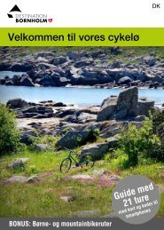
Bornholm has more than 230 kilometres of signposted<br />
<strong>cycling</strong> routes winding their way across the<br />
length and breadth of the island – through woods,<br />
along coasts, down small country roads and, usually,<br />
far from motorised traffic.<br />
All <strong>cycling</strong> routes on Bornholm are signposted<br />
with green signs and a number indicating the route<br />
you are biking on. If the sign has no arrows, it means<br />
you should bike straight ahead.<br />
The routes are part of Denmark’s <strong>cycling</strong> network<br />
and is also why the numbering of Bornholm’s routes<br />
starts with route 10, as this is part of the national<br />
<strong>cycling</strong> route. Routes 21–26 are regional routes,<br />
and in addition we have 8 recommended routes, 1<br />
children’s route, and 2 mountain bike routes. (The<br />
recommended route numbers are not displayed on<br />
the signs along the <strong>cycling</strong> tracks, as these sign<br />
numbers indicate the national and regional numbering<br />
systems.<br />
The centre pages show a map of Bornholm with<br />
all routes drawn in.<br />
Digital route maps<br />
Each route has a QR code<br />
and two website addresses.<br />
If you have a smart<br />
phone with Internet access,<br />
you can scan the QR code<br />
http://veloroutes.org/r/72308<br />
http://g.co/maps/v9tg<br />
and go directly to a very accurate route map. You can<br />
also use the <strong>free</strong> “ScanLife” app available at the App<br />
Store or the Android Market. The route map found at<br />
velo-routes.org also shows cont<strong>our</strong> lines in addition<br />
to route directions.<br />
5