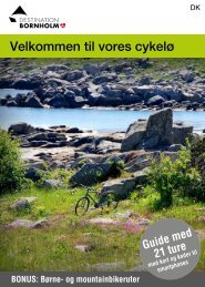
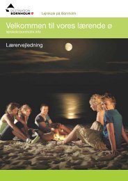
Get our free cycling brochure 2013 - Bornholms Velkomstcenter
Get our free cycling brochure 2013 - Bornholms Velkomstcenter
Get our free cycling brochure 2013 - Bornholms Velkomstcenter

Create successful ePaper yourself
Turn your PDF publications into a flip-book with our unique Google optimized e-Paper software.
32<br />
Recommended route 8 - Østerlars Kirke<br />
Gudhjem - Østerlars - Gudhjem<br />
27 km<br />
22 km asphalt · 5 km gravel<br />
Over half of this route, which has been cont<strong>our</strong> mapped<br />
with start and finish In Gudhjem, follows cycle tracks<br />
that are completely separated from other traffic. The<br />
rest of the route follows small minor roads. Start off<br />
along cycle route 10 from Gudhjem towards Melsted.<br />
The route can be completed in 1.5 h<strong>our</strong>s by an experienced<br />
cyclist.<br />
Just south of Gudhjem there is a little sandy beach<br />
that stretches from Melsted Harb<strong>our</strong> to Melsted Badehotel.<br />
At one end of the beach a little stream flows into<br />
the sea, where children can play for h<strong>our</strong>s building<br />
dams. At the other end of the beach there is a bathing<br />
jetty, so you won’t need to walk on the pebbles on the<br />
seabed. From the hotel terrace there is a marvellous<br />
view of the beach and the island of Christiansø in the<br />
distance.<br />
From Melsted, follow cycle route 25 inland. Soon<br />
you come to the beautiful Stavehøl Waterfall. Stavehøl<br />
is eight metres deep and two metres wide. With a drop<br />
of three metres, it is not the highest waterfall on the<br />
island, but a lovely sight none the less. There is a<br />
delightful walk from the waterfall along the Kobbeå<br />
Stream to the sea. Kobbeådalen is a fissure valley with<br />
steep and in some places almost vertical sides.<br />
At Østerlars you pass the islands - and Denmark’s<br />
- largest round church.<br />
http://veloroutes.org/r/72452<br />
http://g.co/maps/e695t<br />
You can make a det<strong>our</strong> starting from Østerlars<br />
Round Church to see the disused gneiss quarry,<br />
situated to the north. Follow the cycle route towards<br />
Gudhjem and turn left along Stangevej. Then follow<br />
the marked path. Today, the disused quarry is a little<br />
oasis with vertical rock walls. Gneiss is a striped, fine-grained<br />
rock consisting partly of quartz. Continue<br />
along cycle route 25 to the Almindingen forest, where<br />
you’ll find enough to see and do for a whole day. Before<br />
you get very deep into the forest y<strong>our</strong> route turns<br />
off along cycle route 26, but you can take a det<strong>our</strong><br />
to visit Ekkodalen, Gamleborg, Lilleborg or Rytterknægten.<br />
You can get a leaflet with a map of Almindingen<br />
from Bomholms <strong>Velkomstcenter</strong>, Ndr. Kystvej 3,<br />
Rønne, or from any other of the t<strong>our</strong>ist offices on the<br />
island.<br />
When cycle route 26 reaches Sigtevej, follow this<br />
road back to Gudhjem. Sigtevej runs through Rø<br />
Plantation, where you’ll see trees, heather, rocks and<br />
beautiful fissure valleys. Do park y<strong>our</strong> bike and take<br />
a walk around the artificial lake, where vertical rock<br />
walls rise out of the water.<br />
And then it’s back to Gudhjem, one of the island’s<br />
most attractive towns.<br />
Gudhjem*