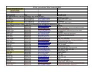
Training Guide in Surface Weather Observations - Multiple Choices
Training Guide in Surface Weather Observations - Multiple Choices
Training Guide in Surface Weather Observations - Multiple Choices

Create successful ePaper yourself
Turn your PDF publications into a flip-book with our unique Google optimized e-Paper software.
phenomenon caus<strong>in</strong>g the obscuration, a space, then the layer amount and height. For example, the<br />
Remark “HZ SCT000” <strong>in</strong>dicates that haze at the surface is hid<strong>in</strong>g 3/8 to 4/8 of the sky.<br />
8.2.1.5 Significant Cloud Types<br />
Certa<strong>in</strong> types of clouds are of particular importance to pilots. You are expected to be able to recognize<br />
them. The direction of movement is the direction toward which the clouds are mov<strong>in</strong>g.<br />
1. Cumulonimbus (CB) with or without an anvil. These are large cumulus-type clouds with dark<br />
bases and are threaten<strong>in</strong>g <strong>in</strong> appearance. Report CB followed by direction from station, and if<br />
known, the movement of the cloud with each entry separated by a space. For example, a CB up<br />
to 10 statute miles southeast of the station mov<strong>in</strong>g toward the north would be coded “CB VC SE<br />
MOV N.” A CB more than 10 statute miles east of the station would be coded “CB DSNT E.”<br />
2. Cumulonimbus Mamma (CBMAM). This is a dark cloud with rounded protuberances hang<strong>in</strong>g<br />
downward from its base. Report CBMAM followed by the direction from the station, and if<br />
known, the direction of movement of the cloud; e.g., “CBMAM ALQDS MOV N.” Append CB<br />
to the cloud layer <strong>in</strong> the body of the report.<br />
3. Tower<strong>in</strong>g Cumulus (TCU). This cloud is similar to “fair weather cumulus” but has a dist<strong>in</strong>ctly<br />
shaded, often dark base, and strong vertical development. Report TCU followed by the direction<br />
from the station; e.g., “TCU NW” or, if a tower<strong>in</strong>g cumulus cloud is more than 10 statute miles<br />
west of the station, you would code “TCU DSNT W.”<br />
4. Altocumulus Castellanus (ACC). These clouds are similar to cumulus clouds but are at a higher<br />
level and are usually smaller. Report ACC followed by the direction from the station. For<br />
example, an altocumulus cloud 5 to 10 statute miles northeast of the station would be coded<br />
“ACC VC NE.”<br />
5. Stand<strong>in</strong>g Lenticular, stratocumulus (SCSL), altocumulus (ACSL), or cirrocumulus (CCSL).<br />
These clouds usually form <strong>in</strong> patches <strong>in</strong> the shape of plates, saucers, lenses, etc. They typically<br />
form on the lee side of mounta<strong>in</strong>s or ridges and are often observed at several levels. Report the<br />
cloud type followed by the direction from the station; entries shall be separated by a space. For<br />
example, stratocumulus stand<strong>in</strong>g lenticular clouds observed east through south of the station<br />
would be coded “SCSL E-S,” and altocumulus stand<strong>in</strong>g lenticular clouds over the station would<br />
be coded “ACSL OHD.”<br />
6. Rotor Clouds. These clouds form on the lee side of mounta<strong>in</strong>s or ridges. Report ROTOR CLD<br />
followed by the direction from the station. For example, an apparent rotor cloud 5 to 10 statute<br />
miles northwest of the station would be coded “APRNT ROTOR CLD VC NW.”<br />
8.2.2 Additive Data Remarks<br />
8.2.2.1 3- and 6-Hourly Precipitation Amount<br />
The amount of precipitation (water equivalent) accumulated <strong>in</strong> the past 3 hours is reported <strong>in</strong> the 3hourly<br />
report, and the amount accumulated <strong>in</strong> the past 6 hours is reported <strong>in</strong> the 6-hourly report. The<br />
amount of precipitation is coded <strong>in</strong> the group 6RRRR, us<strong>in</strong>g the tens, units, tenths, and hundredths of<br />
<strong>in</strong>ches. For example, 0.15 <strong>in</strong>ches of precipitation would be coded 60015. If an <strong>in</strong>determ<strong>in</strong>able amount<br />
of precipitation occurred dur<strong>in</strong>g the observ<strong>in</strong>g period, 6//// is coded. A trace is coded 60000. If no<br />
precipitation occurred dur<strong>in</strong>g the observ<strong>in</strong>g period, the group is omitted.<br />
8-3