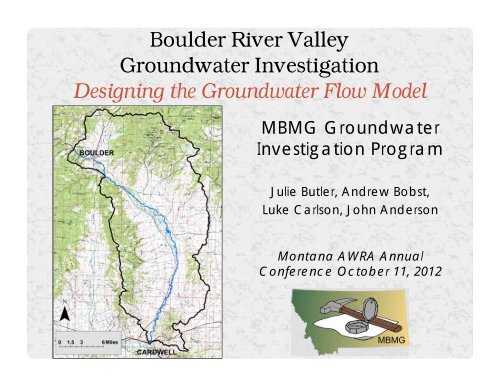
Julie Ahern Butler. Boulder River Valley Groundwater Investigation
Julie Ahern Butler. Boulder River Valley Groundwater Investigation
Julie Ahern Butler. Boulder River Valley Groundwater Investigation

You also want an ePaper? Increase the reach of your titles
YUMPU automatically turns print PDFs into web optimized ePapers that Google loves.
<strong>Boulder</strong> <strong>River</strong> <strong>Valley</strong><br />
<strong>Groundwater</strong> <strong>Investigation</strong><br />
Designing the <strong>Groundwater</strong> Flow Model<br />
MBMG <strong>Groundwater</strong><br />
<strong>Investigation</strong> Program<br />
<strong>Julie</strong> <strong>Butler</strong>, Andrew Bobst,<br />
Luke Carlson, John Anderson<br />
Montana AWRA Annual<br />
Conference October 11, 2012
• Study Objectives<br />
OUTLINE<br />
• Building the Conceptual Model<br />
o Field Work<br />
o Data Analysis<br />
• Building the Numerical Model<br />
o Grid Design<br />
o Calibration & Uncertainty Analysis<br />
• Summary
PROBLEM STATEMENT<br />
CAUSE:<br />
Parts of the <strong>Boulder</strong> <strong>River</strong><br />
regularly run dry during late<br />
summer<br />
Senior water rights holders<br />
unable to irrigate<br />
EFFECTS:<br />
Concern over current and<br />
future groundwater<br />
development reducing stream<br />
flows<br />
Interest in enhancing latersummer<br />
flows via springtime<br />
peak-flow diversions (aka<br />
managed recharge)
OBJECTIVES<br />
• Evaluate hydrogeologic effects of current and<br />
potential future groundwater development<br />
• Evaluate the potential for increasing late-summer<br />
flows through managed aquifer recharge<br />
----------------------------------------------------------------------<br />
• Approaches<br />
• Characterize the physical groundwater flow system<br />
• Quantify surface-water – groundwater interactions<br />
Conceptual model<br />
Numerical model
• Install Wells<br />
• 8 Bedrock Wells<br />
• 6 Alluvial Wells<br />
• 9 Canal Transect Wells<br />
• Monitor<br />
• <strong>Groundwater</strong><br />
• Surface Water<br />
• Canals<br />
• Water Quality<br />
• Run Aquifer Tests<br />
• 14 Sites<br />
FIELD WORK
POTENTIOMETRIC SURFACE MAP<br />
(MARCH, 2012)<br />
• Gradient reflects aquifer<br />
properties<br />
• Observations<br />
calibration targets<br />
• Aquifer property estimates<br />
prior information<br />
monitoring site<br />
aquifer test site
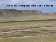
SURFACE-WATER – GROUNDWATER INTERACTIONS
Flume<br />
Canal<br />
Transect<br />
DITCH LEAKAGE
Ditch @ transect<br />
DITCH LEAKAGE<br />
Ditch @ flume<br />
Loss<br />
Median: 2.2 cfs/mile<br />
Ditch leakage recharges<br />
groundwater & supplements<br />
stream flow.
GEOLOGIC FRAMEWORK<br />
GWIC (public online database):<br />
http://mbmggwic.mtech.edu<br />
Inventoried wells<br />
Verified locations<br />
Assigned altitudes<br />
Interpreted lithologies<br />
Imported as boreholes<br />
Built cross sections
• Start simple<br />
• Slowly build complexity<br />
if it will enhance<br />
predictions<br />
GRID DESIGN
BOUNDARY CONDITIONS & CALIBRATION<br />
• Boundary Conditions<br />
o <strong>River</strong> & creeks<br />
o Ditches<br />
o Pumping wells<br />
• Calibration targets<br />
o Water levels<br />
o Stream flow<br />
o <strong>Groundwater</strong>-river interaction<br />
• Parameter Estimation<br />
o Inverse modeling<br />
o Prior information
MODEL DOMAINS: AVOIDING THE ALL-PURPOSE MODEL<br />
• No one model “fits all”<br />
• Recall: model = predictive tool<br />
o Impact of current and<br />
potential future groundwater<br />
development on river flow<br />
o Impact of managed recharge<br />
to on late-summer river flows<br />
• Each model meets a specific<br />
predictive objective<br />
North<br />
Model<br />
Focus<br />
Model<br />
South<br />
Model
Infiltration Ponds<br />
<strong>Groundwater</strong> Monitoring Site<br />
Surface-Water Monitoring Site<br />
Stream<br />
Irrigation Ditch<br />
MODELING PURPOSE:<br />
PREDICTION<br />
Managed Recharge Example
UNCERTAINTY ANALYSIS<br />
Food for thought…<br />
All models are wrong<br />
We must embrace uncertainty and quantify the “wrongness”<br />
The goal is not to make “correct” predictions, but rather<br />
to make predictions with minimum error<br />
“A good model encapsulates what we know, and quantifies<br />
what we don’t”
SUMMARY<br />
• Conceptual Model Development – in progress<br />
o ~ 90 monitoring sites calibration targets<br />
o Strong local influence of ditch leakage<br />
o <strong>River</strong> conditions change through space and time<br />
• Numerical Model Development – in progress<br />
o 3 models<br />
o Boundary conditions to reflect aquifer recharge/discharge<br />
o Calibrating to observations and “prior information”<br />
• Key Principles<br />
o Parsimony<br />
o Tailor to the purpose<br />
o Quantify the “wrongness”
THANK YOU<br />
QUESTIONS???