Download - Wisconsin Department of Natural Resources
Download - Wisconsin Department of Natural Resources
Download - Wisconsin Department of Natural Resources

You also want an ePaper? Increase the reach of your titles
YUMPU automatically turns print PDFs into web optimized ePapers that Google loves.
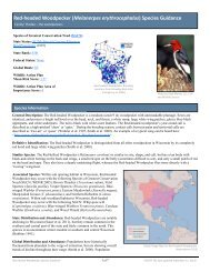
<strong>Wisconsin</strong>’s Strategy for Wildlife Species <strong>of</strong> Greatest Conservation Need<br />
2.2.3.7 Northeast Sands Ecological Landscape<br />
General Description<br />
The Northeast Sands Ecological Landscape occupies a relatively narrow, vertical<br />
band <strong>of</strong> land in northeast <strong>Wisconsin</strong> (Figure 2-21). This Ecological Landscape,<br />
formed in glacial outwash sand plains (some <strong>of</strong> them pitted), has steep outcropping<br />
Precambrian bedrock knolls <strong>of</strong> basalt, rhyolite, or granite. Sandy ground moraines<br />
and end moraines are also interspersed in the landscape.<br />
Vegetation<br />
Historically, extensive oak/jack pine barrens and jack pine forests were found<br />
in the outwash sand portions <strong>of</strong> this Ecological Landscape. Moraines<br />
supported forests <strong>of</strong> hardwoods, red pine, and white pine. Outwash plains<br />
<strong>of</strong>ten contained pitted depressions, resulting in numerous wetlands and kettle<br />
lakes.<br />
Most <strong>of</strong> this Ecological Landscape is still forested; aspen<br />
predominates, followed by northern hardwoods<br />
(Figure 2-22). Jack pine remains on the outwash plains along<br />
with northern pin oak. There are several important<br />
occurrences <strong>of</strong> jack pine/oak barren communities. A small<br />
percentage <strong>of</strong> this Ecological Landscape contains spruce-fircedar<br />
forest and lowland hardwood forest. The Brazeau<br />
Swamp is one <strong>of</strong> the best representations <strong>of</strong> large cedar<br />
swamp forests in northern <strong>Wisconsin</strong>.<br />
Hydrologic Features<br />
The Northeast Sands contains several important river systems<br />
as well as extensive wetlands. The Menominee is the largest,<br />
located on the Michigan-<strong>Wisconsin</strong> border. Several wild<br />
rivers in Landscape are the Wolf, Pine, Popple, and Pike.<br />
The Upper Peshtigo River runs through the Landscape's center<br />
and includes the Caldron Falls Flowage and the High Falls Reservoir.<br />
Extensive wetlands, including the Peshtigo Brook State<br />
Wildlife Area, are found here. This Ecological Landscape<br />
has high levels <strong>of</strong> watershed pollution, according to<br />
<strong>Wisconsin</strong> DNR, with three <strong>of</strong> five watersheds classified as<br />
highly polluted. Its lakes, though few, ranked second worst<br />
in pollution levels among the Ecological Landscapes.<br />
Land Use<br />
The total land area <strong>of</strong> the Northeast Sands Ecological<br />
Landscape is approximately 987,000 acres, <strong>of</strong> which 77% is<br />
classified as timberland. About a third <strong>of</strong> the Ecological<br />
Landscape is publicly owned (Figure 2-23), mostly by<br />
counties.<br />
Socioeconomics<br />
Socioeconomic data are summarized based on county-level<br />
approximations <strong>of</strong> the Ecological Landscape (referred to as a "region").<br />
Economic data are available only on a political unit basis with counties<br />
Page 2-27<br />
Other<br />
68%<br />
(private land,<br />
Wetland<br />
5%<br />
Forested<br />
Wetland<br />
15%<br />
roads, schools,<br />
cemetaries,<br />
military lands, etc.)<br />
Figure 2-21. Northeast<br />
Sands Ecological Landscape.<br />
Open Water<br />
3%<br />
Urban<br />
1%<br />
Agriculture<br />
7%<br />
County Forest<br />
23%<br />
Grassland<br />
7%<br />
Shrubland<br />
2%<br />
Forest<br />
60%<br />
Figure 2-22. Current land<br />
cover in the Northeast Sands<br />
Ecological Landscape.<br />
Figure 2-23. Public land<br />
ownership in the Northeast<br />
Sands Ecological Landscape.<br />
State<br />
2%<br />
Federal<br />
7%
![Nature program winter schedule [PDF] - Wisconsin DNR](https://img.yumpu.com/22471254/1/190x245/nature-program-winter-schedule-pdf-wisconsin-dnr.jpg?quality=85)
![City of Middleton [PDF] - Wisconsin Department of Natural Resources](https://img.yumpu.com/22300392/1/190x245/city-of-middleton-pdf-wisconsin-department-of-natural-resources.jpg?quality=85)
![Wetland Conservation Activities [PDF] - Wisconsin Department of ...](https://img.yumpu.com/21975633/1/190x245/wetland-conservation-activities-pdf-wisconsin-department-of-.jpg?quality=85)

![Baraboo River Region[PDF] - Wisconsin Department of Natural ...](https://img.yumpu.com/21975619/1/190x245/baraboo-river-regionpdf-wisconsin-department-of-natural-.jpg?quality=85)