Download - Wisconsin Department of Natural Resources
Download - Wisconsin Department of Natural Resources
Download - Wisconsin Department of Natural Resources

You also want an ePaper? Increase the reach of your titles
YUMPU automatically turns print PDFs into web optimized ePapers that Google loves.
<strong>Wisconsin</strong>’s Strategy for Wildlife Species <strong>of</strong> Greatest Conservation Need<br />
2.2.3.5 Northern Highlands Ecological Landscape<br />
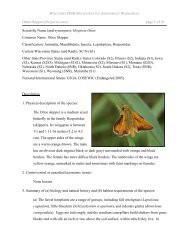
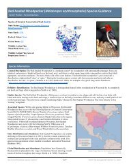
General Description<br />
The Northern Highlands Ecological Landscape is located in northern central<br />
<strong>Wisconsin</strong> (Figure 2-15). It is known for its pitted outwash plains and kettle lakes<br />
mixed with extensive forests and large peatlands. Its landforms are characterized<br />
mainly by pitted outwash but also contain some coarse-textured moraines. Soils<br />
are acidic and relatively unproductive due to low moisture-holding capacity and<br />
lack <strong>of</strong> organic matter.<br />
Vegetation<br />
Historically, this was <strong>Wisconsin</strong>'s greatest pinery. White and red pine<br />
forests largely dominated the vegetation, with some smaller pockets <strong>of</strong><br />
jack pine. On the more mesic soils, hemlock-hardwood forests were<br />
common. Aspen-birch forests occurred in openings formed by disturbance<br />
events such as wind or fire.<br />
Current forest vegetation is primarily aspen, with some<br />
white, red and jack pine in both natural and plantation form<br />
(Figure 2-16). Northern hardwood forests, though reduced in<br />
extent, still occur on the more mesic soils. Lowland conifer<br />
occupies the many peatlands that are scattered throughout the<br />
Ecological Landscape.<br />
Hydrologic Features<br />
The Northern Highlands is known for having one <strong>of</strong> the<br />
highest concentrations <strong>of</strong> kettle lakes in the world. The<br />
kettles were formed as glaciers melted, when large ice blocks<br />
became stranded and outwash materials were deposited over<br />
them. As the ice blocks slowly melted and collapsed, kettles were<br />
formed. Lakes developed in portions <strong>of</strong> kettles that were below the level<br />
<strong>of</strong> ground water. The sandy bottoms and shorelines <strong>of</strong> these lakes make<br />
them some <strong>of</strong> the most desirable areas for water recreation in<br />
the state. The <strong>Wisconsin</strong> and Manitowish are the two main<br />
rivers that run through the Ecological Landscape. Wetland<br />
types in this area such as open bog, fen, and wild rice marsh<br />
contain rare flora and fauna. Watershed pollution is about<br />
average for the state according to <strong>Wisconsin</strong> DNR.<br />
Land Use<br />
The Northern Highland Ecological Landscape comprises<br />
approximately 1.4 million acres <strong>of</strong> which 64% is forested.<br />
Almost 30% <strong>of</strong> the land is in public ownership<br />
(Figure 2-17), including the Northern<br />
Highland-American Legion State Forest.<br />
Socioeconomics<br />
Socioeconomic data are summarized based on county-level<br />
approximations <strong>of</strong> the Ecological Landscape (referred to as a "region").<br />
Economic data are available only on a political unit basis with counties<br />
as the smallest unit. The counties included in this socioeconomic region<br />
are Iron, Oneida, and Vilas (Northern Highland Region).<br />
Page 2-22<br />
Other<br />
Wetland<br />
12%<br />
Forested<br />
Wetland<br />
12%<br />
70%<br />
(private land,<br />
roads, schools,<br />
cemetaries,<br />
military lands, etc.)<br />
Figure 2-15. Northern Highlands<br />
Ecological Landscape.<br />
Open Water<br />
12%<br />
Urban<br />
1%<br />
County<br />
6%<br />
Agriculture<br />
1% Grassland<br />
3%<br />
Shrubland<br />
3%<br />
Forest<br />
56%<br />
Figure 2-16. Current land cover<br />
in the Northern Highland<br />
Ecological Landscape<br />
State<br />
20%<br />
Figure 2-17. Public land<br />
ownership in the Northern<br />
Highland Ecological Landscape<br />
Federal<br />
4%
![Nature program winter schedule [PDF] - Wisconsin DNR](https://img.yumpu.com/22471254/1/190x245/nature-program-winter-schedule-pdf-wisconsin-dnr.jpg?quality=85)
![City of Middleton [PDF] - Wisconsin Department of Natural Resources](https://img.yumpu.com/22300392/1/190x245/city-of-middleton-pdf-wisconsin-department-of-natural-resources.jpg?quality=85)
![Wetland Conservation Activities [PDF] - Wisconsin Department of ...](https://img.yumpu.com/21975633/1/190x245/wetland-conservation-activities-pdf-wisconsin-department-of-.jpg?quality=85)
![Baraboo River Region[PDF] - Wisconsin Department of Natural ...](https://img.yumpu.com/21975619/1/190x245/baraboo-river-regionpdf-wisconsin-department-of-natural-.jpg?quality=85)