Download - Wisconsin Department of Natural Resources
Download - Wisconsin Department of Natural Resources
Download - Wisconsin Department of Natural Resources

You also want an ePaper? Increase the reach of your titles
YUMPU automatically turns print PDFs into web optimized ePapers that Google loves.
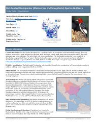
<strong>Wisconsin</strong>’s Strategy for Wildlife Species <strong>of</strong> Greatest Conservation Need<br />
• Consider the following technical resources when developing the environmental resource<br />
monitoring plan:<br />
− USGS Coordinated Bird Monitoring Plan (http://amap.wr.usgs.gov) and the WBCI<br />
Coordinated Bird Monitoring Plan (in prep.).<br />
− U.S. Geological Survey “Managers’ Monitoring Manual: How to Design a Wildlife<br />
Monitoring Program” http://www.pwrc.usgs.gov/monmanual.<br />
− U.S. Geological Survey “Designing Monitoring Programs in an Adaptive Management<br />
Context for Regional Multiple Species Conservation Plans”<br />
http://www.dfg.ca.gov/nccp/pubs/monframewk10-04.pdf.<br />
− National Park Service “Guidance for Designing an Integrated Monitoring Program”<br />
http://science.nature.nps.gov/im/monitor/vsmTG.htm#Design.<br />
• Consider the following data management and archiving systems in the environmental resource<br />
monitoring plan:<br />
− Conservation Registry: Schoonmaker, P. and W. Luscombe’s (2005) Habitat Monitoring: An<br />
Approach for Reporting Status and Trends for State Comprehensive Wildlife Conservation<br />
Strategies, recommends the establishment <strong>of</strong> a state-level registry <strong>of</strong> conservation actions.<br />
The proposed registry is a spatially explicit database <strong>of</strong> conservation actions that would<br />
include conservation goals, location, habitat type, type <strong>of</strong> action, etc. This would allow<br />
agencies and partners to display the relationship between conservation action and stated<br />
priorities as well as identify geographic or habitat gaps in implementation <strong>of</strong> the plan. Data<br />
for a <strong>Wisconsin</strong> conservation registry can be compiled based on metadata submitted to the<br />
Aquatic and Terrestrial <strong>Resources</strong> Inventory (ATRI). Submittal <strong>of</strong> metadata is required by<br />
WDNR for all SWG funded projects in the state.<br />
− Citizen-based Monitoring GIS Layer: The Citizen-based Monitoring Network <strong>of</strong> <strong>Wisconsin</strong><br />
will produce a GIS layer relating the kinds and geographic range <strong>of</strong> volunteer monitoring<br />
activities across the state. The tool will enable citizen-based monitoring groups to target<br />
monitoring gaps and access current monitoring data, protocols and monitoring guidance.<br />
− SWIMS: There are a variety <strong>of</strong> databases used by the WDNR to store water monitoring data,<br />
many <strong>of</strong> which are accessible to the public via the internet. However, these systems are not<br />
linked to one another and some are not easily accessible. To unify the various database<br />
systems and more easily access data from each <strong>of</strong> them, a project is underway to combine<br />
many <strong>of</strong> these databases as part <strong>of</strong> the new Surface Water Integrated Monitoring System<br />
(SWIMS), projected to be available by the end <strong>of</strong> 2006.<br />
− NHI: The <strong>Wisconsin</strong> <strong>Natural</strong> Heritage Inventory (NHI) program was established by the<br />
<strong>Wisconsin</strong> Legislature in 1985 and is part <strong>of</strong> an international network <strong>of</strong> NHI programs<br />
coordinated by NatureServe, a non-pr<strong>of</strong>it organization. These programs locate and document<br />
occurrences <strong>of</strong> rare species and natural communities (including state and federally<br />
endangered and threatened plants and animals) using a standard methodology for collecting,<br />
characterizing, and managing data. The programs maintain standardized databases with<br />
spatial and tabular components; the <strong>Wisconsin</strong> database contains over 21,000 records. In<br />
addition to its own inventory efforts, the <strong>Wisconsin</strong> program relies on data from contributors<br />
throughout the state. The <strong>Wisconsin</strong> NHI Working List contains the species and natural<br />
communities tracked by the program. <strong>Wisconsin</strong> NHI data are distributed at different levels<br />
<strong>of</strong> precision, depending on the user and the intended use <strong>of</strong> the data. Data with generalized<br />
locations can be obtained from the WDNR Web site by using either the “NHI Online<br />
Page 5-8
![Nature program winter schedule [PDF] - Wisconsin DNR](https://img.yumpu.com/22471254/1/190x245/nature-program-winter-schedule-pdf-wisconsin-dnr.jpg?quality=85)
![City of Middleton [PDF] - Wisconsin Department of Natural Resources](https://img.yumpu.com/22300392/1/190x245/city-of-middleton-pdf-wisconsin-department-of-natural-resources.jpg?quality=85)
![Wetland Conservation Activities [PDF] - Wisconsin Department of ...](https://img.yumpu.com/21975633/1/190x245/wetland-conservation-activities-pdf-wisconsin-department-of-.jpg?quality=85)
![Baraboo River Region[PDF] - Wisconsin Department of Natural ...](https://img.yumpu.com/21975619/1/190x245/baraboo-river-regionpdf-wisconsin-department-of-natural-.jpg?quality=85)