The Map that Named America
The Map that Named America
The Map that Named America

You also want an ePaper? Increase the reach of your titles
YUMPU automatically turns print PDFs into web optimized ePapers that Google loves.
18 SPAN JANUARY/FEBRUARY 2006<br />
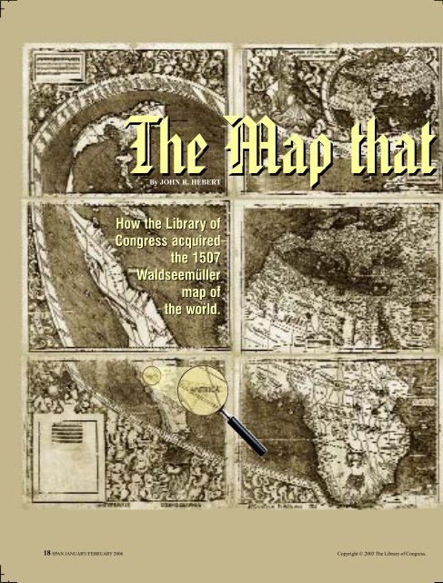
<strong>The</strong> <strong>Map</strong> <strong>that</strong><br />
By JOHN R. HÉBERT<br />
How the Library of<br />
Congress acquired<br />
the 1507<br />
Waldseemüller<br />
map of<br />
the world.<br />
Copyright © 2003 <strong>The</strong> Library of Congress.
<strong>Named</strong> <strong>America</strong><br />
SPAN JANUARY/FEBRUARY 2006 19
In late May 2003 the Library of Congress completed the<br />
purchase of the only surviving copy of the first image<br />
of the outline of the continents of the world as we know<br />
them today—Martin Waldseemüller’s monumental 1507<br />
world map.<br />
<strong>The</strong> map has been referred to in various circles as <strong>America</strong>’s<br />
birth certificate and for good reason; it is the first document on<br />
which the name “<strong>America</strong>” appears. It is also the first map to<br />
depict a separate and full Western Hemisphere and the first map<br />
to represent the Pacific Ocean as a separate body of water. <strong>The</strong><br />
purchase of the map concluded a nearly century-long effort to<br />
secure for the Library of Congress <strong>that</strong> very special cartographic<br />
document which revealed new European thinking about the<br />
world nearly 500 years ago.<br />
Martin Waldseemüller, the primary author of the 1507 world<br />
map, was a 16th-century scholar, humanist, cleric and<br />
cartographer who was part of the small intellectual circle, the<br />
Gymnasium Vosagense, in Saint-Dié, France. He was born near<br />
Freiburg, Germany, sometime in the 1470s and died in the canon<br />
house at Saint-Dié in 1522. During his lifetime he devoted much<br />
of his time to cartographic ventures.<br />
Thus, in a remote part of northeast France, was born the<br />
famous 1507 world map, whose full title is “Universalis<br />
cosmographia secunda Ptholemei traditionem et Americi<br />
Vespucci aliorum que lustrationes” (“A drawing of the whole<br />
earth following the tradition of Ptolemy and the travels of<br />
Amerigo Vespucci and others.”). That map, printed on 12<br />
separate sheets, each 45-by-60 centimeters, from wood block<br />
plates, measured more than 1.22 meters by 2.44 meters in<br />
dimension when assembled.<br />
<strong>The</strong> large map is an early 16th-century masterpiece,<br />
containing a full map of the world, two inset maps showing<br />
separately the Western and Eastern Hemispheres, illustrations of<br />
Ptolemy and Vespucci, images of the various winds and<br />
extensive explanatory notes about selected regions of the world.<br />
Waldseemüller’s map represented a bold statement <strong>that</strong><br />
rationalized the modern world in light of the exciting news<br />
arriving in Europe as a result of explorations across the Atlantic<br />
Ocean or down the African coast, which were sponsored by<br />
Spain, Portugal and others.<br />
<strong>The</strong> map must have created quite a stir in Europe, since its<br />
findings departed considerably from the accepted knowledge of<br />
the world at <strong>that</strong> time, which was based on the second century<br />
A.D. work of the Greek geographer, Claudius Ptolemy. To<br />
today’s eye, the 1507 map appears remarkably accurate; but to<br />
the world of the early 16th century it must have represented a<br />
considerable departure from accepted views of the composition<br />
of the world. Its appearance undoubtedly ignited considerable<br />
debate in Europe regarding its conclusions <strong>that</strong> an unknown<br />
continent (unknown, at least, to Europeans and others in the<br />
Eastern Hemisphere) existed between two huge bodies of water,<br />
the Atlantic and Pacific oceans, and was separated from the<br />
classical world of Ptolemy, which had been confined to the<br />
continents of Europe, Africa and Asia.<br />
20 SPAN JANUARY/FEBRUARY 2006<br />
A postcard circa 1900 showing Wolfegg Castle in Baden-<br />
Württemberg, Germany, where the map remained unknown to scholars<br />
until it was revealed in 1901 by Jesuit priest Josef Fischer, who was<br />
conducting research in the Waldburg collection.<br />
While it has been suggested <strong>that</strong> Waldseemüller incorrectly<br />
dismissed Christopher Columbus’ great achievement in history<br />
by the selection of the name “<strong>America</strong>” for the Western<br />
Hemisphere, it is evident <strong>that</strong> the information <strong>that</strong> Waldseemüller<br />
and his colleagues had at their disposal recognized Columbus’<br />
previous voyages of exploration and discovery.<br />
It is remarkable <strong>that</strong> the entire Western Hemisphere was<br />
named for a living person; Vespucci did not die until 1512. By<br />
1513, Waldseemüller had removed the name “<strong>America</strong>” from his<br />
maps, perhaps suggesting <strong>that</strong> even he had second thoughts<br />
about honoring Vespucci exclusively for his understanding of the<br />
New World. Instead, in the 1513 atlas, the area named<br />
“<strong>America</strong>” on the 1507 map is now referred to as Terra Incognita<br />
(Unknown Land).<br />
Cartographic contributions by Johannes Schöner in 1515 and<br />
by Peter Apian in 1520, however, adopted the name “<strong>America</strong>”<br />
for the Western Hemisphere, and <strong>that</strong> name then became part of<br />
accepted usage.<br />
A reported 1,000 copies of the 1507 map were printed, which<br />
was a sizable print run in those days. This single surviving copy<br />
of the map exists because it was kept in a portfolio by Schöner<br />
(1477-1547), a German globe maker, who probably had acquired<br />
a copy of the map for his own cartographic work. That portfolio<br />
contained not only the unique copy of the 1507 world map but<br />
also a unique copy of Waldseemüller’s 1516 large wall map (the<br />
“Carta Marina”) [in which South <strong>America</strong> is called Terra Nova<br />
(New World) and North <strong>America</strong> is called Cuba].<br />
At some later time, the family of Prince Waldburg-Wolfegg<br />
acquired and retained Schöner’s portfolio of maps in their castle<br />
in Baden-Württemberg, Germany, where it remained unknown<br />
to scholars until the beginning of the 20th century.<br />
<strong>The</strong> portfolio, with its great treasure, was uncovered and<br />
revealed to the world in 1901 by Jesuit priest Josef Fischer,<br />
who was conducting research in the Waldburg collection at<br />
Wolfegg Castle.<br />
In 1903 an elaborate set of facsimiles of the 1507 and the 1516<br />
maps, accompanied by a scholarly study by Fischer and Franz<br />
von Wieser, was published.
HEMANT BHATNAGAR<br />
<strong>The</strong> Library of Congress’ Geography and <strong>Map</strong> Division<br />
acquired the facsimiles of the 1507 and 1516 maps in 1903.<br />
Throughout the 20th century the Library continued to express a<br />
desire to acquire the 1507 map, if it were ever made available for<br />
sale. That time came in 1992 when Prince Johannes Waldburg-<br />
Wolfegg, the owner of the map, revealed in a conversation in<br />
Washington <strong>that</strong> he was willing to negotiate the sale of the map.<br />
In 1999 the prince notified the Library <strong>that</strong> the German<br />
government and the Baden-Württemberg state had granted<br />
permission for a limited export license. In late June 2001 the<br />
prince and the Library of Congress reached a final agreement on<br />
the sale of the map for the price of $10 million. In late May 2003<br />
the Library completed a successful campaign to raise the<br />
necessary funds, after receiving substantial congressional and<br />
private support.<br />
<strong>The</strong> map serves as a departure point for the development of the<br />
division’s <strong>America</strong>n cartographic collection in addition to its<br />
revered position in early modern cartographic history. <strong>The</strong> map<br />
provides a meaningful link between the Library’s treasured late<br />
medieval-early Renaissance cartographic collection (which<br />
includes one of the richest holdings of Ptolemy atlases in the<br />
world) and the modern cartographic age <strong>that</strong> unfolded as a result of<br />
the explorations of Columbus and other discoverers in the late 15th<br />
and early 16th centuries. It represents the point of departure from<br />
the geographical understanding of the world based on Ptolemy’s<br />
“Cosmographiae” and “Geographiae” (editions from 1475) to <strong>that</strong><br />
emerging in the minds of scholars and practical navigators as<br />
reports of the “new worlds” of <strong>America</strong>, southern Africa and other<br />
T he<br />
200-year-old U.S. Library of<br />
Congress is the world’s largest<br />
library, with 128 million publications.<br />
Laila Mulgaokar (left), born in Mumbai, is<br />
the <strong>America</strong>n field director of the New<br />
Delhi office, one of six overseas offices <strong>that</strong><br />
acquire, catalog and preserve published<br />
materials from around the world for use in<br />
the Washington, D.C., area Reading Rooms<br />
or the libraries of 49 <strong>America</strong>n universities.<br />
<strong>The</strong> 81 local specialists gather materials in<br />
65 languages: books, newspapers, journals,<br />
official gazettes, pamphlets, maps,<br />
audio and video recordings from India,<br />
Bangladesh, Bhutan, Burma, the Maldives,<br />
Nepal, Sri Lanka and Tibet. “<strong>The</strong> idea for<br />
overseas acquisitions activities for libraries<br />
arose in the 1950s at a time of widespread<br />
dissatisfaction in the Library of Congress<br />
regions of Asia and Oceania reached Europe’s shores.<br />
<strong>The</strong> Waldseemüller map joins the rich cartographic holdings<br />
of the Library’s Geography and <strong>Map</strong> Division, which include<br />
some 4.8 million maps, 65,000 atlases, more than 500 globes<br />
and globe gores, and thousands of maps in digital form. <strong>The</strong><br />
map’s acquisition provides scholars with an extraordinary<br />
opportunity to appreciate the earliest of early depictions of our<br />
modern world. Major portions of this 1507 world map have not<br />
received the same concentrated scrutiny as the <strong>America</strong>n<br />
segments. <strong>The</strong> very detailed depiction of sub-Saharan Africa,<br />
the south coast of Asia, and even the areas surrounding the<br />
Black and Caspian seas merit further study and discussion in<br />
response to obvious questions regarding the cartographic and<br />
geographic sources <strong>that</strong> were available and used by the Saint-<br />
Dié scholars to reach the conclusions <strong>that</strong> they embodied in the<br />
1507 world map.<br />
Through agreement with Prince Waldburg-Wolfegg and the<br />
Government of Germany, the 1507 Waldseemüller world map is<br />
placed on permanent display in the Library of Congress’ Thomas<br />
Jefferson Building. A second floor gallery, the Pavilion of the<br />
Discoverers, was chosen as an appropriate location to house the<br />
map, where it is exhibited with supporting materials from the<br />
Library’s collections <strong>that</strong> assist in describing the rich history<br />
surrounding the map and its relation to its creators and the<br />
sources used to prepare it in the 16th century. <br />
About the Author: John R. Hébert is chief of the Geography and <strong>Map</strong><br />
Division of the Library of Congress in Washington, D.C.<br />
Preserving the World’s Words<br />
and in <strong>America</strong>n academia with the lack of<br />
non-European materials,” says Mulgaokar.<br />
“We will collect anything and everything of<br />
research value, in all languages, in all formats,<br />
from all countries.” To preserve the<br />
world’s newspapers, law gazettes and legislative<br />
assembly debates for use by future<br />
researchers, the Library microfilms them.<br />
“We are working on a joint project with<br />
the <strong>America</strong>n Institute of Indian Studies in<br />
New Delhi,” Mulgaokar says. “AIIS has<br />
published several volumes of its<br />
Encyclopedia of Indian Temple Architecture,<br />
which consolidates all essential historical<br />
and technical information relating to the<br />
Indian temples in their many regional and<br />
period styles. We will first microfilm and<br />
then digitize their site drawings of these<br />
historical monuments.” —A.V.N.<br />
SPAN JANUARY/FEBRUARY 2006 21