June 11, 2008 - Colorado Oil and Gas Conservation Commission
June 11, 2008 - Colorado Oil and Gas Conservation Commission
June 11, 2008 - Colorado Oil and Gas Conservation Commission

Create successful ePaper yourself
Turn your PDF publications into a flip-book with our unique Google optimized e-Paper software.
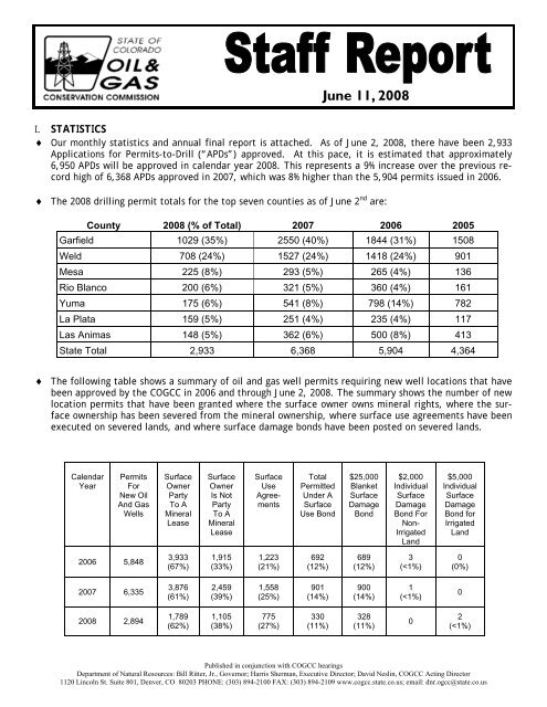
I. STATISTICS<br />
♦ Our monthly statistics <strong>and</strong> annual final report is attached. As of <strong>June</strong> 2, <strong>2008</strong>, there have been 2,933<br />
Applications for Permits-to-Drill (“APDs”) approved. At this pace, it is estimated that approximately<br />
6,950 APDs will be approved in calendar year <strong>2008</strong>. This represents a 9% increase over the previous record<br />
high of 6,368 APDs approved in 2007, which was 8% higher than the 5,904 permits issued in 2006.<br />
♦ The <strong>2008</strong> drilling permit totals for the top seven counties as of <strong>June</strong> 2 nd are:<br />
♦ The following table shows a summary of oil <strong>and</strong> gas well permits requiring new well locations that have<br />
been approved by the COGCC in 2006 <strong>and</strong> through <strong>June</strong> 2, <strong>2008</strong>. The summary shows the number of new<br />
location permits that have been granted where the surface owner owns mineral rights, where the surface<br />
ownership has been severed from the mineral ownership, where surface use agreements have been<br />
executed on severed l<strong>and</strong>s, <strong>and</strong> where surface damage bonds have been posted on severed l<strong>and</strong>s.<br />
Calendar<br />
Year<br />
2006<br />
Permits<br />
For<br />
New <strong>Oil</strong><br />
And <strong>Gas</strong><br />
Wells<br />
5,848<br />
2007 6,335<br />
<strong>2008</strong> 2,894<br />
Surface<br />
Owner<br />
Party<br />
To A<br />
Mineral<br />
Lease<br />
3,933<br />
(67%)<br />
3,876<br />
(61%)<br />
1,789<br />
(62%)<br />
Surface<br />
Owner<br />
Is Not<br />
Party<br />
To A<br />
Mineral<br />
Lease<br />
1,915<br />
(33%)<br />
2,459<br />
(39%)<br />
1,105<br />
(38%)<br />
Surface<br />
Use<br />
Agreements<br />
1,223<br />
(21%)<br />
1,558<br />
(25%)<br />
775<br />
(27%)<br />
Total<br />
Permitted<br />
Under A<br />
Surface<br />
Use Bond<br />
692<br />
(12%)<br />
901<br />
(14%)<br />
330<br />
(<strong>11</strong>%)<br />
<strong>June</strong> <strong>11</strong>, <strong>2008</strong><br />
County <strong>2008</strong> (% of Total) 2007 2006 2005<br />
Garfield 1029 (35%) 2550 (40%) 1844 (31%) 1508<br />
Weld 708 (24%) 1527 (24%) 1418 (24%) 901<br />
Mesa 225 (8%) 293 (5%) 265 (4%) 136<br />
Rio Blanco 200 (6%) 321 (5%) 360 (4%) 161<br />
Yuma 175 (6%) 541 (8%) 798 (14%) 782<br />
La Plata 159 (5%) 251 (4%) 235 (4%) <strong>11</strong>7<br />
Las Animas 148 (5%) 362 (6%) 500 (8%) 413<br />
State Total 2,933 6,368 5,904 4,364<br />
$25,000<br />
Blanket<br />
Surface<br />
Damage<br />
Bond<br />
689<br />
(12%)<br />
900<br />
(14%)<br />
328<br />
(<strong>11</strong>%)<br />
$2,000<br />
Individual<br />
Surface<br />
Damage<br />
Bond For<br />
Non-<br />
Irrigated<br />
L<strong>and</strong><br />
3<br />
(
2 <strong>Oil</strong> & <strong>Gas</strong> Staff Report<br />
II. NORTHWEST COLORADO<br />
♦ Northwest <strong>Colorado</strong> <strong>Oil</strong> <strong>and</strong> <strong>Gas</strong> Forum<br />
There was a meeting on <strong>June</strong> 5, <strong>2008</strong>, at the<br />
Garfield County Fairgrounds where the following<br />
items were discussed:<br />
• State, Federal, County, <strong>and</strong> Industry Updates<br />
on NW <strong>Colorado</strong> <strong>Oil</strong> & <strong>Gas</strong> Activity<br />
• BLM Activity Updates<br />
• Garfield County Update<br />
• South Piceance Water Resource Assessment,<br />
Data Repository<br />
• Roan Plateau Rim Pit NTo, Roan Creek &<br />
Parachute Creek Drainages<br />
The next meeting is scheduled for September 4,<br />
<strong>2008</strong>, at the Garfield County Fairgrounds in<br />
Rifle, CO.<br />
The Forum is an informal meeting of local,<br />
state, <strong>and</strong> federal government officials, oil <strong>and</strong><br />
gas industry representatives, <strong>and</strong> citizens that<br />
has been holding regularly scheduled meetings<br />
since 1989. The purpose of the Forum is to<br />
share information about oil <strong>and</strong> gas<br />
development in the northwest <strong>Colorado</strong> area<br />
<strong>and</strong> to make government officials <strong>and</strong> oil <strong>and</strong><br />
gas industry representatives easily accessible to<br />
the public. Currently the meetings are<br />
conducted once per quarter <strong>and</strong> are co-chaired<br />
by COGCC’s Acting Director, Dave Neslin, <strong>and</strong><br />
Garfield County <strong>Commission</strong>er Larry McCown.<br />
All parties wishing to be placed on the meeting<br />
agenda should contact Chris Canfield at 970-<br />
625-5682 or via email at:<br />
chris.canfield@state.co.us.<br />
♦ Meetings with Operators Regarding Issues<br />
Associated with Pits<br />
Jaime Adkins, Dave Andrews, Debbie Baldwin,<br />
Chris Canfield, <strong>and</strong> Kevin King met with<br />
operators in Battlement Mesa on May 21, <strong>2008</strong>,<br />
to discuss <strong>and</strong> develop the requirements to be<br />
included in a Notice to Operators (NTO) that<br />
would be drilling wells in proximity to the rim of<br />
the Roan Plateau. A draft of the NTO was<br />
discussed further at the NW <strong>Oil</strong> <strong>and</strong> <strong>Gas</strong> Forum<br />
<strong>June</strong> <strong>11</strong>, <strong>2008</strong><br />
on <strong>June</strong> 5, <strong>2008</strong>. The draft NTO acknowledges<br />
the continued need for the use of pits in <strong>and</strong><br />
the potential problems <strong>and</strong> environmental<br />
impacts that can occur even when a closed<br />
loop or semi-closed loop system is used.<br />
Nonetheless it encourages continued<br />
infrastructure development, <strong>and</strong> the evaluation<br />
<strong>and</strong> use of alternatives to pits. It includes<br />
proposed specifications for constructing, lining,<br />
operating, maintaining, monitoring, permitting,<br />
<strong>and</strong> closing pits.<br />
♦ Local Project Status Update<br />
The Garfield County Phase II Hydrogeologic<br />
Characterization Project is being conducted for<br />
Garfield County by S.S. Papadopulos &<br />
Associates. This is another Public Project In<br />
Lieu of Fines that will be funded by<br />
EnCana. Task 1 - Domestic Water Well<br />
Sampling was completed in August, 2007. Task<br />
2 - <strong>Gas</strong> Well Sampling was completed in<br />
December 2007. This sampling event included<br />
the collection of both produced water samples<br />
<strong>and</strong> production gas samples from selected<br />
wells. Final results were received in January<br />
<strong>2008</strong> <strong>and</strong> the project database was<br />
updated. Evaluation of both Task 1 <strong>and</strong> Task 2<br />
water quality data began in February <strong>2008</strong>. A<br />
draft report has been prepared <strong>and</strong> should be<br />
submitted to the Garfield County for review by<br />
<strong>June</strong> 16, <strong>2008</strong>. A water quality results<br />
guideline pamphlet is also being prepared for<br />
distribution with the final report.<br />
♦ Rulison Area<br />
The 3 operators that currently hold most of the<br />
oil <strong>and</strong> gas leases within 3 miles of the Project<br />
Rulison blast site, Noble Energy, Inc., Williams<br />
Production RMT, <strong>and</strong> EnCana <strong>Oil</strong> & <strong>Gas</strong> (USA)<br />
<strong>and</strong> a third- party consultant, URS Corporation<br />
(URS), have developed a comprehensive<br />
monitoring, sampling, analysis, <strong>and</strong> emergency<br />
response plan (Plan) for drilling activities<br />
within a 3-mile radius area around the test<br />
site. The Plan has been exp<strong>and</strong>ed to include<br />
monitoring for inorganic <strong>and</strong> non-radionuclide<br />
constituents. The Plan will be modified as<br />
necessary as additional data are collected. The<br />
revised Plan <strong>and</strong> all other documents related to<br />
Project Rulison <strong>and</strong> activities in the area have
<strong>Oil</strong> & <strong>Gas</strong> Staff Report<br />
been scanned <strong>and</strong> placed on the COGCC<br />
website under Project Number 1991.<br />
Quarterly meetings between COGCC <strong>and</strong><br />
CDPHE, DOE, <strong>and</strong> BLM will be conducted to<br />
review oil <strong>and</strong> gas activities in the area <strong>and</strong> to<br />
discuss the results of monitoring by industry<br />
<strong>and</strong> the DOE.<br />
♦ Rio Blanco Area<br />
Project Rio Blanco was the second <strong>and</strong> final<br />
underground nuclear blast conducted by the<br />
Atomic Energy <strong>Commission</strong>, the predecessor to<br />
the Department of Energy (DOE), to investigate<br />
the use of nuclear explosives to stimulate gas<br />
production in <strong>Colorado</strong>. The target formations<br />
for this test were the Mesa Verde <strong>and</strong> Fort<br />
Union Formations in Rio Blanco County,<br />
approximately 52 miles northeast of Gr<strong>and</strong><br />
Junction. Meetings between COGCC, CDPHE,<br />
DOE , BLM <strong>and</strong> industry will be scheduled as<br />
needed to review oil <strong>and</strong> gas activities in the<br />
area around the Rio Blanco test site <strong>and</strong> to<br />
discuss the results of monitoring by industry<br />
<strong>and</strong> the DOE.<br />
♦ Study of Baseline Water Quality, Plateau Creek<br />
Drainage Area, Mesa County<br />
Because of the extremely heavy workload <strong>and</strong><br />
personnel changes, initiation of this project has<br />
been delayed. Staff is hopeful that the water<br />
well sampling will begin during the summer.<br />
III. SOUTHWEST COLORADO<br />
♦ Ongoing Investigation, Reclamation, <strong>and</strong><br />
Mitigation of Residual Methane in the Vicinity<br />
of the Bryce 1-X Well Area, Bondad, <strong>Colorado</strong><br />
A soil gas survey was conducted by LT<br />
Environmental (LTE) on May 13, <strong>2008</strong>, using the<br />
same sampling grid as previous soil gas surveys.<br />
LTE reported that methane was not detected in<br />
the shallow soils, which is consistent with the<br />
three previous soil gas surveys. The written<br />
report on the results of the May 13, <strong>2008</strong>,<br />
survey is complete <strong>and</strong> available on the COGCC<br />
website Library. Additional soil gas surveys will<br />
continue in <strong>2008</strong> to verify the lack of methane<br />
in the shallow soils.<br />
<strong>June</strong> <strong>11</strong>, <strong>2008</strong><br />
Groundwater sampling of vicinity water wells<br />
was also conducted on May 13, <strong>2008</strong>, by Four<br />
Corners Geoscience (FCG). Methane<br />
concentrations have decreased in all water<br />
wells since the last sampling event in<br />
December 2007. Full analytical <strong>and</strong> isotopic<br />
results are pending. The next round of<br />
groundwater sampling from vicinity water wells<br />
is scheduled for late <strong>2008</strong>.<br />
♦ <strong>Gas</strong> <strong>and</strong> <strong>Oil</strong> Regulatory Team (GORT) Meeting<br />
The GORT/Southwest <strong>Colorado</strong> <strong>Oil</strong> <strong>and</strong> <strong>Gas</strong><br />
Stakeholders meeting was held on <strong>June</strong> 5,<br />
<strong>2008</strong>, in the La Plata Room at the La Plata<br />
County Fairgrounds. All parties wishing to be<br />
placed on the next meeting agenda should<br />
contact either Karen Spray at 970-259-1619 or<br />
karen.spray@state.co.us, or Debbie Baldwin at<br />
303-894-2100 ext. <strong>11</strong>1 or<br />
debbie.baldwin@state.co.us .<br />
♦ Fruitl<strong>and</strong> Formation Outcrop Mitigation <strong>and</strong><br />
Monitoring Projects<br />
Debbie Baldwin, Karen Spray, <strong>and</strong> Steve<br />
Lindblom continue to work with La Plata<br />
County Energy Council, La Plata <strong>and</strong> Archuleta<br />
County, <strong>and</strong> USFS/US BLM personnel to develop<br />
work plans for the gas seep monitoring <strong>and</strong><br />
mitigation projects in La Plata <strong>and</strong> Archuleta<br />
Counties. Funding for these projects comes<br />
from the COGCC mill levy on production.<br />
Surface access agreements with federal<br />
agencies <strong>and</strong> private property owners are in the<br />
process of being negotiated <strong>and</strong> memorialized.<br />
An Archeological Survey Scope of Work has been<br />
completed <strong>and</strong> initial cost estimates are being<br />
evaluated. A contracting mechanism will be<br />
determined based upon the results of these<br />
estimates.<br />
COGCC has implemented an interagency<br />
agreement with the <strong>Colorado</strong> Geological Survey<br />
(CGS) <strong>and</strong> approved a Scope of Work <strong>and</strong> cost<br />
proposal from the CGS that outlines a plan to<br />
conduct detailed geologic mapping of the<br />
Fruitl<strong>and</strong> Formation outcrop in Archuleta<br />
County. This work will be similar to mapping<br />
done in 1999-2000 by the CGS as part of the 3M<br />
Project. This project will encompass mapping<br />
3
4 <strong>Oil</strong> & <strong>Gas</strong> Staff Report<br />
the extent of the Fruitl<strong>and</strong> Formation coal beds<br />
for approximately 23 miles. The <strong>Colorado</strong> <strong>Oil</strong><br />
<strong>and</strong> <strong>Gas</strong> <strong>Conservation</strong> <strong>Commission</strong> will<br />
administer this project. The work proposed<br />
includes mapping (at 1:24,000 scale) the<br />
surface expression of the uppermost<br />
Cretaceous units, Pictured Cliffs S<strong>and</strong>stone,<br />
Fruitl<strong>and</strong> Formation, Kirtl<strong>and</strong> Shale, along the<br />
rim of the San Juan Basin in Archuleta County<br />
between the La Plata-Archuleta County line<br />
<strong>and</strong> the northern boundary of the Southern Ute<br />
Indian Reservation. The unit contacts that will<br />
be mapped include:<br />
• Lewis Shale/Pictured Cliffs S<strong>and</strong>stone<br />
• Pictured Cliffs S<strong>and</strong>stone/Fruitl<strong>and</strong> Formation<br />
• Fruitl<strong>and</strong> Formation/Kirtl<strong>and</strong> Shale<br />
• Kirtl<strong>and</strong> Shale/Animas Formation<br />
In addition to these geologic contacts, the<br />
locations of springs <strong>and</strong> methane seeps, if<br />
present, will also be recorded <strong>and</strong> geologic<br />
cross sections will be constructed from<br />
measured sections <strong>and</strong> geophysical logs from<br />
gas wells.<br />
CGS is using faculty <strong>and</strong> staff from Fort Lewis<br />
College in Durango to assist in the mapping<br />
project. Field work has been initiated <strong>and</strong> a<br />
meeting between COGCC, CGS, <strong>and</strong> Fort Lewis<br />
faculty was held on May 6, <strong>2008</strong>, in conjunction<br />
with a flyover to facilitate photographing the<br />
outcrop <strong>and</strong> to determine appropriate locations<br />
for measuring sections of the geologic units of<br />
interest.<br />
LT Environmental (LTE) was selected as the<br />
contractor for the 4M Outcrop Mitigation<br />
Project in La Plata County (Proposal PHA-827).<br />
LTE was selected based on team experience,<br />
project approach <strong>and</strong> a cost benefiting the<br />
State of <strong>Colorado</strong>. The contract has been<br />
approved <strong>and</strong> signed by all state agencies. The<br />
kickoff meeting for the project was held on<br />
<strong>June</strong> 5, <strong>2008</strong>. The first stage will be system<br />
design at both the South Fork of Texas Creek<br />
<strong>and</strong> Pine River locations, followed by<br />
installation <strong>and</strong> testing later this summer. If<br />
recovered methane characteristics are<br />
determined to be suitable, then micro-turbine<br />
<strong>June</strong> <strong>11</strong>, <strong>2008</strong><br />
technology will be tested to determine whether<br />
it can be used to generate electricity from the<br />
recovered methane to power the remediation<br />
systems. The outcrop methane flux data<br />
collected in 2007 <strong>and</strong> discussed below is an<br />
integral component of this project.<br />
A Request for Proposal (RFP) for the Fruitl<strong>and</strong><br />
Formation Geologic Characterization <strong>and</strong><br />
Reservoir Pressure Monitoring (PHA-837) was<br />
posted on April 24, <strong>2008</strong>. A pre-bid onsite<br />
meeting was held on May 5, <strong>2008</strong>. Proposals<br />
are due on <strong>June</strong> 13, <strong>2008</strong>, <strong>and</strong> contractor<br />
selection will be completed shortly thereafter.<br />
After contractor selection <strong>and</strong> after completion<br />
of the archeological <strong>and</strong> threatened <strong>and</strong><br />
endangered species surveys, permits will be<br />
obtained from the U.S. Forest Service to<br />
conduct the work. Permits for access across<br />
Southern Ute Indian Tribe l<strong>and</strong>s to reach some<br />
of the proposed well locations were requested<br />
from the Tribe on May 19, <strong>2008</strong>.<br />
COGCC staff is also developing a Scope of Work<br />
for the La Plata County Fruitl<strong>and</strong> Formation<br />
Additional Characterization <strong>and</strong> Monitoring<br />
Project.<br />
♦ 3M Fruitl<strong>and</strong> Formation Outcrop Monitoring<br />
Well Data Collection<br />
Karen Spray <strong>and</strong> Norwest Applied Hydrology<br />
(NAH) visited all existing outcrop monitoring<br />
well locations on May 6, <strong>2008</strong>, to download<br />
data <strong>and</strong> perform routine O&M at the wells. All<br />
sites were accessible <strong>and</strong> no major operational<br />
problems were noted. AHA will be providing a<br />
written report covering data collected through<br />
May 6, <strong>2008</strong>, in the near future. When<br />
published, it will be available on the COGCC<br />
website (www.cogcc.state.co.us, Library, San<br />
Juan Basin).<br />
♦ La Plata County – 2007 Fruitl<strong>and</strong> Outcrop<br />
Monitoring Report<br />
Since 1997, operators have been monitoring<br />
methane seeps on the outcrop of the Fruitl<strong>and</strong><br />
Formation north of the Southern Ute Indian<br />
Tribe (SUIT) Reservation boundary in La Plata<br />
County. The objectives of the monitoring<br />
program are to ensure the safety of the public
<strong>Oil</strong> & <strong>Gas</strong> Staff Report<br />
<strong>and</strong> the environment by systematically<br />
observing <strong>and</strong> documenting the relative change<br />
in methane seepage from the outcrop. The<br />
field methods of the monitoring program<br />
include methane seep mapping in known seep<br />
areas; regional reconnaissance along the entire<br />
outcrop using infrared imagery (IR) <strong>and</strong> field<br />
verification (pedestrian surveys); <strong>and</strong><br />
monitoring of natural springs. The most recent<br />
regional reconnaissance of the entire outcrop<br />
was conducted in 2005 <strong>and</strong> was discussed in the<br />
2006 monitoring report. The next regional<br />
reconnaissance is scheduled for <strong>2008</strong>.<br />
During the 2007 monitoring event, a portable<br />
flux meter capable of detecting the presence<br />
of methane at very low levels was used for the<br />
first time as part of this ongoing work. <strong>Gas</strong><br />
measurement data were used to estimate a<br />
total methane flux from the Fruitl<strong>and</strong> outcrop<br />
north of the SUIT line in La Plata County. A<br />
total methane flux of 7,125 thous<strong>and</strong> cubic<br />
feet per day (MCFD) was estimated using the<br />
2007 data. Overall methane concentrations in<br />
the seep areas appear to be slightly lower in<br />
2007 than 2006, but the aerial extent of<br />
methane seepage in 2007 was slightly greater<br />
than in 2006.<br />
The La Plata County – 2007 Fruitl<strong>and</strong> Outcrop<br />
Monitoring Report is available on the COGCC<br />
website (www.cogcc.stat.co.us, Library, San<br />
Juan Basin, La Plata County Reports). At the<br />
<strong>Commission</strong>’s request a presentation of the<br />
results can be made at a future hearing.<br />
♦ Archuleta County – 2007 Fruitl<strong>and</strong> Outcrop<br />
Monitoring Report<br />
On behalf of Elm Ridge Resources, Inc. (Elm<br />
Ridge) <strong>and</strong> Petrox Resources, Inc. (Petrox), the<br />
majority lease holders in the eastern half of<br />
the northern rim of the San Juan Basin (SJB) in<br />
Archuleta County, <strong>Colorado</strong>, LT Environmental,<br />
Inc. (LTE) conducted the fourth annual<br />
monitoring program along the Fruitl<strong>and</strong><br />
Formation (Kf) outcrop in Archuleta County.<br />
This report is available on the COGCC website<br />
under Library.<br />
The project area includes approximately 18<br />
miles of Kf outcrop starting from the La Plata<br />
<strong>June</strong> <strong>11</strong>, <strong>2008</strong><br />
County – Archuleta County boundary <strong>and</strong><br />
extending southeast along the outcrop to the<br />
Southern Ute Indian Tribe (SUIT) Reservation<br />
Boundary near the confluence of the Piedra<br />
River <strong>and</strong> Stollsteimer Creek. The purpose of<br />
the program is to identify the presence of<br />
methane seepage along the Kf outcrop <strong>and</strong> if<br />
observed, to monitor changes in seepage<br />
conditions over time <strong>and</strong> space. A similar<br />
program has been underway along the Kf<br />
outcrop in La Plata County since 1997. The<br />
overriding goal of the monitoring program is to<br />
ensure the safety of the public.<br />
IV. NORTHEAST COLORADO<br />
♦ Upper Crow Creek Designated Ground Water<br />
Basin Study<br />
The COGCC will be performing a baseline water<br />
quality study in the Upper Crow Creek<br />
Designated Ground Water Basin in northern<br />
Weld County. The High Plains Aquifer is<br />
present in this area <strong>and</strong> makes up an important<br />
regional aquifer in eastern <strong>Colorado</strong>. The study<br />
is being undertaken due to an increase in<br />
drilling activity in this area. Ground water<br />
samples will be collected from 25 existing<br />
domestic water wells <strong>and</strong> analyzed for both<br />
organic <strong>and</strong> inorganic constituents.<br />
This information will result in a more<br />
comprehensive baseline database that COGCC<br />
staff will use as a tool in responding to<br />
l<strong>and</strong>owners who allege impacts to water wells<br />
from oil <strong>and</strong> gas activities in the basin. The<br />
data will also help determine if revised<br />
regulatory requirements are warranted<br />
regarding the use of unlined earthen pits in this<br />
area. Monies from the Special Environmental<br />
<strong>and</strong> Mitigation Studies of the <strong>Colorado</strong> <strong>Oil</strong> <strong>and</strong><br />
<strong>Gas</strong> <strong>Conservation</strong> <strong>and</strong> Environmental Response<br />
Fund (Fund 170) will be used for this study.<br />
The project has been awarded to Terracon<br />
Consultants, Inc. with field work scheduled to<br />
begin on <strong>June</strong> 2 <strong>and</strong> should be completed by<br />
the end of the month. The final report will be<br />
completed by July <strong>2008</strong>.<br />
5
6 <strong>Oil</strong> & <strong>Gas</strong> Staff Report<br />
V. SOUTHEAST COLORADO<br />
♦ Monitoring, Investigation <strong>and</strong> Mitigation of<br />
Huerfano County Water Wells Venting Methane<br />
Monitoring<br />
On May 21, <strong>2008</strong>, Norwest Applied Hydrology<br />
(NAH), on behalf of Petroglyph Energy Inc.<br />
(PEI), submitted a summary of activities from<br />
April 15 to May 16, <strong>2008</strong>. The document <strong>and</strong><br />
the data submitted with the monthly report are<br />
posted on the website.<br />
NAH, on behalf of PEI continues screening<br />
water wells in <strong>and</strong> around the area where<br />
domestic water wells have been impacted by<br />
thermogenic methane. During the most recent<br />
reporting period from April 15, <strong>2008</strong>, to May<br />
16, <strong>2008</strong>, NAH screened 55 water wells. NAH<br />
reported that 44 of the monitored wells<br />
showed little change from the previous month’s<br />
monitoring. Six of the monitored wells showed<br />
decreases in concentration of combustible<br />
gases venting from the wells. Three of the<br />
monitored wells showed slight increases in gas<br />
concentration. Two water wells showed<br />
sporadic variation in concentration of<br />
combustible gases at the well head.<br />
<strong>Gas</strong> flow from a water well in Section 3,<br />
Township 29 South, Range 67 West, 6 th P.M.<br />
has been monitored continuously since August<br />
2007. <strong>Gas</strong> flow from this water well was<br />
relatively constant for the first 6 months of<br />
monitoring (approximately 50 MCF/day). <strong>Gas</strong><br />
flow from this water well decreased rapidly in<br />
March <strong>and</strong> April <strong>2008</strong> to a level that cannot be<br />
readily measured. This decrease in gas flow<br />
from a seriously impacted water well coincides<br />
with drilling of several methane removal <strong>and</strong><br />
injection wells by Petroglyph as part of the<br />
MIMMP.<br />
At the request of l<strong>and</strong>owners, the COGCC with<br />
its contractor Whetstone Associates continues<br />
to monitor 2 impacted water wells located in<br />
Sections 10 <strong>and</strong> 15, Township 29 South, Range<br />
67 West, 6 th P.M. <strong>Gas</strong> flow rates in the<br />
domestic water well located in Section 15 have<br />
been relatively constant through March, April<br />
<strong>and</strong> May <strong>2008</strong>, while the flow of methane from<br />
the domestic water well in Section 10 has<br />
<strong>June</strong> <strong>11</strong>, <strong>2008</strong><br />
decreased to a level that cannot be readily<br />
measured.<br />
Potential methane surface seeps were<br />
investigated in mid-May <strong>2008</strong> by PEI using a<br />
helicopter as the platform for the monitoring<br />
device. Data obtained during this survey is<br />
being processed <strong>and</strong> a summary will be<br />
provided by PEI in a future report.<br />
Investigation<br />
The monitoring well investigation report was<br />
submitted on March 31, <strong>2008</strong>. COGCC retained<br />
a third-party contractor to conduct a review<br />
<strong>and</strong> analyze the results of the report. The<br />
review of the monitoring well report was sent<br />
to Petroglyph on May 27, <strong>2008</strong>. Both the<br />
monitoring well report <strong>and</strong> the third-party<br />
review document are posted on the website<br />
Mitigation<br />
PEI is working with a homeowner on cost<br />
sharing for a cistern to vent methane from the<br />
water prior to it entering the residential<br />
structure. PEI started drilling the remediation<br />
wells on March 17, <strong>2008</strong>, <strong>and</strong> anticipates<br />
completing the work within 6 to 8 weeks. The<br />
drilling program includes 4 pumping wells <strong>and</strong> 8<br />
extraction wells. Testing of the remediation<br />
wells is anticipated to last through May <strong>2008</strong>.<br />
PEI is currently supplying water to <strong>11</strong> homes.<br />
Four recovery wells <strong>and</strong> 8 injection wells have<br />
been drilled by PEI as part of Phase 1 of the<br />
MIMMP. The last of these was completed on<br />
May 10, <strong>2008</strong>. One recovery well was<br />
subsequently plugged <strong>and</strong> ab<strong>and</strong>oned as it had<br />
not produced water or gas. Three of the<br />
MIMMP wells were producing a total of 70MCF/<br />
day in the middle of May <strong>2008</strong>, with no<br />
production of water. Pressure gages have been<br />
installed in each of the wells <strong>and</strong> the wells<br />
have been shut in for a two-week period.<br />
Pump testing will start upon completion of the<br />
pressure buildup tests. Samples of Poison<br />
Canyon Formation water will be collected <strong>and</strong><br />
submitted for analysis to gather information to<br />
be used in PEI’s applications to the EPA for<br />
injection permits. PEI will submit a report to<br />
the COGCC <strong>and</strong> the EPA summarizing the<br />
results of the aquifer tests.
<strong>Oil</strong> & <strong>Gas</strong> Staff Report<br />
Emergency Planning<br />
PEI submitted the Monitoring <strong>and</strong> Response<br />
Plan to the COGCC <strong>and</strong> it has been posted on<br />
the website.<br />
COGCC Outreach<br />
Margaret Ash met with Valois Shea of the EPA<br />
on April 28, <strong>2008</strong>, to discuss the status of the<br />
project <strong>and</strong> the path forward, <strong>and</strong> to exchange<br />
data.<br />
Peter Gintautas provided an update on the<br />
Phase I investigation <strong>and</strong> ongoing monitoring<br />
<strong>and</strong> mitigation activities to the Huerfano<br />
County <strong>Commission</strong> meeting in Walsenburg on<br />
May 14, <strong>2008</strong>. He will present another update<br />
of Petroglyph’s Phase 1 MIMMP activities to the<br />
Huerfano County <strong>Commission</strong> on <strong>June</strong> 25, <strong>2008</strong>.<br />
♦ Elbert County Pit Investigation Project (PHA-<br />
835)<br />
An investigation of oil <strong>and</strong> gas exploration <strong>and</strong><br />
production pits in Elbert County is being<br />
conducted. The investigation has 2 objectives:<br />
1. To evaluate the accuracy <strong>and</strong> completeness<br />
of the information in the COGCC web-based<br />
information system (COGIS) database for<br />
facilities in Elbert County, <strong>and</strong><br />
2. To locate <strong>and</strong> evaluate the status of pits<br />
listed in the COGCC database for Elbert<br />
County. The investigation will determine if<br />
the pits are still active, closed, or<br />
ab<strong>and</strong>oned. Pit status will be verified by<br />
field inspections.<br />
The work is scheduled to be completed by the<br />
end of <strong>June</strong> <strong>2008</strong>. The results of this study will<br />
be used as a starting point for staff to evaluate<br />
the accuracy <strong>and</strong> completeness of the COGCC<br />
pit data on a statewide basis <strong>and</strong> will serve as a<br />
pilot study for a statewide pit investigation.<br />
VI. ORGANIZATION<br />
Jaime Adkins will be retiring from the COGCC<br />
in August. He began his career with the<br />
<strong>Commission</strong> in April 1994, <strong>and</strong> has held the<br />
positions of Professional Engineer <strong>and</strong><br />
Engineering Supervisor. Jaime has been the<br />
<strong>June</strong> <strong>11</strong>, <strong>2008</strong><br />
main point of contact for northwest <strong>Colorado</strong><br />
operations throughout his tenure, <strong>and</strong> has<br />
gained the respect of all who worked with him.<br />
He also represented the <strong>Commission</strong> at the<br />
Northwest <strong>Colorado</strong> <strong>Oil</strong> <strong>and</strong> <strong>Gas</strong> Forums <strong>and</strong><br />
other public events throughout northwestern<br />
<strong>Colorado</strong>. We will miss Jaime’s expertise in<br />
engineering <strong>and</strong> his knowledge of the<br />
<strong>Commission</strong>’s history. The entire staff wishes<br />
him all of the best in his future endeavors.<br />
R<strong>and</strong>all Ferguson is leaving the COGCC to<br />
pursue other career opportunities. R<strong>and</strong>all has<br />
been an integral part of the environmental<br />
group for 10 years <strong>and</strong> has taken a leadership<br />
role in helping to develop procedures for<br />
implementing the environmental portion of the<br />
COGCC regulations. He has overseen the<br />
remediation of hundreds of sites impacted by<br />
exploration <strong>and</strong> production wastes, he has<br />
investigated many water well complaints, <strong>and</strong><br />
conducted numerous ground water studies.<br />
R<strong>and</strong>all’s experience <strong>and</strong> expertise as a<br />
geologist <strong>and</strong> environmental scientist are<br />
respected by his COGCC colleagues <strong>and</strong><br />
industry peers. R<strong>and</strong>all will be missed by the<br />
COGCC, but we all wish him well, <strong>and</strong> look<br />
forward to working with him in future as he<br />
embarks on his new career.<br />
Please see page 17 for the COGCC’s current<br />
organization chart.<br />
VII.PLANNING/ADMINISTRATION/OTHER<br />
♦ Pit Violations<br />
COGCC staff received a letter from the U.S.<br />
Fish <strong>and</strong> Wildlife Service (USFWS), dated<br />
August 16, 2007, which documented USFWS’s<br />
observations during a flyover <strong>and</strong> subsequent<br />
inspections on August 13, 2007, at several oil<br />
<strong>and</strong> gas facilities located in Washington County.<br />
USFWS’s letter cited 4 locations with<br />
significant pit problems. These locations were<br />
inspected by COGCC staff on August 24, 2007.<br />
Each of the 4 locations had violations related<br />
to oil on pits, insufficient berms, <strong>and</strong>/or covers<br />
(netting) in disrepair. Notices of Alleged<br />
Violation (NOAVs) were issued for all 4<br />
locations. The operators have since performed<br />
required corrective measures, <strong>and</strong> the NOAVs<br />
7
8 <strong>Oil</strong> & <strong>Gas</strong> Staff Report<br />
were resolved for these locations.<br />
COGCC’s policy is to protect biological<br />
resources, including migratory birds, from oil<br />
<strong>and</strong> gas operations in <strong>Colorado</strong>. COGCC shares<br />
USFWS’s concerns with the presence of oil on<br />
produced water pits <strong>and</strong> poor maintenance of<br />
netting over skim pits. COGCC Rule 902.d.<br />
specifically states, “Any accumulation of oil in<br />
a pit shall be removed within twenty-four (24)<br />
hours of discovery. This requirement is not<br />
applicable to properly permitted <strong>and</strong> properly<br />
fenced or netted skim pits.”<br />
On September 7, 2007, COGCC field inspectors<br />
commenced widespread inspections to address<br />
pit violations <strong>and</strong> any other violations observed<br />
during inspections at locations with pits. From<br />
September 7, 2007, through May 23, <strong>2008</strong> (not<br />
including the original 4 NOAVs referenced<br />
above), NOAVs related to pit violations have<br />
been issued for locations in Adams County (32),<br />
Arapahoe County (7), Elbert County (2),<br />
Larimer County (16), Logan County (6), Morgan<br />
County (4), Washington County (30), <strong>and</strong> Weld<br />
County (3), for a total of 100 NOAVs.<br />
Corrective action is complete <strong>and</strong> has been<br />
verified in the field by COGCC staff for 50 of<br />
the 100 NOAVs.<br />
♦ HB 07-1298 <strong>and</strong> HB 07-1341 Rulemaking Update<br />
The process for considering the draft rules<br />
published in the <strong>Colorado</strong> Register on April 10,<br />
<strong>2008</strong>, continues. On May 15, the parties filed<br />
their final prehearing statements, which<br />
include their written testimony, exhibits, <strong>and</strong><br />
alternative proposals. On May 16, the<br />
<strong>Commission</strong> staff issued a cost-benefit <strong>and</strong><br />
regulatory analysis to provide additional<br />
information to the <strong>Commission</strong>, parties, <strong>and</strong><br />
public <strong>and</strong> comply with the Administrative<br />
Procedure Act. This analysis addresses each of<br />
the proposed regulatory amendments <strong>and</strong><br />
provides information on its purpose, its<br />
anticipated benefits <strong>and</strong> costs, the parties<br />
affected, <strong>and</strong> certain alternatives.<br />
On May 21, the <strong>Commission</strong> staff issued a 13page<br />
set of recommended clarifications to the<br />
draft rules, which reflects the staff’s further<br />
analysis of the rules <strong>and</strong> input from various<br />
<strong>June</strong> <strong>11</strong>, <strong>2008</strong><br />
parties. On May 22, the <strong>Commission</strong> initiated<br />
the rulemaking hearing to consider pending<br />
motions, the hearing schedule, <strong>and</strong> other<br />
procedural matters. Following argument <strong>and</strong><br />
action on the motions <strong>and</strong> approval of a<br />
schedule for the remainder of the hearing, the<br />
<strong>Commission</strong> continued the hearing to <strong>June</strong> 10<br />
in Gr<strong>and</strong> Junction, at which time it will accept<br />
public comment on the draft rules. On May 28,<br />
the <strong>Commission</strong> staff issued guidance for<br />
persons intending to provide pubic comment.<br />
On May 29, Prehearing Officer Epel issued an<br />
order to the parties, which sets forth the time<br />
for opening statements <strong>and</strong> direct <strong>and</strong> cross<br />
examination at the hearing allocated by<br />
interest group <strong>and</strong> the sequence of topics for<br />
presentation to the <strong>Commission</strong> by the staff<br />
<strong>and</strong> parties during the remainder of the hearing<br />
on <strong>June</strong> 10, 23, 24, 25, 26, 27, 28 (if needed),<br />
<strong>and</strong> 30, July 1, 15, 16, 17, <strong>and</strong> 18, <strong>and</strong> August<br />
12. The May 29 order also directs the parties<br />
to inform the <strong>Commission</strong> by <strong>June</strong> 5 how they<br />
wish to allot their hearing time among the<br />
topics <strong>and</strong> which witnesses will testify at the<br />
hearing on their behalf. On <strong>June</strong> 2, Prehearing<br />
Officer Epel issued an amended order that<br />
extends the date for submittal of this<br />
information to <strong>June</strong> 13 <strong>and</strong> directs that it<br />
should also include identification of any<br />
exhibits that the party intends to discuss at the<br />
hearing.<br />
♦ Coalbed Methane (CBM) Stream Depletion<br />
Assessment Study of the Raton <strong>and</strong> Piceance<br />
Basins<br />
S.S. Papadopulos & Associates, Inc.<br />
(Papadopulos) is continuing their work with the<br />
<strong>Colorado</strong> Geological Survey (CGS) on the<br />
Coalbed Methane Stream Depletion Assessment<br />
Studies for the Raton <strong>and</strong> Piceance Basins. The<br />
purpose of these studies is to develop a<br />
quantitative assessment of the levels of stream<br />
depletion (or reduction in formation outflows)<br />
that may be occurring as a result of the<br />
removal of water by CBM wells. This work is<br />
similar to the study done last year in the San<br />
Juan Basin <strong>and</strong> extends the assessment to other<br />
CBM producing basins of <strong>Colorado</strong>. Draft<br />
reports for both basins are available on the<br />
<strong>Colorado</strong> Geological Survey website (http://<br />
geosurvey.state.co.us/Default.aspx?tabid=488).
<strong>Oil</strong> & <strong>Gas</strong> Staff Report<br />
Written comments on both reports are also<br />
posted on the website.<br />
Final reports have been completed <strong>and</strong> both<br />
the reports <strong>and</strong> responses to written comments<br />
will be posted on the CGS website after final<br />
review by CGS. Funding for the project is<br />
being provided by the CGS.<br />
♦ CDPHE Air Quality Control <strong>Commission</strong> (AQCC)/<br />
COGCC<br />
Information regarding the recent rulemaking<br />
related to oil <strong>and</strong> gas operations is available on<br />
the AQCC website at www.cdphe.state.co.us/<br />
op/aqcc.<br />
The COGCC <strong>and</strong> APCD will continue to work<br />
together cooperatively on air quality related<br />
matters.<br />
♦ <strong>Colorado</strong> Water Quality Forum - Agricultural<br />
Diversion Work Group<br />
The Policy for Implementing the Narrative<br />
St<strong>and</strong>ard in Discharge Permits for the<br />
Protection of Irrigated Crops was finalized on<br />
March 10, <strong>2008</strong>. The policy will be used by<br />
WQCD staff in preparation of permits for<br />
discharges to state waters. The final policy can<br />
be reviewed on the <strong>Colorado</strong> Water Quality<br />
Forum website at: www.cwqf.org/<br />
Workgroups/.<br />
The policy was developed by the <strong>Colorado</strong><br />
Water Quality Forum - Agricultural Diversion<br />
work group that included multiple<br />
stakeholders. Margaret Ash <strong>and</strong> Peter Gintautas<br />
represented the COGCC in the work group<br />
process. The workgroup plans to meet later this<br />
year after permits are issued that incorporate<br />
the narrative st<strong>and</strong>ard.<br />
♦ Public Outreach Opportunities<br />
COGCC staff is coordinating with the Utility<br />
Notification Center of <strong>Colorado</strong> (UNCC) in a<br />
joint mailing to oil <strong>and</strong> gas operators that are<br />
not currently members. COGCC Rule <strong>11</strong>02.d.<br />
states that “As to flowlines, <strong>and</strong> any other<br />
pipelines over which the <strong>Commission</strong> has<br />
jurisdiction, installed after <strong>June</strong> 1, 1996, each<br />
<strong>June</strong> <strong>11</strong>, <strong>2008</strong><br />
operator shall participate in <strong>Colorado</strong>’s One<br />
Call notification system, the requirements of<br />
which are established by §9-1.5-101., C.R.S. et<br />
seq.” The initial list consists of approximately<br />
<strong>11</strong>5 operators that have 10 or more wells.<br />
Operators will have until July 31, <strong>2008</strong>, to<br />
come into compliance.<br />
COGCC staff John Axelson Ed Binkley, Diana<br />
Burn, Bob Chesson, <strong>and</strong> Dirk Sutphin staffed an<br />
informational exhibit display booth at the <strong>2008</strong><br />
DJ Basin Energy Expo that was held at the<br />
Isl<strong>and</strong> Grove Regional Park in Greeley, CO, on<br />
May 13, <strong>2008</strong>. The Energy Expo, which was<br />
sponsored by EnCana <strong>Oil</strong> & <strong>Gas</strong> (USA) Inc.,<br />
Noble Energy Inc., Kerr-McGee/Anadarko <strong>and</strong><br />
service companies, had over 40 exhibits<br />
providing information on natural gas<br />
exploration <strong>and</strong> production in the DJ Basin. The<br />
Expo exhibits were staffed by company<br />
representatives <strong>and</strong> representatives of<br />
contractor companies, as well as local <strong>and</strong><br />
state government agencies. The morning<br />
session focused on providing educational<br />
opportunities to area high school students to<br />
learn about the oil <strong>and</strong> gas industry in eastern<br />
<strong>Colorado</strong>. Participants had the opportunity to<br />
learn about new technology <strong>and</strong> innovations<br />
including state-of-the-art drilling rigs, noise<br />
suppression <strong>and</strong> other environmental<br />
initiatives.<br />
Peter Gintautas attended the May 27, <strong>2008</strong>,<br />
meeting of the Huerfano County Planning<br />
<strong>Commission</strong> at their invitation. He answered<br />
questions regarding conditions of approval to<br />
be applied by COGCC in several APDs filed for<br />
CBM wells in Huerfano County.<br />
♦ Onsite Inspection Policy<br />
Under the Policy For Onsite Inspections On<br />
L<strong>and</strong>s Where The Surface Owner Is Not A Party<br />
To A Surface Use Agreement, which was<br />
effective for Applications for Permits-to-Drill<br />
(APDs) submitted after February 15, 2005, the<br />
COGCC has received to date a total of 106<br />
requests for onsite inspections.<br />
Twenty-one onsite inspections have been<br />
conducted, 55 requests for inspections have<br />
been withdrawn, <strong>and</strong> 30 onsite inspections are<br />
9
10 <strong>Oil</strong> & <strong>Gas</strong> Staff Report<br />
pending <strong>and</strong> will be scheduled, if necessary,<br />
after the APD is received, or after issues<br />
related to local governmental designee<br />
consultation, location change, or surface use<br />
agreements are resolved.<br />
Of the 106 requests for Onsite Inspection, 56<br />
were for locations in Weld County, 20 for Las<br />
Animas County, 7 for Adams County, 5 for La<br />
Plata County, 4 for Garfield County, 3 each for<br />
Boulder <strong>and</strong> Yuma Counties, 2 each for<br />
Archuleta <strong>and</strong> Morgan Counties <strong>and</strong> 1 each for<br />
Baca, Kiowa, Larimer, <strong>and</strong> Logan Counties.<br />
♦ Plugging <strong>and</strong> Well Reclamation (PAWR) Fund<br />
Status<br />
Attached on page 14 is a spreadsheet listing<br />
PAWR projects for Fiscal Year ‘07-’08 that are<br />
planned (work has not yet commenced), in<br />
progress (bids have been solicited <strong>and</strong> some<br />
field work may have been performed), or<br />
completed (the final invoice has been<br />
received).<br />
♦ July <strong>2008</strong> Hearing Docket<br />
A preliminary docket for the July <strong>2008</strong> hearing<br />
has been provided. Hearing dockets are<br />
available on our website by clicking on<br />
“Hearings”. Links to the notices <strong>and</strong> hearing<br />
applications are available from the Docket<br />
Number <strong>and</strong> Applicant, respectively. To sign up<br />
for e-mail notification of hearing notices <strong>and</strong><br />
applications, please see the announcement <strong>and</strong><br />
instructions on our main web page.<br />
♦ <strong>Colorado</strong> <strong>Oil</strong> <strong>and</strong> <strong>Gas</strong> Information System<br />
(“COGIS”)<br />
The COGCC information system, COGIS, is made<br />
up of many different components that are used<br />
by the <strong>Commission</strong>, staff, industry, government<br />
agencies <strong>and</strong> many others.<br />
Internet<br />
The COGCC determined it was most cost<br />
effective to develop applications <strong>and</strong><br />
information in an Internet-available format.<br />
This allows for the same tools to be utilized<br />
in different environments, thus eliminating<br />
the re-creation of applications. The<br />
Internet connection was moved to a new<br />
<strong>June</strong> <strong>11</strong>, <strong>2008</strong><br />
network structure which provides a much<br />
more secure environment. The following<br />
are tabs on the Internet menu bar:<br />
∗ General<br />
This page has links to basic information<br />
concerning the <strong>Commission</strong>, its function,<br />
<strong>and</strong> oil <strong>and</strong> gas development in <strong>Colorado</strong>.<br />
The annual statistics <strong>and</strong> the weekly/<br />
monthly statistics are available here.<br />
∗ Contacts<br />
This page has links to people <strong>and</strong> agencies<br />
that are involved with oil <strong>and</strong> gas regulation<br />
<strong>and</strong> related issues in the state. The page<br />
also contains phone lists <strong>and</strong> geographic<br />
areas of responsibility for COGCC staff.<br />
∗ Library<br />
This page contains links to documents<br />
resulting from <strong>Commission</strong> studies, activity<br />
reports, <strong>and</strong> statistical downloads.<br />
∗ Hearings<br />
This page has links to the current <strong>and</strong><br />
previous hearing schedules, which allow for<br />
review of the dockets, agendas, applications<br />
<strong>and</strong> their outcome. It also has information<br />
that is useful when considering filing an<br />
application for hearing or finding<br />
information about <strong>Commission</strong>ers.<br />
∗ Rules<br />
This page contains links to the <strong>Commission</strong><br />
statute, Rules <strong>and</strong> Regulations, <strong>and</strong> policies.<br />
∗ Orders<br />
This application provides searchable<br />
capability of the <strong>Commission</strong>’s orders.<br />
The search by location is still under<br />
construction as we create the map layers<br />
for all spacing orders.<br />
∗ Forms<br />
All are available as Adobe Acrobat<br />
documents that can be downloaded,<br />
completed, printed <strong>and</strong> mailed; some are<br />
available as Excel <strong>and</strong> Word documents.<br />
Some example <strong>and</strong> instruction documents<br />
are viewable. The forms used by operators<br />
to submit information on location of wells<br />
<strong>and</strong> completion reports have been<br />
modified to accept latitude <strong>and</strong> longitude<br />
data. Eventually, online forms will be<br />
available here, but the exact time frame is<br />
unknown.
<strong>Oil</strong> & <strong>Gas</strong> Staff Report<br />
∗ Staff Report<br />
Current <strong>and</strong> previous staff reports are<br />
viewable here.<br />
∗ Permits<br />
This application shows the last 12 months of<br />
approved permits <strong>and</strong> current pending<br />
permits; it may be filtered by county.<br />
∗ News/Media<br />
This category provides general information<br />
to the media. It contains statistics, charts,<br />
graphs, <strong>and</strong> other items of interest.<br />
∗ Database<br />
This application enables users to query well,<br />
production, <strong>and</strong> operator information.<br />
These queried databases contain the most<br />
current set of data <strong>and</strong> are updated<br />
throughout the day.<br />
∗ Local Gov<br />
This application provides database searches<br />
for local government contact information<br />
<strong>and</strong> oil <strong>and</strong> gas activity within a selected<br />
area.<br />
∗ Images<br />
This application is an interface to the<br />
COGCC’s historical paper files. All well<br />
files, logs, <strong>and</strong> hearing files have been<br />
scanned. This application is not user<br />
friendly <strong>and</strong> the preferred method is to use<br />
the database queries <strong>and</strong> click on the<br />
“docs” icon for wells <strong>and</strong> other facilities, or<br />
to use the Orders application.<br />
∗ Maps<br />
This interactive map application allows the<br />
user to zoom, pan, <strong>and</strong> select types of<br />
information to display. This application will<br />
also display the database information for<br />
wells by selection tools or double clicking<br />
on a single item. There are also tools to<br />
allow annotations <strong>and</strong> to save reusable map<br />
files.<br />
A statewide water wells map layer was<br />
added to the Internet on August 5, 2005.<br />
Many thanks to the Division of Water<br />
Resources for allowing us to display its data.<br />
The online maps <strong>and</strong> GIS download files<br />
have been updated to switch the datum<br />
used to NAD 1983.<br />
<strong>June</strong> <strong>11</strong>, <strong>2008</strong><br />
<strong>11</strong><br />
The National Resource <strong>Conservation</strong> Service<br />
Soil Data Mart is included on our maps.<br />
Through these links the public can get<br />
reports on the soil surveys for any area of<br />
the state.<br />
Color images obtained from the United<br />
States Department of Agriculture–Farm<br />
Service Agency are included on the COGCC<br />
Online map system. These images<br />
encompass the entire state <strong>and</strong> were taken<br />
in 2005. The black <strong>and</strong> white images were<br />
obtained from the same federal agency.<br />
These images were taken in the years<br />
between 1989 <strong>and</strong> 2001.<br />
The COGCC, in cooperation with the BLM,<br />
added map layers containing the lease<br />
stipulations from the BLM to the COGCC GIS<br />
Online site. Among the layers available<br />
include Federal <strong>Oil</strong> <strong>and</strong> <strong>Gas</strong> leases, Federal<br />
Surface leases, BLM Master Plats, <strong>and</strong><br />
Federal <strong>Oil</strong> <strong>and</strong> <strong>Gas</strong> Subsurface Rights.<br />
∗ Help<br />
The COGCC, with assistance from the<br />
Ground Water Protection Council, has<br />
produced two Macromedia Flash movies to<br />
help users underst<strong>and</strong> the many features<br />
available within the COGCC GIS Online<br />
system. The movies are located by clicking<br />
on the HELP link from the main menu or by<br />
using the following link: http://<br />
cogcc.state.co.us/COGIS_Help/Help.asp<br />
Two applications on the COGCC website are<br />
available to help operators with the<br />
entering of data relating to locations. The<br />
first, a Footage calculator, will take a new<br />
latitude <strong>and</strong> longitude <strong>and</strong> calculate new<br />
footage calls based on the location supplied<br />
at the time of permitting. The tool<br />
should only be used to compare locations<br />
where latitude <strong>and</strong> longitude were<br />
supplied on the permit as required by<br />
the December 1, 2005, rule change. The<br />
second application converts Latitude <strong>and</strong><br />
Longitude as measured in degrees, minutes,<br />
<strong>and</strong> seconds into decimal degrees. The<br />
decimal degree format is what COGIS is<br />
expecting on all forms requiring lat/long<br />
coordinates.
12 <strong>Oil</strong> & <strong>Gas</strong> Staff Report<br />
∗ Reports<br />
This area is still in development; the<br />
application malfunctions. The goal is to<br />
have selectable data sets <strong>and</strong> statistical<br />
queries.<br />
Local Area Network<br />
The COGCC staff is connected to services by<br />
a Local Area Network (“LAN”) connection<br />
which provides e-mail <strong>and</strong> data sharing<br />
capabilities. The LAN is connected to the<br />
Centennial Building at 1313 Sherman Street<br />
by a wireless interface; this connection<br />
provides access to the Internet <strong>and</strong><br />
other state services. COGCC staff utilizes<br />
the same applications in its work as Internet<br />
users, in addition to others outlined below.<br />
∗ Database<br />
The COGCC maintains a comprehensive<br />
database of regulated facilities (wells, pits,<br />
injection sites), incidents (inspections,<br />
complaints, spills), <strong>and</strong> affiliations<br />
(companies <strong>and</strong> contacts).<br />
∗ Imaging<br />
This application provides the capability to<br />
convert the paper documents received by<br />
the <strong>Commission</strong> to electronically available<br />
documents.<br />
∗ Form Processor<br />
This set of applications allows user to input,<br />
route, edit, <strong>and</strong> update regulatory reports<br />
submitted by oil <strong>and</strong> gas operators.<br />
∗ Geographic Information Systems (“GIS”)<br />
These applications provide the capability to<br />
create custom maps, convert survey calls to<br />
geographic coordinates, <strong>and</strong> convert <strong>and</strong><br />
utilize geographic positioning system (“GIS”)<br />
data.<br />
The GIS Administrator creates daily updates<br />
for the Internet map data downloads.<br />
∗ COGIS Tools<br />
This set of applications allows COGCC staff<br />
to correct data in the database in addition<br />
to performing specialized workflow<br />
administration.<br />
Remote Users<br />
This is the final component of the COGIS<br />
system. The deployment of this system was<br />
delayed due to database synchronization<br />
<strong>June</strong> <strong>11</strong>, <strong>2008</strong><br />
problems; laptops have been deployed to<br />
COGCC field inspectors <strong>and</strong> environmental<br />
staff. While the application is still buggy,<br />
the feedback is that having information<br />
available in the field is a tremendous asset.<br />
This laptop system consists of Internet<br />
applications <strong>and</strong> other report tools<br />
necessary for COGCC field staff to facilitate<br />
data collection <strong>and</strong> provide information.<br />
∗ Electronic Business<br />
There are approximately 200 operators<br />
reporting production electronically.<br />
♦ COGIS Projects, Updates <strong>and</strong> Changes<br />
Rulemaking Activity Page<br />
With the advent of the activity involved in the<br />
rulemaking for the implementation of HB07-<br />
1298 <strong>and</strong> HB07-1341, a set of Web pages has<br />
been created to assist with the dissemination<br />
of information. Included within these pages<br />
are links to all the documents associated with<br />
the rulemaking. The pages also allow for the<br />
reading of large documents containing public<br />
comments on the process <strong>and</strong> an application<br />
where the public can enter comments on the<br />
rulemaking proposal. The pages can be<br />
accessed at http://cogcc.state.co.us/<br />
RuleMaking/2007RuleMaking.cfm.<br />
US St<strong>and</strong>ard XML Reporting Project<br />
The COGCC, the Ground Water Protection<br />
Council, <strong>and</strong> agencies from several other states<br />
have been working together to establish an XML<br />
file format for permitting wells <strong>and</strong> reporting<br />
well completions. The working group issued a<br />
beta version to members of industry for their<br />
review <strong>and</strong> comment in February 2007. After a<br />
second set of review <strong>and</strong> discussion among the<br />
working group, the final version was published<br />
to the industry in <strong>June</strong> 2007. The next phase<br />
of this project is underway with the<br />
development of the application within the<br />
agencies to h<strong>and</strong>le the submission of the XML<br />
files for processing. An additional feature of<br />
this project will be the ability of operators to<br />
file their forms over the Internet.<br />
LAS File Upload<br />
Beginning August 24, 2006, all digital well logs<br />
submitted to the COGCC over the Internet are
<strong>Oil</strong> & <strong>Gas</strong> Staff Report<br />
to be in LAS (log ASCII) format. In addition to<br />
the LAS file, a paper log file is still required.<br />
Additionally an operator can submit the same<br />
log file in a PDS format, but the PDS format<br />
cannot replace the LAS requirement. To<br />
submit digital well logs over the Internet, an<br />
application must be completed. The<br />
application is available from the “Forms” page<br />
on the COGCC website http://<br />
www.cogcc.state.co.us. To utilize the system,<br />
the operator will need to submit a Designation<br />
of Agent Form, Form 1A. COGCC staff is<br />
working with operators <strong>and</strong> logging companies<br />
to gain compliance with the digital log<br />
submission requirement. The rule still requires<br />
the operator to submit a paper copy of each<br />
well log (Rule 308A).<br />
All operators are required to be in compliance<br />
with this Rule for all wells completed since July<br />
2004.<br />
Mapping Directional Wellbores Project<br />
This is an industry-sponsored project to make<br />
the directional wellbores visible on the Internet<br />
map. The project is underway with the<br />
application development nearing completion<br />
for the COGCC GIS <strong>and</strong> database applications.<br />
The COGCC, along with other states, is working<br />
with the Ground Water Protection Council to<br />
establish a st<strong>and</strong>ard format for electronic<br />
submission of directional survey data. A<br />
project to create the final format has begun,<br />
<strong>and</strong> once the format is approved, an<br />
application will be created for <strong>Colorado</strong> to<br />
receive the directional surveys electronically.<br />
Many thanks to Mr. Dewey Gerdom of<br />
Petroleum Development Corporation for his<br />
insight regarding the need for such a data set.<br />
Data Management of Bradenhead <strong>and</strong> Bottom<br />
Hole Pressure Systems<br />
Development of the data entry functions for<br />
the Bradenhead test reports has been<br />
completed <strong>and</strong> implemented. The backlog of<br />
test reports are being entered into the COGIS<br />
system. The next phase of the project will be<br />
the requirements gathering <strong>and</strong> design of the<br />
Bottom Hole Pressure data system. This phase<br />
will incorporate the current form, Bottom Hole<br />
Pressure, Form 13, for operators to use when<br />
reporting test results to the COGCC. The test<br />
<strong>June</strong> <strong>11</strong>, <strong>2008</strong><br />
13<br />
results will then be entered into the new<br />
tables within the COGIS system. The existing<br />
data that has already been collected will be<br />
converted to the new system as part of the<br />
project.<br />
Delinquent Operations Report<br />
This project created an internal application for<br />
the COGCC staff to identify forms/reports<br />
that may be required <strong>and</strong> are missing from the<br />
COGCC database. The Information Technology<br />
staff is working to develop the automated<br />
settings in the database to review data on a<br />
monthly basis <strong>and</strong> revaluate when well data is<br />
modified. The data cleanup that is part of this<br />
process is underway <strong>and</strong> is expected to<br />
take several months to complete. <strong>Oil</strong> <strong>and</strong> gas<br />
operators are being asked to review a list<br />
of forms/reports that have not been<br />
submitted <strong>and</strong> either provide the form/report,<br />
or provide information substantiating why it is<br />
not required.<br />
Spacing Orders Project<br />
The spacing orders are being evaluated <strong>and</strong><br />
posted on the maps, with over 85% of the state<br />
having been reviewed. The Wattenberg Field in<br />
northeast <strong>Colorado</strong> is the only area remaining<br />
to be completed.<br />
Database Cleanup Project<br />
The database cleanup project updated almost<br />
35,000 historic well records before funding was<br />
exhausted. There remains fewer than<br />
25,500 well records left to be updated.<br />
Additional funding has been approved <strong>and</strong> a<br />
new one-year project started July 1, 2007. As<br />
of the end of May, approximately 6,464 well<br />
records have been updated.<br />
VIII.VARIANCES<br />
No Variances have been issued since the May<br />
Staff Report.
OIL AND GAS CONSERVATION AND ENVIRONMENTAL RESPONSE FUND, BOND CLAIM, AND SPECIAL APPROPRIATIONS<br />
PLUGGING, ABANDONMENT AND WELL RECLAMATION (PAWR) PROJECTS FOR ORPHANED LOCATIONS<br />
FISCAL YEAR 2007 - <strong>2008</strong><br />
14 <strong>Oil</strong> & <strong>Gas</strong> Staff Report<br />
PLANNED<br />
ESTIMATED FYE<strong>2008</strong> COSTS ACTUAL FYE<strong>2008</strong> EXPENDITURES<br />
COUNTY TYPE PROJECT NAME BOND PAWR SPECIAL TOTALS BOND PAWR SPECIAL TOTALS DESCRIPTION<br />
Plug <strong>and</strong> ab<strong>and</strong>on well. All available PAWR funds have been<br />
BOULDER PLUG. MCKENZIE 1-21X ABANDONMENT $0 $25,000 $0 $25,000 $0 $0 $0 $0 encumbered for FY2007-<strong>2008</strong>. Therefore, this project will be rescheduled<br />
for FY<strong>2008</strong>-2009.<br />
TOTALS => $0 $25,000 $0 $25,000 $0 $0 $0 $0<br />
IN PROGRESS<br />
ESTIMATED FYE<strong>2008</strong> COSTS ACTUAL FYE<strong>2008</strong> EXPENDITURES<br />
COUNTY TYPE PROJECT NAME BOND PAWR SPECIAL TOTALS BOND PAWR SPECIAL TOTALS DESCRIPTION<br />
Plug <strong>and</strong> ab<strong>and</strong>on Schick, Mizar #1 <strong>and</strong> reclaim the surface at<br />
Binkley #2. Schick, Mizar #1 will be postponed until Fall <strong>2008</strong> or<br />
Spring 2009 to accommodate the surface owner's timing<br />
ARCHULETA PLUG. SIERRA OIL & GAS CO. BOND CLAIM $30,000 $0 $0 $30,000 $0 $0 $0 $0 preferences. Reclamation at Binkley #2 will be performed in <strong>June</strong><br />
or July <strong>2008</strong> to accommodate the surface owner's timing<br />
preferences. A contractor has been selected to perform the<br />
reclamation work.<br />
Project commenced in FYE2007: Hot tapped valve on well in to<br />
monitor pressure. FYE <strong>2008</strong>: Performed soil gas survey around<br />
BOULDER PLUG. MAXWELL #5 ABANDONMENT $0 $25,000 $0 $25,000 $0 $1,500 $0 $1,500<br />
well. A contractor has been selected to plug <strong>and</strong> ab<strong>and</strong>on the<br />
well - currently waiting on permits with Boulder County.<br />
Fill each well with Mancos shale to within 50' of surface <strong>and</strong> top<br />
RANGELY MANCOS ORPHANS<br />
off with Redi-Mix concrete, install dry hole markers with well<br />
RIO BLANCO PLUG. $0 $25,000 $0 $25,000 $0 $0 $0 $0<br />
ABANDONMENT<br />
information, remove all cable, junk <strong>and</strong> debris on location,<br />
recontour <strong>and</strong> reclaim to match surrounding terrain.<br />
TOTALS => $30,000 $50,000 $0 $80,000 $0 $1,500 $0 $1,500<br />
COMPLETED<br />
ESTIMATED FYE<strong>2008</strong> COSTS ACTUAL FYE<strong>2008</strong> EXPENDITURES<br />
COUNTY TYPE PROJECT NAME BOND PAWR SPECIAL TOTALS BOND PAWR SPECIAL TOTALS DESCRIPTION<br />
Monaghan #1: Removed gathering line, steel posts <strong>and</strong> weeds.<br />
Re-graded <strong>and</strong> placed grass seed over disturbed areas.<br />
Monaghan #2: Removed <strong>and</strong> disposed of junk <strong>and</strong> trash on site.<br />
Demolished, transported <strong>and</strong> disposed of concrete pad. Regraded<br />
<strong>and</strong> placed grass seed over disturbed areas.<br />
$0 $9,800 $0 $9,800 $0 $<strong>11</strong>,000 $0 $<strong>11</strong>,000<br />
MONAGHAN #1 AND #2<br />
RECLAMATION<br />
ADAMS REC.<br />
Tagged bottom with wireline inside surface casing. Re-set top<br />
plugs, cut off <strong>and</strong> capped casing. Location left level to be farmed.<br />
CHEYENNE PLUG. BARTHOLOMEW #1 ABANDONMENT $0 $5,000 $0 $5,000 $0 $2,622 $0 $2,622<br />
<strong>June</strong> <strong>11</strong>, <strong>2008</strong><br />
Prepared surface location. Re-entered, plugged <strong>and</strong> ab<strong>and</strong>oned<br />
DELTA PLUG. SPAULDING #1 RE-ABANDONMENT $0 $0 $50,000 $50,000 $0 $12,273 $54,009 $66,282<br />
well. Reclaimed surface.<br />
Prepared surface location. Re-entered, plugged <strong>and</strong> ab<strong>and</strong>oned<br />
GARFIELD PLUG. STARBUCK #1 ABANDONMENT $0 $0 $200,000 $200,000 $0 $0 $195,991 $195,991<br />
well. Reclaimed surface.<br />
Reclamation work commenced in FYE 2007. Tasks completed<br />
LITTLE HOOT GAS PLANT<br />
in FYE<strong>2008</strong>: Removed concrete, piping <strong>and</strong> anchor posts;<br />
LOGAN REC.<br />
$0 $15,000 $0 $15,000 $0 $24,850 $0 $24,850<br />
RECLAMATION<br />
demolished building; graded disturbed areas to match existing<br />
topography; <strong>and</strong> re-seeded to match existing vegetation.<br />
Project commenced in FYE2007: Plugged <strong>and</strong> ab<strong>and</strong>oned well.<br />
MOFFAT PLUG. BELNAP #1 ABANDONMENT $0 $30,000 $0 $30,000 $0 $28,500 $0 $28,500 Tasks completed in FYE <strong>2008</strong>: Cleaned up pit <strong>and</strong> oil-saturated<br />
soils, reclaimed surface <strong>and</strong> re-seeded.<br />
JOLLY RANCH WELLS<br />
Collected gas samples, re-enetered, plugged <strong>and</strong> ab<strong>and</strong>oned<br />
WASHINGTON PLUG. $0 $75,000 $0 $75,000 $0 $82,474 $0 $82,474<br />
ABANDONMENT<br />
three wells. Reclaimed the surface at all three locations.<br />
Project commenced in FYE 2007: Installed <strong>and</strong> sampled<br />
groundwater monitoring wells to evaluate potential groundwater<br />
WINTER #1 GROUNDWATER<br />
impact from the Winter #1 well. Impact was not observed.<br />
WELD ENV. $0 $1,000 $0 $1,000 $0 $1,051 $0 $1,051<br />
MONITORING<br />
Remaining tasks for FYE<strong>2008</strong>: Performed a follow-up<br />
groundwater sampling event on 3/12/<strong>2008</strong>. Currently waiting on<br />
contractor availability to plug <strong>and</strong> ab<strong>and</strong>on the monitoring wells.<br />
BLACKWOLF UNIT AND CAUSEY<br />
Cleaned up locations <strong>and</strong> removed junk. Buried concrete blocks,<br />
VARIOUS REC. $0 $15,000 $0 $15,000 $0 $3,264 $0 $3,264<br />
UNIT RECLAMATION<br />
leveled surface, <strong>and</strong> re-seeded affected areas.<br />
Project commenced in FYE2007: Plugged <strong>and</strong> ab<strong>and</strong>oned two<br />
HOFFMAN AND STATE PYLE WELLS<br />
VARIOUS PLUG. $0 $8,500 $0 $8,500 $0 $8,500 $0 $8,500 wells. Tasks completed in FYE <strong>2008</strong>: Removed junk <strong>and</strong><br />
ABANDONMENT<br />
reclaimed surface at both locations.<br />
TOTALS => $0 $159,300 $250,000 $409,300 $0 $174,534 $250,000 $424,534<br />
ESTIMATED ACTUAL<br />
BOND PAWR SPECIAL TOTALS BOND PAWR SPECIAL TOTALS<br />
GRAND TOTALS => $30,000 $234,300 $250,000 $514,300 $0 $176,034 $250,000 $426,034<br />
Project Types: "PLUG." indicates plugging <strong>and</strong> ab<strong>and</strong>onment, "REC." indicates reclamation, <strong>and</strong> "ENV." indicates environmental.
<strong>Oil</strong> & <strong>Gas</strong> Staff Report<br />
<strong>June</strong> <strong>11</strong>, <strong>2008</strong><br />
<strong>Colorado</strong> <strong>Oil</strong> & <strong>Gas</strong> <strong>Conservation</strong> <strong>Commission</strong><br />
Monthly Breakout of Drilling <strong>and</strong> Recompletion Permits<br />
Backlog Received Processed Withdrawn Rejected Incomplete In-Process Remaining<br />
Drilling<br />
May-07 720 686 597 12 0 2 795 797<br />
Jun-07 797 728 446 17 0 2 1060 1062<br />
Jul-07 1062 643 520 8 0 2 <strong>11</strong>75 <strong>11</strong>77<br />
Aug-07 <strong>11</strong>77 692 590 1 0 1 1277 1278<br />
Sep-07 1278 509 476 17 0 5 1289 1294<br />
Oct-07 1294 5<strong>11</strong> 605 6 0 8 <strong>11</strong>86 <strong>11</strong>94<br />
Nov-07 <strong>11</strong>94 595 675 8 0 12 1094 <strong>11</strong>06<br />
Dec-07 <strong>11</strong>06 5<strong>11</strong> 436 8 0 7 <strong>11</strong>66 <strong>11</strong>73<br />
Jan-08 <strong>11</strong>73 675 608 9 0 5 1226 1231<br />
Feb-08 1231 591 513 4 0 5 1300 1305<br />
Mar-08 1305 732 600 16 0 7 1414 1421<br />
Apr-08 1421 780 606 17 0 4 1574 1578<br />
May-08<br />
Recompletion<br />
1578 695 583 32 0 2 1656 1658<br />
May-07 35 17 35 1 0 0 16 16<br />
Jun-07 16 16 3 1 0 0 28 28<br />
Jul-07 28 12 <strong>11</strong> 0 0 0 29 29<br />
Aug-07 29 29 23 2 0 0 33 33<br />
Sep-07 33 26 23 2 0 0 34 34<br />
Oct-07 34 30 <strong>11</strong> 0 0 0 53 53<br />
Nov-07 53 13 22 0 0 0 44 44<br />
Dec-07 44 24 25 0 0 0 43 43<br />
Jan-08 43 20 17 0 0 0 46 46<br />
Feb-08 46 13 18 1 0 0 40 40<br />
Mar-08 40 13 16 0 0 0 37 37<br />
Apr-08 37 3 33 3 0 0 4 4<br />
May-08<br />
Total<br />
4 37 18 1 0 0 22 22<br />
May-07 755 703 632 13 0 2 8<strong>11</strong> 813<br />
Jun-07 813 744 449 18 0 2 1088 1090<br />
Jul-07 1090 655 531 8 0 2 1204 1206<br />
Aug-07 1206 721 613 3 0 1 1310 13<strong>11</strong><br />
Sep-07 13<strong>11</strong> 535 499 19 0 5 1323 1328<br />
Oct-07 1328 541 616 6 0 8 1239 1247<br />
Nov-07 1247 608 697 8 0 12 <strong>11</strong>38 <strong>11</strong>50<br />
Dec-07 <strong>11</strong>50 535 461 8 0 7 1209 1216<br />
Jan-08 1216 695 625 9 0 5 1272 1277<br />
Feb-08 1277 604 531 5 0 5 1340 1345<br />
Mar-08 1345 745 616 16 0 7 1451 1458<br />
Apr-08 1458 783 639 20 0 4 1578 1582<br />
May-08 1582 732 601 33 0 2 1678 1680<br />
Incomplete are permits that have missing or inaccurate data <strong>and</strong> cannot be approved.<br />
Applications<br />
1700<br />
1600<br />
1500<br />
1400<br />
1300<br />
1200<br />
<strong>11</strong>00<br />
1000<br />
900<br />
800<br />
700<br />
600<br />
500<br />
400<br />
300<br />
200<br />
100<br />
0<br />
May-07 Jun-07 Jul-07 Aug-07 Sep-07 Oct-07 Nov-07 Dec-07 Jan-08 Feb-08 Mar-08 Apr-08 May-08<br />
Backlog Received Processed Incomplete<br />
15<br />
Backlog = Incomplete + In-process = Remaining permits from previous month
16 <strong>Oil</strong> & <strong>Gas</strong> Staff Report<br />
<strong>June</strong> <strong>11</strong>, <strong>2008</strong>
COLORADO OIL & GAS CONSERVATION COMMISSION ORGANIZATION<br />
Executive<br />
Director<br />
H. Sherman<br />
<strong>Oil</strong> & <strong>Gas</strong> Staff Report<br />
COMMISSION<br />
Acting<br />
Director<br />
D. Neslin<br />
Executive Asst.<br />
J. Missey<br />
Environmental<br />
Manager<br />
D. Baldwin<br />
Engineering<br />
Manager<br />
D. Dillon<br />
Financial<br />
Manager<br />
W. Schultz<br />
Hearings<br />
Manager<br />
T. Beaver<br />
Information<br />
Manager<br />
M. Fine<br />
Envir. Supervisor<br />
Envir Prot<br />
Spec III<br />
R. Ferguson<br />
Envir. Supervisor<br />
Envir Prot<br />
Spec III<br />
M. Ash<br />
Engr. Supr.<br />
Prof Eng II<br />
D. Andrews<br />
Engr. Supr.<br />
Parachute<br />
Prof Eng II<br />
J. Adkins<br />
Engr. Supr.<br />
Prof Eng II<br />
Vacant<br />
Accountant I<br />
R. Ou<br />
Enforcement<br />
Officer<br />
C. Harmon<br />
Info. Processing<br />
Supervisor<br />
T. Ikenouye<br />
IT Prof III<br />
K. Robertson<br />
Data System<br />
IT Prof V<br />
T. Kerr<br />
North Area Engr.<br />
Eng in Training II<br />
Denver<br />
D. Burn<br />
NW Area Engr.<br />
Parachute<br />
Eng In Training II<br />
K. King<br />
South Area Engr.<br />
Eng. In Training II<br />
D. Sutphin<br />
Acct. Tech. III<br />
A. Gipson<br />
Hearings<br />
Officer II<br />
R. Willis<br />
Network Admin.<br />
IT Prof I<br />
J. Glossa<br />
Permit Supr.<br />
Phys Sci Tech III<br />
D. Ahlstr<strong>and</strong><br />
Envir. Specialist<br />
Envir Prot<br />
Spec II<br />
B. Chesson<br />
Envir. Specialist<br />
Envir Prot<br />
Spec II<br />
S. Lindblom<br />
Imaging Sys<br />
Admin<br />
Admin Asst III<br />
M. Ramos<br />
N. Wattenberg<br />
Weld Co. Insp.<br />
Phys Sci Tech II<br />
E. Binkley<br />
S. Central Insp.<br />
Trinidad<br />
Phys Sci Tech II<br />
J. Duran<br />
Hearings<br />
Assistant<br />
M. Humecki<br />
GIS Administrator<br />
Phy Sci Res/<br />
Scientist II<br />
J. Milne<br />
Permit/Compl<br />
Tech<br />
Phys Sci Tech II<br />
J. Stanczyk<br />
<strong>June</strong> <strong>11</strong>, <strong>2008</strong><br />
Records Admin.<br />
Technician II<br />
C. Brookshire<br />
Northeast Area<br />
Enviro Prot Spec II<br />
J. Axelson<br />
Southeast Area<br />
Envir Prot Spec II<br />
P. Gintautas<br />
NW Area Insp.<br />
Parachute<br />
Phys Sci Tech II<br />
G. Helgel<strong>and</strong><br />
Permit/Compl<br />
Tech<br />
Phys Sci Tech II<br />
V. Walker<br />
NE Inspector<br />
Sterling<br />
Phys Sci Tech II<br />
Vacant<br />
NW Area Insp.<br />
Parachute<br />
Phys Sci Tech II<br />
Vacant<br />
SE Insp.<br />
Cheyenne Wells<br />
Phys Sci Tech II<br />
M. Leonard<br />
Surety Admin.<br />
Program Asst II<br />
M.Choury<br />
Records Admin.<br />
Technician II<br />
M. Greenstein<br />
Northwest Area<br />
Enviro Prot Spec II<br />
C. Canfield<br />
Southwest Area<br />
Envir Prot Spec II<br />
K. Spray<br />
Permit/Compl<br />
Tech<br />
Phys Sci Tech II<br />
A. Fischer<br />
S. Wattenberg<br />
Weld Co. Insp.<br />
Phys Sci Tech II<br />
J. Precup<br />
SW Insp.<br />
Durango<br />
Phys Sci Tech II<br />
L. Melton<br />
NW Area Insp.<br />
Rifle<br />
Phys Sci Tech II<br />
S. Kellerby<br />
Records Admin.<br />
Technician II<br />
C. Sundseth<br />
Prod/Levy<br />
Analyst<br />
Data Spec I<br />
D. Geimausaddle<br />
Permit/Compl<br />
Tech<br />
B. Yokley<br />
06/01/<strong>2008</strong><br />
Engineering/<br />
Enviro Tech<br />
B. Koehler<br />
SW Area Engr.<br />
Durango<br />
PE I<br />
M. Weems<br />
Prod/Levy<br />
Analyst<br />
Data Spec I<br />
E. Rivera<br />
17<br />
Permit/Compl<br />
Phys Sci Tech II<br />
L. Coler
18 <strong>Oil</strong> & <strong>Gas</strong> Staff Report<br />
<strong>June</strong> <strong>11</strong>, <strong>2008</strong>
<strong>Oil</strong> & <strong>Gas</strong> Staff Report<br />
<strong>June</strong> <strong>11</strong>, <strong>2008</strong><br />
19
20 <strong>Oil</strong> & <strong>Gas</strong> Staff Report<br />
HEARING DOCKET: JULY <strong>2008</strong><br />
PRELIMINARY<br />
06/03/<strong>2008</strong><br />
Matter Remarks<br />
Field<br />
Formation<br />
County<br />
Application<br />
Received<br />
Applicant/Attorney<br />
or Representative<br />
Cause<br />
Number<br />
Docket<br />
Number<br />
Interventions filed by La<br />
Plata County <strong>and</strong> San<br />
Juan Citizens<br />
Allicance.<br />
Continued from <strong>June</strong><br />
Request for an order to allow 2 additional wells for a total<br />
of 4 in the 320-acre drilling <strong>and</strong> spacing units in certain<br />
l<strong>and</strong>s in Townships 33 <strong>and</strong> 34 North, Ranges 9 <strong>and</strong> 10<br />
West, N.M.P.M., with the permitted well to be located no<br />
closer than 660 feet from the outer unit boundary.<br />
Ignacio-Blanco<br />
Fruitl<strong>and</strong> coal seams<br />
La Plata<br />
Chevron USA Inc. <strong>and</strong> Four Star <strong>Oil</strong> &<br />
<strong>Gas</strong> Co./<br />
William A. Keefe 08/09/2007<br />
0710-AW-22 <strong>11</strong>2<br />
Intervention filed by La<br />
Plata County<br />
Continued from <strong>June</strong><br />
Request for an order to allow a well to be drilled within<br />
one <strong>and</strong> one-half miles of the outcrop contact between<br />
the Fruitl<strong>and</strong> <strong>and</strong> Pictured Cliffs Formations in the 320acre<br />
drilling <strong>and</strong> spacing unit in the E½ of Section 3,<br />
Township 34 North, Range 9 West, N.M.P.M.<br />
Ignacio-Blanco<br />
Fruitl<strong>and</strong> coal seams<br />
La Plata<br />
Chevron Midcontinent, L.P./<br />
William A. Keefe 10/31/2007<br />
0801-EX-01 <strong>11</strong>2<br />
Vernon<br />
Niobrara<br />
Yuma<br />
<strong>June</strong> <strong>11</strong>, <strong>2008</strong><br />
Request for an order to allow three additional wells, for a Protests filed by<br />
total of four (4) wells, in the 160-acre drilling <strong>and</strong> spacing Chapman Farms <strong>and</strong><br />
units in Sections 22 through 24, Township 1 South, Dean Long<br />
Range 44 West, 6th P.M., with the permitted well to be<br />
located no closer than 900 feet from the unit boundary. Continued from <strong>June</strong><br />
Request for an order allowing an exception to the<br />
permitted location in Order No. 315-3, for the drilling of Protests filed by<br />
the proposed Chapman 22-12 Well with a surface William Deterding <strong>and</strong><br />
location of 2451 feet FSL <strong>and</strong> 651 feet FWL, in the NW¼ LeRoy Deterding<br />
SW¼ of Section 22, Township 1 South, Range 44 West,<br />
6th P.M.<br />
Continued from <strong>June</strong><br />
Rosetta Resources, Inc./<br />
Michael J. Wozniak/Andrew Bremner 03/19/<strong>2008</strong><br />
0805-AW-12 315<br />
Vernon<br />
Niobrara<br />
Yuma<br />
Rosetta Resources, Inc./<br />
Michael J. Wozniak/Andrew Bremner 03/19/<strong>2008</strong><br />
0805-EX-03 315<br />
Protest by EnCana <strong>Oil</strong><br />
& <strong>Gas</strong> (USA)<br />
Application amended<br />
<strong>and</strong><br />
continued from <strong>June</strong><br />
Request for an order allowing an exception to the<br />
permitted location for the Mancos Formation at a<br />
bottomhole location of 150 feet FSL <strong>and</strong> 440 feet FWL<br />
<strong>and</strong> the Iles Formation to be produced at a bottomhole<br />
location of 184 feet FSL <strong>and</strong> 440 feet FWL in the Cotner<br />
35-14D Well located in the SW¼ SW¼ of Section 35,<br />
Township 7 South, Range 96 West, 6th P.M.<br />
Rulison<br />
Mancos/Iles<br />
Garfield<br />
Noble Energy, Inc./<br />
Michael J. Wozniak 04/18/<strong>2008</strong><br />
0806-EX-04 510
Request for an order to allow the equivalent of one well<br />
per 10 acres, with the permitted well to be located no<br />
closer than 100 feet from the unit boundary for certain<br />
l<strong>and</strong>s in Township 7 South, Range 95 West, 6th P.M. Continued from <strong>June</strong><br />
Rulison/Parachute<br />
Williams Fork<br />
Garfield<br />
EnCana <strong>Oil</strong> & <strong>Gas</strong> (USA) Inc./<br />
Michael J. Wozniak/Susan L. Aldridge 04/21/<strong>2008</strong><br />
0806-AW-15 139 & 440<br />
<strong>Oil</strong> & <strong>Gas</strong> Staff Report<br />
Request for an order to vacate 160-acre drilling <strong>and</strong><br />
spacing units <strong>and</strong> establish 40-acre drilling <strong>and</strong> spacing<br />
units <strong>and</strong> to allow one well per 10 acres, with the<br />
permitted well to be located no closer than 200 feet to the<br />
unit or lease line boundary for certain l<strong>and</strong>s in Townships<br />
9 <strong>and</strong> 10 South, Range 95 West, 6th P.M. Continued from <strong>June</strong><br />
Plateau<br />
Williams Fork<br />
Mesa<br />
Plateau Energy Partners, LLC. /<br />
Michael J. Wozniak 04/21/<strong>2008</strong><br />
0806-SP-13 166<br />
Request for an order to allow the equivalent of one well<br />
per 10 acres, with the permitted well to be located no<br />
closer than 100 feet from the outside boundary for the<br />
S½ NW¼ <strong>and</strong> N½ SW¼ of Section 8, Township 7 South,<br />
Range 93 West, 6th P.M.<br />
Rulison<br />
Williams Fork/Iles<br />
Garfield<br />
EnCana <strong>Oil</strong> & <strong>Gas</strong> (USA) Inc./<br />
Michael J. Wozniak 05/23/<strong>2008</strong><br />
0807-AW-19 139<br />
Request for an order to allow the equivalent of one well<br />
per 10 acres, with the permitted well to be located no<br />
closer than 100 feet from the outside boundary for certain<br />
l<strong>and</strong>s in Township 7 South, Range 97 West, 6th P.M.<br />
Gr<strong>and</strong> Valley<br />
Williams Fork/Iles<br />
Garfield<br />
Orion Energy Partners, L.P./<br />
Michael J. Wozniak 05/23/<strong>2008</strong><br />
0807-AW-20 510<br />
Request for an order to allow the equivalent of one well<br />
per 10 acres, with the permitted well to be located no<br />
closer than 100 feet from the lease line or outside<br />
boundary for certain l<strong>and</strong>s in Township 6 South, Range<br />
91 West, 6th P.M.<br />
<strong>June</strong> <strong>11</strong>, <strong>2008</strong><br />
Kokopelli<br />
Williams Fork/Iles<br />
Garfield<br />
Orion Energy Partners, L.P./<br />
Michael J. Wozniak 05/23/<strong>2008</strong><br />
0807-AW-21 513<br />
Request for an order to amend Order No. 9-5 <strong>and</strong><br />
establish an 80-acre drilling <strong>and</strong> spacing unit consisting<br />
of the E½ SE¼ of Section 20, Township 9 North, Range<br />
53, West, 6th P.M. <strong>and</strong> pool all nonconsenting interests in<br />
said 80-acre drilling <strong>and</strong> spacing unit, for the drilling of a<br />
horizontal well.<br />
Walker<br />
"O" S<strong>and</strong><br />
Logan<br />
DJ Resources, Inc./<br />
Barry W. Spector 05/23<strong>2008</strong><br />
0807-UP-16 9<br />
21<br />
Request for an order to establish st<strong>and</strong>up 320-acre<br />
drilling <strong>and</strong> spacing units <strong>and</strong> to pool all nonconsenting<br />
interests in two units for certain l<strong>and</strong>s in Townships 29<br />
<strong>and</strong> 30 South, Range 69 West, 6th P.M.<br />
Oakdale<br />
Entrada/Dakota<br />
Huerfano<br />
Spoon Valley Energy, LLC/<br />
Scott M. Campbell/Nick A.<br />
Swartzendruber 05/23/<strong>2008</strong><br />
0807-UP-17 520
22 <strong>Oil</strong> & <strong>Gas</strong> Staff Report<br />
Request for an order to vacate Order Nos. 191-15 <strong>and</strong><br />
191-25, which established a 320- acre drilling <strong>and</strong><br />
spacing unit <strong>and</strong> establish an approximate 80-acre drilling<br />
<strong>and</strong> spacing <strong>and</strong> an approximate 215.94 drilling <strong>and</strong><br />
spacing unit for certain l<strong>and</strong>s in the N½ of Section <strong>11</strong>,<br />
Township 6 South, Range 93 West, 6th P.M., <strong>and</strong> allow<br />
the equivalent of one well per 10 acres, with the permitted<br />
well to be located no closer than 100 feet from the unit<br />
boundary.<br />
Mamm Creek<br />
Williams Fork/Iles<br />
Garfield<br />
Antero Resources Piceance<br />
Corporation/<br />
William A. Keefe 05/23/<strong>2008</strong><br />
0807-SP-14 191<br />
Request for an order to establish approximate 640-acre<br />
drilling <strong>and</strong> spacing units <strong>and</strong> complete one horizontal<br />
well in each unit for certain l<strong>and</strong>s in Townships 6 <strong>and</strong> 7<br />
North, Ranges 80 <strong>and</strong> 81 West, 6th P.M., with the option<br />
to drill a second horizontal well, with a bottom hole<br />
location no closer than 600 feet from the boundaries of<br />
the unit.<br />
Unnamed<br />
Niobrara<br />
Jackson<br />
EOG Resources Inc./<br />
Michael J. Wozniak 05/23/<strong>2008</strong><br />
0807-SP-15 531<br />
Request for an order to exp<strong>and</strong> the Fort Collins Muddy<br />
Formation Unit to include the Codell <strong>and</strong> Niobrara<br />
Formations for certain l<strong>and</strong>s in Township 8 North, Range<br />
68 West, 6th P.M., <strong>and</strong> to grant a waiver requiring written<br />
approval by at least 80% of the owners.<br />
Fort Collins<br />
Codell <strong>and</strong> Niobrara<br />
Larimer<br />
DJ Resources, Inc./<br />
Barry W. Spector 05/23/<strong>2008</strong><br />
0807-SP-16 84<br />
Request for an order to establish a 640-acre drilling <strong>and</strong><br />
spacing unit consisting of Section 1, Township 10 South,<br />
Range 96 West, 6th P.M., with the permitted well to<br />
located no closer than 600 feet from any lease line.<br />
Plateau<br />
Niobrara<br />
Mesa<br />
EnCana <strong>Oil</strong> & <strong>Gas</strong> (USA) Inc./<br />
Michael J. Wozniak 05/23/<strong>2008</strong><br />
0807-SP-17 166<br />
<strong>June</strong> <strong>11</strong>, <strong>2008</strong><br />
Request for an order to establish a 40-acre drilling <strong>and</strong><br />
spacing unit consisting of the NW¼ SE¼ <strong>and</strong> a 160-acre<br />
drilling <strong>and</strong> spacing unit consisting of the SW¼ both in<br />
Section 4, Township 8 South, Range 96 West, 6th P.M.,<br />
<strong>and</strong> allow the equivalent of one well per 20 acres, with the<br />
permitted well to be located no closer than 200 feet from<br />
the unit boundaries.<br />
Parachute<br />
Williams Fork/Iles<br />
Garfield<br />
EnCana <strong>Oil</strong> & <strong>Gas</strong> (USA) Inc./<br />
Michael J. Wozniak 05/23/<strong>2008</strong><br />
0807-SP-18 440<br />
Request for an order to establish a 640-acre drilling <strong>and</strong><br />
spacing unit consisting of Section 1, Township 8 South,<br />
Range 97 West, 6th P.M., <strong>and</strong> allow the equivalent of one<br />
well per 20 acres, with the permitted well to be located no<br />
closer than 200 feet from the unit boundaries.<br />
Parachute<br />
Williams Fork/Iles<br />
Garfield<br />
EnCana <strong>Oil</strong> & <strong>Gas</strong> (USA) Inc./<br />
Michael J. Wozniak 05/23/<strong>2008</strong><br />
0807-SP-19 440