Precious Metals Recovery LLC RCRA Permit Application Dry Hills ...
Precious Metals Recovery LLC RCRA Permit Application Dry Hills ... Precious Metals Recovery LLC RCRA Permit Application Dry Hills ...
ITEM # REGULATIONS GENERAL DESCRIPTION PMR Nevada RCRA Permit Application - Completeness Checklist B-17 264.147(b) Coverage for Non-Sudden Accidental Occurrences Liability insurance [264.147(a)(1)] Financial test of guarantee of liability coverage [264.147(a)(2)] Letter of credit [264.147(a)(3)] Surety bond [264.147(a)(4)] Trust fund [264.147(a)(5) B-17 Multiple liability mechanisms [264.147(a)(6) 17.3 LOCATION IN APPLICATION B-17 264.147(c) Request for Variance Not Applicable B-18 270.14(b)(18) B-19 270.14(b)(19) Coverage by a State financial mechanism in compliance with 264.149 and 264.150, where appropriate Not Applicable A 1" = 200 ft topographic map with contours showing 1000 ft around the facility and: (i) Map scale and date (ii) 100-year floodplain (iii) Surface waters (iv) Surrounding land uses (v) Wind rose (vi) Orientation of the map (vii) Legal boundaries of the facility (viii) Access control (ix) Injection and withdrawal wells both on and offsite (x) Buildings, structures (xi) Barriers for drainage or flood control (xii) Location of operational units Part A, Introduction, 18.0, Appendices 1- A, 11-A, and 11-B ADMIN COMPLETE (Y / N / NA) TECH COMPLETE (Y / N / NA) COMMENTS Must show a distance of 1,000 ft around the unit at a scale of 1" to not more than 200' (multiple maps may be submitted at this scale); should be shown and should be similar to Part A topographic map. Use GPS coordinates for locations of the below requirements for the map. B-19 Contours [The contour interval must be sufficient to clearly show the pattern of surface water flow in the vicinity of and from each operational unit of the facility. For example, contours with an interval of 5', if relief is greater than 20', or an interval of 2' if relief is less than 20'. Mountainous areas should use large contour intervals to adequately show topographic profiles of facilities.] B-19 270.14(b)(19)(i) Map scale and date [Other scales may be used if justified.] Part A, Introduction, 18.0, Appendices 1- A, 11-A, and 11-B Part A, Introduction, 18.0, Appendices 1- A, 11-A, and 11-B Page 11 of 18 March 2013
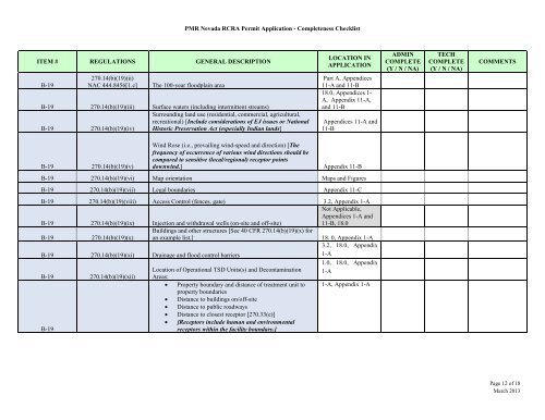
ITEM # REGULATIONS GENERAL DESCRIPTION B-19 270.14(b)(19)(ii) NAC 444.8456[1.c] The 100-year floodplain area PMR Nevada RCRA Permit Application - Completeness Checklist B-19 270.14(b)(19)(iii) Surface waters (including intermittent streams) Surrounding land use (residential, commercial, agricultural, recreational) [Include considerations of EJ issues or National B-19 270.14(b)(19)(iv) Historic Preservation Act (especially Indian lands] B-19 270.14(b)(19)(v) LOCATION IN APPLICATION Part A, Appendices 11-A and 11-B 18.0, Appendices 1- A, Appendix 11-A, and 11-B Appendices 11-A and 11-B Wind Rose (i.e., prevailing wind-speed and direction) [The frequency of occurrence of various wind directions should be compared to sensitive (local/regional) receptor points downwind.] Appendix 11-B B-19 270.14(b)(19)(vi) Map orientation Maps and Figures B-19 270.14(b)(19)(vii) Legal boundaries Appendix 11-C B-19 270.14(b)(19)(viii) Access Control (fences, gate) 3.2, Appendix 1-A Not Applicable, Appendices 1-A and B-19 270.14(b)(19)(ix) Injection and withdrawal wells (on-site and off-site) Buildings and other structures [See 40 CFR 270.14(b)(19)(x) for 11-B, 18.0 B-19 270.14(b)(19)(x) an example list.] 18. 0, Appendix 1-A 3.2, 18.0, Appendix B-19 270.14(b)(19)(xi) Drainage and flood control barriers 1-A 1.0, 18.0, Appendix B-19 270.14(b)(19)(xii) Location of Operational TSD Units(s) and Decontamination Areas: 1-A • Property boundary and distance of treatment unit to property boundaries 1-A, Appendix 1-A • Distance to buildings on/off-site • Distance to public roadways • Distance to closest receptor [270.33(e)] • [Receptors include human and environmental B-19 receptors within the facility boundary.] ADMIN COMPLETE (Y / N / NA) TECH COMPLETE (Y / N / NA) COMMENTS Page 12 of 18 March 2013
- Page 1 and 2: Precious Metals Recovery LLC RCRA P
- Page 3 and 4: ITEM # REGULATIONS GENERAL DESCRIPT
- Page 5 and 6: ITEM # REGULATIONS GENERAL DESCRIPT
- Page 7 and 8: PMR Nevada RCRA Permit Application
- Page 9 and 10: PMR Nevada RCRA Permit Application
- Page 11: ITEM # REGULATIONS GENERAL DESCRIPT
- Page 15 and 16: ITEM # REGULATIONS GENERAL DESCRIPT
- Page 17 and 18: ITEM # REGULATIONS GENERAL DESCRIPT
- Page 19 and 20: M-3 M-3 ITEM # REGULATIONS GENERAL
- Page 21 and 22: OMB# 2050-0024; Expires ___________
- Page 23 and 24: EPA ID Number OMB#: 2050-0024; Expi
- Page 25 and 26: EPA ID Number ADDENDUM TO THE SITE
- Page 27 and 28: EPA ID Number OMB#: 2050-0024; Expi
- Page 29 and 30: EPA ID Number OMB#: 2050-0024; Expi
- Page 31 and 32: EPA ID Number OMB#: 2050-0024; Expi
- Page 33 and 34: This document is for reference purp
- Page 35 and 36: A B C D E F $$W ATERMARKD$$ N 4,475
- Page 37 and 38: Precious Metals Recovery LLC Dry Hi
- Page 39 and 40: 3.2 Barrier and Means to Control En
- Page 41 and 42: 19.0 APPROVAL OF PETITION FOR EXTEN
- Page 43 and 44: LIST OF TABLES Table 1.2-1 Secondar
- Page 45 and 46: Figure 23.1-1 Decomposition & Waste
- Page 47 and 48: Section 10 Appendices 10-A Figures
- Page 49 and 50: HVAC Heating, Ventilation, and Air
- Page 51 and 52: GLOSSARY OF SELECTED TERMS [Authori
- Page 53 and 54: INTRODUCTION Precious Metals Recove
- Page 55 and 56: Pre-application Public Meeting - 40
- Page 57 and 58: (Purity ≥ 99.5%, Directly Stored)
- Page 59 and 60: Administration (MSHA) document, Con
- Page 61 and 62: Fire Doors/Emergency Exit Doors Pr
ITEM # REGULATIONS GENERAL DESCRIPTION<br />
B-19<br />
270.14(b)(19)(ii)<br />
NAC 444.8456[1.c] The 100-year floodplain area<br />
PMR Nevada <strong>RCRA</strong> <strong>Permit</strong> <strong>Application</strong> - Completeness Checklist<br />
B-19 270.14(b)(19)(iii) Surface waters (including intermittent streams)<br />
Surrounding land use (residential, commercial, agricultural,<br />
recreational) [Include considerations of EJ issues or National<br />
B-19 270.14(b)(19)(iv) Historic Preservation Act (especially Indian lands]<br />
B-19 270.14(b)(19)(v)<br />
LOCATION IN<br />
APPLICATION<br />
Part A, Appendices<br />
11-A and 11-B<br />
18.0, Appendices 1-<br />
A, Appendix 11-A,<br />
and 11-B<br />
Appendices 11-A and<br />
11-B<br />
Wind Rose (i.e., prevailing wind-speed and direction) [The<br />
frequency of occurrence of various wind directions should be<br />
compared to sensitive (local/regional) receptor points<br />
downwind.] Appendix 11-B<br />
B-19 270.14(b)(19)(vi) Map orientation Maps and Figures<br />
B-19 270.14(b)(19)(vii) Legal boundaries Appendix 11-C<br />
B-19 270.14(b)(19)(viii) Access Control (fences, gate) 3.2, Appendix 1-A<br />
Not Applicable,<br />
Appendices 1-A and<br />
B-19 270.14(b)(19)(ix) Injection and withdrawal wells (on-site and off-site)<br />
Buildings and other structures [See 40 CFR 270.14(b)(19)(x) for<br />
11-B, 18.0<br />
B-19 270.14(b)(19)(x) an example list.] 18. 0, Appendix 1-A<br />
3.2, 18.0, Appendix<br />
B-19 270.14(b)(19)(xi) Drainage and flood control barriers<br />
1-A<br />
1.0, 18.0, Appendix<br />
B-19 270.14(b)(19)(xii)<br />
Location of Operational TSD Units(s) and Decontamination<br />
Areas:<br />
1-A<br />
• Property boundary and distance of treatment unit to<br />
property boundaries<br />
1-A, Appendix 1-A<br />
• Distance to buildings on/off-site<br />
• Distance to public roadways<br />
• Distance to closest receptor [270.33(e)]<br />
• [Receptors include human and environmental<br />
B-19<br />
receptors within the facility boundary.]<br />
ADMIN<br />
COMPLETE<br />
(Y / N / NA)<br />
TECH<br />
COMPLETE<br />
(Y / N / NA)<br />
COMMENTS<br />
Page 12 of 18<br />
March 2013


