No. 237 Maritime Archaeology in the People's Republic of China ...
No. 237 Maritime Archaeology in the People's Republic of China ...
No. 237 Maritime Archaeology in the People's Republic of China ...

You also want an ePaper? Increase the reach of your titles
YUMPU automatically turns print PDFs into web optimized ePapers that Google loves.
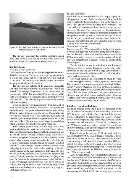
Figure 102. Bai Jiao. The wreck site is located at <strong>the</strong> base <strong>of</strong> <strong>the</strong> reef<br />
<strong>in</strong> <strong>the</strong> foreground (CHI/95/144).<br />
The site was visited each day from <strong>the</strong> expedition base at<br />
Xiao Chen us<strong>in</strong>g a local fish<strong>in</strong>g boat that acted as <strong>the</strong> dive<br />
platform. It was a 30 to 40 m<strong>in</strong>ute journey each way.<br />
Site description<br />
we at h e r a n d S e a C o n d i t i o n S<br />
The D<strong>in</strong>ghai area is usually affected by <strong>the</strong> typhoon <strong>in</strong> summer,<br />
that is July and August. The monsoon from <strong>the</strong> north-east comes<br />
<strong>in</strong> w<strong>in</strong>ter and spr<strong>in</strong>g, and <strong>the</strong> w<strong>in</strong>d and waves are weakest<br />
at this time. The sou<strong>the</strong>rly w<strong>in</strong>d usually comes <strong>in</strong> summer<br />
br<strong>in</strong>g<strong>in</strong>g with it <strong>of</strong>ten violent waves.<br />
The direction and velocity <strong>of</strong> <strong>the</strong> current is changeable<br />
and affected by <strong>the</strong> tide. Generally, <strong>the</strong> speed is 1 metre per<br />
second. The average temperature <strong>of</strong> <strong>the</strong> surface water is<br />
approximately 20°C. The lowest is <strong>in</strong> February, between 8˚C<br />
and 9˚C, and highest is <strong>in</strong> summer (August) generally between<br />
27˚C and 28˚C. The visibility is generally better <strong>in</strong> summer<br />
and worst <strong>in</strong> spr<strong>in</strong>g.<br />
W<strong>in</strong>ds on <strong>the</strong> site were predom<strong>in</strong>antly from <strong>the</strong> south or<br />
north-east dur<strong>in</strong>g <strong>the</strong> season <strong>of</strong> excavation. Occasionally <strong>the</strong><br />
sou<strong>the</strong>rly would br<strong>in</strong>g ra<strong>in</strong> and conditions that made div<strong>in</strong>g<br />
difficult. <strong>No</strong>r<strong>the</strong>rlies were generally warmer. The wea<strong>the</strong>r was<br />
very variable, rang<strong>in</strong>g from warm and humid through to wet<br />
and cool. Quite strong w<strong>in</strong>ds developed from <strong>the</strong> mid to <strong>the</strong><br />
latter part <strong>of</strong> June. These w<strong>in</strong>ds created sloppy sea conditions<br />
which sometimes prevented work on <strong>the</strong> wreck site.<br />
Tidal change <strong>of</strong>ten affected <strong>the</strong> visibility and it was<br />
particularly difficult to work just before slack water. A large<br />
tidal range (7 metres) created a reasonably strong current along<br />
<strong>the</strong> site. The current could be used to advantage to carry away<br />
sediment dur<strong>in</strong>g hand fann<strong>in</strong>g and excavation. Turbulence was<br />
created when water came over <strong>the</strong> reef to <strong>the</strong> north <strong>of</strong> <strong>the</strong> site<br />
as <strong>the</strong> tide approached its highest level, periodically affect<strong>in</strong>g<br />
visibility. Visibility ranged from 0.5 metres to 3 metres. Neap<br />
and spr<strong>in</strong>g tides were also <strong>in</strong>fluential <strong>in</strong> work<strong>in</strong>g on <strong>the</strong> site,<br />
fur<strong>the</strong>r <strong>in</strong>creas<strong>in</strong>g <strong>the</strong> tidal range. Low tide tended to give<br />
<strong>the</strong> best visibility, probably aided by <strong>in</strong>creased light from <strong>the</strong><br />
surface. Visibility was also affected by sand dredg<strong>in</strong>g <strong>in</strong> <strong>the</strong><br />
area. On occasion <strong>the</strong> excavation team arrived at Bai Jiao 1<br />
to discover dredger slurry had flowed right across <strong>the</strong> site <strong>in</strong><br />
a cloud, reduc<strong>in</strong>g visibility to zero. A moor<strong>in</strong>g buoy for <strong>the</strong><br />
work boat was attached to <strong>the</strong> large concretion <strong>in</strong> grid square<br />
OG4 (refer to Figure 9).<br />
68<br />
Se a-b e d C o m P o S i t i o n<br />
The wreck site is situated at <strong>the</strong> base <strong>of</strong> a steeply slop<strong>in</strong>g reef<br />
<strong>of</strong> jagged igneous rock. At <strong>the</strong> <strong>in</strong>terface with <strong>the</strong> sea-bed <strong>the</strong><br />
rock is fractured <strong>in</strong>to regular shapes. The sea-bed comprises<br />
sand, shell grit and easily disturbed f<strong>in</strong>e sediments. This<br />
composition <strong>of</strong> materials overlies a substrate <strong>of</strong> viscous grey/<br />
green clay-like mud. The viscous and clay-like condition <strong>of</strong><br />
<strong>the</strong> mud suggests <strong>the</strong> subsurface environment is anaerobic. An<br />
exception to this is likely to occur where <strong>the</strong> passages <strong>of</strong> mar<strong>in</strong>e<br />
worms carry oxygenated water and this may effect artefact<br />
materials encountered dur<strong>in</strong>g burrow<strong>in</strong>g. The overly<strong>in</strong>g sand<br />
is likely to be an aerobic environment.<br />
Ge n e r a l o b S e rvat i o n S<br />
The work site for 1995 extended along <strong>the</strong> base <strong>of</strong> a steeply<br />
slop<strong>in</strong>g block reef wall which runs along <strong>the</strong> north part <strong>of</strong><br />
<strong>the</strong> site. The site covers a 30 metre by 6 metre area (if <strong>the</strong><br />
1990 survey and excavation is taken <strong>in</strong>to account), although<br />
<strong>the</strong>re is a concentration <strong>of</strong> rema<strong>in</strong>s toward <strong>the</strong> middle <strong>of</strong> <strong>the</strong><br />
artefact spread.<br />
The site itself is located <strong>in</strong> a depth <strong>of</strong> water that varies<br />
between 6 and 13 metres depend<strong>in</strong>g on <strong>the</strong> tide. Initial<br />
<strong>in</strong>spection <strong>of</strong> <strong>the</strong> site discovered a large concentration <strong>of</strong><br />
artefact material was located east <strong>of</strong> <strong>the</strong> concretion identified<br />
<strong>in</strong> <strong>the</strong> work undertaken <strong>in</strong> 1990.<br />
The wreck rema<strong>in</strong>s are dom<strong>in</strong>ated by <strong>the</strong>se two iron<br />
concretions (approximately 1.5 metres square by 1 metre high).<br />
They lie some 2 metres apart and are jo<strong>in</strong>ed by a s<strong>in</strong>gle baulk <strong>of</strong><br />
timber. A number <strong>of</strong> ceramic bowls are partly encapsulated <strong>in</strong><br />
<strong>the</strong> concretions. Separate small concretions also engulf ceramic<br />
bowls. The rema<strong>in</strong>der <strong>of</strong> <strong>the</strong> site comprised concentrations<br />
<strong>of</strong> bowls many <strong>of</strong> which rema<strong>in</strong> stacked toge<strong>the</strong>r. There are<br />
isolated scattered bowls among <strong>the</strong> rocks and down <strong>the</strong> sand<br />
slope which forms <strong>the</strong> boundary <strong>of</strong> <strong>the</strong> site.<br />
Initial survey and methodology<br />
The <strong>in</strong>itial location <strong>of</strong> <strong>the</strong> site <strong>in</strong> 1995 was hampered by <strong>the</strong><br />
lack <strong>of</strong> transits photographs or <strong>the</strong> availability <strong>of</strong> accurate<br />
GPS location. Low visibility also complicated <strong>the</strong> circular<br />
survey conducted <strong>in</strong> <strong>the</strong> approximate site vic<strong>in</strong>ity. However,<br />
after several attempts <strong>the</strong> large identify<strong>in</strong>g concretion (2x2x1<br />
metres) from 1990 was located. Surface survey showed that<br />
<strong>the</strong> 1990 area <strong>of</strong> work was relatively sterile. The general area<br />
<strong>of</strong> survey extended <strong>in</strong> an easterly direction 18 metres and <strong>in</strong><br />
a north-south direction over 6 metres.<br />
Figure 8 shows <strong>the</strong> previous 1990 site work and grid<br />
system, toge<strong>the</strong>r with <strong>the</strong> <strong>in</strong>tended area <strong>of</strong> excavation, drawn<br />
after <strong>in</strong>itial <strong>in</strong>spection <strong>in</strong> 1995. The decision was made to<br />
cont<strong>in</strong>ue us<strong>in</strong>g a 2x2 metre grid system started <strong>in</strong> 1990 and<br />
extend this along to <strong>the</strong> eastern part <strong>of</strong> <strong>the</strong> site. The large<br />
concretion with a timber extend<strong>in</strong>g from it which had been<br />
used as <strong>the</strong> zero datum <strong>in</strong> <strong>the</strong> 1990 work was aga<strong>in</strong> used for<br />
<strong>the</strong> 1995 excavation work.<br />
A 2x2 metre grid frame was constructed and a basel<strong>in</strong>e laid<br />
that cont<strong>in</strong>ued <strong>the</strong> 245˚ east-west orientation <strong>of</strong> <strong>the</strong> previous<br />
basel<strong>in</strong>e from 1990. A second basel<strong>in</strong>e was <strong>the</strong>n laid 2 metres to<br />
<strong>the</strong> north <strong>of</strong> this to aid <strong>the</strong> accurate placement <strong>of</strong> <strong>the</strong> moveable<br />
grid frame. The record<strong>in</strong>g method followed a simple number<strong>in</strong>g<br />
system identify<strong>in</strong>g parallel and perpendicular reference to <strong>the</strong><br />
primary basel<strong>in</strong>e. The letter ‘G’ was imposed as represent<strong>in</strong>g