Central Valley Aquifer, Chapters A and B - MAE Class Websites
Central Valley Aquifer, Chapters A and B - MAE Class Websites Central Valley Aquifer, Chapters A and B - MAE Class Websites
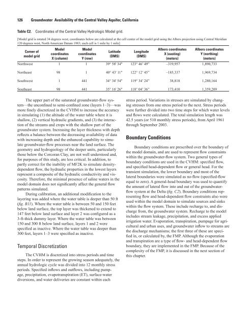
126 Groundwater Availability of the Central Valley Aquifer, California Table C2. Coordinates of the Central Valley Hydrologic Model grid. Corner of model grid Model coordinates X (column) - - - for purposes of this study, are less critical. In addition, to - patterns simulated. ( Temporal Discretization Model coordinates Y (row) Latitude (DMS) - Longitude (DMS) - Boundary Conditions Albers coordinates X (easting) (meters) Albers coordinates Y (northing) (meters) 1 1 1,890,733 Northeast 98 1 1,969,734 1 441 38,818 1,280,164 98 441 173,410 1,359,209 - - - - this chapter.
0 Suisun Bay 50 100 Miles 0 50 100 Kilometers Shaded relief derived from U.S. Geological Survey National Elevation Dataset, 2006. Albers Equal Area Conic Projection 1 3 2 6 4 5 9 7 8 11 10 12 13 12 14 EXPLANATION Model stream cell Model general-head boundary cell Active model boundary Water-balance subregion receiving non-routed deliveries Diversion location Inflow location Model Development 127 California Department of Water Resources water-balance subregions and identifier Figure C2. Distribution of general-head boundary cells and major streams and canals with streamflow-routing cells (including location of inflows and diversions). The water-balance subregions are described in . 16 15 19 17 18 20 21
- Page 94 and 95: 76 Groundwater Availability of the
- Page 96 and 97: 78 Groundwater Availability of the
- Page 98 and 99: 80 Groundwater Availability of the
- Page 100 and 101: 82 Groundwater Availability of the
- Page 102 and 103: 84 Groundwater Availability of the
- Page 104 and 105: 86 Groundwater Availability of the
- Page 106 and 107: 88 Groundwater Availability of the
- Page 108 and 109: 90 Groundwater Availability of the
- Page 110 and 111: 92 Groundwater Availability of the
- Page 112 and 113: 94 Groundwater Availability of the
- Page 114 and 115: 96 Groundwater Availability of the
- Page 116 and 117: 98 Groundwater Availability of the
- Page 118 and 119: 100 Groundwater Availability of the
- Page 120 and 121: 102 Groundwater Availability of the
- Page 122 and 123: 104 Groundwater Availability of the
- Page 124 and 125: 106 Groundwater Availability of the
- Page 126 and 127: 108 Groundwater Availability of the
- Page 128 and 129: 110 Groundwater Availability of the
- Page 130 and 131: 112 Groundwater Availability of the
- Page 132 and 133: 114 Groundwater Availability of the
- Page 134 and 135: 116 Groundwater Availability of the
- Page 136 and 137: 118 Groundwater Availability of the
- Page 138 and 139: 120 Groundwater Availability of the
- Page 140 and 141: 122 Groundwater Availability of the
- Page 142 and 143: 124 Groundwater Availability of the
- Page 146 and 147: 128 Groundwater Availability of the
- Page 148 and 149: 130 Groundwater Availability of the
- Page 150 and 151: 132 Groundwater Availability of the
- Page 152 and 153: 134 Groundwater Availability of the
- Page 154 and 155: 136 Groundwater Availability of the
- Page 156 and 157: 138 Groundwater Availability of the
- Page 158 and 159: 140 Groundwater Availability of the
- Page 160 and 161: 142 Groundwater Availability of the
- Page 162 and 163: 144 Groundwater Availability of the
- Page 164 and 165: 146 Groundwater Availability of the
- Page 166 and 167: 148 Groundwater Availability of the
- Page 168 and 169: 150 Groundwater Availability of the
- Page 170 and 171: 152 Groundwater Availability of the
- Page 172 and 173: 154 Groundwater Availability of the
- Page 174 and 175: 156 Groundwater Availability of the
- Page 176 and 177: 158 Groundwater Availability of the
- Page 178 and 179: 160 Groundwater Availability of the
- Page 180 and 181: 162 Groundwater Availability of the
- Page 182 and 183: 164 Groundwater Availability of the
- Page 184 and 185: 166 Groundwater Availability of the
- Page 186 and 187: 168 Groundwater Availability of the
- Page 188 and 189: 170 Groundwater Availability of the
- Page 190 and 191: 172 Groundwater Availability of the
- Page 192 and 193: 174 Groundwater Availability of the
126 Groundwater Availability of the <strong>Central</strong> <strong>Valley</strong> <strong>Aquifer</strong>, California<br />
Table C2. Coordinates of the <strong>Central</strong> <strong>Valley</strong> Hydrologic Model grid.<br />
<br />
<br />
Corner of<br />
model grid<br />
Model<br />
coordinates<br />
X (column)<br />
-<br />
<br />
<br />
<br />
-<br />
<br />
<br />
<br />
-<br />
<br />
<br />
<br />
for purposes of this study, are less critical. In addition, to<br />
<br />
<br />
-<br />
<br />
<br />
patterns simulated.<br />
<br />
<br />
(<br />
<br />
<br />
<br />
<br />
<br />
<br />
Temporal Discretization<br />
Model<br />
coordinates<br />
Y (row)<br />
Latitude<br />
(DMS)<br />
<br />
<br />
<br />
-<br />
<br />
<br />
Longitude<br />
(DMS)<br />
-<br />
<br />
<br />
<br />
<br />
<br />
Boundary Conditions<br />
Albers coordinates<br />
X (easting)<br />
(meters)<br />
Albers coordinates<br />
Y (northing)<br />
(meters)<br />
1 1 1,890,733<br />
Northeast 98 1 1,969,734<br />
1 441 38,818 1,280,164<br />
98 441 173,410 1,359,209<br />
<br />
<br />
<br />
<br />
<br />
<br />
<br />
<br />
<br />
-<br />
<br />
<br />
-<br />
<br />
<br />
-<br />
<br />
-<br />
<br />
<br />
<br />
<br />
this chapter.


