Landform identification chart
Landform identification chart Landform identification chart
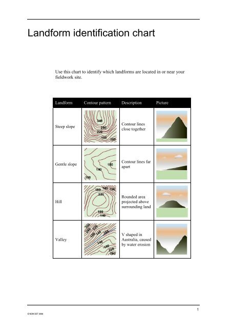
Landform identification chart © NSW DET 2006 Use this chart to identify which landforms are located in or near your fieldwork site. Landform Contour pattern Description Picture Steep slope Gentle slope Hill Valley Contour lines close together Contour lines far apart Rounded area projected above surrounding land V shaped in Australia, caused by water erosion 1
<strong>Landform</strong> <strong>identification</strong> <strong>chart</strong><br />
© NSW DET 2006<br />
Use this <strong>chart</strong> to identify which landforms are located in or near your<br />
fieldwork site.<br />
<strong>Landform</strong> Contour pattern Description Picture<br />
Steep slope<br />
Gentle slope<br />
Hill<br />
Valley<br />
Contour lines<br />
close together<br />
Contour lines far<br />
apart<br />
Rounded area<br />
projected above<br />
surrounding land<br />
V shaped in<br />
Australia, caused<br />
by water erosion<br />
1
© NSW DET 2006<br />
Ridge<br />
Creek<br />
Spur<br />
Saddle<br />
Cliff<br />
Shoreline<br />
Headland<br />
Long narrow<br />
continuous<br />
elevation<br />
Marked by blue<br />
line, contours<br />
indicate direction<br />
of flow<br />
Subsidiary<br />
summit of a<br />
mountain, lower<br />
than the summit<br />
of the mountain<br />
but connected by<br />
a ridge<br />
Two hills with a<br />
dip in between<br />
Rock face<br />
exposes a clear<br />
vertical drop in<br />
height<br />
Fringe of land at<br />
edge of large<br />
water body eg:<br />
ocean, sea, lake<br />
Large area<br />
surrounded by<br />
water on 3 sides,<br />
rocky due to<br />
exposure and<br />
weathering<br />
2


