The Role of Downhole Measurements in Marine Geology and ...
The Role of Downhole Measurements in Marine Geology and ...
The Role of Downhole Measurements in Marine Geology and ...

Create successful ePaper yourself
Turn your PDF publications into a flip-book with our unique Google optimized e-Paper software.
THE ROLE OF DOWN HOLE MEASUREMENTS IN MARIN E<br />
GEOLOGY AN D GEOPHYSICS<br />
David Goldberg<br />
Borehole Research Group, Lamont-Doherty Earth<br />
Observatory, Palisades, New York<br />
Abstract. Dur<strong>in</strong>g the last 25 years, downhole measure- core data with regional geophysical surveys <strong>and</strong> <strong>in</strong> proments<br />
have been <strong>in</strong>creas<strong>in</strong>gly used for scientific applica- vid<strong>in</strong>g data where core sections could not be obta<strong>in</strong>ed.<br />
tions <strong>in</strong> mar<strong>in</strong>e geology <strong>and</strong> geophysics, particularly <strong>in</strong> Examples <strong>of</strong> recent scientific applications <strong>and</strong> apdeep-sea<br />
drill<strong>in</strong>g operations. Used mostly by the oil proaches are presented that address previous problems<br />
<strong>in</strong>dustry to map promis<strong>in</strong>g formations for exploration with data quality <strong>and</strong> changes <strong>in</strong> properties over time<br />
<strong>and</strong> production <strong>of</strong> hydrocarbons, a variety <strong>of</strong> <strong>in</strong>stru- after a hole is drilled. <strong>The</strong> role <strong>of</strong> downhole measurements<br />
have been developed that can be lowered down ments is discussed for two broad areas <strong>of</strong> research: the<br />
drill holes to extract <strong>in</strong>formation about the subsurface structure <strong>and</strong> composition <strong>of</strong> the Earth's crust, most <strong>of</strong><br />
geology. In the last decade, advances <strong>in</strong> computers, which is formed at mid-ocean ridges, <strong>and</strong> past changes <strong>in</strong><br />
s<strong>of</strong>tware, <strong>and</strong> data transmission have greatly <strong>in</strong>creased Earth's environment recorded <strong>in</strong> the deep-sea sediments<br />
the amount <strong>and</strong> quality <strong>of</strong> data that such <strong>in</strong>struments can overly<strong>in</strong>g the crust. F<strong>in</strong>ally, new emerg<strong>in</strong>g technologies<br />
provide. Relatively new <strong>in</strong>struments that image the bore- <strong>and</strong> experiments that promise significant advantages<br />
hole wall with high resolution can reveal layers <strong>and</strong> over current methods for downhole measurements <strong>in</strong><br />
faults that previously could be seen only <strong>in</strong> core sections. mar<strong>in</strong>e geology <strong>and</strong> geophysics are discussed.<br />
<strong>Downhole</strong> measurements play a crucial role <strong>in</strong> l<strong>in</strong>k<strong>in</strong>g<br />
INTRODUCTION<br />
<strong>The</strong> scientific use <strong>of</strong> downhole measurements <strong>in</strong> ma-<br />
r<strong>in</strong>e geology <strong>and</strong> geophysics has become <strong>in</strong>creas<strong>in</strong>gly<br />
important <strong>in</strong> recent years. <strong>The</strong> methods <strong>and</strong> tools are<br />
derived largely from those developed for oil <strong>and</strong> gas<br />
exploration <strong>and</strong> are applied to recent scientific problems<br />
<strong>in</strong> the Earth's' oceans. <strong>The</strong> purpose <strong>of</strong> this review is<br />
use <strong>of</strong> logg<strong>in</strong>g is due to several causes, <strong>in</strong>clud<strong>in</strong>g permanent<br />
shipboard systems for rout<strong>in</strong>e operations, vast improvements<br />
<strong>in</strong> downhole <strong>in</strong>strumentation technology<br />
<strong>and</strong> drill<strong>in</strong>g methods, <strong>and</strong> new measurements made on<br />
core samples that allow for one-to-one correlation with<br />
similar measurements made downhole.<br />
<strong>The</strong>re have been numerous published discussions <strong>of</strong><br />
the scientific goals <strong>and</strong> overviews <strong>of</strong> DSDP <strong>and</strong> ODP<br />
tw<strong>of</strong>old: first, to present applications <strong>of</strong> state-<strong>of</strong>-the-art that <strong>in</strong>clude elements <strong>of</strong> specific downhole measurement<br />
downhole measurements <strong>in</strong> recent mar<strong>in</strong>e science prob- capabilities, their successes, <strong>and</strong> their failures. For genlems,<br />
<strong>and</strong> second, to review both exist<strong>in</strong>g <strong>and</strong> new meth- eral <strong>and</strong> historical background <strong>of</strong> the DSDP <strong>and</strong> ODP,<br />
odologies for downhole measurements with new scien- the <strong>in</strong>terested reader is referred to Revelle [1981] <strong>and</strong> the<br />
tific directions. Dur<strong>in</strong>g the last 25 years, the Deep-Sea proceed<strong>in</strong>gs <strong>of</strong> the International Conference on Scien-<br />
Drill<strong>in</strong>g Project (DSDP) <strong>and</strong> its successor s<strong>in</strong>ce 1984, the tific Ocean Drill<strong>in</strong>g (COSOD) <strong>in</strong> 1987 [Jo<strong>in</strong>t Oceano-<br />
Ocean Drill<strong>in</strong>g Program (ODP), have been progressively graphic Institutions for Deep Earth Sampl<strong>in</strong>g <strong>and</strong> Jo<strong>in</strong>t<br />
exp<strong>and</strong><strong>in</strong>g the role <strong>of</strong> downhole measurements. <strong>The</strong>se Oceanographic Institutions, Inc., 1987]. For more deprograms<br />
have successfully fulfilled their scientific mis- tailed <strong>in</strong>formation on specific drill<strong>in</strong>g locations, the Inisions<br />
by drill<strong>in</strong>g holes <strong>in</strong> nearly all the different geologic tial Reports <strong>and</strong> Scientific Results <strong>of</strong> the ODP <strong>and</strong><br />
sett<strong>in</strong>gs <strong>of</strong> the world's oceans. A total <strong>of</strong> 170 drill<strong>in</strong>g DSDP <strong>of</strong>fer summaries, <strong>and</strong> various monographs <strong>of</strong> the<br />
expeditions, or "legs," around the world's oceans have American Geophysical Union present synthesis articles<br />
been successfully completed at the time <strong>of</strong> this writ<strong>in</strong>g. for sites around the globe. For a more detailed discus-<br />
More than 1000 drill holes have been cored, after which sion <strong>of</strong> particular downhole measurements, a number <strong>of</strong><br />
many have <strong>in</strong> turn been logged us<strong>in</strong>g downhole <strong>in</strong>stru- smaller proceed<strong>in</strong>gs outl<strong>in</strong>e various specific applications<br />
ments. While downhole measurements were conducted [e.g., Worth<strong>in</strong>gton et al., 1987; Hyndman, 1991; Cullen,<br />
<strong>in</strong> less than 14% <strong>of</strong> all mar<strong>in</strong>e holes drilled dur<strong>in</strong>g the 1994]. Reviews <strong>of</strong> current downhole technologies are<br />
DSDP, they have been made <strong>in</strong> more than 56% <strong>of</strong> the also periodically published <strong>in</strong> <strong>in</strong>dustry journals [e.g.,<br />
holes drilled by ODP. This dramatic <strong>in</strong>crease <strong>in</strong> ODP's Snyder <strong>and</strong> Flem<strong>in</strong>g, 1985; Prensky, 1994].<br />
Copyright 1997 by the American Geophysical Union.<br />
8755-1209/97/97 RG-00221 $15.00<br />
e315e<br />
Reviews <strong>of</strong> Geophysics, 35, 3 / August 1997<br />
pages 31 5-342<br />
Paper number 97RG00221
31 6 ß Goldberg: DOWNHOLE MEASUREMENTS 35, 3 / REVIEWS OF GEOPHYSICS<br />
Cont<strong>in</strong>ental scientific drill<strong>in</strong>g programs have also suc- "an ODP borehole is a scientific legacy; it is not a mere<br />
cessfully used downhole measurements to achieve their relic <strong>of</strong> a core acquisition procedure. Scientific measureobjectives.<br />
<strong>Downhole</strong> experiments support <strong>and</strong> enhance ments <strong>in</strong> boreholes <strong>and</strong> on recovered core should be<br />
core-related studies <strong>of</strong> the subsurface <strong>in</strong> almost every planned on the basis <strong>of</strong> their <strong>in</strong>corporation <strong>in</strong>to a reenvironment<br />
<strong>and</strong> <strong>in</strong> nearly every scientific discipl<strong>in</strong>e. gional or global model, their future re<strong>in</strong>terpretation <strong>and</strong>,<br />
Dur<strong>in</strong>g the last decade, several cont<strong>in</strong>ental scientific <strong>in</strong> some cases, the reoccupation <strong>of</strong> the drill site for<br />
drill<strong>in</strong>g programs conducted by Germany, Japan, Swe- further <strong>in</strong>vestigations." Given these views <strong>of</strong> the future,<br />
den, the United States, Russia, <strong>and</strong> Ukra<strong>in</strong>e have relied the summary provided here <strong>of</strong> recent scientific applicaon<br />
the extensive use <strong>of</strong> downhole measurements tions <strong>and</strong> new methods for downhole measurements<br />
[Zoback et al., 1994]. Often the results <strong>of</strong> these efforts leads to the conclusion that downhole data are irreplacecomplement<br />
the goals <strong>of</strong> the ODP <strong>in</strong> advanc<strong>in</strong>g new able assets <strong>in</strong> mar<strong>in</strong>e geology <strong>and</strong> geophysics; plann<strong>in</strong>g<br />
scientific applications <strong>of</strong> downhole measurements, <strong>and</strong> <strong>and</strong> use <strong>of</strong> downhole experiments <strong>in</strong> the future should<br />
together, these programs are mov<strong>in</strong>g researchers toward exp<strong>and</strong>, both while drill<strong>in</strong>g <strong>and</strong> <strong>in</strong> exist<strong>in</strong>g holes. <strong>The</strong><br />
a global scientific <strong>in</strong>vestigation us<strong>in</strong>g downhole <strong>in</strong>stru- scientific legacy <strong>of</strong> new downhole data will undoubtedly<br />
ments to measure <strong>in</strong> situ properties <strong>of</strong> the Earth. cont<strong>in</strong>ue to advance mar<strong>in</strong>e science <strong>in</strong> several disci-<br />
<strong>The</strong> scope <strong>of</strong> this review focuses on past, present, <strong>and</strong><br />
future scientific applications that have used or will use<br />
"short-term" experiments, that is, measurements that<br />
pl<strong>in</strong>es.<br />
themselves do not require <strong>in</strong>struments to be deployed<br />
for more than several hours or days <strong>in</strong> the subseafloor.<br />
BACKGROUND<br />
Such measurements can be repeated over longer periods Dur<strong>in</strong>g the previous decade, downhole measurements<br />
for time series studies. This class <strong>of</strong> downhole measure- have become viewed as essential <strong>and</strong> complementary to<br />
ments is commonly referred to as "logg<strong>in</strong>g" <strong>and</strong> is dis- measurements made on recovered core. <strong>The</strong>y are critical<br />
t<strong>in</strong>ct from the class <strong>of</strong> <strong>in</strong>struments deployed below the for measurements, such as temperature, that must be<br />
seafloor for long-term studies. <strong>The</strong> latter class may be made <strong>in</strong> situ. <strong>The</strong> scientific objectives at most study sites<br />
referred to as <strong>in</strong> situ "observatories" <strong>and</strong> is discussed <strong>in</strong> are addressed with a multidiscipl<strong>in</strong>ary strategy, <strong>in</strong>tegratless<br />
detail (the reader is referred to recent workshop <strong>in</strong>g measurements made on core samples with those<br />
reports by Hyndman [1991] <strong>and</strong> Carson et al. [1994] for made downhole <strong>and</strong> plac<strong>in</strong>g both <strong>in</strong> the context <strong>of</strong> rean<br />
overview <strong>of</strong> <strong>and</strong> further references to a variety <strong>of</strong> gional geophysical <strong>and</strong> seismic studies. Worth<strong>in</strong>gton et al.<br />
downhole observatory applications <strong>in</strong> mar<strong>in</strong>e research). [1991] summarize this multiscale approach to drill<strong>in</strong>g<br />
<strong>The</strong> reason for this dist<strong>in</strong>ction is methodological, not <strong>in</strong>vestigations <strong>and</strong> suggest that data <strong>in</strong>tegration will be<br />
scientific, as both types <strong>of</strong> deployments are complemen- the hallmark <strong>of</strong> the geosciences <strong>in</strong> the 1990s. Figure 1<br />
tary. <strong>The</strong> short-term logg<strong>in</strong>g measurements that are pri- shows their illustration <strong>of</strong> the range <strong>of</strong> experimental<br />
marily addressed <strong>in</strong>clude (1) measurements made <strong>in</strong> a scales <strong>of</strong> <strong>in</strong>vestigation used today. <strong>The</strong> multiple scales <strong>of</strong><br />
borehole by <strong>in</strong>struments lowered on a wirel<strong>in</strong>e, (2) mea- <strong>in</strong>vestigation used with seismic, downhole, <strong>and</strong> core data<br />
surements made while drill<strong>in</strong>g, <strong>and</strong> (3) measurements acquired <strong>in</strong> the same geological environment complerepeated<br />
over time. A short background is given first to ment each other extremely well. Seismic sections are the<br />
def<strong>in</strong>e the current types <strong>and</strong> range <strong>of</strong> measurements that basis for a regional description, downhole measurements<br />
can be made by logg<strong>in</strong>g. <strong>The</strong>n a discussion <strong>of</strong> strategies are <strong>of</strong> an <strong>in</strong>termediate scale <strong>and</strong> give cont<strong>in</strong>uous <strong>in</strong>forfor<br />
downhole measurements is presented, followed by a mation <strong>in</strong> the region surround<strong>in</strong>g the borehole, <strong>and</strong> core<br />
discussion <strong>of</strong> various scientific achievements <strong>of</strong> down- samples provide detailed <strong>in</strong>formation on physical prophole<br />
measurements over the past several years. With<strong>in</strong> erties <strong>and</strong> age. <strong>Downhole</strong>, core, <strong>and</strong> seismic data used<br />
this last section, two broad discipl<strong>in</strong>ary areas are dis- jo<strong>in</strong>tly also contribute to the confidence <strong>in</strong> each <strong>in</strong>dividcussed:<br />
the Earth's crust <strong>and</strong> Earth's environment. <strong>The</strong> ual data set. Unlike measurements on core samples,<br />
applications <strong>of</strong> many different downhole measurements which are <strong>of</strong>ten disturbed dur<strong>in</strong>g the process <strong>of</strong> recovery,<br />
fall <strong>in</strong>to these two categories, both <strong>of</strong> which conta<strong>in</strong> downhole data provide a set <strong>of</strong> cont<strong>in</strong>uous logs <strong>of</strong> <strong>in</strong>forseveral<br />
subdiscipl<strong>in</strong>es that illustrate the broad range <strong>of</strong> mation <strong>and</strong> sample a larger volume <strong>of</strong> rock than core<br />
questions which can be addressed us<strong>in</strong>g downhole meth- measurements. Because logs have much greater vertical<br />
ods.<br />
resolution than surface data but little lateral resolution,<br />
<strong>The</strong> scientific objectives for the future <strong>of</strong> mar<strong>in</strong>e the comb<strong>in</strong>ation <strong>of</strong> the two def<strong>in</strong>es subsurface geological<br />
scientific drill<strong>in</strong>g have recently been outl<strong>in</strong>ed <strong>in</strong> the ODP structures far better than either data type can alone. <strong>The</strong><br />
Long Range Plan [Jo<strong>in</strong>t Oceanographic Institutions, Inc. difference <strong>in</strong> the scale <strong>of</strong> physical phenomena affect<strong>in</strong>g<br />
(JOI), 1996]. This plan describes the directions for ma- each type <strong>of</strong> measurement may be extreme. <strong>The</strong> scale<br />
r<strong>in</strong>e scientific drill<strong>in</strong>g from now through 2008 <strong>and</strong> the ratio from core to log may be greater than 2 x 10³; the<br />
new technologies that will be required to accomplish ratio from log to seismic section may be 106 to 107 times<br />
them. <strong>The</strong> plan relies heavily on downhole experiments larger. In most <strong>in</strong>tegrated scientific applications, thereto<br />
achieve its scientific objectives. It also ma<strong>in</strong>ta<strong>in</strong>s the fore, downhole measurements provide three complehistorical<br />
premise that [Worth<strong>in</strong>gton et al., 1987, p. 135] mentary advantages: (1) data are acquired under <strong>in</strong> situ
35 3 /REVIEWS OF GEOPHYSICS Goldberg: DOWNHOLE MEASUREMENTS ß 317<br />
Figure 1. Schematic diagram illustrat<strong>in</strong>g the different scales <strong>of</strong> measurement <strong>in</strong> geophysics [after Worth<strong>in</strong>gton<br />
et al., 1991]. <strong>The</strong> span <strong>of</strong> measurements from core samples to seismic survey<strong>in</strong>g is greater than 10 4,<br />
complicat<strong>in</strong>g the <strong>in</strong>terpretation <strong>of</strong> data from samples to regional geology without <strong>in</strong>termediate-scale logg<strong>in</strong>g<br />
<strong>and</strong> borehole measurements.<br />
conditions, (2) data are acquired <strong>in</strong> cont<strong>in</strong>uous pr<strong>of</strong>iles<br />
measured throughout the <strong>in</strong>terval with no miss<strong>in</strong>g sections,<br />
<strong>and</strong> (3) data are sampled at a larger scale, <strong>in</strong>termediate<br />
between core <strong>and</strong> seismic measurements. 460<br />
In most drill<strong>in</strong>g environments, cont<strong>in</strong>uous cor<strong>in</strong>g does<br />
not result <strong>in</strong> cont<strong>in</strong>uous core recovery. In fact, core<br />
recovery by techniques other than piston cor<strong>in</strong>g is less 470<br />
than 50% on average, <strong>and</strong> this proportion is <strong>of</strong>ten disturbed<br />
by the drill<strong>in</strong>g process [Hyndman, 1991]. As a<br />
result, the true core depth becomes ambiguous. Drill<strong>in</strong>g 480<br />
disturbances with<strong>in</strong> a recovered section can be cor-<br />
rected, however, by correlation with cont<strong>in</strong>uous logs, so<br />
that preferential recovery <strong>of</strong> particular rock types can be<br />
documented. In Figure 2 a nonrepresentative section <strong>of</strong><br />
<strong>in</strong>terlayered basalt <strong>and</strong> sediment near the Juan de Fuca<br />
490<br />
ridge <strong>in</strong> the northeastern Pacific would have been <strong>in</strong>terpreted<br />
from the recovered core alone, but the cont<strong>in</strong>uous<br />
log pr<strong>of</strong>iles reveal layers <strong>of</strong> sediment between basalt<br />
s00<br />
that were not recovered through cor<strong>in</strong>g. Despite such<br />
successes, complete recovery <strong>of</strong> cont<strong>in</strong>uous log pr<strong>of</strong>iles<br />
is still not possible. With current wirel<strong>in</strong>e technology, the<br />
s0<br />
<strong>in</strong>terval immediately below the seafloor is not logged<br />
because the drill pipe must be lowered 80-100 m to<br />
ensure hole stability <strong>in</strong> the s<strong>of</strong>test sediments for logg<strong>in</strong>g<br />
s20<br />
to beg<strong>in</strong>. To benefit from core-log correlation, the stratigraphic<br />
<strong>in</strong>terpretation from logs is limited to below this<br />
depth <strong>and</strong> only where high-quality data are recorded.<br />
s30<br />
ß<br />
<strong>Downhole</strong> <strong>Measurements</strong>: Logg<strong>in</strong>g<br />
In 1927, C. <strong>and</strong> M. Schlumberger made the first well<br />
log near Paris. It was a simple electrical current experiment<br />
that used an electrode placed at a series <strong>of</strong> horizontal<br />
po<strong>in</strong>ts on the ground to make measurements <strong>and</strong><br />
detect variations <strong>in</strong> geological structure below the sur-<br />
Resistivity Gamma-ray<br />
Intensity<br />
(ohm m) (raw counts)<br />
0.1 1.0 10.0 0 20 40<br />
....<br />
-"::i i<br />
....<br />
::=:<br />
::::<br />
:=::<br />
::::<br />
.........<br />
: : :: .. ::::<br />
: : ::: ::::<br />
: : : ::::.<br />
: : : ::::<br />
: : : ::::<br />
: : : ::::<br />
Hole 857C<br />
Figure 2. Logs <strong>of</strong> electrical resistivity <strong>and</strong> natural gamma<br />
radiation <strong>in</strong> a layered basalt-sediment sequence <strong>in</strong> ODP Hole<br />
857C near the Juan de Fuca ridge <strong>in</strong> the north eastern Pacific<br />
[from ODP Leg 139 Scientific Drill<strong>in</strong>g Party, 1992]. Core recovery<br />
(black zones) is partial <strong>and</strong> is arbitrarily set at the top <strong>of</strong><br />
each core section, bias<strong>in</strong>g any subsequent geologic <strong>in</strong>terpretation.<br />
<strong>The</strong> complete <strong>in</strong>terpretation (dotted zones are basalt) is<br />
based on the logs. Depth is <strong>in</strong> meters below sea floor (bsf).<br />
61R
318 ß Goldberg' DOWNHOLE MEASUREMENTS 35, 3 / REVIEWS OF GEOPHYSICS<br />
lOOO<br />
lOO<br />
n- 10<br />
E 1<br />
E<br />
i i i i<br />
,..,,,,, DSI 500<br />
_/- m 200<br />
FMS 65<br />
_ ß _ _<br />
ß HDT 1.0 ß Cable telemetry (80 Kbits/sec) -<br />
ß Digital telemetry (66 Kbits/sec)<br />
0.1 I I I I<br />
1970 1975 1980 1985 1990 1995<br />
Year Tool Introduced<br />
face. Dur<strong>in</strong>g the 1930s, they evolved this method <strong>in</strong>to a<br />
simple tool consist<strong>in</strong>g <strong>of</strong> an electrode <strong>and</strong> a current<br />
source that made cont<strong>in</strong>uous measurements <strong>of</strong> the sub-<br />
surface resistivity with each lower<strong>in</strong>g <strong>in</strong>to a borehole.<br />
Depth was determ<strong>in</strong>ed by measur<strong>in</strong>g the length <strong>of</strong> the<br />
cable run <strong>in</strong>to the hole, as it is today. <strong>The</strong> <strong>in</strong>terpretation<br />
<strong>of</strong> these cont<strong>in</strong>uous logs for oil exploration helped to<br />
determ<strong>in</strong>e bed thicknesses, identify clay-rich <strong>and</strong> hydrocarbon-bear<strong>in</strong>g<br />
zones, <strong>and</strong> provided a rough estimate <strong>of</strong><br />
formation permeability, all qualities that could be correlated<br />
between holes. In the 1940s, Archie [1942] l<strong>in</strong>ked<br />
laboratory measurements <strong>of</strong> resistivity to the amount <strong>of</strong><br />
water <strong>and</strong> hydrocarbon <strong>in</strong> pore space, which greatly<br />
so that decisions can be made on site to enhance data<br />
Figure 3. Telemetry rates for common wirel<strong>in</strong>e<br />
tools show<strong>in</strong>g the steady <strong>in</strong>crease <strong>in</strong> data rates<br />
over the past 25 years (after Prensky [1994];<br />
data from Schlumberger). See Table 1 for list<br />
<strong>of</strong> abbreviations.<br />
<strong>of</strong> a number <strong>of</strong> commercial <strong>in</strong>struments over the past 10<br />
years. Advances <strong>in</strong> acquir<strong>in</strong>g scientific data for mar<strong>in</strong>e<br />
geology <strong>and</strong> geophysics have followed closely from these<br />
new technological developments.<br />
Prensky [1994] provides an excellent summary <strong>of</strong> current<br />
downhole technologies; Doveton [1986], Serra<br />
[1987], Ellis [1987], <strong>and</strong> the Borehole Research Group<br />
[1990], among others, have summarized the pr<strong>in</strong>ciples <strong>of</strong><br />
downhole measurements <strong>and</strong> the <strong>in</strong>terpretation <strong>of</strong> logg<strong>in</strong>g<br />
data <strong>in</strong> scientific applications. <strong>The</strong> <strong>in</strong>terested reader<br />
is referred to these publications for a more detailed<br />
discussion. <strong>The</strong> follow<strong>in</strong>g summary <strong>of</strong> downhole logg<strong>in</strong>g<br />
improved log <strong>in</strong>terpretation. In various modifications his<br />
measurements is <strong>in</strong>cluded only to present a general<br />
overview <strong>of</strong> the methods used <strong>and</strong> the range <strong>of</strong> data <strong>and</strong><br />
empirical relationship is still used to calculate porosity their measurement resolutions.<br />
<strong>and</strong> fluid saturation from resistivity logs. In the mid- Typically, logs made downhole fall <strong>in</strong>to three general<br />
1940s through the 1970s, rapid technological advances categories: electrical, nuclear, <strong>and</strong> acoustic. In addition,<br />
made it possible to estimate porosity us<strong>in</strong>g nuclear acti- borehole imag<strong>in</strong>g, temperature, <strong>and</strong> various other <strong>in</strong> situ<br />
vation, gamma radiation, <strong>and</strong> acoustic techniques. <strong>The</strong> properties can be measured downhole us<strong>in</strong>g wirel<strong>in</strong>e<br />
resolution <strong>of</strong> the logg<strong>in</strong>g measurements also improved logg<strong>in</strong>g tools. Although the accuracy, resolution, <strong>and</strong><br />
with the development <strong>of</strong> sensors that extended close to applications differ for each type <strong>of</strong> measurement, tothe<br />
borehole wall. In the 1980s, cont<strong>in</strong>ued advances <strong>in</strong> gether they provide a comprehensive data set that can be<br />
digital data acquisition <strong>and</strong> signal process<strong>in</strong>g have made used as a proxy for the subsurface geology. Each type <strong>of</strong><br />
it possible to evaluate logg<strong>in</strong>g data as they are collected, measurement is discussed briefly below; a summary <strong>of</strong><br />
the vertical resolutions <strong>of</strong> several common devices which<br />
quality <strong>and</strong> <strong>in</strong>terpretation. With these improvements, range from a few millimeters to over a meter is prelogg<strong>in</strong>g<br />
has become the st<strong>and</strong>ard for evaluat<strong>in</strong>g subsur- sented <strong>in</strong> Figure 4 (see Table 1 for abbreviations). Most<br />
face geology <strong>in</strong> the oil <strong>in</strong>dustry; it is now <strong>of</strong>ten the sole typical logg<strong>in</strong>g devices have a vertical resolution <strong>of</strong> at<br />
source <strong>of</strong> data used for geological <strong>in</strong>terpretation because least 0.5 m, so that beds th<strong>in</strong>ner than this are difficult to<br />
<strong>of</strong> the difficulty <strong>and</strong> expense <strong>of</strong> rout<strong>in</strong>e cor<strong>in</strong>g. study [Allen et al., 1988; Tittman, 1991].<br />
Over the past 10 years, researchers <strong>in</strong> academia <strong>and</strong> To maximize the vertical resolution <strong>of</strong> logg<strong>in</strong>g data, it<br />
<strong>in</strong>dustry have steadily improved the accuracy <strong>and</strong> sophis- is important to m<strong>in</strong>imize effects that may <strong>in</strong>troduce<br />
tication <strong>of</strong> geophysical <strong>and</strong> geochemical logg<strong>in</strong>g mea- additional uncerta<strong>in</strong>ties <strong>in</strong> the correlation between the<br />
surements. Most downhole experiments use technology recorded data <strong>and</strong> depth, such as motion due to ship<br />
developed by <strong>in</strong>dustry; a small, yet significant, number heave. In 1988 a hydraulic heave compensator that<br />
use technologies developed for scientific research. <strong>The</strong> moves the wirel<strong>in</strong>e opposite to heave motion while logrecent<br />
history <strong>of</strong> advances <strong>in</strong> all <strong>of</strong> these technologies g<strong>in</strong>g was first developed <strong>and</strong> used on the ODP drill ship.<br />
parallels advances <strong>in</strong> data transmission <strong>and</strong> computer Goldberg [1990] measured the effectiveness <strong>of</strong> this wirecapabilities,<br />
which have led to a remarkable <strong>in</strong>crease <strong>in</strong> l<strong>in</strong>e heave compensator by compar<strong>in</strong>g measurements <strong>of</strong><br />
the quantity <strong>and</strong> speed <strong>of</strong> downhole data acquisition <strong>and</strong> the acceleration <strong>of</strong> a downhole tool with the displaceprocess<strong>in</strong>g<br />
[Prensky, 1994]. Figure 3 shows how <strong>in</strong>creases ment <strong>of</strong> the motion compensator on the ship. <strong>The</strong> mea<strong>in</strong><br />
data transmission have accompanied the <strong>in</strong>troduction surements <strong>in</strong>dicate that heave amplitudes reach about
35, 3 /REVIEWS OF GEOPHYSICS Goldberg: DOWNHOLE MEASUREMENTS ß 319<br />
2.5 m with vertical accelerations <strong>of</strong> up to 8% <strong>of</strong> G <strong>in</strong> seas<br />
TABLE 1. Abbreviations for <strong>Downhole</strong> Tools <strong>and</strong> Logs<br />
with 3-4 m waves. As the ship's dom<strong>in</strong>ant period was<br />
about 8.5 s, the maximum downhole displacement <strong>and</strong><br />
Abbreviation Def<strong>in</strong>ition<br />
velocity due to heave were reduced to 1.5 m <strong>and</strong> 1.0 m/s,<br />
respectively, us<strong>in</strong>g the wirel<strong>in</strong>e compensator. S<strong>in</strong>ce typ-<br />
AIT*<br />
BHTV<br />
Array Induction Imager Tool<br />
Borehole Televiewer<br />
ical logg<strong>in</strong>g speeds are 0.2 m/s or less, <strong>in</strong> high seas it is CNL*<br />
Compensated Neutron Log<br />
possible that a tool could move downward even when it<br />
is be<strong>in</strong>g pulled uphole on the wirel<strong>in</strong>e. Much <strong>of</strong> this<br />
motion is probably stopped by friction between the tool<br />
<strong>and</strong> the borehole wall; however, recent corrections <strong>in</strong> the<br />
control <strong>of</strong> the heave compensator further reduce the<br />
DIL*<br />
DSI*<br />
FMS*<br />
FMI*<br />
GST*<br />
HDT*<br />
Dual Induction Log<br />
Dipole Shear Sonic Imager<br />
Formation MicroScanner*<br />
Fullbore Formation MicroImager<br />
Gamma Ray Spectroscopy Tool<br />
High Resolution Dipmeter Tool<br />
effects <strong>of</strong> heave by a factor <strong>of</strong> 2-3, elim<strong>in</strong>at<strong>in</strong>g the ILD<br />
Induction Log, Deep<br />
possibility that wirel<strong>in</strong>e motion could be reversed for<br />
most logg<strong>in</strong>g operations. As a result, downhole logs<br />
obta<strong>in</strong>ed at different times are consistent under most sea<br />
conditions, <strong>and</strong> the residual heave effects on vertical<br />
ILM<br />
IPLT*<br />
LDT*<br />
LSS*<br />
MDT*<br />
Induction Log, Medium<br />
Integrated Porosity Lithology Tool<br />
Litho-density* Tool<br />
Long Spac<strong>in</strong>g Sonic Tool<br />
Modular Formation Dynamics Tester<br />
resolution are negligible for most downhole tools.<br />
Electrical resistivity logg<strong>in</strong>g tools. Devices that<br />
gather data on a formation's electrical properties measure<br />
currents that propagate through the borehole <strong>and</strong><br />
pore fluids <strong>in</strong> the surround<strong>in</strong>g rock <strong>and</strong> sediment layers.<br />
NGT*<br />
NMR<br />
RAB*<br />
SDT*<br />
SFL*<br />
SHDT*<br />
Natural Gamma Ray Tool<br />
Nuclear Magnetic Resonance Tool<br />
Resistivity-At-Bit Tool<br />
Sonic Digital (Array-Sonic*) Tool<br />
Spherically Focussed Resistivity Tool<br />
Stratigraphic Dual-Dipmeter* Tool<br />
Water is a ubiquitous <strong>and</strong> conductive fluid underground;<br />
its electrical conductivity <strong>in</strong>creases with the concentration<br />
<strong>of</strong> Na + <strong>and</strong> C1- ions <strong>and</strong> with temperature, which<br />
*Trademark <strong>of</strong> Schlumberger.<br />
<strong>in</strong>creases the mobility <strong>of</strong> the ions. Electrical resistivity (laterologs) are used to measure higher resistivities<br />
measurements <strong>in</strong> a formation therefore allow one to (>100 ohm-m) that may occur <strong>in</strong> the calcareous <strong>and</strong><br />
estimate its porosity, fluid content, <strong>and</strong> <strong>of</strong>ten the degree igneous rocks encountered <strong>in</strong> ocean drill<strong>in</strong>g. Most mea<strong>of</strong><br />
fractur<strong>in</strong>g. Clays also contribute to the measured surements <strong>of</strong> electrical resistivity are made by <strong>in</strong>duction<br />
electrical conductivity because <strong>of</strong> the negative ions com- tools, with vertical resolutions rang<strong>in</strong>g between 0.5 m<br />
monly associated with the molecular structure <strong>of</strong> various <strong>and</strong> 2.0 m. <strong>The</strong> vary<strong>in</strong>g spac<strong>in</strong>g between electrodes on<br />
Al-bear<strong>in</strong>g m<strong>in</strong>erals found <strong>in</strong> many clays [Ellis, 1986]. these tools measures resistivity at different depths <strong>in</strong> the<br />
Self-potential devices measure the electrical potential borehole wall. If drill<strong>in</strong>g fluids have <strong>in</strong>vaded significantly<br />
generated by ions flow<strong>in</strong>g between the borehole <strong>and</strong> <strong>in</strong>to the formation, these measurements are not equal,<br />
pore fluids. This measurement is related to clay content <strong>and</strong> their difference allows one to make an estimate <strong>of</strong><br />
<strong>in</strong> a formation; it is high where resistivities are low. In formation permeability.<br />
most ocean drill holes, however, seawater fills both bore- Acoustic logg<strong>in</strong>g tools. Acoustic tools record comhole<br />
<strong>and</strong> pore space, <strong>and</strong> the self-potential measurement pressional, shear, <strong>and</strong> surface waves <strong>in</strong> the borehole<br />
is poor. Induction devices are used to measure lower environment, much like a seismic refraction experiment<br />
(
320 ß Goldberg: DOWNHOLE MEASUREMENTS 35, 3 / REVIEWS OF GEOPHYSICS<br />
<strong>in</strong>dicate fractur<strong>in</strong>g <strong>and</strong> heterogeneity at the scale <strong>of</strong> is transferred to slow the neutrons down enough to drop<br />
centimeters to meters <strong>in</strong> the formation. Most acoustic below 0.1 eV energy, constitut<strong>in</strong>g the epithermal-thermal<br />
logg<strong>in</strong>g tools measure compressional waves which pen- neutron transition. Neutron responses are therefore<br />
etrate 0.1-0.5 m <strong>in</strong>to the borehole wall, with vertical strongly affected by the porosity <strong>and</strong> pore fluids <strong>in</strong> the<br />
resolutions <strong>of</strong> 0.5-1.5 m. Other <strong>in</strong>struments that clamp formation <strong>and</strong> by m<strong>in</strong>erals such as clay that have congeophones<br />
downhole <strong>and</strong> record energy from seismic siderable water bound <strong>in</strong> their molecular structure [Brosources<br />
on the surface penetrate through hundreds <strong>of</strong> glia <strong>and</strong> Ellis, 1990]. Some neutron tools utilize a pulsedmeters<br />
<strong>of</strong> the formation. Such vertical seismic pr<strong>of</strong>iles neutron accelerator to bombard the nuclei <strong>of</strong> m<strong>in</strong>erals <strong>in</strong><br />
(VSPs) typically provide acoustic velocity <strong>and</strong> amplitude the formation. <strong>The</strong> spectrum <strong>of</strong> gamma ray energies<br />
pr<strong>of</strong>iles with vertical resolution <strong>of</strong> 5.0-50 m.<br />
emitted by these <strong>in</strong>teractions is recorded us<strong>in</strong>g a crystal<br />
Nuclear logg<strong>in</strong>g tools. This class <strong>of</strong> <strong>in</strong>struments detector <strong>and</strong> provides a measure <strong>of</strong> the abundance <strong>of</strong> the<br />
measures naturally occurr<strong>in</strong>g radioisotopes <strong>and</strong> m<strong>in</strong>eral major m<strong>in</strong>eral-form<strong>in</strong>g elements, such as Fe, Si, Ca, <strong>and</strong><br />
constituents <strong>of</strong> the formation, as well as the fluid content A1 [Herron et al., 1993]. <strong>The</strong> elemental abundances may<br />
<strong>in</strong> pore space. <strong>The</strong>y are sophisticated devices that rely on be used to estimate m<strong>in</strong>eral concentration when core<br />
statistical count<strong>in</strong>g <strong>of</strong> subatomic particles <strong>and</strong> advanced materials can be comb<strong>in</strong>ed to provide sufficient calibracomputer<br />
analysis for <strong>in</strong>terpretation. Three types <strong>of</strong> nu- tion [Kerr et al., 1992; Myers, 1992]. Nuclear magnetic<br />
clear measurements are typically used <strong>in</strong> mar<strong>in</strong>e scien- resonance (NMR) tools measure the H present <strong>in</strong> the<br />
tific applications: natural gamma ray activity, gamma ray formation <strong>and</strong> pore fluid by <strong>in</strong>duc<strong>in</strong>g proton movement<br />
scatter<strong>in</strong>g, <strong>and</strong> neutron scatter<strong>in</strong>g.<br />
around a pulsed magnetic field [Brown <strong>and</strong> Gamson,<br />
Gamma ray activity tools are perhaps the most com- 1960; Jackson, 1984]. <strong>The</strong> time decay <strong>of</strong> the resonance<br />
mon nuclear measurement <strong>in</strong>struments <strong>and</strong> detect the signal is also directly related to the pore size distribution<br />
radioactive decay <strong>of</strong> natural isotopes <strong>of</strong> potassium, ura- <strong>and</strong> can be used to <strong>in</strong>dicate formation permeability.<br />
nium, <strong>and</strong> thorium us<strong>in</strong>g a sc<strong>in</strong>tillation counter <strong>and</strong> a Neutron measurements penetrate 0.5-1.0 m <strong>in</strong>to the<br />
crystal detector. <strong>The</strong> response <strong>of</strong> the detector is a simple formation, <strong>and</strong> the vertical resolution <strong>of</strong> the measurefunction<br />
<strong>of</strong> the concentration by weight <strong>of</strong> the radioiso- ment is approximately 0.4 m.<br />
topes <strong>and</strong> the formation density. <strong>The</strong> average depth <strong>of</strong> Borehole imag<strong>in</strong>g tools. Imag<strong>in</strong>g tools deliver highpenetration<br />
<strong>of</strong> the measurement <strong>in</strong>to the borehole wall resolution pictures <strong>of</strong> the wall <strong>of</strong> a borehole us<strong>in</strong>g preis<br />
about 0.5 m, <strong>and</strong> vertical resolution is approximately cision measurements <strong>of</strong> either electrical conductivity,<br />
0.3 m [Allen et al., 1988]. <strong>The</strong> natural gamma ray log optical variation, or acoustic reflectivity. <strong>The</strong>se three<br />
usually responds to clay content <strong>in</strong> a formation, where imag<strong>in</strong>g techniques are complementary, s<strong>in</strong>ce conductivnaturally<br />
radioactive elements concentrate, or to alter- ity (electrical), color (optical), <strong>and</strong> reflectivity (acoustic)<br />
ation m<strong>in</strong>erals that have these m<strong>in</strong>erals present with<strong>in</strong> are controlled by different physical <strong>and</strong> chemical charoxides<br />
<strong>and</strong> other compounds. <strong>The</strong> concentration <strong>of</strong> the acteristics <strong>of</strong> the rock. <strong>The</strong> images are always oriented to<br />
natural radioisotopes is therefore largely controlled by a magnetic reference measured downhole. Electrical<br />
depositional environments <strong>and</strong> diagenesis.<br />
imag<strong>in</strong>g provides approximately 5-mm resolution <strong>of</strong> the<br />
Density tools use a gamma ray source, usually 37Cs, borehole wall by sens<strong>in</strong>g contrasts between high- <strong>and</strong><br />
to bombard the formation with gamma rays that are low-conductivity features, such as water-filled fractures<br />
scattered through the rock <strong>and</strong> gradually lose energy. or f<strong>in</strong>e-scale bedd<strong>in</strong>g variations [Serra, 1989]. Devices<br />
Sensors pressed aga<strong>in</strong>st the borehole wall measure the such as the Formation MicroScanner TM (FMS) <strong>and</strong> Fullenergy<br />
flux <strong>of</strong> gamma rays returned to a sc<strong>in</strong>tillation bore Formation MicroImager TM (FMD) measure the<br />
counter <strong>and</strong> crystal detector which captures photons borehole's surface conductivity on four pads pressed<br />
emitted by Compton scatter<strong>in</strong>g. <strong>The</strong> radiation returned aga<strong>in</strong>st the borehole wall with vertical resolution 102<br />
is directly related to the electron density <strong>in</strong> the forma- times f<strong>in</strong>er than most other downhole measurements<br />
tion, which <strong>in</strong> turn is related to the bulk density <strong>of</strong> the (see Figure 4). Optical imag<strong>in</strong>g also <strong>of</strong>fers high vertical<br />
rock [Doveton, 1986; Ellis, 1987]. <strong>The</strong> electron density is resolution but is limited to holes conta<strong>in</strong><strong>in</strong>g transparent<br />
low for most pore-fill<strong>in</strong>g fluids <strong>and</strong> can therefore be used borehole fluids. Ultrasonic imag<strong>in</strong>g devices generate a<br />
as an <strong>in</strong>dicator <strong>of</strong> rock composition. <strong>The</strong> depth <strong>of</strong> <strong>in</strong>ves- complete 360 ø image <strong>of</strong> the reflectivity <strong>of</strong> the borehole<br />
tigation <strong>in</strong>to the borehole wall <strong>of</strong> density tools depends wall, an advantage over the four-pad electrical method,<br />
on the density <strong>of</strong> the formation; greater density reduces with a vertical resolution <strong>of</strong> 2-3 cm. <strong>The</strong> dip, strike,<br />
the penetration <strong>of</strong> emitted gamma rays <strong>in</strong>to the borehole width, <strong>and</strong> depth <strong>of</strong> geological features <strong>in</strong>tersect<strong>in</strong>g a<br />
wall. In porous <strong>and</strong> permeable formations, densities are borehole may be measured us<strong>in</strong>g any <strong>of</strong> these imag<strong>in</strong>g<br />
typically measured to approximately 0.5 m <strong>in</strong>to the bore- devices [e.g., Paillet et al., 1990; Luthi <strong>and</strong> Souhaite,<br />
hole wall, <strong>and</strong> the vertical resolution <strong>of</strong> the measure- 1990]. Images can be visually used to compare logs with<br />
ment is approximately 0.4 m.<br />
cores for bedd<strong>in</strong>g orientation <strong>and</strong> to study fractur<strong>in</strong>g,<br />
Neutron tools employ either a Am-Be radioisotope or structure, <strong>and</strong> borehole shape.<br />
an electrical generator source to bombard the formation Temperature tools. Temperature logg<strong>in</strong>g typically<br />
with neutrons. After the neutrons collide with molecules <strong>in</strong>volves measur<strong>in</strong>g a cont<strong>in</strong>uous pr<strong>of</strong>ile <strong>of</strong> borehole<br />
<strong>of</strong> like mass <strong>in</strong> the formation, such as H, sufficient energy fluid temperature as a proxy for the <strong>in</strong> situ formation
35, 3 /REVIEWS OF GEOPHYSICS Goldberg: DOWNHOLE MEASUREMENTS ß 321<br />
temperature by read<strong>in</strong>g resistance variations due to temperature-sensitive<br />
electrodes located <strong>in</strong> the borehole.<br />
Such measurements must be made after the fluid tem-<br />
perature has recovered from drill<strong>in</strong>g-<strong>in</strong>duced distur-<br />
bance, or must be extrapolated between several <strong>in</strong>ter-<br />
mediate times, to estimate undisturbed formation<br />
temperature. Erickson et al. [1975] describe a method to<br />
measure <strong>in</strong> situ temperature directly while cor<strong>in</strong>g that<br />
was used to compute heat flow through the ocean floor.<br />
<strong>The</strong>se measurements were made us<strong>in</strong>g a self-record<strong>in</strong>g<br />
temperature probe that protruded <strong>in</strong>to thermally undis-<br />
turbed s<strong>of</strong>t sediment ahead <strong>of</strong> the core at selected<br />
depths. Although the technology has improved, modified<br />
versions <strong>of</strong> this approach still provide a reliable estimate<br />
<strong>of</strong> formation temperature <strong>and</strong> are superior to borehole<br />
fluid measurements. Self-record<strong>in</strong>g temperature logg<strong>in</strong>g<br />
tools <strong>and</strong> versions <strong>of</strong> the cor<strong>in</strong>g temperature probe are<br />
used today <strong>in</strong> rout<strong>in</strong>e ODP operations.<br />
Logg<strong>in</strong>g-while-drill<strong>in</strong>g tools. Over the last 5-10<br />
years, new technology has been developed to measure <strong>in</strong><br />
situ properties <strong>in</strong> oil <strong>in</strong>dustry drill holes that are drilled<br />
horizontally where conventional logg<strong>in</strong>g with a flexible<br />
wirel<strong>in</strong>e is not feasible. This <strong>in</strong>novative technology is<br />
called "logg<strong>in</strong>g while drill<strong>in</strong>g" (LWD) <strong>and</strong> uses sensors<br />
placed just above the drill bit, allow<strong>in</strong>g measurements <strong>of</strong><br />
porosity, resistivity, density, <strong>and</strong> natural gamma radia-<br />
Neutron<br />
measurement-to-bit<br />
13.28 m<br />
Density<br />
measurement-to-bit<br />
11.38 m<br />
Gamma-ray<br />
measurement-to-bit<br />
6.29 m<br />
Resistivity<br />
measurement-to-bit<br />
2.91 m<br />
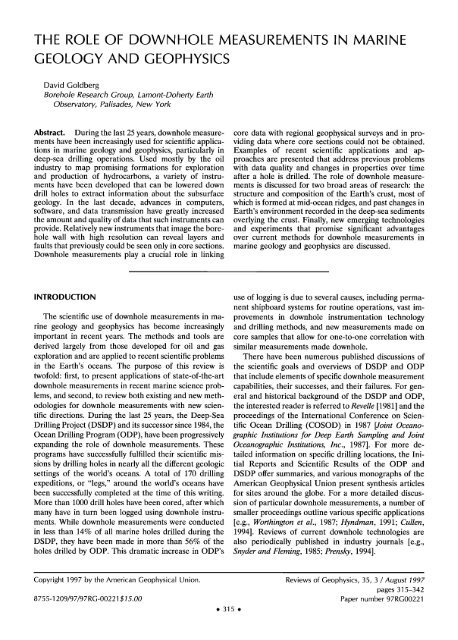
Figure 5. Schematic diagram <strong>of</strong> logg<strong>in</strong>g-while-drill<strong>in</strong>g (LWD)<br />
tools located immediately above the drill bit that enable measurements<br />
with<strong>in</strong> m<strong>in</strong>utes after the hole is made [from Shipley<br />
et al., 1995].<br />
tion, among other properties discussed below, to be<br />
made m<strong>in</strong>utes after the drill bit cuts through the formanor<br />
sonic measurements made while drill<strong>in</strong>g has been<br />
used yet <strong>in</strong> deep mar<strong>in</strong>e environments.<br />
tion [e.g., Allen et al., 1989; Bonner et al., 1992; Murphy,<br />
<strong>Downhole</strong> <strong>Measurements</strong>: Long-Term Observatories<br />
1993]. A schematic diagram <strong>of</strong> LWD <strong>in</strong>struments is<br />
<strong>and</strong> Multiple Reentry Logg<strong>in</strong>g<br />
shown <strong>in</strong> Figure 5. <strong>The</strong>se sensors allow data to be<br />
In recent years, several <strong>in</strong>dependent approaches to<br />
recorded almost immediately after drill<strong>in</strong>g, so that<br />
long-term <strong>and</strong> multiple-reentry measurements <strong>in</strong> boreephemeral<br />
<strong>in</strong> situ physical properties can be measured.<br />
holes have been based on the emplacement <strong>of</strong> <strong>in</strong>stru-<br />
<strong>The</strong> primary advantage <strong>of</strong> LWD over wirel<strong>in</strong>e logg<strong>in</strong>g <strong>in</strong> ments after drill<strong>in</strong>g is completed. Such experiments are<br />
near-vertical oceanic holes is that data can be acquired designed to measure seismic, physical, <strong>and</strong> fluid properwithout<br />
gaps below the seafloor, at the bottom <strong>of</strong> the ties, pore pressure, <strong>and</strong> chemistry <strong>in</strong> reoccupied mar<strong>in</strong>e<br />
drill hole, or through <strong>in</strong>tervals that are difficult to drill boreholes that have recovered from drill<strong>in</strong>g-<strong>in</strong>duced dis<strong>and</strong><br />
<strong>of</strong>ten deteriorate after drill<strong>in</strong>g. However, differences turbance over periods <strong>of</strong> months to years. Long-term<br />
<strong>in</strong> measurement technologies must be taken <strong>in</strong>to consid- borehole observations may be used to monitor many<br />
eration when directly compar<strong>in</strong>g results from wirel<strong>in</strong>e geologic processes, <strong>in</strong>clud<strong>in</strong>g tectonic movements, heat<br />
<strong>and</strong> LWD tools [e.g., Evans, 1991].<br />
flow, hydrogeology, <strong>and</strong> earthquake activity.<br />
Instruments for mak<strong>in</strong>g measurements while drill<strong>in</strong>g One technology that has recently been developed<br />
have recently been developed for <strong>in</strong>vestigat<strong>in</strong>g a variety allows for seafloor reentry <strong>of</strong> preexist<strong>in</strong>g holes <strong>and</strong> their<br />
<strong>of</strong> other formation properties. When acoustic velocities hydraulic seal<strong>in</strong>g <strong>and</strong> <strong>in</strong>strumentation for long-term<br />
exceed approximately 2 km/s, they can be measured monitor<strong>in</strong>g <strong>of</strong> <strong>in</strong> situ temperature <strong>and</strong> pressure. To do<br />
dur<strong>in</strong>g drill<strong>in</strong>g [e.g.,Aron et al., 1994]. A resistivity device this, the exchange <strong>of</strong> seawater with formation fluids must<br />
can be used to generate high-resolution (approximately be sealed <strong>of</strong>f, the seafloor itself <strong>in</strong> the vic<strong>in</strong>ity <strong>of</strong> the<br />
5 cm), oriented images us<strong>in</strong>g sensor electrodes that borehole must be impermeable relative to deeper layers,<br />
rotate near the drill<strong>in</strong>g bit <strong>and</strong> produce a full 360 ø scan <strong>and</strong> time must elapse to allow the borehole pressure <strong>and</strong><br />
<strong>in</strong> medium- to high-resistivity formations, as shown <strong>in</strong> temperature to return to their ambient conditions before<br />
Figure 6 [Lovell et al., 1995]. <strong>The</strong> recorded images re- drill<strong>in</strong>g. Regions <strong>of</strong> permeable ocean crust overla<strong>in</strong> by<br />
semble FMI data with somewhat poorer resolution, but mar<strong>in</strong>e sediments, buried faults, <strong>and</strong> deep deformation<br />
unlike the FMI, wall coverage is complete <strong>and</strong> data are zones are good environments for such experiments.<br />
recorded before hole conditions can severely deterio- Fluid samplers <strong>and</strong> thermistor arrays can be emplaced <strong>in</strong><br />
rate. Us<strong>in</strong>g these image data, three-dimensional strati- sealed boreholes to monitor pressure, temperature, <strong>and</strong><br />
graphic <strong>and</strong> structural <strong>in</strong>terpretation is possible with less fluid changes under <strong>in</strong> situ conditions for up to 3 years<br />
than complete core recovery. Neither resistivity imag<strong>in</strong>g after deployment us<strong>in</strong>g current data-record<strong>in</strong>g capabili-<br />
E
322 ß Goldberg: DOWNHOLE MEASUREMENTS 35, 3 /REVIEWS OF GEOPHYSICS<br />
RAB Image<br />
TOP BOTTOM TOP TOP<br />
ß<br />
..i'it;::i:;:.;;:<br />
FMI Image<br />
BOTTOM<br />
..<br />
, .,, .<br />
..<br />
.<br />
ß<br />
..<br />
ß<br />
'.L ., i:, .... " ....<br />
TOP<br />
Figure 6. Comparison <strong>of</strong> (left) Resistivity-at-bit<br />
LWD tool <strong>and</strong> (right) FMI wirel<strong>in</strong>e tool electrical<br />
images <strong>of</strong> dense fractur<strong>in</strong>g <strong>in</strong> mar<strong>in</strong>e<br />
sediments [after Lovell et al., 1995]. Both images<br />
<strong>of</strong> the <strong>in</strong>terior <strong>of</strong> the borehole wall are<br />
oriented to top at 0 ø magnetic decl<strong>in</strong>ation. Although<br />
the LWD tool measures with >30 times<br />
poorer vertical resolution than the wirel<strong>in</strong>e<br />
tool, it <strong>of</strong>fers the advantage <strong>of</strong> data coverage<br />
around the entire circumference <strong>of</strong> the bore-<br />
hole <strong>and</strong> measurements with<strong>in</strong> m<strong>in</strong>utes after<br />
the hole is made. See Table 1 for list <strong>of</strong> abbre-<br />
viations.<br />
ties [Davis et al., 1992]. S<strong>in</strong>ce 1991, more than 10 <strong>in</strong>stru- frequency seismic noise as a step toward evaluat<strong>in</strong>g<br />
mented <strong>and</strong> sealed borehole observatories have been different approaches to acquir<strong>in</strong>g broadb<strong>and</strong> seismic<br />
established by ODP. <strong>The</strong> borehole seal <strong>and</strong> <strong>in</strong>strumen- data <strong>in</strong> the world's oceans. Stephen et al. [1994] <strong>in</strong>dicated<br />
tation package must be deployed us<strong>in</strong>g a drill ship; that seismic noise <strong>in</strong> the upper 100 m <strong>of</strong> sediments below<br />
subsequently, an observatory may be serviced <strong>and</strong> data the seafloor was reduced for a borehole geophone sysrecovered<br />
by submersible or by remote-operation vehi- tem deployed dur<strong>in</strong>g a wirel<strong>in</strong>e reentry operation <strong>in</strong> the<br />
cles. Davis <strong>and</strong> Becker [1994] describe the prelim<strong>in</strong>ary western Atlantic.<br />
results <strong>of</strong> recovered temperature data from the earliest Most logg<strong>in</strong>g tools could be deployed by wirel<strong>in</strong>e<br />
borehole observatories, which <strong>in</strong>dicate that high-temper- reentry. <strong>Downhole</strong> tools that were omitted dur<strong>in</strong>g drilature<br />
fluids may be expelled for long periods <strong>of</strong> time <strong>in</strong> l<strong>in</strong>g operations because <strong>of</strong> time or weather restrictions<br />
the crust. Long-term fluid samplers emplaced <strong>in</strong> bore- or tools that are too large to be lowered through the drill<br />
hole observatories have not yet been recovered. pipe could be used. Current ODP limitations restrict<br />
<strong>Downhole</strong> logs have been recorded by revisit<strong>in</strong>g <strong>and</strong> <strong>in</strong>struments to those that can be lowered through a<br />
reenter<strong>in</strong>g preexist<strong>in</strong>g holes after drill<strong>in</strong>g us<strong>in</strong>g st<strong>and</strong>ard 10-cm drill pipe, yet they must be able to make measureoceanographic<br />
ships <strong>and</strong> submersible-assisted systems ments <strong>in</strong> holes that are <strong>of</strong>ten as large as 30 cm <strong>in</strong><br />
[Langseth <strong>and</strong> Spiess, 1987; Gable <strong>and</strong> DIANA UT Ship- diameter. This gap seriously limits sensor design <strong>and</strong><br />
board Party, 1992; Spiess et al., 1992]. In these reentry restricts the use <strong>of</strong> many exist<strong>in</strong>g wirel<strong>in</strong>e devices. Boreexperiments<br />
a remote deep-sea vehicle suspended vari- hole gravimeters that measure bulk density, resistivity<br />
ous logg<strong>in</strong>g tools over preexist<strong>in</strong>g holes <strong>and</strong> lowered imag<strong>in</strong>g tools that extend for greater borehole coverage,<br />
them on a wirel<strong>in</strong>e. <strong>The</strong> DIANAUT program [Gable <strong>and</strong> nuclear magnetic resonance tools that estimate sediment<br />
DIANA UT Shipboard Party, 1992] used a submersible- permeability, <strong>and</strong> downhole samplers that extract pore<br />
assisted system to reenter three Atlantic holes. Wire l<strong>in</strong>e fluids could be deployed by wirel<strong>in</strong>e reentry [e.g.,<br />
operations at these sites <strong>in</strong>cluded temperature, caliper, Schultz, 1989; Colley et al., 1992; Black, 1992; Schlum<strong>and</strong><br />
borehole televiewer logs; clamped borehole seis- berger Educational Services, 1992; Motriss et al., 1993]. In<br />
mometers; <strong>and</strong> downhole fluid samplers [Floury <strong>and</strong> addition, holes drilled through unstable formations that<br />
Gable, 1992; Mor<strong>in</strong> et al., 1992; Gieskes <strong>and</strong> Magenheim, must be cased to prevent collapse can be logged with<br />
1992]. <strong>The</strong> postdrill<strong>in</strong>g thermal equilibration <strong>of</strong> these certa<strong>in</strong> tools by wirel<strong>in</strong>e reentry. Porosity <strong>and</strong> velocity<br />
holes was critical for accurate <strong>in</strong> situ temperature <strong>and</strong> have been measured successfully beh<strong>in</strong>d the cas<strong>in</strong>g us<strong>in</strong>g<br />
fluid sampl<strong>in</strong>g; <strong>in</strong> addition, the negligible effects <strong>of</strong> heave high-energy nuclear <strong>and</strong> low-frequency shear sonic tools<br />
for submersible-assisted reentry operations improved that penetrate deeply <strong>in</strong>to the borehole wall [e.g., Moos<br />
depth accuracy <strong>of</strong> the imag<strong>in</strong>g <strong>and</strong> high-resolution logs. et al., 1997]. When repeated logs are acquired by wire-<br />
Spiess et al. [1992] <strong>and</strong> Montagner et al. [1994] described l<strong>in</strong>e reentry, whether to compensate for time, technical,<br />
wirel<strong>in</strong>e reentry experiments for mar<strong>in</strong>e tests <strong>of</strong> low- or physical constra<strong>in</strong>ts dur<strong>in</strong>g drill<strong>in</strong>g operations, the
35, 3 /REVIEWS OF GEOPHYSICS Goldberg' DOWNHOLE MEASUREMENTS ß 323<br />
data can also be used to study temporal changes <strong>in</strong><br />
formation properties over periods <strong>of</strong> days to years.<br />
Over time, the physical properties <strong>of</strong> formations penetrated<br />
by a borehole, as well as the borehole itself,<br />
change as stresses are applied <strong>and</strong> fluids flow through<br />
them. Such temporal changes can be measured only over<br />
an elapsed period <strong>of</strong> time. <strong>Downhole</strong> measurements<br />
made days to years after a borehole is drilled allow<br />
properties such as temperature <strong>and</strong> pore fluid composition<br />
to approach their condition prior to drill<strong>in</strong>g. Repeated<br />
deployment <strong>of</strong> wirel<strong>in</strong>e logg<strong>in</strong>g tools provides<br />
logs that reflect temporal changes <strong>in</strong> the physical <strong>and</strong><br />
borehole properties. An example <strong>of</strong> temperature logs<br />
repeated dur<strong>in</strong>g four experimental episodes spann<strong>in</strong>g<br />
6.5 years is shown <strong>in</strong> Figure 7. <strong>The</strong>se temperature logs<br />
were recorded <strong>in</strong> ODP Hole 504B <strong>in</strong> the eastern equatorial<br />
Pacific as drill<strong>in</strong>g penetrated progressively deeper<br />
<strong>in</strong>to the oceanic crust <strong>and</strong> illustrate the change <strong>in</strong> the<br />
movement <strong>of</strong> fluids <strong>in</strong> the ocean crust over time [Langseth<br />
et al., 1983; Gable et al., 1989]. Alt et al. [1993]<br />
estimate the equilibrium bottom hole temperature to be<br />
about 195øC at a depth <strong>of</strong> 2111 m below the seafloor.<br />
Becker et al. [1983], among others, describe a decrease,<br />
followed by an <strong>in</strong>crease, <strong>in</strong> fluid flow with<strong>in</strong> the upper<br />
400 m <strong>of</strong> the borehole s<strong>in</strong>ce it was drilled, as monitored<br />
by these successive temperature logs. <strong>The</strong> decrease <strong>in</strong><br />
temperatures reflects the downhole flow <strong>of</strong> cold seawater<br />
through permeable cracks <strong>and</strong> faults <strong>in</strong> the oceanic<br />
crust, which results <strong>in</strong> chemical exchanges with the rock<br />
[Alt et al., 1986]. <strong>Downhole</strong> temperature measurements<br />
made over time, as well as long-term measurements<br />
made <strong>in</strong> sealed boreholes, allow for study <strong>of</strong> the longevity<br />
<strong>and</strong> distribution <strong>of</strong> fluid circulation <strong>in</strong> the crust.<br />
Experimental Strategy<br />
<strong>The</strong> best designed downhole experiments take <strong>in</strong>to<br />
account which <strong>in</strong>strument, or comb<strong>in</strong>ation <strong>of</strong> <strong>in</strong>struments,<br />
will provide the highest-quality data needed to<br />
address a scientific objective. Drill<strong>in</strong>g technology also<br />
dramatically affects the collection <strong>of</strong> high-quality downhole<br />
<strong>in</strong>formation. An appropriate strategy may <strong>in</strong>clude<br />
the drill<strong>in</strong>g <strong>of</strong> dedicated holes for wirel<strong>in</strong>e logg<strong>in</strong>g, use <strong>of</strong><br />
logg<strong>in</strong>g while drill<strong>in</strong>g, wirel<strong>in</strong>e reentry logg<strong>in</strong>g, repeat<strong>in</strong>g<br />
logs over time, or <strong>in</strong>terpretation <strong>of</strong> logs jo<strong>in</strong>tly with core<br />
analyses. Improved experimental strategies have contributed<br />
as much to the success <strong>of</strong> downhole measure-<br />
lOOO<br />
lfiOO<br />
Leg 148 (1993)<br />
......... Leg 111 (1986)<br />
Leg 140 (1991),<br />
..... Leg 137 (1991)<br />
2000<br />
0 50 100 150 200<br />
Temperature ("C)<br />
Figure 7. Temperature logs recorded <strong>in</strong> ODP Hole 504B<br />
successively dur<strong>in</strong>g four expeditions over 6.5 years [after Alt et<br />
al., 1993]. <strong>The</strong> variations <strong>in</strong> temperature over time illustrate<br />
the episodic downhole flow <strong>of</strong> cool ocean water <strong>in</strong>to the<br />
uppermost 300-400 m <strong>of</strong> porous formations below the seafloor.<br />
exam<strong>in</strong>ation. Without a riser, fluid circulates down the<br />
drill pipe but is not returned to the surface, <strong>and</strong> the hole<br />
conditions are less stable. In addition, the diameter <strong>of</strong><br />
the drill pipe is larger when a riser is used, allow<strong>in</strong>g more<br />
ments <strong>in</strong> mar<strong>in</strong>e geology <strong>and</strong> geophysics as the development<br />
<strong>of</strong> new <strong>in</strong>strument technology.<br />
<strong>The</strong> lack <strong>of</strong> a riser <strong>and</strong> drill<strong>in</strong>g mud cake <strong>in</strong> deep<br />
mar<strong>in</strong>e drill<strong>in</strong>g operations makes the use <strong>of</strong> wirel<strong>in</strong>e<br />
width for downhole <strong>in</strong>struments. Nevertheless, eng<strong>in</strong>eer<strong>in</strong>g<br />
advances have improved hole conditions for downhole<br />
measurements <strong>in</strong> lieu <strong>of</strong> a riser. Among the most<br />
prom<strong>in</strong>ent, a drill pipe is lowered to clear borehole<br />
logg<strong>in</strong>g technology more challeng<strong>in</strong>g than <strong>in</strong> cont<strong>in</strong>ental<br />
obstructions while a wirel<strong>in</strong>e tool is downhole. <strong>The</strong> drilor<br />
oil <strong>in</strong>dustry drill<strong>in</strong>g, where risers are commonplace. A l<strong>in</strong>g <strong>of</strong> dedicated holes without cor<strong>in</strong>g also improves hole<br />
riser system circulates drill<strong>in</strong>g fluid down the drill pipe, conditions for downhole measurements. In the future,<br />
through the bit, <strong>and</strong> around the exterior <strong>of</strong> the drill pipe with the development <strong>of</strong> the planned deep-sea riser<br />
back to the platform. <strong>The</strong> drill<strong>in</strong>g fluid, or "mud," usu- system <strong>and</strong> other eng<strong>in</strong>eer<strong>in</strong>g advances, drill<strong>in</strong>g <strong>and</strong> hole<br />
ally conta<strong>in</strong>s dense <strong>and</strong> viscous compounds that clean conditions are expected to improve well beyond current<br />
the borehole, build up a mud cake to stabilize it for capabilities <strong>and</strong> to cont<strong>in</strong>ue to add to the scientific<br />
logg<strong>in</strong>g, <strong>and</strong> return rock cutt<strong>in</strong>gs to the surface for success <strong>of</strong> these experiments.
324 ß Goldberg: DOWNHOLE MEASUREMENTS 35, 3 / REVIEWS OF GEOPHYSICS<br />
SCIENTIFIC APPLICATIONS<br />
[e.g., Hays et al., 1976; Shackelton et al., 1984]. Due to the<br />
gravitational pull <strong>of</strong> the Sun <strong>and</strong> Moon on the equatorial<br />
<strong>The</strong>re are few areas <strong>of</strong> mar<strong>in</strong>e geology <strong>and</strong> geophysics bulge <strong>of</strong> the Earth, our planet wobbles slightly as it sp<strong>in</strong>s,<br />
that cannot benefit from logg<strong>in</strong>g <strong>and</strong> downhole measure- def<strong>in</strong><strong>in</strong>g its precession. This wobble results <strong>in</strong> climate<br />
ments. Data are recorded <strong>in</strong> situ <strong>and</strong> usually <strong>in</strong> a con- cycles that last 19,000-23,000 years. <strong>The</strong> Earth's tilt, or<br />
t<strong>in</strong>uous pr<strong>of</strong>ile to the bottom <strong>of</strong> the borehole, provid<strong>in</strong>g obliquity, varies with a period <strong>of</strong> 41,000 years, <strong>and</strong> its<br />
researchers with an accurate proxy <strong>of</strong> the geology at orbit varies from nearly circular to 95 % eccentricity with<br />
various depths. Exploration <strong>of</strong> the structure, deforma- periods <strong>of</strong> 95,000 <strong>and</strong> 413,000 years, affect<strong>in</strong>g its distance<br />
tion, <strong>and</strong> stresses <strong>in</strong> the Earth's crust that are accessible from the Sun. <strong>The</strong>se periodicities have been observed <strong>in</strong><br />
by drill<strong>in</strong>g has <strong>of</strong>ten been supplemented by downhole a number <strong>of</strong> mar<strong>in</strong>e <strong>and</strong> terrestrial sedimentary environmeasurements<br />
<strong>and</strong> proven to be critical <strong>in</strong> underst<strong>and</strong>- ments. Pliocene <strong>and</strong> Pleistocene mar<strong>in</strong>e sediments have<br />
<strong>in</strong>g subsurface phenomena. <strong>The</strong> Earth's environment demonstrated the clearest correlation between sedimenlikewise<br />
has been <strong>in</strong>vestigated by scientific drill<strong>in</strong>g <strong>and</strong> tary layers <strong>and</strong> Milankovitch periodicities because <strong>of</strong> the<br />
downhole measurements to discern details <strong>of</strong> the sedi- high recovery <strong>of</strong> material that can be accurately dated<br />
ment record over time. In the follow<strong>in</strong>g sections, recent us<strong>in</strong>g mar<strong>in</strong>e core sections. Climate cycles are not limresearch<br />
studies that highlight the application <strong>of</strong> down- ited to the younger sediments, however; cor<strong>in</strong>g <strong>in</strong> both<br />
hole measurements to topics related to the Earth's en- Cretaceous <strong>and</strong> Triassic rocks shows evidence <strong>of</strong> Mivironment<br />
<strong>and</strong> Earth's crust are discussed.<br />
lankovitch cycles [Arthur et aL, 1984; Fischer, 1986; Olsen,<br />
1986].<br />
Paleoclimate<br />
Milankovitch orbital variations may alter the deposi-<br />
Because Earth's climate has large effects on the tional environment considerably. Spectral analysis <strong>of</strong> the<br />
ocean's chemistry, circulation, <strong>and</strong> biological productiv- cont<strong>in</strong>uous <strong>and</strong> regular sampl<strong>in</strong>g that log data provide<br />
ity, changes <strong>in</strong> the global environment leave a recogniz- can resolve Milankovitch periodicities <strong>and</strong> thus sedimenable<br />
signature <strong>in</strong> the deep-sea sedimentary record. How tation rates for a known depth <strong>in</strong>terval. In cores, sedithe<br />
global climate system has changed <strong>and</strong> the causes <strong>of</strong> mentation rates are typically determ<strong>in</strong>ed by estimat<strong>in</strong>g<br />
these changes therefore may be deduced from downhole the elapsed time between biostratigraphic, radioisotopic,<br />
data if these signatures can be measured. Short- <strong>and</strong> or magnetostratigraphic markers that can be identified.<br />
long-term changes <strong>in</strong> such variables as temperature, This requires an absolute timescale, which can be suphumidity,<br />
<strong>and</strong> w<strong>in</strong>d patterns, the <strong>in</strong>flux <strong>of</strong> energy from plied by correlat<strong>in</strong>g Milankovitch periodicities with the<br />
the Sun, sea level, water temperature, <strong>and</strong> oceanic up- cores. Us<strong>in</strong>g the cont<strong>in</strong>uous logs to identify cycles, a<br />
well<strong>in</strong>g can all affect the m<strong>in</strong>eralogy, porosity, <strong>and</strong> gra<strong>in</strong> timescale can be extended millions <strong>of</strong> years <strong>in</strong>to the past<br />
size <strong>of</strong> sediment layers deposited on the seafloor. Most with greater precision than can be achieved with the<br />
downhole log responses are affected by sediment poros- core-based methods alone. Log data may be used to<br />
ity, which is closely related to the m<strong>in</strong>eralogy <strong>and</strong> gra<strong>in</strong> illustrate major trends <strong>and</strong> rapid changes <strong>in</strong> the sedisize,<br />
both <strong>of</strong> which can vary dramatically as ocean up- mentation rate by shifts <strong>in</strong> the wavelength <strong>of</strong> their variwell<strong>in</strong>g<br />
patterns <strong>and</strong> mean water temperature alter bio- ation with depth <strong>in</strong> areas with variable or discont<strong>in</strong>uous<br />
logic productivity. <strong>The</strong> amount <strong>of</strong> clay <strong>in</strong>corporated <strong>in</strong> accumulation or poor age control from core data [Mothe<br />
sediment is also <strong>of</strong>ten determ<strong>in</strong>ed by climate <strong>and</strong> will l<strong>in</strong>ie et al., 1990]. Jarrard <strong>and</strong> Arthur [1989] describe a<br />
strongly affect the m<strong>in</strong>eralogy <strong>and</strong> porosity. <strong>The</strong> natural method to determ<strong>in</strong>e sedimentation rates us<strong>in</strong>g log data<br />
gamma ray log is particularly sensitive to these variations that requires neither precise biostratigraphy nor an ab<strong>in</strong><br />
clay content. If the temporal changes can be ade- solute timescale. <strong>The</strong>y constra<strong>in</strong> the sedimentation rate<br />
quately resolved, the geophysical <strong>and</strong> geochemical mea- to the Milankovitch orbital periods by comput<strong>in</strong>g spectra<br />
surements taken downhole can serve as proxies for cli- <strong>of</strong> log data <strong>and</strong> identify<strong>in</strong>g peaks <strong>in</strong> the cont<strong>in</strong>uous<br />
mate change <strong>in</strong> the sediment record. Us<strong>in</strong>g downhole spectra that have a constant spac<strong>in</strong>g ratio between them.<br />
logs <strong>in</strong> paleoclimate studies has the significant advantage <strong>The</strong> use <strong>of</strong> spectra for <strong>in</strong>terpret<strong>in</strong>g precise sedimenta<strong>of</strong><br />
measur<strong>in</strong>g several <strong>in</strong>dependent parameters that all tion rates between time markers identified <strong>in</strong> cores has<br />
reflect climatic changes throughout the stratigraphic se- proven to be a powerful technique <strong>in</strong> paleoclimate studies.<br />
quence. In addition, the cont<strong>in</strong>uous <strong>and</strong> uniform sam- In 1989, a site <strong>in</strong> the Sea <strong>of</strong> Japan was drilled through<br />
pl<strong>in</strong>g <strong>of</strong> downhole records allows for rigorous statistical 2.8 m.y. <strong>of</strong> f<strong>in</strong>e sediment layers to a depth <strong>of</strong> 459 m<br />
analyses that are not possible us<strong>in</strong>g short or <strong>in</strong>complete below the seafloor. Ingle et al. [1990] describe the recovdata<br />
from core sections.<br />
ered core as dark opal-rich layers with organic carbon<br />
Of the numerous <strong>in</strong>terrelated factors driv<strong>in</strong>g climatic <strong>in</strong>terlayered with clay-rich sediments that are derived<br />
changes, few are generally accepted to be more impor- from aeolian dust blown from loess deposits <strong>in</strong> Ch<strong>in</strong>a.<br />
tant than the variation <strong>in</strong> Earth's tilt <strong>and</strong> orbital cycles <strong>The</strong> layers alternate about every 4 m. Variation <strong>in</strong> nataround<br />
the Sun. Milankovitch [1941] was the first to ural gamma radioactivity versus age <strong>in</strong> this hole is shown<br />
recognize that periodicity <strong>in</strong> Earth's orbit <strong>and</strong> tilt alters <strong>in</strong> Figure 8, where the age-depth conversion has been<br />
the solar energy flux fall<strong>in</strong>g at any given latitude <strong>in</strong> cycles computed from a sedimentation rate that was conlast<strong>in</strong>g<br />
thous<strong>and</strong>s to hundreds <strong>of</strong> thous<strong>and</strong>s <strong>of</strong> years stra<strong>in</strong>ed by paleomagnetic reversals <strong>and</strong> biostratigraphy
35, 3 /REVIEWS OF GEOPHYSICS Goldberg: DOWNHOLE MEASUREMENTS ß 325<br />
recorded from the core. Increases <strong>in</strong> gamma radiation<br />
reflect high clay content <strong>of</strong> the cont<strong>in</strong>ental clay-rich<br />
layers, which have abundant K <strong>and</strong> A1. <strong>The</strong>se cyclical<br />
signatures are apparent <strong>in</strong> other downhole data; the<br />
density <strong>and</strong> resistivity logs reflect the lower porosity <strong>of</strong><br />
the cont<strong>in</strong>ental clays. DeMenocat et at. [1992] compare<br />
the gamma ray log <strong>and</strong> a mar<strong>in</strong>e 8SO record to illustrate<br />
the strong correlation with variations <strong>in</strong> northern hemisphere<br />
ice volume [e.g., Raytoo et at., 1989]. <strong>The</strong> concentration<br />
<strong>of</strong> 8SO has <strong>of</strong>ten been used as a proxy for<br />
paleoclimatic changes <strong>in</strong> ice volume, temperature, <strong>and</strong><br />
sea level because it has a lower concentration <strong>in</strong> fresh<br />
water from polar ice than <strong>in</strong> seawater. When polar<br />
temperatures decrease, ice volume <strong>in</strong>creases <strong>and</strong> sea<br />
level drops; <strong>in</strong> warmer periods, ice volume decreases <strong>and</strong><br />
sea level rises. <strong>The</strong> <strong>in</strong>creased gamma radioactivity <strong>in</strong> the<br />
clays <strong>in</strong> the Sea <strong>of</strong> Japan is associated with long periods<br />
Age<br />
(Ma)<br />
<strong>of</strong> drought when loess deposits erode <strong>and</strong> are transported<br />
eastward by prevail<strong>in</strong>g w<strong>in</strong>ds. When the Asian<br />
climate warms, the major deposition <strong>in</strong> the Sea <strong>of</strong> Japan<br />
is much lower <strong>in</strong> radioactive K as well as A1, <strong>and</strong> the<br />
deposits are <strong>in</strong>terpreted to be fluvial.<br />
<strong>The</strong> most prom<strong>in</strong>ent periodicity <strong>of</strong> the climatic variation<br />
<strong>in</strong> the Sea <strong>of</strong> Japan is 41,000 years, correspond<strong>in</strong>g<br />
2.0<br />
with the predicted Milankovitch cycle caused by changes<br />
<strong>in</strong> Earth's tilt. Figure 9 illustrates how the downhole logs<br />
from the Sea <strong>of</strong> Japan can be used to determ<strong>in</strong>e characteristic<br />
periodicities for a time <strong>in</strong>terval. Note that<br />
2.5<br />
different <strong>in</strong>struments vary <strong>in</strong> their time resolution. All<br />
i,-1,,, i,,, i,, ,i<br />
three resistivity logs show the characteristic 41,000-year<br />
100 60 20<br />
periodicity, as well as variability at shorter periods, us<strong>in</strong>g<br />
two <strong>of</strong> the three different tools, the shallow resistivity log<br />
798B Gamma Ray<br />
with 0.75-m resolution <strong>and</strong> the FMS log with 5-mm<br />
Incr. terrigenous content<br />
resolution (see Figure 4). Worth<strong>in</strong>gton [1990] described a<br />
relationship based on the Nyquist periodic sampl<strong>in</strong>g<br />
Figure 8. Correlation <strong>of</strong> the natural gamma radiation log <strong>in</strong><br />
ODP Hole 798A <strong>in</strong> the Sea <strong>of</strong> Japan with the mar<strong>in</strong>e sO<br />
condition between the <strong>in</strong>strument resolution h (<strong>in</strong><br />
record from the North Atlantic [from deMenocal et al., 1992].<br />
meters), the sedimentation rate s (<strong>in</strong> meters per million<br />
<strong>The</strong> depth scale <strong>of</strong> the log was converted to age us<strong>in</strong>g the<br />
years), <strong>and</strong> the cycle period -r (<strong>in</strong> millions <strong>of</strong> years) to be paleomagnetic reversal sequence shown. <strong>The</strong> f<strong>in</strong>e-scale correh<br />
= s-r/2. For a given sedimentation rate, climate cycles lation between the logs confirms that aridity dur<strong>in</strong>g glacial<br />
below this resolution limit <strong>of</strong> the <strong>in</strong>strument will be<br />
periods cause terrigeneous deposits <strong>in</strong> the Sea <strong>of</strong> Japan.<br />
aliased <strong>and</strong> appear at lower frequencies. <strong>The</strong> deep resistivity<br />
log has 2-m vertical resolution <strong>and</strong> requires a<br />
sedimentation rate <strong>of</strong> at least 20 m/m.y. to detect eccen- periods <strong>in</strong> the range <strong>of</strong> 2000-10,000 years are not well<br />
tricity cycles <strong>of</strong> 95,000-123,000 or 413,000 years <strong>and</strong> at understood, but they have been l<strong>in</strong>ked to cycles <strong>in</strong> ocean<br />
least 100 m/m.y. to detect precession cycles <strong>of</strong> 19,000- circulation, iceberg raft<strong>in</strong>g <strong>in</strong> surface waters, <strong>and</strong> solar<br />
23,000 years. With the FMS tool the m<strong>in</strong>imum sedimen- radiation [e.g., Dansgaard et al., 1982; Henrich, 1989].<br />
tation rate required for detection <strong>of</strong> 19,000- to 23,000- <strong>The</strong> ability to predict these short-period, non-Milankoyear<br />
precession cycles is 22 m/m.y., which is commonly vitch events that cause abrupt changes <strong>in</strong> climate may<br />
exceeded <strong>in</strong> many nonerosive mar<strong>in</strong>e environments. Us- benefit society significantly if potential hazards due to sea<br />
<strong>in</strong>g the FMS, cycles at even f<strong>in</strong>er scales can be detected. level rise, drought, or solar radiation can be prevented.<br />
For example, the 7-m <strong>in</strong>terval <strong>of</strong> the FMS log <strong>in</strong> Figure In summary, the wide variety <strong>of</strong> properties measured<br />
9 corresponds approximately with a 60,000-year <strong>in</strong>terval us<strong>in</strong>g logs can detect periodic changes due to climate or<br />
shown <strong>in</strong> the deep <strong>and</strong> shallow resistivity logs <strong>and</strong> re- other driv<strong>in</strong>g forces cont<strong>in</strong>uously <strong>and</strong> at extremely f<strong>in</strong>e<br />
solves cycles with suborbital periods as short as 6000 scale. Detection methods us<strong>in</strong>g downhole data are powyears.<br />
Peaks <strong>in</strong> the spectrum represent the 41,000-year erful, rapid, <strong>and</strong> complete compared with laboratory<br />
cycles as well as the lower-magnitude peaks at suborbital analyses on core samples <strong>and</strong> are <strong>in</strong>dependent <strong>of</strong> core<br />
periods <strong>of</strong> 6000, 8000, <strong>and</strong> 12,000 years [deMenocat <strong>and</strong> recovery, which is rarely cont<strong>in</strong>uous <strong>in</strong> the deeper bore-<br />
K<strong>in</strong>g, 1995]. <strong>The</strong> causes <strong>and</strong> consequences <strong>of</strong> suborbital holes.<br />
1.0<br />
1.5<br />
18<br />
Glacial Interglacial<br />
Jar<br />
5 4.5 4 3.5 3<br />
I''''1 .... I''''1''''1<br />
Old --<br />
ß
326 ß Goldberg: DOWNHOLE MEASUREMENTS 35, 3 / REVIEWS OF GEOPHYSICS<br />
1.15<br />
1.20<br />
1.25<br />
Age<br />
(Ma)<br />
1.30<br />
1.35<br />
1.45<br />
ß<br />
0.4<br />
Resistivity<br />
0.8<br />
FMS (16 button avg.)<br />
4 2 0 -2 -4 -6<br />
125 ,,,,,,,,,<br />
126<br />
127<br />
128<br />
129 %<br />
.....<br />
130<br />
10-<br />
10 -2<br />
10 -3<br />
10 -4<br />
10 -6<br />
Site 798B<br />
Sub-orbital variability<br />
41 kyr<br />
12-13 kyr<br />
8 kyr<br />
6 kyr<br />
0 0.05 0.1 0.15 0.2 0.25 0.3<br />
1.4o 41 kyr cycles freq (i/kyr)<br />
132 I<br />
Figure 9. Comparison <strong>of</strong> data from three wirel<strong>in</strong>e resistivity tools: shallow <strong>and</strong> deep resistivity <strong>and</strong> the<br />
averaged FMS record that show cycles at a 41,000-year orbital period <strong>and</strong> below <strong>in</strong> the comparative power<br />
spectra [after deMenocal <strong>and</strong> K<strong>in</strong>g, 1995]. <strong>The</strong> resistivity logs have been converted to age, <strong>and</strong> the averaged<br />
FMS data are plotted on relative scale over a 7-m <strong>in</strong>terval. <strong>The</strong> f<strong>in</strong>e vertical resolution <strong>of</strong> the FMS data allows<br />
observation <strong>of</strong> periods as short as 6000 years.<br />
Magnetostratigraphy<br />
<strong>and</strong> correlated both with core measurements <strong>and</strong> with<br />
<strong>The</strong> ability to obta<strong>in</strong> direct <strong>and</strong> closely spaced mea- the geomagnetic polarity timescale over several hundred<br />
surements <strong>of</strong> absolute age has been a long-term goal <strong>of</strong> meters depth [Thibal et al., 1995]. Figure 10 shows the<br />
mar<strong>in</strong>e sediment cor<strong>in</strong>g. Usually, biostratigraphic or downhole polarity sequence compared with the reversal<br />
magnetostratigraphic time markers are identified <strong>in</strong> a time scale. Although the downhole record agrees with<br />
core sample <strong>and</strong> their age is <strong>in</strong>terpreted from the tie to the polarity sequence derived from core data, it is more<br />
a magnetic reversal timescale or biostratigraphic stage. complete <strong>and</strong> allows for a confident comparison with a<br />
From the accumulation <strong>of</strong> sediment between age markers, geomagnetic timescale. In addition, the cont<strong>in</strong>uous<br />
the sedimentation rate can be determ<strong>in</strong>ed <strong>in</strong> recovered downhole geochronology provided an un<strong>in</strong>terrupted<br />
core sections where sedimentation has been un<strong>in</strong>ter- record <strong>of</strong> paleomagnetic <strong>in</strong>tensity. Thibal et al. [1995]<br />
rupted. With the development <strong>of</strong> downhole <strong>in</strong>struments compared the cont<strong>in</strong>uous change <strong>in</strong> relative magnetic<br />
that can measure high-resolution magnetic field <strong>in</strong>ten- <strong>in</strong>tensity over time at this high-latitude site with the<br />
sity, however, a direct <strong>and</strong> cont<strong>in</strong>uous <strong>in</strong> situ record <strong>of</strong> results from low-latitude core measurements made by<br />
the mar<strong>in</strong>e magnetic reversal history may be effectively Valet <strong>and</strong> Meynadier [1993] <strong>and</strong> confirmed that magnetic<br />
measured <strong>in</strong> a variety <strong>of</strong> sedimentary environments. <strong>in</strong>tensity decreases sharply at the onset <strong>of</strong> a reversal,<br />
Precession magnetometers <strong>and</strong> <strong>in</strong>duction susceptibil- followed by an <strong>in</strong>crease <strong>in</strong> field strength. Each period <strong>of</strong><br />
ity tools have been used <strong>in</strong> comb<strong>in</strong>ation to determ<strong>in</strong>e the constant polarity then decreases <strong>in</strong> <strong>in</strong>tensity. This <strong>in</strong>ter<strong>in</strong><br />
situ magnetostratigraphy <strong>in</strong> weakly magnetized sedi- pretation <strong>of</strong> the downhole data suggests that the duraments<br />
[Desvignes et al., 1992; Etchecopar et al., 1993; tion <strong>of</strong> the Earth's polarity field is <strong>in</strong>versely proportional<br />
Pozzi et al., 1993]. <strong>The</strong>se tools are used <strong>in</strong> comb<strong>in</strong>ation <strong>in</strong> to the mean rate <strong>of</strong> decrease <strong>of</strong> magnetic <strong>in</strong>tensity, that is,<br />
order to subtract the <strong>in</strong>duced magnetization <strong>of</strong> the sed- its length is determ<strong>in</strong>ed by the <strong>in</strong>tensity <strong>of</strong> the reversal.<br />
iments from the total measured magnetic field <strong>and</strong> de- In addition, downhole magnetic susceptibility logs<br />
term<strong>in</strong>e the polarity <strong>of</strong> the remanence. In recent studies have been correlated to core susceptibility measure<strong>in</strong><br />
Pliocene sediments from the northern Pacific, rema- ments at several sites, provid<strong>in</strong>g excellent stratigraphic<br />
nent magnetostratigraphy has been measured downhole control [Pariso <strong>and</strong> Johnson, 1991; Rob<strong>in</strong>son, 1992; Du-
35, 3 / REVIEWS OF GEOPHYSICS Goldberg' DOWNHOLE MEASUREMENTS ß 327<br />
buisson et al., 1995]. In recent drill<strong>in</strong>g along the east<br />
flank <strong>of</strong> the Reykjanes Ridge <strong>in</strong> the North Atlantic,<br />
identify<strong>in</strong>g changes <strong>in</strong> the Pliocene-Pleistocene climate<br />
was improved by a high-resolution correlation <strong>of</strong> core<br />
<strong>and</strong> log measurements <strong>of</strong> magnetic susceptibility [Higg<strong>in</strong>s<br />
et al., 1997]. In Figure 11, core <strong>and</strong> log magnetic<br />
susceptibility pr<strong>of</strong>iles at a site drilled through sediments<br />
accumulated over the past 3-3.5 m.y. at a high sedimentation<br />
rate (120-170 m/m.y.) were correlated peak by<br />
peak. <strong>The</strong> log data provide stronger susceptibility signals<br />
<strong>and</strong> more cont<strong>in</strong>uous records than core measurements,<br />
fill<strong>in</strong>g gaps limited by the core recovery <strong>in</strong> the deeper<br />
<strong>in</strong>terval <strong>of</strong> the hole. Both data sets show Milankovitch<br />
periodicities extend<strong>in</strong>g to the bottom <strong>of</strong> the hole <strong>and</strong> can<br />
be used to improve biostratigraphic <strong>and</strong> magnetostratigraphic<br />
age dat<strong>in</strong>g determ<strong>in</strong>ed from cores. <strong>The</strong> dat<strong>in</strong>g <strong>of</strong><br />
sedimentary sequences us<strong>in</strong>g cont<strong>in</strong>uous magnetic logs<br />
or by correlation with Milankovitch cycles observed <strong>in</strong><br />
other logs provides a critical l<strong>in</strong>k between depth <strong>and</strong> age<br />
<strong>in</strong> mar<strong>in</strong>e bas<strong>in</strong>s.<br />
0<br />
0<br />
50-<br />
100.<br />
150i<br />
200-<br />
Z(z)<br />
(10 -6 SI)<br />
2000<br />
B'(z) Geomagnetic<br />
(nT) polarity time<br />
- 100 0 100<br />
..... I ..... ! .....<br />
scale<br />
polarity <strong>Downhole</strong><br />
: sequenc<br />
I<br />
_ -m :... :i: ....<br />
................... g :':!½i-.½..'.-: --_ ....<br />
,<br />
,<br />
,<br />
Methane Gas Hydrates<br />
<strong>Downhole</strong> measurements <strong>in</strong> sedimentary bas<strong>in</strong>s reveal<br />
<strong>in</strong> situ properties that are hard to measure from<br />
core samples, such as high-pressure <strong>and</strong> gas-rich zones.<br />
250.<br />
,<br />
Methane gas hydrates are formed from methane <strong>in</strong> the<br />
buried sediments on cont<strong>in</strong>ental marg<strong>in</strong>s when the<br />
methane-water mixture freezes at cold temperatures <strong>and</strong><br />
300. .<br />
high pressures <strong>in</strong> a thermodynamic stability zone. Often<br />
s<strong>and</strong>, clay, <strong>and</strong> mixed s<strong>and</strong>-clay sequences conta<strong>in</strong> pres-<br />
-'::: ........ . l<br />
surized, methane hydrates that can be detected by large<br />
seismic reflections that run parallel to <strong>and</strong> below the<br />
seafloor <strong>and</strong> usually <strong>in</strong>dicate their spatial distribution<br />
[e.g., Stoll, 1971; Kvenvolden, 1993; Wood et al., 1994].<br />
350.<br />
<strong>Downhole</strong> logs have recorded data <strong>of</strong> the ephemeral<br />
400<br />
properties <strong>of</strong> methane hydrates where they have been<br />
<strong>in</strong>dicated on seismic surveys but have dissolved or been<br />
severely altered by attempts to drill <strong>and</strong> core them .: ... .::...... .... . ':..<br />
[Collett, 1993; Prensky, 1995]. <strong>The</strong> downhole velocity<br />
data have proven critical <strong>in</strong> quantify<strong>in</strong>g the nature <strong>of</strong> this<br />
Figure 10. Comparison <strong>of</strong> downhole magnetic susceptibility<br />
X(z) <strong>and</strong> remanent field B' (z) results <strong>in</strong> ODP Hole 884E <strong>in</strong><br />
seismic reflection; velocity decreases ow<strong>in</strong>g to free gas<br />
the northern Pacific with the geomagnetic polarity timescale<br />
below the hydrate layer <strong>and</strong> generates a large seismic<br />
[from Thibal et al., 1995]. <strong>The</strong> <strong>in</strong>terpretation <strong>of</strong> the downhole<br />
reflection [MacKay et al., 1994; ODP Leg 164 Shipboard polarity sequence from the logs enables sedimentation rate<br />
Scientific Party, 1996]. Because the occurrence <strong>of</strong> meth- <strong>and</strong> magnetic reversal strength to be determ<strong>in</strong>ed where core<br />
ane hydrates <strong>and</strong> free gas may be predicted from seismic data are not available.<br />
data <strong>and</strong> detailed downhole velocity data, more reliable<br />
estimates <strong>of</strong> the volume <strong>of</strong> gas <strong>and</strong> methane hydrate can<br />
be made to <strong>in</strong>dicate the extent <strong>of</strong> this vast untapped ties are essential. On the Guatemala marg<strong>in</strong>, evidence <strong>of</strong><br />
natural resource.<br />
high pressure was found <strong>in</strong> both recovered core <strong>and</strong> <strong>in</strong><br />
Ocean drill<strong>in</strong>g has acquired logs <strong>in</strong> methane hydrate logs <strong>of</strong> a 10-m-thick methane hydrate about 250 m below<br />
at several sites, most recently on the Blake Ridge <strong>of</strong>f <strong>of</strong> the seafloor [Mathews <strong>and</strong> yon Huene, 1985]. <strong>The</strong> data<br />
the U.S. eastern seaboard. Other locations <strong>of</strong> mar<strong>in</strong>e <strong>in</strong>dicated low gamma ray <strong>and</strong> density, high electrical<br />
hydrates that have been drilled <strong>in</strong>clude the Guatemala, resistivity <strong>and</strong> acoustic velocity, <strong>and</strong> generally consistent<br />
Peru, <strong>and</strong> Cascadia coastal sediments [Mathews <strong>and</strong> yon <strong>and</strong> uniform clay composition through the drilled <strong>in</strong>ter-<br />
Huene, 1985; Miller et al., 1991; MacKay et al., 1994]. val. From these downhole measurements, Mathews<br />
Because the porosity <strong>and</strong> permeability <strong>of</strong> sediments play [1986] assessed the concentration <strong>of</strong> methane hydrate.<br />
a critical role <strong>in</strong> gas migration <strong>and</strong> stability <strong>of</strong> methane Collett [1993] applied a similar approach us<strong>in</strong>g downhole<br />
hydrates, <strong>in</strong> situ measurements <strong>of</strong> their physical proper- logs on the cont<strong>in</strong>ental slope <strong>of</strong> Alaska. An <strong>in</strong>crease <strong>in</strong><br />
..:........:..: ..................
328 ß Goldberg: DOWNHOLE MEASUREMENTS 35, 3 / REVIEWS OF GEOPHYSICS<br />
20<br />
40<br />
6O<br />
1 oo<br />
120<br />
140<br />
160<br />
Core Mag. Suscep. (SI)<br />
0 500 1060 0 500 1000 0<br />
core<br />
i<br />
log<br />
core<br />
500 1000<br />
I I I I<br />
500 1000 1500 500 1000 1500 500 1000 1500 2000<br />
Log Mag. Suscep. (SI)<br />
Figure 11. Comparison <strong>of</strong> downhole magnetic susceptibility log <strong>and</strong> shipboard measurements on core sections<br />
recovered from Hole 984D <strong>in</strong> the North Atlantic [after Higg<strong>in</strong>s et al., 1997]. <strong>The</strong> excellent correlation allows<br />
gaps <strong>in</strong> core data to be <strong>in</strong>ferred from the log results to improve the age dat<strong>in</strong>g determ<strong>in</strong>ed from cores.<br />
electrical resistivity <strong>and</strong> acoustic velocity was associated the dat<strong>in</strong>g <strong>of</strong> large eruptions. In mar<strong>in</strong>e sediments, volwith<br />
the hydrate occurrence because the frozen hydrate canic ash layers are <strong>of</strong>ten found with mar<strong>in</strong>e carbonates<br />
reduced porosity <strong>and</strong> stiflened the sediment beyond <strong>and</strong> nonvolcanic clays. Ashes are <strong>of</strong>ten observed <strong>in</strong> core<br />
what might be expected from sediment compaction. On samples <strong>and</strong> can be dist<strong>in</strong>guished by their relatively high<br />
the Blake Ridge, recent logg<strong>in</strong>g reveals <strong>in</strong>creases <strong>in</strong> ratio <strong>of</strong> Th/U concentration [e.g., Schlich et al., 1989].<br />
velocity <strong>and</strong> resistivity with <strong>in</strong>creas<strong>in</strong>g hydrate occur- When abrupt boundaries between carbonates, clay, or<br />
rence to a depth where the hydrates become unstable;<br />
ash layers occur, downhole log images are particularly<br />
then decreases <strong>in</strong> velocity <strong>and</strong> resistivity below it are<br />
useful for identify<strong>in</strong>g the location <strong>and</strong> attitude <strong>of</strong> these<br />
associated with the presence <strong>of</strong> free gas [ODP Leg 164<br />
unconformities. Figure 12 shows a FMS resistivity log<br />
Shipboard Scientific Party, 1996]. <strong>The</strong> use <strong>of</strong> LWD techfrom<br />
the Sea <strong>of</strong> Japan that illustrates a 1-cm-thick,<br />
nology would <strong>in</strong>sure the measurement <strong>of</strong> <strong>in</strong> situ properties<br />
with a m<strong>in</strong>imum <strong>of</strong> drill<strong>in</strong>g <strong>and</strong> cor<strong>in</strong>g disturbance <strong>of</strong><br />
horizontal ash layer at 174.7 m depth with<strong>in</strong> porous<br />
methane hydrate <strong>and</strong> gas-bear<strong>in</strong>g sediments.<br />
carbonate sediments that occurred dur<strong>in</strong>g a short,<br />
nearby volcanic eruption at approximately 1.5 Ma. <strong>The</strong><br />
high-resistivity (white) ash layer marks a def<strong>in</strong>itive po<strong>in</strong>t<br />
Volcanics <strong>and</strong> the Cretaceous-Tertiary Boundary that was used to shift the expansion-corrected core by<br />
VolCanic eruptions <strong>and</strong> the traces they leave <strong>in</strong> the +0.70 m to match the downhole log. Ash layer correlamar<strong>in</strong>e<br />
sedimentary record are not well understood, but tion from hole to hole is particularly <strong>in</strong>formative where<br />
ash layers recovered <strong>in</strong> core sections or observed <strong>in</strong> core recovery is low or when pulses <strong>of</strong> volcanic activity<br />
downhole measurements provide dist<strong>in</strong>ct markers for can be identified <strong>and</strong> dated. In the Mediterranean, for
35, 3 /REVIEWS OF GEOPHYSICS Goldberg: DOWNHOLE MEASUREMENTS ß 329<br />
I,I<br />
175.3 -<br />
175.4 -<br />
175.5 -<br />
CORE<br />
PHOTOGRAPH<br />
FMS<br />
ORIENTATION<br />
0 60 120 180 240 300 360<br />
- 174<br />
- 175<br />
- 176<br />
Figure 12. Example <strong>of</strong> the correlation between (left) a core photograph <strong>and</strong> (right) an FMS image <strong>of</strong> a<br />
l-cm-thick ash layer <strong>in</strong> ODP Hole 798B <strong>in</strong> the Sea <strong>of</strong> Japan [from deMenocal e! al., 1992]. <strong>The</strong> FMS images<br />
<strong>of</strong> four orthogonal traces are oriented to north at 0 ø magnetic decl<strong>in</strong>ation <strong>and</strong> represent the ash as a<br />
high-resistivity (white) fiat layer at 174.7 m bsf. <strong>The</strong> expansion-corrected core depth was shifted by +0.70 m<br />
to match the downhole log. .<br />
example, downhole logs were used to determ<strong>in</strong>e zones <strong>of</strong> logic changes observed from core sections. At most <strong>of</strong><br />
abundant ash separated by 150,000- to 200,000-year pe- these locations, however, <strong>in</strong>complete core recovery has<br />
riods <strong>of</strong> mar<strong>in</strong>e deposition [Kastens et al., 1987]. made the exact location <strong>and</strong> thickness <strong>of</strong> the boundary<br />
Us<strong>in</strong>g downhole logs, the boundary between the Cre- difficult to determ<strong>in</strong>e. Although the downhole signatures<br />
taceous <strong>and</strong> Tertiary periods has been studied at eight <strong>of</strong> the Cretaceous-Tertiary (K-T) boundary are not alsites,<br />
<strong>in</strong> the south Atlantic, Caribbean, <strong>and</strong> eastern In- ways dist<strong>in</strong>ctive, these data can be critical <strong>in</strong> determ<strong>in</strong><strong>in</strong>g<br />
dian Oceans. At each site the ext<strong>in</strong>ction boundary was the contact <strong>and</strong> thickness <strong>of</strong> sedimentary deposits near<br />
determ<strong>in</strong>ed us<strong>in</strong>g biostratigraphic markers <strong>and</strong> litho- the K-T event. <strong>The</strong> boundary is <strong>of</strong>ten marked by abrupt<br />
LI.I
330 ß Goldberg: DOWNHOLE MEASUREMENTS 35, 3 / REVIEWS OF GEOPHYSICS<br />
250<br />
50O<br />
550<br />
4OO<br />
25o<br />
=5<br />
volcanic cycle T 640 k.y.<br />
T<br />
2 m.y.<br />
volcanic cycle<br />
Figure 13. Variations <strong>of</strong> potassium, thorium, <strong>and</strong> uranium<br />
versus depth recorded <strong>in</strong> two ODP holes <strong>in</strong> the central Indian<br />
Ocean [from Pratson et al., 1990]. Potassium is enriched at the<br />
Cretaceous/Tertiary (K-T) boundary due to nondeposition <strong>of</strong><br />
carbonates, although the thorium/uranium ratio does not dist<strong>in</strong>guish<br />
the volcanic cycles above or below this boundary.<br />
<strong>in</strong>creases <strong>in</strong> natural gamma radiation, <strong>in</strong>dicat<strong>in</strong>g high<br />
concentrations <strong>of</strong> K-rich clay as well as volcanics with<br />
high Th/U ratios. Anomalies <strong>in</strong> resistivity <strong>and</strong> velocity<br />
logs are also <strong>of</strong>ten observed at the K-T boundary. In<br />
Figure 13 the K-T boundary at two sites on the Kerguelen<br />
Plateau <strong>in</strong> the Indian Ocean is illustrated by<br />
natural gamma ray logs as a th<strong>in</strong> zone enriched <strong>in</strong> K. At<br />
the K-T event, the nondeposition <strong>of</strong> carbonates causes<br />
clay to concentrate, but the clays are not dist<strong>in</strong>ctive <strong>in</strong> Th<br />
T<br />
sections (H. Sigurdsson, personal communication, 1996).<br />
<strong>The</strong> log data made it feasible to determ<strong>in</strong>e the thickness<br />
<strong>of</strong> the poorly consolidated boundary clay deposits, which<br />
were only partially recovered by cor<strong>in</strong>g. From the downhole<br />
data <strong>in</strong> these studies, it is clear that <strong>in</strong>creased<br />
nondeposition <strong>of</strong> carbonate marked by K-rich clay deposits<br />
is typical across the K-T boundary. However,<br />
regional volcanism, rather than a dist<strong>in</strong>ctive worldwide<br />
event, may be superimposed on these downhole signa-<br />
tures.<br />
Earth's Crustal Structure<br />
Oceanic crust underlies 60% <strong>of</strong> the Earth's surface. It<br />
is formed at mid-ocean ridges by a complex comb<strong>in</strong>ation<br />
<strong>of</strong> processes, <strong>in</strong>clud<strong>in</strong>g extrusion <strong>of</strong> lava, <strong>in</strong>trusion <strong>of</strong><br />
basalt dikes, <strong>and</strong> underplat<strong>in</strong>g <strong>of</strong> magma, which plays an<br />
important role <strong>in</strong> the mass balance on Earth. As the<br />
crust ages over several hundred thous<strong>and</strong> to a few million<br />
years, it thickens from a few hundred meters at the<br />
ridge to several kilometers <strong>in</strong> the deep ocean. Models <strong>of</strong><br />
the formation <strong>and</strong> layer<strong>in</strong>g <strong>of</strong> the oceanic crust have<br />
relied almost exclusively on the results <strong>of</strong> seismic refraction<br />
experiments [Raitt, 1963; Talwani et al., 1971; Houtz<br />
<strong>and</strong> Ew<strong>in</strong>g, 1976; Ew<strong>in</strong>g <strong>and</strong> Purdy, 1982; l/era et al.,<br />
1990]. If drill<strong>in</strong>g through the sequence could be<br />
achieved, it could verify which model <strong>of</strong> the structure<br />
<strong>and</strong> evolution <strong>of</strong> the oceanic crust is correct. Unfortu-<br />
nately, penetrat<strong>in</strong>g deep enough to core crustal sections<br />
has proven to be a difficult task throughout the history <strong>of</strong><br />
ocean drill<strong>in</strong>g, <strong>and</strong> a complete crustal section has not<br />
been achieved to date. A variety <strong>of</strong> oceanic crustal<br />
environments have been drilled, however, from young<br />
midplate basalt to flood basalt prov<strong>in</strong>ces to highly de-<br />
formed gabbro, but <strong>in</strong> many cases, hole <strong>in</strong>stability has<br />
been the major reason for the somewhat limited recov-<br />
<strong>and</strong> U [Pratson et al., 1992]. <strong>The</strong> Th/U ratio shows that<br />
ery <strong>of</strong> core <strong>and</strong> downhole data [e.g., Gillis et al., 1993;<br />
Cannat et al., 1995]. One <strong>of</strong> the most successful DSDP/<br />
ODP efforts devoted four legs to drill<strong>in</strong>g <strong>and</strong> logg<strong>in</strong>g at<br />
Sites 417 <strong>and</strong> 418 <strong>in</strong> Cretaceous age crust <strong>in</strong> the Atlantic<br />
[Hyndman et al., 1984; Salisbury et al., 1988]. <strong>The</strong>se<br />
volcanic ash layers are found both above <strong>and</strong> below the expeditions acquired a comprehensive suite <strong>of</strong> downhole<br />
K-T boundary <strong>and</strong> are related to the same volcanic measurements that significantly augmented the coresource,<br />
but they do not correlate with the ext<strong>in</strong>ction based lithology <strong>and</strong> underst<strong>and</strong><strong>in</strong>g <strong>of</strong> the seismic <strong>and</strong><br />
event.<br />
porosity structure <strong>of</strong> the upper oceanic crust. Few sites<br />
At other Indian Ocean sites on the Exmouth Plateau, have been as successful, <strong>and</strong> only one hole has been<br />
the K-T boundary is <strong>in</strong>dicated by an <strong>in</strong>crease <strong>in</strong> clay drilled to a greater depth <strong>in</strong>to the crust.<br />
content as well as by decreases <strong>in</strong> velocity <strong>and</strong> resistivity Drilled dur<strong>in</strong>g seven DSDP <strong>and</strong> ODP expeditions to<br />
[Haq et al., 1990]. Resistivity logs on the Exmouth Pla- over 2.1 km below the seafloor, Hole 504B <strong>in</strong> the eastern<br />
teau also <strong>in</strong>dicated a reduction <strong>in</strong> permeability above the equatorial Pacific is the world's deepest DSDP/ODP<br />
K-T boundary [Borehole Research Group, 1990]. In the penetration <strong>in</strong> the oceans. Hole 504B has been the most<br />
southern Atlantic Ocean, however, drill<strong>in</strong>g across the <strong>in</strong>tensely studied site us<strong>in</strong>g core <strong>and</strong> downhole data, yet<br />
K-T boundary does not reveal volcanic ash layers like it still penetrates through only 30% <strong>of</strong> the oceanic crust.<br />
those observed on the Kerguelen Plateau but reveals an Table 2 summarizes four drill<strong>in</strong>g <strong>and</strong> logg<strong>in</strong>g expeditions<br />
<strong>in</strong>crease <strong>in</strong> K-rich clay below it [Ciesielski et al., 1988]. <strong>in</strong> the eastern Pacific <strong>and</strong> other crustal site locations<br />
Recently, downhole density, natural gamma ray, resis- s<strong>in</strong>ce 1993. It is clear that cor<strong>in</strong>g, <strong>and</strong> especially logg<strong>in</strong>g,<br />
tivity logs, <strong>and</strong> FMS images at two sites <strong>in</strong> the central <strong>in</strong> the ocean crust is not <strong>of</strong>ten as successful as it has been<br />
Caribbean have detected the thickness <strong>of</strong> th<strong>in</strong> clay layers <strong>in</strong> Hole 504B. With typical core recovery well below<br />
bound<strong>in</strong>g the K-T ext<strong>in</strong>ction event observed <strong>in</strong> core 50%, the downhole log record<strong>in</strong>gs <strong>of</strong> porosity, perme-
35, 3 /REVIEWS OF GEOPHYSICS Goldberg: DOWNHOLE MEASUREMENTS ß 331<br />
TABLE 2. Recent Drill<strong>in</strong>g <strong>and</strong> Logg<strong>in</strong>g at Crustal Sites<br />
Holes Holes<br />
Drilled Logged<br />
North Atlantic 17 0<br />
Mid-Atlantic 15 0<br />
East Pacific 2 2<br />
Central Pacific 13 1<br />
Total Depth Maximum Average Core<br />
Logged, m Penetration, mbsf Recovery, %<br />
0.0 125.7 12.7<br />
0.0 200.8 32.1<br />
2078.8 2111.0 17.8<br />
84.0 154.5 22.5<br />
ability, <strong>and</strong> velocity pr<strong>of</strong>iles have been essential for eval- the presence <strong>of</strong> secondary voids, such as fractures, <strong>and</strong><br />
uat<strong>in</strong>g the layered stratigraphy <strong>of</strong> the oceanic crust <strong>and</strong> alteration effects [e.g., Purdy, 1987; yon Herzen et al.,<br />
l<strong>in</strong>k<strong>in</strong>g rock properties, such as porosity <strong>and</strong> permeabil- 1992]. Sonic logs <strong>and</strong> borehole seismic experiments<br />
ity, to seismic data.<br />
agree well with seismic refraction results because they<br />
Porosity variation is <strong>of</strong>ten used to expla<strong>in</strong> changes <strong>in</strong> span larger volumes that <strong>in</strong>clude the secondary voids<br />
both log <strong>and</strong> seismic velocities with depth <strong>in</strong> the crust <strong>and</strong> alteration effects. Figure 14 illustrates the downhole<br />
[e.g., Mathews et al., 1984; Moos et al., 1986; Detrick et al., changes <strong>in</strong> velocity <strong>and</strong> resistivity (which is <strong>in</strong>versely<br />
1994], although nearly all logs respond <strong>in</strong> different ways related to porosity). Detrick et al. [1994] show a layered<br />
to porosity over different scales. Which type <strong>of</strong> log yields velocity model derived from seismic refraction data that<br />
the best estimate <strong>of</strong> porosity <strong>in</strong> a particular environment <strong>in</strong>dicates a gradational change <strong>in</strong> the velocity structure at<br />
is not clear, but resistivity measurements have been used approximately 1.2 km with<strong>in</strong> the sheeted dikes <strong>in</strong> Hole<br />
most <strong>of</strong>ten. Francis [1981] used a large-scale experiment 504B. In typical layered models <strong>of</strong> oceanic crust, how<strong>in</strong><br />
sediments to measure resistivity over <strong>in</strong>tervals <strong>of</strong> ever, this change has been associated with the boundary<br />
10-50 m; <strong>in</strong> Hole 504B a similar method was used to between sheeted dikes <strong>and</strong> gabbro; its location higher <strong>in</strong><br />
measure resistivities <strong>in</strong> the ocean crust [Becker, 1985]. the sequence may be due to an <strong>in</strong>crease <strong>in</strong> fractur<strong>in</strong>g <strong>and</strong><br />
Both large-scale experiments generally agree with lateral porosity at a shallower depth.<br />
resistivity logs. <strong>The</strong> porosity logs computed us<strong>in</strong>g Arch- In addition to velocity, seismic attenuation can play a<br />
ie's [1942] empirical relationship from resistivity data <strong>in</strong> major role <strong>in</strong> underst<strong>and</strong><strong>in</strong>g the alteration, fluid <strong>in</strong>cluthe<br />
crust reflect pore spaces filled both with seawater sion, texture, microstructure, <strong>and</strong> heterogeneity <strong>of</strong> the<br />
<strong>and</strong> with residual alteration m<strong>in</strong>erals that are deposited oceanic crust [Jacobson <strong>and</strong> Lewis, 1990; Wepfer <strong>and</strong><br />
by hydrothermal fluids. To <strong>in</strong>terpret these results, alter- Christensen, 1990; Jacobson, 1992]. Figure 15 illustrates<br />
ation effects <strong>in</strong> the apparent porosity estimated from the magnitude <strong>of</strong> attenuation due to velocity heterogedownhole<br />
resistivity data must be accounted for <strong>and</strong> neity measured us<strong>in</strong>g different downhole <strong>and</strong> core data;<br />
corrected [Pezard, 1990].<br />
measurements at the scale <strong>of</strong> log data agree with direct<br />
Hole 504B comprises over 1.7 km <strong>of</strong> pillow lava <strong>and</strong> attenuation estimates made us<strong>in</strong>g downhole seismic data<br />
sheeted dikes with permeability as low as 10 microdarcy [Swift <strong>and</strong> Stephen, 1992; Goldberg <strong>and</strong> Y<strong>in</strong>, 1994]. Us<strong>in</strong>g<br />
<strong>and</strong> corrected porosity less than 0.5%, effectively seal<strong>in</strong>g the velocity log <strong>in</strong> Hole 504B, Goldberg <strong>and</strong> Sun [1997]<br />
all but the uppermost 300-400 m <strong>of</strong> the hole to hydro- correlated porosity <strong>and</strong> velocity changes with seismic<br />
thermal fluid flow [Becker et al., 1989; Altet al., 1993]. attenuation due to scatter<strong>in</strong>g from heterogeneity that is<br />
Measured downhole permeabilities decrease with poros- largely due to changes <strong>in</strong> crustal morphology. <strong>The</strong>y<br />
ity <strong>and</strong> with depth <strong>and</strong> correspond to zones <strong>of</strong> dist<strong>in</strong>ctive found that seismic attenuation varies exponentially with<br />
crustal structure [Anderson et al., 1982]. Anderson et al. porosity <strong>and</strong> therefore decreases as the structure <strong>of</strong> the<br />
[1982], Becker et al. [1989], <strong>and</strong>Alt et al. [1993] conclude ocean crust changes with depth. <strong>Downhole</strong> measurethat<br />
fractur<strong>in</strong>g contributes most to the open porosity <strong>and</strong> ments <strong>of</strong> velocity, porosity, <strong>and</strong> attenuation are effective<br />
permeability <strong>and</strong> extends only to a shallow depth <strong>in</strong> Hole predictors <strong>of</strong> changes <strong>in</strong> structure, particularly <strong>in</strong> the<br />
504B. Pezard [1990] has measured the amount <strong>of</strong> frac- absence <strong>of</strong> core <strong>in</strong> crustal drill holes, <strong>and</strong> are critical for<br />
tur<strong>in</strong>g us<strong>in</strong>g the resistivity log <strong>and</strong> FMS imag<strong>in</strong>g. Little comparison with seismic refraction data <strong>in</strong> the <strong>in</strong>vesti<strong>and</strong><br />
Stephen [1985], Moos et al. [1986, 1990], <strong>and</strong> Wilkens gation <strong>of</strong> the layered structure <strong>of</strong> the Earth's crust.<br />
et al. [1991], among others, correlate the uppermost<br />
fractured <strong>and</strong> permeable layers <strong>in</strong> Hole 504B to changes Geochemistry <strong>of</strong> the Oceanic Crust<br />
<strong>in</strong> crustal structure that <strong>in</strong>crease velocity with depth <strong>in</strong> Fluid flow through permeable layers <strong>in</strong> the oceanic<br />
the hole.<br />
crust is important <strong>in</strong> controll<strong>in</strong>g the chemistry <strong>of</strong> the<br />
Numerous experiments verify a strong correlation <strong>of</strong> rock as well as the seawater. Our knowledge <strong>of</strong> the<br />
velocity with porosity <strong>in</strong> crustal rocks [e.g., Fox et al., composition <strong>and</strong> chemistry <strong>of</strong> the oceanic crust has been<br />
1973; Christensen <strong>and</strong> Salisbury, 1975; Wilkens et al., greatly enhanced by downhole measurements. In partic-<br />
1983; Christensen et al., 1989]. Laboratory-derived veloc- ular, nuclear logs which are sensitive to elemental chemities<br />
on ocean crustal samples, however, are difficult to istry <strong>of</strong> crustal materials can read changes <strong>in</strong> bulk chemcorrelate<br />
with seismic refraction velocities because <strong>of</strong> ical composition with depth [Herron <strong>and</strong> Herron, 1990;
332 ß Goldberg' DOWNHOLE MEASUREMENTS 35, 3 /REVIEWS OF GEOPHYSICS<br />
0.0<br />
'o 0.8<br />
1.2<br />
( 1.6<br />
2.0<br />
Resistivity (-m)<br />
I 10 100 1000<br />
2<br />
Vs<br />
Velocity (km/s)<br />
I<br />
%<br />
i<br />
I<br />
I<br />
%<br />
I<br />
I<br />
4 5<br />
sonic log (P-wave)<br />
borehole seismic<br />
sonobuoy<br />
Layer 2<br />
er3<br />
Hole 504B<br />
? Gabbro ?<br />
Volcanics<br />
Transition<br />
Sheeted<br />
Dikes<br />
_. Base <strong>of</strong><br />
Hole 504B<br />
Figure 14. Summary <strong>of</strong> crustal velocity <strong>and</strong> resistivity logs <strong>in</strong> ODP Hole 504B <strong>in</strong> the eastern equatorial Pacific<br />
with the crustal velocity structure estimated from seismic surveys <strong>and</strong> lithostratigraphy <strong>in</strong>ferred from core<br />
[from Dettck et al., 1994]. <strong>The</strong> data <strong>in</strong>dicate a change <strong>in</strong> vertical velocity gradient at approximately 1.2 km<br />
subbasement that is associated with a physical change with<strong>in</strong> the sheeted dikes (layer 2-layer 3).<br />
Herron et al., 1993]. Thompson [1973] describes the hy- <strong>The</strong>ir f<strong>in</strong>d<strong>in</strong>gs suggest that hydrothermal fluids have<br />
drothermal alteration that subsequently affects the fluid mobilized the low-temperature alteration products Ti<br />
<strong>and</strong> rock chemistry <strong>and</strong> that may also be observed us<strong>in</strong>g <strong>and</strong> K through conf<strong>in</strong>ed high-porosity <strong>and</strong> permeable<br />
<strong>in</strong>formation from geochemical logs [e.g., Anderson et al., zones that later become sealed at shallow depths by<br />
1989, 1990]. In fresh basalt subjected to low-temperature m<strong>in</strong>eral deposition along th<strong>in</strong> horizons.<br />
alteration, K <strong>and</strong> Mg from seawater typically replace Ca, In a similar example <strong>in</strong> the southwest Indian Ocean,<br />
Fe, <strong>and</strong> Si [Altet al., 1986]. Us<strong>in</strong>g downhole nuclear logs downhole nuclear logs were acquired through 500 m <strong>of</strong><br />
<strong>in</strong> Hole 504B, Anderson et al. [1989] measured the bulk gabbro <strong>in</strong> a fracture zone [Rob<strong>in</strong>son et al., 1989]. This<br />
elemental abundance <strong>in</strong> basalt <strong>and</strong> computed the rela- section <strong>of</strong> lower crustal material penetrated deformed<br />
tive chemical change that the rocks had undergone. <strong>The</strong>y <strong>and</strong> altered rocks that showed no evidence <strong>of</strong> the systhen<br />
compared the results with fresh basalt from newly tematic layer<strong>in</strong>g expected from similar sections on l<strong>and</strong>.<br />
formed oceanic ridges <strong>and</strong> found from this comparison Figure 16 shows highly enriched concentrations <strong>of</strong> Fe<br />
that Ti is absent <strong>and</strong> that K is enriched by 20% <strong>in</strong> the <strong>and</strong> Ti measured by the nuclear activation log <strong>in</strong> a 40- to<br />
upper crust <strong>and</strong> depleted by 10% <strong>in</strong> the lower crust. 50-m-thick structure near 250 m depth. This enrichment<br />
I/Q<br />
0.4<br />
0 2<br />
0 !<br />
LAB<br />
o<br />
LOG<br />
VSP<br />
-3 -2 -1 0 1 2 3 4<br />
(m)<br />
Figure 15. Comparison <strong>of</strong> computed attenuation<br />
spectra (curves) with average direct measurements<br />
from laboratory, sonic waveform, <strong>and</strong> VSP data<br />
(bars) from ODP Hole 735B <strong>in</strong> the southwest Indian<br />
Ocean [from Goldberg <strong>and</strong> Y<strong>in</strong>, 1994]. Major<br />
peaks <strong>in</strong> the computed spectra are attributed to<br />
formation heterogeneities that scatter acoustic energy.
35, 3 /REVIEWS OF GEOPHYSICS Goldberg: DOWNHOLE MEASUREMENTS ß 333<br />
220<br />
240<br />
260<br />
280<br />
0 %<br />
Iron<br />
Titanium<br />
% 31o<br />
Gadol<strong>in</strong>ium<br />
ppm Bulk<br />
density [<br />
30 2.0 g/cm3 3.5<br />
Figure 16. Nuclear log data from ODP Hole 735B <strong>in</strong> the southwest Indian Ocean illustrat<strong>in</strong>g the layered<br />
composition <strong>of</strong> gabbro <strong>and</strong> a thick titanium-rich (>5% weight percent) layer between 230 <strong>and</strong> 280 m bsf [after<br />
Worth<strong>in</strong>gton et al., 1991].<br />
is also responsible for other physical anomalies <strong>in</strong> this ages may aid by orient<strong>in</strong>g structures partially observed <strong>in</strong><br />
zone that are observed <strong>in</strong> downhole velocity, density core sections. One example <strong>of</strong> a borehole image through<br />
(shown), <strong>and</strong> magnetic susceptibility pr<strong>of</strong>iles [yon Herzen a basalt sequence <strong>in</strong> the Sea <strong>of</strong> Japan is shown <strong>in</strong> Figure<br />
et al., 1992; GoMberg et al., 1992]. Dick et al. [1991] 17. <strong>The</strong> FMS tool was passed two times over this <strong>in</strong>terval<br />
<strong>in</strong>terpret the m<strong>in</strong>eralization <strong>of</strong> this layer as the result <strong>of</strong> with a rotation <strong>of</strong> approximately 45 ø between passes; this<br />
vertical fault<strong>in</strong>g <strong>and</strong> extensive high-temperature alter- resulted <strong>in</strong> eight separate traces from the four orthogoation<br />
<strong>in</strong> the fracture zone. <strong>Downhole</strong> geochemical data nal sensors on the tool. <strong>The</strong> layered structure <strong>of</strong> basalt<br />
are critical <strong>in</strong> determ<strong>in</strong><strong>in</strong>g bulk elemental composition pillows over this 2.5-m <strong>in</strong>terval is apparent, as well as the<br />
<strong>and</strong> the chemistry <strong>of</strong> fracture-fill<strong>in</strong>g m<strong>in</strong>erals <strong>in</strong> the electrically conductive (dark) fluid-filled contacts <strong>and</strong><br />
crust, particularly s<strong>in</strong>ce core recovery <strong>of</strong> fractured <strong>and</strong> fractures with<strong>in</strong> them, which appear to consist <strong>of</strong> sealtered<br />
crustal rocks is typically poor.<br />
quences <strong>of</strong> 20- to 30-cm-thick, west dipp<strong>in</strong>g lava flows.<br />
<strong>The</strong> orientation <strong>and</strong> dip <strong>of</strong> each flow can be determ<strong>in</strong>ed<br />
State <strong>of</strong> Stress<br />
<strong>in</strong> the FMS image from the amplitude <strong>and</strong> orientation <strong>of</strong><br />
Stress plays a critical role <strong>in</strong> determ<strong>in</strong><strong>in</strong>g local frac- its s<strong>in</strong>usoidal shape [e.g., Paillet et al., 1990]. Where<br />
tur<strong>in</strong>g, porosity, <strong>and</strong> tectonic processes <strong>in</strong> the Earth's cont<strong>in</strong>uous downhole images have been acquired, they<br />
crust. <strong>The</strong>se properties <strong>of</strong> the crust depend on its have almost always aided significantly <strong>in</strong> differentiat<strong>in</strong>g<br />
strength <strong>in</strong> relation to the size <strong>of</strong> the tectonic forces lithologies <strong>and</strong> structural features, such as <strong>in</strong> these basalt<br />
act<strong>in</strong>g upon it. <strong>The</strong> <strong>in</strong> situ stress is critical to underst<strong>and</strong>- flows, <strong>and</strong> have <strong>of</strong>ten enabled study <strong>of</strong> the state <strong>of</strong> stress<br />
<strong>in</strong>g these tectonic processes. From cores, <strong>in</strong> situ stresses by orientation <strong>of</strong> the recovered core.<br />
can be estimated us<strong>in</strong>g laboratory techniques to measure Images that are recorded over the same depths <strong>in</strong><br />
micr<strong>of</strong>racture displacements or shear failure strength; core <strong>and</strong> logs can be aligned us<strong>in</strong>g dist<strong>in</strong>ct features that<br />
however, for the measurement to be mean<strong>in</strong>gful, the<br />
orientation <strong>of</strong> the stresses <strong>and</strong> the cores must be deterare<br />
jo<strong>in</strong>tly tied to the downhole magnetic reference<br />
po<strong>in</strong>t. Us<strong>in</strong>g core <strong>and</strong> log data together<br />
m<strong>in</strong>ed. Because <strong>of</strong> the typically sparse recovery <strong>of</strong> core MacLeod et al. [1992, 1996] was able to orient the fracmaterial<br />
<strong>in</strong> the oceanic crust, core orientation is difficult tures <strong>in</strong> complex tectonic sett<strong>in</strong>gs <strong>in</strong> the Pacific. In these<br />
<strong>and</strong> rare. Log data processed to generate borehole im- studies, fractures identified <strong>in</strong> core <strong>and</strong> <strong>in</strong> FMS images<br />
<strong>in</strong> this manner,
334 ß Goldberg: DOWNHOLE MEASUREMENTS 35, 3 / REVIEWS OF GEOPHYSICS<br />
584 -<br />
I<br />
586<br />
Orientation<br />
0 180 360<br />
JllllllllllllllllllllJllllllllllJlllllrlll11111111111,l,111<br />
Figure 17. Example <strong>of</strong> an FMS image through a basalt sequence<br />
<strong>in</strong> ODP Hole 798B <strong>in</strong> the Sea <strong>of</strong> Japan. <strong>The</strong> FMS tool<br />
was run two times over this <strong>in</strong>terval with a rotation <strong>of</strong> approximately<br />
45 ø between passes, result<strong>in</strong>g <strong>in</strong> eight separate traces<br />
from the four orthogonal sensors. <strong>The</strong> layered structure <strong>of</strong><br />
basalt pillows over this 3-m <strong>in</strong>terval is apparent, as are the<br />
electrically conductive (dark) fluid-filled contacts <strong>and</strong> fractures<br />
with<strong>in</strong> them, which appear to consist <strong>of</strong> a sequence <strong>of</strong> 20- to<br />
30-cm-thick west dipp<strong>in</strong>g lava flows.<br />
over the same <strong>in</strong>terval <strong>of</strong> deformed <strong>and</strong> altered rock<br />
were statistically compiled, then compared <strong>and</strong> aligned<br />
to magnetic north. By their orientation, MacLeod con-<br />
cluded that the rocks reflected tectonic stresses <strong>and</strong><br />
high-temperature deformation from early <strong>in</strong> the region's<br />
history. Mathis et al. [1995] also describe a precision<br />
visual method to align <strong>in</strong>dividual features <strong>in</strong> core <strong>and</strong><br />
downhole images, rather than by a statistical compilation<br />
<strong>of</strong> the two data sets. This method may be used for<br />
detailed correlation <strong>and</strong> alignment with a magnetic reference<br />
as long as both the core <strong>and</strong> downhole images<br />
overlap.<br />
Fractur<strong>in</strong>g <strong>and</strong> borehole breakouts may be the direct<br />
result <strong>of</strong> stresses <strong>and</strong> can also <strong>in</strong>dicate the regional stress<br />
fields [e.g., Bell <strong>and</strong> Gough, 1979; Paillet et al., 1990;<br />
Moos <strong>and</strong> Zoback, 1990]. Breakouts form around a borehole<br />
when regional stresses cause shear failure <strong>and</strong><br />
pieces <strong>of</strong> the wall fall out. <strong>Downhole</strong> imag<strong>in</strong>g tools such<br />
as the acoustic televiewer or FMS can identify <strong>and</strong> orient<br />
borehole breakouts <strong>and</strong> fractures that may be used to<br />
<strong>in</strong>fer regional stress fields [Zemanek et al., 1970; Plumb<br />
<strong>and</strong> Hickman, 1985]. In Hole 504B, Newmark et al.<br />
[1984], Zoback et al. [1985], <strong>and</strong> Mor<strong>in</strong> et al. [1990]<br />
measured breakout orientation <strong>and</strong> suggested that a<br />
strike-slip stress regime exists to 1.3 km depth below<br />
seafloor, a f<strong>in</strong>d<strong>in</strong>g consistent with regional earthquake<br />
focal mechanisms. Pezard et al. [1997] have suggested a<br />
stress change <strong>in</strong> Hole 504B at this depth <strong>and</strong> strike-slip<br />
deformation below. In general, the stress regimes <strong>in</strong> the<br />
ocean crust are not completely understood; many factors<br />
affect the orientation <strong>and</strong> magnitude <strong>of</strong> stress-<strong>in</strong>duced<br />
fractures, drill<strong>in</strong>g-<strong>in</strong>duced thermal fractures, <strong>and</strong> break-<br />
outs <strong>in</strong> a borehole. Direct downhole measurements that<br />
generate images provide the only means <strong>of</strong> observ<strong>in</strong>g<br />
these features.<br />
An alternate, but untried, approach to estimat<strong>in</strong>g<br />
stress magnitude <strong>and</strong> direction <strong>in</strong> the ocean crust could<br />
use logg<strong>in</strong>g <strong>in</strong>struments that directly measure shear wave<br />
velocity <strong>and</strong> anisotropy [e.g., Zemanek et al., 1991]. Both<br />
laboratory <strong>and</strong> downhole data <strong>in</strong>dicate that velocity <strong>and</strong><br />
amplitude changes occur <strong>in</strong> formations that are seismically<br />
anisotropic as a result <strong>of</strong> fractur<strong>in</strong>g <strong>and</strong> stress fields<br />
not associated with disturbances <strong>in</strong> the immediate vic<strong>in</strong>-<br />
ity <strong>of</strong> a borehole [Emersoy et al., 1994]. With this approach,<br />
the relationship between downhole velocity <strong>and</strong><br />
the state <strong>of</strong> stress <strong>in</strong> the oceanic crust could also be<br />
<strong>in</strong>vestigated.<br />
Passive<br />
Marg<strong>in</strong>s<br />
Many <strong>of</strong> the large bas<strong>in</strong>s <strong>of</strong> the world's oceans are<br />
partially filled with sediments transported from l<strong>and</strong><br />
dur<strong>in</strong>g the cyclical oscillations <strong>of</strong> global sea level. Major<br />
rivers build deltas <strong>and</strong> together with mar<strong>in</strong>e sediment<br />
sources can generate a complex stratigraphic history.<br />
Identify<strong>in</strong>g boundaries between layers is critical because<br />
the accumulation <strong>of</strong> sediment records a history <strong>of</strong> the<br />
mar<strong>in</strong>e environment <strong>in</strong> the bas<strong>in</strong>. Sedimentary layers<br />
with<strong>in</strong> a bas<strong>in</strong> are <strong>of</strong>ten <strong>in</strong>terpreted from regional seis-
35, 3 /REVIEWS OF GEOPHYSICS Goldberg: DOWNHOLE MEASUREMENTS ß 335<br />
mic surveys rather than by cor<strong>in</strong>g, but by accurately<br />
Sulfur/calcium<br />
Sal<strong>in</strong>ity-<strong>in</strong>dicator<br />
match<strong>in</strong>g the seismic boundaries with the correspond<strong>in</strong>g<br />
layers <strong>in</strong> the core, the exact depositional environment <strong>of</strong><br />
each seismic layer can be determ<strong>in</strong>ed. <strong>Downhole</strong> experlOO<br />
0<br />
ratio<br />
1 2<br />
ratio (CI/H)<br />
1 2 3<br />
iments can l<strong>in</strong>k these data by spann<strong>in</strong>g the scale <strong>of</strong><br />
centimeters <strong>in</strong> core samples to the scale <strong>of</strong> a few hundred<br />
or thous<strong>and</strong> meters typical <strong>of</strong> mar<strong>in</strong>e seismic surveys.<br />
<strong>Downhole</strong> measurements provide cont<strong>in</strong>uous<br />
records <strong>of</strong> sediment density, porosity, <strong>and</strong> acoustic ve-<br />
,.120<br />
locity, parameters that can locate unconformities <strong>and</strong><br />
identify stratigraphic boundaries <strong>in</strong> bas<strong>in</strong>s that fill episodically<br />
as sea level rises <strong>and</strong> falls. <strong>The</strong> stratigraphic<br />
140<br />
sequence <strong>in</strong>ferred from complete downhole pr<strong>of</strong>iles is<br />
Figure 18. Example <strong>of</strong> a 4-m-thick layer with high sulfur/<br />
therefore essential to "ground truth" the <strong>in</strong>terpretation<br />
calcium <strong>and</strong> low chlor<strong>in</strong>e/hydrogen ratios from the geochemi<strong>of</strong><br />
seismic reflections. By comb<strong>in</strong><strong>in</strong>g density <strong>and</strong> acoustic cal log, identify<strong>in</strong>g it primarily as gypsum <strong>in</strong> ODP Hole 967C <strong>in</strong><br />
velocity logs to produce a series <strong>of</strong> reflection coefficients the eastern Mediterranean Sea [from Emeis et al., 1996]. <strong>The</strong><br />
versus depth, a synthetic seismogram can then be gen- logs provided critical data <strong>in</strong> identify<strong>in</strong>g this early bas<strong>in</strong> deposit<br />
erated. <strong>The</strong> details for develop<strong>in</strong>g synthetic seismograms that was not recovered dur<strong>in</strong>g cor<strong>in</strong>g operations.<br />
from log data are well described <strong>in</strong> basic geophysical<br />
texts [e.g., Doveton, 1986]. <strong>The</strong> direct correlation <strong>of</strong> a<br />
synthetic seismogram with a seismic trace enables loca- ian desiccation event uniquely us<strong>in</strong>g the logg<strong>in</strong>g data at<br />
tion with p<strong>in</strong>po<strong>in</strong>t accuracy <strong>of</strong> the changes <strong>in</strong> physical this site.<br />
properties at specific depths that may then be associated<br />
with a particular seismic reflection.<br />
Active Marg<strong>in</strong>s<br />
Tectonic extension on passive cont<strong>in</strong>ental marg<strong>in</strong>s Tectonic processes deform the Earth's crust, particu<strong>and</strong><br />
<strong>in</strong> new ocean bas<strong>in</strong>s leads to subsidence. A critical larly along the marg<strong>in</strong>s <strong>of</strong> cont<strong>in</strong>ental <strong>and</strong> oceanic plates,<br />
element <strong>in</strong> decipher<strong>in</strong>g the tectonic <strong>and</strong> subsidence his- where massive shear zones or active subduction <strong>of</strong> one<br />
tory <strong>of</strong> a sedimentary bas<strong>in</strong> is a reliable measurement <strong>of</strong> plate beneath another may occur. At convergent plate<br />
<strong>in</strong> situ porosity. As a bas<strong>in</strong> fills through geologic time, boundaries a wedge <strong>of</strong> deformed rocks known as an<br />
porosity decreases as the sedimentary load <strong>in</strong>creases. accretionary prism is scraped <strong>of</strong>f the descend<strong>in</strong>g plate. In<br />
Accurate porosity data can reveal sediment layers that 1993 <strong>and</strong> 1994, drill<strong>in</strong>g <strong>and</strong> logg<strong>in</strong>g results <strong>in</strong> the Cascahave<br />
been progressively compacted as the underly<strong>in</strong>g dia <strong>and</strong> Barbados accretionary prisms produced new<br />
basement has th<strong>in</strong>ned, stretched, cooled, <strong>and</strong> subsided underst<strong>and</strong><strong>in</strong>g <strong>of</strong> these active tectonic regimes, their<br />
over time [e.g., Watts <strong>and</strong> Steckler, 1979]. Off the eastern physical properties, <strong>and</strong> the migration <strong>of</strong> pore fluids.<br />
U.S. coast, porosity logs from several holes <strong>in</strong>dicated <strong>Downhole</strong> data were used to address critical questions<br />
that lithology controls the compaction <strong>of</strong> sediments as such as the physical properties at the plate boundary<br />
well as their depth <strong>of</strong> burial, particularly when clay is fault, its role as conduit for fluid movement, <strong>and</strong> the<br />
present [Goldberg et al., 1987; Guer<strong>in</strong> <strong>and</strong> Goldberg, deformation <strong>of</strong> sediment accreted <strong>in</strong> the prism [e.g.,<br />
1996]. <strong>The</strong> estimation <strong>of</strong> porosity us<strong>in</strong>g downhole mea- Hyndman et al., 1993; Moore et al., 1995]. Log data are<br />
surements rema<strong>in</strong>s one <strong>of</strong> the most important applica- particularly useful <strong>in</strong> that they can quantify these proptions<br />
<strong>in</strong> decipher<strong>in</strong>g the stratigraphic history <strong>of</strong> a bas<strong>in</strong> erties <strong>in</strong> situ with m<strong>in</strong>imal effects from cor<strong>in</strong>g. Data on<br />
for both oil exploration <strong>and</strong> academic research. such transient features as faults or high-pressure zones<br />
Early rift<strong>in</strong>g <strong>and</strong> subsidence <strong>of</strong> the Mediterranean must be recorded immediately before they become alfollowed<br />
by multiple tectonic events has generated a tered by the sampl<strong>in</strong>g process.<br />
complex stratigraphy through its history. <strong>Downhole</strong> geo- <strong>Downhole</strong> data <strong>in</strong> ocean drill holes have been acchemical<br />
measurements through Miocene carbonate se- quired us<strong>in</strong>g LWD <strong>in</strong> one region (two sites) on the<br />
quences <strong>of</strong>f the coast <strong>of</strong> Cyprus provided critical data for Barbados accretionary prism <strong>in</strong> 1994. High-quality physidentify<strong>in</strong>g<br />
early bas<strong>in</strong> deposits that were not recovered ical property measurements were made <strong>in</strong> this environdur<strong>in</strong>g<br />
cor<strong>in</strong>g operations. Figure 18 shows a dist<strong>in</strong>ct ment where wirel<strong>in</strong>e logg<strong>in</strong>g had previously been unsuc-<br />
4-m-thick <strong>in</strong>terval that has high S/Ca <strong>and</strong> low C1/H cessful ow<strong>in</strong>g to poor hole conditions [ODP Leg 156<br />
ratios, identify<strong>in</strong>g it primarily as a gypsum layer [Emeis et Shipboard Science Party, 1995]. Figure 19 illustrates a<br />
al., 1996]. From its position <strong>in</strong> relation to the recovered seismic depth transect across the <strong>in</strong>terplate fault zone<br />
core sections, this evaporite deposit corresponded to an (high-amplitude reflectors at approximately 5.5 km<br />
age <strong>of</strong> approximately 6 Ma. Similar geochemical obser- depth) with two density pr<strong>of</strong>iles <strong>in</strong> superposition acvations<br />
from cores played a large role <strong>in</strong> the discovery <strong>of</strong> quired us<strong>in</strong>g LWD. Porosity has been computed from<br />
the Mess<strong>in</strong>ian desiccation event, a period <strong>of</strong> global cool- the density log, <strong>and</strong> the details <strong>in</strong> one hole show that<br />
<strong>in</strong>g <strong>and</strong> sea level lower<strong>in</strong>g at 6-7 Ma when the Mediter- porosity <strong>and</strong> resistivity <strong>in</strong>formation vary <strong>in</strong>versely with<br />
ranean dried up. Emeis et al. [1996] observe the Mess<strong>in</strong>- depth (Figure 20). It is easy to identify two th<strong>in</strong> 0.5- to
336 ß Goldberg: DOWNHOLE MEASUREMENTS 35, 3 / REVIEWS OF GEOPHYSICS<br />
' :':-::"' ...... 947 LWD O48-LWD<br />
. .... ...... _.' ..... CORK 949<br />
7 :-:::.?':.- :. --'J .... :- -'::.:" -?;:..:? -"' ' '-" -- ' _<br />
Kilometers<br />
0 1 2 $ 4 6<br />
Figure 19. Seismic cross section <strong>and</strong> logg<strong>in</strong>g-while-drill<strong>in</strong>g density logs <strong>in</strong> superposition at two sites on the<br />
Barbados accretionary prism [after ODP Leg 156 Shipboard Science Party, 1995]. <strong>The</strong> LWD tools <strong>in</strong> ODP Hole<br />
948A were successful <strong>in</strong> penetrat<strong>in</strong>g the plate boundmy fault that can be identified by the large reflection near<br />
the bottom <strong>of</strong> the holes where wirel<strong>in</strong>e tools had previously failed.<br />
1.5-m zones <strong>of</strong> high porosity <strong>and</strong> low resistivity with<strong>in</strong> <strong>The</strong> Future <strong>of</strong> <strong>Downhole</strong> <strong>Measurements</strong><br />
the fault zone us<strong>in</strong>g the LWD data, which are too th<strong>in</strong> to In the past, drill<strong>in</strong>g legs that have been devoted to<br />
be resolved seismically. Moore et al. [1995] suggest that downhole experiments have been highly successful bethese<br />
zones are tectonically significant because the pore cause <strong>of</strong> their uniquely focused objective. With ODP's<br />
pressure <strong>in</strong>ferred from the porosity surpasses 90% <strong>of</strong> the future commitment to drill<strong>in</strong>g deeper <strong>and</strong> perform<strong>in</strong>g<br />
overburden pressure, dilat<strong>in</strong>g <strong>and</strong> fractur<strong>in</strong>g the forma- more experiments <strong>in</strong> ocean boreholes, dedicated legs for<br />
tion. <strong>The</strong>ir <strong>in</strong>terpretation <strong>of</strong> the <strong>in</strong> situ porosity implies<br />
that a lateral <strong>in</strong>flux <strong>of</strong> fluid occurs <strong>in</strong> the Barbados<br />
downhole measurements <strong>and</strong> multiple expeditions to the<br />
same site will be essential. When operations occur over<br />
accretionary prism, caus<strong>in</strong>g large seismic reflection amplitudes<br />
<strong>and</strong> high-pressure zones that are localized by<br />
the fault structure. <strong>The</strong> ability to acquire <strong>and</strong> resolve <strong>in</strong><br />
situ data <strong>of</strong> ephemeral properties, such as these th<strong>in</strong><br />
high-porosity layers, is critical because they change immediately<br />
after the hole is drilled.<br />
Us<strong>in</strong>g wirel<strong>in</strong>e logg<strong>in</strong>g technology, faults with<strong>in</strong> an<br />
a long time at a particular site, rapid ship-to-shore data<br />
communication can be used to evaluate <strong>and</strong> control data<br />
acquisition <strong>and</strong> to provide scientific expertise beyond<br />
that available at sea. Improved communications will<br />
permit a cont<strong>in</strong>ued <strong>in</strong>crease <strong>in</strong> scientific observations<br />
us<strong>in</strong>g both short- <strong>and</strong> long-term downhole experiments<br />
accretionary prism may be visualized <strong>and</strong> their properties<br />
measured when hole conditions permit logg<strong>in</strong>g. In<br />
the Pacific, near the New Hebrides isl<strong>and</strong>s, both down-<br />
Porosity Resistivity<br />
hole image logs from the borehole televiewer <strong>and</strong> FMS<br />
are able to resolve a th<strong>in</strong>, 80-cm-thick fault zone with<strong>in</strong><br />
500<br />
the prism (dar k zones), <strong>in</strong>dicat<strong>in</strong>g a high water content<br />
over this <strong>in</strong>terval (Figure 21). In other accretionary<br />
ß . 510<br />
prisms on the Cascadia <strong>and</strong> Nankai marg<strong>in</strong>s, wirel<strong>in</strong>e<br />
porosity logs show similar zones <strong>of</strong> high water content<br />
associated with fault<strong>in</strong>g, although sediment composition<br />
<strong>and</strong> the degree <strong>of</strong> cementation differ between these<br />
' 520<br />
locations [Hyndman et al., 1993; Jarrard, 1997]. It is clear<br />
that downhole measurements both us<strong>in</strong>g wirel<strong>in</strong>e <strong>and</strong><br />
540 I<br />
0. 4 oi "' o, ......... --.7 o.<br />
LWD technologies have identified porous fault zones<br />
Figure 20. Details <strong>of</strong> porosity <strong>and</strong> resistivity logs through the<br />
with<strong>in</strong> accretionary prisms, although LWD measure- plate boundary fault <strong>in</strong> ODP Hole 948A that <strong>in</strong>dicate high<br />
ment <strong>of</strong> physical pr<strong>of</strong>iles are clearly more robust than porosity <strong>and</strong> low resistivity <strong>in</strong> 0.5- to 1.5-m zones that are too<br />
st<strong>and</strong>ard wirel<strong>in</strong>e techniques.<br />
th<strong>in</strong> to be resolved seismically [from Moore et al., 1995].<br />
6 Km<br />
6 Km
35, 3 /REVIEWS OF GEOPHYSICS Goldberg' DOWNHOLE MEASUREMENTS ß 337<br />
i-<br />
iJJ<br />
258 -<br />
260 -<br />
261 -<br />
ORIENTATION<br />
N E S W N<br />
I :: ...... ,- -" '. '";",.i I ..'i'.. '.':
338 ß Goldberg: DOWNHOLE MEASUREMENTS 35, 3 / REVIEWS OF GEOPHYSICS<br />
ploy<strong>in</strong>g a new strategy that uses LWD to drill closely<br />
spaced holes could be used to produce three-dimensional<br />
maps <strong>of</strong> the <strong>in</strong> situ properties where holes are<br />
typically unstable, such as <strong>in</strong> the shallowest subseafloor<br />
section, through slide failures <strong>and</strong> fault zones, or <strong>in</strong><br />
young oceanic crust. As drill<strong>in</strong>g technologies cont<strong>in</strong>ue to<br />
advance, logg<strong>in</strong>g <strong>in</strong> highly deviated holes <strong>in</strong> conjunction<br />
with a riser, someth<strong>in</strong>g that has never been attempted<br />
for scientific drill<strong>in</strong>g objectives or <strong>in</strong> the deep ocean, will<br />
be possible. With a riser, ship motions can also be<br />
compensated for more effectively, improv<strong>in</strong>g the quality<br />
<strong>of</strong> the downhole data <strong>and</strong> the reconciliation <strong>of</strong> depth<br />
with core samples.<br />
All the downhole data discussed <strong>in</strong> this review <strong>and</strong><br />
those still to be recorded <strong>in</strong> the future will require<br />
archiv<strong>in</strong>g <strong>and</strong> retrieval systems that are consistent with<br />
core sample <strong>and</strong> surface data <strong>and</strong> that enable simple<br />
access for all ocean drill sites. <strong>The</strong> development <strong>of</strong> such<br />
a database is currently <strong>in</strong> progress for exist<strong>in</strong>g core <strong>and</strong><br />
downhole data through the ODP but will require advancement<br />
as new data cont<strong>in</strong>ue to be acquired.<br />
to def<strong>in</strong>e the formation permeability <strong>and</strong> the rate <strong>and</strong><br />
volume <strong>of</strong> fluid exchange below the seafloor.<br />
us<strong>in</strong>g logg<strong>in</strong>g-while-drill<strong>in</strong>g technology, <strong>in</strong> situ properties,<br />
such as porosity, have been measured <strong>in</strong> fault<br />
zones that act as fluid conduits <strong>in</strong> accretionary prisms.<br />
This technology will become <strong>in</strong>creas<strong>in</strong>gly important as<br />
core recovery becomes more difficult, such as when deep<br />
holes are drilled through accretionary prisms at several<br />
locations to study the lateral distribution <strong>of</strong> porosity <strong>and</strong><br />
tectonic deformation. <strong>Downhole</strong> data are most representative<br />
<strong>of</strong> <strong>in</strong> situ conditions when they are acquired<br />
imme. diately after drill<strong>in</strong>g or days to years later after<br />
conditions have returned to their predrill<strong>in</strong>g state. Us<strong>in</strong>g<br />
these strategies, high-resolution formation properties<br />
<strong>and</strong> transient <strong>and</strong> long-term temporal fluid variations<br />
will be possible to observe. Dur<strong>in</strong>g the next decade <strong>of</strong><br />
research <strong>in</strong> mar<strong>in</strong>e geology <strong>and</strong> geophysics, such downhole<br />
measurements are poised to exp<strong>and</strong> the scientific<br />
opportunities that will come from programs <strong>in</strong> new frontier<br />
environments planned for ocean drill<strong>in</strong>g.<br />
CONCLUSIONS<br />
ACKNOWLEDGMENTS. Iwould like to acknowledge the<br />
shipboard scientists <strong>and</strong> crews <strong>of</strong> the GLOMAR Challenger <strong>and</strong><br />
the JOIDES Resolution, who have cont<strong>in</strong>uously improved the<br />
collection <strong>and</strong> use <strong>of</strong> downhole data <strong>in</strong> holes drilled through-<br />
In the last decade, measurements made with downhole<br />
technologies have provided crucial data that have<br />
led to the resolution <strong>of</strong> a variety <strong>of</strong> scientific problems <strong>in</strong><br />
out the world's oceans. It was not possible to cite or mention<br />
many key contributors to these efforts <strong>in</strong> this broad review. <strong>The</strong><br />
efforts <strong>of</strong> the editors, R. Jarrard <strong>and</strong> an anonymous reviewer,<br />
R. Anderson, <strong>and</strong> J. Totton greatly improved <strong>and</strong> eased the<br />
mar<strong>in</strong>e geology <strong>and</strong> geophysics. <strong>Downhole</strong> measure- preparation <strong>of</strong> this manuscript. C. Broglia <strong>and</strong> E. Pratson<br />
ments provided data for magnetostratigraphy <strong>and</strong> the provided critical assistance with log analysis. This review was<br />
chronology <strong>of</strong> Milankovitch cycles <strong>in</strong> sedimentary se- supported by the National Science Foundation grant JOI-94C.<br />
quences <strong>and</strong> their correlation with paleoclimatic chang- Lamont-Doherty Earth Observatory contribution 5624.<br />
es; these will be important when drill<strong>in</strong>g <strong>in</strong> new geologic Alan Chave was the editor responsible for this paper. He<br />
environments, such as <strong>in</strong> the Arctic <strong>and</strong> Antarctic, where<br />
complete core recovery is not certa<strong>in</strong>. Cont<strong>in</strong>ued improvement<br />
<strong>in</strong> the resolution <strong>of</strong> orbital <strong>and</strong> suborbital<br />
cycles by logg<strong>in</strong>g with the FMS <strong>and</strong> other downhole tools<br />
may reveal climate <strong>and</strong> sea level cycles as short as<br />
would like to thank Richard Jarrard <strong>and</strong> an anonymous person<br />
for their technical reviews. He would also like to thank Bonnie<br />
Buratti for her cross-discipl<strong>in</strong>ary review.<br />
2000-3000 years <strong>in</strong> areas with rapid sedimentation. Logs<br />
have contributed significantly to studies <strong>of</strong> the upper<br />
REFERENCES<br />
oceanic crust <strong>and</strong> its chemical composition, hydrother- Allen, D., T. Barber, C. Flaum, J. Hem<strong>in</strong>gway, B. Anderson,<br />
mal alteration, <strong>and</strong> seismic stratigraphy. Us<strong>in</strong>g wirel<strong>in</strong>e S. des Ligneris, B. Everett, <strong>and</strong> C. Morriss, Advances <strong>in</strong><br />
tools <strong>in</strong> previously undrilled sections <strong>of</strong> the lower ocean<br />
crust <strong>and</strong> deep <strong>in</strong>to cont<strong>in</strong>ental marg<strong>in</strong>s will undoubtedly<br />
provide new data to test models <strong>of</strong> the deformation<br />
at the boundary between the cont<strong>in</strong>ents <strong>and</strong> oceans, the<br />
high-resolution logg<strong>in</strong>g, Tech. Rev. 36, pp. 4-15, Schlumberger,<br />
Inc., Ridgefield, Conn., 1988.<br />
Allen, D., D. Bergt, D. Best, B. Clark, I. Falconer, J.-M.<br />
Hache, C. Kienitz, M. Lesage, J. Rasmus, C. Roulet, <strong>and</strong><br />
P. Wraight, Logg<strong>in</strong>g while drill<strong>in</strong>g, Oilfield Rev., 1, 4-17,<br />
structure <strong>and</strong> complete stratigraphy <strong>of</strong> the oceanic crust, 1989.<br />
<strong>and</strong> the depth <strong>and</strong> nature <strong>of</strong> hydrothermal exchanges Alt, J. C., J. Honnorez, C. Laverne, <strong>and</strong> R. Emmermann,<br />
between the crust <strong>and</strong> the ocean. <strong>The</strong> reentry <strong>and</strong> hydraulic<br />
seal<strong>in</strong>g <strong>of</strong> boreholes after the drill<strong>in</strong>g ship leaves<br />
has exp<strong>and</strong>ed the acquisition <strong>of</strong> data to measure tempo-<br />
Hydrothermal alteration <strong>of</strong> a 1-km section through the<br />
upper oceanic crust, Deep Sea Drill<strong>in</strong>g Project Hole 504B:<br />
M<strong>in</strong>eralogy, chemistry, <strong>and</strong> evolution <strong>of</strong> seawater-basalt<br />
<strong>in</strong>teractions, J. Geophys. Res., 91, 10,309-10,335, 1986.<br />
ral variations <strong>of</strong> downhole thermal <strong>and</strong> fluid properties; Alt, J. C., H. K<strong>in</strong>oshita, L. B. Stokk<strong>in</strong>g, <strong>and</strong> Shipboard Scienhowever,<br />
the circulation <strong>of</strong> fluids <strong>in</strong> submar<strong>in</strong>e forma- tific Party, Site 504, Proc. Ocean Drill. Program Initial Rep.,<br />
148, 27-121, 1993.<br />
tions is still poorly understood. In addition to the proven<br />
Anderson, R. N., et al., DSDP Hole 504B, <strong>The</strong> first reference<br />
technologies, new wirel<strong>in</strong>e tools, such as one that samsection<br />
over 1 km through layer 2 <strong>of</strong> the oceanic crust,<br />
ples <strong>in</strong> situ fluids, <strong>and</strong> extended periods <strong>of</strong> downhole Nature, 300, 589-594, 1982.<br />
temperature <strong>and</strong> fluid monitor<strong>in</strong>g may provide new data Anderson, R. N., J. C. Alt, <strong>and</strong> J. Malpas, Geochemical well
35, 3 / REVIEWS OF GEOPHYSICS Goldberg: DOWNHOLE MEASUREMENTS ß 339<br />
logs <strong>and</strong> the determ<strong>in</strong>ation <strong>of</strong> <strong>in</strong>tegrated geochemical fluxes Ciesielski, P. F., et al., Proceed<strong>in</strong>gs <strong>of</strong> the Ocean Drill<strong>in</strong>g Pro<strong>in</strong><br />
Hole 504B, eastern equatorial Pacific, Proc. ODP Sci. gram: Initial Reports, vol. 114, Ocean Drill. Program, Col-<br />
Results, 111, 119-132, 1989.<br />
lege Station, Tex., 1988.<br />
Anderson, R. N., R. E. Dove, <strong>and</strong> E. Pratson, Geochemical Collett, T. S., Natural gas hydrates <strong>of</strong> the Prudhoe Bay <strong>and</strong><br />
well logs; Calibration <strong>and</strong> lithostratigraphy <strong>in</strong> basaltic, gra- Kuparuk River area, North Slope, Alaska, A,4PG Bull., 77,<br />
nitic, <strong>and</strong> metamorphic rocks, <strong>in</strong> Geological Applications <strong>of</strong> 793-812, 1993.<br />
Wirel<strong>in</strong>e Logs, edited by A. Hurst, M. A. Lovell, <strong>and</strong> A. C. Colley, N., T. Irel<strong>and</strong>, P. Reignier, S. Richardson, J. Joseph,<br />
Morton, Geol. Soc. Spec. Publ. London, 48, 177-194, 1990. R. Zimmerman, I. Traboulay, <strong>and</strong> A. Hast<strong>in</strong>gs, <strong>The</strong> MDT<br />
Archie, G. E., <strong>The</strong> electrical resistivity log as an aid <strong>in</strong> deter- tool--A wirel<strong>in</strong>e test<strong>in</strong>g breakthrough, Oilfield Rev., 4, 58m<strong>in</strong><strong>in</strong>g<br />
some reservoir characteristics, J. Pet. Technol., 6, 65, 1992.<br />
1-8, 1942.<br />
Cullen, V. (Ed.), Oceanus, International Perspectives on Our<br />
Aron, J., S. K. Chang, R. Dworak, K. Hsu, J.-P. Masson, Ocean Environment, 36(4), 1994.<br />
J. Mayes, G. McDaniel, C. J. R<strong>and</strong>all, S. Kostek, <strong>and</strong> T. J. Dansgaard, W., H. B. Clausen, N. Gundestrup, C. U. Hammer,<br />
Plona, Sonic compressional measurements while drill<strong>in</strong>g, S. F. Johnsen, P.M. Krist<strong>in</strong>sd6ttir, <strong>and</strong> N. Reeh, A new<br />
Trans. SPWLA ,4nnu. Logg<strong>in</strong>g Symp., 35th, pap. SS, 17 pp., Greenl<strong>and</strong> deep ice core, Science, 18, 1273-1277, 1982.<br />
1994.<br />
Davis, E. E., <strong>and</strong> K. Becker, Formation temperatures <strong>and</strong><br />
Arthur, M. A., W. E. Dean, D. Bottjer, <strong>and</strong> D. A. Scholle, pressures <strong>in</strong> a sedimented rift hydrothermal system: 10<br />
Rhythmic bedd<strong>in</strong>g <strong>in</strong> Mesozoic-Cenozoic pelagic carbonate months <strong>of</strong> CORK observations, Holes 857D <strong>and</strong> 858G,<br />
sequences: <strong>The</strong> primary diagenetic orig<strong>in</strong> <strong>of</strong> Milankovitch- Proc. Ocean Drill. Program, ODP Sci. Results, 139, 649-666,<br />
like cycles, <strong>in</strong> Milankovitch <strong>and</strong> Climate, vol. 1, edited by 1994.<br />
A. Berger et al., pp. 191-222, D. Reidel, Norwell, Mass., Davis, E. E., K. Becker, T. Pettigrew, B. Carson, <strong>and</strong> R. Mac-<br />
1984.<br />
Donald, CORK: A hydrologic seal <strong>and</strong> downhole observa-<br />
Becker, K., Large-scale electrical resistivity <strong>and</strong> bulk porosity tory for deep-ocean boreholes, Proc. Ocean Drill. Program<br />
<strong>of</strong> the oceanic crust, Deep Sea Drill<strong>in</strong>g Project Hole 504B, Initial Rep., 139, 43-53, 1992.<br />
Costa Rica Rift, Becker, K., et al., Initial Rep. Deep Sea deMenocal, P. B., <strong>and</strong> T. K<strong>in</strong>g, Chronostratigraphic applica-<br />
Drill. Proj., 83, 419-427, 1985.<br />
tions <strong>of</strong> downhole log data (abstract), Eos Trans..4GU,<br />
Becker, K., M. G. Langseth, R. P. Von Herzen, <strong>and</strong> R. N.<br />
Anderson, Deep crustal geothermal measurements, Hole<br />
76(46), Fall Meet. Suppl., F326, 1995.<br />
deMenocal, P. B., J. F. Bristow, <strong>and</strong> R. Ste<strong>in</strong>, Paleoclimatic<br />
504B, Costa Rica Rift, J. Geophys. Res., 88, 3447-3457, applications <strong>of</strong> downhole logs: Pliocene-Pleistocene results<br />
1983.<br />
from Hole 798B, Sea <strong>of</strong> Japan, Proc. Ocean Drill. Program<br />
Becker, K., et al., Drill<strong>in</strong>g deep <strong>in</strong>to young oceanic crust at Sci. Results, 127/128, 393-407, 1992.<br />
Hole 504B, Costa Rica Rift, Rev. Geophys., 24, 79-102, Desvignes, D., V. Barthes, <strong>and</strong> A. Tabbagh, Direct determ<strong>in</strong>a-<br />
1989.<br />
tion <strong>of</strong> the natural remanent magnetization effect <strong>in</strong> a hole<br />
Bell, J. S., <strong>and</strong> D. I. Gough, Northeast-southwest compressive drilled <strong>in</strong> layered ground from magnetic field <strong>and</strong> susceptistress<br />
<strong>in</strong> Alberta: Evidence from oil wells, Earth Planet. Sci.<br />
bility logs, Geophysics, 57, 872-884, 1992.<br />
Lett., 45, 475-482, 1979.<br />
Detrick, R., J. Coll<strong>in</strong>s, R. Stephen, <strong>and</strong> S. Swift, In situ evi-<br />
Black, A. J., Borehole gravity shuttle system for enhanced deep<br />
dence for the nature <strong>of</strong> the seismic layer 2/3 boundary <strong>in</strong><br />
densities at small depth <strong>in</strong>tervals (abstract), <strong>in</strong> 1992 Tech- oceanic crust, Nature, 370, 288-290, 1994.<br />
nical Program Exp<strong>and</strong>ed Abstracts With Bibliographies, pp.<br />
Dick, H. J. B., P.S. Meyer, S. Bloomer, S. Kirby, D. Stakes, <strong>and</strong><br />
225-226, Soc. <strong>of</strong> Explor. Geophys., Tulsa, Okla., 1992.<br />
C. Mawer, Lithostratigraphic evolution <strong>of</strong> an <strong>in</strong>-situ section<br />
Bonner, S., B. Clark, J. Holenka, B. Vois<strong>in</strong>, J. Dusang,<br />
<strong>of</strong> oceanic layer 3, Proc. Ocean Drill. Program Sci. Results,<br />
R. Hansen, J. White, <strong>and</strong> T. Walsgrove, Logg<strong>in</strong>g while<br />
118, 439-538, 1991.<br />
drill<strong>in</strong>g--A three-year perspective, Oilfield Rev., 4, 4-21,<br />
1992.<br />
Doveton, J. H., Log Analysis <strong>of</strong> Subsurface <strong>Geology</strong>: Concepts<br />
Borehole Research Group, ODP Logg<strong>in</strong>g Manual, vol. 3, Lam<strong>and</strong><br />
Computer Methods, John Wiley, New York, 1986.<br />
Dubuisson, G., J. Thibal, V. Barthas, J. Pocachard, <strong>and</strong> J.-P.<br />
ont-Doherty Earth Obs., Palisades, N.Y., 1990.<br />
Broglia, C., <strong>and</strong> D. Ellis, Effect <strong>of</strong> alteration, formation ab-<br />
Pozzi, <strong>Downhole</strong> magnetic logg<strong>in</strong>g <strong>in</strong> sediments dur<strong>in</strong>g Leg<br />
sorption, <strong>and</strong> st<strong>and</strong><strong>of</strong>f on the response <strong>of</strong> the thermal neu-<br />
145: Usefulness <strong>and</strong> magnetostratigraphic <strong>in</strong>terpretation <strong>of</strong><br />
tron porosity log <strong>in</strong> gabbros <strong>and</strong> basalts: Examples from the logs at Site 884, Proc. Ocean Drill. Program Sci. Results,<br />
Deep Sea Drill<strong>in</strong>g Project-Ocean Drill<strong>in</strong>g Program Sites, J.<br />
145, 455-468, 1995.<br />
Geophys. Res., 95, 9171-9188, 1990.<br />
Ellis, D. V., Well Logg<strong>in</strong>g for Earth Scientists, 532 pp., Elsevier,<br />
Brown, R., <strong>and</strong> B. Gamson, Nuclear magnetism logg<strong>in</strong>g, J. Pet. New York, 1987.<br />
Technol., 12, 199-207, 1960.<br />
Emeis, K.-C., et al., Proceed<strong>in</strong>gs <strong>of</strong> the Ocean Drill<strong>in</strong>g Program:<br />
Cannat, M., et al., Proc. Ocean Drill. Program Initial Rep., 153, Initial Reports, vol. 160, Ocean Drill. Program, College<br />
1995.<br />
Station, Tex., 1996.<br />
Carson, B., K. Becker, G. M. Purdy, R. Wilke, J. Gieskes, <strong>and</strong> Emersoy, C., K. Koster, M. Williams, A. Boyd, <strong>and</strong> M. Kane,<br />
J. Hildebr<strong>and</strong>, Borehole, .4 Plan to Advance Post-Drill<strong>in</strong>g, Dipole shear anisotropy logg<strong>in</strong>g, paper presented at 64th<br />
Sub-seafioor Science, Jo<strong>in</strong>t Oceanogr. Inst., Inc., Wash<strong>in</strong>g- Annual Meet<strong>in</strong>g, Soc. <strong>of</strong> Explor. Geophys., Los Angeles,<br />
ton, D.C., Dec. 1994.<br />
Calif., 1994.<br />
Chabernaud, T. H., High-resolution electrical imag<strong>in</strong>g <strong>in</strong> the Erickson, A. J., R. P. Von Herzen, J. G. Sclater, R. W. Girdler,<br />
New Hebrides Isl<strong>and</strong> Arc: Structural analysis <strong>and</strong> stress B. V. Marshall, <strong>and</strong> R. Hyndman, Geothermal measurestudies,<br />
Proc. Ocean Drill. Program Sci. Results, 134, 591- ments <strong>in</strong> deep-sea drill holes, J. Geophys. Res., 80, 2515-<br />
606, 1994.<br />
2528, 1975.<br />
Christensen, N. I., <strong>and</strong> M. H. Salisbury, Structure <strong>and</strong> consti- Etchecopar, A., P. Moul<strong>in</strong>, G. Pages, <strong>and</strong> J. Pocachard, Hartution<br />
<strong>of</strong> the lower oceanic crust, Rev. Geophys., 13, 57-86, ness<strong>in</strong>g paleomagnetics for logg<strong>in</strong>g, Oilfield Rev., 5, 4-13,<br />
1975.<br />
1993.<br />
Christensen, N. I., W. W. Wepfer, <strong>and</strong> R. D. Baud, Seismic Evans, H. B., Evaluat<strong>in</strong>g differences between wirel<strong>in</strong>e <strong>and</strong><br />
properties <strong>of</strong> sheeted dikes from Hole 504B, ODP Leg 111, MWD systems, World Oil, 212, 51-61, 1991.<br />
Proc. Ocean Drill. Program Sci. Results, 111, 171-174, 1989. Ew<strong>in</strong>g, J. I., <strong>and</strong> G. M. Purdy, Upper crustal velocity structure
340 ß Goldberg: DOWNHOLE MEASUREMENTS 35, 3 / REVIEWS OF GEOPHYSICS<br />
<strong>in</strong> the Rose area <strong>of</strong> the East Pacific Rise, J. Geophys. Res., Analysis--Elemental <strong>and</strong> M<strong>in</strong>eralogical Composition, edited<br />
87, 8397-8402, 1982.<br />
by C. Pieters <strong>and</strong> P. Englert, pp. 507-537, Cambridge Univ.<br />
Fischer, A. G., Climatic rhythms recorded <strong>in</strong> strata, Annu. Rev. Press, New York, 1993.<br />
Earth Planet. Sci., 14, 351-376, 1986.<br />
Higg<strong>in</strong>s, S. M., S. F. Kreitz, <strong>and</strong> T. K<strong>in</strong>g, Toward deriv<strong>in</strong>g<br />
Floury, L., <strong>and</strong> R. Gable, <strong>The</strong> technology for wirel<strong>in</strong>e re-entry paleoclimatic <strong>in</strong>formation from downhole logg<strong>in</strong>g tools: An<br />
<strong>of</strong> deep ocean boreholes employed for the DIANAUT <strong>in</strong>tegration <strong>of</strong> magnetic susceptibility core <strong>and</strong> log data at<br />
program, Geophys. Res. Lett., 19, 497-500, 1992.<br />
ODP Leg 162, Site 984, Proc. Ocean Drill. Program ODP,<br />
Fox, P. J., E. Schreiber, <strong>and</strong> J. J. Peterson, <strong>The</strong> geology <strong>of</strong> the Sci. Results, 162, <strong>in</strong> press, 1997.<br />
oceanic crust: compressional wave velocities <strong>of</strong> oceanic Houtz, R., <strong>and</strong> J. Ew<strong>in</strong>g, Upper crustal structure as a function<br />
rocks, J. Geophys. Res., 78, 5155-5172, 1973.<br />
<strong>of</strong> plate age, J. Geophys. Res., 81, 2490-2498, 1976.<br />
Francis, T. J. G., Large-scale resistivity experiment at DSDP Hyndman, R. D., <strong>Downhole</strong> measurements <strong>in</strong> the Ocean Drill-<br />
Hole 459B, Hussong, S. Uyeda, et al., Initial Rep. Deep Sea <strong>in</strong>g Program: <strong>The</strong> past, present <strong>and</strong> future, <strong>in</strong> Proceed<strong>in</strong>gs <strong>of</strong><br />
Drill. Proj., 60, 841-851, 1981.<br />
the Symposium on Future Challenges <strong>in</strong> Scientific Ocean<br />
Gable, R., R. H. Mor<strong>in</strong>, <strong>and</strong> K. Becker, Geothermal state <strong>of</strong> Drill<strong>in</strong>g, pp. 44-51, Scripps Inst. <strong>of</strong> Oceanogr., La Jolla,<br />
Hole 504B: ODP Leg 111 overview, Proc. Ocean Drill. Calif., 1991.<br />
Program Sci. Results, 111, 87-96, 1989.<br />
Hyndman, R. D., et al., Initial Reports <strong>of</strong> the Deep Sea Drill<strong>in</strong>g<br />
Gable, R., <strong>and</strong> DIANAUT Shipboard Party, Introduction to Project, vol. 78B, U.S. Govt. Pr<strong>in</strong>t. Off., Wash<strong>in</strong>gton, D.C.,<br />
the DIANAUT Program: A scientific wirel<strong>in</strong>e re-entry <strong>in</strong> 1984.<br />
deep ocean boreholes, Geophys. Res. Lett., 19, 493-496, Hyndman, R. D., G. F. Moore, <strong>and</strong> K. Moran, Velocity,<br />
1992.<br />
porosity <strong>and</strong> pore-fluid loss from the Nankai subduction<br />
Gable, R., R. H. Mor<strong>in</strong>, <strong>and</strong> K. Becker, Geothermal state <strong>of</strong> zone accretionary prism, Proc. Ocean Drill. Program Sci.<br />
DSDP Holes 333A, 395A, <strong>and</strong> 534A: Results <strong>of</strong> the Results, 131,211-220, 1993.<br />
DIANAUT program, Geophys. Res. Lett., 19, 505-508, Ingle, J. C., Jr., Proceed<strong>in</strong>gs <strong>of</strong> the Ocean Drill<strong>in</strong>g Program:<br />
1992.<br />
Initial Reports, vol. 128, Ocean Drill. Program, College<br />
Gieskes, J. M., <strong>and</strong> A. J. Magenheim, Borehole Fluid chemis- Station, Tex., 1990.<br />
try <strong>of</strong> DSDP Holes 395A <strong>and</strong> 534A: Results from operation Jacobson, R. S., Impact <strong>of</strong> crustal evolution on changes <strong>of</strong> the<br />
DIANAUT, Geophys. Res. Lett., 19, 513-516, 1992.<br />
seismic properties <strong>of</strong> the uppermost ocean crust, Rev. Geo-<br />
Gillis, K., et al., Proceed<strong>in</strong>gs <strong>of</strong> the Ocean Drill<strong>in</strong>g Program: phys., 30, 23-42, 1992.<br />
Initial Reports, vol. 147, Ocean Drill. Program, College Jacobson, R. S., <strong>and</strong> B. T. R. Lewis, <strong>The</strong> first direct measure-<br />
Station, Tex., 1993.<br />
ments <strong>of</strong> upper oceanic crustal compressional wave atten-<br />
Goldberg, D., Test performance <strong>of</strong> the Ocean Drill<strong>in</strong>g Pro- uation, J. Geophys. Res., 95, 17,417-17,430, 1990.<br />
gram wirel<strong>in</strong>e heave motion compensator, Sci. Drill., 1, Jackson, J., Nuclear magnetic resonance well logg<strong>in</strong>g, Log<br />
206-209, 1990.<br />
Anal., 25, 16-30, 1984.<br />
Goldberg, D., <strong>and</strong> Y.-F. Sun, Seismic structure <strong>of</strong> the upper Jarrard, R. D., Orig<strong>in</strong>s <strong>of</strong> porosity <strong>and</strong> velocity variations at<br />
oceanic crust revealed by <strong>in</strong> situ Q logs, Geophys. Res. Lett., Cascadia accretionary prism, Geophys. Res. Lett., 24(3),<br />
24, 333-336, 1997.<br />
325-328, 1997.<br />
Goldberg, D., <strong>and</strong> C.-S. Y<strong>in</strong>, Attenuation <strong>of</strong> P-waves <strong>in</strong> oce- Jarrard, R. D., <strong>and</strong> M. A. Arthur, Milankovitch paleoceanoanic<br />
crust: Multiple scatter<strong>in</strong>g from observed heterogene- graphic cycles <strong>in</strong> geophysical logs from ODP Leg 105,<br />
ities, Geophys. Res. Lett., 21, 2311-2314, 1994.<br />
Labrador Sea <strong>and</strong> Ball<strong>in</strong> Bay, Proc., College Station, Tex.<br />
Goldberg, D., R. H. Wilkens, <strong>and</strong> D. Moos, Seismic model<strong>in</strong>g (Ocean Drill. Program Sci. Results, 105), 757-772, 1989.<br />
<strong>of</strong> diagenetic effects <strong>in</strong> Cenozoic mar<strong>in</strong>e sediments at Deep Jo<strong>in</strong>t Oceanographic Institutions, Inc., Ocean Drill<strong>in</strong>g Program<br />
Sea Drill<strong>in</strong>g Project Sites 612 <strong>and</strong> 613, Initial Rep. Deep Sea Long Range Plan: Underst<strong>and</strong><strong>in</strong>g Our Dynamic Earth<br />
Drill. Proj., 95, 589-599, 1987.<br />
Through Ocean Drill<strong>in</strong>g, Wash<strong>in</strong>gton, D.C., 1996.<br />
Goldberg, D., C. Broglia, <strong>and</strong> K. Becker, Fracture permeability Jo<strong>in</strong>t Oceanographic Institutions for Deep Earth Sampl<strong>in</strong>g <strong>and</strong><br />
<strong>and</strong> alteration <strong>in</strong> gabbro from the Atlantis II Fracture Jo<strong>in</strong>t Oceanographic Institutions, Inc., Report <strong>of</strong> the Second<br />
Zone, <strong>in</strong> Geological Applications <strong>of</strong> Wirel<strong>in</strong>e Logs H, edited Conference on Scientific Ocean Drill<strong>in</strong>g (COSOD //), Strasby<br />
A. Hurst, C. M. Grittiths, <strong>and</strong> P. F. Worth<strong>in</strong>gton, Geol. bourg, France, 6-8 July, 142 pp., Eur. Sci. Found., Stras-<br />
Soc. Spec. Publ. London, 65, 199-210, 1992.<br />
bourg, France, 1987.<br />
Guer<strong>in</strong>, G., <strong>and</strong> D. Goldberg, Acoustic <strong>and</strong> elastic properties Kastens, K. A., et al., Proceed<strong>in</strong>gs <strong>of</strong> the Ocean Drill<strong>in</strong>g Pro<strong>of</strong><br />
calcareous sediments across a siliceous diagenetic front gram: Initial Reports, vol. 107, part A, Ocean Drill. Program,<br />
on the eastern U.S. cont<strong>in</strong>ental slope, Geophys. Res. Lett., College Station, Tex., 1987.<br />
23, 2697-2700, 1996.<br />
Kerr, S. A., J. A. Grau, <strong>and</strong> J. S. Schweitzer, A comparison<br />
Haq, B. U., et al., Proc. ODP, Init. Repts., 122, College Station, between elemental logs <strong>and</strong> core data, NucL Geophys., 6,<br />
Tex. (Ocean Drill<strong>in</strong>g Program), 1990.<br />
303-323, 1992.<br />
Hays, J. D., J. Imbrie, <strong>and</strong> N.J. Shackleton, Variations <strong>in</strong> the Krammer, A., S. Menger, T. Chabernaud, <strong>and</strong> K. Fuchs, Bore-<br />
Earth's orbit: Pacemaker <strong>of</strong> the ice ages, Science, 194, hole televiewer data analysis from the New Hebrides Isl<strong>and</strong><br />
1121-1132, 1976.<br />
Arc: <strong>The</strong> state <strong>of</strong> stress at Holes 829A <strong>and</strong> 831B, Proc.<br />
Henrich, R., Glacial/<strong>in</strong>terglacial cycles <strong>in</strong> the Norwegian Sea: Ocean Drill. Program Sci. Results, 134, 565-576, 1994.<br />
Sedimentology, paleoceanography, <strong>and</strong> evolution <strong>of</strong> late Kvenvolden, K. A., Gas hydrates--Geological perspective <strong>and</strong><br />
Pliocene to Quaternary northern hemisphere climate, Proc. global change, Rev. Geophys., 31, 173-187, 1993.<br />
College Station, Tex. (Ocean Drill. Program Sci. Results, Langseth, M. G., <strong>and</strong> F. N. Spiess, Science Opportunities Cre-<br />
104), 189-216, 1989.<br />
ated by Wirel<strong>in</strong>e Re-entry <strong>of</strong> Deep Sea Boreholes, 65 pp., Jo<strong>in</strong>t<br />
Herron, M. M., <strong>and</strong> S. L. Herron, Geological applications <strong>of</strong> Oceanogr. Inst., Wash<strong>in</strong>gton, D.C., 1987.<br />
geochemical well logg<strong>in</strong>g, <strong>in</strong> Geological Applications <strong>of</strong> Langseth, M. G., J. R. Cann, J. H. Natl<strong>and</strong>, <strong>and</strong> M. Hobart,<br />
Wirel<strong>in</strong>e Logs, edited by M. A. Lovell <strong>and</strong> A. C. Morton, Geothermal phenomena at the Costa Rica Rift: Back-<br />
Geol. Soc. Spec. Publ. London, 48, 165-175, 1990.<br />
ground <strong>and</strong> objectives for drill<strong>in</strong>g at Deep Sea Drill<strong>in</strong>g<br />
Herron, S. L., M. M. Herron, J. A. Grau, <strong>and</strong> D. V. Ellis, Project Sites 501, 504, <strong>and</strong> 505, Initial Rep. Deep Sea Drill.<br />
Interpretation <strong>of</strong> chemical concentration logs <strong>and</strong> applica- Proj., 69, 5-29, 1983.<br />
tions <strong>in</strong> the petroleum <strong>in</strong>dustry, <strong>in</strong> Remote Geochemical Little, S. A., <strong>and</strong> R. A. Stephen, Costa Rica Rift borehole
35, 3 /REVIEWS OF GEOPHYSICS Goldberg: DOWNHOLE MEASUREMENTS ß 341<br />
seismic experiment, DSDP Hole 504B, Leg 92, Initial Rep. Anderson, State <strong>of</strong> lithospheric stress <strong>and</strong> borehole stability<br />
Deep Sea Drill. Proj., 83, 517-528, 1985.<br />
at Deep Sea Drill<strong>in</strong>g Project Site 504B, eastern equatorial<br />
Lovell, J. R., R. A. Young, R. A. Rosthal, L. Buff<strong>in</strong>gton, <strong>and</strong> Pacific, J. Geophys. Res., 95, 9293-9303, 1990.<br />
C. L. Arceneaux Jr., Structural <strong>in</strong>terpretation <strong>of</strong> resistivity- Mor<strong>in</strong>, R. H., A. E. Hess, <strong>and</strong> K. Becker, In situ measurements<br />
at-the-bit images, Trans. SPWLA Annu. Logg<strong>in</strong>g Syrup., <strong>of</strong> fluid flow <strong>in</strong> DSDP Holes 395A <strong>and</strong> 534A: Results from<br />
36th, pap. TT, 12 pp., 1995.<br />
the DIANAUT program, Geophys. Res. Lett., 19, 509-512,<br />
Luthi, S., <strong>and</strong> P. Souhaite, Fracture apertures from electrical 1992.<br />
borehole scans, Geophysics, 55, 821-833, 1990.<br />
Morriss, C., J. Mac<strong>in</strong>nis, R. Freedman, J. Smaardyk, C. Staley,<br />
MacKay, M. E., R. D. Jarrard, G. K. Westbrook, <strong>and</strong> R. D. W. Kenyon, H. V<strong>in</strong>egar, <strong>and</strong> P. Tutunjian, Field test <strong>of</strong> an<br />
Hyndman, Orig<strong>in</strong> <strong>of</strong> bottom-simulat<strong>in</strong>g reflectors--Geo- experimental pulsed nuclear magnetism tool, Trans.<br />
physical evidence from the Cascadia accretionary prism, SPWLA Annu. Logg<strong>in</strong>g Syrup., 34th, pap. GGG, 23 pp.,<br />
<strong>Geology</strong>, 22, 459-462, 1994.<br />
1993.<br />
MacLeod, C. J., L. M. Parson, W. W. Sager, <strong>and</strong> the ODP Leg Murphy, D. P., What's new <strong>in</strong> MWD <strong>and</strong> formation evaluation,<br />
135 Scientific Party, Identification <strong>of</strong> tectonic rotations <strong>in</strong> World Oil, 214, 47-52, 1993.<br />
boreholes by the <strong>in</strong>tegration <strong>of</strong> core <strong>in</strong>formation with For- Myers, G. D., A review <strong>of</strong> nuclear logg<strong>in</strong>g, Log Anal., 33,<br />
mation MicroScannner <strong>and</strong> Borehole Televiewer images, <strong>in</strong> 228-238, 1992.<br />
Geological Applications <strong>of</strong> Wirel<strong>in</strong>e Logs II, edited by Newmark, R. L., M.D. Zoback, <strong>and</strong> R. N. Anderson, Orien-<br />
A. Hurst, C. M. Griffiths, <strong>and</strong> P. F. Worth<strong>in</strong>gton, Geol. Soc. tation <strong>of</strong> <strong>in</strong> situ stresses <strong>in</strong> the oceanic crust, Nature, 311,<br />
Spec. Publ. London, 65, 235-246, 1992.<br />
424-428, 1984.<br />
MacLeod, C. J., B. C616rier, G. L. Friih-Green, <strong>and</strong> C. E. Ocean Drill<strong>in</strong>g Program Leg 139 Scientific Drill<strong>in</strong>g Party, Hot<br />
Mann<strong>in</strong>g, Tectonics <strong>of</strong> Hess Deep: A synthesis <strong>of</strong> drill<strong>in</strong>g rocks <strong>and</strong> massive sulfide: Northern Juan de Fuca Ridge,<br />
results from Leg 147, Proc. Ocean Drill. Program Sci. Re- Eos Trans. AGU, 73, 193, 196-198, 1992.<br />
sults, 147, 461-475, 1996.<br />
Ocean Drill<strong>in</strong>g Program Leg 156 Shipboard Science Party,<br />
Mathews, M. A., Logg<strong>in</strong>g characteristics <strong>of</strong> methane hydrate, Seismic images <strong>and</strong> drill<strong>in</strong>g tell the story <strong>of</strong> fluids <strong>in</strong> a<br />
Log Anal., 27, 26-63, 1986.<br />
plate-boundary fault, Eos Trans. AGU, 76, 184-186, 1995.<br />
Mathews, M. A., <strong>and</strong> R. von Huene, Site 570 methane hydrate Ocean Drill<strong>in</strong>g Program Leg 164 Shipboard Scientific Party,<br />
zone, Initial Rep. Deep Sea Drill. Proj., 84, 773-790, 1985. Methane gas hydrate drilled at Blake Ridge, Eos Trans.<br />
Mathews, M., M. H. Salisbury, R. D. Hyndman, Basement AGU, 77, 219, 1996.<br />
logg<strong>in</strong>g on the Mid-Atlantic Ridge, Deep Sea Drill<strong>in</strong>g Olsen, P. E., A 40-million-year lake record <strong>of</strong> early Mesozoic<br />
Project Hole 395A, Initial Rep. Deep Sea Drill. Proj., 78B, climatic forc<strong>in</strong>g, Science, 234, 842-848, 1986.<br />
717-730, 1984.<br />
Paillet, F. L., C. Barton, S. Luthi, F. Rambow, <strong>and</strong> J. Zemanek,<br />
Mathis, B., D. Haller, H. Ganem, <strong>and</strong> E. St<strong>and</strong>on, Orientation Borehole imag<strong>in</strong>g <strong>and</strong> its application <strong>in</strong> well logg<strong>in</strong>g--A<br />
<strong>and</strong> calibration <strong>of</strong> core <strong>and</strong> borehole image data, Trans. review, Borehole Imag<strong>in</strong>g, edited by F. Paillet et al., chap. 1,<br />
SPWLA Annu. Logg<strong>in</strong>g Syrup., 35th, pap. JJJ, 12 pp., 1995. pp. 1-23, Soc. Pr<strong>of</strong>. Well Log Anal., Houston, Tex., 1990.<br />
Milankovitch, M., Cannon <strong>of</strong> <strong>in</strong>solation <strong>and</strong> the ice age prob- Paillet, F. L., C. H. Cheng, <strong>and</strong> W. D. Penn<strong>in</strong>gton, Acousticlem<br />
(<strong>in</strong> German), Spec. Publ. 133, Acad. R. Serbe, Bel- waveform logg<strong>in</strong>g--Advances <strong>in</strong> theory <strong>and</strong> application,<br />
grade, 1941.633 pp. (English translation, Israel Program for Log Anal., 33, 239-258, 1992.<br />
Sci: Transl., Jerusalem, 1941.)<br />
Pariso, J. E., <strong>and</strong> H. P. Johnson, Alteration processes at Deep<br />
Miller, J. J., M. W. Lee, <strong>and</strong> R. von Huene, An analysis <strong>of</strong> a Sea Drill<strong>in</strong>g Project/Ocean Drill<strong>in</strong>g Program Hole 504B at<br />
seismic reflection from the base <strong>of</strong> a gas hydrate zone, the Costa Rica Rift: Implications for magnetization <strong>of</strong> oce<strong>of</strong>fshore<br />
Peru, AAPG Bull., 75, 910-924, 1991.<br />
anic crust, J. Geophys. Res., 96, 11,703-11,722, 1991.<br />
Mol<strong>in</strong>ie, A. J., J. G. Ogg, <strong>and</strong> Ocean Drill<strong>in</strong>g Program Leg 129 Pezard, P. A., Electrical properties <strong>of</strong> mid-ocean ridge basalt<br />
Scientific Party, Sedimentation rate curves <strong>and</strong> discont<strong>in</strong>ui- <strong>and</strong> implications for the structure <strong>of</strong> the upper oceanic crust<br />
ties from slid<strong>in</strong>g-w<strong>in</strong>dow spectral analysis <strong>of</strong> logs, Log Anal., <strong>in</strong> Hole 504B, J. Geophys. Res., 95, 9237-9264, 1990.<br />
31,370-374, 1990.<br />
Pezard, P. A., M. Ayadi, A. Revil, G. Bronner, <strong>and</strong> R. Wilkens,<br />
Montagner, J.P., et al., <strong>The</strong> French Pilot Experiment OFM- Detailed structure <strong>of</strong> an oceanic normal fault: A multi-<br />
SISMOBS: First scientific results on noise level <strong>and</strong> event scalar approach at DSDP/ODP Site 504, Geophys. Res.<br />
detection, Phys. Earth Planet. Inter., 84, 321-336, 1994. Lett., 24, 337-340, 1997.<br />
Moore, J. C., et al., Abnormal fluid pressures <strong>and</strong> fault-zone Plumb, R. A., <strong>and</strong> S. H. Hickman, Stress-<strong>in</strong>duced borehole<br />
dilation <strong>in</strong> the Barbados accretionary prism: Evidence from elongation: A comparison between the four-arm dipmeter<br />
logg<strong>in</strong>g while drill<strong>in</strong>g, <strong>Geology</strong>, 23, 605-608, 1995.<br />
<strong>and</strong> the borehole televiewer <strong>in</strong> the Auburn geothermal well,<br />
Moos, D., <strong>and</strong> M.D. Zoback, Utilization <strong>of</strong> observations <strong>of</strong> J. Geophys. Res., 90, 5513-5521, 1985.<br />
well bore failure to constra<strong>in</strong> the orientation <strong>and</strong> magnitude Pozzi, J.P., V. Barthes, J. Thibal, J. Pocachard, M. Lim,<br />
<strong>of</strong> crustal stresses: Application to cont<strong>in</strong>ental Deep Sea T. Thomas, <strong>and</strong> G. Pages, <strong>Downhole</strong> magnetostratigraphy<br />
Drill<strong>in</strong>g Project <strong>and</strong> Ocean Drill<strong>in</strong>g Program boreholes, J. <strong>in</strong> sediments: Comparison with the paleomagnetism <strong>of</strong> a<br />
Geophys. Res., 95, 9305-9325, 1990.<br />
core, J. Geophys. Res., 98, 7939-7957, 1993.<br />
Moos, D., D. Goldberg, M. A. Hobart, <strong>and</strong> R. N. Anderson, Pratson, E. L., R. N. Anderson, <strong>and</strong> J. Tivy, Reprocessed well<br />
Elastic-wave velocities <strong>in</strong> layer 2A from full waveform sonic logs from Hole 747C used <strong>in</strong> local <strong>and</strong> regional correlation,<br />
logs at Hole 504B, Initial Rep. Deep Sea Drill. Proj., 92, Proc. Ocean Drill. Program Sci. Results, 120, 1053-1061,<br />
563-570, 1986.<br />
1992.<br />
Moos, D., P. Pezard, <strong>and</strong> M. Lovell, Elastic-wave velocities Prensky, S. E., A survey <strong>of</strong> recent developments <strong>and</strong> emerg<strong>in</strong>g<br />
with<strong>in</strong> oceanic layer 2 from full sonic waveform logs <strong>in</strong> technology <strong>in</strong> well logg<strong>in</strong>g <strong>and</strong> rock characterization, Log<br />
Deep Sea Drill<strong>in</strong>g Project Holes 395A, 418A, <strong>and</strong> 504B, J. Anal., 35, 15-45, 1994.<br />
Geophys. Res., 95, 9189-9207, 1990.<br />
Prensky, S., A review <strong>of</strong> gas hydrates <strong>and</strong> formation evaluation<br />
Moos, D., J. Dvork<strong>in</strong>, <strong>and</strong> A. J. Hooks, Application <strong>of</strong> theo- <strong>of</strong> hydrate-bear<strong>in</strong>g reservoirs, Trans. SPWLA Annu. Logg<strong>in</strong>g<br />
retically derived rock physics relationships for clastic rocks Syrup., 36th, pap. GGG, 12 pp., 1995.<br />
to log data from the Wilm<strong>in</strong>gton Field, California, Geophys. Purdy, G. M., New observations <strong>of</strong> the shallow seismic struc-<br />
Res. Lett., 24, 329-332, 1997.<br />
ture <strong>of</strong> young ocean crust, J. Geophys. Res., 92, 9351-9362,<br />
Mor<strong>in</strong>, R. H., R. L. Newmark, C. A. Barton, <strong>and</strong> R. N. 1987.
342 ß Goldberg: DOWNHOLE MEASUREMENTS 35, 3 /REVIEWS OF GEOPHYSICS<br />
Raitt, R. W., <strong>The</strong> crustal rock, <strong>in</strong> <strong>The</strong> Sea, vol. 3, <strong>The</strong> Earth Valet, J.-P., <strong>and</strong> L. Meynadier, Geomagnetic field <strong>in</strong>tensity <strong>and</strong><br />
Beneath the Sea, edited by M. N. Hill, pp. 85-102, Wiley- reversals dur<strong>in</strong>g the past four million years, Nature, 366,<br />
Interscience, New York, 1963.<br />
91-95, 1993.<br />
Raymo, M. E., W. F. Ruddiman, J. Backman, B. M. Clement, Vera, E. E., J. C. Mutter, P. Buhl, J. A. Orcutt, A. J. Hard<strong>in</strong>g,<br />
<strong>and</strong> D. G. Mart<strong>in</strong>son, Late Pliocene variation <strong>in</strong> northern M. E. Kappus, R. S. Detrick, <strong>and</strong> T. M. Brocher, <strong>The</strong><br />
hemisphere ice sheets <strong>and</strong> North Atlantic Deep Water structure <strong>of</strong> 0- to 0.2 m.y. old oceanic crust at 9øN on the<br />
circulation, Paleoceanography, 4, 413-446, 1989.<br />
East Pacific Rise from exp<strong>and</strong>ed spread pr<strong>of</strong>iles, J. Geophys.<br />
Revelle, R., <strong>The</strong> past <strong>and</strong> future <strong>of</strong> ocean drill<strong>in</strong>g, Spec. PubL Res., 95, 15,529-15,556, 1990.<br />
Soc. Econ. Paleontol. M<strong>in</strong>eral., 32, 1-4, 1981.<br />
von Herzen, R. P., D. Goldberg, <strong>and</strong> M. Manghnani, Physical<br />
Rob<strong>in</strong>son, P., R. P. von Heren, <strong>and</strong> Shipboard Scientific Party, properties <strong>and</strong> logg<strong>in</strong>g <strong>of</strong> the lower oceanic crust: Hole<br />
Site 735, Proc. Ocean Drill. Program Initial Rep., 118, 89- 735B, <strong>in</strong> Synthesis <strong>of</strong> Results From Scientific Drill<strong>in</strong>g <strong>in</strong> the<br />
222, 1989.<br />
Indian Ocean, Geophys. Monogr. Set., vol. 70, edited by<br />
Rob<strong>in</strong>son, S. G., Lithostratigraphic applications for magnetic R. A. Duncan et al., pp. 41-56, AGU, Wash<strong>in</strong>gton, D.C.,<br />
susceptibility logg<strong>in</strong>g <strong>of</strong> deep-sea sediment cores--Exam- 1992.<br />
ples from ODP Leg 115, <strong>in</strong> High Resolution Stratigraphy, Watts, A. B., <strong>and</strong> M. S. Steckler, Subsidence <strong>and</strong> eustasy at the<br />
edited by E. A. Hailwood <strong>and</strong> R. B. Kidd, Geol. Soc. Spec. cont<strong>in</strong>ental marg<strong>in</strong> <strong>of</strong> eastern North America, <strong>in</strong> Deep Dril-<br />
Publ. London, 70, 65-98, 1992.<br />
l<strong>in</strong>g Results <strong>in</strong> the Atlantic Ocean: Cont<strong>in</strong>ental Marg<strong>in</strong>s <strong>and</strong><br />
Salisbury, M. H., et al., Old oceanic crust: Synthesis <strong>of</strong> logg<strong>in</strong>g, Paleoenvironment, Maurice Ew<strong>in</strong>g Set., vol. 3, edited by<br />
laboratory <strong>and</strong> seismic data from Leg 102, Proc. Ocean Drill. M. Talwani, W. Hay, <strong>and</strong> W. B. F. Ryan, pp. 218-234,<br />
Program Sci. Results, 102, 155-169, 1988.<br />
AGU, Wash<strong>in</strong>gton, D.C., 1979.<br />
Schlich, R., et al., Proceed<strong>in</strong>gs <strong>of</strong> the Ocean Drill<strong>in</strong>g Program: Wepfer, W. W., <strong>and</strong> N. I. Christensen, Compressional wave<br />
Initial Reports, vol. 120, Ocean Drill. Program, College attenuation <strong>in</strong> oceanic basalts, J. Geophys. Res., 95, 17,431-<br />
Station, Tex., 1989.<br />
17,440, 1990.<br />
Schlumberger Educational Services, MDT modular formation Wilkens, R. H., N. I. Christensen, <strong>and</strong> L. Slater, High-pressure<br />
dynamics tester; Doc. SMP-9220, 32 pp., Houston, Tex., seismic studies <strong>of</strong> Leg 69 <strong>and</strong> 70 basalts, Initial Rep. Deep<br />
1992.<br />
Sea Drill. Proj., 69, 683-686, 1983.<br />
Schultz, A. K., Monitor<strong>in</strong>g fluid movement with the borehole Wilkens, R. H., G. J. Fryer, <strong>and</strong> J. L. Karsten, Evolution <strong>of</strong><br />
gravity meter, Geophysics, 54, 1267-1273, 1989.<br />
porosity <strong>and</strong> seismic structure <strong>of</strong> upper oceanic crust: Im-<br />
Serra, O., Fundamentals <strong>of</strong> Well-Log Interpretation, vol. 2, <strong>The</strong> portance <strong>of</strong> aspect ratios, J. Geophys. Res., 96, 17,981-<br />
Interpretation <strong>of</strong> Logg<strong>in</strong>g Data, Elsevier, New York, 1987. 17,995, 1991.<br />
Serra, O., Formation MicroScanner image <strong>in</strong>terpretation, Doc. Wood, W. T., P. L. St<strong>of</strong>fa, <strong>and</strong> T. H. Shipley, Quantitative<br />
SMP-7028, 117 pp., Schlumberger Educ. Serv., Houston, detection <strong>of</strong> methane hydrate through high-resolution seis-<br />
Tex., 1989.<br />
mic velocity analysis, J. Geophys. Res., 99, 9681-9695, 1994.<br />
Shackleton, N.J., et al., Oxygen isotope calibration <strong>of</strong> the onset Worth<strong>in</strong>gton, P. F., Sediment cyclicity from well logs, <strong>in</strong> Geo<strong>of</strong><br />
ice-raft<strong>in</strong>g <strong>in</strong> DSDP Site 552A: History <strong>of</strong> glaciation <strong>in</strong> logical Applications <strong>of</strong> Wirel<strong>in</strong>e Logs, edited by A. Hurst,<br />
the North Atlantic region, Nature, 307, 620-623, 1984. M. A. Lovell, <strong>and</strong> A. C. Morton, Geol. Soc. Spec. Publ.<br />
Shipley, T., et al., Proceed<strong>in</strong>gs <strong>of</strong> the Ocean Drill<strong>in</strong>g Program: London, 48, 123-132, 1990.<br />
Initial Reports, vol. 156, Ocean Drill. Program, College Worth<strong>in</strong>gton, P., R. N. Anderson, J. S. Bell, K. Becker, R. D.<br />
Station, Tex., 1995.<br />
Jarrard, M. H. Salisbury, <strong>and</strong> R. A. Stephen, <strong>Downhole</strong><br />
Snyder, D., <strong>and</strong> D. Flem<strong>in</strong>g, Well logg<strong>in</strong>g--A 25 year perspec- measurements for the Ocean Drill<strong>in</strong>g Programme, <strong>in</strong> Report<br />
tive, Geophysics, 50, 2504-2529, 1985.<br />
<strong>of</strong> the Second Conference on Scientific Ocean Drill<strong>in</strong>g<br />
Spiess, F. N., D. E. Boegeman, <strong>and</strong> C. D. Lowenste<strong>in</strong>, First (COSOD II), pp. 131-136, Eur. Sci. Found., Strasbourg,<br />
ocean-research-ship-supported fly-<strong>in</strong> reentry to a deep France, 1987.<br />
ocean drill hole, Mar. Technol. Soc. J., 26, 3-10, 1992. Worth<strong>in</strong>gton, P., A. Fisher, A. X. Golovchenko, <strong>Downhole</strong><br />
Stephen, R. A., et al., <strong>The</strong> seafloor borehole array system <strong>Measurements</strong> <strong>in</strong> the Ocean Drill<strong>in</strong>g Program, 23 pp., Ocean<br />
(SEABASS) <strong>and</strong> VLF ambient noise, Mar. Geophys. Res., Drill. Program, Tex. A&M Univ., College Station, 1991.<br />
16, 243-286, 1994.<br />
Zemanek, J., E. E. Glenn, L. J. Norton, <strong>and</strong> R. L. Caldwell,<br />
Stoll, R. D., J. Ew<strong>in</strong>g, <strong>and</strong> G. Bryan, Anomalous wave veloci- Formation evaluation by <strong>in</strong>spection with the Borehole Teleties<br />
<strong>in</strong> sediments conta<strong>in</strong><strong>in</strong>g gas hydrates, J. Geophys. Res., viewer, Geophysics, 35, 254-269, 1970.<br />
76, 2090-2094, 1971.<br />
Zemanek, J., D. M. Williams, <strong>and</strong> D. P. Schmitt, Shear-wave<br />
Swift, S. A., <strong>and</strong> R. A. Stephen, How much gabbro is <strong>in</strong> oceanic logg<strong>in</strong>g us<strong>in</strong>g multipole sources, Log Anal., 32, 233-241,<br />
seismic layer 3?, Geophys. Res. Lett., 19, 1871-1874, 1992. 1991.<br />
Talwani, M., C. W<strong>in</strong>disch, <strong>and</strong> M. L<strong>and</strong>seth, Reykjanes Ridge Zoback, M.D., D. Moos, L. Mast<strong>in</strong>, <strong>and</strong> R. N. Anderson, Well<br />
Crest: A detailed geophysical study, J. Geophys. Res., 76, bore breakouts <strong>and</strong> <strong>in</strong> situ stress, J. Geophys. Res., 90,<br />
473-517, 1971.<br />
5523-5530, 1985.<br />
Thibal, J., J.-P. Pozzi, V. Barthas, <strong>and</strong> G. Dubuisson, Cont<strong>in</strong>- Zoback, M.D., et al., Scientific Rationale for Establishment <strong>of</strong><br />
uous record <strong>of</strong> geomagnetic field <strong>in</strong>tensity between 4.7 <strong>and</strong> an International Program <strong>of</strong> Cont<strong>in</strong>ental Scientific Drill<strong>in</strong>g,<br />
2.7 Ma from downhole measurements, Earth Planet. Sci.<br />
Lett., 136, 541-550, 1995.<br />
Thompson, G., A geochemical study <strong>of</strong> the low-temperature<br />
150 pp., GeoForschungZentrum, Potsdam, Germany, 1994.<br />
<strong>in</strong>teraction <strong>of</strong> seawater <strong>and</strong> oceanic igneous rocks, Eos<br />
Trans. AGU, 54, 1015-1018, 1973.<br />
D. Goldberg, Borehole Research Group, Lamont-Doherty<br />
Tittman, J., Vertical resolution <strong>of</strong> well logs--Recent develop- Earth Observatory, Columbia University, Route 9W, Palisades,<br />
ments, Oilfield Rev., 3, 24-28, 1991.<br />
NY 10964. (e-mail: gøldberg@ldeø'cølumbia'edu)