GIS Map Price List - City of Lincoln & Lancaster County
GIS Map Price List - City of Lincoln & Lancaster County
GIS Map Price List - City of Lincoln & Lancaster County

Create successful ePaper yourself
Turn your PDF publications into a flip-book with our unique Google optimized e-Paper software.
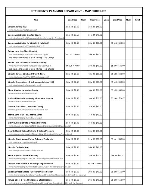
CITY COUNTY PLANNING DEPARTMENT - MAP PRICE LIST<br />
<strong>Map</strong> Size/<strong>Price</strong> Quan Size/<strong>Price</strong> Quan Size/<strong>Price</strong> Quan Total<br />
<strong>Lincoln</strong> Zoning <strong>Map</strong><br />
m:\plots\develop\pdf\Zoning.pdf<br />
8.5 x 11 $7.50 35 x 43 $15.00<br />
Zoning Jurisdiction <strong>Map</strong> for <strong>County</strong><br />
m:\plots\develop\pdf\ZoningJurisdictionsIn<strong>Lancaster</strong><strong>County</strong>.pdf<br />
8.5 x 11 $7.50 31 x 44 $40.00<br />
Zoning Jurisdiction for <strong>Lincoln</strong> (3 mile limit)<br />
m:\plots\develop\pdf\ThreeMileLimit.pdf<br />
8.5 x 11 $7.50 30 x 36 $30.00 35 x 42 $40.00<br />
Future Land Use <strong>Map</strong> (<strong>Lincoln</strong>)<br />
m:\plots\develop\pdf\FutureLandUse-<strong>City</strong>.pdf<br />
We have extra copies <strong>of</strong> 8.5 x 11 map - No Charge<br />
17 x 22 $30.00 35 x 44 $40.00<br />
Future Land Use <strong>Map</strong> (<strong>Lancaster</strong> <strong>County</strong>)<br />
m:\plots\develop\pdf\FutureLandUse-<strong>County</strong>.pdf<br />
We have extra copies <strong>of</strong> 8.5 x 11 map - No Charge<br />
17 x 29 $30.00 28 x 48 $40.00 35 x 60 $50.00<br />
<strong>Lincoln</strong> Service Limit and Growth Tiers<br />
m:\plots\develop\pdf\Tier123PriorityAreas.pdf<br />
8.5 x 11 $7.50 18 x 28 $30.00 35 x 55 $40.00<br />
<strong>Lincoln</strong> Annexations - 5 Yr Increments from 1960<br />
m:\plots\develop\pdf\annexations.pdf<br />
8.5 x 11 $7.50 30 x 36 $30.00 35 x 45 $40.00<br />
Flood <strong>Map</strong> for <strong>Lancaster</strong> <strong>County</strong><br />
m:\plots\natres\pdf\Floodplain.pdf<br />
8.5 x 11 $7.50 18 x 30 $30.00 35 x 59 $50.00<br />
National Wetlands Inventory - <strong>Lancaster</strong> <strong>County</strong><br />
m:\plots\natres\pdf\wetlands.pdf<br />
8.5 x 11 $7.50 18 x 30 $30.00 35 x 60 $50.00<br />
Census Tract <strong>Map</strong> - <strong>Lancaster</strong> <strong>County</strong><br />
m:\plots\georef\refbase\pdf\CensusTracts.pdf<br />
8.5 x 11 $7.50 34 x 38 $40.00<br />
Traffic Zone <strong>Map</strong> - 502 Traffic Zones<br />
m:\plots\transpor\pdf\TrafficZones.pdf<br />
8.5 x 11 $7.50 34 x 38 $40.00<br />
<strong>City</strong> Council Districts & Voting Precincts 8.5 x 11 $7.50 35 x 40 $40.00<br />
m:\plots\georef\refbase\pdf\<strong>City</strong>CouncilDistrictswithVotingPrecincts.pdf<br />
<strong>County</strong> Board Voting Districts & Voting Precincts 8.5 x 11 $7.50 35 x 40 $40.00<br />
m:\plots\georef\refbase\pdf\<strong>County</strong>BoardDistrictswithVotingPrecincts.pdf<br />
<strong>Lincoln</strong> Street <strong>Map</strong> w/Parks, Schools, Trails, etc.<br />
m:\plots\transpor\pdf\streets.pdf<br />
8.5 x 11 $7.50 31 x 36 $30.00 36 x 41 $40.00<br />
<strong>Lincoln</strong> Zip Code <strong>Map</strong><br />
m:\plots\georef\refbase\pdf\zipcode.pdf<br />
8.5 x 11 $7.50 35 x 40 $40.00<br />
Trails <strong>Map</strong> for <strong>Lincoln</strong> & Vicinity<br />
m:\plots\transpor\pdf\MultiUseTrails&BicycleFacilitiesPlan.pdf<br />
8.5 x 11 $7.50 18 x 23 $30.00 35 x 45 $40.00<br />
<strong>Lincoln</strong> Area Streets & Roadways Improvements 8.5 x 11 $7.50 36 x 46 $40.00<br />
m:\plots\transpor\pdf\Projects&Studies_Future RoadImprovements.pdf<br />
Existing Street & Road Functional Classification 8.5 x 11 $7.50 26 x 45 $40.00 35 x 60 $50.00<br />
m:\plots\transpor\pdf\NationalFunctionalStreet&RoadClassification_<strong>City</strong>.pdf (or <strong>County</strong>)<br />
Future Street & Road Functional Classification 8.5 x 11 $7.50 26 x 45 $40.00 35 x 60 $50.00<br />
m:\plots\transpor\pdf\2030FunctionalStreet&RoadClassification_<strong>City</strong>.pdf (or <strong>County</strong>)
CITY COUNTY PLANNING DEPARTMENT - MAP PRICE LIST<br />
<strong>Map</strong> Size/<strong>Price</strong> Quan Size/<strong>Price</strong> Quan Size/<strong>Price</strong> Quan Total<br />
Airport Zoning <strong>Map</strong><br />
m:\plots\transpor\pdf\AirportEnvironsZoningDistrict.pdf<br />
8.5 x 11 $7.50 24 x 30 $30.00 35 x 45 $40.00<br />
Airport Noise Regulation <strong>Map</strong><br />
m:\plots\transpor\pdf\AirportEnvironsNoiseDistrict.pdf<br />
8.5 x 11 $7.50 24 x 30 $30.00 35 x 45 $40.00<br />
<strong>Lincoln</strong> Flood Standards Application Area<br />
m:\plots\natres\pdf\FLoodStandards<strong>Lincoln</strong>.pdf<br />
8.5 x 11 $7.50 35 x 50 $40.00<br />
Homeowners Associations<br />
m:\plots\housing\pdf\homownrs.pdf<br />
8.5 x 11 $7.50 25 x 32 $30.00 36 x 46 $40.00<br />
* Residential Land Inventory Review <strong>Map</strong>s 35 x 40 $40.00<br />
m:\plan\plots\develop\pdf\(geographic area)vac.pdf<br />
5 <strong>Map</strong>s in Series<br />
Per <strong>Map</strong><br />
** Sectional <strong>Map</strong>s - Landbase 35 x 31 $30.00<br />
I:\<strong>City</strong>\Planning\Sectionals\l(section #).pdf<br />
Labels on existing Planning Commission projects...$30.00 plus $.02 per label (Non-PC Projects $60.00 plus $.02 per label)<br />
Scan Oversize Plans ... $10.00 first sheet plus $5.00 per subsequent sheet per project<br />
Print Oversize Plans (Previously Scanned) ... $15.00 per sheet<br />
Scan & Print Oversize Plans ... $25.00 per sheet<br />
Any Special Request <strong>Map</strong>s $60.00 per hour with a minimum charge <strong>of</strong> $60.00 Describe request below...<br />
I understand that maps and/or data contain the best available information but may not be survey accurate.<br />
NAME: DATE: SUBTOTAL:<br />
PHONE: TAX @ 7.0%<br />
EMAIL: TOTAL:<br />
SIGNATURE:<br />
* <strong>Map</strong> NOT available for download on <strong>Map</strong>shop 4033.01 <strong>GIS</strong> Hard Copy <strong>Map</strong>s<br />
** Available on Development Viewer 06047.4012 <strong>GIS</strong> Digital Data<br />
F:files\planning\gis\mapsales.123 (Updated 09/26/11)