

ANDERSSON, C - Association of Canada
ANDERSSON, C - Association of Canada
ANDERSSON, C - Association of Canada

You also want an ePaper? Increase the reach of your titles
YUMPU automatically turns print PDFs into web optimized ePapers that Google loves.
The Wayfarer’s Bookshop<br />
British Columbia<br />
with the Arctic, the Pacific Northwest,<br />
and Western <strong>Canada</strong><br />
Catalogue September 2012<br />
1
The Wayfarer’s Bookshop<br />
British Columbia<br />
with the Arctic, the Pacific Northwest,<br />
and Western <strong>Canada</strong><br />
Catalogue September 2012<br />
www.wayfarersbookshop.com; e-mail: wayfarers@shaw.ca<br />
phone: +1 (604) 921 4196; fax: +1 (604) 921 4197<br />
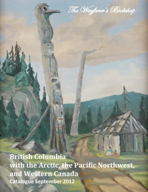
Cover illustration – Oil painting <strong>of</strong> West Coast Totem Poles<br />
and a Native Village, possibly by J. C. Pendray (item # 23)<br />
2
1. [19TH CENTURY GRAND BANKS FISHERIES]<br />
[MCINTOSH, Roderick, Captain] (1845-?)<br />
[Manuscript Journal <strong>of</strong> the Voyage <strong>of</strong> the Fishing Schooner Ocean From Provincetown, New<br />
England, to the Grand Banks <strong>of</strong> Newfoundland, May 15 - Sept 29, 1867, Titled]: Journal <strong>of</strong> a Voyage<br />
from Provincetown to the Grand Banks.<br />
[At sea], 1867. Octavo (20,5x16 cm). [38, 1] leaves. Ruled. Ink on laid paper, in legible hand writing.<br />
Period style brown quarter sheep with marbled boards using original end papers. Some minor scattered<br />
foxing, otherwise a very good manuscript.<br />
1<br />
A rare journal <strong>of</strong> an American commercial fishing voyage, the manuscript notes the weather, the<br />
schooner’s course, and names <strong>of</strong> vessels they met or sighted (including "lots <strong>of</strong> Frenchmen"). At first fish<br />
was "very scarce" (May 27 th , but the next day the Ocean "came across lot <strong>of</strong> Cape Ann men catching<br />
halibut." The entry for the July 10 th when the schooner was at the Virgin Rock noted "Catching fish quite<br />
fast Seen a large fleet <strong>of</strong> vessels to the Southerd, see them coming for us. Lots <strong>of</strong> them anchored<br />
with us"; the note for July 26 th : "All the Doarys come aboard loaded with fish, then we commenced <br />
to make a birth and parted our Chain." The note from August 19 th : "Got our Anchor and stood to the<br />
Westerd in company with the John Simons. Struck the fish and came to an Anchor." The vessels started<br />
returning home in the middle <strong>of</strong> September: Mary E. Nason and Almira Cloughtman on the 15 th , and the<br />
Ocean itself on the 17 th . The journal ends September 29 th ; it is supplemented with a "Remark for the fish<br />
that we caught on board the Ocean for the year 1867" (2 leaves after the main text).<br />
The Ocean’s journal includes 24 leaves and is followed by a short note on McIntosh’s fishing<br />
schooner Bucephalus which went from Provincetown to the Grand Banks in May 1872 (1 page). Ca. fifteen<br />
pages are occupied by the accounts <strong>of</strong> freight and supply coasts for the merchant schooner Freeman<br />
which was cruising along the coast <strong>of</strong> New England in 1879-1881.<br />
"Roderick McIntosh born in 1845, at Cape Breton, Nova Scotia, was the seventh son <strong>of</strong> Roderick<br />
McIntosh. He has lived in Provincetown since 1862, and since 1866 he has been master <strong>of</strong> vessels"<br />
(History <strong>of</strong> Barnstable County, Massachusetts, 1620-1890/ Ed. By S.L. Deyo. New York, 1890. P. 1004).<br />
The case <strong>of</strong> McIntosh was included in the report <strong>of</strong> the Committee on Claims after he claimed a<br />
compensation <strong>of</strong> expense suffered after he had rescued the master and crew (9 men) <strong>of</strong> the schooner<br />
Astoria <strong>of</strong> Buckport on July 8, 1885. McIntosh, master and owner <strong>of</strong> the schooner Bucephalus <strong>of</strong><br />
Provincetown, was fishing on the Grand Banks <strong>of</strong> Newfoundland. The rescue <strong>of</strong> the crew significantly<br />
changed his schedule, "his voyage was prolonged fifteen days, and he encountered a severe storm, which<br />
damaged his vessel and compelled him to enter a provincial port and repair damages at considerable<br />
expense>" McIntosh claimed USD 346, and the Committee found it "reasonable" and that it should be<br />
3
paid, also noting: "It would appear to be good policy not to discourage acts <strong>of</strong> humanity by failing to<br />
reasonable reimburse the masters and owners <strong>of</strong> vessels for services rendered in saving shipwrecked<br />
crews" (See: Reports <strong>of</strong> Committees <strong>of</strong> the House <strong>of</strong> Representatives for the second session <strong>of</strong> the 49th<br />
Congress, 1886-87: in 3 vols. Vol. 2. Washington, 1887. № 4080).<br />
New York Times from September 12, 1888 informed about loss <strong>of</strong> McIntoch’s schooner Carrie<br />
Bonnell at sea. The schooner "was 96 years old register, was 16 years old and was owned by her Captain<br />
[it] was abandoned at sea in a sinking condition. [McIntoch and his crew <strong>of</strong> 14 men] were taken <strong>of</strong>f<br />
by another Provincetown fisherman and landed at St. Pierre on Sept. 3. They saved all their effects and<br />
gear and set the vessel on fire before they left her."<br />
$1500USD<br />
2. [ALASKA, B.C., CANADIAN ROCKIES, PHOTOGRAPHS]<br />
[Album <strong>of</strong> 147 Original Photographs <strong>of</strong> a Trip Through the American West, Including Scenes in the<br />
Grand Canyon, Alaska, Yukon, Mt. Rainier National Park, Victoria (BC), and Canadian Rockies; [With] 71<br />
Real Photo and Printed Postcards Obtained During the Trip].<br />
1919. Oblong Folio (24x36,5 cm). 48 leaves. In total 220 images including a large panorama (ca.<br />
8,5x24,5 cm or 3 ½ x 9 ¾ in) and a large original photograph (ca. 18,5x12,5 cm or 7x5 in); 112 original<br />
photographs ca. 10x12,5 cm (4 x 4 ¾ in), 35 smaller photographs ca. 4,5x6,5 cm (1 ½ x 2 ½ in), 46 larger<br />
(ca. 8,5x13,5 cm or 3 ½ x 5 ½ in) and 25 smaller (ca. 4,5x7 cm or 1 ¾ x 2 ¾ in) postcards, mounted on black<br />
cardboard leaves. Postcards captioned in negative. With the <strong>of</strong>ficial itinerary <strong>of</strong> the trip from the travel<br />
agent (3 sheets) mounted on the first leaf. Handsome period style black half morocco with moire papered<br />
boards and endpapers, and gilt tooled spine. Several leaves with small tears and chips, not affecting<br />
photographs, one image with minor blue stains <strong>of</strong> the upper margin, a small photo faded, a few images<br />
with minor damage in the corners (the photographs were stuck together and later separated). Overall a<br />
very good album.<br />
An interesting photograph<br />
collection <strong>of</strong> a 1919 summer tour across<br />
the Pacific Northwest and the Rocky<br />
Mountains. As seen from the <strong>of</strong>ficial<br />
travel itinerary included in the album, the<br />
traveller was Howard B. Sprague (93<br />
Binney St., Boston, Mass) who went on an<br />
independent tour organized by a Boston<br />
travel company Raymond & Withromb<br />
Inc. (17 Temple Place).<br />
Sprague left Boston on June 15,<br />
1919 and went to the Grand Canyon; after<br />
that he proceeded to California, spending<br />
several days in the resorts <strong>of</strong> Coronado,<br />
and the Yosemite Valley. Then he headed<br />
to Seattle and Vancouver and on July 12<br />
4<br />
2. Totem poles, Alert Bay<br />
sailed from Vancouver on a Canadian Pacific steamer, according to the "itinerary <strong>of</strong> tour # 37."<br />
Apparently, he went from Victoria, BC to Alert Bay (Vancouver Island), Prince Rupert (mainland BC), and<br />
further along the coast <strong>of</strong> Alaska, visiting Wrangell, Juneau, and Skagway. After that he went inland<br />
through the White Pass and Yukon Route, visited Lake Bennet and Dawson City and probably went down<br />
the Yukon River and the on to Victoria, BC. Sprague returned to Seattle on the 30th <strong>of</strong> July and then<br />
stayed at Mt. Rainier Park for several days. He took a train <strong>of</strong> the Canadian Pacific Railway from
Vancouver to the Canadian Rockies and had several stops on the way - in Sicamous (Shushwap region),<br />
Glacier (Illecillewaet), Lake Louise, Banff and St. Paul (Alberta). He arrived home on the August 30th.<br />
The Alaskan photographs include coastal landscapes with mountains and icebergs, several pictures <strong>of</strong><br />
the narrow-gauge White Pass and Yukon Route Railroad and the international boundary between US and<br />
<strong>Canada</strong>. Especially interesting are two photographs <strong>of</strong> the graves (in Skagway) <strong>of</strong> Jefferson Randolph<br />
"Soapy" Smith (1860-1898), a famous con artist and gangster, and Frank H. Reid (1844 or 1850 - 1898), a<br />
soldier and city engineer, both died in the renowned shootout on Juneau Wharf in Skagway on July 8, 1898.<br />
2. Gold dredging operations<br />
Then follow various views <strong>of</strong> Yukon River, Lake Bennet, an image <strong>of</strong> Dawson City; a series <strong>of</strong> ten<br />
photos documenting gold dredging with close up views <strong>of</strong> mills and machines; several riverside scenes<br />
showing bulk <strong>of</strong> logs on shore and their loading to the ship; there is a picture <strong>of</strong> a river steamer Casca<br />
from Victoria, images <strong>of</strong> Victoria Legislature Building and CPR Empress Hotel et al.<br />
Grand Canyon views include a photograph, which apparently, is a portrait <strong>of</strong> Sprague himself,<br />
posing on a cliff, a photo <strong>of</strong> the traveller’s camp, and an interesting series <strong>of</strong> cowboy’s competition. A<br />
couple <strong>of</strong> photographs show scenes <strong>of</strong> hiking on Mt. Rainier and various mountainous landscapes,<br />
including nicely executed panorama and a large view <strong>of</strong> Mt. Rainier. The Canadian Rockies are<br />
represented with a view <strong>of</strong> the Great Divide between BC and<br />
Alberta, pictures <strong>of</strong> a bison and a wolf, and a series <strong>of</strong> over 20<br />
photos <strong>of</strong> Lake Louise and Banff, including views <strong>of</strong> the Lake Louise,<br />
Bow River, and CPR hotel Chateau Lake Louise (one <strong>of</strong> the images<br />
show guests relaxing in the outdoor swimming pool).<br />
The postcards (62 real photo and 9 printed) include 9 views <strong>of</strong><br />
the Indian settlement in Alert Bay with its renowned totem poles (also<br />
represented with two photos); views <strong>of</strong> Victoria and Prince Rupert<br />
(B.C.), Alaskan coast, Wrangell, Ketchikan, Juneau, Skagway, White<br />
Pass and Yukon Route, Canadian dredges on Klondyke River and<br />
Bonanza Creek; a scene with a dog sledge entitled "The Malamute<br />
Chorus" et al. Series <strong>of</strong> postcards <strong>of</strong> Mt. Rainier (32) include images <strong>of</strong><br />
Paradise Inn hotel (completely covered with snow) and restaurant<br />
"Ohop Bob" - a place <strong>of</strong> fine dining on the way to the mountain (it was<br />
built in 1914 for the Tacoma Automobile Club and burned down in<br />
1965). The Canadian Rockies are shown with views <strong>of</strong> "Sir Donald, Uto<br />
and Eagle Peaks" (Glacier Park), Lakes Moraine and Louise.<br />
2. Itinerary <strong>of</strong> the trip<br />
$3250USD<br />
5
3. [ALASKA, PHOTOGRAPHS, POSTCARDS AND EPHEMERA]<br />
[Unique Collection <strong>of</strong> 215 Postcards and Photographs <strong>of</strong> Alaska, including 15 Original<br />
Photographs <strong>of</strong> the US Coast Guard Cutter Haida and its Crew, 138 Real Photo Postcards, and 62 Printed<br />
Postcards; With 8 Pieces <strong>of</strong> Alaskan and North Pacific Related Ephemera].<br />
[Alaska], ca. 1900-1930. Photographs and postcards all ca. 9x14 cm (3 ½ x 5 ½ in). Many captioned<br />
in negative, ca. 50 images captioned and annotated in ink on recto or verso by the same person, most<br />
likely a crew member <strong>of</strong> USCG Haida. Clean and strong postcards, with only less than ten used, one<br />
postcard strengthened on margins. All ephemera in very good condition (see detailed description below).<br />
Overall a great collection in very good condition.<br />
COLLECTION OF A USCG HAIDA’S CREW MEMBER.<br />
Unique collection <strong>of</strong> early and rare postcards and ephemera <strong>of</strong> Alaskan views, scenes and types.<br />
A collection most likely assembled by a crew member <strong>of</strong> the US Coast Guard Cutter Haida, who<br />
captioned and annotated ca. 50 images. A postcard from the collection with the text written in the same<br />
or very similar hand, has been sent from Petersburg, Alaska, on July 30, 1921 (dated and stamped) to<br />
"Miss C. Little" in Ireland; the sender "Bruce" informed that "We arrived here today & will stop for a short<br />
time This is another fishing & mining town, also a lumber depo" (most likely, the sender put together<br />
the collection).<br />
3<br />
The collection <strong>of</strong> annotated images includes 15 original photographs, showing USCG Haida and its<br />
crew, including the cutter’s Captain Shea with his dog, chief wireless operator Fanning, chief machinists<br />
Browning and Jones, "race boats crew this year," "baseball team this year," "hunting party," "reindeer and<br />
one <strong>of</strong> the crew" et al; three images show natives <strong>of</strong> St. Lawrence Island on the deck <strong>of</strong> USS Bear; three<br />
photographs depict a naval (or military) formation in the Unalaska dock; and there is also a photo <strong>of</strong><br />
"Senator Dill & Secretary" on board a ship.<br />
The postcards from the "Haida" collection include a picture <strong>of</strong> cutter Haida itself, and <strong>of</strong> other<br />
vessels, for example USS Bear, Hudson’s Bay Company’s ship Baichimo (before it became a ghost ship;<br />
with an interesting note on verso), "a passenger ship," a shipwreck, a view <strong>of</strong> the deck <strong>of</strong> a schooner and a<br />
6
native kayak next to it et all. There are six postcards<br />
with the scenes <strong>of</strong> whaling, five showing Kodiak bears,<br />
hunted or caught (with manuscript captions, like<br />
"Prisoners <strong>of</strong> war," "This young bear will never roam<br />
the wilderness" et al, and extent notes), and pictures<br />
showing local fishermen and walrus hunters, native way<br />
<strong>of</strong> drying salmon, a portrait <strong>of</strong> Alaskan prospector with<br />
inscription "One <strong>of</strong> the men who made Alaska," two<br />
portraits <strong>of</strong> the natives <strong>of</strong> Northern Siberia, two images<br />
<strong>of</strong> Alaskan kayaks, a portrait <strong>of</strong> an "Indian slave" et al.<br />
Postcards showing Alaskan cities and scenery<br />
include a series <strong>of</strong> five very interesting views showing<br />
the parade on the 4th <strong>of</strong> July in Seward, and a group <strong>of</strong><br />
views <strong>of</strong> the Aleutian Islands, with six pictures <strong>of</strong><br />
Unalaska (including images <strong>of</strong> the Russian Orthodox<br />
church and Orthodox service in Unalaska), and two<br />
views <strong>of</strong> the native huts on the Unimak and Akutan Islands.<br />
7<br />
3. Whaling scenes<br />
The manuscript notes and captions are usually very informative, sometimes humorous, but always<br />
interesting. See the extensive note on the verso <strong>of</strong> the postcard captioned "Captain Hanson" and showing<br />
hunters cutting a walrus on board a schooner:<br />
"This is the schooner that rescued the<br />
last survivors <strong>of</strong> the American expedition to<br />
Wrangell Island. They found the remains <strong>of</strong> all<br />
the men dead with several unfinished diaries.<br />
The man on the left if Captain Hanson, a<br />
Dane. He was telling me all about he found<br />
one Eskimo girl alive and feeling fine in the<br />
gruesome surroundings, the only survivor, the<br />
famous Ada Blackjack. He said he showed her<br />
the time <strong>of</strong> her life afterwards for many<br />
nights. I never laughed so much as to hear<br />
that old reprobate tell <strong>of</strong> his experience. He<br />
said that he had it to say he slept with the<br />
most famous woman in the world. That was<br />
his way <strong>of</strong> treating the sole survivor. Hanson is<br />
3. A photo <strong>of</strong> Captain Hanson<br />
quite a character, an old sailing ship man who might have been a great man, but he is so lawless wrecker."<br />
USCGC Haida (WPG-45) was a 240-foot Tampa-class United States Coast Guard cutter in<br />
commission from 1921 until 1947. Haida was first stationed at Seattle, Washington and began a<br />
peacetime career on the annual Bering Sea Patrols. She first sailed to Unalaska, the headquarters for the<br />
Patrol, and then sailed on her assigned tasks, which included acting as a floating court for the inhabitants<br />
<strong>of</strong> the isolated areas she sailed, caring for the sick, conducting search and rescue activities, checking on<br />
aids to navigation, regulating fisheries, and other duties. With Prohibition being the law <strong>of</strong> the land after<br />
the passage <strong>of</strong> the Volstead Act in 1919, the Haida and her sister cutters became the main enforcement<br />
arm <strong>of</strong> the federal government's effort to prevent liquor smuggling at sea, thereby adding another duty to<br />
an already full plate. Haida apparently had little luck in stopping any smuggling but nevertheless<br />
continued to carry out her other tasks. In 1924 Haida, in concert with the cutter Algonquin, sailed in<br />
support <strong>of</strong> the U.S. Army's World Flight, the first attempt to circumnavigate the globe by air (United<br />
States Coast Guards on-line).
REAL PHOTO POSTCARDS<br />
The postcards <strong>of</strong> Alaskan cities and landscapes include four views <strong>of</strong> the Kodiak Archipelago with<br />
three views <strong>of</strong> Kodiak (public school, Kodiak Cannery and US Experiment Station in the Kalsin Bay, 14 m.<br />
From Kodiak), and a view <strong>of</strong> the Letnik Lake on Afognak Island, pictures <strong>of</strong> Seward (3), Nome (two,<br />
including a picture <strong>of</strong> the city fire in 1934), Valdez (2), Dutch Harbour next to Unalaska, Cordova,<br />
Kennecott, Tanana Valley Railroad, Mt. Hood, McCarty Glacier, and Aurora Borealis in Alaska.<br />
Over 30 postcards represent portraits <strong>of</strong> the natives, including types <strong>of</strong> fur dealers, hunters, basket<br />
weavers, berry pickers, women, children, "Eskimo in Rain suit," views <strong>of</strong> totem poles, kayaks, interiors <strong>of</strong><br />
huts, a portrait <strong>of</strong> "Big Chief Affannassia" et al. Four postcards show various ships (USS Algonquin, a cutter<br />
in Bering Sea, wreck <strong>of</strong> SS Mariposa, and a schooner from Nome), one postcard represent a mascot <strong>of</strong> USS<br />
Bear (a goat). There are nine postcards with whaling, hunting and fishing scenes (including a series <strong>of</strong><br />
images about whaling in Kodiak, views <strong>of</strong> seal poaching ships in Unalaska and "Shark fishing" et al). 17<br />
postcards show Alaskan animals and birds: Kodiak bears (5), fur seals, foxes, moose, spider crab, rock cod,<br />
musk ox, Alaska eagle et al.<br />
11 postcards show the American settlers <strong>of</strong> Alaska and their occupations: the <strong>of</strong>ficial group portrait<br />
<strong>of</strong> Alaskan authorities (US President Warren Harding, Alaskan Governor Scott Cordell Bone, Secretary <strong>of</strong><br />
Commerce Herbert Hoover and others), a portrait <strong>of</strong> American pioneer pilot Parker D. Cramer next to his<br />
plane, a "Hawaiian" style portrait <strong>of</strong> a man having sun tan in the winter Alaskan landscape; several<br />
pictures <strong>of</strong> women and children ("Raising goats in Alaska," "Rosebuds in the North") et al.<br />
PRINTED POSTCARDS<br />
Printed postcards (52 colour and 10 black and white) include views <strong>of</strong> Alaskan cities and<br />
settlements: Nome (4, including scenes <strong>of</strong> landing passengers in Nome, and US Mail Team), Unalaska (3),<br />
Valdez (3), Skagway (2), Cordova (2, including views <strong>of</strong> Copper River and Northwest Railway), Seward,<br />
Hadley, Circle City, Chena Slough and Fairbanks, and Bluff City; four postcards show Canadian cities<br />
Dawson (2) and White Horse (2). Alaskan landscapes are represented with pictures <strong>of</strong> Cape Rodney, Cape<br />
8<br />
3
Prince <strong>of</strong> Wales, Yukon River (4, including views <strong>of</strong> Fort Gibbon Weare and Tanana), Thompson Pass,<br />
White Pass Summit (2), Muir Glacier, Taku Glacier (2 cards, one stamped "Skagway, Alaska, May 5, 1906<br />
[?]"), a view <strong>of</strong> "Work train at Mile 113 <strong>of</strong> Copper River and Northwest Ry." et al.<br />
13 postcards show types <strong>of</strong> Alaskan natives, including portraits <strong>of</strong> reindeer herders on Cape Prince <strong>of</strong><br />
Wales, "Native packer," "An Eskimo smoker," a portrait <strong>of</strong> a native woman called Jaorge-Sha-Wut, women<br />
selling berries in Sitka, carrying children, weaving baskets, "Eskimo Mickaninnies on Parade," a view <strong>of</strong> an<br />
Indian camp, four views <strong>of</strong> the totem poles (including those in Alert Bay <strong>of</strong> Vancouver Island) et al.<br />
3. Printed postcards and ephemera from the collection<br />
A series <strong>of</strong> postcards dedicated to Alaskan gold mining industry include three Nome scenes (a<br />
portrait <strong>of</strong> prospectors, "shovelling on Buster Creek" and "Dredging for gold"); two views <strong>of</strong> Douglass<br />
Island (showing the Treadwell Mine and Mexican and Ready Bullion Mines), a view <strong>of</strong> the main dining<br />
room <strong>of</strong> the Treadwell Mine’s Boarding House; "Typical miner’s cabin," and a card showing several piles <strong>of</strong><br />
gold sand and entitled "$ 150,000. One Day’s Sluicing Discovery, Little Creek."<br />
A colour postcard shows Reverend Wm. Duncan, founder <strong>of</strong> the Native mission in Metlakatla.<br />
The majority <strong>of</strong> the printed postcards were issued by Portland Post Card Co. (28); Lowman &<br />
Hanford Co., Seattle (9); E.H. Mitchell, San Francisco (7); HHT Co. (4); but also there are 7 postcards<br />
published by small Alaskan or Canadian entrepreneurs: from Juneau (W.H. Case, Purity Pharmacy),<br />
Cordova (O. Kennedy, Cordova Drugs Co.), Nome (B.B. Dobbs, Photographic Supply Stores), Dawson<br />
(Zaccarelli’s Book Store). Several postcards were issued by New York (Albertype Co., the Photograph Co.),<br />
and Lyon (prototype Levenq & Cottin) companies.<br />
One <strong>of</strong> the card showing White Horse is supplemented with a vivid text: "Dear Mother, I am now in<br />
Yukon, I have not yet picked up any gold. It is fearfully open and cold. I have now travelled over 9000<br />
miles by train from Quebec. Yours truly, Percy John Tyson" (addressed to London, 1909).<br />
9
EPHEMERA<br />
The ephemera includes:<br />
A Few Facts Concerning the Development <strong>of</strong> Alaska and Siberia [An advertising brochure]/<br />
Northwest Commercial Company. Seattle, [1906]. Oblong Octavo (15,5x23 cm). [32] pp., ill., maps.<br />
Original publisher’s illustrated wrappers, slightly soiled. A very good copy.<br />
Your Vacation should Include Yellowstone Park, Lewis and Clark Exposition, Alaska, one or all<br />
[Advertising]/ Northern Pacific Yellowstone Park Line// McClure’s Magazine, April 1905. Octavo (24,5x16<br />
cm). Very good. The advertising shows a native woman <strong>of</strong> the Pacific Northwest with two children, sledge<br />
dogs and a totem pole in the background.<br />
Two coloured lithographs representing types <strong>of</strong> natives <strong>of</strong> Unalaska, Aleutian and Kurile Islands,<br />
and "Isole delle Volpi," Plates 67 and 68 from "Asia Settentrionale" (1841). Large octavo (28x20 cm). Very<br />
good, bright lithographs.<br />
Front wrapper <strong>of</strong> the magazine "The Open Road for Boys" (April 1937), by H.L.V. Parkhurst, showing<br />
a pilot and a woman passenger flying low over Alaskan mountains and valleys, the heading "The Gold<br />
Gulch Flight: Alaskan Air Adventure." Quarto (29x21 cm), very good.<br />
Two collectable cards, # 24 and 71, entitled "Alaska" and sold with c<strong>of</strong>fee <strong>of</strong> Arbuckle Bros., New<br />
York. 1889-1893. Both ca. 7,5x12,5 cm. Very good. The cards show the map <strong>of</strong> Alaska, and several scenes<br />
<strong>of</strong> local life (seals resting on the ice, whalers, hunters, natives), one card with the description <strong>of</strong> Alaska on<br />
verso.<br />
A collectable card entitled "Ausser-Europäische Wasserstrassen. Bering-Strasse" and sold with<br />
Liebig’s Fleisch-Extract (broth), Germany. Ca. 1890-1910-s. Ca. 7x11 cm. Very good. The card shows map<br />
and <strong>of</strong> view <strong>of</strong> Bering Strait, and a portrait <strong>of</strong> the native "Eskimo."<br />
$8250USD<br />
4. [ALEXANDER VON BUNGE EXPEDITION 1889]<br />
[Unique Collection <strong>of</strong> 23 Original Photographs Documenting the Investigation <strong>of</strong> the Wreck <strong>of</strong> the<br />
Russian Coast Guard Ship Kreiserok in the Vicinity <strong>of</strong> Cape Soya, Northwestern Hokkaido].<br />
Ca. 1889. One photograph ca. 16.5 x 22cm (6.5 x 8.5 in), eighteen photographs, ca. 12x17 cm (4 ¾<br />
x 6 ¾ in) and four smaller photographic portraits <strong>of</strong> the Kreiser’s crew, ca. 11x8 cm (4 ¼ x 3 ¼ in)<br />
mounted on card leaves <strong>of</strong> different sizes. The majority <strong>of</strong> photographs with pencil captions in Danish<br />
on the lower margins <strong>of</strong> the mounts. Minor foxing <strong>of</strong> the mounts, but overall a very good collection.<br />
This important photographic collection<br />
documents the search expedition <strong>of</strong> the<br />
Russian Navy to the northwestern Hokkaido in<br />
November 1889 - January 1890. The purpose<br />
was to investigate the fate <strong>of</strong> the shipwreck <strong>of</strong><br />
the Russian coast guard schooner Kreiserok<br />
("Little Cruiser") which was in service on the<br />
coast <strong>of</strong> Tyuleniy Island (in the Sea <strong>of</strong> Okhotsk,<br />
19 km to the south <strong>of</strong> Cape Patience (Mys<br />
Terpeniya), on the eastern Sakhalin coast)<br />
protecting against poachers and disappeared<br />
in a storm on October 26, 1889.<br />
The wreck <strong>of</strong> Kreiserok was discovered<br />
by Japanese on the shore next to village<br />
Wakkanai, in the vicinity <strong>of</strong> Cape Soya,<br />
10<br />
4. Alexander Bunge (bottom row, first from<br />
left) and members <strong>of</strong> his expedition
the northernmost point <strong>of</strong> Hokkaido, 43 km away across the Laperouse Strait from Sakhalin Island. The<br />
Russian consulate informed the Pacific Squadron <strong>of</strong> the Russian Navy which wintered in Nagasaki, and the<br />
Squadron Commander rear admiral Vladimir Schmidt sent the investigation expedition on clipper Kreiser<br />
("Cruiser") to ascertain whether the wreck was indeed the Kreiserok.<br />
The expedition under the leadership<br />
<strong>of</strong> renowned Russian Polar explorer, doctor<br />
Alexander von Bunge (1851-1930) included<br />
Lt. V.N. Bukharin and other Russian<br />
mariners, as well as Japanese <strong>of</strong>ficials and<br />
translators. The party reached the place <strong>of</strong><br />
the wreck with great difficulties because <strong>of</strong><br />
heavy snowfalls and strong winds. They<br />
examined what left <strong>of</strong> the schooner - a part<br />
<strong>of</strong> stern with steering wheel and the right<br />
side with both masts. Two ship’s boats, the<br />
flag and the board with the ship’s name<br />
were discovered, as well as a body <strong>of</strong> a sailor<br />
(Fedor Ivanov). None <strong>of</strong> the crew members<br />
4. Kreiserok's wreck, with (likely) Lt.<br />
Bukharin and Lt. Cold in the centre<br />
11<br />
was rescued, obviously there were no<br />
survivors. The cause <strong>of</strong> the disaster wasn’t<br />
determined, but it was assumed that the ship<br />
wrecked because <strong>of</strong> the ice formation on Kreiserok’s hull and rigging during strong storm, winds and low<br />
temperatures.<br />
This photograph collection, assembled<br />
by the Danish member <strong>of</strong> Kreiser’s crew, Lt.<br />
C.M.T. Cold (who also captioned most <strong>of</strong> the<br />
images), includes eleven images <strong>of</strong> the<br />
Kreiserok wreck on shore with all parts <strong>of</strong> the<br />
schooner's remains clearly visible. Five images<br />
show the surrounding coast and a Japanese<br />
settlement, covered with deep snow. The<br />
majority <strong>of</strong> the pictures from the wreckage<br />
also show the expedition members, with<br />
Alexander Bunge present on five pictures, and<br />
possibly V. Bukharin and Lt. Cold present at<br />
least on six pictures; several pictures show the<br />
Japanese members, and two images are group<br />
portraits <strong>of</strong> all expedition members. Five<br />
pictures are dedicated to the clipper Kreiser<br />
4. Kreiserok's wreck; Bunge first from left<br />
including four portraits <strong>of</strong> its crew members, and a view <strong>of</strong> Kreiser in the harbour <strong>of</strong> Nagasaki, the latter<br />
was reproduced in: Krestianinov, V.I. Cruisers <strong>of</strong> the Russian Imperial Navy, 1856-1917. Part 1. SPb., 2003<br />
(Крестьянинов, В.Я. Крейсера Российского Императорского флота, 1856-1917. Ч. I. СПб, 2003).<br />
The monument erected in 1897 in Vladivostok in memory <strong>of</strong> Kreiserok and its crew became the first<br />
monument <strong>of</strong> Vladivostok and the first <strong>of</strong>ficial memorial on the Pacific to Russian naval mariners who<br />
perished on duty.<br />
Kreiserok ("Little Cruiser") was a coast guard schooner <strong>of</strong> the Russian Imperial Navy. Tonnage 15 t.,<br />
length 24 m., width 8 m., draught 2.13 m. Built in 1884 in Seattle, before 1886 – American schooner<br />
"Henrietta." In 1886 it was confiscated by the Russian clipper "Kreiser" for poaching in the Russian waters
<strong>of</strong> the Bering Sea. In 1887 under command <strong>of</strong> lieutenant Tsvangman it carried out hydrographical survey<br />
<strong>of</strong> the Amur estuary. On May 14, 1888 it was renamed after the clipper "Kreiser" and became a coast<br />
guard vessel <strong>of</strong> the Tyuleniy Island (the Sea <strong>of</strong> Okhotsk). In October 1889 during its service on the island’s<br />
coast it captured American poaching schooner Rose and prepared to escort it to Vladivostok, but instead<br />
wrecked in a storm with the entire crew perishing. A cape and a bay in the Possiet Gulf (Peter the Great<br />
Gulf <strong>of</strong> the Sea <strong>of</strong> Japan) were named after it.<br />
Alexander von Bunge was a renowned Russian Polar explorer, doctor <strong>of</strong> medicine and zoologist, a<br />
son <strong>of</strong> famous botanist Alexander von Bunge (1803-1890). He participated in the expeditions to the<br />
mouth <strong>of</strong> the River Lena (1882-84), Yenisey River (1892-95), Spitsbergen (1900) et al; he headed the<br />
expedition to the New Siberian Islands (1885-86). Von Bunge’s meteorological observations were used by<br />
F. Nansen during his famous Fram expedition. An island in the Arctic Ocean (Bunge Land), a peninsula on<br />
the Russky Island (Nordenskiöld Archipelago), glaciers on Spitsbergen and Novaya Zemlya, and a<br />
mountain on Spitsbergen were named after him.<br />
$5750USD<br />
5. [AMERICAN FUR COMPANY’S VOYAGEUR CONTRACT]<br />
[A Signed Contract Engaging Jean Sonnet <strong>of</strong> Montreal or La Prairie with W.W. Matthews for Two<br />
Winters to Perform Various Tasks, Including Barrel Making].<br />
Montreal: 17 March, 1818. One page folio (32x20 cm). Printed document in French, filled out in<br />
manuscript; laid paper. Margins with a couple <strong>of</strong> minor tears, otherwise a very good document.<br />
A contract between William Wallace Mathews, a<br />
manager <strong>of</strong> the American Fur Company from Montreal, and a<br />
local man Jean Sonnet who promised to "well and properly care<br />
for the roads and being at the said place, goods, food, pelts,<br />
utensils at all things necessary for the journey; serve, obey and<br />
execute loyalty to the said Sir." Sonnet was entitled to the<br />
wages <strong>of</strong> 900 livres, ten piastres and some equipment in<br />
advance. Jean Sonnet has signed with an “X”.<br />
"In 1817-18, the American Fur Company brought a large<br />
number <strong>of</strong> clerks from Montreal and the United States to<br />
Mackinaw, some <strong>of</strong> whom made good Indian traders, while<br />
many others failed upon trial and were discharged. <br />
To William Mathews was entrusted the engaging <strong>of</strong><br />
voyageurs and clerks in <strong>Canada</strong>, with his head-quarters in<br />
Montreal. The voyageurs he took from the habitants (farmers);<br />
young, active, athletic men were sought for, indeed, none but<br />
such were engaged, and they passed under inspection <strong>of</strong> a<br />
surgeon. Mr. M. also purchased at Montreal such goods as<br />
were suited for the trade, to lead his boats. These boats were<br />
the Canadian batteaux, principally used in those days in<br />
transferring goods to upper St. Lawrence river and its<br />
tributaries, manned by four oarsmen and a steersman, capacity about six tons.<br />
The voyageurs and clerks were under indentures for a term <strong>of</strong> five years. Wages for voyageurs,<br />
$100, clerk from $120 to $500 per annum. These were all novices in the business; the plan <strong>of</strong> the<br />
company was to arrange and secure the services <strong>of</strong> old traders and their voyageurs, who, at the (new)<br />
organization <strong>of</strong> the company were in the Indian country, depending on their influence and knowledge <strong>of</strong><br />
the trade with the Indians; and as fast as possible secure the vast trade in the West and North-West,<br />
12<br />
5
within the district <strong>of</strong> the United States, interspersing the novices brought from <strong>Canada</strong> so as to<br />
consolidate, extend, and monopolize, as far as possible, over the country, the Indian trade.<br />
The first two years they had succeeded in bringing into their employ seven-eights <strong>of</strong> the old Indian<br />
traders on the tributaries as far north as the boundaries <strong>of</strong> the United States extended. The other eighth<br />
thought that their interest was to remain independent; toward such, the company selected their best traders,<br />
and located them in opposition, with instructions so to manage by underselling to bring them to terms"<br />
(Hurlbut, Henry H. Chicago Antiquities: Comprising original items and relations, letters, extracts, and notes<br />
pertaining to early Chicago, embellished with views, portraits, autographs, etc. Chicago, 1881. P. 30-31).<br />
"The American Fur Company (1808-1842) was founded by John Jacob Astor and by 1830 grew to<br />
monopolize the fur trade in the United States, becoming one <strong>of</strong> the largest businesses in the country. The<br />
company was one the first great trusts in American business.<br />
During its heyday, the American Fur Company was one <strong>of</strong> the largest enterprises in the United<br />
States and held a total monopoly <strong>of</strong> the lucrative fur trade in the country. The company provided the<br />
income for the land investments that catapulted John Jacob Astor to the position <strong>of</strong> richest man in the<br />
world and the first multi-millionaire in America. The German-born Astor remains the eighteenth<br />
wealthiest person <strong>of</strong> all time, and the eighth to create that fortune in the United States. He used part <strong>of</strong><br />
his fortune to found the Astor Library in New York City. Later it merged with the Lenox Library to form the<br />
New York Public Library.<br />
On the frontier, the American Fur Company opened the way for the settlement and economic<br />
development <strong>of</strong> the Midwestern and Western United States. Mountain men working for the company<br />
improved Native American trails and carved others that led settlers into the West. Many cities in the<br />
Midwest and West, such as Astoria, Oregon and Fort Benton, Montana, developed around American Fur<br />
Company trading posts. The American Fur Company played a major role in the development and<br />
expansion <strong>of</strong> the young United States" (Wikipedia).<br />
See also: Matthew’s Adventures in the Columbia: A Pacific Fur Company Document/ Ed. By J.E.<br />
Douglas// Oregon Historical Quarterly. Vol. 40. № 2. Jun., 1939. P. 105-148.<br />
$1250USD<br />
6. [ARCTIC EXPLORERS]<br />
"Northesk Admiral; Left London on the 23 May 1829<br />
and returned from the Arctic Regions on the 19th Oct 1833<br />
Ja. Clark.Ross; John Ross; W. Parry, hydrographer."<br />
Ca. 1833. Album sheet, ca. 27x22 cm (10 ½ x 8 ¾ in)<br />
The signatures on paper mounted on a light blue album leaf.<br />
Signatures and album leaf in fine condition.<br />
Album sheet with the signatures <strong>of</strong> Naval commander<br />
Admiral Northesk, and the Arctic explorers: James Clark Ross,<br />
his uncle John Ross, and William Parry.<br />
"Admiral William Carnegie GCB, 7th Earl <strong>of</strong> Northesk<br />
(1756-1831) was born in Hampshire to Admiral George<br />
Carnegie, 6th Earl <strong>of</strong> Northesk and Anne Melville..,<br />
Sir James Clark Ross (1800-1862), was a British naval<br />
<strong>of</strong>ficer and explorer. He explored the Arctic with his uncle Sir<br />
John Ross and Sir William Parry, and later led his own<br />
expedition to Antarctica..,<br />
Sir John Ross, CB, (1777-1856) was a Scottish rear<br />
admiral and Arctic explorer..,<br />
13<br />
6
Sir William Edward Parry (1790-1855) was an English rear-admiral and Arctic explorer, who in 1827<br />
attempted one <strong>of</strong> the earliest expeditions to the North Pole. He reached 82°45′ North latitude, setting the<br />
record for human exploration farthest North that stood for nearly five decades before being surpassed at<br />
83°20′26″ by Albert Hastings Markham in 1875-1876" (Wikipedia)<br />
$1250USD<br />
7. [ARCTIC MEDAL]<br />
[INGRAM, W.]<br />
[An Octagonal Silver Arctic Medal Engraved for W. Ingram, HMS Hecla].<br />
[London], [1857]. Diameter approx. 33 mm. Recto with<br />
pr<strong>of</strong>ile <strong>of</strong> Queen Victoria wearing a tiara and facing left with<br />
words "VICTORIA REGINA" to rim. Reverse with sailing ship and<br />
icebergs in the background and a sledge party in the<br />
foreground; with the dates "1818-1855" under, and the words<br />
"FOR ARCTIC DISCOVERIES" above the scene. The inner edge <strong>of</strong><br />
the rim on both faces is beaded. At the top <strong>of</strong> the medal is a<br />
small claw above which is a five-pointed star with another<br />
smaller five-pointed star <strong>of</strong>fset behind it; on the topmost large<br />
point is a swivel through which is a half inch ring. Three lower<br />
sections on the rim with engraved words "W. INGRAM H.M.S.<br />
HECLA." Medal slightly darkened, complete with suspender,<br />
white ribbon renewed; Overall in near fine condition.<br />
In May 1857, the London Gazette announced the<br />
inception <strong>of</strong> a new medal awarded for Arctic discoveries.<br />
Claimants, who could include those participating in expeditions<br />
<strong>of</strong> discovery and those who had participated in the search for<br />
Sir John Franklin, were invited to apply to the Accountant-<br />
General <strong>of</strong> the Navy, Admiralty, Somerset House in London. A<br />
list <strong>of</strong> expeditions for which claims were eligible was also<br />
printed, and this list was extended to at later dates (to include,<br />
for instance, the Nares Arctic Expedition <strong>of</strong> 1875-6).<br />
The present example bears an inscription relating to W. Ingram, but the attribution is uncertain:<br />
according to Poulsom & Myres, the standard reference work, William Ingram served as a Private R.M. on<br />
the North Star during the time <strong>of</strong> search for Franklin expedition: A medal named to W. Ingram serving on<br />
the HMS Hecla is known to exist, but there is a gap in the ship's records <strong>of</strong> him serving on the Hecla.<br />
Poulsom & Myres p.207.<br />
$2500USD<br />
8. [B.C. – ALASKA – KLONDIKE GOLD RUSH, PHOTOGRAPHS]<br />
[Album <strong>of</strong> 91 Original Photographs <strong>of</strong> Alaska Including Views <strong>of</strong> Sitka, Wrangell, Muir Glacier and<br />
Skagway with the White Pass].<br />
1899. Oblong Folio (28x34,5 cm). 91 photographs, the majority ca. 12x10 cm (4 ¾ x 4 in) or slightly<br />
smaller, mounted on 11 grey card leaves. With two chromolithographs and a coloured photograph by<br />
LaRoche (Seattle) mounted on the endpapers and on the last leaf <strong>of</strong> the album. Several images with period<br />
pencil or ink captions. Period style black full morocco with gilt tooled title and a chromolithograph showing<br />
Yukon tundra in summer, mounted on the front board. First and last leaves with small tears and chips, not<br />
14<br />
7
affecting photographs. Two photos lightly chipped; a few with some minor soiling. Overall a beautiful<br />
album with strong, bright images.<br />
An interesting collection <strong>of</strong> photographs taken during a cruise on the steamship "Queen" along the<br />
Northwest coast <strong>of</strong> America and Alaska in July 1899, during the Klondike Gold Rush 1896-99. The group <strong>of</strong><br />
travellers proceeded from Victoria (British Columbia) and went north and visited Sitka, Wrangell, Glacier<br />
National Park, where they spent time at the Muir Glacier, Skagway and summitted the famous White Pass<br />
leading to the Yukon River and further to the Klondike Gold fields.<br />
The images include Alaskan<br />
scenery (mountains, rivers, coastal<br />
landscapes), including close-up views <strong>of</strong><br />
houses and totem poles in Wrangell,<br />
views <strong>of</strong> the harbour and vicinities <strong>of</strong><br />
Sitka, a nice series <strong>of</strong> the Muir glacier<br />
views, images <strong>of</strong> the interior <strong>of</strong> St.<br />
Michael’s Russian Orthodox Cathedral in<br />
Sitka, the Legislature building in Victoria,<br />
a portrait with the building <strong>of</strong> the<br />
Klondike Trading Company in the<br />
background et al. The images <strong>of</strong> the<br />
tourists themselves show numerous<br />
outdoor activities, such as fishing, hiking,<br />
and mountain climbing, as well as taking<br />
the air on board the steamship. Images <strong>of</strong><br />
note include a photo <strong>of</strong> two ladies in<br />
shirtwaists roped up together for<br />
mountain climbing; two photos <strong>of</strong> bison;<br />
15<br />
8<br />
8. Totem poles in Wrangell<br />
and an image <strong>of</strong> a group <strong>of</strong> native children and their dogs seated on the ground outside a cabin in a<br />
village. A nice record <strong>of</strong> a Victorian pleasure trip to the Far North.<br />
$3250USD
9. [B.C. GOLD RUSH WEEKLY NEWSPAPER]<br />
The Cariboo Sentinel: Vol. 1. No. 12.<br />
Barkerville, Williams Creek, British Columbia: Saturday, August 19, 1865. On a double Elephant Folio<br />
leaf (ca. 40,5x29,5 cm or 16 x 11 ½ in). Four pages. With Two page Supplement laid in. Period pencil note<br />
"30 cops. Exp. Acc. F.J. Barnard" in the right upper corner; blue stamp "M.W. WAITT & Co. Govt. St.<br />
VICTORIA" in the left upper corner. Light staining along fold lines, chipping on the upper edge, but overall<br />
a very good copy.<br />
Very rare as only four runs <strong>of</strong> the<br />
newspaper located in Worldcat.<br />
One <strong>of</strong> the first issues <strong>of</strong> this<br />
almost legendary goldfields newspaper<br />
inscribed by a prominent BC<br />
businessman and politician, the founder<br />
<strong>of</strong> famous Barnard’s Express: Francis<br />
Jones Barnard (1829-1889).<br />
The inscription ordered to send 30<br />
copies <strong>of</strong> the newspaper to the <strong>of</strong>fice <strong>of</strong><br />
a Victoria bookseller, publisher and news<br />
agent M.W. Waitt & Co. (probably, on<br />
Barnard’s personal account). The reason<br />
for this was most likely the article letter<br />
from Victoria written anonymously<br />
by a member <strong>of</strong> the Legislature, which presented a lengthy defense <strong>of</strong> Union <strong>of</strong> the Colonies <strong>of</strong> BC and<br />
Vancouver Island, based partly on the value <strong>of</strong> the Cariboo miners to the Island economy and, reciprocally,<br />
the value <strong>of</strong> free trade to the miners (the union was concluded in 1866).<br />
"The Cariboo Sentinel was published in Barkerville, in the<br />
Cariboo region <strong>of</strong> central British Columbia, and ran from June 1865<br />
to October 1875. At the time, Barkerville was home to a fastgrowing<br />
community <strong>of</strong> miners who had been attracted to the<br />
Cariboo region by the discovery <strong>of</strong> gold. The Sentinel was<br />
published by George Wallace, and its stated objective was not only<br />
to disseminate "mining intelligence," but also to eradicate "<strong>of</strong>ficial<br />
abuse[s]" <strong>of</strong> power, both within the Cariboo region and beyond<br />
(vol. 1, no. 1, p. 2)" (UBC Library Catalogue).<br />
"Francis Jones Barnard, <strong>of</strong>ten known as Frank Barnard Sr.,<br />
was a prominent British Columbia businessman and Member <strong>of</strong><br />
Parliament in <strong>Canada</strong> from 1879 to 1887. Most famously, Barnard<br />
was the founder <strong>of</strong> the B.X. Express freighting company ("Barnard's<br />
9. Article about the Union <strong>of</strong> the Express"), which was the main cartage and passenger services<br />
Colonies <strong>of</strong> Vancouver Island and BC, company on the Cariboo Road. His son, Sir Francis Stillman<br />
with the stamp <strong>of</strong> M.W. Waitt and Co. Barnard, <strong>of</strong>ten known as Frank Barnard Jr., later became the<br />
Lieutenant-Governor <strong>of</strong> British Columbia.<br />
It was his next enterprise, begun in the fall <strong>of</strong> 1860, that would grow to become the B.X. Express<br />
one <strong>of</strong> the most important companies in the early history <strong>of</strong> the Colony, and which would remain in<br />
business for decades. He began by carrying mail and newspapers, on foot, all the way from Yale to the<br />
goldfield towns <strong>of</strong> the Cariboo, a 760-mile roundtrip journey, charging $2 per letter and selling<br />
newspapers in the goldfields for $1 a copy. In 1861 and 1862 he also carried packages between Yale and<br />
New Westminster, a distance <strong>of</strong> 200 miles, and in 1862 established a one-horse pony express, with<br />
16<br />
9
himself as sole rider, serving the Cariboo from Yale, where he met with services from New Westminster<br />
and Yale provided by Dietz & Nelson (one <strong>of</strong> the partners in which was the later Lieutenant-Governor<br />
Hugh Nelson) and couriered reliably from there to Barkerville. On his return journeys, he became<br />
entrusted with shipments <strong>of</strong> gold dust, and managed to reliably and safely convey earnings from the<br />
goldfields to Yale despite the ever-present risk <strong>of</strong> robbery, in addition to the difficulties posed by distance,<br />
climate, and the difficult canyon and plateau trails.<br />
With the completion <strong>of</strong> the first section <strong>of</strong> the Old<br />
Cariboo Road to Soda Creek in 1862 , Barnard used his own<br />
acquired capital and found a backer to launch Barnard's<br />
Express and Stage Line with fourteen six-horse coaches and a<br />
famous team <strong>of</strong> "crack whips" to drive them, including<br />
legendary drivers Steve Tingley and Billy Ballou. The onset <strong>of</strong><br />
the busiest phase <strong>of</strong> movement <strong>of</strong> miners and goods to and<br />
from the Cariboo Gold Rush began that year, and Barnard's<br />
new company prospered from a buys trade in services for<br />
passengers, freight, letters, newspapers and gold dust, and in<br />
1864 was able to expand his business further with the<br />
purchase <strong>of</strong> more rolling stock and also in winning the<br />
government contract to carry the mail. Barnard was also able<br />
to encourage the government to end the gold escort with the<br />
result that his company's coaches, equipped with armed<br />
guardsmen, would be fully in charge <strong>of</strong> the movement <strong>of</strong> gold<br />
17<br />
9. An advertisement in the Cariboo Sentinel<br />
from the Cariboo to the Coast. In 1866 Barnard bought out Dietz and Nelson and so came into control <strong>of</strong><br />
the bulk <strong>of</strong> business connecting Victoria to Barkerville, as he was now in control <strong>of</strong> shipments between<br />
Victoria and Yale as well as from Yale northwards" (Wikipedia).<br />
$1500USD<br />
10. [B.C. TERMS OF UNION WITH CANADA]<br />
[Leaflet Titled]: To the Queen’s Most Excellent Majesty.<br />
Most Gracious Sovereign: We, Your Majesty’s most dutiful and<br />
loyal Subjects, the Members <strong>of</strong> the Legislative Council <strong>of</strong> British<br />
Columbia in Council assembled, humbly approach Your Majesty<br />
for the purpose <strong>of</strong> representing the subject <strong>of</strong> the<br />
admission <strong>of</strong> the Colony <strong>of</strong> British Columbia into the Union or<br />
Dominion <strong>of</strong> <strong>Canada</strong>...<br />
[Victoria], [1870]. 3 pp. On a folded double folio leaf (ca.<br />
32,5 x 40,5 cm or 13 x 15 ¾ in) with the Royal Arms <strong>of</strong> the British<br />
Empire. Printed on pale blue paper. A fine copy.<br />
Very Rare unrecorded draft <strong>of</strong> the Terms <strong>of</strong> British Columbia<br />
Union with <strong>Canada</strong>, the document contains 14 conditions for entry<br />
into Confederation. Among the conditions are the statements that<br />
"<strong>Canada</strong> shall be liable for the Debts and Liabilities <strong>of</strong> British<br />
Columbia," and that "the Government <strong>of</strong> the Dominion undertake<br />
to secure the commencement simultaneously, within two years<br />
from the date <strong>of</strong> the Union, <strong>of</strong> the construction <strong>of</strong> a Railway from<br />
the Pacific towards Rocky Mountains, and from such point as may<br />
be selected, East <strong>of</strong> the Rocky Mountains, towards the Pacific, to<br />
10
connect the Seaboard <strong>of</strong> British Columbia with the Railway system <strong>of</strong> <strong>Canada</strong>; and further, to secure the<br />
completion <strong>of</strong> such Railway within ten years from the date <strong>of</strong> the Union."<br />
"Both the depressed economic situation arising from the collapse <strong>of</strong> the gold rushes, as well as a<br />
desire for the establishment <strong>of</strong> truly responsible and representative government, led to enormous<br />
domestic pressure for British Columbia to join the Canadian Confederation, which had been proclaimed in<br />
1867. The Confederation League, spearheaded by three future premiers <strong>of</strong> the province - Amor De<br />
Cosmos, Robert Beaven, and John Robson - took a leading role in pushing the colony towards this goal.<br />
And so it was on July 20, 1871, that British Columbia became the sixth province to join <strong>Canada</strong>. In return<br />
for entering Confederation, <strong>Canada</strong> absorbed B.C.'s massive debt, and promised to build a railway from<br />
Montreal to the Pacific coast within 10 years. In fulfillment <strong>of</strong> this promise, the last spike <strong>of</strong> the Canadian<br />
Pacific Railway was driven in Craigellachie in 1885" (Wikipedia).<br />
$1500USD<br />
11. [BRAMBILA, Fernando] (1763-1832)<br />
[Malaspina Expedition] Sepulcro del Gefe anterior a el actual del Puerto de Mulgrave, muerto<br />
segun indicios en una Reyerta [Tombstone <strong>of</strong> a Chief in the Vicinity <strong>of</strong> Port Mulgrave, who died in a<br />
Skirmish According to the Evidence; Artist Pro<strong>of</strong> Plate Meant for a Seven Volume Work Which was<br />
Suppressed and Remained Unpublished].<br />
[Madrid?], [1798?]. Ca. 27x47 cm (10.5 x 18 ½ in) A near fine wide margined aquatint.<br />
Extremely Rare artist's pro<strong>of</strong> aquatint produced for a work which was never published. Worldcat<br />
only locates one copy <strong>of</strong> this print. This aquatint shows Port Mulgrave on Khantaak Island, Alaska. The<br />
Malaspina Expedition arrived at Port Mulgrave on the 27 th <strong>of</strong> June, 1791 and the Expedition stayed there<br />
for ten days. This aquatint shows a Tlingit burial site and tombstone for a Chief who died in battle.<br />
The artist <strong>of</strong> this aquatint, Brambila, joined as a painter the scientific expedition <strong>of</strong> Alejandro<br />
Malaspina (1789-1794), which explored and mapped much <strong>of</strong> the west coast <strong>of</strong> the Americas from Cape<br />
Horn to the Gulf <strong>of</strong> Alaska. Brambila painted several landscapes <strong>of</strong> Guam, the Philippines, Australia (Sydney),<br />
Macao, Peru, Chile and Argentina and the Pacific Northwest. After returning to Spain, he worked on<br />
producing prints based <strong>of</strong> his paintings and drawings made on the voyage, in preparation for the publication<br />
<strong>of</strong> the account <strong>of</strong> the Malaspina Expedition. Unfortunately, Malaspina's political judgment lead him to take<br />
part in a failed conspiracy to overthrow Spain's Prime Minister Godoy, and he was arrested on charges <strong>of</strong><br />
18<br />
11
plotting against the state. After an inconclusive trial on April 20, 1796, Charles IV decreed that Malaspina be<br />
stripped <strong>of</strong> rank and imprisoned in the isolated fortress <strong>of</strong> San Antón in La Coruña, Galicia (Spain), where he<br />
remained from 1796 to 1802. As a result, his seven-volume account <strong>of</strong> the Expedition was suppressed and<br />
remained unpublished until the late 19 th century. Thus this aquatint is a very rare contemporary pictorial<br />
survivor <strong>of</strong> the expedition. Hakluyt Society, The Malaspina Expedition; Howgego M26; Wikipedia.<br />
$8750USD<br />
12. [BRAMBILA, Fernando] (1763-1832)<br />
[Malaspina Expedition] Vista de una Galeria natural de cien pies de largo y diez de ancho, en la<br />
inmediacion del Puerto del Decanso, en el Estrecho de Juan de Fuca. [View <strong>of</strong> a Natural Gallery <strong>of</strong> one<br />
Hundred feet long and ten wide, in the Proximity <strong>of</strong> the Port <strong>of</strong> Decanso [Gabriola Island B.C.], in the<br />
Strait <strong>of</strong> Juan de Fuca; Artist Pro<strong>of</strong> Plate Meant for a Seven Volume Work Which was Suppressed and<br />
Remained Unpublished].<br />
[Madrid?], [1798?]. Ca. 26x49 cm (10.5 x 19 ½ in) A near fine wide margined aquatint.<br />
Extremely Rare artist's pro<strong>of</strong> aquatint produced for a work which was never published. Worldcat<br />
only locates one copy <strong>of</strong> this print. This aquatint shows the natural gallery on Gabriola Island.<br />
The artist <strong>of</strong> this aquatint, Brambila, joined as a painter the scientific expedition <strong>of</strong> Alejandro<br />
Malaspina (1789-1794), which explored and mapped much <strong>of</strong> the west coast <strong>of</strong> the Americas from Cape<br />
Horn to the Gulf <strong>of</strong> Alaska. Brambila painted several landscapes <strong>of</strong> Guam, the Philippines, Australia<br />
(Sydney), Macao, Peru, Chile and Argentina and the Pacific Northwest. After returning to Spain, he<br />
worked on producing prints based on his paintings and drawings made on the voyage, in preparation for<br />
the publication <strong>of</strong> the account <strong>of</strong> the Malaspina Expedition. Unfortunately, Malaspina's political judgment<br />
lead him to take part in a failed conspiracy to overthrow Spain's Prime Minister Godoy, and he was<br />
arrested on charges <strong>of</strong> plotting against the state. After an inconclusive trial on April 20, 1796, Charles IV<br />
decreed that Malaspina be stripped <strong>of</strong> rank and imprisoned in the isolated fortress <strong>of</strong> San Antón in La<br />
Coruña, Galicia (Spain), where he remained from 1796 to 1802. As a result, his seven-volume account <strong>of</strong><br />
the Expedition was suppressed and remained unpublished until the late 19 th century. Thus, this aquatint is a<br />
very rare contemporary pictorial survivor <strong>of</strong> the expedition. Hakluyt Society, The Malaspina Expedition;<br />
Howgego M26; Humphrey, Malaspina's Lost Gallery; Wikipedia.<br />
$8750USD<br />
19<br />
12
13. [COOK, Captain James] (1728-1779)<br />
[All Three <strong>of</strong> Cook's Voyages in Swedish] De Freville (A.F.J. De) Berattteles Om de nya Uptackter,<br />
som bliswit gjorde i Soderhafwet Aren 1767-1770, &c., [With] Sammandrag af Capitain Jacob Cooks<br />
Åren 1772, 73, 74 och 1775, Omkring Södra Polen [With] Sammandrag <strong>of</strong> Captain Jacob Cooks Tredje<br />
Resa, i Soderhafwet och emot Norra Polen.<br />
Upsala: Johan Edman, 1776-1787. First Swedish Editions. Octavo, 3 vols. [xxviii], 308, [2], [ii], 326,<br />
[6]; [xx], 366, [10]; [xii], 618, [12], [2] pp. With two copper engraved folding maps Handsome period style<br />
matching brown gilt tooled half sheep with speckled papered boards and brown gilt labels housed in a<br />
matching slipcase. A fine set.<br />
13<br />
Very Rare complete set <strong>of</strong> all three <strong>of</strong> Cook's Voyages in Swedish. The First Voyage is a translation<br />
from Freville's compilation. The Second and Third Voyages were translated from the <strong>of</strong>ficial accounts but<br />
with editorial notes by an anonymous Finnish editor (Second Voyage) and Oedmann (Third Voyage). The<br />
second voyage caused animosity between the editor and Sparrman who condemned the work and is<br />
ironically also listed as an author in the book. Du Rietz 1, 9, 12; Forbes 126 (Third Voyage).<br />
$5750USD<br />
14. [COOK, Captain James] (1728-1779)<br />
[A Bronze Memorial Medal, by Lewis Pingo].<br />
[London, 1783 or 1784]. Diameter Approx. 43 mm. Recto<br />
with pr<strong>of</strong>ile bust <strong>of</strong> Cook facing left within the words "Iac. Cook<br />
Oceani Investigator Acerrimus" (James Cook, the Most Ardent<br />
Explorer <strong>of</strong> the Seas), beneath the bust, "Reg. Soc. Lond. Socio<br />
Suo" (The Royal Society <strong>of</strong> London to their Fellow) and initial "L.<br />
P. F." [i.e. L. PingoFecit]. Reverse with figure <strong>of</strong> Fortune leaning<br />
against a naval column with rudder on globe within the letters<br />
"Nil Intentatum Nostri Liqvere" (Our Men Have Left Nothing<br />
Unattended) and, beneath the figure "Auspiciis Georgii III."<br />
Medal in fine condition.<br />
The medal was struck in commemoration <strong>of</strong> Captain Cook<br />
by fellow members <strong>of</strong> the Royal Society <strong>of</strong> London. It "features<br />
on its obverse a pr<strong>of</strong>ile portrait bust <strong>of</strong> Cook in uniform, and on<br />
the reverse, Fortune (sometimes identified as Britannia),<br />
20<br />
14
leaning upon a column with a spear in the crook <strong>of</strong> her arm and holding a rudder on a globe. The decision<br />
to create the medal was made by the governing Council <strong>of</strong> the Royal Society shortly after news <strong>of</strong> Cook's<br />
death in Hawai'i reached London on 10 January 1780.<br />
This was the first, and so far the only, time that the Royal Society has decided to commemorate the<br />
death <strong>of</strong> one <strong>of</strong> its Fellows in this way. At its meeting on 17 February 1780, the Council decided that the<br />
medal would be struck in different metals, with subscription rates set at 20 guineas for a gold medal and 1<br />
guinea for a silver medal or two bronzed ones, and that each member would receive a free bronzed<br />
medal, in addition to any others he had subscribed for. Banks headed the list <strong>of</strong> subscribers, putting in an<br />
order for one gold, 23 silver and 13 bronzed medals. In all, it seems that 22 gold, 322 silver and 577<br />
bronzed medals were created" (National Museum <strong>of</strong> Australia on-line).<br />
Lewis Pingo (1743-1830) belonged to the British dynasty <strong>of</strong> clockmakers, engravers, and medallists,<br />
which had been established in London in the 1670s. His "greatest legacy is his medals, which are variously<br />
signed ‘L. PINGO’, ‘L. P.’, or ‘L. P. F.’ (F=fecit). They number more than fifteen, and include portrait medals<br />
<strong>of</strong> David Garrick (1772) and Captain James Cook (1783), as well as prize medals for the Royal Humane<br />
Society (1776) and the Board <strong>of</strong> Admiralty (1796). Examples <strong>of</strong> his work are represented in the British<br />
Museum" (Oxford DNB); Beddie 2788.<br />
$3750USD<br />
15. [COURT OF BRITISH COLUMBIA]<br />
BEGBIE, Matthew Baillie, Sir (1819-1894)<br />
[Leaflet Titled]: Court <strong>of</strong> British Columbia. Order <strong>of</strong><br />
Court. Whereas, by a Proclamation under the public seal <strong>of</strong><br />
the said Colony, issued at Victoria, V.I., the 24th day <strong>of</strong><br />
December, I, Matthew Baillie Begbie, Judge in the said<br />
Court, am authorised, while resident in Victoria, Vancouver<br />
Island, to make general Rules and Orders <strong>of</strong> Court in the<br />
same manner and <strong>of</strong> the same force and validity as if I were<br />
resident in British Columbia…<br />
[Victoria B.C.]: 24 December, [1858]. On a folded<br />
double folio leaf (ca. 28x39,5 cm or 11 x 15 ½ in) with the<br />
Royal Arms <strong>of</strong> the British Empire. 4 pp. The leaflet has a mild<br />
stain on the first page, minor creases on corners, otherwise a<br />
very good copy.<br />
Rare B.C. Incunabula with only thirteen copies found<br />
in Worldcat.<br />
Matthew Begbie’s establishment <strong>of</strong> the Court <strong>of</strong> the<br />
newly formed Colony <strong>of</strong> British Columbia (since August 2,<br />
1858). The document contains 14 paragraphs and three<br />
forms <strong>of</strong> declarations by barristers, attorneys or solicitors,<br />
and attorneys on temporary rolls.<br />
"Begbie reached Fort Victoria on November 16, 1858.<br />
15<br />
He was sworn into <strong>of</strong>fice in Fort Langley on November 19, as the new Colony <strong>of</strong> British Columbia was<br />
proclaimed. Given the influx <strong>of</strong> prospectors and others during Fraser Canyon Gold Rush and the following<br />
Cariboo Gold Rush <strong>of</strong> 1861, Begbie played a crucial role in the establishment <strong>of</strong> law and order throughout<br />
the new colony" (Wikipedia).<br />
"Sir Matthew Baillie Begbie was the first Chief Justice <strong>of</strong> the Crown Colony <strong>of</strong> British Columbia in<br />
colonial times and in the first decades after confederation <strong>of</strong> <strong>Canada</strong>.<br />
21
Begbie served as the first Judge <strong>of</strong> the Supreme Court, Colony <strong>of</strong> British Columbia 1858 to 1866 and<br />
then, in the same capacity in the Supreme Court, the United Colonies <strong>of</strong> Vancouver Island and British<br />
Columbia from 1866 to 1870. He was Chief Justice <strong>of</strong> the Supreme Court <strong>of</strong> the United Colonies from 1870<br />
to 1871 and, following British Columbia joining confederation in 1871, he served as the first Chief Justice<br />
<strong>of</strong> the Supreme Court <strong>of</strong> the new Province <strong>of</strong> British Columbia until his death on June 11, 1894.<br />
In the years after his death, Begbie came to be known as the Hanging Judge. However, it appears<br />
that he does not deserve this reputation. The death penalty was mandatory in murder cases in those days<br />
unless the government approved a judge's recommendation for clemency. Indeed, Begbie successfully<br />
argued for clemency in several cases" (Wikipedia).<br />
$750USD<br />
16. [EARLY B.C. DIRECTORY]<br />
The British Columbia Directory for 1884-1885, Containing a Complete Classified Business &<br />
General Directory <strong>of</strong> the Province, Provincial Official Lists, and Useful and Reliable Information. Also,<br />
Some Facts about the Country Contributed by Gilbert Malcolm Sproat, Esq.<br />
Victoria, B. C.: R.T. Williams, 1885. Octavo. 4, [12], [2], 9-244, xv pp. With 23 unnumbered<br />
advertising leaves printed on paper <strong>of</strong> different colours, and four smaller unnumbered leaves with<br />
‘Additional names’. Original publisher’s light brown printed cloth covers. Extremities with very mild wear,<br />
but overall a very good strong copy.<br />
This is the second year <strong>of</strong> Williams’ directory (in total 9 vols. were<br />
published during the years 1882-1899). The directories "provided lists<br />
<strong>of</strong> government <strong>of</strong>ficials, teachers, <strong>of</strong>ficers <strong>of</strong> armed forces, societies,<br />
consuls, members <strong>of</strong> the Legislative Assembly, and judges, as well as<br />
providing a wide range <strong>of</strong> information about various BC localities"<br />
(Lowther 624). The book contains the directories <strong>of</strong> about 70 cities,<br />
towns and settlements, including Victoria, New Westminster, Nanaimo,<br />
Burrard Inlet (including Granville, Port Moody, Hastings and<br />
Moodyville), Richmond, Surrey, Yale, Hope, Kamloops, Langley, Maple<br />
Ridge, Okanagan country, Kootenay district, Queen Charlotte Islands<br />
and many others.<br />
Interesting is a note on Granville<br />
(Vancouver city since 1886): "It is a<br />
busy little town, containing a number<br />
<strong>of</strong> general stores, three comfortable<br />
16<br />
hotels, churches, telegraph <strong>of</strong>fice &c.<br />
Since the publication <strong>of</strong> the last<br />
directory, two years ago, an unexpected turn in the wheel <strong>of</strong> fortune has<br />
taken place. Negotiations to locate the terminus <strong>of</strong> the Canadian Pacific<br />
Railway at Coal Harbour appears to have at once dispelled the clouds <strong>of</strong><br />
uncertainty which for the last two years has hovered over terminal<br />
matters, and turned the attention <strong>of</strong> capitalists to Coal Harbour, and also<br />
made Granville the most important point in British Columbia" (p. 173).<br />
Gilbert Malcolm Sproat (1834-1913) was an "authority and<br />
government <strong>of</strong>ficial. Born in Scotland; studied commercial law and<br />
trained for the civil service; came to BC in 1860 with two shiploads <strong>of</strong><br />
equipment for building a sawmill at head <strong>of</strong> Alberni canal; 1860-5<br />
resident manager <strong>of</strong> company which exported spars to Europe;<br />
22<br />
16. A page with the directory<br />
<strong>of</strong> Granville (which will become<br />
Vancouver in 1886)
appointed customs <strong>of</strong>ficer by Gov. Douglas; 1872 first agent general for BC in Europe; 1876 on federal and<br />
provincial joint commission to adjust Indian land question; 1885-90 stipendiary magistrate and gold<br />
commissioner for W. Kootenay; retired to Victoria" (Lowther, p. 315).<br />
$975USD<br />
17. [EXPEDITION TO POINT BARROW, ALASKA 1881-1883]<br />
RAY, P.H., First Lieutenant 8th US Infantry.<br />
Report <strong>of</strong> the International Polar Expedition to Point Barrow, Alaska, in Response to the<br />
Resolution <strong>of</strong> the House <strong>of</strong> Representatives <strong>of</strong> December 11, 1884.<br />
Washington: Government Printing Office, 1885. First Edition With a Signed Letter by Greely (see<br />
below). Folio. [2 - title page], 695 pp. With a chromolithographed frontispiece, 2 chromolithographed<br />
plates, 19 phototype plates with tissue guards; a folding map, three charts, and 9 smaller woodcuts and<br />
charts in text. Manuscript list <strong>of</strong> plates added in the end <strong>of</strong> the Index (p. 695). Lacks one phototype plate<br />
facing p. 49. Book plate <strong>of</strong> Henry D. & Mary F. Couchman on the first paste-down endpaper, later book<br />
dealer’s and auction house’s labels and remarks on the first endpaper. Original publisher’s cloth with blind<br />
stamped ornamental borders on the boards and lettering on the spine. Cloth rubbed and worn, binding<br />
weak on hinges, but overall a good copy.<br />
[With]: [Autograph Letter Signed from Adolphus Washington Greely to Henry Seebohm, Esq.<br />
Regarding the Present Edition <strong>of</strong> Ray’s Report and Colour Plates Presenting Ross’ Gull].<br />
Washington, 16 January 1886. Quarto. 2 pp. Brown ink on laid paper with the <strong>of</strong>ficial heading<br />
"Signal Office, War Department, Washington City." Old fold marks, paper soiled, lower margin browned<br />
and with glue residue, tears neatly repaired; overall a good letter.<br />
A unique copy <strong>of</strong> the Report, supplemented with the letter from a renowned American explorer<br />
and army <strong>of</strong>ficer A.W. Greely (1844-1935) to a British traveller and amateur ornithologist Henry Seebohm<br />
(1832-1895) regarding two coloured plates from the book which showed Ross’ Gull and in fact became<br />
the first definitive depiction <strong>of</strong> this Arctic bird. Greely sent the present copy <strong>of</strong> the book to Seebohm with<br />
his letter and pointed his attention to the plates. As noted John Murdoch, the author <strong>of</strong> the "Natural<br />
23<br />
17
History" part <strong>of</strong> the Report, "our expedition succeeded in obtaining a large series <strong>of</strong> the rare and beautiful<br />
bird – more, in fact, than there were before in all the museums <strong>of</strong> the world put together" (p. 123).<br />
In the second part <strong>of</strong> the letter Greely talks about the report <strong>of</strong> his own expedition - a notorious<br />
Lady Franklin Bay Expedition (1881-84) which was undertaken, as well as Lieut. Ray’s, during the First<br />
International Polar Year (1882-83). Due to severe weather conditions and cold winters the US Navy<br />
vessels failed to supply the expedition with food for two years, which led to death <strong>of</strong> the most <strong>of</strong> its<br />
members. Only 7 people including Greely survived, "the rest had succumbed to starvation, hypothermia,<br />
and drowning, and one man, Private Henry, had been shot on Greely's order for repeated theft <strong>of</strong> food<br />
rations The returning survivors were venerated as heroes, though the heroism was tainted by<br />
sensational accusations <strong>of</strong> cannibalism during the remaining days <strong>of</strong> low food" (Wikipedia). Greely’s<br />
account <strong>of</strong> the expedition, which he talks about the letter, was published later the same year (Greely, A.<br />
Three Years <strong>of</strong> Arctic Service... New York, 1886. 2 vols.).<br />
"The first station for<br />
Arctic research in Barrow was<br />
established for two years <strong>of</strong><br />
observation during the First<br />
International polar Year in<br />
1881-1883. In transmitting his<br />
report to General Hazen at the<br />
close <strong>of</strong> the mission,<br />
Lieutenant (Signal Corps) P.H.<br />
Ray (1885) respectfully<br />
suggested that in future<br />
expedition it should be<br />
desirable to give the leader<br />
time in advance to become<br />
acquainted with his crew and<br />
their project. In addition to<br />
valuable geophysical records,<br />
Ray prepared a penetrating description <strong>of</strong> the ways and culture <strong>of</strong> the Eskimo people whom he saw<br />
before their habits had been affected by white contact. He made a winter journey <strong>of</strong> reconnaissance half<br />
way to the head <strong>of</strong> Meade River. Sergeant Murdoch prepared the first comprehensive report on the birds<br />
<strong>of</strong> the Arctic coast. Both reports remain interesting reading for their information and literary quality"<br />
(Irving, L. Progress <strong>of</strong> research in Zoology through the Naval Arctic Research Laboratory// Proceedings <strong>of</strong><br />
the U.S. Naval Arctic Research Laboratory. Dedication Symposium. Vol. 22, No. 3, Sep., 1969. P. 327).<br />
"The U.S. Army Signal Corps, on one <strong>of</strong> 15 expeditions to the Arctic and Antarctic during the First<br />
International Polar Year in 1881, began the long research tradition at Barrow when they encamped at<br />
what is now the location <strong>of</strong> the Cape Smythe Whaling and Trading Company in Browerville. Led by Lt. P. H.<br />
Ray and documented extensively by Sgt. John Murdoch, the expedition spent two years investigating the<br />
northernmost point <strong>of</strong> U.S. Territory. Ray led geographic explorations. Murdoch conducted ethnological<br />
studies, which resulted in a publication (Murdoch, 1892) that is still a standard reference guide. The<br />
enlisted men tried to dig a hole to find the bottom <strong>of</strong> the permafrost. This excavation continued until the<br />
Army decamped and resulted in one <strong>of</strong> the largest ice cellars in Barrow, which is still in use. Later<br />
investigators discovered that the permafrost is more than a thousand feet thick at Barrow" (History <strong>of</strong><br />
Research Based in Barrow Region// The Future <strong>of</strong> an Arctic Resource: Recommendations from the Barrow<br />
Area Research Support Workshop. 1999. P. 3).<br />
Arctic Bibliography 14292. Henze IV, 554.<br />
$1250USD<br />
24<br />
17
18. [HUDSON'S BAY COMPANY]<br />
Report from the Select Committee on the Hudson's Bay Company; together with the Proceedings<br />
<strong>of</strong> the Committee, Minutes <strong>of</strong> Evidence, Appendix and Index [With the 'Plans referred to in the Report']<br />
Ordered, by The House <strong>of</strong> Commons, to be Printed, 31 July and 11 August 1857 [Plans by 'Henry<br />
Hansard, Printer'] Two items bound together.<br />
London: House <strong>of</strong> Commons, 1857. First<br />
Edition. Folio. [iv], xviii, 547, [1] pp. With three<br />
large hand colored folding lithographed maps.<br />
Original navy quarter cloth with original printed<br />
paper spine label and grey papered boards.<br />
Extremities slightly frayed and bumped,<br />
otherwise a very good copy.<br />
"An important document containing the<br />
evidence <strong>of</strong> many witnesses on the suitability <strong>of</strong><br />
Rupert's Land for agricultural settlement" (Peel<br />
188). The Committee was convened to consider<br />
'the State <strong>of</strong> those British Possessions in North<br />
America which are under the Administration <strong>of</strong><br />
the Hudson's Bay Company, or over which they<br />
possess a License to Trade', at the 'near<br />
approach <strong>of</strong> the period when the license <strong>of</strong><br />
exclusive trade, granted in 1838 for 21 years,<br />
to the Hudson's Bay Company over that north-western portion <strong>of</strong> British America which goes by the name<br />
<strong>of</strong> the Indian Territories, must expire'. Highly detailed, and containing much first-hand testimony from<br />
notable figures (J. H. Lefroy; John Rae; Sir George Simpson; William Kernaghan; Sir John Richardson; Rear-<br />
Admiral Sir George Back; Edward Ellice). Nineteen appendices, containing transcripts <strong>of</strong> documents and<br />
other material. The HBC's 21-year monopoly, granted in 1838, was running out and pressure for opening<br />
its lands to settlement was growing. This report urges restraint in opening up the lands, warning <strong>of</strong><br />
corruption <strong>of</strong> the Indians and overhunting <strong>of</strong> the fur supply. TPL 3729.<br />
$975USD<br />
19. [IVITTUUT, GREENLAND]<br />
[Original Pen and Wash Drawing <strong>of</strong> the<br />
Town <strong>of</strong> Ivittuut in South Greenland].<br />
[Ca. 1865]. Drawing matted to<br />
approximately 15x20 cm (6 x 7 ½ in). In a period<br />
gilt trimmed frame. Drawing and frame in very<br />
good condition.<br />
Original pen and wash drawing <strong>of</strong> the<br />
mining town <strong>of</strong> Ivittuut (formerly Ivigtut), in<br />
South Greenland. Contemporary inscriptions on<br />
the back <strong>of</strong> the frame appear to indicate that<br />
the drawing is either the basis for, or has been<br />
done after, an 1865 photogravure by Thomas<br />
Schniat.<br />
"The name <strong>of</strong> the settlement means the<br />
grassy place in Greenlandic. The town has a 5<br />
25<br />
18<br />
19
kilometer road that connects it to Kangilinnguit. Ivittuut is also the only town in Greenland to have roads<br />
leading to another town.., Ivittuut stands at the site <strong>of</strong> the Norse Middle Settlement, which is sometimes<br />
considered part <strong>of</strong> the Western Settlement. This was the smallest <strong>of</strong> the three settlements, including<br />
about 20 farms, and less is known about it than about either <strong>of</strong> the others, as no written records survive..,<br />
In 1806, cryolite was found in the area, with mining operations starting in 1865. The mineral deposits<br />
were exhausted by 1987, and the town lost its economic base. It was abandoned soon after" (Wikipedia).<br />
$1750USD<br />
20. [KLONDIKE GOLD RUSH]<br />
KINSEY, Clark & KINSEY, Clarence<br />
[Original Photograph] 25 Above Discovery [Claim on] Bonanza [Creek].<br />
[Grand Forks, Alaska], 1901. Photograph ca. 27x33 cm (10 ½ x 13 in). Margins with very small chips<br />
and short repaired tear at the top <strong>of</strong> the image, overall a very good strong image.<br />
A very interesting rare large format<br />
image <strong>of</strong> about a dozen miners working the<br />
"25 Above Discovery" claim, with sluices,<br />
flumes, steam point, etc. all in operation.<br />
Clark and Clarence Kinsey operated at Grand<br />
Forks, Alaska for several years, mining and<br />
establishing their studio there 1898-1906.<br />
(See Mautz, p. 499).<br />
"Bonanza Creek is a watercourse in<br />
Yukon Territory, <strong>Canada</strong>. It runs for about 20<br />
miles (32 km) from King Solomon's Dome to<br />
the Klondike River. In the last years <strong>of</strong> the 19<br />
20<br />
th<br />
century and the early 20 th century, Bonanza<br />
Creek was the center <strong>of</strong> the Klondike Gold<br />
Rush, which attracted tens <strong>of</strong> thousands <strong>of</strong><br />
prospectors to the creek and the area<br />
surrounding it. Prior to 1896 the creek was<br />
known as Rabbit Creek. Its name was changed<br />
by miners in honor <strong>of</strong> the millions <strong>of</strong> dollars in gold found in and around the creek" (Wikipedia).<br />
$475USD<br />
21. [KRUSENSTERN, Adam Johann von] (1770-1846) and<br />
UKHTOMSKY, Andrei Grigorievich (1771-1852)<br />
"Grobnitsa Kapitana Klerka v Petropavlovske. Captain Clerkes Grabmal im Hafen St. Peter und<br />
Paul" [Captain Clerkes’ Tomb in Petropavlovsk]. Copper engraving from "Atlas k Puteshestviiu Vokrug<br />
Sveta Kapitana Krusensterna" [Atlas to the Travels <strong>of</strong> Captain Krusenstern Around the World]. Plate №<br />
XVIII.<br />
Saint Petersburg: Morskaya Typ., 1813. 52x34 cm (20 ½ x 13 ½ in.). Title in Russian and German.<br />
Upper margin strengthened, mild water stains on upper and lower margins, otherwise a very good wide<br />
margined copy.<br />
A plate from the Russian edition <strong>of</strong> the Atlas <strong>of</strong> Krusenstern’s circumnavigation in 1803-1806. The<br />
complete Atlas is a great rarity with only one copy found in Worldcat, but separate engravings are also<br />
very rare even in Russia. The Atlas contained 109 engraved plates and was one <strong>of</strong> the most luxurious<br />
26
Russian editions <strong>of</strong> the beginning <strong>of</strong> the 19th century, being issued on funds <strong>of</strong> the Cabinet <strong>of</strong> the Russian<br />
Emperor and costing 15 thousand roubles - a huge sum <strong>of</strong> money at the time.<br />
The engraving depicts the tomb <strong>of</strong> Charles Clerke (1741-1779), a participant in all three James<br />
Cook’s circumnavigations who after Cook’s death in 1779 took the command <strong>of</strong> the third expedition and<br />
continued searching for the Northwest Passage. Clerke is notable for being the author <strong>of</strong> the first account<br />
<strong>of</strong> Captain Cook’s death, as his letter to the Admiralty mentioning Cook’s murder on Hawaii and written in<br />
Kamchatka on June 8, 1779, was first published as a pamphlet in Reval in 1780 (Hawaiian National<br />
Bibliography 18).<br />
Clerke died from tuberculosis<br />
not far from Kamchatka and was<br />
buried in Petropavlovsk, next to the<br />
grave <strong>of</strong> another explorer, Louis Delisle<br />
de la Croyère (about 1685-1741). The<br />
latter participated in Vitus Bering’s<br />
expedition to the North Pacific in 1741<br />
and as many other expedition<br />
members, including Bering himself,<br />
died on the hard way back to<br />
Kamchatka. The sailors from<br />
Krusenstern’s expedition while staying<br />
in Petropavlovsk in September 1805,<br />
renewed the tombs constructing a<br />
wooden pyramid with commemorative<br />
boards above both graves. Krusenstern<br />
described this event in the account.<br />
This plate shows how connected the first explorers <strong>of</strong> the North Pacific were.<br />
The engraving was made from the drawing from life by Wilhelm Gottlieb Tilesius von Tilenau (1769-<br />
1857), German naturalist and artist who participated in Krusenstern’s expedition. The engraver, Andrey<br />
Ukhtomsky was a prominent Russian artist, a member <strong>of</strong> the Russian Academy <strong>of</strong> Arts (1808), the head <strong>of</strong><br />
the printing house <strong>of</strong> the Academy, and the curator <strong>of</strong> the Academy’s library.<br />
$2750USD<br />
22. [MILLER, N.B.]<br />
[Original Albumen Panoramic Photograph <strong>of</strong> Sitka with the Governor's Mansion and Russian<br />
Orthodox Church].<br />
[Sitka], [ca. 1896]. Photograph 18x48 cm (7 ½ x 19 in). Photograph bisected vertically and mounted<br />
on two slightly larger contemporary mounts. Mounts slightly edge worn. Photograph a bit faded, but in<br />
very good condition.<br />
An attractive, early panoramic photograph <strong>of</strong> Sitka, Alaska, showing the waterfront including the<br />
Governor's Mansion and St. Michael's Russian Orthodox Church, with mountains in the background. A<br />
young fisherman sits in a small boat in the bottom foreground <strong>of</strong> the image. The Russian Orthodox<br />
Cathedral <strong>of</strong> St. Michael, visible in the right side <strong>of</strong> the picture, was founded in 1848. The three-story<br />
governor's residence sits on a hilltop overlooking the harbor, and an American flag flies near it. Smaller<br />
one- and two-story structures, including warehouses and homes, are seen along the entire length <strong>of</strong> the<br />
waterfront. The photograph is unsigned, but is attributed to N.B. Miller.<br />
Carl Mautz notes only that N.B. Miller was a (possibly amateur) photographer active in Alert Bay on<br />
Vancouver Island, circa 1888-89. However, Miller served as the assistant naturalist for the United States<br />
27<br />
21
Treasury Department Fur Seals Investigations in 1896 in the Pribil<strong>of</strong> Islands (an island group in the Bering<br />
Sea). Not simply an amateur, he was a talented photographer, and it seems likely that this photograph<br />
was taken while he was doing his work with the fur seals commission in 1896.<br />
Sitka was made the capital <strong>of</strong> Russian America in 1808, and it was the seat <strong>of</strong> the American<br />
territorial government after the transfer <strong>of</strong> power from Russia to the United States in October, 1867. Sitka<br />
remained the capital <strong>of</strong> the Alaska Territory until 1908, when the capital was moved to Juneau. See the<br />
website <strong>of</strong> the Univ. <strong>of</strong> Washington Library, Special Collections "Guide to the Alaska Marine Resources<br />
and Pribil<strong>of</strong> Islands Photograph Collection ca. 1896-1909" for further examples <strong>of</strong> Miller's work. Mautz, p.<br />
67 (ref).<br />
$975USD<br />
23. [PENDRAY, John Carl] (1879-1961?)<br />
[Unsigned Original Oil Painting <strong>of</strong> West Coast<br />
Totem Poles and a Native Village (Queen Charlotte<br />
Islands?)].<br />
Ca. 1930. Oil on canvas board ca. 49x39 cm (20<br />
x 16 in). Reeves & Sons (established 1927) (<strong>Canada</strong>)<br />
Superior Canvas Board). Painting in very good<br />
condition and framed in the original period white with<br />
light brown trim frame.<br />
Annotated on the reverse <strong>of</strong> the frame:<br />
"Painted by Pendray - Bought from Son Directly (early<br />
Pioneer family)." Although no location is specified,<br />
the landscape looks very much like the Queen<br />
Charlotte Islands. Victoria’s founding Pendray family<br />
has produced many painters since the late 1800s.<br />
Most likely this painting is by John Carl Pendray who<br />
was President <strong>of</strong> the British America Paint Company<br />
from 1913-48. He was also very civic minded and<br />
served four one year terms as mayor <strong>of</strong> the City <strong>of</strong><br />
Victoria from 1924 to 1928. The son referred to in the<br />
annotation would thus be John Carl's son Allan who<br />
took over as President <strong>of</strong> the British America Paint Company from his father in 1948.<br />
28<br />
22<br />
23
This attractive and skillfully executed painting is definitely influenced by the work <strong>of</strong> Emily Carr and<br />
so one could say that Pendray was a follower and admirer <strong>of</strong> Emily Carr's work. Emily Carr is also known<br />
to have painted on the grounds <strong>of</strong> the Pendray family home. Additionally, the fact that they were Victoria<br />
contemporaries and leading figures <strong>of</strong> the city, means that they almost certainly knew each other<br />
personally (Victoriahistoricalsociety.bc.ca/newsletter09.pdf; winchestergalleriesltd.com/artists).<br />
$2750USD<br />
24. [RELICS OF SIR JOHN FRANKLIN’S LAST EXPEDITION]<br />
[A Nail from Sir John Ross’ Yacht Mary Found on Beechey Island, [With] an Oak Plank Fragment<br />
from Sir John Franklin’s Ship Found on King William Island].<br />
Ca. 1840-1850. Weathered crescent-shaped oak ship fragment, ca. 120x40x19 mm, with an arrow<br />
head carved on top. A copper nail, square in section, ca. 65x12 mm, the sharp tip is broken <strong>of</strong>f.<br />
According to the letter <strong>of</strong> provenance attached to the artefacts, they had been <strong>of</strong>fered to the<br />
Vancouver Maritime Museum some time ago by a relative <strong>of</strong> a crew member who had served on the<br />
RCMP schooner St. Roch. The Museum did not want them as they already had numerous expeditionrelated<br />
artefacts found in the Arctic.<br />
24<br />
A wooden relic very similar to ours is now in the collection <strong>of</strong> the National Maritime Museum<br />
(Greenwich) supplemented with the following annotation:<br />
A relic <strong>of</strong> Sir John Franklin's last expedition 1845-8 recovered by Charles Francis Hall (1821-71). A<br />
fragment <strong>of</strong> a hardwood block sheave marked with a broad arrow. Possibly from the ship driven ashore at<br />
Grant Point. Schwatka was told by the Inuit <strong>of</strong> the Adelaide Peninsula that they had found a ship near the<br />
shore in this area. It was abandoned except for the body <strong>of</strong> a European. The Inuit removed anything useful<br />
and the vessel subsequently sank. They also reported finding the footprints <strong>of</strong> the four last crew members<br />
on the shore. Hall was told a similar story except that the ship was said to have sunk near O'Reilly Island.<br />
Illustrated in a plate entitled: "Relics found by Captain Hall in his recent Arctic exploring expedition"<br />
published in ‘Harper’s weekly’ in 1869 (See: Collections/Polar Equipment and Relics/Franklin relics:<br />
http://collections.rmg.co.uk/collections/objects/2328.html).<br />
29
The nail belonged to the yacht Mary which accompanied schooner Felix under command <strong>of</strong> Sir John<br />
Ross during his third expedition to the Lancaster Sound and the Beechey Island in search <strong>of</strong> the Franklin’s<br />
lost expedition. Similar nail is in the collection <strong>of</strong> the National Maritime Museum, see: Collections/Polar<br />
Equipment and Relics/Franklin relics (http://collections.rmg.co.uk/collections/objects/2212.html).<br />
"Another private search party was funded by public subscribers, with the Hudson’s Bay Company<br />
making the largest contribution. This group sponsored the aged Sir john Ross, then seventy-two years old,<br />
to once again head into the Arctic. Departing from Loch Ryan, Scotland, in May 1850 in the schooner Felix,<br />
Ross also took along his own yacht Mary, for use as a tender. Ross left his yacht Mary on the shores<br />
<strong>of</strong> Beechey Island, in hope it would aid Franklin or other stranded explorers in the future" (Delgado, J.<br />
Across the top <strong>of</strong> the world: the quest for the Northwest Passage. 1999. p. 118, 123).<br />
"Sir John Ross depoted his small yacht Mary here [on the Beechey Island] in 1851, in the hope that<br />
it might prove useful to any survivors or else to subsequent search expeditions." In 1858 Leopold<br />
McClintock "also noted that Ross’s yacht Mary was still in good condition, as were two lifeboats. in<br />
April 1902 Otto Sverdrup sent a three-man party here to inspect the state <strong>of</strong> supplies left in<br />
Northumberland House and to check on Mary’s seaworthiness. Fram was beset on the south coast <strong>of</strong><br />
Ellesmere Island, and Sverdrup was considering the possibility <strong>of</strong> reaching Greenland via Beechey. Since<br />
Mary was now a wreck and the storehouse broken into by bears and its supplies spoiled, it was fortunate<br />
that Fram was released later in the year. The remains <strong>of</strong> shore installations erected by Franklin in<br />
1845-1846 may still be seen, as well as the graves <strong>of</strong> three <strong>of</strong> his men, the mast and scattered spars <strong>of</strong><br />
Ross’s yacht Mary, Pullen’s storehouse, and the memorials erected by Belcher to Lieutenant Joseph-Rene<br />
Bellot and others dying on his expedition and by McClintock to Franklin" (Beechey Island/ Mills, W.<br />
Exploring polar frontiers: A historical encyclopaedia. Vol. 1 A-M. 2003. p. 74-75).<br />
$1250USD<br />
25. [SAKHALIN INCUNABULA]<br />
Сахалинскiй Календарь [Sakhalin Calendar/ Printed under the order <strong>of</strong> the Sakhalin Military<br />
Governor].<br />
Sakhalin: Printed in the typography on the Sakhalin Island,<br />
1899. First Edition. Octavo. [2], iii, 149, 176 pp. With 4 lithographed<br />
plates. Period style red half morocco with raised bands and gilt<br />
tooled spine. Six leaves (p. 131-134, 139-142 145-148) with margins<br />
neatly strengthened, but overall a very good strong copy.<br />
Very rare and important Sakhalin imprint. The first book<br />
published on the island, "Sakhalin Calendar" was issued for 5 years,<br />
1895-1899. There are only two copies <strong>of</strong> single volumes in the<br />
world libraries (Harvard and Yale Universities); all five volumes are<br />
in the Russian State Library, while the collection <strong>of</strong> the Russian<br />
National Library doesn’t have the original <strong>of</strong> our, fifth volume (only<br />
a photocopy).<br />
Our copy is bound without the last article "About hygienic<br />
condition in Sakhalin convict prisons" (supposed to start on p. 177,<br />
with four plates). However, not all copies have this last article as it<br />
was perhaps suppressed. Thus, the copy the collection <strong>of</strong> the main<br />
Sakhalin library is identical to the present copy (Sakhalin Provincial<br />
Universal Scientific Library, Yuzhno-Sakhalinsk).<br />
25<br />
30
"The ‘Sakhalin Calendars’ became the first books published on Sakhalin. They were printed in 1895-<br />
1899 in the typography <strong>of</strong> the police direction <strong>of</strong> the Alexandrovsky post (now Alexandrovsk-Sakhalinsky)<br />
with permission <strong>of</strong> the Sakhalin military commander Vladimir Dmitrievich Merkazin (1834-1903). The<br />
calendars contained Orthodox Christian, Catholic and other calendars, <strong>of</strong>ficial documents and orders,<br />
statistical information, scientific and journalistic articles <strong>of</strong> local intelligentsia and political exiles"<br />
(Sakhalin Provincial Universal Scientific Library on-line).<br />
The editor <strong>of</strong> all the issues was the head <strong>of</strong> the Sakhalin medical administration Doctor V.<br />
Stsepensky; among the contributors were the exiled ethnographers L. Stenberg (1861-1927) and B.<br />
Piłsudski (1866-1918), a revolutionary and a father <strong>of</strong> Russian poet Daniil Kharms I. Yuvachev (Miroliubov)<br />
(1860-1940), doctor N. Kirilov (1860-1921), exiled revolutionary B. Ellinsky (1872-1942) and others.<br />
25<br />
As the editorial to the Calendar for 1898 noted, "to be honest, it is very, very difficult to publish the<br />
‘Sakhalin Calendar.’ A very small group <strong>of</strong> people, real old-residents <strong>of</strong> the island who work on this<br />
project, would have most likely given it up, if recently numerous newspapers didn’t publish articles about<br />
Sakhalin which remind them <strong>of</strong> the stories <strong>of</strong> the ancient Phoenicians about their travels to legendary<br />
countries Sakhalin for the mother country is terra incognita - write what you want (it happens more<br />
and more in the recent years) – people will believe everything. To give the opportunity to everyone<br />
interested in Sakhalin to separate the wheat from the chuff, a handful <strong>of</strong> the mentioned above old<br />
residents is working with the goal to spread the truth about the island."<br />
Our issue <strong>of</strong> the calendar for 1899 contains a list <strong>of</strong> all <strong>of</strong>ficers and associates <strong>of</strong> civil and military<br />
administration <strong>of</strong> Sakhalin, information about Sakhalin state, civil and education institutions (churches,<br />
hospitals, schools, asylums, libraries, meteorological stations, penitentiaries, post); population, local<br />
troops; agriculture, industry, private enterprises and joint-stock companies, ships which visited Sakhalin in<br />
1897; charity et al.<br />
Very important is one <strong>of</strong> the earliest reports <strong>of</strong> the first Sakhalin museum which was founded in<br />
Alexandrovsky post in 1896 (now Sakhalin State Provincial Museum <strong>of</strong> Local History, Yuzhno-Sakhalinsk).<br />
The report compiled by the museum director Pogaevsky, encloses museum activities from January 1st<br />
1898 to January 1st 1899, including notes on new acquisitions (stuffed bears and a fox, a model <strong>of</strong> a<br />
Japanese warrior etc.) and a visit to the museum <strong>of</strong> Prince Heinrich <strong>of</strong> Prussia (1862-1929), an <strong>of</strong>ficer <strong>of</strong><br />
the Imperial German Navy and commander <strong>of</strong> the East Asia Squadron in 1899-1903.<br />
The second part <strong>of</strong> the ‘Calendar’ contains extent articles about the climate <strong>of</strong> the Southern<br />
Sakhalin (by N. Kirilov); an overview <strong>of</strong> the care after suffering from mental sickness on Sakhalin in 1897-<br />
31
98 (based on the <strong>of</strong>ficial data, by L. Landau); "About the routes <strong>of</strong> the Korsakov district" (by N. Kirilov);<br />
"Food <strong>of</strong> the Sakhalin Gilyaks (from the local museum)"; "Analysis <strong>of</strong> the weather <strong>of</strong> the Alexandrovsky<br />
post on Sakhalin for 1898 (from the report <strong>of</strong> Alexandrovsky meteorological station)."<br />
$2500USD<br />
26. [SKIDGATE, B.C.]<br />
[Original Photograph <strong>of</strong> (from verso)]: Chief Nangsmwas Lodge, Skidgate in Which the First<br />
Service was held by Archdeacon Collison (1847-1922), in 1877. Queen Charlottes Islands.<br />
[Skidgate B.C.], [ca. 1880]. Image ca. 18x22 cm (7 ½ x 9 in) Matted and mounted on slightly larger<br />
card, a very good strong unfaded image.<br />
A vivid and interesting image showing native buildings, each with totem poles and three native men<br />
and a European man, possibly Collison).<br />
"William Henry Collison (1847-1922), also<br />
known as W. H. Collison, was an Anglican<br />
missionary among First Nations people in coastal<br />
British Columbia, <strong>Canada</strong> <br />
In 1873 he married Marion M. Goodwin<br />
and was sent the same year by the Church <strong>of</strong><br />
England's Church Missionary Society (CMS) to<br />
Metlakatla, British Columbia, to assist William<br />
Duncan in converting the Tsimshian people.<br />
Marion Collison became the first white woman<br />
resident in that community and their first child<br />
was the first white child born there. But Collison<br />
came into fierce conflict with Duncan over<br />
Duncan's moves to establish his mission there as<br />
an independent church out <strong>of</strong> the control <strong>of</strong> the<br />
CMS.<br />
In 1876 he became the first missionary to work among the Haida people on the nearby Queen<br />
Charlotte Islands. He was ordained at Metlakatla in 1879. In 1881 he began work among the Gitxsan, up<br />
the Skeena River from the Tsimshian. He founded the first mission at Hazelton, B.C., in Gitksan territory.<br />
In 1891 he became Archdeacon <strong>of</strong> Metlakatla, from which Duncan had departed to found his new<br />
community <strong>of</strong> "New" Metlakatla, Alaska, taking most <strong>of</strong> the inhabitants <strong>of</strong> the village with him. From 1893<br />
to 1894 Collison served as Secretary for the CMS's northern B.C. Mission. In the early 1890s he and his<br />
family moved to Kincolith, a Nisga'a village on the Nass River in northern B.C., founded as an Anglican<br />
mission by the medical missionary Robert Tomlinson. Collison remained there until his death on January<br />
23, 1922.<br />
Collison is best remembered for his vivid 1915 memoir In the Wake <strong>of</strong> the War Canoe, which<br />
contains numerous ethnological insights, including information on the nearly extinct Tsetsaut people,<br />
remnants <strong>of</strong> whom lived at Kincolith..,<br />
Skidegate is a Haida community in Haida Gwaii (formerly the Queen Charlotte Islands) in British<br />
Columbia, <strong>Canada</strong>. It is located on the southeast coast <strong>of</strong> Graham Island, the largest island in the<br />
archipelago, and is approximately 50 kilometres (31 mi) west <strong>of</strong> mainland British Columbia across Hecate<br />
Strait. Skidegate is also the northern terminal for the BC Ferries service between Graham Island and<br />
Alliford Bay on Moresby Island. Skidegate was so named in the early 19 th century, after its chief, according<br />
to tradition. The community was a hub for the trade <strong>of</strong> otter furs" (Wikipedia).<br />
$475USD<br />
32<br />
26
27. [UMBERTO NOBILE RESCUE EXPEDITION, 1928]<br />
PALLIN, Hugo Nikolaus (1880-1953)<br />
[Album with 288 Original Photographs <strong>of</strong> Pallin’s Svalbard Expedition 1928 as Part <strong>of</strong> Umberto<br />
Nobile International Rescue Expedition; With Another Album <strong>of</strong> 232 Original Photographs <strong>of</strong> Pallin’s<br />
Backcountry Skiing and Mountaineering Trip from the Arctic to Kattegat Sea Area].<br />
Two albums, both ca. 1928. Oblong Folio (ca. 20x31 cm). 37 and 31 leaves. Albums 288 and 232<br />
photographs (with three photographs in duplicate), each ca. 7x11,5 cm (2 ¾ x 4 ½ in) or slightly smaller,<br />
mounted on stiff cardboard leaves. Ca. 90 images (in both albums) with period pencil captions and notes<br />
on verso in French and Swedish; many with the ink stamp "Bennos. Drottninggatam 15." Both albums in<br />
period imitation leather, and in very good condition, with bright, strong images.<br />
27. Hugo Pallin with Titina 'di Nobile' on board Citta di Milano<br />
The first album contains the first-hand photographic account <strong>of</strong> the international rescue operation<br />
after the crash <strong>of</strong> Umberto Nobile’s airship "Italia" on Nodhauslandet, the eastern part <strong>of</strong> Svalbard<br />
Archipelago, on May 25, 1928. "Italia" was in the middle <strong>of</strong> the second series <strong>of</strong> flights over the North<br />
Pole, but due to weather conditions and navigation mistakes in bad weather, the airship crashed on the<br />
pack ice with only 9 members <strong>of</strong> the crew and Nobile’s fox terrier Titina (expedition’s mascot) surviving<br />
the crash. The rescue operation which included planes and ships from Denmark, Finland, France, Italy,<br />
Norway, Sweden, USA and USSR started in the beginning <strong>of</strong> June and finished on July 14, 1928, the last<br />
survivors having spent 48 days on the ice flow.<br />
Hugo Pallin was a part <strong>of</strong> the Swedish rescue team and arrived in Svalbard on the seal fishery vessel<br />
Quest which we can see on several photographs. Most pictures are dated with July 1928 and show<br />
numerous views <strong>of</strong> rescue planes and vessels from different countries, a part <strong>of</strong> them (identified) as:<br />
Swedish: Floatplane / ski biplane de Havilland 60 Moth S-AABN; Floatplane monoplane Hansa<br />
Brandenburg (Heinkel HE 5) "257"; Floatplane monoplane Junkers G 24 "Uppland" S-AABG; Ski monoplane<br />
Klemm-Daimler L.20 D-1357 (from Germany); Seal fishery vessel Quest; Freighter S/S Tanja.<br />
Norwegian: seal fishery vessel Braganza under Norwegian flag.<br />
Finnish: floatplane / ski aircraft Junkers F 13 "Turku" K-SALG (from Aero OY / Finnair).<br />
Soviet: icebreaker Krasin (4);<br />
Italian: flying boat Savoia-Marchetti S.55 I-SAAT "Santa Maria" (from Italian Air Force); cable ship<br />
Citta di Milano.<br />
33
Portraits <strong>of</strong> the members <strong>of</strong> the<br />
rescue teams include several pictures <strong>of</strong> a<br />
famous pilot Einar Lundborg (1896-1931)<br />
who rescued Nobile from the ice (saluting<br />
and posing); Lieut. Shyberg (pilot <strong>of</strong> Swedish<br />
S-AABN), Lieut. Rosensvaerd; members <strong>of</strong><br />
the Italian dog sledge team captain Sora<br />
and Dutchman van Dongen; captain <strong>of</strong><br />
Krasin Carl Eggi and many others (overall<br />
over 30 close-up portraits). Quite a few<br />
pictures show Pallin himself and his team<br />
member, devoted Swedish mountaineer<br />
and photographer Borg Mesch (1869-1956)<br />
with his son Halvard. Curiously, eight<br />
images show Nobile’s dog Titina on board<br />
Citta di Milano, including three images <strong>of</strong><br />
Pallin with her on his hands.<br />
Interesting shots include a picture <strong>of</strong><br />
a young man putting wooden sledges on a<br />
ships’ deck, the sledges inscribed "Gen.<br />
Nobile." There are also many views <strong>of</strong><br />
Svalbard landscapes: Hinlopenstretet,<br />
Murchinson Bay, Kings bay and Ny-Ålesund<br />
(the latter with pictures <strong>of</strong> a hangar<br />
construction and a railroad leading to the<br />
dock).<br />
An excellent collection with<br />
numerous images from the Golden Age <strong>of</strong><br />
Aviation.<br />
The second album documents Pallin’s<br />
winter backcountry skiing and<br />
mountaineering trip to the Scandinavian<br />
mountains, most likely a part <strong>of</strong> his travel<br />
from the Arctic to Kattegat (1927-28). He<br />
went through the central Swedish provinces<br />
<strong>of</strong> Jämtland, Dalarna (Dalécarlie) and<br />
Värmland, and finished his trip in Oslo<br />
where he arrived through the Norwegian<br />
Hedmark county. The photographs include<br />
numerous views <strong>of</strong> lakes Rogen, Torron ans<br />
Kall, villages Ljungdalen and Funäsdalen,<br />
tourist station Volodalen, (all in Jämtland);<br />
Mt. Fulufjället (1,044 m.) and Njupeskär<br />
waterfall (93 m., the highest in Sweden;<br />
both Dalarna); Finnskoga (Värmland),<br />
Kongsvinger, Skaaret and Frogner (Norway)<br />
et al. Interesting shots include portraits <strong>of</strong><br />
Saami people and local peasants with<br />
34<br />
27. Swedish rescue plane Hansa Brandenburg<br />
(Heinkel HE 5) '257'<br />
27. Pilots, including Einar Lunborg<br />
on board Quest<br />
27. Rescue ships including icebreaker<br />
Krasin and Braganza
scenes <strong>of</strong> everyday life (logging, skiing; portrait <strong>of</strong> groups <strong>of</strong> children), a view <strong>of</strong> a "Lapland" school with a<br />
teacher, interior <strong>of</strong> a Swedish peasant house, several pictures <strong>of</strong> a military regiment on skis et al.<br />
Especially interesting is a series <strong>of</strong> ca. 14 shots <strong>of</strong> bridges, apparently taken by Pallin out <strong>of</strong> his<br />
pr<strong>of</strong>essional interest as an engineer. The album also contains several portraits <strong>of</strong> Hugo Pallin himself,<br />
posing on top <strong>of</strong> Fulufjället mountain, on a backcountry ski trail, and at the shore <strong>of</strong> Skagerrak Strait (in<br />
Oslo) in the end <strong>of</strong> the expedition.<br />
$8750USD<br />
28. [UNION OF VANCOUVER ISLAND AND B.C., 1866]<br />
[Leaflet Titled]: Despatches [A letter dated 12 December 1865 from Governor Kennedy to the<br />
Legislative Assembly enclosing despatches concerning crown lands].<br />
Victoria, [1865]. 4 pp. On a folded folio leaf (ca. 27,5x35,5 cm or 10 ½ x 13 ¾ inches). Printed in<br />
double-columns. Signed by J.D. Pemberton (brown ink, in the right upper corner). Near fine, clean copy.<br />
A very rare leaflet as no copies<br />
located in Worldcat. Most likely the copy<br />
which belonged to Joseph Despard<br />
Pemberton (1821-1893), Surveyor General<br />
<strong>of</strong> the Colony <strong>of</strong> Vancouver Island at the<br />
time. The document contains several<br />
despatches from the Governor <strong>of</strong><br />
Vancouver Island Arthur Edward Kennedy<br />
(1809-1883), J.D. Pemberton himself,<br />
attorney general <strong>of</strong> the Vancouver Island<br />
George Hunter Cary (1832-1866), and<br />
acting surveyor general <strong>of</strong> Vancouver<br />
Island Benjamin William Pearse (1832-1902)<br />
regarding surveys <strong>of</strong> the lands <strong>of</strong> the Hudson’s Bay Company and other proprietors, in order to facilitate<br />
terms <strong>of</strong> the Union <strong>of</strong> the colonies <strong>of</strong> Vancouver Island and British Columbia. Lowther 261.<br />
$1250USD<br />
29. [VANCOUVER B.C.: EARLY VIEWS AND PANORAMAS]<br />
Vancouver, British Columbia, Western Terminus Canadian Pacific Railway. Compliments<br />
Vancouver Real Estate Board. Supplement to the Morning Oregonian.<br />
Portland: A. Anderson and Co., [1888]. Wood engravings on a large double-sided sheet ca. 54x71,5<br />
cm (21 ¼ x 28 in), printed both sides and folded into 16 panels. With 16 engraved views, including three<br />
panoramas. Most views after engravings made by Moss Eng. Co, N.Y. (drawn by J.T. Pickett), several views<br />
<strong>of</strong> buildings - after photographs by Mr. Sidney Williams. Weak on folds, some splits along folds neatly<br />
repaired, overall in very good condition.<br />
Early views <strong>of</strong> Vancouver produced just after the city began to rebuild after the great fire <strong>of</strong> 1886. It<br />
is charmingly noted that: "Population 1885 - 0000, Population 1888 - 7000." The views <strong>of</strong> Vancouver and<br />
surrounding scenery include panoramas looking from the harbour, from the south, from Point East, CPR<br />
hotel "Vancouver," from the Leland House and "Outside the Heads." There are also images <strong>of</strong> the<br />
buildings <strong>of</strong> the Leland House, CPR hotel "Vancouver," <strong>of</strong>fices <strong>of</strong> Vancouver real estate agents (the Wilson<br />
Block <strong>of</strong> Rand bros; R.G. Tatlow & Co, Ross & Ceperley), bankers (Bewicke & Wulffsohn), City Foundry and<br />
machine works, a view <strong>of</strong> the proposed building <strong>of</strong> the Opera House, as well as a picture <strong>of</strong> exterior and<br />
interior (Saloon) <strong>of</strong> the Steamship "Premier" (Canadian Pacific Navigation Co.).<br />
35<br />
28
"The City <strong>of</strong> Vancouver was incorporated<br />
on April 6, 1886, the same year that the first<br />
transcontinental train arrived. CPR president<br />
William Van Horne arrived in Port Moody to<br />
establish the CPR terminus recommended by<br />
Henry John Cambie, and gave the city its name<br />
in honour <strong>of</strong> George Vancouver. The Great<br />
Vancouver Fire on June 13, 1886, razed the<br />
entire city. The Vancouver Fire Department was<br />
established that year and the city quickly<br />
rebuilt. Vancouver's population grew from a<br />
settlement <strong>of</strong> 1,000 people in 1881 to over<br />
20,000 by the turn <strong>of</strong> the century" (Wikipedia).<br />
Not in Vancouver Centennial<br />
Bibliography (Vancouver, 1986, 4 vols.), not in<br />
Lowther. No copies in Worldcat. Extremely Rare.<br />
$2250USD<br />
30. [VANCOUVER, B.C.]<br />
[Two Original Photographs <strong>of</strong> Downtown Vancouver: East End Looking East & Cambie Street<br />
Looking North].<br />
Vancouver, ca. 1895. Each image ca. 15x20 cm (6 x 8 in) Images matted and mounted on slightly<br />
larger card. Images mildly faded but otherwise in a very good condition.<br />
Two early interesting images <strong>of</strong> Vancouver in the early to mid 1890's.<br />
Vancouver "was incorporated on April 6, 1886. Three months later, on June 13, a spectacular blaze<br />
destroyed most <strong>of</strong> the city along the swampy shores <strong>of</strong> Burrard Inlet in twenty-five minutes. The Great<br />
Vancouver Fire, which destroyed the city, was eventually considered to be beneficial, as the city was<br />
rebuilt with modern water, electricity and streetcar systems.<br />
Things recovered quickly after the fire, although celebratory Dominion Day festivities to launch the<br />
opening <strong>of</strong> the CPR were postponed a year as a result. The first regular transcontinental train from<br />
Montreal arrived at a temporary terminus at Port Moody, in July 1886, and service to Vancouver itself<br />
began in May 1887. That year Vancouver's population was 5,000, by 1892 it reached 15,000 and by 1900<br />
it was 100,000" (Wikipedia).<br />
$975USD<br />
36<br />
29<br />
30
31. [VERY RARE B.C. INCUNABULA]<br />
[EARLY REGISTRATION OF REAL ESTATE IN BRITISH COLUMBIA] [Broadside Titled]: An Act for<br />
Establishing a Registry <strong>of</strong> Deeds.<br />
[Victoria B.C.], [1858]. Folio (ca. 35,5x21,5 cm or 14 x 8 ½ in). Light blue paper. A couple <strong>of</strong> very<br />
small tears on the edges, otherwise a very good copy.<br />
Very Rare B.C. Incunabula with no copy located in Worldcat. This broadside establishes the<br />
"Registry <strong>of</strong> Deeds and other instruments affecting Real Property"; which purpose was "to simplify the<br />
conveyance <strong>of</strong> Land and other Real Property," to provide "the valid execution <strong>of</strong> Deeds, Acts <strong>of</strong><br />
Instruments"; "and for the due recording <strong>of</strong> all Wills or Testaments" regarding "any Estate in Land or<br />
other Real Property."<br />
Most likely a preliminary version <strong>of</strong> the<br />
Council Bill which finally established the Registry<br />
in 1859. Clearly a draft, since the printing is rather<br />
poor and a blank space has been left at one place,<br />
and no royal seal is printed at the top <strong>of</strong> the text.<br />
The Minutes <strong>of</strong> the Council note the introduction<br />
by Douglas <strong>of</strong> this item for consideration at its<br />
meeting on Dec. 1st, 1858, so quite likely it was<br />
printed before that time. The importance <strong>of</strong> this<br />
legislation relegated it to discussion at council<br />
meetings for several months while various<br />
opinions as to its legality, etc., were sought.<br />
31<br />
Unrecorded.<br />
$875USD<br />
32. [VICTORIA AND ESQUIMALT RAILWAY COMPANY]<br />
[Broadside Titled]: An Act to Authorize the Victoria and Esquimalt Railway Company Limited to<br />
Make a Railway from Esquimalt to Victoria.<br />
Victoria B.C., 1862. One page on a folded double folio leaf (ca. 35,5x42,5 cm or 14 x 17 in).Pale blue<br />
paper. A fine copy.<br />
Very rare broadside with Worldcat only<br />
locating a copy at UBC. This is a draft <strong>of</strong> an act for<br />
a railway between Victoria and Esquimalt which<br />
most likely hadn’t been accepted; unlisted in the<br />
<strong>of</strong>ficial set <strong>of</strong> Acts. According to the document,<br />
"the Victoria and Esquimalt Railway Company<br />
Limited was duly registered on the 21st day <strong>of</strong><br />
November, 1862" with the goal <strong>of</strong> "making <strong>of</strong> a<br />
Line <strong>of</strong> Railway between Victoria and Esquimalt,<br />
and the conveyance <strong>of</strong> passengers and goods<br />
between Esquimalt and Victoria."<br />
The Company will commit to "make and<br />
complete the permanent way <strong>of</strong> the said line <br />
within two years from the passage <strong>of</strong> this Act,<br />
unless hindered by the dangers <strong>of</strong> the sea or other unavoidable casualty." In case <strong>of</strong> approval, the Act<br />
"may be sited as the Victoria and Esquimalt Railway Act, 1862."<br />
$850USD<br />
37<br />
32
33. [VICTORIA, B.C.]<br />
[Two Lithographs Views <strong>of</strong> Victoria B.C.:] "View <strong>of</strong><br />
Victoria" & "A Street in Victoria."<br />
London: Clayton & Co., 1865. Printed images ca. 11x18<br />
cm (4 ½ x 7 in). Two lithographs matted in one, both<br />
lithographs in fine condition.<br />
The two lithographs are from Thomas Rawlings’ "The<br />
Confederation <strong>of</strong> the British North American Provinces; Their<br />
Past History and Future Prospects; including also British<br />
Columbia & Hudson's Bay Territory; with a Map and<br />
Suggestions in Reference to the True and Only Practicable<br />
Route from the Atlantic to the Pacific Ocean" (London:<br />
Sampson, Low, Son, and Marston, 1865). The view <strong>of</strong> "A Street<br />
in Victoria" is <strong>of</strong> Wharf Street.<br />
"With the discovery <strong>of</strong> gold on the British Columbia<br />
mainland in 1855, Victoria became the port, supply base, and<br />
outfitting centre for miners on their way to the Fraser Canyon<br />
gold fields, mushrooming from a population <strong>of</strong> 300 to over<br />
5000 literally within a few days. Victoria was incorporated as a<br />
city in 1862. In 1865, Esquimalt was made the North Pacific<br />
home <strong>of</strong> the Royal Navy, and remains <strong>Canada</strong>'s west coast naval<br />
base" (Wikipedia).<br />
$475USD<br />
34. [WESTERN CANADA – U.S. BOUNDARY SURVEY]<br />
Joint Maps <strong>of</strong> the Northern Boundary <strong>of</strong> the United States, From The Lake <strong>of</strong> the Woods to the<br />
Summit <strong>of</strong> the Rocky Mountains. U.S. Northern Boundary Commission, Archibald Campbell, W.J.<br />
Twining, D.R. Cameron, S. Anderson.<br />
Washington: Government Printing Office,<br />
1878. First Edition. Elephant Folio. 26 leaves<br />
including a pictorial title, index map leaf, 24 leaves<br />
<strong>of</strong> maps numbered I to XXIV showing the U.S.-<br />
<strong>Canada</strong> boundary line as it was established by the<br />
Joint Commission (each sheet 40,2 x 59 cm).<br />
Publishers' original green blind stamped and gilt<br />
titled (on front cover) cloth portfolio with silk ties.<br />
With a paper label on front cover, gilt mildly faded,<br />
covers slightly dusty, one silk tie missing, otherwise<br />
a very good copy.<br />
"The very scarce atlas printed to accompany<br />
the Reports upon the Survey <strong>of</strong> the Boundary<br />
between the Territory <strong>of</strong> the United States and the<br />
Possessions <strong>of</strong> Great Britain, which was issued as a United States Senate document. The survey was<br />
conducted by Archibald Campbell, Commissioner, and W.J. Twining, Captain <strong>of</strong> Engineers, United States<br />
Army, Chief Astronomer, and for Her Majesty’s North American Boundary Commission, Major D.R.<br />
Cameron, Commissioner, and Captain S. Anderson <strong>of</strong> the Royal Engineers, Chief Astronomer" (Howell);<br />
Phillips Atlases 1264.<br />
$1750USD<br />
38<br />
33<br />
34
35. BAILEY BROS. PHOTO<br />
[Original Photograph <strong>of</strong>] Pioneer "S.S. Beaver" First Steamboat on the Pacific Having Rounded<br />
Cape Horn in 1835 ["S.S. Beaver" on the Rocks at Prospect Point in Vancouver's Stanley Park, where She<br />
Went Aground on 25 July 1888].<br />
Vancouver B.C., [ca. 1888]. Image ca. 17x24 cm (7 ½ x 9 ½ in) Matted and mounted on slightly<br />
larger card, a very good strong unfaded image.<br />
Bailey Bros. Inventory # X 735, the City <strong>of</strong> Vancouver Archives hold a copy <strong>of</strong> exactly the same<br />
image.<br />
"Beaver was the first steamship to operate in the Pacific Northwest <strong>of</strong> North America. She made<br />
remote parts <strong>of</strong> the west coast <strong>of</strong> <strong>Canada</strong> accessible for maritime fur trading and was chartered by the<br />
Royal Navy for surveying the coastline <strong>of</strong> British Columbia.<br />
Beaver was built in London <strong>of</strong><br />
British oak, elm, greenheart and teak,<br />
and was copper fastened and sheathed.<br />
Her length was 101 feet (31 m), and the<br />
beam over her paddle boxes was 33<br />
feet (10 m). She was launched at<br />
Blackwall Yard on 9 May 1835 and left<br />
London on 29 August under the<br />
command <strong>of</strong> Captain David Home, and<br />
with the company's barque, Columbia,<br />
built at the same time and commanded<br />
by Captain Darby. Beaver was outfitted<br />
as a brig for the passage out, paddles<br />
unshipped, and came out via Cape Horn<br />
under sail alone. After calling at Juan<br />
Fernandez and Honolulu, she arrived <strong>of</strong>f<br />
the Columbia River on 18 March 1836<br />
and anchored <strong>of</strong>f Fort Vancouver on 10 April.<br />
Here the paddles were shipped and boilers and engines connected. Beaver was used to service trading<br />
posts maintained by the Hudson's Bay Company between the Columbia River and Russian America<br />
(Alaska) and played an important role in helping maintain British control in British Columbia during the<br />
Fraser Canyon Gold Rush <strong>of</strong> 1858-59. In 1862 she was chartered by the Royal Navy to survey and chart the<br />
coast <strong>of</strong> the Colony <strong>of</strong> British Columbia. She also provided assistance to the Royal Navy at Bute Inlet<br />
during the Chilcotin War.<br />
Initially she had a rectangular boiler, generating steam pressure at under 3 psi, and was fed by<br />
seawater. Boulton and Watt engines are not pressure engines, rather they are vacuum engines. [Salt<br />
water feed was common in the early days and could be done with low pressure and frequent boiler<br />
blowdowns to prevent salt scale build up on the plates]. The salt water played havoc with the boilers as<br />
the salinity rusted the wall thickness <strong>of</strong> the boiler which would rot out. The Beaver had to have a new<br />
boiler every seven years or so and went through multiple installations over her career. Over time the<br />
boiler pressure was upped, and the large 42 inch cylinders were replaced with 36 inch diameter ones.<br />
The Beaver played roles in the establishment <strong>of</strong> coal mines at Fort Rupert, and later in 1853,<br />
Nanaimo. The Beaver helped the Hudson's Bay Company establish Fort Victoria as a post in 1843. It would<br />
also ferry dignitaries like the Governor back and forth between the two colonies <strong>of</strong> New Caledonia.<br />
In her later life the Beaver burned coal and would hire young Natives <strong>of</strong> the Squamish nation to<br />
work the holds as coal passers. She was finally sold by the Hudson's Bay Company in 1874. She was<br />
purchased by a consortium that became the British Columbia Towing and Transportation Company in<br />
39<br />
35
1874 and was used as a towboat until 25 July 1888 when, due to an inebriated crew, she went aground on<br />
rocks at Prospect Point in Vancouver's Stanley Park. The wreck finally sank in July 1892 from the wake <strong>of</strong><br />
the passing steamer Yosemite, and only after enterprising locals had stripped much <strong>of</strong> the wreck for<br />
souvenirs. The Vancouver Maritime Museum houses a collection <strong>of</strong> Beaver remnants. The site <strong>of</strong> the<br />
sinking has been commemorated with a plaque" (Wikipedia); Mautz p.56.<br />
$475USD<br />
36. BELCHER, Edward, Sir (1799-1877)<br />
Narrative <strong>of</strong> a Voyage Round the World Performed in her Majesty's Ship Sulphur, during the<br />
years 1836-1842. Including Details <strong>of</strong> the Naval Operations in China, from Dec. 1840, to Nov. 1841.<br />
Published under the Authority <strong>of</strong> the Lords Commissioners <strong>of</strong> the Admiralty.<br />
London: Henry Colburn, 1843. First Edition. Octavo, 2 vols. xxii, 387, [8]; vi, 474 pp. With nineteen<br />
engraved plates, three folding maps, and numerous engraved vignettes. Original publisher's blue blind<br />
stamped gilt cloth. Two additional gilt lines added to spines, plates mildly foxed, otherwise a very good set.<br />
36<br />
"Captain Belcher's observations include a comparison <strong>of</strong> present conditions in Honolulu with those<br />
observed during 1826 and 1827, when he had visited Hawaii as a member <strong>of</strong> Captain Beechey's voyage on<br />
HMS Blossom" (Hawaiian National Bibliography 2, 1377). "The voyage was intended for the exploration<br />
and survey <strong>of</strong> the Pacific Coast <strong>of</strong> North and South America and the Pacific basin. The various harbors<br />
along the coast <strong>of</strong> California and northwest to Alaska were surveyed, and a month's journey in open boats<br />
was made up the Sacramento River from San Francisco Bay. The Hawaiian Islands, the Marquesas, the<br />
Society Islands, the Tonga Islands, the New Hebrides, the Solomon Islands, New Guinea, etc., were<br />
visited" (Hill 102).<br />
"The Treaty <strong>of</strong> Chuenpi, signed on 20.1.41, ceded the island <strong>of</strong> Hong Kong to the British, and three<br />
days later Belcher was ordered to the colony to carry out a survey" (Howgego 1800-1850, B25). "Belcher<br />
and /or Kellett visited several points in Alaska, including Kodiak Island, Port Etches, Port Mulgrave,<br />
Montague Island, Sitka, etc. At Montague Island they were visited by the Russians, who had a settlement<br />
there; during Captain's Belcher's two visits to Sitka he met the Russian Governor, Captain Kouprean<strong>of</strong>f,<br />
and his wife, who received him most courteously" (Lada-Mocarski 117).<br />
"In November 1836 [Belcher] was appointed to the Sulphur, a surveying ship, then on the west<br />
coast <strong>of</strong> South America, from which Captain Beechey had been obliged to invalid out. During the next<br />
40
three years the Sulphur was employed on the west coast <strong>of</strong> both North and South America, and at the<br />
end <strong>of</strong> 1839 received orders to return to England by the western route. After visiting several <strong>of</strong> the island<br />
groups in the south Pacific and making such observations as time permitted, Belcher arrived at Singapore<br />
in October 1840, where he was ordered back to China, because <strong>of</strong> the war there; during the following<br />
year he was actively engaged, especially in operations in the Canton River. The Sulphur finally arrived in<br />
England in July 1842, after a commission <strong>of</strong> nearly seven years. Belcher had already been advanced to<br />
post rank (6 May 1841) and was made a CB (14 October 1841); in January 1843 he was made a knight, and<br />
that year published his Narrative <strong>of</strong> a Voyage Round the World Performed in H.M.S. Sulphur during the<br />
Years 1836-42 (2 vols.)" (Oxford DNB); Sabin 4390.<br />
$1950USD<br />
37. BELCHER, Edward, Sir (1799-1877)<br />
The Last <strong>of</strong> the Arctic Voyages; Being a Narrative <strong>of</strong> the Expedition in H. M. S. Assistance, in<br />
Search <strong>of</strong> Sir John Franklin, During the Years 1852-53-54 with Notes on the Natural History by Sir John<br />
Richardson..,<br />
London: Lovell Reeve, 1855. First Edition. Octavo, 2 vols. xx, 383; vii, 419 pp. With 36 plates (twelve<br />
color lithographed plates) and four maps and charts (three folding). Original publisher's navy patterned<br />
blind stamped gilt cloth and housed in a custom made matching navy cloth slip case. Recased and with<br />
Historical Society blind stamps on titles, plates and maps, otherwise a very good copy.<br />
"This expedition penetrated up<br />
Wellington Channel to the extreme limits <strong>of</strong><br />
navigation. No claim is made by Captain<br />
Belcher in his narrative to a solution <strong>of</strong> the<br />
fate <strong>of</strong> Sir John Franklin or <strong>of</strong> the Northwest<br />
Passage to the Pacific, but regarding the<br />
latter he says: "the continuous frozen sea,<br />
traced by the <strong>of</strong>ficers under my command,<br />
in 1853, proves a water communication<br />
through Wellington Channel, round Parry<br />
islands, to the position attained by Captain<br />
M'Clure, and.., in 1854 our sledge parties<br />
had penetrated to the southern extreme <strong>of</strong><br />
Prince <strong>of</strong> Wales Strait, perfecting the<br />
labours <strong>of</strong> Dease and Simpson." This was<br />
Belcher's last active service. He became Admiral in 1872" (Hill 106).<br />
"In 1852 [he] was appointed to command an Arctic expedition in search <strong>of</strong> Sir John Franklin. The<br />
appointment was unfortunate; for Belcher, though an able and experienced surveyor, had already<br />
demonstrated that he had neither the temper nor the tact necessary for a commanding <strong>of</strong>ficer under<br />
circumstances <strong>of</strong> peculiar difficulty. Despite his abilities, Belcher evidently inspired strong personal dislike<br />
among his superiors and his subordinates, and the customary exercise <strong>of</strong> his authority did not make Arctic<br />
service less trying. His expedition is distinguished from all other Arctic expeditions as the one in which the<br />
commanding <strong>of</strong>ficer showed an undue haste to abandon his ships when in difficulties, and in which one <strong>of</strong><br />
the ships so abandoned rescued herself from the ice, and was picked up floating freely in the open<br />
Atlantic. Belcher's account, published in 1855 under the extravagant title <strong>of</strong> The Last <strong>of</strong> the Arctic Voyages<br />
(2 vols.), may be compared with the description <strong>of</strong> the abandonment <strong>of</strong> the Resolute by Admiral Sherard<br />
Osborn in his Discovery <strong>of</strong> a North-West Passage (4th ed, 1865, 262-6). Belcher was never employed<br />
again" (Oxford DNB); Abbey Travel 645; Arctic Bibliography 1241; Howgego 1800-1850, B25; Sabin 4389.<br />
$3250USD<br />
41<br />
37
38. BELCHER, Edward, Sir (1799-1877)<br />
[Autograph Letter Signed to ‘Dear Sir’ Regarding Frank Marryat’s Account <strong>of</strong> his Voyage on HMS<br />
Samarang in 1843-46 under Belcher’s command].<br />
London Harley St.: 18 January, 1848. 3 pp. On a folded octavo leaf (19x24 cm). Brown ink on blue<br />
paper. Mild fold marks, traces <strong>of</strong> paper on the fourth page as the letter had been attached to a book or a<br />
sheet <strong>of</strong> paper, otherwise a very good letter.<br />
A wrathful letter by Edward Belcher which was obviously a<br />
reaction to a recently published book by Francis Samuel Marryat<br />
(1826-1855) "Borneo and the Indian Archipelago" (London,<br />
1848). The book was based on Marryat’s experiences as a<br />
midshipman on HMS Samarang, which in 1843-46, under<br />
Belcher’s command was making a survey <strong>of</strong> the coast <strong>of</strong> China,<br />
South-East Asia and Indonesia, Singapore, Borneo, the<br />
Philippines, Taiwan, Moluccas etc. Belcher’s own account <strong>of</strong> the<br />
voyage was also published in 1848: "Narrative <strong>of</strong> the Voyage <strong>of</strong><br />
H.M.S. Samarang" (London, 2 vols.).<br />
Most likely, Belcher was enraged with Marryat’s<br />
comments about his behavior and treatment <strong>of</strong> the crew, for<br />
example with notes about Mr. Heard, "our late first lieutenant,<br />
who had left our ship, in consequence <strong>of</strong> the treatment he<br />
received from the captain"; Mr. Wade who also was a first<br />
lieutenant and "also left us, not being able to put up with the<br />
treatment he received"; lieutenant Inglefield "who joined the<br />
ship as assistant-surveyor and after having had a report<br />
spread against him that he was mad, he determined to leave the<br />
ship, and appointed his Admiralty discharge" (see: Marryat.<br />
Borneo... P. 191). Marryat recounted the court-martial which<br />
was assembled to inquire into the conduct <strong>of</strong> Lieutenant Heard, but was subsequently "dissolved."<br />
Marryat made a clear hint, that it was Belcher who was to be condemned in the problems on board <strong>of</strong> the<br />
Samarang: "Had the court-martial proceeded, what would in prove? – that a superior <strong>of</strong>ficer had been<br />
guilty <strong>of</strong> slander, and had attempted by this means to ruin a most excellent <strong>of</strong>ficer" (Idem. P. 192).<br />
Belcher was obviously very irritated with these statements, especially considering the young age <strong>of</strong><br />
Marryat who was just 19-20 when his book was published. In the letter Belcher talks about "Mr. Marryat’s<br />
effusion," his "mutinous feelings" and asks: "Is the language that <strong>of</strong> a gentleman? If any <strong>of</strong> the acts which<br />
he attributed to his superiors has a shadow <strong>of</strong> foundation why is he supported by the present highminded<br />
Board <strong>of</strong> Admty? If Lieut. Heard was as spotless as described why has he not been supported -<br />
promoted?"<br />
Belcher mentions "good <strong>of</strong>ficers on board who<br />
unfortunately died - two Lieutenants - Baugh and<br />
Robertson who could & would have denied everything<br />
stated" (One <strong>of</strong> them was lieutenant Henry William<br />
Baugh (died 31 Jan 1846) who "from the following<br />
December [1842] until 1845 appears to have been<br />
employed in the East Indies on board the Samarang<br />
surveying vessel, Capt. Sir Edw. Belcher". (See: O’Burne,<br />
W. A Naval Biographical Dictionary. Vol. 1. A-M. London,<br />
1849. p. 56). He also says that he has "a document to<br />
prove the falsehood <strong>of</strong> every assertion that touches my character."<br />
42<br />
38<br />
38. Belcher’s signature
The letter illustrated the fact, that "during his career, Belcher was one <strong>of</strong> the most controversial<br />
figures in the Royal Navy. As an <strong>of</strong>ficer he had many desirable attributes: scientific curiosity, technical<br />
competence, inventiveness, physical energy, and sometimes reckless bravery. However, he suffered from<br />
an irritable, quarrelsome, and hypercritical nature which made relations with superiors and subordinates<br />
alike extremely difficult. Although he was in many ways a capable <strong>of</strong>ficer, his record remains blighted by<br />
his ignominious failure as commander in chief <strong>of</strong> the Franklin search expedition, an appointment which<br />
has been described as "unfortunate" since Belcher’s temperament did not enable him to function as the<br />
situation demanded" (Dictionary <strong>of</strong> Canadian Biography on-line).<br />
$2500USD<br />
39. BELLOT, J[oseph] R[ene] (1826-1853)<br />
Voyage aux Mers Polaires a la Recherche de Sir John Franklin avec une Introduction par M. Paul<br />
Boiteau.Nouvelle Edition, illustre par M. Ad. Beaune [Voyage to the Polar Seas in Search <strong>of</strong> Sir John<br />
Franklin with an Introduction by Mr. Paul Boiteau, Ilustrated by Mr. Ad. Beaune].<br />
Paris: Garnier Freres, 1880. Limited New Edition # 19 <strong>of</strong> 25 on Chinese paper. Quarto. lix, 492 pp.<br />
With a wood engraved frontispiece and wood engraved title vignette and many other wood engravings on<br />
plates and in text and a folding map. Publishers' original beige pictorial printed wrappers. Covers with<br />
some small marginal tears and spine with some chipping <strong>of</strong> head and foot, otherwise a very good copy.<br />
"Account <strong>of</strong> the second voyage <strong>of</strong><br />
the Prince Albert, outfitted and dispatched<br />
by Lady Franklin under command <strong>of</strong> Capt.<br />
William Kennedy. Describes the voyage to<br />
Prince Regent Inlet, establishment <strong>of</strong> a<br />
base in Batty Bay, Somerset Island;<br />
overland trips around the island in Peel<br />
Sound region and eastern Prince <strong>of</strong> Wales<br />
Island; Discovery <strong>of</strong> Bellot Strait. Includes<br />
throughout, observations on the ice,<br />
animals, and birds seen at sea, the physical<br />
features <strong>of</strong> the country and the climate,<br />
with notes on the Eskimos <strong>of</strong> West<br />
Greenland and the Canadian Arctic<br />
Islands"(Arctic Bibliography 1304 (First<br />
Edition)). "In February 1852, Kennedy and<br />
39<br />
Bellot set out from their winter quarters<br />
in Batty Bay on a dog sledging journey, travelling south to<br />
Brentford Bay, where they discovered Bellot Strait (a strait<br />
between Boothia Felix and Somerset Island). They then<br />
continued west to cross Prince <strong>of</strong> Wales Island to<br />
Ommanney Bay, returning to Batty Bay via Peel Sound and<br />
Cape Walker – a total trek <strong>of</strong> 1,800 km" (Wikipedia).<br />
39<br />
$1250USD<br />
40. BROWNE, W. H.<br />
Two Tinted Lithographs: "The Bivouac (Cape Seppings)," & "The Sledges Arriving at the Southern<br />
Depot" Taken from: [Ten Coloured Views taken during the Arctic Expedition <strong>of</strong> Her Majesty's Ships<br />
"Enterprise" and "Investigator," under the command <strong>of</strong> Captain Sir James C. Ross. With a summary <strong>of</strong><br />
43
the various Arctic Expeditions in Search <strong>of</strong> Captain Sir John Franklin, and his Companions in H.M. Ships<br />
"Erebus" and "Terror"].<br />
London: Ackermann & Co., 1850. Two tinted lithographs ca. 19x24 cm (7 ½ x 9 ½ in) & 27x18 cm (10<br />
½ x 7 in). Matted near fine tinted lithographs.<br />
Two tinted lithographs from the account <strong>of</strong> one <strong>of</strong> the first Franklin search expeditions."The<br />
principal <strong>of</strong> these expeditions was that under Sir James Clark Ross, and was commissioned to follow as<br />
closely as possible the supposed track <strong>of</strong> Sir John Franklin. It consisted <strong>of</strong> H.M.S. Enterprise ... and H.M.S.<br />
Investigator" (Browne: Summary, p. 6). Browne served on board the Enterprise and, in addition to<br />
producing these views, led one <strong>of</strong> the four search parties during the spring <strong>of</strong> 1849. Beset by ice <strong>of</strong>f<br />
Somerset Island, Browne made an eight day sledge journey in search <strong>of</strong> clues to Franklin's disappearance.<br />
Abbey Travel 637: Plates #'s 3 & 5.<br />
$750USD<br />
41. CHAPPE D'AUTEROCHE, l'Abbe Jean (1722-1769)<br />
Voyage en Sibérie, fait par ordre du roi en 1761; contenant les moeurs, les usages des Russes, et<br />
l'etat actuel de cette puissance; la description géographique & le nivellement de la route de Paris à<br />
Tobolsk; l'histoire naturelle de la même route; des observations astronomiques, & des expériences sur<br />
l'électricité naturelle: enrichi de cartes géographiques, de plans, de pr<strong>of</strong>ils du terrein; de gravures qui<br />
représentent les usages des Russes, leurs moeurs, leurs habillements, les divinités des Calmouks, &<br />
plusieurs morceaux d'histoire naturelle. Par M. l'abbé Chappe d'Auteroche[A Journey into Siberia,<br />
made by order <strong>of</strong> the King <strong>of</strong> France... containing an Account <strong>of</strong> the Manners and Customs <strong>of</strong> the<br />
Russians, the Present State <strong>of</strong> Their Empire: with the Natural History, and Geographical Description <strong>of</strong><br />
Their Country, the Level <strong>of</strong> the Road from Paris to Tobolsky] [With] Contenant la Description du<br />
Kamtchatka ... Par M. Kracheninnikov. [The History <strong>of</strong> Kamtschatka, and the Kurilski Islands, with the<br />
countries adjacent].<br />
Paris: Debure, 1768. First Edition. Text: 2 vols. in 3 (Small Folio) & Elephant Folio Atlas. [iv], xxx, [ii],<br />
347; [iv], 347-777; xvi, 627, [i], [ii], [ii]. Engraved frontispiece, 3 engraved maps, 53 engraved plates, some<br />
folding, 1 engraved table, and engraved title vignettes, after Moreau le Jeune and Le Prince; atlas volume<br />
with engraved frontispiece index and 30 engraved maps, many folding, some hand-coloured in outline. The<br />
44<br />
40
text volume in period brown elaborately gilt tooled mottled full calf with maroon gilt morocco labels and<br />
atlas in period green gilt titled full vellum. Atlas with some mild foxing, otherwise a very good set in very<br />
original condition.<br />
This work has "splendid and accurate engravings and.., [gives a] powerful description <strong>of</strong> manners<br />
and character" (Cox I p.352). "This work deserves attention for its attractive and accurate engravings, and<br />
for its forthright and sometimes provocative descriptions <strong>of</strong> Russian manners and character. Certain <strong>of</strong><br />
these descriptions inspired the publication <strong>of</strong> an indignant rebuttal, sometimes attributed to Catherine<br />
the Great. Chappe d'Auteroche was a French priest and astronomer, who travelled to Siberia to observe<br />
the transit <strong>of</strong> Venus in 1761. The present work includes meteorological observations, descriptions <strong>of</strong> the<br />
climate, animals, birds, and insects, notes on the iron ore, copper, and gold mines, etc. Chappe<br />
d'Auteroche's translation <strong>of</strong> Stepan Petrovich Krasheninnikov's description <strong>of</strong> Kamchatka from the first<br />
Russian edition <strong>of</strong> 1755.., His translation <strong>of</strong> Krasheninnikov's Kamchatka contains considerable material<br />
on Alaska and the northwest coast <strong>of</strong> America" (Hill 277).<br />
41<br />
"In 1761, by the order <strong>of</strong> the king <strong>of</strong> France, and by arrangement with Catherine II, he undertook an<br />
expedition into Siberia to observe the transit <strong>of</strong> Venus. From Paris he reached St. Petersburg, then<br />
sledged to Tobolsk, where in June 1761 the transit was duly observed. The expedition carried out a large<br />
number <strong>of</strong> scientific measurements en route, and reported on the geography <strong>of</strong> the region and the<br />
customs <strong>of</strong> its inhabitants" (Howgego C101).<br />
$22,500USD<br />
42. CHARCOT, Jean-Baptiste (1867-1936)<br />
[CHARCOT’S LAST EXPEDITION 1934-1936] Autograph Letter Signed ‘J. Charcot’ to ‘Un Monsieur’<br />
About Latter’s Son’s Desire to Join the ‘Pourquoi-Pas?’<br />
Crew. Neuilly-s-Seine, 5 May 1933. Ca. 21x27 cm (8 ¼ x10 ½ in). One page. Laid paper, folded twice,<br />
the text is written in ink in a legible hand, with the address printed on top. Very minor tear on fold,<br />
otherwise in very good condition.<br />
With: A Commemorative Silver Medal, by P. Richter and E. Lindauer.<br />
N.d., ca. 1936. Diam. Ca. 68 mm., obverse showing a bust <strong>of</strong> Charcot in high relief, reverse with view<br />
<strong>of</strong> Charcot’s ship the ‘Pourquoi-Pas?’ surmounted by caption ‘Expéditions Polaires Françaises’. Original<br />
felt-lined crimson leather case with clasp; A very good set.<br />
45
[With] An Original Press Photograph ca. 13x18 cm (5 x7 in) Dated 24 June 1934 Showing "Polar<br />
Explorer Honoured O.P.S.: Dr. Charcot, the famous French polar explorer, receiving a medal from<br />
Marshal Franchet d'Esperey at the Geographical Society today. On right is Mme Charcot, the servant's<br />
wife, on left Mme Waldeck-Rousseau, sister <strong>of</strong> Dr. Charcot."<br />
Photograph annotated in Spanish and with several stamps and pasted on notes in English and<br />
Spanish. A very good photograph.<br />
This is a group <strong>of</strong> memorabilia related to the last expedition <strong>of</strong> the famous French Antarctic<br />
Explorer Jean-Baptist Charcot. Conducting an ethnographic survey <strong>of</strong> Greenland and Iceland in<br />
partnership with the French explorer Paul-Émile Victor, the crew <strong>of</strong> the ‘Pourquoi-Pas?' also mapped the<br />
region. The expedition ended with tragedy, when on 16 September 1936 the ship was caught in a violent<br />
cyclonic storm and lost on the reefs <strong>of</strong>f the coast <strong>of</strong> Iceland. Twenty-three <strong>of</strong> the crew were lost in the<br />
wreck and 17 survivors died before rescue came, leaving only one survivor, Eugène Gonidec, master<br />
steersman. Jean-Baptiste Charcot was one <strong>of</strong> the dead, aged 69 (Wikipedia).<br />
This group includes a commemorative silver medal issued after the tragic loss <strong>of</strong> Charcot’s<br />
expedition, and a letter from Charcot to an unidentified recipient whose son wished to join the crew <strong>of</strong><br />
the expedition ship 'Pourquoi pas?.' Charcot would have liked to respond positively, but: “The 'Pourquoi<br />
pas?' is outfitted by the National Navy [Marine Nationale] and its crew can only be formed from currently<br />
working Navy's servicemen. If your son was doing his national service at the time the crew was chosen, I<br />
could have tried and queried the Ministry. However, owing to these circumstances, there is nothing much<br />
that I can do” (in translation). Charcot also mentioned Doctor Louis Gain (1883-1963), the naturalist <strong>of</strong> the<br />
French Antarctic Expedition 1908-10, who directed the request to him. Regarding the date <strong>of</strong> the letter<br />
it’s likely related to Charcot’s last expedition departed for Greenland in 1934. In that case the letter is not<br />
only an interesting historical witness <strong>of</strong> the last Charcot’s expedition, but also a document which might<br />
have saved the life <strong>of</strong> a young French mariner.<br />
Finally, the press photograph was taken shortly before Charcot left on his last expedition.<br />
Jean-Baptiste Charcot <strong>of</strong> course is most famous for being appointed leader <strong>of</strong> the French Antarctic<br />
Expedition with the ship Français exploring the west coast <strong>of</strong> Graham Land from 1904 until 1907. The<br />
46<br />
42
expedition reached Adelaide Island in 1905 and took pictures <strong>of</strong> the Palmer Archipelago and Loubet<br />
Coast. From 1908 until 1910, another expedition followed with the ship Pourquoi-Pas, exploring the<br />
Bellingshausen Sea and the Amundsen Sea and discovering Loubet Land, Marguerite Bay and Charcot<br />
Island, which was named after his father, Jean-Martin Charcot (Wikipedia). "The expedition [1908-1910]<br />
had made an impressive contribution to Antarctic geography and had surveyed some 2000 kilometers <strong>of</strong><br />
unknown or partially-known coastline with an accuracy unchallenged for several decades. The scientific<br />
material, together with its 3000 photographs, filled twenty-eight volumes <strong>of</strong> reports In the eyes <strong>of</strong><br />
many contemporary historians, Charcot’s contribution to Antarctic science outweighs all others"<br />
(Howgego, 1850 to 1940. The Oceans, Islands and Polar regions, C9).<br />
$3750USD<br />
43. COOK, Captain James (1728-1779)<br />
Chart <strong>of</strong> the NW Coast <strong>of</strong> America and the NE Coast <strong>of</strong> Asia Explored in the Years 1778 & 1779.<br />
The Unshaded Parts <strong>of</strong> the Coast <strong>of</strong> Asia are Taken from a M.S. Chart Received from the Russians.<br />
London: T. Harmar, 1784. Ca. 66,8x38,7 cm (26 ¼ x 15 ¼ in). Copper engraved double-page map by<br />
T. Harmar on laid paper with original centrefold. A fine wide-margined map.<br />
Plate 36 from the atlas <strong>of</strong> Cook's third voyage "A Voyage to the Pacific Ocean, Undertaken... For the<br />
Discoveries in the Northern Hemisphere in 1776, 77, 78, 79 and 1780" (London, 1784; 3 vols. And atlas)<br />
shows Cook's discoveries in the North Pacific. It was Cook who for the first time "accurately depicted the<br />
Northwest coast <strong>of</strong> America" (Oxford DNB).<br />
"The north-west coast <strong>of</strong> North America was sighted on 7 March and for the next six and a half<br />
months Cook carried out a running survey <strong>of</strong> some 4000 miles <strong>of</strong> its coast from Cape Blanco on the coast<br />
<strong>of</strong> Oregon to Icy Cape on the north coast <strong>of</strong> Alaska, where he was forced to turn back by an impenetrable<br />
wall <strong>of</strong> ice. A search for a route back to Europe north <strong>of</strong> Siberia also proved fruitless. During this cruise<br />
Cook became the first European to enter Nootka Sound on the north-west coast <strong>of</strong> Vancouver Island,<br />
where he remained for a month taking astronomical observations and cutting spars for use as spare masts<br />
and yardarms. Trade was carried out with the native Mowachaht for furs, mostly <strong>of</strong> the sea otter, which<br />
when sold later in China drew attention to the commercial potential <strong>of</strong> this trade" (Oxford DNB); Wagner<br />
696; Lada-Mocarski 37; Sabin 16250.<br />
$1250USD<br />
47<br />
43
44. COXE, William (1748-1828)<br />
Account <strong>of</strong> the Russian Discoveries Between Asia and America, to Which Are Added The Conquest<br />
<strong>of</strong> Siberia, and the History <strong>of</strong> the Transactions and Commerce Between Russia and China.<br />
London: J. Nichols for T, Cadell, 1780. First Edition. Quarto. xxii, 344, [13], [2] pp. Folding map<br />
frontispiece, with 3 other folding maps and charts, and one folding wood engraved panorama. Handsome<br />
period brown elaborately gilt tooled treed full calf, rebacked in style. A very good copy.<br />
"During a stay in St. Petersburg, Coxe researched recent<br />
Russian discoveries between Asia and America, which resulted in<br />
the present work, he endeavored to collect the journals <strong>of</strong> the<br />
several voyages subsequent Bering's expedition in 1741, with<br />
which Gerhard Mueller concluded his account <strong>of</strong> the first Russian<br />
navigations. Coxe recounts the principal Russian discoveries and<br />
explorations made in Northwestern America in their attempts to<br />
open communications with Alaska and the Aleutian Islands. The<br />
voyages and discoveries <strong>of</strong> Nevodsik<strong>of</strong>f, Serebranik<strong>of</strong>f,<br />
Trapesnik<strong>of</strong>f, Pushkareff, Drusinin, Kulk<strong>of</strong>f, Korovin, Glott<strong>of</strong>f,<br />
Solovi<strong>of</strong>f, Otcheredin, Krenitzin, Levasheff, Synd, Bering,<br />
Chirikov, and several others are included. Accounts <strong>of</strong> some <strong>of</strong><br />
these journeys had already been published, mostly in German,<br />
but Coxe took the trouble to verify the correctness with such<br />
44<br />
eminent authorities as Gerhard Friedrich Mueller and Peter<br />
Simon Pallas. Coxe made suggestions which led the Russians to<br />
promote expeditions <strong>of</strong> discovery to the northern parts <strong>of</strong> Siberia. Notable in the present work are a<br />
useful bibliography and pertinent observations on the fur trade between Russians and the Chinese" (Hill<br />
391); Howes C834; Cordier Sinica 2447; Sabin 17309.<br />
"Coxe's important compilation <strong>of</strong> contemporary accounts which was supplemented by details <strong>of</strong><br />
Krenitzin and Levashev's "secret" expedition. Part I <strong>of</strong> the work is a translation <strong>of</strong> Johann Ludwig Schultz's<br />
Neue Nachrichten (Hamburg and Leipzig: 1776) and the other parts are similarly based on previouslypublished<br />
narratives and accounts, principally German. However, Coxe took advantage <strong>of</strong> a sojourn in<br />
Russia to verify these accounts with Gerhard Friedrich Muller and Peter Simon Pallas and other eminent<br />
Russian experts on the subject. "[Coxe] also succeeded in securing additional material (for instance the<br />
narrative and maps <strong>of</strong> Krenitzin and Levashev's 'secret' expedition, the first <strong>of</strong>ficial Russian government<br />
expedition since Bering's second expedition <strong>of</strong> 1741. He was able to secure this particular information,<br />
not widely known at the time even in Russia, from Dr. William Robertson, who in turn obtained it through<br />
his friend Dr. Rogerson, first physician to Empress Catherine II" (Lada-Mocarski 29; Christies).<br />
$3750USD<br />
45. CRESSWELL, Samuel Gurney (1827-1867)<br />
Sledging over Hummocky Ice. April, 1853.<br />
London: Day & Son, 1854. Image 34x43cm (13 ½ x 17 in). Chromolithograph by W. Simpson,<br />
mounted on old cardboard and matted, cut close to the image, but with no loss. A good copy.<br />
Plate VIII from Cresswell’s "A Series <strong>of</strong> Eight Sketches in Colour <strong>of</strong> the Voyage <strong>of</strong> H.M.S.<br />
Investigator" (London, 1854), rare set <strong>of</strong> spectacular lithographed views <strong>of</strong> Captain Robert McClure’s<br />
expedition to the Northwest Passage in 1850-54. McClure "was given command <strong>of</strong> the Investigator as part<br />
<strong>of</strong> the second Franklin search expedition. Entering the North-West Passage from the Bering Strait and<br />
sailing eastwards, the ship became trapped in pack ice in the autumn <strong>of</strong> 1851, before being finally<br />
abandoned in 1853" (Christie’s).<br />
48
Cresswell was a second Lieutenant on the<br />
Investigator and led several sledge investigating<br />
and rescue parties across Banks and Dealy Islands<br />
after the ship had been stuck in the ice. "He is best<br />
remembered as the artist <strong>of</strong> the cruise. His<br />
paintings <strong>of</strong> the ship in the grip <strong>of</strong> ice and almost<br />
flung over on her side, and <strong>of</strong> his Dealy island<br />
party, painfully dragging a loaded sledge up a<br />
ramp <strong>of</strong> ice-rubble, do more than the liveliest<br />
prose to bring home to us what was endured by<br />
the stalwarts <strong>of</strong> the British Navy in the mapping <strong>of</strong><br />
<strong>Canada</strong>’s northern archipelago with wind-jammers<br />
and man-hauled sledges" (Neatby, L.H. Samuel<br />
Gurney Cresswell (1827-1867) / Arctic, v. 35, no. 4,<br />
Dec. 1982, p. 554-555, ill.); Abbey Travel 644,<br />
Sabin 17490; Staton & Tremaine 3353.<br />
$1750USD<br />
46. DE VEER, Gerrit (b. around 1570 – d. after 1598)<br />
A True Description <strong>of</strong> Three Voyages by the North-East Towards Cathay and China, Undertaken by<br />
the Dutch in the Years 1594, 1595 and 1596 / Ed. By T. Beke.<br />
London: Hakluyt Society, 1853. First Edition. Octavo. 8, [6], cxlii, iv, 291 pp. With four folding maps<br />
and twelve double-page plates. Original publisher’s light-blue cloth with gilt lettering on the spine, blind<br />
ornamental borders on boards (front board in gilt). Black ink signature on the front free flyleaf "Basil T.<br />
Woodd. 1853." A near fine copy.<br />
Scarce early Hakluyt Society publication <strong>of</strong> de Veer's account describing Barentsz's three voyages<br />
to find the Northeast Passage made during the years 1594-97. From the library <strong>of</strong> Basil T. Woodd, one <strong>of</strong><br />
the members <strong>of</strong> the Hakluyt Society (included in the List <strong>of</strong> Members, p. 5-8).<br />
The publication "is most<br />
appropriate at this particular<br />
juncture, when public attention is so<br />
painfully absorbed by apprehensions<br />
as to the fate <strong>of</strong> Franklin and his<br />
companions" (Preface). The<br />
extensive preface gives an overview<br />
<strong>of</strong> early English and Dutch travels to<br />
the Russian Arctic. Appendixes<br />
contain: Letter from John Balak to<br />
Gerard Mercator (from Hakluyt,<br />
Principal Navigations); An account <strong>of</strong><br />
Henry Hudson’s visit to Novaya<br />
Zemlya; Writings <strong>of</strong> William Barents,<br />
preserved by Purchas. The text is<br />
supplemented with illustrations form<br />
the first editions as well as with three charts <strong>of</strong> Novaya Zemlya and the surrounding areas showing the<br />
Barents’ tracks on all his three voyages, compiled by Augustus Petermann.<br />
$675USD<br />
49<br />
45<br />
46
47. DIXON, George (1748?-1795)<br />
[NORTHWEST COAST OF AMERICA] To the Right Honorable the Lords Commissioners ... This Chart<br />
<strong>of</strong> the North West Coast <strong>of</strong> America, with the Tracks <strong>of</strong> the King George and Queen Charlotte in 1786 &<br />
1787...<br />
London: W. Harrison & J. Reid, 24 December 1788. Ca. 88,5x58 cm (34 ½ x 23 in). Copper engraved<br />
chart on laid paper with original centrefold. Backed, with a few tears and chips repaired and backing<br />
extending the lower margin, otherwise in very good condition.<br />
Large chart <strong>of</strong> the West coast <strong>of</strong> North America from Nootka Sound to the Alaska Peninsula, from<br />
Dixon’s "A Voyage Round the World; but more Particularly to the North-West Coast <strong>of</strong> America" (London,<br />
1789). "In 1785-87 [Dixon] sailed with Nathaniel Portlock for the King George’s Sound Company, which<br />
had been established for trading furs from the northwest coast <strong>of</strong> America to China. With the ships<br />
King George (under Portlock) and Queen Charlotte (under Dixon) they arrived on the Alaskan coast in<br />
July 1786. After wintering in the Sandwich Islands (winter 1786-87), the two captains returned to<br />
northern waters, visiting the Cook Inlet, Prince William Sound, the Alaskan mainland and the Queen<br />
Charlotte Islands. Dixon disposed <strong>of</strong> his cargo and returned to England in 1788, the following year<br />
publishing his popular Voyage Round the World. The bulk <strong>of</strong> the book consists <strong>of</strong> descriptive letters by<br />
William Beresford, his supercargo, but it contains valuable charts and appendices by Dixon himself. Dixon<br />
is generally credited with the discovery <strong>of</strong> the Queen Charlotte Islands (which were named after his ship),<br />
as well as Port Mulgrave, Norfolk Bay, Dixon’s Archipelago the Dixon Entrance, and several other features<br />
also bearing the name <strong>of</strong> his ship" (Howgego, to 1800, D58); Wagner 732; Lada-Mocarski 43.<br />
$975USD<br />
48. DOBIE, Richard (1731-1805)<br />
[EARLY FUR TRADE IN CANADA] [Autograph Letter in French to Jean-Louis Besnard (dit Carignant)<br />
in Michilimackinac Regarding Commercial Operations <strong>of</strong> Their Trade in Furs].<br />
Montreal: 20 July, 1776. One page on a double<br />
quarto leaf (23x18,5 cm), addressed and sealed on the<br />
4th page. Brown ink on watermarked Whatman laid<br />
paper. Writing in different hand under the main text<br />
‘[?] á Montreál le 17 avril 1777. G.B’. Round stamps "C<br />
de V" on the lower margins <strong>of</strong> the 2nd and 3rd pages.<br />
Loss <strong>of</strong> the upper blank corner <strong>of</strong> the 4th page with<br />
some text <strong>of</strong> the address (possibly, a docket),<br />
otherwise a very good letter.<br />
Early important primary account <strong>of</strong> the<br />
operations <strong>of</strong> Montreal fur traders, the letter recounts<br />
(translated): "I now have the pleasure <strong>of</strong> informing<br />
you that we each will earn around 10000 Francs on<br />
the pelts we sent on joint account last year. If you can<br />
find a good deal and we can get as reasonable a price<br />
as possible in this business, you may purchase them<br />
for our joint account and draw on me for the sum,<br />
provided the packets accompany the drafts and that<br />
they do not exceed 3000 Halifax Louis. The pelts<br />
that sell best are the beaver, bear, otter, marten, and<br />
northern wolf; the cats suffered a very big loss."<br />
48<br />
50
Richard Dobie was a merchant from Scotland who came to <strong>Canada</strong> about 1760 and by 1764 was<br />
actively involved in the fur trade around Lake Superior and the other Great Lakes. Much <strong>of</strong> their trade was<br />
to the south <strong>of</strong> these lakes which was a well established trade zone.<br />
In 1767 Dobie went into partnership with Benjamin Frobisher, who travelled to the trading posts<br />
and wintered there, while Dobie remained in Montreal. They mounted at least one attempt at the<br />
northwest fur trade in partnership but most <strong>of</strong> Dobie's trade efforts continued with various partners, one<br />
<strong>of</strong> whom was Francis Badgley, in the Great Lakes area. Although heavily involved in the fur trade, Dobie<br />
was also active in any number <strong>of</strong> non fur trade enterprises. He accumulated a large fortune in these<br />
endeavors and was an important member <strong>of</strong> the Montreal community (Wikipedia).<br />
Jean-Louis Besnard (dit Carignant) (1734-1791) was a merchant trader based out <strong>of</strong> Montreal and<br />
engaged in the fur trade by 1770. He was outfitting voyageurs and, in turn, relying on suppliers like Pierre<br />
Foretier. He was also in the milling business with a flour mill at Lachine, Quebec. Through a series <strong>of</strong><br />
events he was forced to declare bankruptcy in September 1776. His dealings with the Montreal merchant<br />
Richard Dobie were called into question at that time. Creditors <strong>of</strong> Besnard sued Dobie because <strong>of</strong> these<br />
transactions. A legal and political melee ensued with the Governor, Sir Guy Carleton dismissing Chief<br />
Justice Peter Livius.<br />
Besnard ended up turning over all his<br />
assets to his creditors. Although <strong>of</strong>ficially<br />
considered dishonest, he was allowed to<br />
continue in the fur trade and pursue other<br />
occupations. He ended up in important<br />
positions at Fort Michilimackinac and died <strong>of</strong><br />
drowning in Lake Michigan. His failures in<br />
business were probably the result <strong>of</strong> the<br />
nature <strong>of</strong> the fur trade at that time. Control<br />
<strong>of</strong> the trade was increasingly held by few<br />
powerful merchants. They, in turn, created<br />
the North West Company in 1783<br />
(Wikipedia).<br />
51<br />
48. Dobie’s signature<br />
“Fort Michilimackinac was an 18 th century French, and later British, fort and trading post in the<br />
Great Lakes <strong>of</strong> North America. Built around 1715, and abandoned in 1783, it was located along the<br />
southern shore <strong>of</strong> the strategic Straits <strong>of</strong> Mackinac connecting Lake Huron and Lake Michigan, at the<br />
northern tip <strong>of</strong> the lower peninsula <strong>of</strong> the present-day state <strong>of</strong> Michigan in the United States. The site <strong>of</strong><br />
the fort in present-day Mackinaw City is a National Historic Landmark and is now preserved as an open-air<br />
historical museum” (Wikipedia).<br />
$1750USD<br />
49. DOUGLAS, James, Sir (1803-1888)<br />
[GOLD MINING REGULATIONS IN BRITISH COLUMBIA] [Leaflet Titled]: Rules and Regulations,<br />
Issued in Conformity with the Gold Fields Act, 1859.<br />
Victoria B.C.: 24 February, 1863. 4 pp. On a folded double folio leaf (ca. 29,5x20 cm (11 ½ x 8 in)<br />
with the Royal Arms <strong>of</strong> the British Empire. Leaflet with minor foxing, corners creased where once turned<br />
down, otherwise a very good copy.<br />
Rare leaflet with only thirteen copies found in Worldcat. This leaflet contains the latest changes to<br />
the ‘Rules’ issued to make them consistent with legislation passed in 1859-63.
The Gold Fields Act 1859 became the earliest regulation <strong>of</strong><br />
mining in British Columbia and was issued during the height <strong>of</strong><br />
Fraser Canyon Gold Rush. It implemented the appointment <strong>of</strong> two<br />
gold commissioners who registered claims, issued licenses and<br />
adjudicated disputes with the advice and aid <strong>of</strong> elected district<br />
mining boards.<br />
"The Fraser Canyon Gold Rush, (also Fraser Gold Rush and<br />
Fraser River Gold Rush) began in 1858 after gold was discovered<br />
on the Thompson River in British Columbia at its confluence with<br />
the Nicoamen River. This was a few miles upstream from the<br />
Thompson's confluence with the Fraser River at present-day<br />
Lytton. The rush overtook the region around the discovery, and<br />
was centered on the Fraser Canyon from around Hope and Yale to<br />
Pavilion and Fountain, just north <strong>of</strong> Lillooet.<br />
Though the rush was largely over by 1860, miners from the<br />
rush spread out and found a sequence <strong>of</strong> other gold rushes<br />
throughout the British Columbia Interior and North, most<br />
famously that in the Cariboo. The rush is credited with instigating<br />
European-Canadian settlement on the mainland <strong>of</strong> British<br />
Columbia. It was the catalyst for the founding <strong>of</strong> the Colony <strong>of</strong> British<br />
Columbia, the building <strong>of</strong> early road infrastructure, and the founding <strong>of</strong> many towns" (Wikipedia).<br />
$750USD<br />
50. DUDLEY, Robert, Sir (1574-1649)<br />
[First Map <strong>of</strong> the Labrador Sea Between Greenland and Labrador] Carta particolare della Meta<br />
Incognita Australe con una parte della America Settentrionale..,<br />
Florence, [1661]. Copper engraved map ca. 45,5x37 cm (18 x 14 ½ in) A good strong impression.<br />
Middle <strong>of</strong> right margin with a small chip, not affecting the printed area, otherwise a very good map.<br />
This is the second state <strong>of</strong> this map, which "is the first<br />
printed sea chart to depict the waters between Greenland,<br />
labelled Europa on the map, and Labrador. Using Mercator's<br />
projection for the first time, it is also the earliest to indicate<br />
the prevailing winds and ocean currents" (Burden 275). "In<br />
the early 1640s [Dudley] retired to the Villa di Castello and<br />
devoted himself to writing on naval matters, drawing on his<br />
experience to compose the encyclopaedic Dell'arcano del<br />
mare (1646-7), dedicated to Grand Duke Ferdinand II. The<br />
first <strong>of</strong> its six books dealt with methods <strong>of</strong> calculating<br />
longitude, including those <strong>of</strong> his own invention; the second<br />
contained charts and sailing directions. The third contained<br />
much <strong>of</strong> the material in the earlier ‘Direttorio marittimo’,<br />
plus proposals for the creation <strong>of</strong> a navy; the fourth book,<br />
concerned with shipbuilding and fortifications, recalled his<br />
practical experience at Leghorn. Book five built on the work<br />
<strong>of</strong> the Portuguese navigator Pedro Nunez. The final book was<br />
an atlas <strong>of</strong> 127 maps, the first to employ Mercator's<br />
50<br />
projections" (Oxford DNB); Tooley A-D, p.395.<br />
$1250USD<br />
52<br />
49
51. EGEDE, Hans Poulsen (1686-1758) & Poul Hansen (1708-1789)<br />
Omstændelig og Udførlig Relation, Angaaende den Grønlandske Missions Begyndelse <strong>of</strong><br />
Forsættelse, samt hvad Ellers mere der ved Landets Recognoscering, dets Beskaffenhed, og<br />
Indbyggernes Væsen <strong>of</strong> Leve-Maade Vedkommende, er Befunden [A Comprehensive Relation About<br />
the Greenland Mission, its Reconnaissance, its Character, and the Inhabitants];<br />
[With] Continuation af Relationerne Betreffende den Grønlandske Missions Tilstand og<br />
Beskaffenhed, Forfattet i Form af en Journal fra Anno 1734 till 1740. Af Colonien, Christians-haab udi<br />
Discobugt [Continuation the Relation <strong>of</strong> the Greenland Mission Written in the form <strong>of</strong> a Journal from<br />
Anno 1734 till 1740..,].<br />
Copenhagen: J.C. Groth, 1738-41. First Editions. Small Quarto, 2 vols in one. [20],408; [8],184 pp.<br />
With two folding wood cut maps. Period dark brown elaborately gilt tooled full sheep with a light brown<br />
gilt label. Label faded, text mildly browned and with some very mild staining <strong>of</strong> a few leaves, maps with<br />
minor repairs and with a small library marking on the title page, otherwise a very good copy.<br />
After much hardship Hans Poulsen Egede landed on the west coast <strong>of</strong> Greenland with three ships<br />
on 3 July 1721. Egede was the first missionary to the Inuit <strong>of</strong> Greenland, where he served for 15 years and<br />
founded the colony <strong>of</strong> Godthaab. His work was <strong>of</strong> fundamental importance for the colonization <strong>of</strong><br />
Greenland. As a missionary he was groundbreaking and was nicknamed the Apostle <strong>of</strong> Greenland. He also<br />
gave an important contribution to the understanding <strong>of</strong> Greenland's geography and Inuit culture and<br />
language (Universitetsbiblioteket i Oslo). Hans Poulsen Egede "established a successful mission among the<br />
Inuit and is credited with revitalizing Dano-Norwegian interest in the island after contact had been broken<br />
for hundreds <strong>of</strong> years. He founded Greenland's capital Godthåb, now known as Nuuk" (Wikipedia).<br />
"Egede first visited Nuk, the site <strong>of</strong> Godthab, the first year <strong>of</strong> his Greenland colony, 1721, when<br />
seeking a better site for permanent settlement than his temporary residence at Haabets Oe at the mouth <strong>of</strong><br />
Godthab's Fjord. He found Nuk a fine site with a good harbour. He saw the site again several times in<br />
ensuing years, but it was not until 1727 that he again took up the plan to move there" (Holland p95); "Egede<br />
converted many <strong>of</strong> the Inuit to Christianity and eventually established a considerable commerce with<br />
Denmark" (Howgego E17); First Part: "detailed and full relation regarding the beginning and continuation <strong>of</strong><br />
the Greenland mission: in addition to other things observations concerning the reconnaissance <strong>of</strong> the<br />
country, its nature and the manners and way <strong>of</strong> life <strong>of</strong> its inhabitants" (Arctic Bibliography 4366); Sabin<br />
22021; Second Part: "The diaries <strong>of</strong> Poul Egede.., containing observations, mainly pertaining to the church<br />
and the mission, together with incidents from the everyday life in West Greenland" (Arctic Bibliography<br />
4370); Sabin 22035.<br />
$4250USD<br />
53<br />
51
52. ELLIS & CO. [PUBLISHERS]<br />
[Bird's-Eye Panoramic View <strong>of</strong>] Victoria, B. C. 1889.<br />
Victoria B.C.: Ellis & Co., Publishers <strong>of</strong> "The Colonist", 1889. Tinted lithograph, printed image ca.<br />
65x100 cm (26x40 in). With a couple <strong>of</strong> very minor repaired marginal tears, not affecting printed image. A<br />
near fine lithograph.<br />
Rare as Worldcat only locates nine copies. This large lithographic panoramic view shows Victoria<br />
B.C. As viewed from a bird's eye from the Strait <strong>of</strong> San Juan Fuca looking north. This view includes a key<br />
which identifies 63 places <strong>of</strong> interest.<br />
"Erected in 1843 as a Hudson's Bay Company trading post on a site originally called Camosun (the<br />
native word was "camosack", meaning "rush <strong>of</strong> water") known briefly as "Fort Albert", the settlement was<br />
renamed Fort Victoria in 1846, in honour <strong>of</strong> Queen Victoria. The Songhees established a village across the<br />
harbour from the fort. The Songhees' village was later moved north <strong>of</strong> Esquimalt. When the crown colony<br />
was established in 1849, a town was laid out on the site and made the capital <strong>of</strong> the colony. The Chief<br />
Factor <strong>of</strong> the fort, James Douglas was made the second governor <strong>of</strong> the Vancouver Island Colony (Richard<br />
Blanshard was first governor, Arthur Edward Kennedy was third and last governor), and would be the<br />
leading figure in the early development <strong>of</strong> the city until his retirement in 1864..,<br />
With the discovery <strong>of</strong> gold on the British Columbia mainland in 1855, Victoria became the port,<br />
supply base, and outfitting centre for miners on their way to the Fraser Canyon gold fields, mushrooming<br />
from a population <strong>of</strong> 300 to over 5000 literally within a few days. Victoria was incorporated as a city in<br />
1862. In 1865, Esquimalt was made the North Pacific home <strong>of</strong> the Royal Navy, and remains <strong>Canada</strong>'s west<br />
coast naval base. In 1866 when the island was politically united with the mainland, Victoria was<br />
designated the capital <strong>of</strong> the new united colony instead <strong>of</strong> New Westminster - an unpopular move on the<br />
Mainland - and became the provincial capital when British Columbia joined the Canadian Confederation in<br />
1871" (Wikipedia); Reps 38.<br />
$5250USD<br />
54<br />
52
53. FEDIX, P.A.<br />
L'Oregon et les Cotes de l'Ocean Pacifique du Nord. aperçu<br />
géographique, statistique et politique, avec une carte du pays<br />
d'après les documens les plus récens. [Oregon and the North<br />
Pacific Coast, a geographical, statistical and political overview,<br />
with a map <strong>of</strong> the country according to the most recent<br />
documents].<br />
Paris: Librairie de Amyot, 1846. First Edition. Octavo. ix, 258<br />
pp. With a large folding outline handcoloured map. Period style<br />
brown gilt tooled quarter calf with marbled boards, with original<br />
printed paper wrappers bound in. A fine copy.<br />
"Relates almost entirely to the political aspects <strong>of</strong> Oregon at<br />
that time" (Cowan 1952, p.84). "Copies in wrappers are rare.<br />
Overland expeditions; sea voyages; fur trade; English<br />
establishments; American settlements; Oregon boundary dispute<br />
between Spain and Russia; Spain and England; England and the<br />
United States; the rights <strong>of</strong> Great Britain; U. S. Rights, etc.<br />
Monsieur Fedix, after an exhaustive and extensive research,<br />
concludes that the country belongs to neither the United States nor<br />
Great Britain, but to Oregon and the Oregonians, and urges the<br />
settlers to kick out the whole caboodle and establish an<br />
independent Republic <strong>of</strong> their own" (Eberstadt 134:563). "Proposes<br />
that world powers maintain Oregon as an independency to serve as<br />
an international trade center for the Pacific" (Howes F70); Sabin 24000.<br />
$7500USD<br />
54. FLEURIEU, Charles Pierre (1738-1810) & MARCHAND, Etienne (1755-1793)<br />
Voyage Autour du Monde, Pendant les Annees 1790, 1791, et 1792, par Etienne<br />
Marchand..,précédé d'une introduction historique : auquel on a joint des recherches sur les terres<br />
australes de Drake, et un examen critique du voyage de Roggeween; avec cartes et figures. [A Voyage<br />
Round the World, Performed During the Years 1790, 1791, and 1792, by Etienne Marchand..,].<br />
Paris: De L’Imprimerie de la Republique., 1798-1800. First Edition. Octavo 5 vols. & Small Folio Atlas.<br />
cci, 294, [1];vii, 529, [1]; viii, 474, [1];viii, 494, [2] xii, ;559, [4]; viii, 158 pp. With a copper engraved plate<br />
and fifteen folding maps and eleven folding tables. Handsome 19th-century maroon elaborately gilt tooled<br />
quarter morocco with marbled boards. A near fine set.<br />
"A most important work for the history <strong>of</strong> geographical discovery in the Northwest. Marchand’s<br />
expedition sailed around Cape Horn and, after touching at the Marquesas and Hawaii, visited Norfolk<br />
Sound, Queen Charlotte Island, Nootka Sound, and parts <strong>of</strong> the northwest coast <strong>of</strong> America, <strong>of</strong> which<br />
lengthy descriptions are given, in addition to descriptions <strong>of</strong> the Indian inhabitants. The introduction is a<br />
valuable feature <strong>of</strong> this work, as it contains Fleurieu’s learned researches on the early navigators to the<br />
North Pacific, from 1537 to 1791. Among others, the voyages <strong>of</strong> Drake, Juan de Fuca, Admiral de Fuentes<br />
(de Fonte), Bering, Chirikov, Cook, La Perouse, Meares, Portlock and Dixon, Colnett, Don Haro, and<br />
Malaspina are discussed and a recapitulation given" (Hill 612); Howes F195.<br />
"Although the main objective <strong>of</strong> the voyage was to trade skins from North America with Cantonese<br />
merchants and then return laden with Chinese wares for the home market, Marchand was also anxious to<br />
stake out colonial claims for France" (Howgego M43); "This is a very important and authoritative work for<br />
the history <strong>of</strong> the northwest coast" (Lada-Mocarski 54); "The first French commercial voyage to the<br />
55<br />
53
54<br />
55. GALIANO, Dionisio Alcalá (1760-1805)<br />
[Map <strong>of</strong> the Entrance to Nootka Sound] Plano de la<br />
Cala de los Amigos. Situada en la parte Ocidental de la<br />
entrada de Nuka Año 1791.<br />
Madrid, 1802. Copper-engraved map ca. 27x18 cm.<br />
(10 ½ x 7 in). This matted map is in fine condition.<br />
This is a very rare "chart <strong>of</strong> the western portion <strong>of</strong> the<br />
entrance to Nootka Sound, showing the islands and<br />
protected bay, with its small settlement. From the Atlas del<br />
Viage de las Goletas Sutil y Mexicana al reconocimiento del<br />
Estracho de Juan de Fuca in 1792, which accompanied the<br />
Relacion del viage..., the record <strong>of</strong> an important voyage up<br />
the Pacific coast, and the last to be undertaken by Spain.<br />
Often attributed to José de Espinosa y Tello, but more<br />
probably by Galiano, the commander <strong>of</strong> the expedition, the<br />
work itself is an important relation <strong>of</strong> the voyage that<br />
brought the Spaniards to Nootka Sound at the same time as<br />
the English explorer George Vancouver. The nine maps in<br />
the atlas, however, are perhaps even more significant,<br />
presenting a rare record <strong>of</strong> Spanish cartography in the New<br />
World. This is the seventh map in the atlas" (PBA Galleries);<br />
Hayes p.77-9.<br />
$575USD<br />
56<br />
Northwest Coast and only the<br />
second French circumnavigation..,<br />
Marchand sighted the Kohala coast<br />
<strong>of</strong> Hawaii October 4, 1791, and<br />
passed Kauai on October 10, 1791..,<br />
This octavo edition was issued<br />
simultaneously with the quarto<br />
edition" (Forbes 292-3); O’Reilly &<br />
Reitman 618; "Valuable for the<br />
scientific observations, and the<br />
learned researches <strong>of</strong> the author on<br />
the early navigations" (Sabin<br />
247520-2).<br />
$17,500USD<br />
56. GALIANO, Dionisio Alcalá (1760-1805)<br />
[Map <strong>of</strong> the North Pacific Coastline from the Top <strong>of</strong> Vancouver Island to the Tip <strong>of</strong> the Alaskan<br />
Peninsula] Continuacion des los reconocimientos hechos en la Costa No. De America por los Buques de<br />
S.M. An varias Campañas des de 1774 á 1792.<br />
Madrid, 1802. Copper-engraved map ca. 37x47 cm. (14 ½ x 19 in). Bottom half <strong>of</strong> left margin<br />
trimmed to neat line, evidently as issued, old folds, otherwise the map is in very good condition.<br />
55
This is a very rare "coastal chart<br />
from the top <strong>of</strong> Vancouver Island to the<br />
Alaska peninsula and Unalaska, made<br />
from actual observations, showing the<br />
routes <strong>of</strong> the expeditions from 1788 to<br />
1792. from the Atlas del Viage de las<br />
Goletas Sutil y Mexicana al<br />
reconocimiento del Estracho de Juan de<br />
Fuca in 1792, which accompanied the<br />
Relacion del viage..., the record <strong>of</strong> an<br />
important voyage up the Pacific coast,<br />
and the last to be undertaken by Spain.<br />
Often attributed to José de Espinosa y<br />
Tello, but more probably by Galiano, the<br />
commander <strong>of</strong> the expedition, the work<br />
itself is an important relation <strong>of</strong> the<br />
voyage that brought the Spaniards to<br />
56<br />
Nootka Sound at the same time as the English explorer George Vancouver. The nine maps in the atlas,<br />
however, are perhaps even more significant, presenting a rare record <strong>of</strong> Spanish cartography in the New<br />
World. This is map no. 3 in the atlas" (PBA Galleries); Hayes p. 77-9.<br />
$1500USD<br />
57. GOLOWNIN, Captain (Vasily Mikhailovich) (1776-1831)<br />
Recollections <strong>of</strong> Japan, Comprising a Particular Account <strong>of</strong> the<br />
Religion, Language, Government, Laws and Manners <strong>of</strong> the People<br />
with Observations on the Geography, Climate, Population &<br />
Productions <strong>of</strong> the Country (...) To which are prefixed Chronological<br />
Details <strong>of</strong> the Rise, Decline, and Renewel <strong>of</strong> British Commercial<br />
Intercourse with that Country.<br />
London: Henry Colburn, 1819. First English Edition. Octavo. viii,<br />
lxxxix, 302, [2] pp. Period style brown gilt tooled half calf with marbled<br />
boards and black gilt label. Some scattered very mild foxing, otherwise a<br />
very good copy.<br />
In 1808-1811 the Russian sloop "Diana" under the command <strong>of</strong><br />
Vasily Golovnin and Peter Rikord, as the second-in-command, was sent<br />
as a second <strong>of</strong>ficial Russian circumnavigation with the purpose <strong>of</strong><br />
exploration and surveying <strong>of</strong> the Russian Far East, Kamchatka and<br />
Alaska. Upon return from Russian America in 1810, Golovnin started to<br />
chart the Kuril Islands. During his short stop at the island <strong>of</strong> Kunashir,<br />
Golovnin, his two <strong>of</strong>ficers and four sailors were taken prisoners,<br />
transported to the island <strong>of</strong> Hokkaido and there were kept in prison<br />
57<br />
near the town <strong>of</strong> Matsumae for over two years.<br />
The peaceful solution <strong>of</strong> the conflict became possible only as a result <strong>of</strong> the friendly relationship<br />
between Peter Rikord, who organized and led three expeditions to rescue his commander Golovnin, and<br />
the prominent Japanese businessman and public figure Takadaya Kahei (1769-1827), who was captured<br />
by Rikord with his ship Kanze-maru, and stayed in Russia for several months. Takadaya Kahei learned<br />
Russian, and upon returning home he convinced the Japanese government that the Russians could be<br />
57
trusted. The Russian sailors were then released from Japanese captivity (no one in history has ever<br />
returned from the Japanese captivity before). After Golovnin's release in 1813, his account <strong>of</strong> his captivity<br />
was published in English with the title" "Narrative <strong>of</strong> my Captivity in Japan During the Years 1811, 1812,<br />
1813" and this work was later augmented with the current volume which gives a more detailed<br />
description <strong>of</strong> Japan and the Japanese people. Cordier Japonica 465; Howgego 1800-1850, G15.<br />
$1650USD<br />
58. GREENE, Captain Duane M.<br />
[Important Archive <strong>of</strong> Materials from Captain Duane M. Greene <strong>of</strong> the 6th California Infantry,<br />
Detailing Operations Against Indians in Northern California during the Civil War].<br />
Humboldt County, 1863-4. A total <strong>of</strong> more than 80 pages <strong>of</strong> manuscript material, mostly on quarto<br />
sized sheets. Plus an additional thirty-six printed and manuscript items relating to the later military career<br />
<strong>of</strong> Second Lieutenant Duane M. Greene. Most documents with old folds; a few with edge wear and tears,<br />
occasionally affecting some text. Overall the collection is in very good condition.<br />
A very important and interesting manuscript archive, giving an account <strong>of</strong> actions against Indians in<br />
northern California during the Civil War. This archive contains the military papers <strong>of</strong> Captain Duane M.<br />
Greene <strong>of</strong> Company E, 6th California Volunteers, stationed at Fort Gaston in present-day Humboldt<br />
County. During the period covered by this archive, Fort Gaston was headquarters <strong>of</strong> the California<br />
Volunteers, whose main mission was battling hostile Indian tribes, including what is referred to in these<br />
papers as the "Weitchpec" tribe.<br />
Duane M. Greene volunteered for service at San Francisco in February 1863 and served for two<br />
years. Aside from his service against Indian tribes in Humboldt County, he was also an Assistant<br />
Commissary <strong>of</strong> Musters. Four <strong>of</strong> Greene's reports have been printed in the massive collection, "The War<br />
Of The Rebellion: A Compilation Of The Official Records Of The Union And Confederate Armies" (1880).<br />
The present archive, however, goes far beyond the printed record <strong>of</strong> Greene's experiences and gives a full<br />
58<br />
58
view <strong>of</strong> the eight months he spent engaging Indians in<br />
northern California. The archive contains several <strong>of</strong><br />
Greene's manuscript drafts and notes used to produce his<br />
formal reports, and a few <strong>of</strong> the reports are present also in<br />
final manuscript versions, in a secretarial hand. It also<br />
contains several manuscript copies <strong>of</strong> orders sent to<br />
Greene regarding his mission, the conduct <strong>of</strong> his company,<br />
records <strong>of</strong> promotions and discharges, notes regarding the<br />
discipline <strong>of</strong> disobedient or deserting soldiers, orders<br />
regarding requisitions, and much more.<br />
A part <strong>of</strong> this archive that has certainly not been<br />
printed, for example, is a fourteen-page series <strong>of</strong> notes, in<br />
Greene's hand, beginning February 17, 1864, describing the<br />
movement <strong>of</strong> his company from Benicia to northern<br />
California – first to Arcata and then to Fort Gaston. This<br />
manuscript appears to have some gaps, but it gives<br />
interesting insight into Greene's early attitudes toward his<br />
service, and the challenges faced by his company as they<br />
travelled to the Humboldt region.<br />
A letter to Greene <strong>of</strong> March 10, 1864 was written<br />
by Major Thomas Wright at "Camp at Gaston," and gives<br />
Greene instructions on interacting with local Indians:<br />
59<br />
58. Green's original notes<br />
(Feb. 17, 1864)<br />
"I send you by Lt. Taylor rations for 10 days. You will remain until further orders near the junction <strong>of</strong><br />
the Trinity and Klamath [rivers]. You will select such a position as you may deem best - with an eye to<br />
defense and comfort, putting your men in huts as soon as possible. You will send out one detachment at a<br />
time <strong>of</strong> 15 men in such directions as you may think best. I hardly think one Indian is worth going for to the<br />
mouth <strong>of</strong> the Klamath. Believe little that you hear from the Indians but do not let them discover your<br />
unbelief. Find out all you can, give as little information in return as possible and never trust one <strong>of</strong> them<br />
when out <strong>of</strong> sight."<br />
Among the manuscript orders and directives is a copy <strong>of</strong><br />
"Orders No. 2" issued from headquarters <strong>of</strong> Humboldt Camp<br />
and dated March 14, 1864, which instructs that "hereafter all<br />
Indians - 'Bucks' - captured in open hostility will be hung and<br />
none will be shot after capture. The women and children will<br />
always be spared and sent as prisoners <strong>of</strong> war to the cmdg.<br />
Officer <strong>of</strong> Fort Humboldt."<br />
Several <strong>of</strong> the documents contain Greene's original<br />
manuscript notes <strong>of</strong> missions and reconnaissance in very brief<br />
and rough form. They are not final, polished, reports, but<br />
rather his original notes giving details <strong>of</strong> missions, from which<br />
his longer reports were written. They therefore constitute the<br />
"first draft" reports <strong>of</strong> his troops' activities and encounters with<br />
Indians. For example, there are four pages containing notes on<br />
missions sent out by Captain Greene in March 1864, one <strong>of</strong><br />
which resulted in the capture <strong>of</strong> two Indians:<br />
"Saturday [March] 12. The Capt. With 20 men started on<br />
an expedition down the river taking 4 days rations leaving 20<br />
men in camp. Monday 14 - at 7:30p.m. The Captain and a party<br />
58. Manuscript order to Green from<br />
the headquarters at Humboldt's Camp<br />
(March 14, 1864)
eturned to Camp having in custody 2 Indian prisoners, 'Jack'<br />
and 'Stone.' Confined them in the log cabin under a guard <strong>of</strong><br />
6 men. 15 Tuesday - The 2 Indians still in confinement having<br />
no means convenient to hang them."<br />
Greene notes that the next day the Indians were<br />
transported to Fort Gaston, where they were hung on<br />
Thursday the 17th. Reports for later in the month describe<br />
the search for two missing privates:<br />
"March 19. Lt. Taylor with 28 men and 10 days rations<br />
for the command arrived from Fort Gaston - reported 2<br />
men...<strong>of</strong> my company missing. A scouting party <strong>of</strong> ten men<br />
out from 9am until 5pm marched n. Easterly making a sweep<br />
<strong>of</strong> about 5 miles inclining towards the river which they<br />
touched at about 3 miles below the ferry. Seen nothing <strong>of</strong> any<br />
Indians. [March] 20 Lt. Taylor with an escort <strong>of</strong> 10 men<br />
started for Fort Gaston having the pack mules in charge. Sent<br />
out Sgt. Hines and 15 men across the river on a scout towards<br />
'French Camp' to examine the trails and more particularly<br />
search for the two men who was missing from Lieut. Taylor's<br />
command on the previous day."<br />
60<br />
58. Green's 'first draft'<br />
report (March, 1864)<br />
An eight-page manuscript report in a secretarial hand is accompanied by an eight-page rough draft<br />
manuscript (in pencil) in Greene's hand and an incomplete four-page version <strong>of</strong> the same report, also in<br />
Greene's hand. These are expanded and more polished versions <strong>of</strong> the reports noted above, and contain<br />
detailed information on "scouts and movements made from the 8th to the 15 day <strong>of</strong> March, 1864<br />
inclusive by a detachment <strong>of</strong> Company 'E' 6th Infantry." The scouting expeditions mostly involved<br />
searches for belligerent Indians and encounters with "friendly" Indians. For example, part <strong>of</strong> the report for<br />
March 8 reads:<br />
"I proceeded about five miles and met an Indian whose right hand was bleeding pr<strong>of</strong>usely, and on<br />
examination I found it was a rifle shot round. I asked him how he got hurt, and he said it was by the<br />
accidental discharge <strong>of</strong> his piece. He said he belonged to Lieut.<br />
Middleton's party which he said was within half a mile <strong>of</strong> me,<br />
returning to Fort Gaston. Suspecting that he belonged to the<br />
band reported opposing Middleton, and endeavoring to<br />
escape, I made prisoner <strong>of</strong> him and proceeded about half a mile<br />
and met Middleton who said the Indian's story was correct,<br />
whereupon I released him. Middleton told me the rumor <strong>of</strong> his<br />
being attacked, or that the Indians were collecting for that<br />
purpose was not correct. He saw some Indians, but they<br />
scattered and fled to the mountains."<br />
Another pair <strong>of</strong> manuscript reports (one <strong>of</strong> them seven<br />
pages in a secretarial hand and the other four pages in Greene's<br />
hand) provide reports from the month <strong>of</strong> April, that also give<br />
details <strong>of</strong> scouts in search <strong>of</strong> any actions against unfriendly<br />
Indians. The report is datelined at Camp Iaqua and describes in<br />
great detail an action <strong>of</strong> April 8, 1864 in which Greene's troops,<br />
in conjunction with friendly Indians, attacked a tribe led by<br />
"Ceonalton John," which led to a meeting between Greene and<br />
"John" to discuss terms <strong>of</strong> the Indians' surrender.<br />
58. Green's expanded<br />
report in secretarial hand<br />
(March 15th, 1864)
Another original manuscript report in Greene's hand (written in pencil) is dated May 2nd and gives<br />
details <strong>of</strong> a successful attack on an Indian camp:<br />
"Up before daylight and started for the<br />
Indian camp which we surrounded in a short<br />
time. Lieut. Taylor occupying the south and a part<br />
<strong>of</strong> the east and west side, while I occupied the<br />
north and part <strong>of</strong> the east and west sides, I<br />
having a part <strong>of</strong> Lieut. Taylor's detachment. Lieut.<br />
Taylor opened fire on the Indians when they run<br />
towards me I then fired on them and the fire<br />
became general from all sides. After the fight was<br />
over we found that we had killed three bucks and<br />
three squaws and broke one bucks arm, took two<br />
squaws and two children prisoner. The attack<br />
took the Indians so much by surprise that they<br />
had not time to carry <strong>of</strong>f any <strong>of</strong> their property or<br />
plunder."<br />
An original two-page manuscript report, dated March 15, 1864 at "Camp Greene," and written by<br />
Second Lieutenant John B. Taylor, gives a detailed reconnaissance <strong>of</strong> the area around the Klamath River,<br />
the quality <strong>of</strong> trails, good places to cross, etc. An order, dated April 23, 1863 at Benicia Barracks, orders<br />
that "no more 'small boys' <strong>of</strong> the same age or height as Patrick Ford are to be enlisted. Bugles and not<br />
drums will be the field music <strong>of</strong> the Regiment."<br />
Also included in this collection are another three dozen items relating to the later military career <strong>of</strong><br />
Second Lieutenant Duane M. Greene. This was apparently Captain Greene's son, who served as an<br />
adjutant in Kansas and Arizona Territory. This grouping contains a collection <strong>of</strong> printed and manuscript<br />
orders, 1872-77, written from Fort Hays, Fort Riley, Kansas, and Camp Bowie, Camp Lowell, and Yuma<br />
Station, Arizona Territory. Also included are other documents relating to Greene's later life, including his<br />
career as a grocer in Pasadena.<br />
"Fort Gaston was founded on December 4, 1859, in the redwood forests <strong>of</strong> the Hoopa Valley, in<br />
Northern California, on the west bank <strong>of</strong> the Trinity River, 14 miles from where the Trinity flows into the<br />
Klamath River. It was located in what is now the Hoopa Valley Indian Reservation. Fort Gaston as part <strong>of</strong><br />
the Humboldt Military District was intended to control the Hupa Indians and to protect them from hostile<br />
white settlers. The post was named for 2nd Lieutenant William Gaston, <strong>of</strong> the First Dragoons, who had<br />
been killed May 17, 1858, during the Spokane-Coeur d'Alene-Paloos War.., On December 25, 1863, a<br />
battle with the Indians took place near Fort Gaston. The Indians holed up in several log buildings, firing at<br />
Companies B and C <strong>of</strong> the Mountaineers from rifle ports. Attempting to drive them out the Army attacked<br />
them with howitzers. At nightfall, with the buildings in ruins, the Indians were able to escape in the<br />
darkness.<br />
The Mountaineers continued operating against Indians in 1864, Company B in a skirmish near<br />
Boynton's Prairie May 6, 1864. Company C, at the Thomas House, on the Trinity River, May 27, 1864 and<br />
in operations in the Trinity Valley September 1-December 3, 1864. The Mountaineer companies held the<br />
fort until June 1865" (Wikipedia).<br />
$12,500USD<br />
61<br />
58
59. HILL, S[amuel] S.<br />
Travels in Siberia.<br />
London: Longman, Brown, Green, and Longmans, 1854. First Edition. Octavo, 2 vols. xv, [1], 458; xvi,<br />
432 pp. Period dark brown gilt tooled half morocco with green pebbled cloth boards. A very good set.<br />
The author travels from Moscow via towns and places including Nizhny Novgorod, Kazan,<br />
Yekaterinburg, Tomsk, Krasnoyarsk, Irkutsk, Kyakhta, Miatchin, Lena River, Yakutsk, Ochotsk, to<br />
Kamchatka. It seems that after Kamchatka Hill travelled to Hawaii and these travels are recorded in his<br />
"Travels in the Sandwich and Society Islands." "Samuel Hill was a prolific writer <strong>of</strong> Travel books, the<br />
National Union Catalogue records seven titles by him published between the years 1837 and 1866"<br />
(Hawaiian National Bibliography III, 2175).<br />
$1500USD<br />
59<br />
60. HILL, Samuel S.<br />
Travels in the Sandwich and Society Islands.<br />
London: Chapman and Hall, 1856. First Edition. Octavo. xii, 428 pp. With a folding frontispiece map<br />
<strong>of</strong> the Sandwich Islands. Original publishers brown blind stamped gilt cloth. A very good copy.<br />
"An interesting travel narrative by an English gentleman-traveler, who devotes more than 300<br />
pages <strong>of</strong> the text to his visit to Hawaii.., [Hill] describes Honolulu, gives a general history <strong>of</strong> the Island<br />
since Captain Cook’s time, and visits local sites <strong>of</strong> picturesque <strong>of</strong> historical interest. His travels around the<br />
island <strong>of</strong> Hawaii, however, are the most interesting portions <strong>of</strong> the text.., He viewed the site <strong>of</strong> Cook's<br />
death, observed native life, visited Hoonaunau, then set <strong>of</strong>f on foot for Kailua, Kona. En route he watched<br />
surfers..," (Hawaiian National Bibliography III, 2175).<br />
$1500USD<br />
61. JANSSONIUS, Johannes (1588-1664)<br />
Nova et accurata Poli Arctici et Terrarum Circum Iacentium Descriptio [A New and Accurate<br />
Description <strong>of</strong> the Lands Around the Arctic Pole].<br />
Amsterdam: H. Hondius, ca. 1684. Fourth State. Original outline handcoloured copper engraved<br />
map ca. 41x53 cm (16 x 20 ½ in). A good impression, the map is in very good condition.<br />
"This beautiful map, originally published in 1637, eventually replaced Hondius' map <strong>of</strong> the North<br />
Pole and became the prototype for many later maps including those <strong>of</strong> Blaeu. This map incorporates the<br />
discoveries made by Captain Thomas James along the southern and western shores <strong>of</strong> Hudson Bay in<br />
62<br />
60
1631-2. The delineation on Russia's Arctic<br />
coast is derived from the information from<br />
Willem Barents' exploration <strong>of</strong> 1596-7. A<br />
small island <strong>of</strong>f the coast <strong>of</strong> Lapland is named<br />
for the English explorer Hugh Willoughby (Sir<br />
Hugo Willoughby's Landt), who led a failed<br />
expedition to find a Northeast Passage in<br />
1553. Rhumb lines radiate from the North<br />
Pole and several compass roses embellish the<br />
chart. A large title cartouche, with two<br />
figures and numerous wind heads,<br />
conveniently hide the northwest coast <strong>of</strong><br />
America. The map is further decorated with<br />
ships and a cartouche with Jansson's imprint,<br />
which depicts men in parkas, a polar bear<br />
and foxes. This is the fourth state <strong>of</strong> the plate<br />
with a legend beneath the cartouche and<br />
a completed coastline <strong>of</strong> Spitzbergen" (Old World Auctions); Burden 250; Tooley E-J, p. 429.<br />
$1250USD<br />
62. KLUTSCHAK, Heinrich W[enzel] (1847-90)<br />
Als Eskimo Unter Den Eskimos: Eine Schilderung Der Erlebnisse Der Schwatka'schen Franklin-<br />
Aufsuchungs-Expedition in den Jahren 1878-80. [As an Eskimo Under the Eskimos: A description <strong>of</strong> the<br />
Experiences <strong>of</strong> the Schwatka Franklin Search Expedition in the years 1878-80].<br />
Vienna: A. Hartleben's Verlag, 1881. First Edition. Octavo. [vi], 247, [1] pp. With three lithographed<br />
maps (two folding) and twelve wood engraved plates and numerous wood engravings in text Original<br />
publisher's red gilt patterned blind stamped cloth. Spine very mildly faded, otherwise a very good copy.<br />
An account <strong>of</strong> the Schwatka Franklin search expedition in 1878-80 by the artist and surveyor on the<br />
expedition. "Sponsored by the American Geographical Society to follow up on recent Eskimo reports that<br />
records and journals <strong>of</strong> the Franklin<br />
expedition might still be preserved on King<br />
William Island. The five member expedition<br />
left for Hudson Bay on the whaler Eothen,<br />
whose captain, Thomas Barry, had brought<br />
the Eskimo rumor to the United States..,<br />
Records <strong>of</strong> Schwatka's expedition include<br />
observations on topography, travelling<br />
conditions, Eskimoes and their distribution<br />
and travelling techniques, flora and fauna.<br />
The sledge journey to King William Island,<br />
covering 5, 287 KM in 50 weeks, was a<br />
record distance for any sledging expedition<br />
by whites at that time and has rarely been<br />
surpassed" (Holland p. 310-11). Henze 3,<br />
p.44; Not in the Arctic Bibliography.<br />
62<br />
$500USD<br />
63<br />
61
63. KOTZEBUE, Otto von (1787-1846)<br />
Entdeckungs-Reise in die Süd-See und nach der Berings-Strasse zur Erforschung einer<br />
nordöstlichen Durchfahrt : unternommen in den Jahren 1815, 1816, 1817 und 1818 auf Kosten Sr.<br />
Erlaucht des Herrn Reichs-Kanzlers Grafen Rumanz<strong>of</strong>f auf dem Schiffe Rurick unter dem Befehle des<br />
Lieutenants der Russisch-Kaiserlichen Marine, Otto von Kotzebue [A Voyage <strong>of</strong> Discovery, into the<br />
South Sea, and Beerings Straits, for the Purpose <strong>of</strong> Exploring a North-East Passage, undertaken in the<br />
Years 1815--1818, at the Expense <strong>of</strong> his Highness the Chancellor <strong>of</strong> the Empire, Count Romanz<strong>of</strong>f, in the<br />
Ship Rurick, under the Command <strong>of</strong> the Lieutenant in the Russian Imperial Navy, Otto Von Kotzebue].<br />
Weimar: Gebruedern H<strong>of</strong>fmann, 1821. First Edition. Quarto 3 vols. in one. xviii, [iii], 168; 176; [i],<br />
240 pp. 6 engraved maps, 5 folding, 19 hand-coloured aquatint plates from drawings by Choris, 4 doublepage,<br />
1 black and white plate, Handsome brown period style elaborately gilt tooled half sheep with<br />
marbled boards. With an expertly removed library marking on title page, otherwise a near fine copy.<br />
"First Edition on laid paper with all the aquatint plates finely coloured by hand, <strong>of</strong> the second<br />
Russian circumnavigation and the first for scientific purposes, sponsored by Count Romanz<strong>of</strong>f, one <strong>of</strong><br />
Russia's greatest patrons <strong>of</strong> the sciences. It proved to be one <strong>of</strong> the most important and fruitful <strong>of</strong> all<br />
Russian circumnavigations, contributing greatly to knowledge <strong>of</strong> the South Seas, Pacific Northwest and<br />
Alaska, although without finding the North-West Passage (here termed the North-East by Kotzebue).<br />
[Kotzebue] commanded the Rurick and knew the North Pacific well from his earlier voyage with<br />
Krusenstern. With him were Louis Choris, expedition artist, and Adelbert von Chamisso, naturalist. Their<br />
valuable study <strong>of</strong> Pacific islands included Easter Island, the Tuamotus, Marshalls and the newly-discovered<br />
Romanz<strong>of</strong>f Islands, and Kotzebue's reports on coral atolls were later used by Charles Darwin. Reaching<br />
Kamchatka they passed through Bering Strait, explored Kotzebue Sound, and investigated the Pribil<strong>of</strong><br />
Islands and Aleutians, recording excellent descriptions <strong>of</strong> the Chukchis, Aleuts and Eskimos. Before<br />
crossing the Pacific they made stops on the California coast, at San Francisco, followed by a long stay in<br />
Hawaii at the court <strong>of</strong> King Kamehameha I, handsomely portrayed by Choris. Choris' own illustrated<br />
account <strong>of</strong> the voyage was published in 1822" (Christies).<br />
64<br />
63
"The second Russian expedition into the Pacific for scientific exploration, sponsored by Count<br />
Romanz<strong>of</strong>f, was commanded by Lieutenant Kotzebue, and also included the famous artist Ludovik Choris.<br />
Kotzebue had also sailed with Captain Kruzenshtern in 1803-06. Leaving Kronstadt in 1815, the Rurik<br />
rounded Cape Horn and visited Chile, Easter Island, and the Marshall Islands. Kotzebue explored the<br />
North American coast and Hawaii and searched unsuccessfully for a passage to the Arctic Ocean. The<br />
description <strong>of</strong> the northwest coast <strong>of</strong> America is a most important contribution" (Hill 943); Arctic<br />
Bibliography 9195; "A Celebrated narrative important for its descriptions <strong>of</strong> Alaska, California, Hawaii and<br />
Micronesia" (Forbes 525); Howgego 1800-1850, K20; "The three volumes are rich in early original source<br />
material on Alaska" (Lada-Mocarski 80); Sabin 38284.<br />
$14,500USD<br />
64. KRASHENINNIKOV, Stepan Petrovich (1711-1755)<br />
Histoire de Kamtschatka, Des Isles Kurilski, et Des Contrées Voisines, Publiée à Petersbourg, en<br />
Langue Russienne, par ordre de Sa Majesté Impériale. On y a joint deux Cartes, l'une de Kamtschatka, &<br />
l'autre des Isles Kurilski. Traduite par M. E*** [The History <strong>of</strong> Kamtschatka, and the Kurilski Islands,<br />
with the Countries Adjacent].<br />
Lyon: Chez Benoit Duplain, 1767. First French Edition. Small Octavo. [viii], xv, [i], 327; [viii], 359 pp.<br />
With two large copper engraved folding maps. Handsome period brown gilt tooled mottled full calf with<br />
red and black gilt labels. A near fine set.<br />
"The Russian Krasheninnikov started out across Siberia with Gerhard Friedrich Mueller and Johann<br />
Georg Gmelin, and then made his own way to Kamchatka. When Georg Wilhelm Steller arrived in<br />
Kamchatka to supervise his work, Krasheninnikov left in order to avoid becoming Steller's assistant, and<br />
returned to St. Petersburg. Krasheninnikov nonetheless was able to make use <strong>of</strong> Steller's notes in the<br />
preparation <strong>of</strong> his own narrative, and the inclusion <strong>of</strong> Steller's observations on America, made during his<br />
travels with Bering's second voyage, are an important part <strong>of</strong> this work, and constitute one <strong>of</strong> the earliest<br />
accounts <strong>of</strong> Alaska and the Aleutian Islands. Steller's account was not published until 1793. This work<br />
details the customs, morals, and religion <strong>of</strong> the Kamchatka peninsula, and discusses the power exercised<br />
by the magicians. Also described are the<br />
differences between the dialects <strong>of</strong> the<br />
Kamchatkans and those <strong>of</strong> the Korsairs and<br />
<strong>of</strong> the Kurile islanders. This is the first<br />
scientific account <strong>of</strong> those regions" (Hill<br />
948-9).<br />
"The first French edition, translated<br />
by Marc Antoine Eidous from the English <strong>of</strong><br />
James Grieve, <strong>of</strong> the Russian<br />
Krasheneninnikov's important account <strong>of</strong><br />
Kamchatka, Alaska and the Aleutian Islands,<br />
which was based upon his own travels and<br />
those <strong>of</strong> George Wilhelm Stellar"<br />
(Bonhams); "Krasheninnikov journeyed<br />
through Siberia (1733-36) and the<br />
Kamchatka Peninsula (1737-41) before<br />
giving the first full description <strong>of</strong> the latter.<br />
Krasheninnikov volcano (6089 feet) is<br />
64<br />
named after him" (Sothebys); Cox I, p.351; Howgego K37; Lada-Mocarski 12; Sabin38303.<br />
$2250USD<br />
65
65. LA PEROUSE, Jean François Galaup de (1741-1788)<br />
A Voyage Round the World. Performed in the Years 1785, 1786, 1787, 1788,abridged from the<br />
Original French Journal ... Which was lately published by M. Milet-Mureau ... To which are added, A<br />
Voyage from Manila to California by Don Antonio Maurelle and an Abstract <strong>of</strong> the Voyage and<br />
Discoveries <strong>of</strong> the late Capt. G. Vancouver.<br />
Boston: Joseph Bumpstead, 1801. First American Edition. Duodecimo. vi, 333 pp. Period brown gilt<br />
tooled speckled full sheep with light brown gilt label. Some browning <strong>of</strong> text as is usual, mild waters stain<br />
on title and first few leaves, extremities mildly rubbed, otherwise a very good copy in very original<br />
condition.<br />
Rare "first American Edition <strong>of</strong> both the La Perouse and the Vancouver Voyages" (Forbes 331).<br />
"Laperouse sailed from France in 1785, with the frigates<br />
Astrolabe and Bousole, to the Pacific and the west coast <strong>of</strong> North<br />
America. He was to examine such parts <strong>of</strong> the region as had not been<br />
explored by Captain Cook: to seek for an interoceanic passage; to<br />
make scientific observations on the various countries, peoples, and<br />
products; to obtain reliable information about the fur trade and the<br />
extent <strong>of</strong> the Spanish settlements in California; and to promote in<br />
general the inducements for French enterprise in that quarter. Articles<br />
taken along on the voyage to trade with the natives included<br />
1,000,000 assorted pins, four large German organs, and fifty-two<br />
plumed dragoon's helmets. The result was that Laperouse made<br />
valuable contributions to the history <strong>of</strong> geographical discovery,<br />
particularly with regard to the American coast and the natives <strong>of</strong><br />
America. His labours there furnished geographers with results<br />
whereby they could check the charts <strong>of</strong> Russian, English, and Spanish<br />
navigators. The expedition visited, and accounts are given <strong>of</strong>, Easter<br />
Island, Hawaii, Macao, Formosa, the Aleutian Islands, Samoa, Tonga,<br />
and Australia. Laperouse sent his dispatches to France from<br />
Kamchatka and Botany Bay. After leaving Botany Bay, the expedition<br />
was never heard from again. Thirty-nine years later the broken<br />
remnants <strong>of</strong> his two ships were found on the reef <strong>of</strong> Vanikoro,<br />
one <strong>of</strong> the Santa Cruz Islands, by Peter Dillon" (Hill p.173).<br />
"Vancouver, who had served on Captain Cook's second and third voyages, was made commander <strong>of</strong><br />
a grand-scale expedition to reclaim Britain's rights, resulting from the Nootka Convention, at Nootka<br />
Sound, to examine thoroughly the coast south <strong>of</strong> 60' in order to find a possible passage to the Atlantic,<br />
and to learn what establishments had been founded by other powers. This voyage became one <strong>of</strong> the<br />
most important made in the interests <strong>of</strong> geographical knowledge" (Hill p. 304); Howes L 93; Sabin 38966.<br />
$2500USD<br />
66. LAW, Arthur<br />
[Watercolour View <strong>of</strong> the Fraser River in British Colombia] Fraser River Cañon, near Yale, B.C.,<br />
1911.<br />
Yale B.C., 1911. Watercolor size 31,5x48 cm (12 ¼ x 19 in). Signed "Arthur Law" in the left lower<br />
corner. Later matting with hand drawn borders and manuscript caption. The watercolor is in near fine<br />
condition.<br />
A very beautifully and skilfully executed watercolor Fraser Canyon near Yale during most likely an<br />
Indian summer evening in 1911.<br />
66<br />
65
"Yale is on the Fraser River and is generally considered to be on the dividing line between the Coast<br />
and the Interior. Immediately north <strong>of</strong> the village the Fraser Canyon begins, and the river is generally<br />
considered un-navigable past this point, although rough water is common on the Fraser anywhere<br />
upstream from Chilliwack, and even more so above Hope, about 20 miles south <strong>of</strong> Yale. But steamers<br />
could make it to Yale, good pilots and water conditions permitting, and the town had a busy dockside life<br />
as well as a variety <strong>of</strong> bars, restaurants, hotels, saloons and various services. Its maximum population<br />
during the gold rush was in the 15,000 range, although typically it housed 5-8,000. The higher figure<br />
relates to the evacuation <strong>of</strong> the Canyon during the Fraser Canyon War <strong>of</strong> 1858" (Wikipedia).<br />
$2750USD<br />
67. LISIANSKY, Urey (Yuri Fedorovich) (1773-1837)<br />
[Map <strong>of</strong>] Sitca or Norfolk Sound Surveyed by Captn.<br />
Lisiansky 1805. [From:] Voyage Round the World in the Years<br />
1803, 1804, 1805 and 1806 Performed by Order <strong>of</strong> His Imperial<br />
Majesty Alexander the First, Emperor <strong>of</strong> Russia in the ship Neva.<br />
London: John Booth, 1814. A hand coloured copper engraved<br />
map ca. 39,5x25,5 cm (15 ½ x 10 in). Matted map with original<br />
folds but otherwise in very good condition.<br />
"Sitka Sound is a body <strong>of</strong> water near the city <strong>of</strong> Sitka, Alaska.<br />
It is bordered by Baran<strong>of</strong> Island to the south and the northeast, by<br />
Kruz<strong>of</strong> Island to the northwest and by the Pacific Ocean to the<br />
southwest. During the early 19th century it was a major locus <strong>of</strong><br />
the Maritime Fur Trade" (Wikipedia).<br />
This map is from a "most important work dealing with<br />
discoveries on the N.W. Coast <strong>of</strong> America. The author was a<br />
captain in the Russian navy and commander <strong>of</strong> the "Neva." He<br />
visited Kodiak and Sitka, wintering at the former island, and his<br />
long stay there gave him ample time and scope for a study <strong>of</strong> the<br />
67<br />
66<br />
67
native inhabitants and their habits and customs. The long chart shows the track <strong>of</strong> the voyage, and there<br />
are charts <strong>of</strong> the Washington Islands, Cadiack, and the Harbor <strong>of</strong> St. Paul, the coast from Bering’s Bay to<br />
Sea Otter Bay, Sitka or Norfolk Sound, etc.; with colored views <strong>of</strong> the Harbor <strong>of</strong> St. Paul in the Island <strong>of</strong><br />
Cadiack and New Archangel in Norfolk Sound. There are also plates <strong>of</strong> Indian implements, etc. The work is<br />
important also as the principal source for the Sitka Massacre" (Soliday 873).<br />
$750USD<br />
68. LISIANSKY, Urey (Yuri Fedorovich) (1773-1837)<br />
[Map <strong>of</strong> the] Island <strong>of</strong> Island <strong>of</strong> Cadiack, with its Environs 1805 [From:] Voyage Round the World<br />
in the Years 1803, 1804, 1805 and 1806 Performed by Order <strong>of</strong> His Imperial Majesty Alexander the First,<br />
Emperor <strong>of</strong> Russia in the ship Neva.<br />
London: John Booth, 1814. A hand coloured copper engraved map ca. 27x20 cm (10 ½ x 8 in).<br />
Matted map in very good condition.<br />
"Kodiak Island is a large island on the south coast <strong>of</strong> the<br />
U.S. state <strong>of</strong> Alaska, separated from the Alaska mainland by the<br />
Shelik<strong>of</strong> Strait. The largest island in the Kodiak Archipelago,<br />
Kodiak Island is the second largest island in the United States and<br />
the 80th largest island in the world" (Wikipedia).<br />
This map is from a "most important work dealing with<br />
discoveries on the N.W. Coast <strong>of</strong> America. The author was a<br />
captain in the Russian navy and commander <strong>of</strong> the "Neva." He<br />
visited Kodiak and Sitka, wintering at the former island, and his<br />
long stay there gave him ample time and scope for a study <strong>of</strong> the<br />
native inhabitants and their habits and customs. The long chart<br />
shows the track <strong>of</strong> the voyage, and there are charts <strong>of</strong> the<br />
Washington Islands, Cadiack, and the Harbor <strong>of</strong> St. Paul, the<br />
coast from Bering’s Bay to Sea Otter Bay, Sitka or Norfolk Sound,<br />
etc.; with colored views <strong>of</strong> the Harbor <strong>of</strong> St. Paul in the Island <strong>of</strong><br />
Cadiack and New Archangel in Norfolk Sound. There are also<br />
plates <strong>of</strong> Indian implements, etc. The work is important also as<br />
68<br />
the principal source for the Sitka Massacre" (Soliday 873).<br />
$575USD<br />
69. M'DOUGALL, George F. (c.1825-1871)<br />
The Eventful Voyage <strong>of</strong> the H.M. Discovery Ship "Resolute" to the Arctic Regions in Search <strong>of</strong> Sir<br />
John Franklin and the Missing Crews <strong>of</strong> H.M. Discovery Ships "Erebus" and "Terror," 1852, 1853, 1854.<br />
To Which is Added an Account <strong>of</strong> her Being Fallen in with by an American Whaler After her<br />
Abandonment in Barrow Straits, and <strong>of</strong> her Presentation to Queen Victoria by the Government <strong>of</strong> the<br />
United States.<br />
London: Longman, Brown, Green, Longmans, & Roberts, 1857. First Edition. Octavo. xl, 530, [1]; 24<br />
pp. With 8 chromo-lithographs, 24 woodcuts, and a hand colored folding map. Original brown blind<br />
stamped patterned gilt cloth. Some moderate foxing, otherwise a very good copy.<br />
"The Resolute, commanded by Captain Henry Kellett, formed part <strong>of</strong> the five-ship search force sent<br />
out under the overall command <strong>of</strong> Rear Admiral Sir Edward Belcher. Leaving one ship, The North Star, at<br />
68
Beechey Island as a base, the other four ships made important explorations as they searched<br />
unsuccessfully for Franklin. In May <strong>of</strong> 1854, convinced that the four ships could not be freed from the ice,<br />
Belcher ordered the squadron abandoned. Kellet objected strongly, believing the abandonment<br />
premature. Later naval historians have tended to agree with Kellett. The crews traveled over the ice for<br />
two weeks, until they reached the North Star and returned in her to England. The Resolute freed herself<br />
from the ice and drifted unharmed for a thousand miles before being recovered and ultimately presented<br />
to Queen Victoria"(Hill 1124); "Kellett and McClintock turned their attention to the search for Franklin's<br />
expedition and the exploration <strong>of</strong> new lands in the vicinity <strong>of</strong> Melville Island" (Howgego 1850-1940 Polar<br />
Regions, B15); Arctic Bibliography 10603; Sabin 43183.<br />
$1950USD<br />
70. MOHUN, Edward (1838-1912)<br />
Map <strong>of</strong> the Province <strong>of</strong> British Columbia Compiled and Drawn by Edward Mohun, C.E. By<br />
Direction <strong>of</strong> the Honorable W. Smithe, Chief Commissioner <strong>of</strong> Lands and Works.<br />
Victoria B.C.: Lands and Works, 1884. Map lithographed and printed in four colours ca. 49x56 cm<br />
(19x22 in). Map mounted on linen and housed in period dark green gilt tooled straight-grained full sheep<br />
covers. Covers mildly worn at extremities and spine chipped at head and foot and hinges cracked,<br />
otherwise a very good map in very original condition.<br />
Worldcat only locates eleven copies <strong>of</strong> this rare map which shows the soon to be completed<br />
Canadian Pacific Railway. The map was engraved and printed in Edinburgh by J. Bartholomew and was<br />
published by the Dawson Brothers in Montreal.<br />
Edward Mohun "arrived in<br />
Victoria in June <strong>of</strong> 1862. He was<br />
married to Emmeline Jane<br />
Newton (widow <strong>of</strong> W.H. Newton)<br />
in New Westminster in 1878.<br />
From 1863-1871 he worked as a<br />
surveyor throughout Vancouver<br />
Island, the Okanagan, Fraser<br />
Valley and Haida Gwaii. In 1871<br />
and 1872 he was a the Canadian<br />
Pacific Railway Divisional<br />
Engineer <strong>of</strong> the "H Party" in<br />
charge <strong>of</strong> surveying the<br />
Yellowhead and Eagle Pass.<br />
Mohun was appointed as a<br />
surveyor to the Joint Indian<br />
Reserve Commission in 1876. He<br />
surveyed reserve allotments<br />
throughout Vancouver Island and<br />
the coastal areas. In 1884, with<br />
70<br />
69<br />
the direction <strong>of</strong> the Honourable<br />
W. Smithe, Chief Commissioner<br />
<strong>of</strong> Lands and works, Mohun created a map <strong>of</strong> the Province <strong>of</strong> British Columbia" (Federal and Provincial<br />
Collections <strong>of</strong> Minutes <strong>of</strong> Decision, Correspondence, and Sketches Online). The covers were produced by<br />
M.W. Waitt & Co., a printer/publisher established in Victoria BC in 1877, who sold the map.<br />
$1500USD
71. MUELLER, G[erhard] P. [Friedrich] (1705-1783)<br />
[Voyages and Discoveries made by the Russians] Voyages et Découvertes faites par les Russes le<br />
long des côtes de la Mer Glaciale et sur l'Océan Oriental, tant vers le Japon que vers l'Amerique. On y a<br />
joint L’Histoire du fleuve Amur et des pays adjacens, depuis la conquête des Russes [Voyages and<br />
Discoveries made by the Russians along the coast <strong>of</strong> the Arctic Ocean and the Eastern Ocean, both in<br />
Japan and America. With the History <strong>of</strong> the River Amur and adjacent countries, since the conquest by<br />
Russia] / Translated from the German into French by C.G.F. Dumas.<br />
Amsterdam: Marc-Michel Rey, 1766. First French edition. Small Octavo, 2 vols. in one. x, [2] 388; iv,<br />
207 [25 Table des Matieres, Advertisements] pp. With a large folding engraved map. Handsome period full<br />
polished mottled calf, spine gilt lettered with red morocco label, edges coloured. A near fine copy.<br />
The first French translation <strong>of</strong> Müller’s very important description <strong>of</strong> the Great Northern Expedition<br />
to Kamchatka and the Northwest coast <strong>of</strong> America (1733-43) under the command <strong>of</strong> Vitus Bering and with<br />
a history <strong>of</strong> Russian discoveries in the Arctic and Pacific oceans made up to 1749. The book was published<br />
for the first time in Saint Petersburg in 1758; both a Russian (in ‘Ezhemesiachnie Sochineniia’ magazine,<br />
Jan-May, Jul-Nov 1758) and a German (Sammlung Russischer Geschichte, B. III) versions were issued the<br />
same year.<br />
71<br />
The significance <strong>of</strong> Müller’s work is found in the many first hand reports and manuscript accounts<br />
discovered by him in Yakutsk and Irkutsk archives while working there as a member <strong>of</strong> Bering’s<br />
expedition. His publications were the main source <strong>of</strong> original material for both European and Russian<br />
scientific communities. As Sabin notes, it is "indispensable for the history <strong>of</strong> discovery and exploration in<br />
the Northern Pacific." Pr<strong>of</strong>essor Golder considered Miller’s work "the most important book" about<br />
Bering’s expedition and added that "although a lot <strong>of</strong> ink and paper has been spent to describe Bering’s<br />
voyage since then [1758], little has been added to what had been already known to us from Müller’s<br />
work" (Golder, Bering’s Voyages, vol. 1. New York, 1922, p. 352-353).<br />
Müller compiled his work as a refutation to a somewhat controversial publication by Nicolas Delisle<br />
who had left Russian Academy <strong>of</strong> Sciences with a scandal in 1747. Delisle account based on intelligence<br />
70
gathered by his brother, Delisle de la Croyère, who was an astronomer <strong>of</strong> Bering’s expedition 1733-43.<br />
Nicolas Delisle’s map "Carte des nouvelles découvertes au nord de la mer du Sud, tant à l’est de la Sibérie<br />
et du Kamtschatka," and the text explanation "Explication de la carte des nouvelles découvertes" (both<br />
published in Paris, 1752) contained several significant errors and inaccuracies. On special assignment <strong>of</strong><br />
the President <strong>of</strong> Russian Academy, Müller made a map entitled "Nouvelle Carte decouvertes faites par<br />
des vaisseaux Russiens aux cotes inconnues de l'Amerique Septentrionale avec les Pais Adiacents" which<br />
was first published in 1754 (only a few copies printed, Lada-Mocarski) and then in 1758, with significant<br />
additions and improvements it was re-issued. The map showed the territory from the Ob river to the<br />
Pacific, and "confirmed the existence <strong>of</strong> a body <strong>of</strong> water between Asia and America, the subject <strong>of</strong> much<br />
dispute prior to that time; it was the first to give an approximate picture <strong>of</strong> what is now the Alaskan<br />
peninsula" (Lathrop Harper Auctions). This 1758 map was included in the first French edition.<br />
One <strong>of</strong> the most notable paragraphs <strong>of</strong> Müller’s work contains the first description <strong>of</strong> Semen<br />
Dezhnev’s expedition through the strait between Asia and America in 1648, which will be later called<br />
Bering Strait, thus determining that Dezhnev was the discoverer <strong>of</strong> the strait. "This fact was forgotten in<br />
the following 88 years and would be completely lost if it were not for Müller’s search in the archives <strong>of</strong><br />
Yakutsk" (Lada-Mocarski, p. 78).<br />
Müller also tried to give a historical pro<strong>of</strong> for Russia’s rights for Bering Strait and the adjacent<br />
American territories. The same goal lies behind the second article, which describes the Amur River and all<br />
its tributaries. It was compiled in 1740 on the urgent assignment from Russian Empress Anna Ioannovna,<br />
who wanted to use it as a basis for establishing the new border with China. Müller notes about Amur’s<br />
importance in possible future navigations to Japan, Kamchatka, trade with India and China and very<br />
carefully hints at the possibilities <strong>of</strong> Russian colonial annexations in the Pacific: "our intentions about<br />
Japan and the American discoveries will be easier to realise." The article was first published in Russian in<br />
1757 (‘Ezhemesiachnie Sochineniia, Jul-Oct); and in German in Büsching’s Magazin (Bd. II).<br />
The book is supplemented with an index <strong>of</strong> subjects and personal and geographical names, and<br />
Rey’s catalogue <strong>of</strong> books to sale. "This French translation by Charles Guillaume Frédéric Dumas (ca. 1725-<br />
1780) is said to be fuller and far superior to the English translation published by Jefferys in 1761" (Hill<br />
1201); Howes M-875; Sabin 51286; Wickersham 6333; Wagner, Cartography, 615; Lada-Mocarski (German<br />
& English editions. Only) 15 & 17: Miller, [History <strong>of</strong> Siberia] (3 vols., Moscow, 2000-2005).<br />
$5250USD<br />
72. NARES, Captain George S., Sir (bap. 1831 - d. 1915)<br />
Journals and Proceedings <strong>of</strong> the Arctic Expedition, 1875-6; [With] a Carte de Visite Photograph <strong>of</strong><br />
Nares produced by J. Griffin & Co. London ca. 1878.<br />
London: Her Majesty's Stationary Office, 1877. First Edition With a Carte de Visite Photograph <strong>of</strong><br />
Nares. Folio. vii, 484 pp. With text illustrations plus nine uncolored maps (seven folding), seven colored<br />
maps (six folding), and sixteen plates (twelve folding). Period navy patterned gilt lettered full cloth. A near<br />
fine copy.<br />
This work is the <strong>of</strong>ficial British government report <strong>of</strong> the Arctic Expedition <strong>of</strong> 1876-7 commanded by<br />
Captain George S. Nares. The expedition's primary objective was to attain the highest northern latitude<br />
and, if possible, to reach the North Pole, and from winter quarters to explore the adjacent coasts within<br />
the reach <strong>of</strong> traveling parties. The expedition was the first to sail ships through the channel between<br />
Greenland and Ellesmere Island and as far north as the Lincoln Sea. A sledging party under Captain Albert<br />
Hastings Markham also set a new record on land, reaching as far north as 83° 20'.<br />
The "British Arctic expedition <strong>of</strong> 1875-6, in the vessels Alert and Discovery, [had] the chief aim <strong>of</strong><br />
which was to reach the north pole. Reports <strong>of</strong> the American expeditions <strong>of</strong> Isaac Israel Hayes, 1860-61,<br />
and C. F. Hall, 1870-73, had revived the belief in an open polar sea and suggested that land extended far<br />
71
to the north, west <strong>of</strong> Robeson Channel. Both these theories proved to<br />
be wrong, but at the time they indicated the Smith Sound route as<br />
the best line <strong>of</strong> advance to the pole. The vessels sailed on 29 May<br />
1875 and reached winter quarters on the coast <strong>of</strong> Grinnell Land<br />
(Ellesmere Island), the Discovery in latitude 81°44' N., and the Alert,<br />
with Nares, in latitude 82°27' N ‘the most northerly point hitherto<br />
reached in the Canadian Arctic’ (Levere, 281). The following spring<br />
sledge parties were sent out. That led by Lieutenant Pelham Aldrich<br />
<strong>of</strong> the Alert explored the north coast <strong>of</strong> Ellesmere Island westwards.<br />
They reached its most northerly point (Cape Columbia) and continued<br />
to Cape Alfred Ernest (Alert Point) before turning back, having<br />
charted some 400 km <strong>of</strong> new coastline (Hattersley-Smith, 121).<br />
Lieutenant Lewis A. Beaumont <strong>of</strong> the Discovery followed the coast <strong>of</strong><br />
Greenland northwards to Sherard Osborn Fjord. Meanwhile, a party<br />
led by Commander A. H. Markham <strong>of</strong> the Alert struck out over the ice<br />
in an attempt to get to the pole. They reached 83°20' N, a heroic<br />
achievement considering that the pack ice was extremely rough, and<br />
also drifting south almost as fast as they were travelling northwards.<br />
Their experience and an outbreak <strong>of</strong> scurvy affecting both ships led<br />
72<br />
Nares to call <strong>of</strong>f the entire expedition and return home early, in the late<br />
summer <strong>of</strong> 1876" (Oxford DNB).<br />
This <strong>of</strong>ficial work includes reports <strong>of</strong> the expedition's two ships, the Alert and the Discovery, and<br />
various autumn 1875 and spring 1876 traveling parties (including journals <strong>of</strong> the various sledge parties).<br />
The volume provides incredible detail concerning the daily activities and experience <strong>of</strong> the expedition,<br />
including descriptions <strong>of</strong> the ice, weather, wildlife, vegetation, and the health and activities <strong>of</strong> the<br />
members <strong>of</strong> the expedition. The appendix: Nares' report on the quality and quantity <strong>of</strong> the provisions, is<br />
also <strong>of</strong> great interest, noting which supplies were particularly worthwhile and which items were useless.<br />
Howgego 1850-1940, Polar Regions N6.<br />
$3850USD<br />
73. NARES, Captain George S., Sir (bap. 1831 - d. 1915)<br />
Narrative <strong>of</strong> a Voyage to the Polar Sea During 1875-6 in<br />
H.M. Ships 'Alert' and 'Discovery'...,With Notes on the Natural<br />
History, Edited by H. W. Feilden, Naturalist to the Expedition.<br />
London: Sampson Low, Marston, Searle, & Rivington, 1878.<br />
First Edition. Octavo, 2 vols. xl, 395; viii, 378, 32 pp. With two<br />
folding maps, six woodbury type photographs, eight other plates,<br />
including a chromolithograph, and 38 woodcuts in text. Original<br />
publisher's green gilt cloth. With library blind stamps on some<br />
pages and plates, and with a map and hinge reinforced with old<br />
archival tape, otherwise a very good set.<br />
"The scope and primary objective <strong>of</strong> which should be to attain<br />
the highest northern latitude, and, if possible, to reach the North<br />
Pole, and from winter quarters to explore the adjacent coasts within<br />
the reach <strong>of</strong> traveling parties, the limits <strong>of</strong> ship navigation being<br />
confined within the meridians <strong>of</strong> 20 and 90 west longitude" (Arctic<br />
Bibliography 12026); Howgego 1850-1940 Polar Regions, N6.<br />
72<br />
73
"The vessels sailed on 29 May 1875 and reached winter quarters on the coast <strong>of</strong> Grinnell Land<br />
(Ellesmere Island), the Discovery in latitude 81°44' N., and the Alert, with Nares, in latitude 82°27' N ‘the<br />
most northerly point hitherto reached in the Canadian Arctic’ (Levere, 281). The following spring sledge<br />
parties were sent out. That led by Lieutenant Pelham Aldrich <strong>of</strong> the Alert explored the north coast <strong>of</strong><br />
Ellesmere Island westwards. They reached its most northerly point (Cape Columbia) and continued to<br />
Cape Alfred Ernest (Alert Point) before turning back, having charted some 400 km <strong>of</strong> new coastline<br />
(Hattersley-Smith, 121). Lieutenant Lewis A. Beaumont <strong>of</strong> the Discovery followed the coast <strong>of</strong> Greenland<br />
northwards to Sherard Osborn Fjord. Meanwhile, a party led by Commander A. H. Markham <strong>of</strong> the Alert<br />
struck out over the ice in an attempt to get to the pole. They reached 83°20' N, a heroic achievement<br />
considering that the pack ice was extremely rough, and also drifting south almost as fast as they were<br />
travelling northwards. Their experience and an outbreak <strong>of</strong> scurvy affecting both ships led Nares to call <strong>of</strong>f<br />
the entire expedition and return home early, in the late summer <strong>of</strong> 1876.<br />
This was a morally courageous action which undoubtedly prevented further loss <strong>of</strong> life. Nares was a<br />
humane man, but acting within the rigid structures <strong>of</strong> the Victorian navy. When one <strong>of</strong> the sublieutenants<br />
shot a seal (a vital source <strong>of</strong> fresh food for the scurvy sufferers) he ‘was reprimanded by Nares<br />
for disturbing the ship's company at divine service. However, he was later congratulated in the wardroom<br />
by the captain on his marksmanship’ (Hattersley-Smith, 124). It would be unfair to blame Nares alone for<br />
mistakes in planning the expedition, though he was responsible for the low priority given to scientific<br />
work (perhaps a reflection <strong>of</strong> his experiences in the Challenger.) In spite <strong>of</strong> this, valuable scientific as well<br />
as geographical results had been obtained. Nares wrote a narrative <strong>of</strong> the expedition, A Voyage to the<br />
Polar Sea (1878)" (Oxford DNB).<br />
$1250USD<br />
74. NORDENSKIÖLD, Nils Adolf Erik (1832-1901)<br />
[Autograph Letter Signed ‘A.E. Nordenskiöld’ to a Princess (‘Hoheite Fürstin’), in German About<br />
Nordenskiöld's trip to Roma the next day; [With] a Carte-de-Visite Photo <strong>of</strong> Nordenskiöld by Adolf<br />
Halwas (Berlin) showing him head and shoulders in slight pr<strong>of</strong>ile].<br />
Letter: Napoli, 19 February 1880. On a<br />
folded octavo leaf (17,5x22,5 cm). 2 pp. Mild<br />
fold marks, otherwise a fine letter. Photograph:<br />
Berlin: Adolf Halwas, ca. 1889. 10.5 x6 cm (4 x<br />
2 ¼ in). Period ink inscriptions "Nordenskiöld"<br />
on recto . Removed from album with<br />
corresponding loss <strong>of</strong> printed surface on verso,<br />
but still a very good photograph.<br />
The letter was written by a renowned<br />
polar explorer Adolf Erik Nordeskiöld shortly<br />
after he had completed his famous Vega<br />
expedition 1878-1879 which was the first<br />
complete crossing <strong>of</strong> the Northeast Passage<br />
and the first circumnavigation <strong>of</strong> the Eurasian<br />
continent.<br />
"On 22 June 1878 the ship set out from<br />
Sweden through the Northeast Passage around the north coast <strong>of</strong> Eurasia. Blocked by ice on 28<br />
September <strong>of</strong> that year only 120 miles (200 km) short <strong>of</strong> the Bering Strait marking the eastern end <strong>of</strong> Asia,<br />
the ship was not freed until 18 July 1879. Two days later East Cape was passed, and Vega became the first<br />
ship to complete a voyage through the Northeast Passage. Returning by way <strong>of</strong> the Western Pacific,<br />
73<br />
74
Indian Ocean, and Suez Canal, Vega also became the first vessel to circumnavigate the Eurasian<br />
continent" (Wikipedia).<br />
The letter was written by Nordeskiöld on his way back to Sweden, as it’s known that he returned to<br />
Stockholm only two months later, on April 24th 1880. In the letter the explorer thanks the princess for her<br />
letters and good words about him and mentions ‘a dozen <strong>of</strong> letters and telegrams’ he has to send, as well<br />
as his early leave for Rome the next day.<br />
Freiherr Nils Adolf Erik Nordenskiöld was a Finnish baron, geologist, mineralogist and arctic explorer<br />
<strong>of</strong> Finnish-Swedish origin. He was a member <strong>of</strong> the prominent Finland-Swedish Nordenskiöld family <strong>of</strong><br />
scientists. Born in the Grand Duchy <strong>of</strong> Finland at the time when it was a part <strong>of</strong> the Russian Empire, he<br />
was later, due to his political activity, forced to live in political exile in Sweden, where he later would<br />
become a member <strong>of</strong> the Parliament <strong>of</strong> Sweden and the Swedish Academy. He is most remembered for<br />
the Vega expedition along the northern coast <strong>of</strong> Eurasia, which he led in 1878-1879. This was the first<br />
complete crossing <strong>of</strong> the Northeast Passage (Wikipedia).<br />
$1500USD<br />
75. PALLIN, Hugo Nikolaus (1880-1953)<br />
[Six Photograph Albums with 516 Original Photographs <strong>of</strong> Pallin’s Mountaineering Expedition to<br />
West Greenland, 1936].<br />
In total 516 images, the vast majority ca. 8,5x12,5 cm (3 ¼ x 4 ¾ in) or slightly smaller, mounted on<br />
stiff cardboard leaves. Over 30 images with period pencil captions and notes on verso in Swedish. All<br />
albums original, cardboard or imitation leather, stitched through on top and bottom <strong>of</strong> spines. One album<br />
with the rear board bent, some with boards slightly rubbed or soiled, otherwise a very good collection with<br />
bright, strong images.<br />
[With: A Presentation Copy <strong>of</strong> the Printed Account <strong>of</strong> the Expedition]: PALLIN, H.N. Mountains<br />
and Glaciers in West Greenland. Six albums, all Oblong Folio (ca. 24x33 cm): five with 12 leaves, one<br />
with 6 leaves. 1936.<br />
London: Spottiswoode, Ballantyne & Co, 1937. Offprint from "The Alpine Journal," November 1937.<br />
Octavo. 190-202, [1] p. With 3 plates (1 folding). Original publisher’s wrapper. With Pallin’s presentation<br />
inscription on the front wrapper "To Mr. Donald W. Brown, with compliments from H.N. Pallin." Near fine<br />
copy.<br />
A unique extensive collection<br />
documenting Hugo Pallin’s<br />
mountaineering and glacier research<br />
expedition to West Greenland in<br />
summer 1936. He proceeded from<br />
Copenhagen on the SS Hans Egede<br />
and went along the coast <strong>of</strong> Western<br />
Greenland, visiting Umanak<br />
(Uummannaq), Nugssuaq (Nuussuaq)<br />
Peninsula (Uummannaq district) and<br />
Pröven. After that he went up north<br />
on the coast schooner Sigrid to<br />
Upernavik Island, and extensively<br />
climbed it in the vicinity <strong>of</strong> its highest<br />
peak Sanderson’s Hope. Together<br />
with J. Bjarnow, the district medical<br />
<strong>of</strong>ficer in Upernavik town, Pallin<br />
75<br />
74
proceeded up north on motorboat to Melville<br />
Bay, usually inaccessible in summer, as the main<br />
destination. There the party made several<br />
ascents <strong>of</strong> Devil’s Thumb, Cape Seddon,<br />
mountains <strong>of</strong> Holms Island, Nuussuaq Peninsula<br />
(Upernavik Archipelago) and a number <strong>of</strong> small<br />
islands. In the end <strong>of</strong> his journey Pallin also went<br />
to the Wegener Peninsula, a site <strong>of</strong> the fourth<br />
and last expedition to Greenland (1930) <strong>of</strong> a<br />
renowned German polar researcher Alfred<br />
Wegener (1880-1930). Pallin went across the<br />
Qaumarujuk Glacier and examined Wegener’s<br />
winter house erected on the inland ice.<br />
The photographs taken by Pallin himself,<br />
give a detailed account <strong>of</strong> the expedition and<br />
cover from the departure from Copenhagen to<br />
the final trip across the Wegener peninsula.<br />
Pallin’s mountaineering trips are documented at<br />
great length, including artistic views <strong>of</strong><br />
surrounding landscape (mountains, glaciers,<br />
ocean, waterways) and close up views <strong>of</strong> the<br />
routes; portraits <strong>of</strong> Pallin, his companions and<br />
guides (e.g. Native Greenlander Martin Hammud<br />
and J. Bjarnow), shots taken on board Hans<br />
Egede and Sigrid et al. A series <strong>of</strong> pictures from<br />
the site <strong>of</strong> Alfred Wegener’s expedition is<br />
significant, showing the winter house, the<br />
remains <strong>of</strong> Wegener’s innovative propellerdriven<br />
snowmobile and numerous abandoned<br />
canisters with gasoline, some <strong>of</strong> which Pallin’s<br />
party took with them. Other images include<br />
several scenes on the SS Hans Egede on its way<br />
from Denmark, with its crew and passengers,<br />
and ships met on the way; views <strong>of</strong> Greenland<br />
towns and coastal settlements, several churches<br />
(including new Upernavik church built in 1926).<br />
There are also quite a few vivid images <strong>of</strong> the<br />
Greenland natives - kayakers, families, children,<br />
scenes in the settlements and on board Hans<br />
Egede and Sigrid.<br />
The albums contain the originals <strong>of</strong> all<br />
eight images and two large panoramas (divided<br />
into four parts) published in Pallin’s articles<br />
"Mountains and Glaciers in West Greenland"<br />
which is added to the set. Overall a beautiful<br />
collection created and assembled with real<br />
inspiration. Pallin recounted:<br />
75<br />
75. Hugo Pallin on the summit <strong>of</strong> a mountain,<br />
Greenland<br />
75. Greenland native inhabitants<br />
75. Pallin next to the winter house <strong>of</strong><br />
Wegener's expedition
"The view over Umanak fjord from this<br />
terrace was one <strong>of</strong> the most magnificent I have<br />
seen. Above the tide waters <strong>of</strong> the fjord rose a<br />
grand Alpine landscape. On the surface <strong>of</strong> the<br />
pale turquoise-blue water floated innumerable<br />
icebergs, looking from up here like the white<br />
sails <strong>of</strong> a squadron <strong>of</strong> pleasure yachts. The<br />
icebergs were calving unceasingly in the great<br />
summer heat, and the roar <strong>of</strong> the calving<br />
sounded like the cannonade from a naval<br />
battle" (Mountains and Glaciers, p. 193-194).<br />
76<br />
75. Pallin's tent in the Uummannaq fjord<br />
"Hugo Nikolaus (‘Nils’) Pallin was a Swedish civil engineer, a keen alpinist and traveller. He achieved<br />
the first winter ascent <strong>of</strong> Kebnekaise (2123 m.), Sweden's highest mountain, in 1908, <strong>of</strong> Sarektjakko in<br />
1916, and <strong>of</strong> Kaskasatjakko in 1920. He also climbed several other 2000 m. Peaks in Swedish Lapland. He<br />
described some <strong>of</strong> his adventures in Kebnekaise. Färder och äventyr i Lappland (Stockholm, 1927). In<br />
1920-21 he accompanied Otto Nordenskiöld’s expedition to West Patagonia as cartographer, and himself<br />
led geographical parties to Spitsbergen in 1922, 1923, and 1928, to Iceland in 1935, and to West<br />
Greenland in 1936. In 1937 he published a work entitled Mountains and glaciers in West Greenland"<br />
(Polar Record. Vol. 7. Issue 50. May 1955. P. 431).<br />
"Pallin was a secretary <strong>of</strong> the Lapland Mountaineering club (1920), one <strong>of</strong> the founders and first<br />
president <strong>of</strong> the Swedish Army Reserve <strong>Association</strong> (1924), a member <strong>of</strong> the British Alpine Club (1929) et<br />
al. He discovered several new 2000-meter peaks in Lapland and conducted a ski trip from the Arctic Ocean<br />
to the Kattegat (1927-28). He was the author <strong>of</strong> over 10 books and publications about mountaineering,<br />
including map <strong>of</strong> Mt. Akkafjället (1920), "Swedish mountain catalog" (Svensk fjällkatalog, 1922), which<br />
was purchased by the Swedish Tourist <strong>Association</strong>, and a revised edition <strong>of</strong> Petrus Tillaeus’ famous map <strong>of</strong><br />
Stockholm (1925). Pallin was the editor <strong>of</strong> "The Road" ("Vägen") magazine since 1936" (Wikipedia).<br />
$12,500USD<br />
76. PALMERSTON, Temple Henry John (1784-1865)<br />
[CAPTAIN EDWARD BELCHER’S CIRCUMNAVIGATION 1836-1842] Manuscript Dispatch from the<br />
Foreign Office (London) to H.M. Consul in Guayaquil, Walter Cope, notifying Commander Belcher’s<br />
Departure to the Pacific Ocean, to Survey the West Coast <strong>of</strong> America, Requesting the Consul to Explain<br />
to the Government <strong>of</strong> New Granada Belcher’s Mission and Asking Assistance from the Ecuadorian<br />
Authorities. The dispatch is written by a secretary, marked "№ 4" and signed "Palmerston."<br />
London, 15 November 1836. Three pages. Ca. 31x20 cm (12 ¼x 8 in) Watermarked laid paper with<br />
centrefold. Fine condition.<br />
The dispatch signed by Henry Palmerston while the head <strong>of</strong> the British Foreign Office (1830-1841)<br />
concerns Edward Belcher’s circumnavigation on HMS Sulphur in 1836-42. It informs the British Consul in<br />
Guayaquil that "Commander Belcher" is being sent by the Admiralty to complete "the survey <strong>of</strong> the<br />
Western Coast <strong>of</strong> America," and instructs him to request the Government <strong>of</strong> New Granada to support the<br />
expedition: "to afford to Captain Belcher and to the Officers under his Command, such friendly assistance<br />
and good <strong>of</strong>fices as may facilitate the satisfactory execution <strong>of</strong> the Duties with which they are charged."
The Consul is also obliged to inform the Ecuadorian authorities that "when the proposed Survey shall be<br />
completed, HMS Government will be happy to present the Granadian Government with a copy <strong>of</strong> it." The<br />
dispatch finishes with the description <strong>of</strong> Belcher’s route to South America: "Commander Belcher will<br />
proceed in the first instance to Panama crossing the Isthmus from Chagres, and on his arrival at the<br />
former Port, he will take the command <strong>of</strong> the vessels which have been placed under his orders."<br />
"In November 1836 [Belcher] was appointed to<br />
the Sulphur, a surveying ship, then on the west coast <strong>of</strong><br />
South America, from which Captain Beechey had been<br />
obliged to invalid out. During the next three years the<br />
Sulphur was employed on the west coast <strong>of</strong> both North<br />
and South America, and at the end <strong>of</strong> 1839 received<br />
orders to return to England by the western route. After<br />
visiting several <strong>of</strong> the island groups in the south Pacific<br />
and making such observations as time permitted,<br />
Belcher arrived at Singapore in October 1840, where he<br />
was ordered back to China, because <strong>of</strong> the war there;<br />
during the following year he was actively engaged,<br />
especially in operations in the Canton River. The Sulphur<br />
finally arrived in England in July 1842, after a commission <strong>of</strong> nearly seven years. Belcher had already been<br />
advanced to post rank (6 May 1841) and was made a CB (14 October 1841); in January 1843 he was made<br />
a knight, and that year published his Narrative <strong>of</strong> a Voyage Round the World Performed in H.M.S. Sulphur<br />
during the Years 1836-42 (2 vols.)" (Oxford DNB).<br />
$1500USD<br />
77. PARRY, Captain William Edward (1790-1855)<br />
Journal <strong>of</strong> a Second Voyage for<br />
the Discovery <strong>of</strong> a North-West Passage<br />
from the Atlantic to the Pacific from<br />
the Atlantic to the Pacific; Performed in<br />
the Years 1821-22-23, In His Majesty's<br />
Ships Fury and Hecla.<br />
London: John Murray, 1824. First<br />
Edition with a Signed Letter by Parry.<br />
Quarto. xxx, [ii], 571, [1] pp. With a<br />
frontispiece and 30 other aquatints and<br />
copper engraved plates, and eight<br />
folding copper engraved maps and<br />
coastal panoramas. Handsome period<br />
brown gilt tooled half calf and marbled<br />
boards. Hinges with some cracks but<br />
holding, otherwise a very good copy.<br />
77<br />
[With]: [An Autograph Letter Signed by Parry to an Unknown "My Dear Friend" Regarding Parry’s<br />
family and their new home in the Regent’s Park].<br />
Admiralty, 17 May 1837. 3 pp. On a folded octavo leaf (18,5x23 cm). Brown ink on laid paper;<br />
slightly later ink inscription on the first page "Captain Parry, the Arctic navigator." Mild fold marks, traces<br />
<strong>of</strong> paper on the forth page as the letter had been attached to a book or a sheet <strong>of</strong> paper, otherwise a very<br />
good letter.<br />
77<br />
76
"The letter was written after Parry had returned from Australia where he served in 1829-34 as the<br />
Commissioner <strong>of</strong> the Australian Agricultural Company based at Tahlee (northern shore <strong>of</strong> Port Stephens,<br />
New South Wales). At the time <strong>of</strong> writing this letter Parry was a newly appointed "supervisor <strong>of</strong> the<br />
packet service (overseas mail) <strong>of</strong> the Admiralty, which had been transferred from the Post Office to the<br />
Admiralty in January 1837, and was responsible for negotiating contracts with steamship companies for<br />
carrying the mails to India and elsewhere." He was also a "controller <strong>of</strong> steam machinery at the Admiralty<br />
from April 1837 to December 1846" (Oxford DNB).<br />
In the letter Parry mentions that he will be "in the midst <strong>of</strong> preparations to receive my dear wife<br />
and little ones, after a separation, more or less, <strong>of</strong> nearly 5 months." His wife, Isabella Louisa Parry (1801-<br />
1839), daughter <strong>of</strong> John Thomas Stanley, first Baron Stanley <strong>of</strong> Alderley, was a sketcher and collector. She<br />
married Parry on 23 October 1826 and accompanied him to Australia where she designed and drew the<br />
plan <strong>of</strong> the Agricultural Company's chapel <strong>of</strong> St John at nearby Stroud (Design and Art Australia on-line).<br />
Sixteen drawings by Isabella Parry are now in the collection <strong>of</strong> the Scott Polar Research Institute,<br />
University <strong>of</strong> Cambridge.<br />
77<br />
Parry also mentions his "elder Boy Edward" – one <strong>of</strong> four Parry’s surviving children. Edward Parry<br />
(1830-1890) became suffragan bishop <strong>of</strong> Dover and wrote a biography <strong>of</strong> his father entitled Memoirs <strong>of</strong><br />
Rear-Admiral Sir W. E. Parry (1857).<br />
In the letter Parry tells his unidentified correspondent that he has "just concluded a bargain for a<br />
house N 2 [?] Gloucester Terrace, in the Regent’s Park, for 3 months from the 25th - so that I hope we<br />
may now have a prospect <strong>of</strong> seeing something <strong>of</strong> you and yours occasionally."<br />
“After proving on his first voyage that Lancaster Sound did in fact exist, and that Ross' Croker<br />
mountains were imaginary, Parry set out to test his theory that the Northwest Passage could be found<br />
farther south, on the northwest corner <strong>of</strong> Hudson Bay. "Parry sailed on another arctic expedition in May,<br />
1821, and was twice frozen in for several months, but made many explorations and discoveries by sea and<br />
by land. He became a captain in November <strong>of</strong> that year and in 1823 was appointed acting hydrographer<br />
to the Admiralty. This work deals with the characteristics <strong>of</strong> the Eskimos and is a treatise on aboriginal life<br />
as well as a narrative <strong>of</strong> scientific discoveries" (Hill 1312); these are some <strong>of</strong> the first anthropological<br />
descriptions <strong>of</strong> the Inuit, and Parry and his men owed much <strong>of</strong> their survival to learning the techniques <strong>of</strong><br />
these people; Arctic Bibliography 13142; Howgego 1800-1850, P10; Sabin 58864.<br />
$1500USD<br />
78
78. PEDDER, John (1850-1929) & CAINE, William Sproston (1842-1903)<br />
[Collection <strong>of</strong> Eighteen Watercolours and Drawings <strong>of</strong> the Canadian Rockies and British Columbia<br />
with two Drawings <strong>of</strong> Niagara and Japan. Sixteen <strong>of</strong> These Works were used to Illustrate the Book by<br />
W.S. Caine M.P.: "A Trip Around the World in 1887-8" London: Routledge, 1888].<br />
British Columbia, [1887-8]. Eighteen watercolours and ink drawings, individually matted. Housed in<br />
a recent black cloth clamshell box, with a maroon gilt titled morocco label. The collection is in very good<br />
condition.<br />
W.S. Caine, a British politician and Temperance advocate, started his around world journey in<br />
Liverpool and then crossed the Atlantic to Quebec, where he went overland crossing <strong>Canada</strong> to B.C., and<br />
then continued his trip to Japan, Hong Kong, Singapore, Ceylon and India. With the exception <strong>of</strong> one<br />
Niagara picture and one drawing in Japan, all <strong>of</strong> these works were done in the Canadian Rockies or British<br />
Columbia. Caine produced four <strong>of</strong> the works while John Pedder produced the remaining fourteen. The<br />
B.C. Archives holds an additional four <strong>of</strong> Pedder's B.C. Ink drawings used as illustrations in the book. Caine<br />
and Pedder were skilled artists in both ink and watercolour, which is clearly shown in this collection:<br />
1) "The Whirlpool Rapids – Niagara"<br />
(Illustration p.31). Ink drawing, 5½ x 6¾<br />
inches.<br />
2) "Calgary <strong>Canada</strong> - Rocky Mountains<br />
in Distance" (By W.S. Caine) (Illustration<br />
p.59). Watercolour with touches <strong>of</strong><br />
gouache, over pencil, 4¼ x 7½ inches.<br />
3) "The Bow River leaving the Rocky<br />
Mountains at the Gap. Near Calgary<br />
<strong>Canada</strong>" (Illustration p.69 "The Gap:<br />
Entrance to the Rocky Mountains)<br />
Initialed: "J P.". Watercolor with touches<br />
<strong>of</strong> gouache, over pencil, 8¼ x 14 inches.<br />
4) "Castle Mountain Range - National<br />
Park - Rocky Mountains - <strong>Canada</strong>" (By W.S.<br />
Caine) (Illustration p.72 "Castle<br />
Mountain"). Ink drawing, 4¼ x 8 inches.<br />
Backed. A few small holes in upper<br />
border and margin.<br />
5) "The National Park. Rocky<br />
Mountains. <strong>Canada</strong>" (Illustration p.73<br />
"View <strong>of</strong> Banff from above the<br />
Sanatorium" ). Initialed: "J P." Watercolor<br />
and ink with touches <strong>of</strong> gouache, over<br />
pencil, 7¼ x 12¼ inches.<br />
6) "Cascade Mountain - National Park<br />
- Rocky Mountains - <strong>Canada</strong>" (By W.S.<br />
Caine) (Illustration p.80). Ink drawing, 4¼<br />
x 8 inches. Backed. A few small holes in<br />
upper border and margin<br />
79<br />
78. The Monarchs <strong>of</strong> the Rocky Mountains -<br />
Cathedral Peak, Mount Stephen, by J. Pedder<br />
78. Untitled
7) "W.S. and Hannah Caine on the<br />
Bow River - Rocky Mountains - <strong>Canada</strong>"<br />
(Illustration p.81) Signed: "J. Pedder".<br />
Watercolor with touches <strong>of</strong> gouache,<br />
over pencil, 8¼ x 12 inches. Backed.<br />
Margins chipped; short, clean tear<br />
affecting inch and a half near lower<br />
border (repaired).<br />
8) ["Vermillion Lake, National<br />
Park"] (Illustration p.85). Watercolour<br />
with touches <strong>of</strong> gouache, 6¾ x 10½<br />
inches. Backed. Margins chipped with<br />
one-inch tear above lower border<br />
(repaired).<br />
9) "Canadian Pacific Railway Hotel<br />
-National Park - <strong>Canada</strong>" (Illustration<br />
p.91). Initialed: "J P." Ink drawing, 8½ x<br />
4 ½inches.<br />
10) "The Hermit Range Selkirk<br />
Mountains" (Illustration p.92).<br />
Watercolour with touches <strong>of</strong> gouache,<br />
5¾ x 6 inches (entire sheet).<br />
11) "Summit Lake Rocky<br />
Mountains" (Illustration p.93). Initialed:<br />
"J P." Ink, 8¾ x 6½ inches (entire sheet).<br />
Mounted. Margins chipped.<br />
12) [Kicking Horse Pass]<br />
(Illustration p.96) Initialed: "J. P." Ink<br />
drawing, 6¼ x 10½ inches.<br />
13) ["The Monarchs <strong>of</strong> the Rocky<br />
Mountains - Cathedral Peak - Mount<br />
Stephen"] (Illustration p.99).<br />
Watercolour with touches <strong>of</strong> gouache,<br />
over pencil, 8¼ x 13 inches.<br />
14) ["Mount Sir Donald and<br />
80<br />
78. W.S. and Hannah Caine on the Bow<br />
River, Rocky Mountains, by J. Pedder<br />
78. Indians catching Salmon, Fraser River,<br />
British Columbia, by J. Pedder<br />
the Great Glacier"] (Illustration p.107) Signed: "J. Pedder Dec." Watercolour and ink with touches <strong>of</strong><br />
gouache, over pencil, 8½ x 12½ inches.<br />
15) "Indians catching Salmon - Fraser River - British Columbia" (Illustration p.121). Mounted. Image<br />
5½ x 6 inches. Margins chipped.<br />
16) "Nikko Japan" (By W.S. Caine) (Illustration p.176 "Row <strong>of</strong> Buddhas at Nikko: Nan-Tai-San<br />
Mountains in the Distance). Ink drawing, 6¼ x 10½ inches. One and a half inches loss <strong>of</strong> top surface <strong>of</strong><br />
paper near lower border.<br />
Not Illustrated in the Book:<br />
17) "Above St. Andre...[?]. Dated...[?] 24/[8?]6." Pencil, heightened in white, on blue paper, 9¾ x<br />
13¼ inches. Short tear in upper edge.<br />
18) [Untitled illustration <strong>of</strong> Rocky Mountains]. Watercolour with touches <strong>of</strong> gouache, 7 x 10 inches.<br />
$17,500USD
79. PERRÈ, Henri (1828-1890)<br />
[Watercolour <strong>of</strong> a River (Fraser?) Between Mountains in the Interior <strong>of</strong> British Columbia].<br />
Ca. 1878. Watercolour mounted on original backing board ca. 20,5x30,5 cm (8x12 in). Pencis<br />
inscription "Henri Perre, Canadian View" on the verso <strong>of</strong> the mounting board. Some minor foxing <strong>of</strong> upper<br />
right corner, otherwise in very good condition.<br />
This watercolour by Perre shows a river landscape between mountains with a native American<br />
figure at the water's edge. This watercolour is from Perre's visit to British Columbia after he had visited<br />
Colorado and California in 1878. The painting possibly shows the Fraser River north <strong>of</strong> Lillooet.<br />
"Henri Perré studied art in Dresden<br />
before being forced to flee to the United<br />
States after fighting in the 1849 uprisings<br />
in Saxony. References to his American<br />
career are primarily anecdotes <strong>of</strong> his<br />
friends who related that he had lived the<br />
life <strong>of</strong> a confirmed bachelor in the<br />
Carolinas, Cincinnati, Ohio, and Chicago<br />
before fighting in the Confederate army<br />
during the Civil War. He had made a brief<br />
visit to Toronto in 1854 and moved there<br />
in 1863. Perré, described by Canadian<br />
friends as eccentric but popular, lived in<br />
Toronto for much <strong>of</strong> the balance <strong>of</strong> his<br />
79<br />
life, in the city’s downtown district and for<br />
a time in the quarters <strong>of</strong> the Ontario Society <strong>of</strong> Artists.<br />
Principally a landscape artist, he not only painted in the Don valley and the Toronto environs but<br />
also made numerous sketching trips by railway: to Ancaster, Dundas, and Preston, Ont., in 1874 and 1881;<br />
to Bic and Matapédia, Que., in 1882; as well as to Muskoka and Owen Sound, Ont. However, during 1877-<br />
78 he visited Philadelphia, with fellow artist John Wesley Bridgman, and painted along the Schuylkill and<br />
Shenandoah rivers. Titles <strong>of</strong> his paintings indicate that in 1878 he visited Colorado and California at the<br />
time when Thomas Moran and other American artists were discovering the west, and several British<br />
Columbia views suggest that he went north from California to sketch there before that province had been<br />
linked to central <strong>Canada</strong> by rail.<br />
Perré’s rural landscapes, primarily<br />
in oil and water-colour, are usually<br />
modest in size, with the exception <strong>of</strong> the<br />
large Niagara Falls. His realistic style is<br />
allied to that <strong>of</strong> the late Hudson River<br />
school <strong>of</strong> painters and other<br />
contemporary American landscapists.<br />
Despite his large output (approximately<br />
150 works were exhibited at Ontario<br />
Society <strong>of</strong> Artists and Royal Canadian<br />
Academy exhibitions between 1874 and<br />
79<br />
1889), few are now in public collections.<br />
His academy diploma work, Landscape (in the National Gallery <strong>of</strong> <strong>Canada</strong>, Ottawa), and a water-colour,<br />
Cliff and cove (in the Art Gallery <strong>of</strong> Ontario, Toronto), are landscapes characterized by minute figures as<br />
central themes surrounded by trees, rocks, and water.<br />
81
While teaching the antique, drawing from casts <strong>of</strong> classical sculpture, at the Ontario School <strong>of</strong> Art<br />
(now the Ontario College <strong>of</strong> Art), Toronto, from 1876 to 1882, Perré instructed the school’s early<br />
students, including George Agnew Reid. He probably also influenced the youthful Homer Ransford<br />
Watson, whom he met at the Toronto photographic studio <strong>of</strong> William Notman. They may have been<br />
sketching companions given the fact that Perré’s Dundas Road and Watson’s The old Dundas Road<br />
(National Gallery <strong>of</strong> <strong>Canada</strong>) both date from 1881. Perré was elected a member <strong>of</strong> the Ontario Society <strong>of</strong><br />
Artists in 1874 and was a close associate <strong>of</strong> society members who proposed him as a charter member <strong>of</strong><br />
the Royal Canadian Academy <strong>of</strong> Arts in 1880. He exhibited with both societies, as well as at the Art<br />
<strong>Association</strong> <strong>of</strong> Montreal and at the Toronto Industrial Exhibition. His paintings were displayed in the<br />
Canadian sections at the Philadelphia Centennial International Exhibition, 1876, and the Colonial and<br />
Indian Exhibition, London, 1886" (Dictionary <strong>of</strong> Canadian Biography Online).<br />
$1750USD<br />
80. PIM, Bedford Clapperton Trevelyan (1826-1886), [ARCTIC EXPLORER]<br />
[Autograph Letter Signed "Bedford Pim" to Don Carlos Gutierrez (1818-1882), Minister<br />
Plenipotentiary, Honduras Government, with the Latter’s Signed Note, Countersigned by Pim in<br />
Receipt].<br />
London: 2 Crown Office Row, Temple, E.C., 15<br />
July 1872. Quarto (ca. 22,5x19,5 cm (9 x 7 ½<br />
in).Four pages with only two filled in. Laid<br />
watermarked paper with printed address<br />
letterhead and a penny Inland Revenue stamp on<br />
the second page; text written in ink in a legible<br />
hand. Paper mildly sunned and aged, and with<br />
folds, but overall the letter is in a very good<br />
condition.<br />
Captain Bedford Pim, R.N. Was a British<br />
naval <strong>of</strong>ficer, arctic explorer and barrister. Pim<br />
"served under Captain Henry Kellett on the Herald<br />
from 1845 to 1849. In that year he was lent for<br />
duty on the brig Plover; having wintered in<br />
Kotzebue Sound, Alaska, he made a journey in<br />
March and April 1850 to Mikhailovsky in search <strong>of</strong><br />
Sir John Franklin.., [Then in 1852 on board the<br />
Resolute he] served under Sir Edward Belcher in<br />
the western division <strong>of</strong> his Arctic search expedition.<br />
In the following October, when the Resolute was in<br />
winter quarters <strong>of</strong>f Melville Island, a travelling<br />
party discovered in a cairn on the island the<br />
information (placed there by McClure the previous April) that McClure's ship, the Investigator, was icebound<br />
in Mercy Harbour, Banks Land, 160 miles <strong>of</strong>f. It was too late in the season to attempt a<br />
communication, but on 10 March 1853 Pim was sent as a volunteer in charge <strong>of</strong> a sledge to Banks Land.<br />
The journey was accomplished in twenty-eight days: on 6 April Pim safely reached the vessel, only just in<br />
time to relieve the sick and enfeebled crew.., [Then] In June 1859 he was appointed to the Gorgon, for<br />
service in Central America. While stationed <strong>of</strong>f Grey Town he originated and surveyed the Nicaraguan<br />
route for an isthmian canal through Mosquito and Nicaragua. While on the station he purchased a bay on<br />
the Atlantic shore, for which he was censured by the lords <strong>of</strong> the Admiralty in May 1860" (Oxford DNB).<br />
82<br />
80
This letter concerns his salary as "Special Commissioner <strong>of</strong> Honduras" to which he was appointed to<br />
on the "23rd <strong>of</strong> May." Proposing payment "on the quarter days usual in this country," Pim includes the<br />
details <strong>of</strong> the first two proposed payments and "Incidental expenses." The letter is docketed, at the foot<br />
<strong>of</strong> the second page, "in the name & on behalf <strong>of</strong> the Honduras Government & as Minister<br />
Plenipotentiary." and signed "Carlos Gutierrez." Countersigned by Pim in receipt <strong>of</strong> £550 over a penny<br />
Inland Revenue stamp, and dated 23 July 1872.<br />
$975USD<br />
81. RAE, John (1813-1893)<br />
[Autograph Letter Signed to Alfred G. Henriques Regarding Latter’s Forthcoming Lecture on Arctic<br />
Subjects].<br />
London: 2 Addison Gardens South Kensington, 9th February, 1874. Octavo (17,8x10,7 cm) two<br />
pages. Brown ink on laid paper. Mild fold marks, otherwise a very good letter.<br />
In the letter Rae mentions his wife, Catherine Jane<br />
Alicia Thompson, who had told Rae about Henriques’<br />
intention to give a lecture "on Arctic subjects." Rae proceeds:<br />
"I have no doubt you have objects <strong>of</strong> interest enough to<br />
illustrate the lecture but should it so happen that this is not<br />
the case, permit me to say that anything from the Arctic<br />
Coast that we have, is heartily at your service, should you<br />
think them <strong>of</strong> any use."<br />
The letter was written after Rae, having retired from<br />
the service in the Hudson’s Bay Company, returned to Britain<br />
and "divided his last years (1870-93) between London and<br />
Orkney. In 1866 he had been made an honorary LLD by<br />
Edinburgh University and in 1880, having contributed articles<br />
to Nature and other learned journals, he was made fellow <strong>of</strong><br />
the Royal Society" (Oxford DNB).<br />
Alfred Gutteres Henriques (1830-1908) was a lawyer<br />
involved with the management <strong>of</strong> the London Hospital, a<br />
member <strong>of</strong> the Royal Colonial Institute (which Rae also was a<br />
member <strong>of</strong>), Sussex Archaeological Society, a vice-president<br />
<strong>of</strong> the Anglo-Jewish <strong>Association</strong>.<br />
“John Rae (Inuktitut Aglooka "He who takes long<br />
strides") was a Scottish doctor who explored Northern<br />
<strong>Canada</strong>, surveyed parts <strong>of</strong> the Northwest Passage and<br />
reported the fate <strong>of</strong> the Franklin Expedition.<br />
After studying medicine at Edinburgh he went to work for the Hudson's Bay Company as a doctor,<br />
accepting a post as surgeon at Moose Factory, Ontario, where he remained for ten years. Whilst working<br />
for the company, treating both European and indigenous employees <strong>of</strong> the company, Rae became known<br />
for his prodigious stamina and skilled use <strong>of</strong> snow shoes. He learned to live <strong>of</strong>f the land like the Inuit and<br />
working with the local craftsmen, designed his own snow shoes. This knowledge allowed him to travel<br />
great distances with little equipment and few followers, unlike many other explorers <strong>of</strong> the Victorian Age.<br />
In 1844-45, wanting to learn how to survey, Rae walked 1200 miles over two months in the winter<br />
forest, a feat that earned him the Inuit nickname Aglooka, "he who takes long strides." In 1846 Rae went<br />
on his first expedition and in 1848 joined Sir John Richardson in searching for the Northwest Passage.<br />
83<br />
81
By 1849 Rae was in charge <strong>of</strong> the Mackenzie<br />
River district at Fort Simpson. He was soon called upon<br />
to head north again, this time in search <strong>of</strong> two missing<br />
ships from the Franklin Expedition. While exploring<br />
the Boothia Peninsula in 1854 Rae made contact with<br />
local Inuit, from whom he obtained much information<br />
about the fate <strong>of</strong> the lost naval expedition. His report<br />
to the British Admiralty carried shocking and<br />
unwelcome evidence that cannibalism had been a last<br />
resort for some <strong>of</strong> the survivors. When it was leaked<br />
to the Press, Franklin's widow Lady Jane Franklin was<br />
81<br />
outraged and recruited many important supporters, among them Charles Dickens who wrote several<br />
pamphlets condemning Rae for daring to suggest British Naval sailors would have resorted to cannibalism.<br />
In 1860 Rae worked on the telegraph line to America, visiting Iceland and Greenland. In 1864 he<br />
made a further telegraph survey in the west <strong>of</strong> <strong>Canada</strong>. In 1884 at age 71 he was again working for the<br />
Hudson's Bay Company, this time as an explorer <strong>of</strong> the Red River for a proposed telegraph line from the<br />
United States to Russia” (Wikipedia).<br />
$1250USD<br />
82. ROPER, Edward (1857-1891)<br />
[Two Original Monochrome Signed Watercolours <strong>of</strong> the Griffin Lake Area <strong>of</strong> the Selkirk Range in<br />
British Columbia, one <strong>of</strong> which is entitled "Our First View <strong>of</strong> the Selkirks"].<br />
Ca. 1887. The watercolours measure 10,5x21 cm<br />
(4x8 in) and 13,5x27 cm (5 ¼ x 10 ½ in) respectively. The<br />
watercolours are in fine condition and under later mat,<br />
glass and frame.<br />
Roper produced these watercolours on his trip<br />
through <strong>Canada</strong> between 1887-1890. He published an<br />
account <strong>of</strong> his travels titled: "By track and trail: A<br />
journey through <strong>Canada</strong>: With numerous original<br />
sketches by the author." London & Calcutta: W.H. Allen<br />
& Co, 1891. The watercolour "Our First View <strong>of</strong> the<br />
Selkirks" is reproduced as a plate on page 141 in the<br />
book, while a very similar illustration to the watercolour<br />
<strong>of</strong> Griffin Lake appears on page 161. Originally<br />
purchased from the estate <strong>of</strong> a Vermont art collector<br />
whose collection was displayed in Vermont museums<br />
who in turn purchased the watercolours from the<br />
Kennedy Galleries <strong>of</strong> NYC, NY.<br />
82<br />
$2250USD<br />
83. ROSS, John, Sir (1777-1856)<br />
[Autograph Letter Signed and Marked ‘Private’ to Viscount Palmerston, About Ross’ Observations<br />
in Berlin and Intelligence About a Secret Treaty between Russia, Prussia, Austria and Holland, and Plans<br />
about the Construction <strong>of</strong> a Prussian Fleet].<br />
84
Berlin, June 5th 1835. Quarto (25x20 cm). Four pages written in a legible hand, with a period<br />
manuscript remark in another hand on the verso <strong>of</strong> the last leaf (the date and name <strong>of</strong> the sender).<br />
Whatman paper watermarked 1835. Mild fold marks, otherwise the letter is in very good condition.<br />
A very interesting informative letter by renowned British Arctic Explorer Sir John Ross. The letter<br />
was written during Ross’ travels to Europe after his second Arctic expedition 1829-1833, at the peak <strong>of</strong> his<br />
popularity, he "made a tour <strong>of</strong> the Continent and received a number <strong>of</strong> foreign awards and medals"<br />
(Dictionary <strong>of</strong> Canadian Biography online).<br />
The letter was addressed to British Foreign<br />
Secretary Lord Palmerston and concerned the latest<br />
political events in Europe, caused by the Belgium<br />
revolution <strong>of</strong> 1830.<br />
"The European powers were divided over the<br />
Belgian cry for independence. The Napoleonic Wars<br />
were still fresh in the memories <strong>of</strong> Europeans, so when<br />
the French, under the recently installed July Monarchy,<br />
supported Belgian independence, the other powers<br />
unsurprisingly supported the continued union <strong>of</strong> the<br />
Provinces <strong>of</strong> the Netherlands. Russia, Prussia, Austria,<br />
and Great Britain all supported the somewhat<br />
authoritarian Dutch king, many fearing the French would<br />
annex an independent Belgium. However, in the end,<br />
none <strong>of</strong> the European powers sent troops to aid the<br />
Dutch government, partly because <strong>of</strong> rebellions within<br />
some <strong>of</strong> their own borders Only in 1839 the Treaty<br />
<strong>of</strong> London signed by the European powers (including the<br />
Netherlands) recognized Belgium as an independent and<br />
neutral country" (Wikipedia).<br />
Ross reported about possible "secret treaty to which Russia, Prussia, Austria, and Holland are<br />
parties, constructed by Prince Wittgenstein, Prince Menchik<strong>of</strong>f, Prince Mitternich and the Prince <strong>of</strong><br />
Orange." Russia, according to the treaty, was going "to have the same number <strong>of</strong> ships in commission this<br />
year as they had during the last, the first division has been at sea for some time, the second is to carry the<br />
Guards to Dantzig, which are to march to the frontiers <strong>of</strong> Silesia where a great view[?] <strong>of</strong> troops is to take<br />
place in September, there are to consist <strong>of</strong> 2 Corps d’armeé from Russia, Prussia and Austria, and <strong>of</strong> which<br />
all the courts are to take present." The Russian Emperor was heard to say that he "should like to have a<br />
trial with the English [at sea], they might perhaps beat him, at first, but he had no doubt that at last he<br />
would beat the English."<br />
Ross reported that Prussia’s main intention was "to construct a navy, their principle port is to be<br />
Svinemunde, at the mouth <strong>of</strong> the river <strong>of</strong> Stettin they are to begin with 2 or 3 sloops <strong>of</strong> war and a flotilla<br />
<strong>of</strong> steam gun vessels, Prince Adalbert, Nephew to the King, looks forward to the command <strong>of</strong> those." For<br />
that reason Ross was going to have an observation trip to Swinemunde at the nearest future in order to<br />
"obtain a complete knowledge if not a survey <strong>of</strong> the harbour, which I understand is excellent for small<br />
vessels - a calculation has been made <strong>of</strong> a flotilla to cost 2 million dollars!" He also visited Potsdam "and<br />
examined the manufactory <strong>of</strong> arms there, in which there is nothing remarkable excepting that they have<br />
made an immense number, and all exactly <strong>of</strong> the same dimensions."<br />
Ross also describes anti-French and anti-Belgian feelings at the Prussian court, saying that "they<br />
consider that Belgium will not be long in existence"; and noting several "great fetes which the King and<br />
Prince Royal <strong>of</strong> Prussia gave, that English, Belgian and French Corps Diplomatique were left out, while<br />
85<br />
83
Russian, Dutch and Austrian down to the rank <strong>of</strong> Lieutenant were invited, the feeling against Belgium is<br />
extremely strong, and not much less against France."<br />
In the letter he mentions several members <strong>of</strong><br />
European Royal families, including the King <strong>of</strong><br />
Prussia Friedrich Wilhelm III (reigned 1797 to 1840)<br />
who gave Ross an audience, awarded him with "the<br />
order <strong>of</strong> the Red Eagle" and "accepted" Ross’ book,<br />
just published "Narrative <strong>of</strong> a Second Voyage in<br />
Search <strong>of</strong> a North-West Passage" (London, 1835. 2<br />
vols.). He also talks about Grand Duke Michael<br />
Pavlovich <strong>of</strong> Russia (1798-1849) who "was very<br />
desirous to know what brought me here, and<br />
immediately asked me this question, but my excuse<br />
was so good that no suspicion was excited, he told<br />
me that I was expected in Russia to build my ship,<br />
but I said owing to the change which had taken<br />
place it was abandoned for this season." Among other notable persons mentioned in the letter are Crown<br />
Prince <strong>of</strong> Prussia, future King Frederick William IV (reigned 1840-1861); Prince William <strong>of</strong> Orange, future<br />
King <strong>of</strong> the Netherlands (reigned 1840-1849); and several high ranking diplomats, most likely Prince<br />
Alexander Menshikov (1787-1869), Prince Petr Wittgenstein (1769-1843) and Austrian Prince Klemens<br />
Wenzel von Metternich (1773-1869).<br />
Ross’ mentions in detail Count Karl von Groeben (1788-1876), who was the Prussian Crown Prince’s<br />
personal adjutant at the time. Ross "took up [his] lodging with the Count de Groeber," he also went<br />
together with the Count to Swinemunde, but most striking was that it was the Count who gave Ross the<br />
information about the "secret treaty," as Ross noted, "he [Groeben] insists, that there is a secret treaty."<br />
In the end <strong>of</strong> the letter Ross mentions that he was going to stay in Berlin until 14 th <strong>of</strong> June, then<br />
move to Copenhagen and return to England from Hamburg on the 18th. His activities in the field <strong>of</strong><br />
European diplomacy were most likely highly appreciated, as in March 1839 he was appointed British<br />
consul in Stockholm, where he remained until 1846 (Dictionary <strong>of</strong> Canadian Biography online).<br />
$2750USD<br />
84. ROSS, John, Sir (1777-1856)<br />
Narrative <strong>of</strong> a Second Voyage in Search <strong>of</strong> a North-<br />
West Passage, and <strong>of</strong> a Residence in the Arctic Regions<br />
During the Years 1829, 1830, 1831, 1832, 1833; Including the<br />
Reports <strong>of</strong> Commander, now Captain, James Clark Ross and<br />
the Discovery <strong>of</strong> the Northern Magnetic Pole. [With]<br />
Appendix to the Narrative <strong>of</strong> a Second Voyage in Search <strong>of</strong> a<br />
North-West Passage and <strong>of</strong> a Residence in the Arctic Regions<br />
During the Years 1829, 1830, 1831, 1832, 1833.<br />
London: A.W. Webster, 1835. First Edition, Large Paper<br />
Issue With a Signed Note by Ross. Small Folio, 2 vols. xxxiii, [i],<br />
740; xii, 120, cxliv, cii, [i] pp. With 50 engraved and<br />
lithographed plates, twenty hand colored, and a large folding<br />
hand colored map. Original publisher's patterned navy gilt<br />
cloth. A very good set.<br />
86<br />
83<br />
84
With a Signed Note by Ross: "Madame, I have the honor to be yours most obediently, John Ross."<br />
"As a result <strong>of</strong> the failure <strong>of</strong> his voyage in 1818, the Admiralty refused to support John Ross in 84<br />
a<br />
second expedition. It was not until 1829 that the assistance <strong>of</strong> Felix Booth, the sheriff <strong>of</strong> London, enabled<br />
him to set out in the small paddle-steamer Victory with his nephew James Clark Ross as second-incommand.<br />
The expedition survived four winters in the Arctic, during which James Clark Ross discovered<br />
the North Magnetic Pole. James Clark Ross edited the natural history section <strong>of</strong> the appendix, and John<br />
Ross the remaining sections, comprising meteorology, navigation, and ethnology" (Hill 1490).<br />
"In searching for a passage south from Regent's inlet, the Victory was stopped by ice, and spent the<br />
winter <strong>of</strong> 1829-30 in Felix harbour. In the summer <strong>of</strong> 1830 she got a few miles further south and wintered<br />
in Victoria harbour. But there she remained, fast held by the ice, and in May 1832 was abandoned. Ross<br />
and his men made their way to Fury Beach, where they passed a fourth winter in a hut built from the<br />
wreck <strong>of</strong> the Fury. They remained healthy by eating an Inuit diet. In the summer <strong>of</strong> 1833 they succeeded<br />
in reaching Ross's old ship, the Isabella in Lancaster Sound, and in her returned to England in October.<br />
The results <strong>of</strong> the voyage, remarkable for the length <strong>of</strong> time spent in the ice, were the survey <strong>of</strong> the<br />
Boothia peninsula, <strong>of</strong> a great part <strong>of</strong> King William Land, and <strong>of</strong> the Gulf <strong>of</strong> Boothia; the presumptive<br />
determination that the sought-for passage did not lie in that direction; and the discovery <strong>of</strong> the magnetic<br />
pole by James Clark Ross. In 1834 Ross was knighted; the geographical societies <strong>of</strong> London and Paris<br />
awarded him their gold medals, and on 24 December 1834 he was nominated a CB. In 1835 he published<br />
Narrative <strong>of</strong> a Second Voyage in Search <strong>of</strong> a North-West Passage (2 vols.)" (Oxford DNB); Abbey Travel<br />
636; Arctic Bibliography 14866; Chavanne 1450; Holland, p.202; Howgego 1800-1850, R29; Sabin 73381.<br />
$2500USD<br />
87<br />
84
85. ROSS, John, Sir (1777-1856)<br />
First communication with the Natives <strong>of</strong> Prince Regents Bay, as Drawn by John Sackheouse and<br />
presented to Capt. Ross, Augt. 10, 1818.<br />
London: John Murray, Feb. 2,<br />
1819. Hand colored aquatint, folded<br />
as issued [Engraved by Robert or<br />
Daniel Havell]. Printed image size<br />
20,5x39 cm (8 ½ x 15 ½ in). Matted<br />
with a minor finger soil in right<br />
upper blank margin, otherwise a<br />
very good aquatint.<br />
From the first edition <strong>of</strong> Sir<br />
John Ross’ work "A Voyage <strong>of</strong><br />
Discovery, made under the orders<br />
<strong>of</strong> the Admiralty, in His Majesty's<br />
Ships Isabella and Alexander, for<br />
the purpose <strong>of</strong> Exploring Baffin's<br />
85<br />
Bay, and inquiring into the Probability <strong>of</strong> a North-West Passage" (London, 1819).<br />
Abbey Travel II, 634; Sabin 73376; Staton & Tremaine 1152.<br />
$575USD<br />
86. SANTINI, François<br />
[Map <strong>of</strong> the Russian Discoveries in the North Pacific] Carte des Nouvelles Découvertes au Nord de<br />
la Mer du Sud, tant a l’Est de la Sibérie et du Kamchatka, qu’a l’Ouest de la Nouvelle France [Map <strong>of</strong> the<br />
New Discoveries on the North <strong>of</strong> the South Ocean, Eastern Siberia and Kamchatka, and on the West <strong>of</strong><br />
the New France].<br />
Venice: M. Remondini, 1784.<br />
45x63 cm (17 ½ x 25 in). Double-page<br />
engraved map, contemporary outline<br />
color. Decorative title cartouche top<br />
centre, flanked by "Avertissement" and<br />
"Echelles de Lieux" in top border, with<br />
"Habitant du Kamtchatka" in left<br />
corner, "Sauvage du NO de la<br />
Louisiane" in right corner. Prime<br />
meridians: Paris; Isle de Fer. Nice wide<br />
margined copy.<br />
Later edition <strong>of</strong> the map by<br />
Joseph-Nicola Delisle, originally drawn<br />
by Philippe Buache in 1752; It shows<br />
the Northern hemisphere from Siberia<br />
in Asia to New France in North<br />
America, with the routes <strong>of</strong> discovery in<br />
the Northern Pacific Ocean. The legendary "Mer de l’Ouest'" and the mythical discoveries <strong>of</strong> Admiral de la<br />
Fonte also included. Wagner, H. (NW) 566; Tooley, R.V. (Amer) p.35, #104 (Chez M. Remondini added to<br />
Santini imprint); Kershaw, K.A. #1225.<br />
$1250USD<br />
88<br />
86
87. SCHRAEMBL, Franz Anton (1751-1803)<br />
[MAP OF THE NORTH PACIFIC] Karte von den N.W. Amerikanischen und N.O.E. Asiatischen Kusten<br />
nach den Untersuchungen des Kapit. Cook in den Jah. 1778 und 1779, entworfen von Heinrich Roberts<br />
Lieut[enant].<br />
[Wien]: F.A. Schraembl, 1788. Printed image size ca. 67x39 cm (26 ½ x 15 ½ in). Copper engraved<br />
double-page map by I.C. Von Lackner on watermarked laid paper with original centrefold. A small hole in<br />
the lower blank margin (paper flaw), otherwise a near fine wide-margined map.<br />
87<br />
Map # 107 from Schraembl’s "Allgemeiner Grosser Atlas" (Vienna: P.J. Schalbacher, 1786-1800),<br />
which shows James Cook’s discoveries in the North Pacific. This is a German version <strong>of</strong> the map by James<br />
Cook’s <strong>of</strong>ficial cartographer, Lt. Henry Roberts, which was originally published in the atlas <strong>of</strong> Cook's third<br />
voyage "A Voyage to the Pacific Ocean, Undertaken... For the Discoveries in the Northern Hemisphere in<br />
1776, 77, 78, 79 and 1780" (London, 1784; 3 vols. And atlas). "It covers the western coast <strong>of</strong> Alaska and<br />
the east coast <strong>of</strong> Asia including Kamchatka and illustrates Cook's explorations in 1778 and 1779. Excellent<br />
detail in the Bering Straits, including extensive notes on soundings. Notes concerning other explorations<br />
in the region are also included both along the coasts and inland. The Schraembl edition <strong>of</strong> Cook's map is<br />
one <strong>of</strong> the scarcest editions" (Old World Auctions).<br />
It was Cook who for the first time "accurately depicted the Northwest coast <strong>of</strong> America; The<br />
north-west coast <strong>of</strong> North America was sighted on 7 March and for the next six and a half months Cook<br />
carried out a running survey <strong>of</strong> some 4000 miles <strong>of</strong> its coast from Cape Blanco on the coast <strong>of</strong> Oregon to<br />
Icy Cape on the north coast <strong>of</strong> Alaska, where he was forced to turn back by an impenetrable wall <strong>of</strong> ice. A<br />
search for a route back to Europe north <strong>of</strong> Siberia also proved fruitless. During this cruise Cook became<br />
the first European to enter Nootka Sound on the north-west coast <strong>of</strong> Vancouver Island, where he<br />
remained for a month taking astronomical observations and cutting spars for use as spare masts and<br />
yardarms. Trade was carried out with the native Mowachaht for furs, mostly <strong>of</strong> the sea otter, which when<br />
sold later in China drew attention to the commercial potential <strong>of</strong> this trade" (Oxford DNB).<br />
Kershaw, K.A. Early Printed Maps <strong>of</strong> <strong>Canada</strong>, vol. 4, # 1149; Tooley’s Dictionary <strong>of</strong> Mapmakers, Q-Z,<br />
p. 131.<br />
$675USD<br />
89
88. SNOW, William Parker (1817-1895)<br />
Voyage <strong>of</strong> the Prince Albert in Search <strong>of</strong> Sir John Franklin: A Narrative <strong>of</strong> Every day life in the<br />
Arctic Seas.<br />
London: Longman, Brown, Green, and Longmans, 1851. First Edition. Octavo. xvi, 416 pp. With four<br />
chromolithograph plates and a folding map. Original publisher's navy pictorial gilt and blind stamped cloth.<br />
Plates with some very minor foxing, top <strong>of</strong> back hinge <strong>of</strong> spine with small crack, otherwise a very good copy.<br />
In 1850 Snow volunteered "for one <strong>of</strong> the<br />
expeditions in search <strong>of</strong> Sir John Franklin,<br />
prompted by a dream, which he believed had<br />
shown him the true route. The idea came to<br />
dominate his whole life. He served in 1850 as<br />
purser, doctor, and chief <strong>of</strong>ficer <strong>of</strong> the Prince<br />
Albert, a small vessel fitted out at the expense <strong>of</strong><br />
Lady Franklin, under Commander C. C. Forsyth RN.<br />
On his return Snow published Voyage <strong>of</strong> the Prince<br />
Albert in Search <strong>of</strong> Sir John Franklin (1851) and was<br />
awarded the polar medal. He was convinced that<br />
success had been hindered by Forsyth's refusal to<br />
go on, and during the following years he vainly<br />
importuned the Admiralty to send him out again in<br />
command <strong>of</strong> any vessel, however small, and tried<br />
to organize un<strong>of</strong>ficial searches" (Oxford DNB).<br />
"William Parker Snow here describes an 1850 Franklin search expedition in the Prince Albert, a small<br />
vessel fitted out at the expense <strong>of</strong> Lady Franklin and captained by Commander Forsyth <strong>of</strong> the British Navy.<br />
Snow accompanied the voyage as purser, doctor, and chief <strong>of</strong>ficer.., the Prince Albert crew discovered traces<br />
<strong>of</strong> the Franklin expedition's first winter. Encampment on Beechey Island, upon their empty-handed return,<br />
Snow was convinced that Forsyth had sabotaged the success <strong>of</strong> the search by his refusal to go on or to pursue<br />
Snow's foretold route" (Hill 1598); Arctic Bibliography 16362; Howgego 1850-1940 Polar Regions S38.<br />
$2250USD<br />
89. SPEED, John (1552-1629)<br />
A Newe Map <strong>of</strong> Tartary.<br />
London: George Humble, 1626. An outline<br />
hand coloured copper engraved map ca. 40x51 cm<br />
(15 ½ x 20 in). With four views on upper margin and<br />
eight costumed figures on side margins. A good<br />
impression. Verso with old paper repair, otherwise<br />
the map is in very good condition.<br />
Rare first issue <strong>of</strong> one <strong>of</strong> the most<br />
decorative maps <strong>of</strong> Tartary with Kamchatka<br />
omitted and Korea shown as an island. The map<br />
was published as part <strong>of</strong> the 1627 " ‘A Prospect <strong>of</strong><br />
the Most Famous Parts <strong>of</strong> the World’ which was<br />
the first world atlas produced by an Englishman..,<br />
Much <strong>of</strong> the engraving was done in Amsterdam at<br />
89<br />
the workshop <strong>of</strong> [Speed's] friend Jodocus Hondius" (Wikipedia). The four views show Astrakhan, Samarkand,<br />
Beijing and a house on Nova Zemlya. The figures depict Tartars and Samoyeds. Tooley Q-Z, p.193.<br />
$2250USD<br />
90<br />
88
90. STODHARD, T. & [MEARES, John] (1756?-1809)<br />
[NORTHWEST COAST OF AMERICA] Entrance to the Straits <strong>of</strong> John de Fuca.<br />
London: J. Walter & Son, 1790. Hand colored aquatint by J. Wells. Image size 24x45 cm (9 ½ x 18 in).<br />
Original folds flattened. A very good print.<br />
Plate 12 from Meares’ "Voyages in the Years 1788-'9 from China to the Northwest Coast <strong>of</strong><br />
America." "One <strong>of</strong> the early and fundamental books on the Northwest coast <strong>of</strong> America in general and on<br />
Alaska in particular" (Lada-Mocarski 46). "Meares’ voyages resulted in the Nootka Sound affair between<br />
Britain and Spain, and were the foundation <strong>of</strong> Britain’s claim to Oregon, later ceded to the United States"<br />
(Abbey Travel 594).<br />
90<br />
“The Strait <strong>of</strong> Juan de Fuca, located at the southern entrance to Georgia Strait, separates<br />
Vancouver Island from Washington’s Olympic Peninsula and forms part <strong>of</strong> the international boundary. It<br />
was named by Capt Charles Barkley in 1787 after a Greek mariner who claimed to have discovered it in<br />
1592. For 200 years the strait was considered the possible entrance to a Northwest Passage. De Fuca’s<br />
claims have always been doubted, but the name remains. The strait is susceptible to heavy weather and<br />
the Vancouver Island shoreline has been called "the Graveyard <strong>of</strong> the Pacific" (Encyclopaedia <strong>of</strong> British<br />
Columbia on-line); Cox Vol. II, page 29; Sabin 47260; Staton & Tremaine 612.<br />
$750USD<br />
91. TEN EYCK, Samuel<br />
[FRASER RIVER GOLD RUSH & GADSDEN PURCHASE]<br />
[Important Autograph Letter Signed from Samuel Ten Eyck to O.B. Throop, giving a Description <strong>of</strong><br />
Guaymas, Mexico, his Impressions <strong>of</strong> Mexicans, and Briefly Relating his Experiences During the Fraser<br />
River Gold Rush].<br />
Guaymas, Sonora, Mexico: April 27th, 1859. On a folded double quarto leaf. [4] pp. Brown ink on<br />
bluish paper. Blind stamp <strong>of</strong> a papermaker (Rolland Freres, Bordeaux) in the upper left corner. Housed in a<br />
later custom made blue quarter morocco clam shell box with gilt lettered spine. Old fold marks, otherwise<br />
a near fine letter.<br />
91
In this letter Samuel Ten Eyck writes to his friend, Origin B. Throop, back home in Schoharie, New<br />
York, <strong>of</strong>fering a description <strong>of</strong> the Mexican port city <strong>of</strong> Guaymas, Sonora, giving his assessment <strong>of</strong><br />
Mexican attitudes toward Americans, and describing his experiences in the Fraser River Gold Rush.<br />
Samuel Ten Eyck came from a prominent family in New York's Schoharie County. He left Schoharie<br />
in the early 1850s, went to California in search <strong>of</strong> gold, took part in the Fraser River Gold Rush in British<br />
Columbia <strong>of</strong> 1858-1859, and then arrived in Guaymas, Mexico in the spring <strong>of</strong> 1859. He apparently went<br />
to Sonora in anticipation <strong>of</strong> that state and the surrounding Mexican states <strong>of</strong> Chihuahua and Sinaloa being<br />
annexed to the United States. The Gadsen Purchase Treaty, ratified in 1854, brought a part <strong>of</strong> northern<br />
Sonora into the United States, and there appears to have been some agitation for the United States to<br />
take more territory in the region. Such a thing did not occur, and it is unknown for how long Ten Eyck<br />
stayed in Guaymas waiting for it to happen, or where his travels took him next.<br />
The letter begins by Ten Eyck asking<br />
Throop to make discreet inquiries to some <strong>of</strong><br />
his friends as to why they have not<br />
corresponded with him. "I suppose you will be<br />
astonished to learn I am in this God-forsaken<br />
country. I must confess, I am astonished to find<br />
myself here, but here I am and what is still<br />
more pleasant, have a mighty fine prospect <strong>of</strong>,<br />
as it is termed in California, making my pile. I<br />
have been here but a month. On my arrival I<br />
found the country all excitement, and a<br />
revolution going on in the three states, 'Sonora,<br />
Chihuahua, Sinaloa,' they being, I think, the tail<br />
end <strong>of</strong> creation, but they are full <strong>of</strong> silver mines and in saying that I say all that can be said in their favour.<br />
The Mexicans are the most hostile people in the world and think no more <strong>of</strong> killing an American than <strong>of</strong><br />
taking a drink and as this is the scene <strong>of</strong> Walker's exploits and also where the unfortunate H.A. Crabb &<br />
followers were massacred, I am obliged to keep a pretty sharp look out. The women, however, are very<br />
kind & affectionate, and in case <strong>of</strong> difficulty invariably give you a warning and find a place <strong>of</strong> concealment<br />
for you. At least I have found it so on two occasions. <br />
92<br />
91<br />
91
Guaymas, the seaport <strong>of</strong> Sonora & an old city, contains perhaps eight thousand inhabitants and<br />
being an earthquake country the houses are but one story high and mostly built <strong>of</strong> adoby [sic], which is<br />
the building material <strong>of</strong> mostly all houses in Mexico and on entering one is reminded more <strong>of</strong> a large<br />
brickyard than <strong>of</strong> a large city. I would not have come here but that the three states above named will<br />
without doubt be annexed to the U.S. - if so your humble servant is all right. I have had five years<br />
experience in California and any chance that may <strong>of</strong>fer here I am on hand, in fact the pioneer."<br />
Ten Eyck also briefly describes his experiences in British Columbia during the recent Fraser River<br />
Gold Rush: "It is as hot as blazes [in Guaymas]. I feel it more perhaps than others just having come from a<br />
northern country, as the year past I have been at Vancouver's Island & British Columbia. You <strong>of</strong> course<br />
heard <strong>of</strong> the Fraser River excitement. I was almost the first <strong>of</strong> the many thousands that rushed to that<br />
cold country. It did not prove as pr<strong>of</strong>itable as was<br />
anticipated, still it paid me very well, as I was able after<br />
nine months hard work to leave with a five hundred<br />
more than I took with me."<br />
In the end Ten Eyck gives his assessment <strong>of</strong> the<br />
qualities <strong>of</strong> the women he has encountered in<br />
Guaymas, "beautiful, full <strong>of</strong> life and spirit", "very<br />
positive to us Americans" etc. A very interesting<br />
important letter, with provocative views on Mexico and<br />
a bit <strong>of</strong> information on one American's experiences in<br />
the Fraser River Gold Rush.<br />
O.B. Throop was the owner <strong>of</strong> the only drug store<br />
in the county which still exists today as the Schoharie<br />
pharmacy, and a Secretary <strong>of</strong> the Board <strong>of</strong> Directors <strong>of</strong><br />
91<br />
the Albany and Schoharie plank road (1862).<br />
$2500USD<br />
92. TRONSON, J[ohn] M.<br />
Personal Narrative <strong>of</strong> a Voyage to Japan, Kamtschatka, Siberia, Tartary, and various parts <strong>of</strong> Coast<br />
<strong>of</strong> China; in H.M.S. Barracouta.<br />
London: Smith, Elder, 1859. First Edition.<br />
Octavo. xiii, 414, 24 pp. With a tinted<br />
lithograph frontispiece, seven other<br />
lithographed plates, two text illustrations and<br />
five folding maps. Later maroon gilt tooled<br />
quarter morocco with cloth boards. Map with<br />
a repaired tear, otherwise a very good copy.<br />
"This is a narrative <strong>of</strong> experiences in the<br />
Orient and along the coasts <strong>of</strong> Russia, in the<br />
years 1854-56. It provides detailed<br />
descriptions <strong>of</strong> China and Japan and was<br />
written during and immediately after the<br />
opening <strong>of</strong> those two countries to Western<br />
Commerce" (Hill 1716); "Officer on the<br />
"Barracouta" in waters near Japan just after<br />
Commodore Perry's journey describes brief<br />
visit to Petropavlovsk along with other shore<br />
92<br />
93
trips" (Nerhood 257). “Tronson was surgeon aboard the HMS Barracouta, a paddle sloop, <strong>of</strong> the Royal<br />
Navy. During the Crimean War she participated in the blockade <strong>of</strong> Petropavlovski. She also participated<br />
during the Second Opium War in 1856 before returning to England and being paid <strong>of</strong>f in 1857”<br />
(Wikipedia); China Illustrata Nova II, 1227; Cordier Japonica 543.<br />
$1250USD<br />
93. VANCOUVER, Captain George (1757-1798)<br />
Carte de la Partie de la Cote Nord-Ouest de L'Amerique. [A Chart Shewing Part <strong>of</strong> the Coast <strong>of</strong> N.<br />
W. America with the Tracks <strong>of</strong> His Majesty's Sloop Discovery and Armed Tender Chatham].<br />
Paris: Imprimerie de la Republique, [1800]. Copper Engraving ca. 76x59 cm (30x23 in). Map with<br />
some old fold and crease marks, otherwise a very good impression with ample margins.<br />
This is the main map, which shows<br />
the North Pacific coast from Kodiak Island<br />
to the Bay <strong>of</strong> San Francisco, from the rare<br />
folio atlas <strong>of</strong> the 1800 Paris First French<br />
edition <strong>of</strong> Captain George Vancouver's<br />
"Voyage de découvertes a l'Ocean Pacifique<br />
du Nord, et autour du monde…"<br />
"Vancouver, who had served on<br />
Captain Cook's second and third voyages,<br />
was made commander <strong>of</strong> a grand-scale<br />
expedition to reclaim Britain's rights,<br />
resulting from the Nootka Convention, at<br />
Nootka Sound, to examine thoroughly the<br />
coast south <strong>of</strong> 60' in order to find a possible<br />
passage to the Atlantic, and to learn what<br />
establishments had been founded by other<br />
93, upper part<br />
powers. This voyage became one <strong>of</strong> the most<br />
important made in the interests <strong>of</strong> geographical knowledge" (Hill p. 304).<br />
$1250USD<br />
94. VANCOUVER, Captain George (1757-1798)<br />
A Voyage <strong>of</strong> Discovery to the North Pacific Ocean, and Round the World; in Which the Coast <strong>of</strong><br />
North-West America has been Carefully Examined and Accurately Surveyed Undertaken by his<br />
Majesty's Command, Principally with a View to Ascertain the Existence <strong>of</strong> any Navigable<br />
Communication Between the North Pacific and North Atlantic Oceans; and Performed in the Years<br />
1790, 1791, 1792, 1793, 1794 and 1795 in the Discovery Sloop <strong>of</strong> War, and Armed Tender Chatham.<br />
London: G.G. and J. Robinson, 1798. First Edition from the Library <strong>of</strong> Sir Edward Charles Stirling<br />
(1848-1919). Quarto, 3 vols. and Folio Atlas. xxix, [ii], [iv], [ii], 432; [ix], 504; [x], 505, [3] pp. Text volumes<br />
with seven engraved plates including one chart and Atlas volume with ten engraved folding charts and six<br />
engraved double page coastal pr<strong>of</strong>ile views. Text handsome period brown gilt tooled mottled full calf.<br />
Plates mildly foxed, hinges cracked, spines worn, and one cover detached. Atlas early 19th century brown<br />
gilt tooled half calf with marbled boards. Plates and charts mildly foxed, both covers detached. Overall this<br />
set is in very good condition, however, as nothing has been done to it since Sir Edward Stirling bought it in<br />
the second half <strong>of</strong> the nineteenth century. This would be an ideal set for rebinding which we could<br />
organize to be done in a very expert period style for any buyer on request.<br />
94
"George Vancouver, who had served on Captain Cook's second and third voyages, was made<br />
commander <strong>of</strong> a grand-scale expedition to reclaim Britain's rights, resulting from the Nootka Convention,<br />
at Nootka Sound, to examine thoroughly the coast south <strong>of</strong> 60' in order to find a possible passage to the<br />
Atlantic, and to learn what establishments had been founded by other powers. This voyage became one<br />
<strong>of</strong> the most important made in the interests <strong>of</strong> geographical knowledge. Vancouver sailed by way <strong>of</strong> the<br />
Cape <strong>of</strong> Good Hope to Australia, where he discovered King George's Sound and Cape Hood, then to New<br />
Zealand, Hawaii, and the northwest coast <strong>of</strong> America. In three season's work Vancouver surveyed the<br />
coast <strong>of</strong> California, visited San Francisco, San Diego (one <strong>of</strong> the folded charts, dated 1798, depicts the port<br />
<strong>of</strong> San Diego), and other Spanish settlements in Alta California; settled the necessary formalities with the<br />
Spanish at Nootka; investigated the Strait <strong>of</strong> Juan de Fuca; discovered the Strait <strong>of</strong> Georgia;<br />
Circumnavigated Vancouver Island; and disproved the existence <strong>of</strong> any passage between the Pacific and<br />
Hudson's Bay. Vancouver died before the narrative was finished; his brother John, assisted by Captain<br />
Peter Puget, edited and published the complete record" (Hill 1753).<br />
94<br />
"The voyage was remarkable for the accuracy <strong>of</strong> its surveys, the charts <strong>of</strong> the coasts surveyed<br />
needing little improvement to the present day. When Charles Wilkes resurveyed Puget Sound for the U.S.<br />
Navy in 1841, he was amazed at the accuracy Vancouver had achieved under such adverse conditions and<br />
despite his failing health. Well into the 1880's Vancouver's charts <strong>of</strong> the Alaskan coastline remained the<br />
accepted standard" (Howgego V13); Lada-Mocarski 55; Sabin 98443, Cox II p.30-31; Hawaiian National<br />
Bibliography 335.<br />
From the Library <strong>of</strong> Sir Edward Charles Stirling (1848-1919):<br />
"Sir Edward Charles Stirling (1848-1919), surgeon, scientist and politician, and Sir John Lancelot<br />
Stirling (1849-1932), politician, were the sons <strong>of</strong> Edward Stirling (1804-1873) and his wife Harriett, née<br />
Taylor. Their father arrived in South Australia in 1839; he eventually bought the pastoral stations <strong>of</strong><br />
Highland Valley in the Mount L<strong>of</strong>ty Ranges and Nalpa on Lake Alexandrina. In 1855-61 he was in<br />
partnership with (Sir) Thomas Elder, Robert Barr Smith and John Taylor, as Elder, Stirling & Co., which<br />
financed the Wallaroo and Moonta copper mines. Appointed to the Legislative Council in 1855 he helped<br />
frame the Constitution and was a member <strong>of</strong> the new council in 1856-65. He died on 2 February 1873 in<br />
London. Two South Australian towns bear his name.<br />
95
Edward Charles was born on 8 September 1848 at Strathalbyn, South Australia. Educated at the<br />
Collegiate School <strong>of</strong> St Peter and at Trinity College, Cambridge (B.A., 1870; M.A., 1873; M.B., 1874; M.D.,<br />
1880; Sc.D., 1910), he became a fellow <strong>of</strong> the Royal College <strong>of</strong> Surgeons in 1874 and was lecturer in<br />
physiology and assistant surgeon at St George's Hospital, London, and later surgeon at Belgrave Hospital<br />
for Children. Returning to South Australia in 1875 he married Jane, daughter <strong>of</strong> Joseph Gilbert, on 27 June<br />
1877, and took her to England for specialized medical treatment. In 1881 he settled permanently in South<br />
Australia where he became consulting surgeon to Adelaide Hospital, lecturer and later first pr<strong>of</strong>essor <strong>of</strong><br />
physiology at the University <strong>of</strong> Adelaide and a member <strong>of</strong> the University Council.<br />
In 1884-87 Stirling was member for North Adelaide in<br />
the House <strong>of</strong> Assembly and in 1886 he introduced a bill to<br />
enfranchise women; but the South Australian Museum<br />
became his major life's work. He was its director in 1884-<br />
1912 and was largely responsible for its excellent collection <strong>of</strong><br />
Aboriginal cultural specimens. In 1888 he received from<br />
central Australia a specimen <strong>of</strong> the previously unknown<br />
marsupial mole which he named, described and illustrated in<br />
the 1890-91 Transactions and Proceedings <strong>of</strong> the Royal<br />
Society <strong>of</strong> South Australia.<br />
Stirling crossed the continent from Darwin to Adelaide<br />
with the Earl <strong>of</strong> Kintore in 1891, collecting ethnological and<br />
zoological specimens. In 1893 he travelled to Lake Callabonna<br />
94<br />
where a field party, organized by him, was excavating<br />
numerous remains <strong>of</strong> the giant marsupial Diprotodon. In the same year he was made a fellow <strong>of</strong> the Royal<br />
Society, London, and created C.M.G. He was medical <strong>of</strong>ficer and anthropologist with the William Horn<br />
expedition which, in 1894, made a comprehensive survey <strong>of</strong> the country between Oodnadatta and the<br />
MacDonnell Ranges. He wrote the extensive anthropological section published as part <strong>of</strong> the four volumes<br />
that recorded the expedition's discoveries. His work on the Diprotodon culminated in a full description <strong>of</strong><br />
its skeletal anatomy in the Memoirs <strong>of</strong> the local Royal Society in 1899, and the complete reconstruction <strong>of</strong><br />
its skeleton in 1906. Casts <strong>of</strong> the latter are still the only articulated examples to be found in museums in<br />
Australia and abroad.<br />
Actively associated with the Public Library, the Art Gallery,<br />
the Zoological Society, the Adelaide Hospital and the State<br />
Children's Council, Stirling was dean <strong>of</strong> the Faculty <strong>of</strong> Medicine in<br />
1908-19 and president <strong>of</strong> the Society for the Prevention <strong>of</strong> Cruelty<br />
to Animals in South Australia. He participated in the long struggle<br />
to secure Flinders Chase on Kangaroo Island as a sanctuary. In<br />
1917 Stirling was knighted. He died on 20 March 1919 at his home<br />
St Vigeans, Mount L<strong>of</strong>ty, where he had established a famous<br />
garden, survived by his wife and five daughters; two sons<br />
predeceased him. His estate was sworn for probate at £65,700.<br />
John Lancelot was born on 5 November 1849 at Strathalbyn<br />
and followed his brother to St Peter's. After two years on the<br />
Continent he went up to Trinity College, Cambridge (B.A., LL.B.,<br />
1871), where he won a blue for athletics. In 1870 and 1872 he won<br />
the amateur hurdles championship <strong>of</strong> England. At 23 he was called<br />
to the Bar at the Inner Temple. He returned to South Australia in<br />
1876, and with his brother bred merino sheep; he also bred<br />
94<br />
Ayrshire cattle and horses on the family properties.<br />
96
On 12 December 1882 he married Florence Marion, daughter <strong>of</strong> Sir William Milne. He was a<br />
member <strong>of</strong> the House <strong>of</strong> Assembly for Mount Barker in 1881-87 and Gumeracha in 1888-90, and in 1891-<br />
1932 was a member for the Southern Districts in the Legislative Council and was president in 1901-32.<br />
Though an unexceptional speaker he was respected for his ability. He was appointed K.C.M.G. In 1909.<br />
Stirling was director <strong>of</strong> the Beltana and Mutooroo Pastoral companies, the Australian Mutual<br />
Provident Society, the Wallaroo and Moonta Mining and Smelting Co. And the Alliance Insurance Co. He<br />
introduced polo to South Australia and captained a team that twice defeated Victoria. He was the steward<br />
<strong>of</strong> several racing clubs, and was once master <strong>of</strong> the Adelaide hounds. A member <strong>of</strong> the University <strong>of</strong><br />
Adelaide Council, he was also president <strong>of</strong> the Royal Agricultural and Horticultural Society <strong>of</strong> South<br />
Australia, the Society for the Prevention <strong>of</strong> Cruelty to Animals, the Pastoralists' <strong>Association</strong> <strong>of</strong> South<br />
Australia, and the Zoological and Acclimatization Society. He died on 24 May 1932 at Strathalbyn, survived<br />
by his wife, three sons and two daughters" (Australian Dictionary <strong>of</strong> Biography).<br />
$52,500USD<br />
95. VANCOUVER, Captain George (1757-1798)<br />
Voyage de découvertes a l'Ocean Pacifique du Nord, et autour du monde : dans lequel la côte<br />
nord-ouest de l'Amérique a été soigneusement reconnue et exactement revelée: ordonné par le Roi<br />
d'Angleterre, principalement dans la vue de constater s'il existe, à travers le continent de l'Amérique,<br />
un passage pour les vaisseaux, de l'Océan Pacifique du Nord à l'Océan Atlantique septentrional ; et<br />
exécuté en 1790, 1791, 1792, 1793, 1794 et 1795, par le Capitaine George Vancouver. [A Voyage <strong>of</strong><br />
Discovery to the North Pacific Ocean, and Round the World; in Which the Coast <strong>of</strong> North-West America<br />
has been Carefully Examined and Accurately Surveyed Undertaken by his Majesty's Command,<br />
Principally with a View to Ascertain the Existence <strong>of</strong> any Navigable Communication Between the North<br />
Pacific and North Atlantic Oceans; and Performed in the Years 1790, 1791, 1792, 1793, 1794 and 1795 in<br />
the Discovery Sloop <strong>of</strong> War, and Armed Tender Chatham.<br />
Paris: Imprimerie de la Republique, [1800]. First French Edition. Quarto text, 3 vols. & Folio Atlas.<br />
xi,[i],491; [iv],516; [iv],562; 4 pp. Text with eighteen folding engraved plates and maps and folio atlas with<br />
sixteen charts and coastal views, many double page. Period half vellum with marbled boards and red gilt<br />
tooled labels. Atlas expertly rebound to match, otherwise a near fine set.<br />
"George Vancouver, who<br />
had served on Captain Cook's<br />
second and third voyages, was<br />
made commander <strong>of</strong> a grand-scale<br />
expedition to reclaim Britain's<br />
rights, resulting from the Nootka<br />
Convention, at Nootka Sound, to<br />
examine thoroughly the coast<br />
south <strong>of</strong> 60' in order to find a<br />
possible passage to the Atlantic,<br />
and to learn what establishments<br />
had been founded by other<br />
powers. This voyage became one<br />
<strong>of</strong> the most important made in the<br />
interests <strong>of</strong> geographical<br />
knowledge. Vancouver sailed by<br />
way <strong>of</strong> the Cape <strong>of</strong> Good Hope to<br />
Australia, where he discovered<br />
95<br />
97
King George's Sound and Cape Hood, then to New<br />
Zealand, Hawaii, and the northwest coast <strong>of</strong> America.<br />
In three season's work Vancouver surveyed the coast<br />
<strong>of</strong> California, visited San Francisco, San Diego (one <strong>of</strong><br />
the folded charts, dated 1798, depicts the port <strong>of</strong> San<br />
Diego), and other Spanish settlements in Alta<br />
California; settled the necessary formalities with the<br />
Spanish at Nootka; investigated the Strait <strong>of</strong> Juan de<br />
Fuca; discovered the Strait <strong>of</strong> Georgia;<br />
Circumnavigated Vancouver Island; and disproved the<br />
existence <strong>of</strong> any passage between the Pacific and<br />
Hudson's Bay. Vancouver died before the narrative<br />
was finished; his brother John, assisted by Captain<br />
Peter Puget, edited and published the complete<br />
record" (Hill 1753), Cox II p.30-31.<br />
"The first French Edition <strong>of</strong> the Vancouver<br />
voyage. In the first text volume, the "Notice des<br />
planches"(repeated in folio atlas) describes the maps,<br />
charts, and land views to be found in the atlas. This<br />
information does not appear in the first (London)<br />
edition.., Copies <strong>of</strong> the French edition are printed<br />
both in a more attractive manner and on better paper<br />
than the English edition" (Hawaiian National<br />
95<br />
Bibliography 324)<br />
"The voyage was remarkable for the accuracy <strong>of</strong> its surveys, the charts <strong>of</strong> the coasts surveyed<br />
needing little improvement to the present day. When Charles Wilkes resurveyed Puget Sound for the U.S.<br />
Navy in 1841, he was amazed at the accuracy Vancouver had achieved under such adverse conditions and<br />
despite his failing health. Well into the 1880's Vancouver's charts <strong>of</strong> the Alaskan coastline remained the<br />
accepted standard" (Howgego V13); Lada-Mocarski 55; Sabin 98441.<br />
$11,750USD<br />
96. WARREN, Emily Mary Bibbens (1869-1956)<br />
Original Watercolour Painting <strong>of</strong> Falls Lake, B.C. (Coquihalla Summit Recreation Area).<br />
Ca. 1900. Size ca. 16,5x33 cm (6.5 x 13 in) Mounted on card and matted with period gold card. A<br />
very good watercolour.<br />
"The Coquihalla Valley has long served as the major transportation route from the coast to the<br />
interior beginning with the Hope-Nicola Trail in 1876. The Coquihalla Summit Recreation Area still<br />
contains some remnants <strong>of</strong> the Kettle Valley Railway which ran through the area from the early 1900s<br />
through to 1961. Modern access has been highlighted by the construction <strong>of</strong> the Coquihalla Highway and<br />
the subsequent establishment <strong>of</strong> a series <strong>of</strong> protected areas along the route in 1986" (BC Parks Online).<br />
"Emily Mary Bibbens Warren was a British Canadian artist and illustrator. She worked in ink,<br />
watercolour, oil, gouache, and graphite. Her favourite subjects included gardens, landscape, and in<br />
interiors and exteriors <strong>of</strong> buildings. She is known for sunlight beaming through stained glass windows.<br />
She took a course in architecture by Sir Bannister Fletcher and graduated from the College <strong>of</strong> Art,<br />
South Kensington. She took certificates in biology, botany and geology. She came to <strong>Canada</strong> in 1919 and<br />
lived in Ottawa, Ontario. She lived in Montreal, Quebec from 1928 to 1934.<br />
98
Warren was a member <strong>of</strong> The Royal Society <strong>of</strong> British Artists, The British Watercolour Society, the<br />
Old Dudley Arts Society, the Aberdeen Society <strong>of</strong> Arts and the Society <strong>of</strong> Women Artists; a member <strong>of</strong> the<br />
Committee for Preservation <strong>of</strong> Memorials in London. Warren instigated a successful movement to have<br />
John Ruskin's home, Brantwood, made into a museum. She lectured before Ruskin Societies.<br />
National Gallery <strong>of</strong> <strong>Canada</strong> purchased her oil painting "Placing the Canadian Colours on Wolfe's<br />
Monument in Westminster Abbey", an oil 19 × 37", which can be seen in the Picture Division -File No.<br />
705-7, Room 12- 15 B.I. In 1921 she was commissioned by Sir Robert Borden to come to <strong>Canada</strong> to<br />
complete two large canvasses 6'6" × 11'6", oil painting entitled "<strong>Canada</strong>'s Tribute, The Great War 1914-<br />
1919" and "Placing the Canadian Colours on Wolfe's Monument in Westminster Abbey". The <strong>Canada</strong><br />
Tribute paintings were initially hung in the Parliament Buildings but have been hung in the Sir Arthur<br />
Currie Memorial Hall <strong>of</strong> the Royal Military College <strong>of</strong> <strong>Canada</strong> in Kingston, Ontario since 1947.<br />
Emily Warren`s `Placing the Canadian Colours on Wolfe's Monument in Westminster Abbey` c 1919<br />
oil painting in Officer Mess, Cartier Square Drill Hall in Ottawa, Ontario <strong>Canada</strong><br />
She travelled and painted in British Columbia, Belgium. Scotland and France. She exhibited in<br />
England. She illustrated `Homes and Haunts <strong>of</strong> John Ruskin` by E.T. Cook. She gave lectures in <strong>Canada</strong> in<br />
the 1920s and 1930s illustrated by 1900 handcoloured glass slides reproducing her own paintings. Half <strong>of</strong><br />
the 1900 slides are in the Thomas Fisher Rare Book Library, University <strong>of</strong> Toronto, along with an extensive<br />
collection <strong>of</strong> correspondence, lecture notes, and biographical material. Two boxes <strong>of</strong> slides <strong>of</strong> drawings <strong>of</strong><br />
individual generals' faces and <strong>of</strong> flags, preliminary drawings for her paintings, "<strong>Canada</strong>'s Tribute" and<br />
"Placing the Canadian Colours on Wolfe's Monument in Westminster Abbey", are in the Canadian War<br />
Museum, Ottawa.<br />
She held an annual sale <strong>of</strong> watercolours in Ottawa, Ontario. There was a demand for her paintings<br />
<strong>of</strong> <strong>Canada</strong>, England and the continent <strong>of</strong> Europe" (Wikipedia).<br />
There are many references written on the artist and her work:<br />
Constance McRae's book on Emily Warren: The Light must be Perfect Toronto, Dreadnaught Press,<br />
1981; Forty-four <strong>of</strong> her illustrations were reproduced in Edward T. Cook's Homes and Haunts <strong>of</strong> John<br />
Ruskin (London: G. Allan, 1912); The Collector's Dictionary <strong>of</strong> Canadian Artists at Auction: Volume IV, S-Z.<br />
99<br />
96
96<br />
Emily Mary Bibbens Warren Collection at the<br />
Thomas Fisher Rare Book Library, University <strong>of</strong> Toronto<br />
includes lecture notes and glass slides, watercolours,<br />
drawings, commonplace book, scrapbook, sketchbook,<br />
notes, correspondence, and notes, drafts and photographs<br />
for her biography by Constance McRae.<br />
Emily Mary Bibbens Warren Collection, Canadian<br />
Women Artists History Initiative, Documentation Centre,<br />
Concordia University.<br />
$975USD<br />
97. WEBBER, John (1751-1793)<br />
Balagans or Summer Habitations, with the Method <strong>of</strong> Drying Fish at St. Peter and Paul,<br />
Kamtschatka.<br />
London: Boydell and Co., April 1st 1809, [1819]. Hand coloured aquatint on Whatman paper<br />
watermarked "1819" on the upper right blank margin. Printed image size ca. 29x41,5 cm (11 3/8 x 16 3/8<br />
in). Recently matted. A very good aquatint.<br />
Plate 11 from the "Views in the South Seas from drawings by the late James Webber, draftsman on<br />
board the Resolution, Captain James Cooke, from the year 1776 to 1780" published by Boydell and Co in<br />
1808. "The title page [<strong>of</strong> "Views in the South Seas"] is dated 1808 in all copies, but the plate imprints are<br />
dated April, 1809, and the water mark dates vary widely copy to copy" (Hill 1837). This plate depicts<br />
native inhabitants <strong>of</strong> Kamchatka and their method <strong>of</strong> drying fish during summer season.<br />
"Webber was appointed at 100 guineas a year on 24 June 1776 and on 12 July he sailed from<br />
Plymouth in Cook's Resolution. His fame largely rests on his fine topographical and ethnographic work<br />
from the voyage, planned with Cook and with publication in view. Guided by the surgeon, William<br />
Anderson, he also drew natural history subjects (as did William Ellis, surgeon's mate and the other active<br />
draughtsman). He returned in October 1780, after Cook's and Anderson's deaths, with over 200 drawings<br />
and some twenty portraits in oils, showed a large selection to George III, and was reappointed by the<br />
100<br />
97
Admiralty at £250 a year to redraw and direct the engraving <strong>of</strong> sixty-one plates, plus unsigned coastal<br />
views, in the <strong>of</strong>ficial account. It appeared in June 1784 as A Voyage to the Pacific Ocean (3 vols, ed. J.<br />
Douglas). Webber also painted other views for the Admiralty, his last payment being in July 1785. He also<br />
published two sets <strong>of</strong> voyage prints; four aquatints made by Marie Catherina Prestel (1787-88: one<br />
repeating his own etching <strong>of</strong> 1786), and sixteen s<strong>of</strong>t-ground etchings by himself (1788-92) <strong>of</strong> which more<br />
were probably intended. The latter were pioneering, both in the medium used and as an artist's rather<br />
than publisher's selection. Reissued in aquatint from about 1808 as Views in the South Seas, they<br />
continued to sell into the 1820s" (Oxford DNB).<br />
Webber was the son <strong>of</strong> a Swiss sculptor who had emigrated to England. He was appointed as<br />
draughtsman to Cook’s third voyage (Abbey 595); Tooley 501; Holmes (Captain James Cook: A<br />
bibliographical excursion) 79.<br />
$2500USD<br />
98. WIT, Frederick de (1629/30-1706)<br />
[Map <strong>of</strong> Northern Labrador, Baffin Island and Greenland] Septemtrionaliora Americae a<br />
Groenlandia, per Freta Davidis et Hudson, ad Terram Novam / De Noorderlyckste Zee kusten van<br />
America van Groenland door de Straet Davis ende Straet Hudson tot Terra Neuf.<br />
Amsterdam, [1675]. A copper engraved outline hand colour map. 48,5x56 cm (19 x 22 in) Map with<br />
some marginal damp staining not affecting image, one margin with a small part strengthened, otherwise<br />
a very good map.<br />
This map is from Frederick de Wit's maritime atlas "Orbis Maritimus <strong>of</strong>te Zee Atlas."<br />
"This is the first state <strong>of</strong> De Wit's fine<br />
chart <strong>of</strong> Hudson Bay and Arctic <strong>Canada</strong>.<br />
This beautifully engraved chart was based<br />
on Van Loon's important chart <strong>of</strong> 1666 and<br />
includes Hudson Bay and Strait, Baffin Bay<br />
and extends to include the western coast<br />
<strong>of</strong> Greenland. The chart shows an<br />
erroneous second bay next to James Bay<br />
named The Great Bay, (an exaggeration <strong>of</strong><br />
Rupert Bay), and Mansel Island is named as<br />
Mansfield Island. A sea battle rages outside<br />
<strong>of</strong> the Hudson Strait and another ship sails<br />
in Baffin Bay. The chart is richly<br />
embellished with rhumb lines and two<br />
elaborate cartouches - the second with a<br />
Dutch title" (Old World Auctions); "In this<br />
first state <strong>of</strong> the plate there is no engraved<br />
name for the large island north <strong>of</strong> the<br />
Hudson Strait" (Kershaw 209).<br />
98<br />
$1500USD<br />
99. WYNNIATT, Commander Robert James, R.N. (1830-1860)<br />
[Member <strong>of</strong> the Sledging Party who were the First Europeans to Cross the Northwest Passage;<br />
Framed Watercolor Portrait <strong>of</strong> Robert James Wynniatt in Naval Cadet's Uniform; With Wynniatt's<br />
Bicorn Hat].<br />
101
N.d., ca. 1845. Frame size 31x25 cm (12 x 9 ¾ in) Watercolour portrait in 19<br />
99<br />
th century wooden<br />
frame, with brief manuscript biography and visiting card mounted on reverse. Unexamined out <strong>of</strong> frame.<br />
Black velour bicorn hat trimmed with golden braid on upper edges, and golden wire cockade with golden<br />
button with Royal Navy emblem. Hat size is 44x17x14 cm (17 ½ x 6 ¾ x 6 in). The hat with signs <strong>of</strong> wear,<br />
but overall both items in very good condition.<br />
A portrait <strong>of</strong> Robert James Wynniatt, naval <strong>of</strong>ficer and Arctic explorer, shown as a naval cadet. As a<br />
young lieutenant in 1850 he was mate during Robert McClure's expedition in search <strong>of</strong> Franklin and the<br />
Northwest Passage. When their ship became ice-locked, Samuel Gurney Cresswell and Wynniatt<br />
"accompanied a sledging party led by Richard Roche, a mate on the resolute, back to the North Star at<br />
Beechey Island. [They] and a few invalids from the investigator found their way back to England the same<br />
year in the supply ship Phoenix under Edward Augustus Inglefield, effectively becoming the first<br />
Europeans to travel through the Northwest Passage" (Howgego 1850-1940, Polar Regions B15). Wynniatt<br />
won an Arctic Medal for his service (Poulsom & Myres p. 342). However during the expedition he was<br />
badly affected by scurvy; both he and Cresswell suffered ill-health for the rest <strong>of</strong> their careers and died at<br />
a young age.<br />
In 1857 Wynniatt became Lieutenant-<br />
Commander <strong>of</strong> HMS Plover, an Albacore-class<br />
wooden screw gunboat launched in 1855,<br />
serving in the Far East. In 1859, during the<br />
Second Opium War (1856-1860), he was given<br />
acting command <strong>of</strong> HMS Nimrod (a sixgunner).<br />
Nimrod took part in at the Second<br />
Battle <strong>of</strong> Taku Forts (1859), an unsuccessful<br />
attack on heavily defended forts at the mouth<br />
<strong>of</strong> the Pei-ho river (in which Wynniatt's<br />
former posting HMS Plover was sunk).<br />
Wynniatt was mentioned in Rear-Admiral<br />
James Hope's dispatches. At the end <strong>of</strong> the<br />
war Nimrod sailed for England, first taking the<br />
news <strong>of</strong> the successful negotiations at the end<br />
<strong>of</strong> the War to Australia. However Wynniatt<br />
died on route and was buried at Galle, Sri<br />
Lanka. He was only 30 years old, apparently<br />
weakened by his earlier adventures in the Arctic.<br />
$4750USD<br />
100. ZIMMERMANN, Henri[ch] (1741-1805)<br />
Dernier Voyage du Capitaine Cook Autour du Monde, ou se Trouvent les Circonstances de sa<br />
Mort. [Last Voyage <strong>of</strong> Captain Cook Round the World, and the Circumstances <strong>of</strong> his Death].<br />
Berne: Chez la Nouvelle Societe Typographique, 1783. Second French Edition. Octavo. xvi, 200 pp.<br />
Very handsome period red gilt tooled quarter straight-grained morocco with vellum tips and yellow paste<br />
paper boards. Original boards, rebacked in style, otherwise a fine uncut copy.<br />
"With possible exception <strong>of</strong> John Rickman's Journal, earliest account <strong>of</strong> Cook's last voyage" (Howes<br />
Z14). And thus one <strong>of</strong> the first works to mention Hawaii. Also, one <strong>of</strong> the most interesting narratives <strong>of</strong><br />
this voyage.<br />
"In 1776, after several unsuccessful attempts at various pr<strong>of</strong>essions, Zimmermann, a native <strong>of</strong><br />
Speyer, signed on as a common sailor on the Discovery. Sir Maurice Holmes, in his Cook Biography, writes<br />
102
<strong>of</strong> Zimmermann, "from the start <strong>of</strong> the voyage he determined to keep<br />
a shorthand journal and to retain it, despite the instructions ..<br />
Demanding the surrender <strong>of</strong> all logs and journals.' the original<br />
account, printed in 1781, was suppressed in Germany at the request<br />
<strong>of</strong> the British Admiralty in accordance with the instructions given to<br />
the personnel <strong>of</strong> the ship that all journals were to be turned over to<br />
them for use in the <strong>of</strong>ficial account <strong>of</strong> the expedition" (Hill p. 333).<br />
"The second French-language edition, which closely follows<br />
that <strong>of</strong> the first edition (Berne, 1782) with the title and text reset.<br />
Zimmermann's narrative ends on page 117, followed on page 118 by<br />
a life <strong>of</strong> Cook, "Abregee de la vie du capitaine Cook," as in the first<br />
French (Berne ) edition, and an important series <strong>of</strong> "Notes" (Forbes<br />
59). Zimmermann's work is one <strong>of</strong> the rarest <strong>of</strong> all accounts <strong>of</strong> Cook's<br />
third voyage and, with Rickman's narrative, the earliest published<br />
account <strong>of</strong> the third voyage, the death <strong>of</strong> Cook, and the discovery <strong>of</strong><br />
Hawaii. The first edition came out in German at Mannheim in 1781.<br />
Beddie 1630; Lada-Mocarski 33; Sabin 106436.<br />
$8750USD<br />
103<br />
100
PLEASE VISIT US AT OUR BOOTH AT<br />
THE VANCOUVER ANTIQUARIAN BOOK FAIR 2012<br />
BOWLSBY, Craig H.<br />
Empire <strong>of</strong> Ice. The Rise and Fall <strong>of</strong> the Pacific<br />
Coast Hockey <strong>Association</strong>, 1911-1926<br />
Trade paperback, 9 by 6 inches, 432 pages, including 70 b&w<br />
illustrations. Cover Art by Aaron White, ISBN: 978-0-9691705-6-3<br />
Vancouver did win the Stanley Cup.<br />
And so did Seattle and Victoria – in a league created a<br />
century ago.<br />
The PCHA rose and fell like the Roman Empire, but left its<br />
own mark on history. Now fans can re-live how the Patrick<br />
Brothers invented modern hockey, and brought the highest level<br />
<strong>of</strong> the game to the Pacific Coast, and to the world.<br />
This legendary league has never, until now, been<br />
comprehensively recorded.<br />
Craig H. Bowlsby has unearthed much new information. He<br />
UBC Robson Square, 800 Robson Street<br />
Saturday, September 22nd, 10am to 5pm<br />
Sunday, September 23nd, 10am to 5pm<br />
For more information please visit the book fair<br />
website: http://vancouverbookfair.webs.com/<br />
Our good friend Craig Bowlsby will be at<br />
our booth on Saturday, September 22nd,<br />
10am to 5pm to sell signed copies <strong>of</strong> his<br />
captivating and exhaustively researched<br />
new book:<br />
104
has debunked common misconceptions, and even solved many<br />
mysteries. Empire <strong>of</strong> Ice chronicles the rise <strong>of</strong> the PCHA to the pinnacle<br />
<strong>of</strong> its success, and then to its final, bizarre plummet. All the league’s<br />
exciting Stanley Cup struggles are described in detail, as well as the<br />
trials, experiments and scandals <strong>of</strong> the regular seasons. This brings to<br />
new light the techniques and exploits <strong>of</strong> the great hockey stars <strong>of</strong> both<br />
West and East.<br />
Cyclone Taylor, Frank and Lester Patrick, Hugh Lehman, Moose<br />
Johnson, Frank Nighbor, Eddie Gerard, Nels Stewart, and many others,<br />
are spotlighted.<br />
The PCHA also created the first American teams to fight for the<br />
Stanley Cup, and the stories <strong>of</strong> Seattle, Portland and Spokane are<br />
fascinating ones. As well, fans can read how the teams <strong>of</strong> both the<br />
NHL and the Prairies clashed with the Pacific Coast in search <strong>of</strong> the<br />
Stanley Cup. There is much new information about Montreal, Ottawa,<br />
Toronto, Quebec, Saskatoon, Regina, Calgary, and Edmonton.<br />
A cornucopia <strong>of</strong> statistics is provided for those who relish indepth<br />
comparisons.<br />
For all the drama, and for one <strong>of</strong> the freshest views <strong>of</strong> hockey history ever published—read on!<br />
Price: 25.00 U.S. or Canadian<br />
(plus $10.00 shipping in U.S. or <strong>Canada</strong> )<br />
105


