- Page 4 and 5:
Pangolin (Manis crassicaudata) All
- Page 6 and 7:
Contents Technical Session III 13th
- Page 8 and 9:
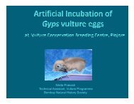
Whitebacked Vulture (Gyps bengalens
- Page 10 and 11:
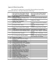
"Master Planning of Zoos" for Direc
- Page 12 and 13:
Indian Elephant (Elephas maximus in
- Page 14 and 15:
12 Assignment briefing on Developme
- Page 16 and 17:
Photo: Brij Kishore Gupta Inaugural
- Page 18 and 19:
Photo: Brij Kishor Gupta Speech by
- Page 20 and 21:
to collaborate with the Central Zoo
- Page 22 and 23:
occurred in the western world durin
- Page 24 and 25:
Black-headed Ibis (Threskiornis mel
- Page 26 and 27:
Photo: Brij Kishor Gupta Technical
- Page 28 and 29:
Technical Session I • Two to four
- Page 30 and 31:
Technical Session I Pre-project act
- Page 32 and 33:
Technical Session I 30 Maps showing
- Page 34 and 35:
Technical Session I Ecology and beh
- Page 36 and 37:
Technical Session I Reading ID numb
- Page 38 and 39:
Technical Session I Assisted reprod
- Page 40 and 41:
Technical Session I Policies and Gu
- Page 42 and 43:
Technical Session I Theme/Objective
- Page 44 and 45:
Technical Session I Disaster Manage
- Page 46 and 47:
Technical Session I 44 MASTER PLANN
- Page 48 and 49:
Technical Session I Stages of Plann
- Page 50 and 51:
Technical Session I 48
- Page 52 and 53:
Technical Session I Full Integrated
- Page 54 and 55:
Technical Session I “Immersion de
- Page 56 and 57:
Photo: Brij Kishor Gupta Technical
- Page 58 and 59:
Technical Session I Sustainable Pha
- Page 60 and 61:
Technical Session I Interactive Ses
- Page 62 and 63:
Technical Session I Research l The
- Page 64 and 65:
Technical Session I Animal First! "
- Page 66 and 67:
Technical Session I 64
- Page 68 and 69:
Technical Session I 66
- Page 70 and 71:
Technical Session I 68
- Page 72 and 73:
Technical Session I Summary § Thin
- Page 74 and 75:
Technical Session I 72 “Immersion
- Page 76 and 77:
Technical Session I Cultural Immers
- Page 78 and 79:
Technical Session I 76 Plus Animal
- Page 80 and 81:
Technical Session I Tools of Change
- Page 82 and 83:
Technical Session II Brahminy Kite
- Page 84 and 85:
Technical Session II What do you st
- Page 86 and 87:
Technical Session II Animal Husband
- Page 88 and 89:
Technical Session II 86
- Page 90 and 91:
Technical Session II About Exhibits
- Page 92 and 93:
Technical Session II Trends in Disp
- Page 94 and 95:
Technical Session II Planning for G
- Page 96 and 97:
Technical Session II Planning for G
- Page 98 and 99:
Technical Session II Sources of Con
- Page 100 and 101:
Technical Session II Typical Illust
- Page 102 and 103:
Technical Session II Prioritizing G
- Page 104 and 105:
Technical Session II Landscape plan
- Page 106 and 107:
Technical Session II Collection Pla
- Page 108 and 109:
Technical Session II How to Prepare
- Page 110 and 111:
Technical Session II 108 MASTER PLA
- Page 112 and 113:
Technical Session II • On 29th De
- Page 114 and 115:
Technical Session II 112 PRESENT SC
- Page 116 and 117:
Technical Session II • Landscapin
- Page 118 and 119:
Technical Session II 116 NOTABLE AT
- Page 120 and 121: Technical Session II 118 AWARDS & H
- Page 122 and 123: Technical Session II Types of Colle
- Page 124 and 125: Technical Session II SPARKS (Single
- Page 126 and 127: Technical Session II A Paradigm A P
- Page 128 and 129: Technical Session II Why paradigms
- Page 130 and 131: Technical Session II We Need To Be
- Page 132 and 133: Technical Session II Assignment bri
- Page 134 and 135: Technical Session II Willie B. - Zo
- Page 136 and 137: Technical Session II Islands: Louis
- Page 138 and 139: Technical Session II Chimpanzees at
- Page 140 and 141: Technical Session III Blackbuck (An
- Page 142 and 143: Technical Session III WZACS Integra
- Page 144 and 145: Technical Session III The usual out
- Page 146 and 147: Technical Session III 144 Homo sapi
- Page 148 and 149: Technical Session III 146 North Ame
- Page 150 and 151: Technical Session III Tuatara-200 m
- Page 152 and 153: Technical Session III 150 Large Car
- Page 154 and 155: Technical Session III South America
- Page 156 and 157: Technical Session III Australia New
- Page 158 and 159: Photo: Brij Kishor Gupta Technical
- Page 160 and 161: Technical Session III Maintenance o
- Page 162 and 163: Technical Session III • Impact of
- Page 164 and 165: Technical Session III l Cold storag
- Page 166 and 167: Technical Session III • Veterinar
- Page 168 and 169: Technical Session III White Tiger (
- Page 172 and 173: Technical Session III 170 Land Surf
- Page 174 and 175: Technical Session III Water managem
- Page 176 and 177: Technical Session III Strategy - 1
- Page 178 and 179: Technical Session III ‘Water Rela
- Page 180 and 181: Technical Session III Why and How
- Page 182 and 183: Technical Session III Barrier Desig
- Page 184 and 185: Technical Session III One-sided wat
- Page 186 and 187: Technical Session III Boardwalk - W
- Page 188 and 189: Technical Session III Random Encoun
- Page 190 and 191: Technical Session III 188 Cheetah,
- Page 192 and 193: Technical Session IV Rhinoceros (Rh
- Page 194 and 195: Technical Session IV Education goal
- Page 196 and 197: Technical Session IV Information Of
- Page 198 and 199: Technical Session IV • An illustr
- Page 200 and 201: Technical Session IV 198 Botanic Ga
- Page 202 and 203: Technical Session IV Designing of I
- Page 204 and 205: Technical Session IV Interpretation
- Page 206 and 207: illustration: Dr. NVK Asraf Technic
- Page 208 and 209: Technical Session IV 206 Education
- Page 210 and 211: Technical Session IV Singnages - ex
- Page 212 and 213: Technical Session IV Using much of
- Page 214 and 215: Technical Session IV Location map s
- Page 216 and 217: Technical Session IV Education and
- Page 218 and 219: Technical Session IV Conservation s
- Page 220 and 221:
Technical Session IV 218 Animal exh
- Page 222 and 223:
Technical Session IV People Expect
- Page 224 and 225:
Technical Session IV Developing Vis
- Page 226 and 227:
Technical Session IV Amenities - Sh
- Page 228 and 229:
Photo: Brij Kishor Gupta Technical
- Page 230 and 231:
Technical Session IV 228 Budget Rs
- Page 232 and 233:
Technical Session IV Dove Tailing n
- Page 234 and 235:
Technical Session IV Sources of Raw
- Page 236 and 237:
Technical Session IV Brand New Imag
- Page 238 and 239:
Technical Session IV Master Plan Wo
- Page 240 and 241:
Photo: Brij Kishor Gupta Technical
- Page 242 and 243:
Technical Session IV Where to devel
- Page 244 and 245:
Technical Session IV Circulation
- Page 246 and 247:
Photo: Brij Kishor Gupta Technical
- Page 248 and 249:
Technical Session V The crisis mana
- Page 250 and 251:
Technical Session V n Micro plan n
- Page 252 and 253:
Technical Session V Zoo Administrat
- Page 254 and 255:
Photo: Brij Kishor Gupta Technical
- Page 256 and 257:
Technical Session V Develop our Vis
- Page 258 and 259:
Technical Session V • What is my
- Page 260 and 261:
Technical Session V How do I price
- Page 262 and 263:
Technical Session V Do Fund Raising
- Page 264 and 265:
Technical Session V Guideline for C
- Page 266 and 267:
Technical Session V Initiatives tak
- Page 268 and 269:
Technical Session V Asiatic Lion §
- Page 270 and 271:
Technical Session V § A pair of un
- Page 272 and 273:
Technical Session V Behavioural obs
- Page 274 and 275:
Technical Session V Coffee plantati
- Page 276 and 277:
Technical Session V LTM in Island m
- Page 278 and 279:
Technical Session V Assisted Reprod
- Page 280 and 281:
Technical Session V Red Jungle Fowl
- Page 282 and 283:
Technical Session V Criteria for de
- Page 284 and 285:
Technical Session V Overview of cap
- Page 286 and 287:
Photo: Brij Kishor Gupta Technical
- Page 288 and 289:
Technical Session V Leopard (Panthe
- Page 290 and 291:
Technical Session VI Indian Pied Ho
- Page 292 and 293:
Technical Session VI Visit to Baluk
- Page 294 and 295:
Technical Session VI Images and Mom
- Page 296 and 297:
Technical Session VI 294 TRAINING P
- Page 298 and 299:
Technical Session VI Participants A
- Page 300 and 301:
Technical Session VI Partner Organi
- Page 302 and 303:
Technical Session VI and plantings;
- Page 304 and 305:
Technical Session VI Planning as an
- Page 306 and 307:
Technical Session VI owner’s desi
- Page 308 and 309:
Technical Session VI b) Identify st
- Page 310 and 311:
Technical Session VI 308 l Grey wat
- Page 312 and 313:
Technical Session VI d) Research. e
- Page 314 and 315:
Technical Session VI zoos? Many hav
- Page 316 and 317:
Technical Session VI l If we would
- Page 318 and 319:
Technical Session VI and at the Mol
- Page 320 and 321:
Technical Session VI he will lead o
- Page 322:
Technical Session VI founded by the