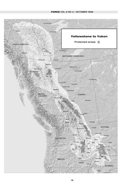
PARKS VOL 9 NO 3 • OCTOBER 1999 Yellowstone to Yukon 18 Protected areas:
in the Yukon to the rapidly growing towns surrounding the national parks around Banff, Glacier, and Yellowstone. In addition, the international border can act as a kind of psychological, legal, and management block to coordination between the northern and southern parts of the Rockies. Yellowstone to Yukon: big peaks, big wilderness, and big rivers As portrayed in the accompanying map, the Yellowstone to Yukon ecoregion can be defined generally as lands in the Rockies above about 1,050 m (3,500 feet) in elevation, characterised by extensive coniferous forests, and encircled at lower elevations by prairie grasslands. This is the headwaters for ten major river systems draining into the Pacific, Arctic, and Atlantic Oceans, supplying water for wildlife and human communities in the prairies, cities, and farms thousands of miles from the rivers’ mountain sources. When people think of Yellowstone to Yukon, though, they think first of mountains, and the drama of the region’s geology. In fact, Y2Y boasts the oldest rocks found in North America, as well as the largest geological displays of former volcanic activity in the world. Today, as they have for millennia, fire and ice shape the land. Given such rugged topography and punishing natural processes, it is surprising that so many plants and animal have claimed the Rockies as their home. Some bird species achieve their highest breeding densities in the Rockies, and some of the rarest species found in North America – the grizzly bear, wolf, black-footed ferret, and whooping crane – reside here. And, for at least the last 10,000 years, human beings have also called the region home. Y2Y comprises the traditional territory of 31 First Nations/Native American groups, each with a distinct culture, language, and history reflecting a way of life adapted to the plains, mountain recesses, forests, and grasslands. To native peoples, this was a sacred geography, shared by successive generations that renewed their relationships with the land through story and religious practices. To increasing numbers of people today, Y2Y provides a place for spiritual renewal and reflection in the beauty and solitude of wilderness. An ecoregional context Ecoregions have been defined as ‘large areas of the landscape determined by shared climate and geology, which, in turn, affect the kinds of ecosystems and animals and plants found there.’ Ecoregions can frame our thinking about the land, and about strategies to protect our natural heritage. Y2Y fits the broad definition of an ecoregion. The landscape shares common geologic, hydrologic, and climatic features, which in turn explain the similarities of plants and animals adapted to live here, ranging from caribou and bull trout to boreal and ponderosa pine LOUISA WILLCOX AND PETER AENGST 19 Pack trip above the Gataga River in the Muskwa-Kechika area of northern British Columbia. Photo: Wayne Sawchuk.