Parks - IUCN
Parks - IUCN Parks - IUCN
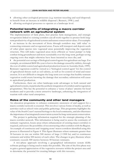
Figure Figure Figure Figure Figure 4. 4. 4. 4. 4. Continuity of remnant vegetation corridors in the western portion of the South Coast Region of Western Australia. PARKS VOL 9 NO 3 • OCTOBER 1999 Advantages of a macro corridor network to nature conservation The importance of our macro corridor network is its potential to provide some counter measures to compensate for the effects of habitat loss and fragmentation of ecosystems within the South Coast Region. Bennett, (1997) has discussed such benefits which in our case include: ❚ expanding the area of protected habitats for flora and fauna by encouraging longterm conservation agreements for native vegetation on private property and where necessary altering the purpose of vested Crown lands for the conservation of flora and fauna; ❚ maximising the condition of existing habitats through management of feral animals, weeds, fungal disease (e.g. Phytophthora), fire, and stock exclusion; ❚ minimising the detrimental impacts arising from surrounding land-uses (e.g. mitigating the effects of wind and water erosion); ❚ enhancing connectivity between existing areas of protected native vegetation providing conduits through which: - wildlife can disperse from areas which have reached maximum carrying capacity and/or competition, and recolonise other favourable habitats, perhaps improving the conservation status of the population; - wildlife can follow or escape local or longer-term seasonal changes in environmental conditions; - wildlife can reach previously separated populations with which breeding may take place, better maintaining and possibly improving genetic variability; 12
JOHN WATSON AND PETER WILKINS ❚ allowing other ecological processes (e.g. nutrient recycling and seed dispersal) to benefit from an increase in wildlife dispersal ( Bennett, 1998 ); and ❚ allowing ecological processes to operate at a landscape level. Potential benefits of integrating a macro corridor network with an agricultural system The implementation of farm plans, best practise farm management, and strategic revegetation linked to existing corridors can all work together to protect both longterm productivity of agricultural systems and nature conservation values. For example: ❚ an increase in the movement of biota through corridors may ‘add value’ to connecting remnants and revegetated areas. Fauna will transport and deposit seeds of other plant species into vegetated areas potentially improving the vegetation structure. This will make vegetated areas more efficient as ‘water pumps’ to help combat rising groundwater and more sustainable over the long-term, perhaps saving ongoing costs that might otherwise have been incurred as trees die; and ❚ the potential cost savings of biological control agents for agriculture are huge. For example, an estimated $600 M a year is lost to the damage caused by rabbits, through the cost of rabbit control and agricultural production losses in Australia (Gale, 1999). Remnant vegetation could be viewed as a ‘biological control agent’ for the control of agricultural threats such as soil salinity, as well as for control of wind and water erosion. It is not difficult to imagine the long-term cost savings that healthy remnant vegetation could create knowing the damage that secondary salinisation will cause to agricultural production. Furthermore, there are other landscape-scale advantages to both natural and agricultural systems, in particular the aesthetic integration of corridors and revegetation programmes. This has the potential to enhance a ‘sense of place’ amenity for local residents and to provide a more attractive landscape, enhancing the integration of tourism with other rural enterprises. Roles of the community and other land managers An education programme to enhance community awareness of and support for a macro corridor network is essential. This involves various forms of media, as well as activities such as school visits and public gatherings. This programme highlights the value of the South Coast’s natural heritage to the local community, and also illustrates the importance of an integrated conservation system for long-term nature conservation. The project is gathering information required for the strategic planning of the macro corridor network. This information is being used to assess the continuity of remnant vegetation, locate areas where enhancement of existing major corridors is required, and assess the possibility of reconstructing other corridors with the Region. An example of continuous and ‘stepping stone’ macro corridors identified using this process is illustrated in Figure 4. This figure illustrates where remnants greater than 50 hectares in size are within 500 metres of large (>1500 ha) and/or continuous remnants and within 500 metres of each other. The changes in grey illustrate where continuity exceeds 500 metres between 50-hectare remnants. A two-phase approach involving a geographical information system (GIS) software package is being used to make this possible. The aim of the first phase was to gain a general appreciation of the vegetative resource within the project area and to determine the potential for creating linkages with this resource. 13
- Page 1 and 2: Protected Areas Programme PARKS Vol
- Page 3 and 4: Editorial EDITORIAL KENTON R. MILLE
- Page 5 and 6: EDITORIAL information, and opportun
- Page 7 and 8: EDITORIAL fundamental elements and
- Page 9 and 10: The Western Australian South Coast
- Page 11 and 12: JOHN WATSON AND PETER WILKINS Weste
- Page 13: JOHN WATSON AND PETER WILKINS To re
- Page 17 and 18: JOHN WATSON AND PETER WILKINS We th
- Page 19 and 20: Yellowstone to Yukon: romantic drea
- Page 21 and 22: in the Yukon to the rapidly growing
- Page 23 and 24: LOUISA WILLCOX AND PETER AENGST low
- Page 25 and 26: LOUISA WILLCOX AND PETER AENGST ❚
- Page 27 and 28: The corridor of the Serra do Mar GE
- Page 29 and 30: GEORGE GEORGIADIS AND SILVANA CAMPE
- Page 31 and 32: GEORGE GEORGIADIS AND SILVANA CAMPE
- Page 33 and 34: GEORGE GEORGIADIS AND SILVANA CAMPE
- Page 35 and 36: GEORGE GEORGIADIS AND SILVANA CAMPE
- Page 37 and 38: GEORGE GEORGIADIS AND SILVANA CAMPE
- Page 39 and 40: MINGMA NORBU SHERPA AND UGEN P NORB
- Page 41 and 42: MINGMA NORBU SHERPA AND UGEN P NORB
- Page 43 and 44: MINGMA NORBU SHERPA AND UGEN P NORB
- Page 45 and 46: MINGMA NORBU SHERPA AND UGEN P NORB
- Page 47 and 48: MINGMA NORBU SHERPA AND UGEN P NORB
- Page 49 and 50: KENTON R. MILLER AND LAWRENCE S. HA
- Page 51 and 52: KENTON R. MILLER AND LAWRENCE S. HA
- Page 53 and 54: RÉSUMÉS Etablissement de liens en
- Page 55 and 56: Uniendo áreas protegidas para la c
- Page 57 and 58: PARKS VOL 9 NO 3 • OCTOBER 1999 5
- Page 59 and 60: Protected Areas Programme PARKS The
JOHN WATSON AND PETER WILKINS<br />
❚ allowing other ecological processes (e.g. nutrient recycling and seed dispersal)<br />
to benefit from an increase in wildlife dispersal ( Bennett, 1998 ); and<br />
❚ allowing ecological processes to operate at a landscape level.<br />
Potential benefits of integrating a macro corridor<br />
network with an agricultural system<br />
The implementation of farm plans, best practise farm management, and strategic<br />
revegetation linked to existing corridors can all work together to protect both longterm<br />
productivity of agricultural systems and nature conservation values. For example:<br />
❚ an increase in the movement of biota through corridors may ‘add value’ to<br />
connecting remnants and revegetated areas. Fauna will transport and deposit seeds<br />
of other plant species into vegetated areas potentially improving the vegetation<br />
structure. This will make vegetated areas more efficient as ‘water pumps’ to help<br />
combat rising groundwater and more sustainable over the long-term, perhaps saving<br />
ongoing costs that might otherwise have been incurred as trees die; and<br />
❚ the potential cost savings of biological control agents for agriculture are huge. For<br />
example, an estimated $600 M a year is lost to the damage caused by rabbits, through<br />
the cost of rabbit control and agricultural production losses in Australia (Gale, 1999).<br />
Remnant vegetation could be viewed as a ‘biological control agent’ for the control<br />
of agricultural threats such as soil salinity, as well as for control of wind and water<br />
erosion. It is not difficult to imagine the long-term cost savings that healthy remnant<br />
vegetation could create knowing the damage that secondary salinisation will cause<br />
to agricultural production.<br />
Furthermore, there are other landscape-scale advantages to both natural and<br />
agricultural systems, in particular the aesthetic integration of corridors and revegetation<br />
programmes. This has the potential to enhance a ‘sense of place’ amenity for local<br />
residents and to provide a more attractive landscape, enhancing the integration of<br />
tourism with other rural enterprises.<br />
Roles of the community and other land managers<br />
An education programme to enhance community awareness of and support for a<br />
macro corridor network is essential. This involves various forms of media, as well as<br />
activities such as school visits and public gatherings. This programme highlights the<br />
value of the South Coast’s natural heritage to the local community, and also illustrates<br />
the importance of an integrated conservation system for long-term nature conservation.<br />
The project is gathering information required for the strategic planning of the<br />
macro corridor network. This information is being used to assess the continuity of<br />
remnant vegetation, locate areas where enhancement of existing major corridors is<br />
required, and assess the possibility of reconstructing other corridors with the Region.<br />
An example of continuous and ‘stepping stone’ macro corridors identified using this<br />
process is illustrated in Figure 4. This figure illustrates where remnants greater than<br />
50 hectares in size are within 500 metres of large (>1500 ha) and/or continuous<br />
remnants and within 500 metres of each other. The changes in grey illustrate where<br />
continuity exceeds 500 metres between 50-hectare remnants.<br />
A two-phase approach involving a geographical information system (GIS)<br />
software package is being used to make this possible. The aim of the first phase was<br />
to gain a general appreciation of the vegetative resource within the project area and<br />
to determine the potential for creating linkages with this resource.<br />
13


