

Parks - IUCN
Parks - IUCN
Parks - IUCN

Create successful ePaper yourself
Turn your PDF publications into a flip-book with our unique Google optimized e-Paper software.
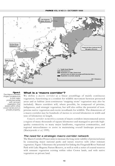
Figure Figure Figure Figure Figure 3. 3. 3. 3. 3.<br />
The Macro Corridor<br />
Project endeavours<br />
to link major<br />
protected areas<br />
with remnant<br />
vegetation that<br />
exists within other<br />
crown lands and on<br />
private property.<br />
PARKS VOL 9 NO 3 • OCTOBER 1999<br />
What is a ‘macro corridor’?<br />
We define a macro corridor as a linear assemblage of mainly continuous<br />
vegetation, functioning as a conduit for wildlife movement between protected<br />
areas and as habitat (non-continuous ‘stepping stone’ vegetation may also be<br />
included). Macro corridors will, where possible, be composed of pristine,<br />
indigenous, and strategic vegetation, but will also utilise the potential of nonpristine<br />
native vegetation and exotic woodlands for wildlife. The dimensions of<br />
a macro corridor may be hundreds of metres to several kilometres in width and<br />
tens of kilometres in length.<br />
A macro corridor network is a system of macro corridors interconnected across<br />
a region of many thousands of square kilometres and managed to provide highquality<br />
connectivity to many major landforms, vegetation communities, and<br />
regional microclimates to assist in maintaining overall landscape processes<br />
(Maciejewski et al, 1999).<br />
The need for a strategic macro corridor network<br />
The Macro Corridor Project aims to increase the long-term viability of protected areas<br />
by connecting major national parks and nature reserves with other remnant<br />
vegetation. Figure 3 illustrates the potential for linking the Fitzgerald River National<br />
Park with Lake Magenta Nature Reserve, as well as with a series of coastal reserves<br />
with remnant vegetation existing within other Crown lands, and with native<br />
vegetation on private land.<br />
10


