

2011 - Cooperative Institute for Research in Environmental Sciences ...
2011 - Cooperative Institute for Research in Environmental Sciences ...
2011 - Cooperative Institute for Research in Environmental Sciences ...

You also want an ePaper? Increase the reach of your titles
YUMPU automatically turns print PDFs into web optimized ePapers that Google loves.
NGDC-02Mar<strong>in</strong>eGeophysicsDataStewardship<br />
FEDERAL LEAD: SUSAN McLEAN<br />
CIRES LEAD: BARRY EAKINS<br />
NOAA Goal 4: Transportation<br />
Project Goal: Contribute to a streaml<strong>in</strong>ed, more fully automated,<br />
accessible, and Web-based management and stewardship process<br />
<strong>for</strong> mar<strong>in</strong>e geophysical data <strong>in</strong> support of seafloor research<br />
at CIRES and throughout the environmental science community.<br />
Milestone 1. Search, target, acquire and provide access to<br />
new and historical mar<strong>in</strong>e geophysical data (e.g., bathymetry,<br />
gravity, seismic and magnetics) from the global oceanographic<br />
community.<br />
S<strong>in</strong>ce July 2010, 230 multibeam swath sonar surveys<br />
(904,199 nautical miles) and 26 trackl<strong>in</strong>e (s<strong>in</strong>gle-beam<br />
bathymetry, magnetics, gravity and seismic reflection) surveys<br />
(67,462 nautical miles), throughout all of the world’s<br />
oceans, have been added to the National Geophysical<br />
Data Center’s (NGDC) global mar<strong>in</strong>e geophysical archives<br />
by NGDC and CIRES staff. Both national and <strong>in</strong>ternational<br />
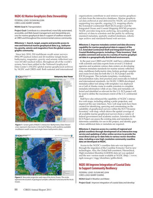
Figure 1: Screen grab of NGDC’s <strong>in</strong>teractive ‘Bathymetry Data Viewer.’<br />
L<strong>in</strong>es represent ship tracks <strong>in</strong> the Gulf of Mexico with publicly available<br />
multibeam swath sonar and s<strong>in</strong>gle-beam bathymetric data.<br />
Figure 2: New polar projection web map of the Arctic Ocean. The circles<br />
represent the location of geological samples collected <strong>in</strong> and around the Arctic<br />
Ocean.<br />
88 CIRES Annual Report <strong>2011</strong><br />
organizations contribute to and retrieve mar<strong>in</strong>e geophysical<br />
data from the <strong>in</strong>teractive databases. Mar<strong>in</strong>e geophysical<br />
data archived at and delivered by NGDC are currently<br />
support<strong>in</strong>g two specific, ongo<strong>in</strong>g U.S. mapp<strong>in</strong>g ef<strong>for</strong>ts:<br />
the Extended Cont<strong>in</strong>ental Shelf (ECS) project and the<br />
Integrated Ocean and Coastal Mapp<strong>in</strong>g (IOCM) program.<br />
NGDC provides long-term archiv<strong>in</strong>g, stewardship and<br />
delivery of data to scientists and the public by utiliz<strong>in</strong>g<br />
standard metadata, spatially enabled databases, robotic<br />
tape archive and standards-based web services.<br />
Milestone 2. Improve metadata content and data discovery<br />
capability <strong>for</strong> mar<strong>in</strong>e geophysical data <strong>in</strong> support of the<br />
U.S. Extended Cont<strong>in</strong>ental Shelf and Integrated Ocean and<br />
Coastal Model<strong>in</strong>g projects, <strong>in</strong>clud<strong>in</strong>g a “Data Inventory” that<br />
enables comment and access to a variety of mar<strong>in</strong>e geophysical<br />
data <strong>in</strong> a geographically distributed environment.<br />
In the past year CIRES and NGDC staff have collaborated<br />
with scientists and data experts from several U.S federal<br />
agencies and academic science data centers on develop<strong>in</strong>g<br />
common metadata standards <strong>for</strong> mar<strong>in</strong>e seismic reflection<br />
data, multibeam bathymetric data, bottom geologic samples<br />
and cruise level data <strong>for</strong> both the U.S. ECS project and the<br />
IOCM program. This <strong>in</strong>cludes templates, vocabularies,<br />
documentation rules, best practices and crosswalks to federal<br />
and <strong>in</strong>ternational standards. An NGDC/CIRES-developed<br />
metadata editor tool along with templates was deployed<br />
on a Gulf of Alaska cruise to enable scientists to complete<br />
metadata <strong>in</strong><strong>for</strong>mation while at sea. Data and metadata collected<br />
and identified as relevant <strong>for</strong> the U.S. ECS project will<br />
be used to def<strong>in</strong>e the maximum extent of the U.S. cont<strong>in</strong>ental<br />
shelf.<br />
Staff have also enhanced the capability of NGDC’s <strong>in</strong>teractive<br />
web maps, <strong>in</strong>clud<strong>in</strong>g add<strong>in</strong>g a polar projection, and<br />
improved the user <strong>in</strong>terfaces. New web map tools have been<br />
created <strong>for</strong> identify<strong>in</strong>g, query<strong>in</strong>g and comment<strong>in</strong>g on the<br />
suitability of geophysical surveys with<strong>in</strong> the ECS ‘Dynamic<br />
Inventory’ web map, which shows the spatial coverage of<br />
all available mar<strong>in</strong>e geophysical surveys from a variety of<br />
federal government and academic sources. Scientists on the<br />
ECS Project can assess the exist<strong>in</strong>g data and metadata to<br />
determ<strong>in</strong>e suitability <strong>for</strong> use <strong>in</strong> the project, and identify gaps<br />
where additional data or metadata are required.<br />
Milestone 3. Improve access to a variety of regional and<br />
global coastl<strong>in</strong>es through development of an <strong>in</strong>teractive map<br />
service and updat<strong>in</strong>g of other onl<strong>in</strong>e services to provide the<br />
most direct and up-to-date l<strong>in</strong>ks to various vector shorel<strong>in</strong>e<br />
data, <strong>in</strong>clud<strong>in</strong>g a new high-resolution community coastl<strong>in</strong>e<br />
data set developed at NGDC.<br />
Access to the NGDC’s coastl<strong>in</strong>e data sets was improved<br />
through the migration of the Coastl<strong>in</strong>e Extractor Tool to new<br />
technologies. Also, the Global Self-consistent, Hierarchical,<br />
High-resolution Shorel<strong>in</strong>e (GSHHS) data set was updated<br />
and the new version made available at NGDC (http://www.<br />
ngdc.noaa.gov/mgg/shorel<strong>in</strong>es/gshhs.html).<br />
NGDC-08ImproveIntegrationofCoastalData<br />
toSupportCommunityResiliency<br />
FEDERAL LEAD: SUSAN MCLEAN<br />
CIRES LEAD: BARRY EAKINS<br />
NOAA Goal 3: Weather and Water<br />
Project Goal: Improve <strong>in</strong>tegration of coastal data and develop


